Oneonta Gorge at 125 years… and an uncertain future?

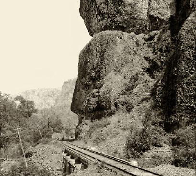
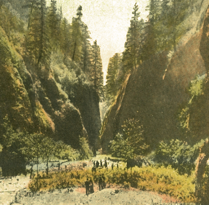
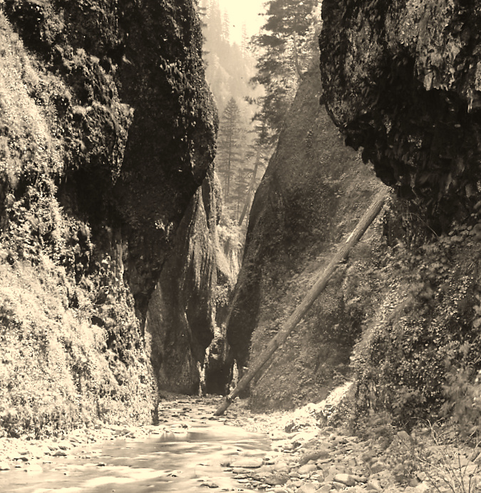
Oneonta Gorge in the 1890s

Oneonta Gorge has been around since the ice age Missoula Floods shaped much of the modern landscape in the Columbia River Gorge 14,000 years ago.  Yet, in the past 125 years this exquisite work of nature has endured new threats brought on by the explosion of an especially pernicious invasive species: us! 

The past two decades have been especially unkind to Oneonta Gorge, with a massive wave of flip-flop wearing visitors drawn here by the invention of social media, followed by a catastrophic human-caused fire in 2017. This article is a retrospective on how we arrived at this crossroad, and what the future might hold for beautiful Oneonta Gorge.

1900-1940s: Early days at Oneonta…

Railroad tracks had arrived at Oneonta Bluff by the 1880s

First peoples in the Pacific Northwest populated the Columbia River Gorge by the thousands for millennia, and they no doubt knew about and visited places like Oneonta Gorge, just as we do today. But it wasn’t until the transcontinental railroad was connected through the Gorge on the Oregon side in 1882 that white settlement began in earnest. Most of the early focus was on logging the big trees grew on the Gorge slopes and harvesting the seemingly endless salmon runs in the river. 

That changed in the 1890s when a new stream of visitors began to follow the rails into the Gorge. Tourists, mostly from Portland, seeking the scenic wonders at each of the train stops along the way. In fact, some of the earliest parks in the Gorge were originally owned and operated by the City of Portland (including Multnomah Falls) to serve the growing interest.

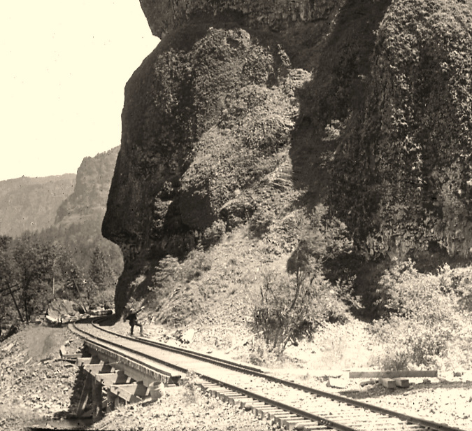
Highway surveyor – possibly Samuel Lancaster, himself –pointing to the site of the future Oneonta Tunnel in the early 1910s

The trickle turned to a tidal wave in the early 1900s, when local entrepreneur Sam Hill and his visionary road designer Samuel Lancaster opened the world-class Columbia River Highway to automobiles. Known today as the Historic Columbia River Highway, the artfully designed new road brought visitors to the Gorge by the thousands by the time it was completed in 1922, with dozens of roadside inns and restaurants springing up to serve the steady stream of motorists.

At Oneonta Gorge, Samuel Lancaster navigated a pinch point where the railroad tracks crowded the base of Oneonta Bluff by blasting a tunnel through the cliff for the new road. From the bridge at the west approach to the new tunnel, visitors also had a stunning view directly into Oneonta Gorge from their automobiles. As with other scenic spots along the road, Lancaster designed a pullout and even engineered a short, winding staircase down to the cool waters of Oneonta Creek that he knew tourists would want to explore.

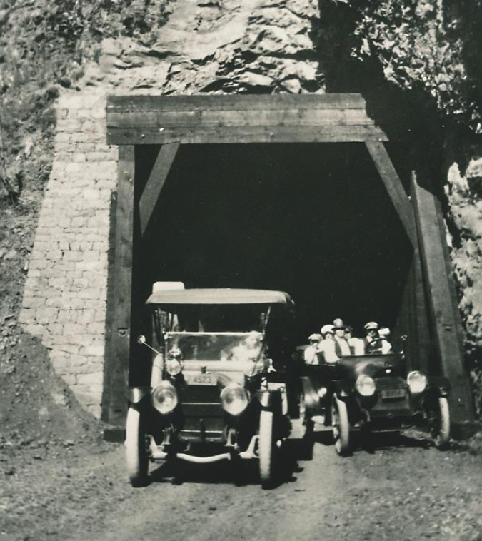
Motorists emerging from the Oneonta Tunnel in the late 1910s

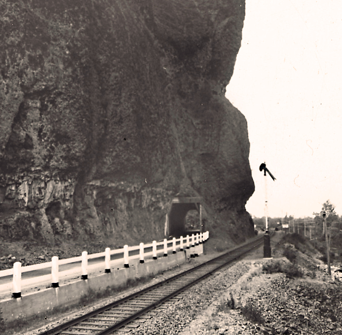
The east portal to the Oneonta Tunnel in the 1920s shows how the new highway was threaded between the vertical walls of Oneonta Bluff and the railroad – the pinch point that required construction of the tunnel

Curiosity inspired more intrepid visitors to wade into Oneonta Gorge, discovering that at the south end of the 1/3 mile long box canyon you are rewarded with a rare view of beautiful Oneonta Falls. Soon, the word was out, kicking off would be become a century of weekend adventurers making their way through the narrow gorge.

Despite its unique beauty and proximity to the new road, Oneonta Gorge was spared commercial development in the early days of motorists flocking to the new highway, when tourist stops dotted the route at many of the popular scenic spots. 

In the 1920s and 30s, most of the forest trails we know today were constructed by the Forest Service and Civilian Conservation Corps (CCC) to bring hikers to the series of waterfalls in the upper canyon of Oneonta Creek. These trails offered  new views into Oneonta Gorge from above, though wading the creek remained the only way to reach Oneonta Falls.

Visitors at Oneonta Gorge in the early 1900s

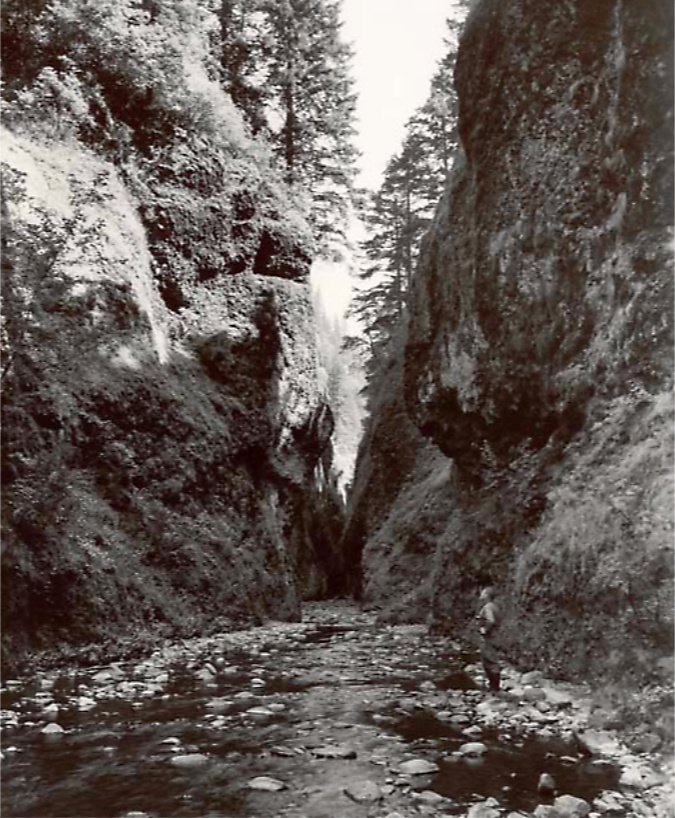
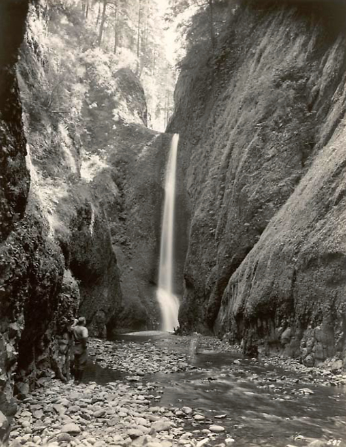
As the popularity of the area grew, the first photos from within Oneonta Gorge and of Oneonta Falls begin to appear in postcards, travel guides and tourist folios from this era. The pair that follow from the 1930s track a hiker (perhaps the photographer?) exploring Oneonta Gorge in late summer, when the water levels are typically low. Well into the 1990s, the trip through Oneonta Gorge was much like this, with just a few knee-deep pools to navigate in reaching the falls.

Oneonta Gorge and hiker in the 1930s

Oneonta Falls and hiker in the 1930s

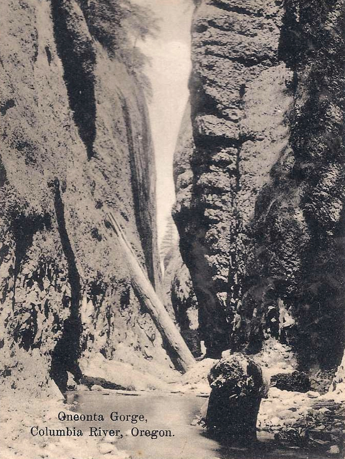
This postcard view (below) from the 1930s is notable in showing boulders and a large log blocking Oneonta Gorge. From my own experiences there, the route was clear of debris on this scale from the mid-1970s until the rockfall that triggered the modern logjam in the late 1990s.  What happened to the debris in this photo? They were simply broken up and swept away.

1930s postcard showing boulders and logs in Oneonta Gorge similar to today

Oneonta Gorge was created by a perpetual cycle of erosion, with the stream continually undercutting the vertical basalt walls, then clearing boulders and debris that periodically collapses into the stream. During high runoff events from November through March, Oneonta Creek can become a raging torrent, with enormous hydraulic force that can easily move whole trees and large boulders downstream, eventually breaking them apart into smaller, even more easily transported rock and debris the process (more on that toward the end of this article).

The tunnel at Oneonta Creek was an uncomfortably tight squeeze for passing vehicles from the beginning, so when the railroads moved their tracks away from cliffs of Oneonta Bluff sometime in the early 1940s, ODOT took the opportunity to move the road and bypass the old tunnel.

Oneonta Tunnel in the early 1940s with the relocated railroad line already away from the bluff

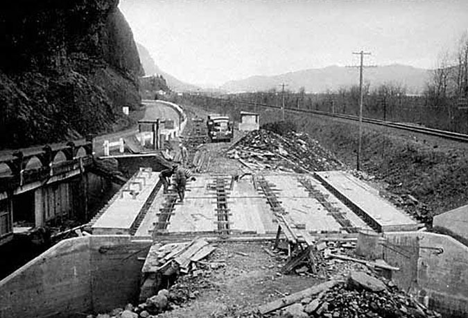
The tunnel bypass involved constructing a new bridge over Oneonta Creek (below), immediately adjacent to the old bridge. Both bridges survive today, with the newer bridge serving as the Historic Columbia River Highway route and the original bridge leading pedestrians and cyclists to the restored Oneonta Tunnel. 

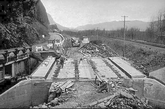
“New” highway bridge bypassing the Oneonta Tunnel under construction in 1948. The original bridge can be seen on the left

The tunnel bypass was completed in 1948 (below), and both ends of the Oneonta Tunnel were blocked with fill to prevent access. The original highway stub over the old bridge was left in place as a wayside for visitors to Oneonta Gorge.

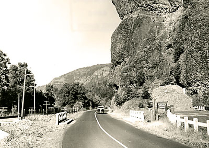
The completed bypass in the early 1950s with the old tunnel blocked with fill

The Oneonta Tunnel bypass in 1948 was part of a larger effort by the Oregon Highway Division to realign the original Columbia River Highway as a river-level route, completely bypassing whole sections, including the famous loops that climb over Crown Point and Rowena Crest. 

Much of this work was completed by the early 1950s, but in 1956 the federal Interstate and Defense Highways Act set construction of today’s Interstate-84 in motion, relegating the original versions of the Columbia River Highway to scenic routes in some areas, and being completely abandoned in others.

That might have been the end of the story for the mothballed Oneonta Tunnel, save for the following provision in the 1986 Columbia River Gorge National Scenic Area legislation:

This unique provision was way ahead of its time in our country by recognizing the historic and recreation value of old, “obsolete” roadways. Since then, ODOT has steadily worked toward this bold vision with a string of exceptional restoration projects. As we approach the 40th anniversary of the scenic area legislation, a completely restored and reconnected historic route from Portland to The Dalles is on track to become a reality.

2003-09: Restoring the Oneonta tunnel and bridge

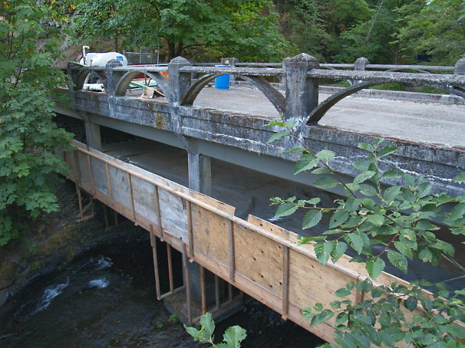
ODOT renovated the original Oneonta Bridge in the 2003

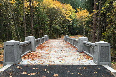
At Oneonta, the historic highway restoration included renovating the original highway bridge (above) and reopening the Samuel Lancaster’s original tunnel (below) after fifty years of closure. The 1948 tunnel bypass allowed for this segment to be reimagined as a pedestrian route, bringing visitors through the restored tunnel to a dramatic view from the historic bridge into Oneonta Gorge.

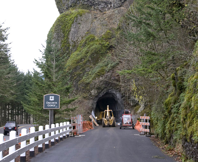
The newly excavated Oneonta Tunnel in 2006

Restoration of the east portal to the Oneonta Tunnel in 2006

Restoration of the west portal to the Oneonta Tunnel in 2006

The tunnel restoration included recreating the stonework surrounding both portals and a completely rebuilt, wood tunnel lining (below). 

Construction of the wood interior lining in the restored Oneonta Tunnel

The newly restored tunnel was opened to the public in 2009. For hikers, the new route connected a hiking loop between the Oneonta and Horsetail trail systems. For motorists, it was a new place to explore among the traditional stops along the historic highway.

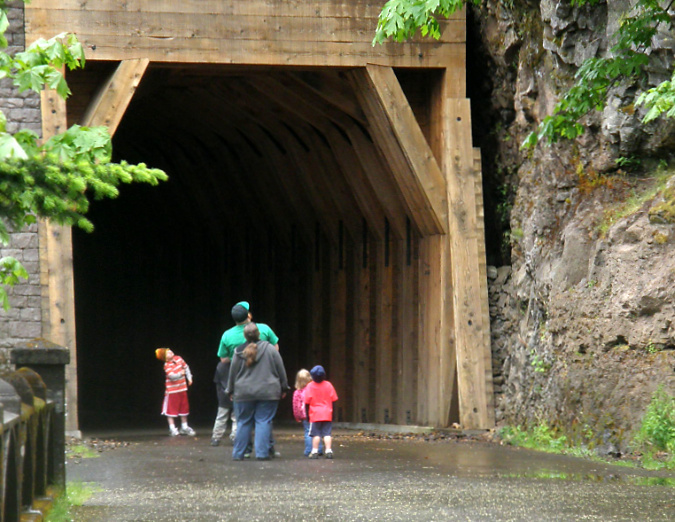
Hikers using the newly restored Oneonta Tunnel in 2009

Family exploring the newly restored Oneonta Tunnel in 2009

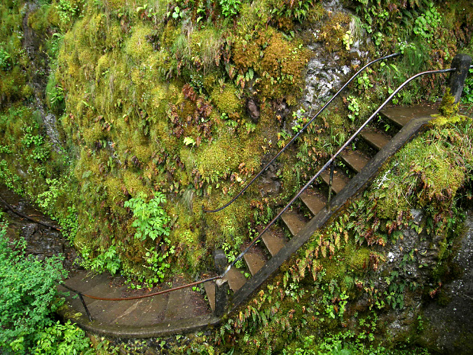
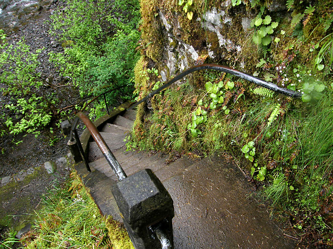
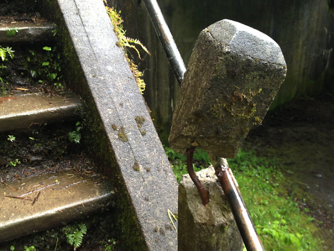
The Oneonta Bridge restoration included work at the west abutment, where a small alcove with an ornate bench from the original design was refurbished. This unassuming spot is one of the most delightful features in Samuel Landcaster’s vision for the highway. Knowing that visitors would want to explore, he built a tiny, winding staircase that hugs the cliff as it descends from the alcove to Oneonta Creek (below). The stairway is a fun surprise for visitors who stop, as it is not visible from the road.

Restored alcove and bench at the head of the winding staircase to Oneonta Creek in 2009

Historic winding staircase at Oneonta Creek in 2009

Looking down the historic winding staircase at Oneonta Creek in 2009

When these carefully crafted restoration efforts at Oneonta were finally opened to the public in 2009, few could imagine the impact that social media was about to unleash in the Gorge. Facebook had been founded in 2004, but only began its explosive growth in 2007, doubling from 50 million users to 100 million in 2008. It would reach a staggering 1 billion users by 2012. Instagram soon added to the impact after it was founded in 2010, reaching 10 million users within a year and 1 billion users by 2018. 

2010: The logjam + social media era… 

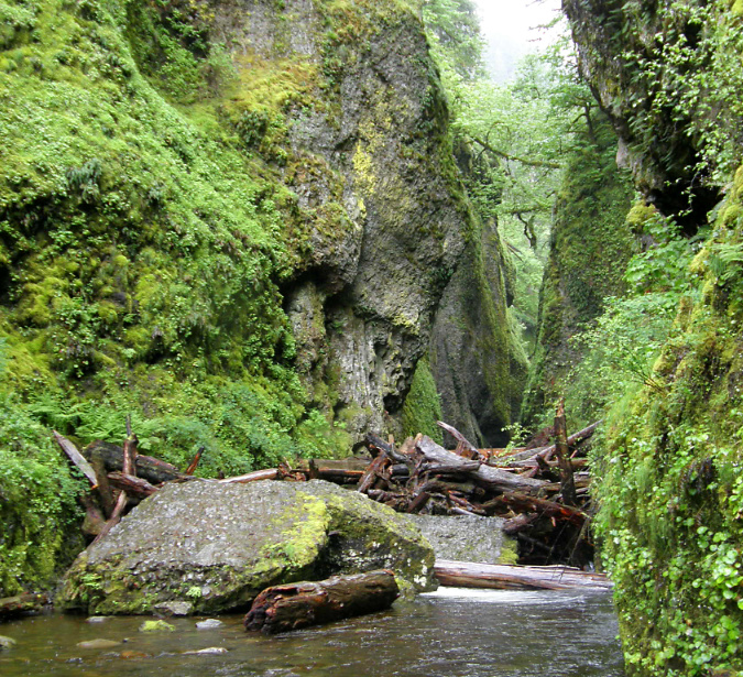
The Oneonta logjam in 2011

When you consider the recreation infrastructure in the Gorge – the trails, campground, picnic sites, scenic highway, Vista House and the lodge at Multnomah Falls – are much the same as they were in the 1930s, it’s surprising that the exponential growth in visitors in recent decades hasn’t been more destructive. That said, the arrival of social media, and its ability to concentrate large crowds overnight, impacted the Gorge, and especially Oneonta, like no nothing before. 

Compounding the “Instagram-effect” of social media in the years that followed reopening of the tunnel, the pair of van-sized boulders that had collapsed into the lower entrance to Oneonta Gorge in the late 1990s had stacked up enough logs to become a true hazard to cross. In the beginning, the boulders themselves weren’t difficult to navigate, but as log pile continued to grow, crossing the obstacle became a risky venture for social media novices drawn here by nothing more than a viral Instagram selfie. 

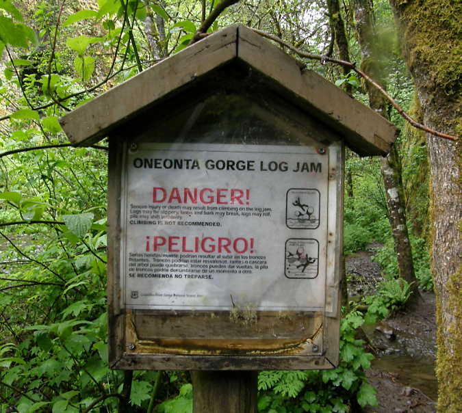
The Forest Service had posted a hazard warning around 2010, but Oneonta Gorge remained opened to the crowds that were growing exponentially each summer, and the signs went completely unnoticed by the growing horde.

Logjam warning sign in 2011

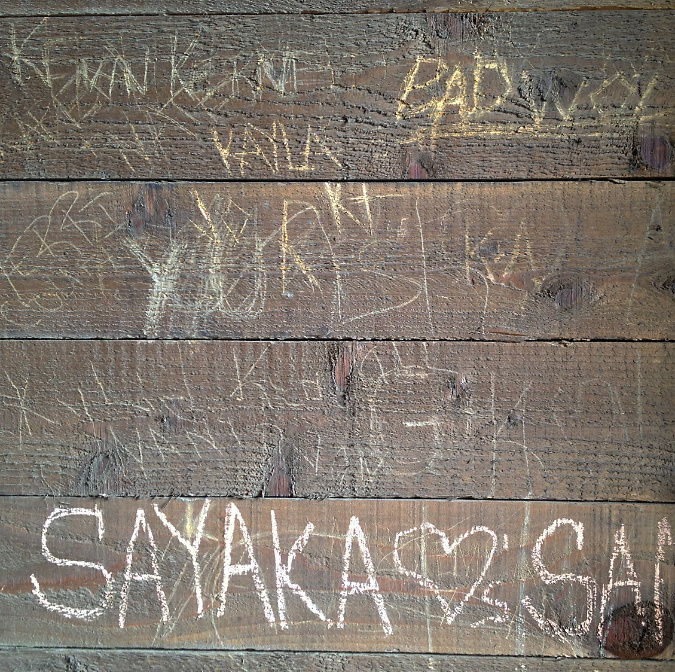
The growing summer crowds at Oneonta Gorge were beginning to impact the newly restored Oneonta Tunnel, as well. For anyone who loves the Gorge, it was maddening to see vandalism to the pristine wood lining in the tunnel when it started to appear in 2012. The heavy crowds eventually impacted other features, including damage to the railing on the historic, winding staircase (below) and the fragile ecosystem of Oneonta Gorge, itself. It was a classic tragedy of the commons in the making, with the Forest Service seemingly paralyzed from intervening.

Vandalism began to appear in the Oneonta Tunnel by 2013

Damaged staircase railing at Oneonta in 2013

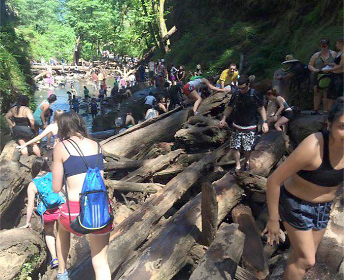
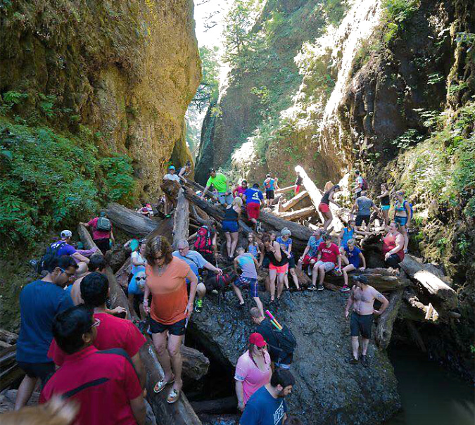
By 2015, the full brunt of social media – now including still more youth-oriented online platforms, like SnapChat and Reddit – was all too apparent at Oneonta Gorge. Summertime traffic came to a standstill on the old highway, with parked cars lining the shoulders in both directions and overflowing into the nearby Horsetail wayside. 

Oregon photographer extraordinaire T.J. Thorne (and a friend of the blog!) captured the following images that summer that describe the mayhem in ways words cannot match.

Social media crowds overwhelming Oneonta Gorge in the summer of 2015 (T.J. Thorne)

Crowds at Oneonta Gorge in the summer of 2015 (T.J. Thorne)

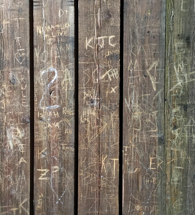
Vandalism in the tunnel spiked with the mobs, too, and by 2015 the beautifully restored walls had been almost completely destroyed by the thoughtless members of the summer crowds. Still more discouraging is that the damage was largely wrought by Millennials – a generation supposedly more in touch with environmental awareness, sustainability and mutual respect than any before it.

Vandalism overwhelmed the Oneonta Tunnel by 2015

Heavy vandalism to Oneonta Tunnel in 2015

Tragically, at least one person was killed while crossing the log jam during this unhinged period, and there’s no way to know how many were injured – nor what the environmental price to the unique ecosystem in Oneonta Gorge has been from so many people pouring into this relatively tiny space. Yet, there was still no effort by the Forest Service to limit or manage access… that is, until the Eagle Creek Fire in 2017.

2017: Gorge Fire… and the future?

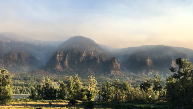
The Eagle Creek Fire as viewed from the Washington side of the Gorge in September 2017

The Eagle Creek Fire in 2017 reset everything in the Gorge. It was the first major fire since around 1900, yet was also somewhat typical of fires that have always burned in the Gorge. The only thing new about the event was the level of human development and activity that has come to the Gorge since the last big fire, underscored by the fact that it was a human-caused fire set off by a young hiker lighting fireworks on the Eagle Creek Trail.

The Oneonta Creek watershed was hit especially hard by the fire, with much of the upper basin completely burned. The immediate aftermath of the burn was a lot of surface erosion and falling trees killed by the fire. More locally, the fire killed trees and loosened rocks and debris along the rim of Oneonta Gorge, creating an immediate hazard to anyone below.

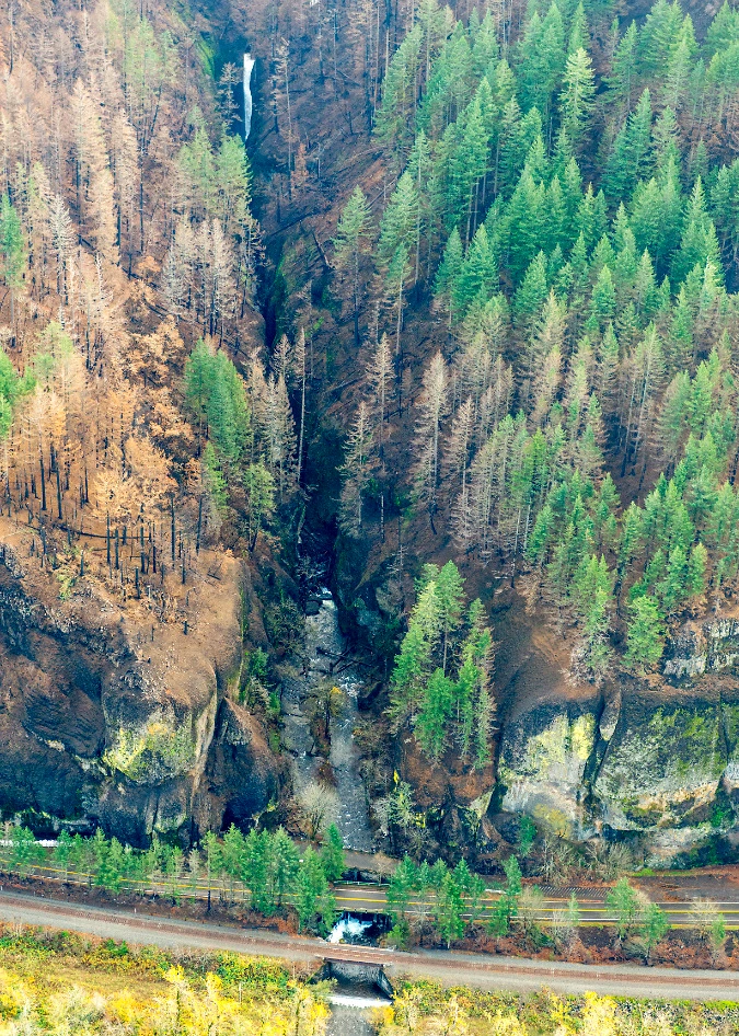
Aerial view of the fire impact along Oneonta Gorge in late 201. Oneonta Falls can be seen at the far end of the gorge in this view

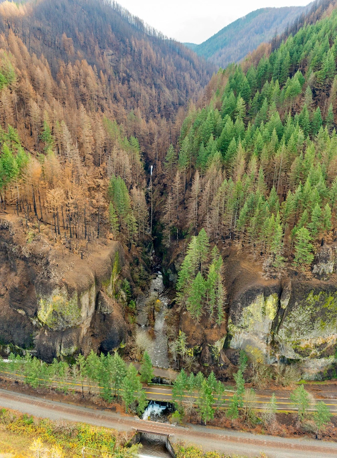
Aerial view of fire impact to Oneonta Gorge and the larger watershed in the distance in 2017

Over time, the extensive burn upstream has released hundreds of logs into Oneonta Creek, with many more to come. It didn’t take long for winter storms to carry these logs and other debris downstream to Oneonta Gorge, where the logjams have now grown to epic proportions.

Forest Service crew documenting the growing, post-fire logjams in Oneonta Gorge in 2023 (USFS)

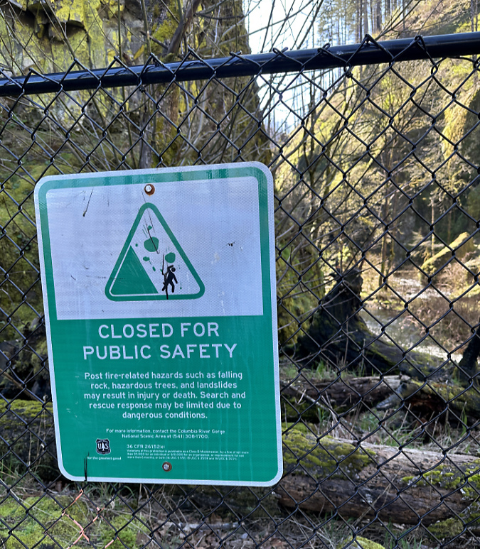
Most of the burn was immediately closed to the public after the fire, but the Forest Service has gradually reopened much of the area as trails are cleared and the forest recovery takes hold. An exception is Oneonta Gorge, however, where the agency continues to prohibit public access.

That’s a good thing, and overdue. Nobody knows how long it will take for Oneonta Creek to clear the logjams from Oneonta Gorge, but the hazards they create should at least help the Forest Service take the time to enact a new access policy that limits when and how many people are allowed to enter the gorge. 

Oneonta Gorge sign announcing indefinite closure following the 2017 fire

Statesmen Journal outdoor reporter (and another friend of the blog!) Zach Urness recently reported on Forest Service plans to consider reopening Oneonta Gorge later in this decade. According to Zach’s reporting, the agency will consider these options for the future:

1) Unrestricted access

2) Complete closure to access

3) Seasonal public access outside of salmon and steelhead spawning

4) Open or seasonal public access with trigger points to limit use

My hope is that something like the fourth option will be pursued in the interest protecting Oneonta Gorge from being loved to death in the future. The Forest Service planning effort will begin later this year.

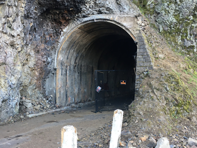
The Oneonta Tunnel became an inferno during the 2017 Eagle Creek Fire (USFS)

The fire had a devastating impact on the Oneonta Tunnel, as well. When I saw the above image of the tunnel in flames during the 2017 Eagle Creek Fire, I had mixed emotions: the first was sadness over the loss of this beautifully restored piece of our history, and the second was a sense of opportunity. If the tunnel were restored again, perhaps this time it could be more closely managed to prevent the grotesque scale of vandalism that had defaced it before the fire?

West portal to the Oneonta Tunnel immediately after the 2017 fire (ODOT)

East portal to the Oneonta Tunnel immediately after the 2017 fire (ODOT)

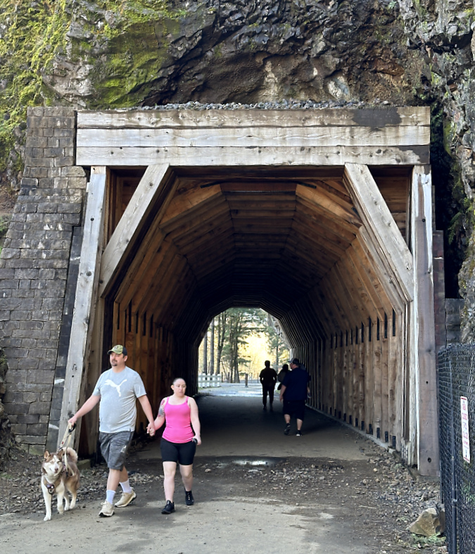
In 2020, ODOT began repairs to the Oneonta Tunnel, once again bringing it back to its original glory with a wood-lined interior. The re-restored tunnel reopened to the public in May 2021.

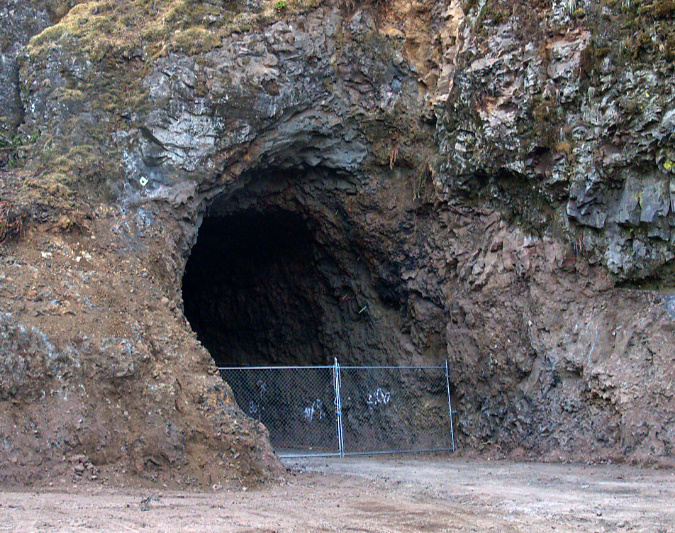
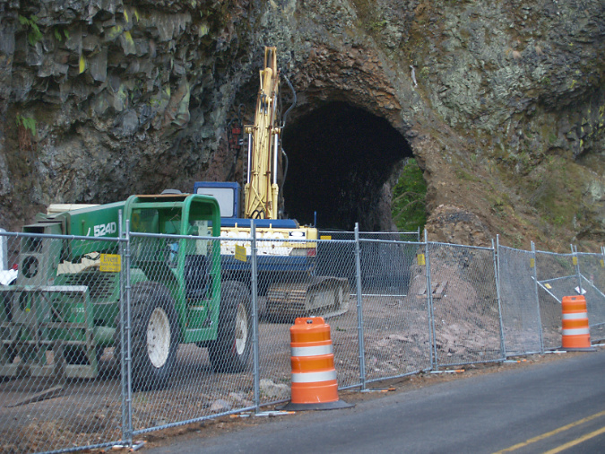
Oneonta Tunnel cleared and ready for repairs 2020

Re-restored the Oneonta Tunnel in 2024

Visitors exploring the reopened Oneonta Tunnel in 2024

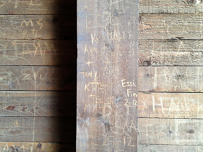
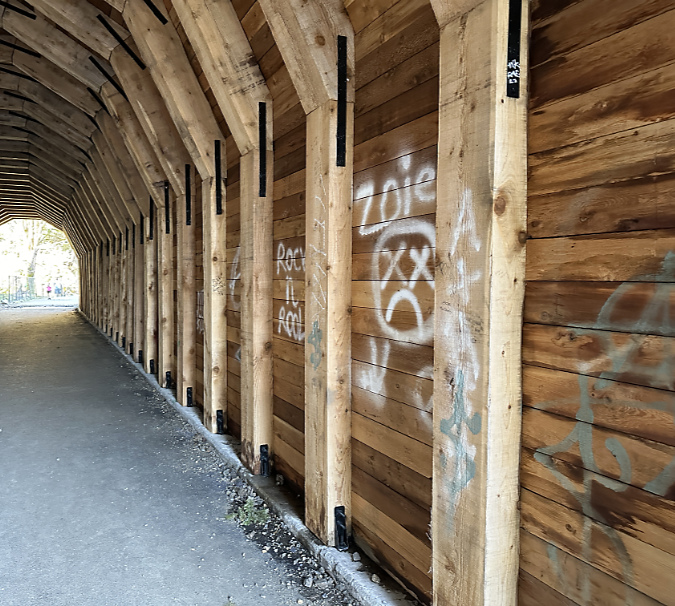
Though the Oneonta Gorge flip-flop crowds are no longer here, vandalism in the newly reopened tunnel continues, albeit at a more manageable pace. While much of the damage before the fire was from names and messages being carved into the soft wood, most of the new vandalism is in the form of spray paint tagging that bedevils our society pretty much everywhere these days. While frustrating, this damage is somewhat easier to repair – assuming ODOT has the capacity and makes it a priority to do so.

When the agency was drawing up plans for the restoring the tunnel a second time, after the fire, I testified to the steering committee that oversees the Historic Columbia River Highway restoration work to consider gating both ends of the tunnel and having State Parks rangers lock it during off-peak hours. I still think this could dramatically reduce vandalism in the tunnel.

Vandalism in the tunnel continues in 2024, despite the Oneonta Gorge closure

Oneonta Tunnel vandalism in 2024

What’s next for Oneonta Gorge? Mostly, a much-needed break from humanity, at least in the near-term. Hopefully, the Forest Service will opt for a long-term plan that places the ecological health of this place at the forefront, but nature has no timeline for clearing out the logs that are making it impassible right now. Over time, the force of water will win out, but that could be decades from now, perhaps longer.

Visitors walking the muddy shoulder to the east portal parking pullout in 2024

I’m also hopeful that ODOT will not only take action to keep pace with vandalism to the tunnel, but also continue to make minor improvements for visitors stopping to explore the tunnel and take in the view of Oneonta Gorge. One that stands out to me when I visits is the surprising lack of even a gravel path to serve the parking pullout near the east tunnel portal (above). A boot path has formed, of course, but I watched several visitors with young kids struggle between the choices of a muddy, narrow boot path and walking adjacent to traffic along the fog line of the eastbound highway lane. 

Horsetail-Oneonta wetlands in 2024

If you have followed this blog, you know I’ve posted several articles on Oneonta over the years. This piece surely won’t be the last! For past reads on this magical spot, here are some links:

Let’s Clear the Logjam at Oneonta (2011)

Oneonta Loop Trail (2020)

A Second Chance and New Vision for Oneonta? (2020)

If you’d like to hear a recent interview I had with Zach Urness on the future of Oneonta Gorge, you can listen here:

Explore Oregon Podcast: The ballad of beloved Oneonta Gorge

(…and yes, it’s true –I took my wife of nearly 40 years to wade Oneonta Gorge on our first date, way back in September 1981! She didn’t hold it against me…)

________________

Tom Kloster | April 2024
The Big Fir at Shepperd’s Dell

1920s postcard view of the Shepperd’s Dell Bridge and its iconic Douglas fir (colorized for this article)

A reader reached out a few weeks ago with a question about “that big fir tree at Shepperd’s Dell, and as it turned out, I had been working on an article on that very subject! The tree in question is unmistakable: it stands near the east end of the iconic Shepperd’s Dell Bridge, perhaps the most recognizable of the many graceful bridges along the Historic Columbia River Highway.

The big tree is a Douglas fir, Oregon’s official state tree, and it has been growing here since well before this section of the historic highway was constructed in 1914. The tree grows in a protected hollow, surrounded on three sides by basalt cliffs. George Shepperd, the local farmer who donated what is today’s Shepperd’s Dell State Natural Area to become a park, walked under the tree with his family on their regular visits to visit the waterfalls at Shepperd’s Dell from their farm, located just to the east. Today, countless visitors admire it from the shady wayside at the east end of the bridge.

1910s view of the west approach to Shepperd’s Dell with the big fir rising in front of Bishops Cap

Early photos of the new Shepperd’s Dell Bridge taken in the late 1910s (above) show the tree prominently framing the rock outcrop known as Bishops Cap, more than a century ago. At the time, the tree was large enough to easily be 60-70 years old, though it still had the symetrical shape of a relatively youthful tree.

The image below shows the 1910s scene in reverse, from atop Bishops Cap, with the big Douglas fir standing out in the foreground and a few early motorists parked along the opposite side of the highway.

1910s view looking west from the top of Bishops Cap toward Shepperd’s Dell Bridge, with early motorists and the big fir front and center at the east end of the bridge

This hand-colored postcard (below) from the 1930s features Bishops Cap, and the big Douglas fir is especially prominent in this view. The construction of Historic Columbia River Highway was famously designed to blend with nature and follow the contours of the land, but that still required road engineer Samuel Lancaster to do some fairly heavy blasting and grading to complete the scenic route. At Shepperd’s Dell, he graded the slope above the big fir, but clearly took care to protect the tree from fill debris, likely extending its life for another century.

1930s hand-tinted postcard view of Bishops Cap with the big fir prominently featured to the left

Here’s another hand-tinted 1930s postcard view (below) from the west end of the Shepperd’s Dell Bridge showing Bishops Cap and the big fir. When I first came across this image, I assumed that a fair amount of artist’s license was used to create the scene, since it appears to be from a point in space, where a vertical cliff drops directly below the historic highway.

1930s hand-tinted postcard view of the Shepperd’s Dell Bridge and the big fir in the upper left

However, I eventually came across the 1920s era photo (below) that the previous, hand-tinted image was created from. It turns out the photographer was part mountain goat and managed to capture the scene from a vertical slope below the old highway! As in the hand-tinted view, the big Douglas fir rises beyond the bridge, on the left.

This is the 1920s photograph that the previous hand-tinted scene was based upon, with the big fir in the upper left

This 1910s view (below) is perhaps the most popular of the early images of the Shepperd’s Dell Bridge. It appeared in both its black and white original form and in colorized versions on countless postcards and in souvenir folios that were popular with early motorists visiting the Gorge. At the time this photo was taken, many sections of the new highway were still unpaved, including the section at Shepperd’s Dell.

This is perhaps the most popular 1920s postcard view of Shepperd’s Dell Bridge, with the big fir on the left

Over the century since Samuel Lancaster built his iconic highway through the area, the big fir at Shepperd’s Dell has thrived, as shown in this pair of images (below). The arrows provide reference points on Bishops Cap that helps underscore just how much the old fir has grown in just over century when viewed from the same spot at the west end of Shepperd’s Dell Bridge.

A century passed between these views, but the big fir remains and has grown noticeably largerthe 2021 view is somewhat wider than the 1920s view to fully capture the big fir!

[click here for a larger version of this comparison]

In the 1920s view, the top of the big fir was visually just a big higher than the top of Bishops Cap. By 2021, the tree had not only added some 50 feet to its height, it had also spread out and formed a more rounded crown that is typical for mature Douglas fir. The upper arrow in the 2021 image points to what was the approximate top of the tree in the 1920s. The spread of the tree is noticeable in the 2021 image, as well, as it now obscures part of Bishops Cap from this perspective.

The big fir at Shepperd’s Dell after the fire..?

The charred base of the big fir at Shepperd’s Dell in 2018, one year after the fire

Today, the Shepperd’s Dell fir remains a familiar feature to those stopping at the wayside, a true survivor that stands out from the surrounding forest. Its stout trunk is much larger than other trees in the area, and there has always been a bit of a mystery about a plank attached to the tree and metal cable that disappears into the canopy (I won’t attempt to solve that in this article!). So, when Eagle Creek Fire swept through the Gorge and reached Shepperd’s Dell over Labor Day weekend in 2017, the fate of this old tree was on my mind.

In the immediate aftermath of the fire, it was clear that the big tree hadn’t crowned (meaning the fire hadn’t engulfed the entire tree), but a significant part of the crown had been scorched and the bark at the base of the tree was badly blackened. The understory around the tree was completely burned away, so it was clear the fire had burned hot when it swept through. Because the fire occurred toward the end of the growing season, when conifers are becoming dormant with the approach of winter, it was impossible to know if the living cambium layers under the big fir’s thick bark had been destroyed by the heat of the burn. That would have to wait until the next spring, when the stress of producing new growth would test the its ability to survive.

By the fall of 2018 — one year after the fire – the situation was discouraging. The old tree had put out very little new growth on its remaining green limbs in its first growing season after the fire. And while it retained many of its surviving limbs over the course of that year’s summer drought, many had dropped their needles and died back (below), leaving the tree with less than half its canopy intact. Still, it had managed to survive the first year following the fire.

Looking up at the badly scorched canopy of the big fir in 2018, one year after the fire

The group of younger Douglas fir around the big tree didn’t fare as well. Some had been immediately killed by the fire, while others that survived the initial blaze seemed to have lost too much living canopy to recover from the fire (below). During that first summer, the combined loss of green canopy and stress from the annual drought season was too much for many of these trees to survive their first year after the fire.

The scorched big fir and its smaller companions in 2018, one year after the fire

As the big fir at Shepperd’s Dell entered its second winter season after the fire in 2018-19, it wasn’t looking good at all. It has put on almost no new growth that year, and the annual needle drop that fall left even more blackened, bare limbs exposed.

Worse, the Oregon Department of Transportation (ODOT) was cutting down what it deemed to be hazard trees along the historic highway in the wake of the fire. This included scores of trees around Shepperd’s Dell, some of them living trees that were impacted by the fire, but still surviving. Its haggard appearance at the time (below) put the big fir at great risk of being defined a “hazard” by highway crews, but thankfully, it was spared from the chainsaws.

The Shepperd’s Dell fir in 2019… with less than half its canopy intact, the old tree was still hanging on…

Then, in the spring of 2019, the big fir pushed out a modest flush of new growth on its surviving limbs in its second season of growth following the fire. It wasn’t much, but it did signal that the tree was finally starting to rebound from the fire. It was no longer losing ground in its recovery.

As the spring of 2020 unfolded, our world seemed to stop as the COVID pandemic swept the globe, but for the big fir at Shepperd’s Dell, things were clearly looking up. The tree put on another flush of new growth in its third year following the fire, then another flush of new growth followed in the spring of 2021. While we hunkered down in the pandemic, the big fir was making its comeback (below).

The big fir makes a comeback: three growing seasons between these images show significant recovery of the crown and middle canopy

[click here for a larger version of this comparison]

Looking up into the canopy in 2021, the change in just three years of gradual recovery is dramatic (below). The big fir has been rebuilding its living canopy and thereby restoring its ability to actively grow, once again. Surprisingly, some of the new growth was also emerging from limbs that seemed to have been lost in that first year after the fire, but apparently had just enough living cambium layer left to allow new growth to emerge through the blackened bark.

Looking up into the recovering canopy of the big fir in late 2021

Today, the future of the big fir at Shepperd’s Dell seems much brighter. Its recovery is remarkable, considering how many of its neighbors were lost to the fire (below). But that’s no accident. Our largest conifers — Douglas Fir, Ponderosa Pine and Western Larch — typically drop their lower limbs as they grow. This adaption focuses growth at the top of their canopies, where they can absorb the most sunlight, but it also helps protect their living crowns when fires sweep through by denying a “ladder” of lower limbs that allow fire to climb up the tree to the main canopy.

Low intensity fires reinforce this adaptation, with the lowest limbs of moderately burned trees often succumbing to the fire, even as the tree survives, placing its crown still further above the reach of future moderate intensity burns. These “cool” fires are beneficial, helping thin the forest, remove accumulated fuel, invigorate the leafy understory and allow the largest trees to live on to continue anchoring the forest. Combined with thick, fire-resistant bark, these big conifer species define the “fire forests” along the east slopes of the Cascades, where fire is an essential part of the ecosystem, though Douglas Fir grows throughout the Cascades.

The big fir survives! But some of its companions did not…

While some of the area burned in the 2017 Eagle Creek fire fit the definition of “beneficial”, vast areas burned far too hot for any trees to survive, requiring whole ecosystems to restart from bare soil, and in turn, exposing bare soil to serious erosion. Today, modern forest management is increasingly embracing prescribed burns with moderately hot fires to mimic the frequent beneficial burns that were common before modern fire suppression began in the early 1900s. While still controversial for the risk that prescribed burns can potentially bring to rural property, their overwhelming benefit to the forest and role in preventing catastrophic fires is unquestionable.

Look closely at the burn patterns following the Eagle Creek Fire, and you will also see big conifers growing in moist canyons or shaded north-facing slopes were more likely to survive the fire. This has to do with the timing of the blaze. When the fire swept through over Labor Day weekend in 2017, Oregon’s forests were at their most stressed point in the growing season, with several months of drought and hot weather drying trees out and making their extremely vulnerable to fire.

Yet, trees with better access to moisture during the annual drought cycle are able to stay fully hydrated, and are much less vulnerable to the intense heat of a forest fire. This is also why some of our largest trees are found where summer moisture is available. Look at the bark on many of these trees, and you are likely to see ancient burn marks, often from multiple fires that these trees have survived over their long lives. As our forests cope with a changing, warming climate, these conditions favorable to survival will become increasingly important if we hope to continue to have big trees in our forests.

Aerial view of Shepperd’s Dell from 2019 showing the historic highway curving gracefully around the shaded hollow holding the big fir (ODOT image)

What does the future hold for the big fir at Shepperd’s Dell? In the near future, this old tree suddenly has less competition for water and nutrients from nearby trees that succumbed to the fire. For the longer term, it enjoys an excellent location for survival, growing in a shaded, moist bowl surrounded by protective cliffs that buffer it from the seemingly perpetual Columbia Gorge winds.

Douglas fir can live for centuries, and there’s no reason this old tree can’t outlive every human being walking on the planet today – and their children and grandchildren, too! Its most lethal threat is probably us. So, hopefully we will continue to give it the respect and space to grow that Sam Lancaster provided with his curving highway design more than a century ago, allowing many future generations to marvel at this old survivor, just as we do.


Previous WyEast Blog articles on the remarkable George Shepperd:

The Farmer and his Dell

Heirs to George Shepperd’s Legacy

Mount Hood National Recreation Area Legislation: 10 Things to know!

Mount Hood from Lolo Pass

After nearly ten years of informal meetings and town halls, Senator Ron Wyden and Rep. Earl Blumenauer recently released a much-anticipated framework for legislation that will fundamentally change the management direction for Mount Hood and expand protections for the Columbia River Gorge. 

The legislative details are forthcoming, but for now Sen. Wyden and Rep. Blumenauer are asking for public comment on a general legislative concept by January 7 – this Friday! That’s a very short comment period, but if you love WyEast Country (and you wouldn’t be reading this if you didn’t!) please consider weighing in, even if only to send a sentence or two on what is most important to you as this legislation takes shape.

Here are 10 things to know about this new proposal for Mount Hood and the Gorge:

1. It’s a very big deal for Mount Hood! At this time, it’s still a legislative concept, but it will frame the ultimate details of the legislation, and the scope of the concept is broad. This is the most sweeping legislation proposed for Mount Hood since the Oregon National Forest was created in 1908 (and later renamed the Mount Hood National Forest in 1924). This is a big deal for Mount Hood. More than the original Mount Hood Wilderness area created with the Wilderness Act in 1964, more than the subsequent wilderness additions in 1978, 1984 and 2009. And more than the Northwest Forest Act of 1992. 

Why? Because the legislation would shift the core function of the forest away from commercial logging and toward forest restoration and enhanced recreation. This is a sea change for the Forest Service – and for the mountain. The degree to which this pivot is enforced in law depends solely on what the coming legislation says, and therefore the importance of weighing in early and often (as Rep. Blumenauer likes to say).

2. It’s big deal for the Gorge, too! While the greatest impact of the proposed legislation would be on Mount Hood and the federal lands that surround the mountain, additional protections and recreation enhancements for the Gorge are part of the proposal. They represent the most important step forward since the Columbia River Gorge National Scenic Area was established in 1986.

Crown Point and the Columbia River Gorge

3. Say it with me: Mount Hood National Recreation Area! The central and most powerful feature of the legislative concept is a dramatic expansion of the Mount Hood National Recreation Area (NRA). “Expansion” you might ask? Since when has a Mount Hood NRA even existed? Since 2009, as it turns out – though few know this, and it’s understandable. The awkwardly titled “Lewis and Clark Mount Hood Wilderness” bill that President Obama signed into law in 2009 added new wilderness and a number of other protections for Mount Hood, but tucked into the bill were three small areas to the east and southeast of the mountain deemed the “Mount Hood NRA”. 

At the time, the creation of these NRA postage stamps was really just a consolation prize to mountain bikers who stood to lose access to trails falling inside the new wilderness areas. This is a frustrating and contentious issue among should-be conservation allies that was never anticipated when the Wilderness Act was signed into law in 1964 (bicycles are interpreted as mechanized, and thus excluded under the law). Though token as the original Mount Hood NRA units were, I wrote in this article several years ago that they also represented an opportunity to someday help Mount Hood achieve full recognition as a national treasure worthy of permanent protection. It was legislative foot in the door that may be about to open much wider.

The power of the NRA is clear in the legislative concept: it would encompass most of the Mount Hood National Forest north the Clackamas River, or roughly half the forest. The Forest Service would be thereby directed to write a new management plan for this vast area that focuses on forest restoration, recreation and watershed and water quality. This is a long-overdue change from the commercial logging mission that has hammered the mountain since the 1950s. As envisioned in the legislative concept, the new mandate would be to restore forest health and promote recreational activities that are in concert with a recovering forest that will be allowed to grow old, once again. 

Rainforest along Whale Creek on the Clackamas River Trail

Did you know the current plan guiding the Forest Service for their management decisions was adopted more than 30 years ago, in 1990? The Portland region, alone, has grown by well over 1 million residents in that time, but aside from expansion of the commercial ski resorts, recreation opportunities on Mount Hood haven’t expanded — with the resulting traffic and trailhead crowding we see as a familiar reminder. The legislative concept speaks directly to this crisis in management, with a clear directive to the Forest Service to change its focus to better reflect the interests and concerns of a changed region. This is a sea change for Mount Hood.

Conservationists remain wary of the NRA, however. Why? Because they rightly point to the fact that every NRA in this country is a bit different, each tailored to the specific area they were created for. In Oregon, this includes the Oregon Dunes and Hells Canyon, for example. While some NRAs are written with conservation in mind, others are relatively toothless and don’t give the Forest Service much direction in how to manage these areas. This is why the details in the legislative language matters. 

4. More Wilderness and Wild & Scenic Rivers. Senator Wyden has been particularly focused on expanding Oregon’s system of Wild & Scenic Rivers in recent years, a protection that mostly prevents rivers from being dammed, but also offers other protections intended to keep river corridors healthy and functioning for wildlife. The proposed legislation would add sections of the West Fork Hood River, Lake Branch, Coe and Eliot Branches, Cold Spring Creek and the Dog River to the Wild & Scenic River system in the Hood River basin, alone. On the west side of the mountain, sections of the Clear Fork of the Sandy River, Zigzag River and Still Creek would be added to the Wild & Scenic River system. The limit to this protection is that it only applies to public lands, and most of these streams flow through private lands, as well. These stretches located outside public ownership are not included in the legislative concept. 

Wilderness expansions are an expected part of any new conservation bill for Mount Hood and the Gorge, even though most of the truly wild areas have already protected through past legislation. Therefore, most of the new areas being proposed are expansions of existing wilderness, including Lost Lake Butte, the middle Coe and Eliot Branch canyons near Cloud Cap, popular Tamanawas Falls, the east side of Bluegrass Ridge, the Red Hill area along the Old Vista Ridge trail and several small expansions along the east end of the Salmon Huckleberry Wilderness.

Tamanawas Falls on Cold Spring Creek, one of the new wilderness areas in the proposed legislation

5. Moving trail stewardship up the Forest Service priority list? Ask someone who volunteers as a trail steward for one of the non-profits who work in WyEast Country (Trailkeepers of Oregon, Pacific Crest Trail Association, Mazamas, Backcountry Horsemen, Oregon Equestrian Trails, and Oregon Mountain Biking Coalition, to name among the most active) and they will tell you that one of the main obstacles in putting tools in the hands of volunteers on our trails is the Forest Service, itself. Compared to working with local and state land managers, navigating the Forest Service is a real challenge, even when you’re trying to bring needed resources in the form of volunteer labor.

The legislative concept builds on outreach conducted by Rep. Blumenauer’s staff to most of these groups to figure out what’s missing in the current Forest Service structure and what could be done differently to make trail stewardship volunteering easier. As written, the concept is a bit squishy, but the general themes of dedicating more Forest Service staff to serve as a coordination hub, and giving them new tools for coordinating virtually with volunteers is a good start. More thoughts on this topic follow in this article.

6. Talking with the tribes. This legislative concept has been in development for a while, and to the credit of Rep. Blumenauer and Sen. Wyden, it was slowed along the way to ensure meaningful consultation with affected tribes. As drafted, the legislative concept focuses on Forest Service obligations to better consult and coordinate with the tribes and to specifically to deliver on a first foods plan that would be added to the policies that guide forest management. More thoughts on this topic follow, as well.

Looking across the Columbia River to the town of Lyle from Rowena Plateau

7. Gorge Towns to Trails vision. Long advocated by Friends of the Columbia Gorge, this is a bold, long-term vision to create a European-style trekking network encircling the Columbia River Gorge National Scenic Area. The legislative concept gives a nod to the vision in all but name, along with a general direction to the Forest Service to develop a comprehensive system plan for all trails the Gorge. 

It’s no secret that in the past the Columbia Gorge Commission staff has viewed new trails in the Gorge quite negatively, and National Scenic Area staff have also been reluctant to consider trail expansion, as well. This, despite the overwhelming growth in demand and resulting overcrowding that is apparent to anyone who spends time in the Gorge. The proposed legislation would guide staff at both agencies with a clearer vision for how and where trails will be expanded in the Gorge, and how existing trails experiencing overuse can be better managed.

8. Improving Mount Hood & Gorge Transportation. Who can argue with this? It can only get better, right? And yet, this is perhaps the squishiest of the elements in the legislative concept, as most of what it calls for is already being provided and the concept simply calls for more – as in more public transit and transportation “options” (read: bikeways?), more rest areas, more law enforcement, more emergency response capacity. What the concept misses is that transportation, itself, is a recreation experience, not just a service. More thoughts on this topic follow below, as well.

The Dollar Lake Fire on Mount Hood (September 2, 2011)

9. Forest Fire “management”? Well, it’s safe to say that as a society we are beginning to grapple with the reality that a century of aggressive forest fire suppression coupled with a warming climate has set up an impossibly volatile circumstance in our forests. But I would emphasize the word “beginning”, because while the scientists and public agencies (and even a few politicians) understand the situation, there remains intense public pressure to somehow prevent forest fires – especially from people who live in the so-called “urban-rural interface”. This is policy jargon for people who live on private forested acreages abutting our public lands in places like the U.S. 26 corridor, and who are at real risk from catastrophic forest fires.

At best, we might be able to reduce the number of human-caused fires. These are still the majority, including the massive Riverside (2020) and Eagle Creek (2017) fires that scorched a large chunk of Mount Hood National Forest in the past five years. The proposed legislation tries to ease into this with by requiring the Forest Service to create a “mitigation and adaptation” plan for managing both fire risk and response. “Mitigation” would include prescribed burns and thinning crowded plantations on old clear cuts to improve forest health and fire resilience – two of the main ways the Forest Service is responding to the growth in catastrophic fires in the West. 

“Adaptation” is less defined in the proposed legislation, however. The elephant in the room are the thousands of homes and summer cabins (hundreds of them on federal land through 99-year leases) located in that “urban-rural interface”. Can they be protected? The fire that tore through the communities of Talent and Phoenix in Southern Oregon in 2020 didn’t stop at the urban-rural interface, they burned right in developed urban areas. “Adaptation” suggests that we might change how and where we live in relations to forests in the future, so what does that mean for the urban-rural interface, before or after fire? I don’t envy the Forest Service on this task, nor will this legislation solve the larger policy dilemma, but there’s no question it will need to be part of developing a Mount Hood NRA plan.

In a rare moment of justice, these target shooters were caught in a no shooting zone on Wildcat Mountain, and asked to clean up their trash while the deputy watched (2010)

10. Who isn’t for public safety in our forests? This is another topic the proposed legislation didn’t have much choice in acknowledging. Most who visit Mount Hood in the Gorge are keenly aware of the lawless activity that finds refuge in a vast area with little law enforcement presence. The legislative concept calls for more funding, including for local law enforcement, as well as “public education”. More thoughts on this topic follow, as well.

So, I’ve highlighted the main take-aways as a WyEast advocate who has long dreamed of a fundamental shift on management focus like this, but the legislative concept has more.

You can download the concept document here:

Draft Legislative Concept

You can also view and download the surprisingly detailed draft concept map here:

Draft Concept Map

And you can comment directly on the proposed Mount Hood NRA legislation here:

Public Comment Form

This will take you to an online form for sharing your thoughts. The following are what I plan to share during this comment period – and they might be useful to you, as well.

What’s Missing from the Concept?

Though there’s a looming comment deadline of January 7 (this Friday!), this legislative process is just getting started, and there will be more opportunities to weigh in while congressional staff drafts the actual legislation. With any luck (and some will be needed!) and enough support, this just might make it through the most divisive Congress in recent memory.

Here are a few things I’d like to see in the new Mount Hood legislation:

1. Restorative justice for the tribes. This means more than “living up to our statutory obligations”, as currently written in the legislative concept. Most of the statutes governing tribes in this country are rooted in our dark history of displacement and oppression of native populations, and the presumption that what was taken from the tribes must forever be lost. Restorative justice means to reverse the harm, and for Mount Hood and the Gorge might include restoring the ecosystems that provide first foods – as included in the legislative concept. But it might include dedicating or expanding public lands for the sole purpose of restoring exclusive tribal access to sacred places.

Restorative justice should include an inventory of interpretive and directional signage and symbols, too, to become inclusive of pre-white settlement history and customs, and reverse some of the cultural erasure caused by place names and white-centric written history. The most egregious examples are interpretive signs located along the Oregon Trail and Barlow Road. In my view, every one of these should include the perspective of native peoples who were pushed aside by westward expansion. But only the tribes can speak to this history from a perspective of cultural suffering, loss and continuing harm these migratory roads represent. 

Only by meaningfully engaging and listening to the tribes can the Forest Service know what a larger restorative justice commitment would look like, but it should be part of their mandate for the proposed Mount Hood NRA.

Restorative justice for tribes begins with never forgetting — nor accepting — the cultural harm to native peoples caused by white settlement in WyEast country (Celilo Falls in the late 1950s, a few years before it disappeared behind The Dalles Dam)

2. Making public lands truly public. Show up at a popular trailhead in the Gorge or on Mount Hood and you’ll immediately see that our public lands are an overwhelmingly white space. This is especially true for trails and campgrounds, as many recent studies have documented. Why is this? 

Ask a person of color, and researchers will tell you that white people who dominate the trails and campgrounds are a big part of the problem. The hostility ranges from outright and overt racist attacks to simple comments like “it’s so nice to see a person like you out here.” Well meant? Perhaps, but also unwelcome and uninvited when a simple “hello” is how a white person might have been greeted. Official signage at trailheads and campgrounds can be similarly hostile and unwelcoming in ways that are racist. It’s a problem that requires a plan of action to change.

Removing the barriers that make our public lands unwelcoming to people of color is within our reach, and must be at the core of how the proposed Mount Hood NRA is managed

The legislative concept should speak explicitly to this in the provisions required for the Mount Hood NRA management plan. As written, the concept vaguely mentions providing a “variety of recreational experiences to serve diverse users”. It should be more specific: our public lands have a racial diversity problem that implies specific bias that prevents black and brown Americans from sharing these special places equally. That’s unacceptable and should be a filter for everything in the new management plan.

Like the previous topic on restorative justice for tribes, this work must begin with the Forest Service directly engaging – and listening — to communities of color as they develop a plan of action. This conversation also means meeting black and brown communities where they are, not at a remote ranger station located miles from the nearest population center. It’s a long-overdue conversation and the proposed Mount Hood NRA is the perfect vehicle to begin this work.

3. Law enforcement without all the baggage? When I walked into White River Falls State Park last summer with a friend who is a young Black man, he groaned, cringed visibly and shook his head at a giant new sign (below) that the Oregon Parks and Recreation Department had placed at the trailhead. No doubt it was installed to deal with heavy vandalism in recent years to the historic structures in the park, but I’m quite sure the park managers didn’t intend the reaction my friend experienced. They message was intended to protect the very resources he came here to enjoy, but made him feel deeply unwelcome, instead.

This sign at White River Falls betrays a tone-deafness to how images of law enforcement might impact communities of color – in this case, literally the image a faceless authoritarian with a finger pointed at arriving visitors

It’s a painful fact that we live in fraught times with our law enforcement. So, when I read the public safety element of the legislative concept, I had that new sign at White River Falls in mind. What is the law enforcement issue there? Largely, young people tagging historic structures. I doubt the new sign with have much impact (except to become a new target for tagging?), but an occasional human law enforcement presence might help – or perhaps a security camera?

I don’t presume to know the answers, but having my own vehicles broken into a couple of times at trailheads — and having encountered much more troubling lawless behavior away from the more popular areas—I do think the idea of providing federal funding for expanded law enforcement through local counties is a good one. But given the times we live in, I’d also like to see that funding come with strings attached: the officers should be uniformed distinctly and differently from their local agency, as Mount Hood NRA officers. Creating a new, hybrid law enforcement identity would also be an opportunity to build some racial diversity in the generally rural law enforcement jurisdictions that would carry out this work.

I’m also quite open to security cameras at trailheads – as most hikers are (especially younger hikers). There was a time when this might have been controversial (say, ten years ago?) but today these are among the few public places that don’t have some sort of security monitoring, right down to our front doors, complete with doorbell cams. Lawless people know this, and it’s evidenced by the piles of broken glass than can be found throughout most of the major trailheads in the Gorge and on Mount Hood. 

Law enforcement on public lands is a thorny topic, indeed, but one that needs more thought and attention than is reflected in the current legislative concept.

Trailkeepers of Oregon (TKO) volunteers building new trail at Punchbowl Falls Park

4. Set benchmarks for recreation. You may know that Congress has a long history of setting annual logging quotas for the Forest Service that must be met. So, if the purpose of the Mount Hood NRA is to shift the management emphasis of the forest from commercial logging to forest recovery and recreation for Mount Hood and the Gorge, why not set quotas for recreation? 

This could be in the form of new trails and trailheads constructed, or the number of hikers who show up at trailheads – or both – measured per capita, as defined by the population living within 100 miles of the Mount Hood NRA, for example. Since the late 1960s, the Forest Service has acknowledged an ongoing growth in demand for trails, yet the system hasn’t grown, and what we have has increasingly fallen into disrepair. Why is this?

One of the greatest barriers to expanding trails is simply a mindset within the Forest Service. After decades of inadequate funding from Congress for trail construction and maintenance, the agency culture has been apprehensive to even talking about new trails. This, despite the obvious demand and overcrowding on the existing system. The problem also includes doing the needed planning, engineering and environmental assessments needed to advance new trail projects when funding does come – a critical obstacle that only the Forest Service can remove.

The proposed Mount Hood NRA provides an opportunity to link the new agency focus on recreation to both the growing interest in trails and sheer numbers of people living in proximity to the forest. If specific benchmarks were set up as funding incentive in the legislation, it could speed the transition of the Forest Service culture from logging to forest recovery and recreation, including making the planning work needed to move new trail projects from concept to construction a priority in agency budgets.

The opening segment of the new Mirror Lake Trail, the first accessible trail built on Mount Hood in decades

5. Accessible trails and trailheads are not a luxury. For too long our public land agencies have viewed recreation opportunities for people with disabilities as something outside the norm. The result is a woefully inadequate system of accessible outdoor trails for people who use walkers, wheelchairs or other mobility devices. As our population becomes increasingly older in coming years, and the share with disabilities grows, this unmet need for accessible trails will only accelerate.

There have been some shining successes – the Lost Creek nature trail and Little Crater Lake trail area couple of my favorites. But even these trails fail to get the basic maintenance needed to remain fully accessible. The legislative concept should include a specific provision that a complete system of accessible recreation facilities and sites be incorporated into the Mount Hood NRA plan and constructed as part of the benchmarked targets described above.

Who hasn’t stopped here to admire this roadside view?

6. Transportation IS a recreation experience! There’s a spot near Hood River, along the Mount Hood Loop, that I blogged about years ago. The view of Mount Hood and the upper Hood River Valley that unfolds there is world class. More often than not on a clear day, there’s a car or two pulled over, with someone taking photos with their phone. It’s not surprising, as since the original Mount Hood Loop was completed in the early 1920s, it has been a classic touring route. It just hasn’t been managed that way for many years.

It’s true that the modern Mount Hood Loop carries a lot of traffic, and the proposed legislation concept speaks to the basic transportation needs that exist – the lack of meaningful transit, the complete lack of a safe bikeway along Highway 35 and U.S. 26 and (less explicitly) the lack of what planners call “demand management” to promote incentives for visitors to use travel options like transit and visit outside of peak travel times. Demand management would include managing peak period parking at major trailheads and destinations in the Gorge and on Mount Hood – again, implied, but not specific.

These are all good things needed to make traveling around the mountain and through the Gorge a better experience, and less of a barrier to people who don’t have access (or prefer not to use a car), in particular. But the legislative concept should also call for the Oregon Department of Transportation (ODOT) and Forest Service to work collaboratively to create a transportation vision – a long-range plan to make the experience of traveling to and around the mountain a destination, in itself. 

Congress can’t directly regulate ODOT, but it can regulate an arm of the U.S. Department of Transportation known as the Western Federal Lands Highway Division. This is an agency with a regional office in Vancouver that has led several projects on Mount Hood in recent years, including the White River Bridge replacement, the historic Sahalie Falls Bridge restoration and designing and constructing the new Mirror Lake Trailhead. They have long worked with ODOT, and could be the avenue for the new legislation to be specific about improving the traveling experience on the mountain through a collaborative planning effort with ODOT.

ODOT’s designs for new structures in the Columbia Gorge draw from a carefully developed policy guidance developed by the agency (the new Fifteenmile Bridge on I-84)

Elements of a Mount Hood NRA transportation plan could build on the excellent design policy that ODOT has followed for the Columbia River Gorge National Scenic Area over the past two decades. This policy guides the design and maintenance details of I-84 and the Historic Columbia River Highway from the smallest details (did you know the back of freeway signs in the Gorge are painted “national park brown”?) to bold, as ODOT gradually replaces old slab-style concrete freeway bridges in the Gorge with handsome new structures that are a visual complement to scenic area (shown above).

A Mount Hood NRA transportation plan should also incorporate the re-imagining of several long- abandoned or bypassed sections of the old loop highway into a continuation of the world-class Historic Columbia River Highway State Trail that is nearing completion in the Gorge. ODOT has built the in-house expertise for this work, and will soon have the capacity once their work on the Gorge trail “final five” miles is completes over the new few years. I posted two articles on this concept for Mount Hood early in 2021 (and have also shared these with congressional staff – please feel free to mention them in your comments, too!)

Mount Hood Loop Highway State Trail Proposal – Part One

Mount Hood Loop Highway State Trail Proposal – Part Two

Another piece of the transportation puzzle that calls for a plan under the new Mount Hood NRA are the off-highway, paved forest routes, like Lolo Pass Road (FR 18/ FR 1810), Dufur Mill Road (FR 44) and White River Road (FR 48) that function as scenic drives, but suffer badly from disrepair and a complete lack of visitor amenities. Each of these routes needs a management plan and vision for making them the positive recreational experience that the public is already seeking when the venture on to these roads.

Which brings me to a final element of a Mount Hood NRA transportation plan – gateways, enhanced directional signage, waysides, pullouts and interpretive displays that tell the story of WyEast country to the traveling public. These are all things you would find in a parkway design in one of our national parks, and the Mount Hood NRA should have parkway designations for Highway 35, U.S. 26 and the off-highway routes mentioned above, too, with design guidelines to ensure a great travel experience as the system is developed over time. There are plenty of great parkway plans to draw from, the proposed legislation just needs to provide the mandate to do the work.

Civilian Conservation Corps crews building trail in the 1930s

7. The CCC? It was a great idea in 1932… And it’s still a great idea: the Civilian Conservation Corps (CCC) was created by President Franklin Delano Roosevelt to get young, idle men off the street and into productive work that would give them job skills, food, housing, clothing and a modest paycheck ($30/month, of which $25 was sent to their families!). It was among the most popular New Deal programs, but sadly, the CCC was disbanded in 1942 as our country went to war.

The proposed Mount Hood NRA provides a unique opportunity to revive the CCC model, but in modernized form. The benefits to the NRA are clear, with youth workers helping to restore, build and maintain trails, trailheads and campgrounds, along with habitat and forest restoration work – all things the original CCC did, and whose work still shapes what we see in our forests today.

A modern CCC would be open to all youth, not just young men, and compensation could include college tuition credits, along with a paycheck, room and board. Mount Hood already has Forest Service facilities that could (again) become CCC camps – Camp Zigzag, Timber Lake in the Clackamas River corridor and the Herman Creek work center in the Gorge, to name some of the more obvious options. 

The legislative concept hints at this possibility, but it should be fully incorporated as a core element of the vision for the Mount Hood NRA in order to drive the needed Congressional funding.

Badger Creek Wilderness and Mount Hood from the White River Wildlife Area

8. Let’s get the boundaries right. The overall scope of the Mount Hood NRA, as expressed on the draft map [link], is terrific. Notably, it includes both Forest Service and Bureau of Land Management (BLM) lands along the west edge (along the US 26 corridor), as well as the various pieces of federal land that frame the upper Hood River Valley. It would have been easy to leave these small parcels out, but they provide an important starting point for public land acquisition by the Forest Service to better define the Mount Hood NRA – though a directive to do this work should be included in the legislation. The now-permanent Land and Water Conservation Fund already provides an important funding conduit for these needed land acquisitions.

There are also a few pieces missing from the proposed Mount Hood NRA on the concept map. First, most of the Badger Creek Wilderness is excluded. This is a big oversight if the goal of the proposed Mount Hood NRA is to shift the Forest Service focus to recreation. Why? Because the Badger Creek Wilderness has a deep backlog of trail maintenance needs that are out of reach for urban volunteers doing day trips, as many of the Badger Creek trails are remote and require overnight crews.

Second, the nearby Dog River drainage that falls within The Dalles watershed management area is excluded. The Dog River is proposed to become a Wild and Scenic River in the legislative concept, and the Dog River basin already has a lot of recreation activity, as it is not a fenced watershed. Well-traveled Dufur Mill Road (FR 44) travels extensively through the watershed, and a number of other forest roads, hiking and biking trails are in or near the watershed, including the popular High Prairie trailhead. It makes sense to include Dog River in the Mount Hood NRA in order to more effectively manage these activities — and to ensure that recreation will continue to be allowed here.

Pup Creek Falls is excluded from the proposed Mount Hood NRA, along most of  the Clackamas River National Recreation Trail

A third map oversight is along the south edge of the proposed Mount Hood NRA, where the south half of the Roaring River Wilderness is left outside the proposed recreation area, along with a section of the Clackamas River that is traversed by the Clackamas River National Scenic Trail. Some of this area was burned in the 2020 Riverside fire, and that reality, alone, is reason enough to bring it into the NRA to direct resources toward rebuilding and restoring trails and campgrounds. While I would like to see the entire Clackamas basin brought into the NRA, that will have to wait for future legislation. For now, extending the proposed Mount Hood NRA boundary south to the Collawash River confluence would be a reasonable start.

The Upper Sandy Guard Station in better days. Today, it is on the brink of being unsalvageable, despite being on the National Historic Register

9. Don’t forget our history! Finally, an important missing element in the legislative concept is some sort of recognition that we are rapidly losing historic structures through the Mount Hood National Forest. The 2020 Riverside Fire destroyed several of these priceless buildings, so recognizing and preserving the remaining gems is even more urgent today. The Mount Hood NRA management plan should include an updated historic resources inventory and plan for capital investments needed to stabilize or restore sites and structures – ideally, in partnership with non-profit partners.

What can you do?

That’s a deep dive into the legislative concept, along with ways it might be improved. If you have read this far, kudos for being a friend of Mount Hood and the Gorge! The next step is to weigh in, and you’d be surprised how much your thoughts matter to congressional staff – they really do care! The timeline for commenting on the concept and map is short – they must be submitted by this Friday, January 7. Again, here’s the online form for commenting:

Mount Hood NRA Proposal — Public Comment Form

That said, if you’re not able to weigh in during this round, watch this space – I’ll post updates on the legislation as it (hopefully) moves forward. While there is a lot of major legislation churning through Congress right now, it’s entirely possible that this concept will get turned into a bill that makes it through both chambers… with a little luck and a push for all who love Mount Hood and the Gorge!

WyEast Bats Last: The White River Saga Continues!

Mount Hood and the White River as it appeared early in the summer of 2020

Mount Hood’s glaciers may be retreating, but if anything, the melting ice and more extreme weather that climate change is bringing to the mountain have only made the streams that emerge from its glaciers that much more volatile. 

Glacial streams are inherently intimidating: ice cold and rising dramatically within hours when glacial melting accelerates on hot summer days to become churning river of mud and silt. They can make for terrifying fords for Timberline Trail hikers and wreak havoc on downstream roads and streambanks. But the worst events typically come in fall or late spring, when sudden warming and heavy rain can trigger rapid snowmelt on the mountain, turning these streams into unruly torrents.

Highway 35 was buried under a sea of boulders in the November 2006 White River debris flow (ODOT)

Such was the setting in November 2006, when a warm front with heavy rains pounded the mountain, rapidly melting the first snows of autumn that added to the explosive runoff. The worst damage to infrastructure came from the raging White River and Newton Creek, two glacial streams that emerge from the southeast side of the mountain. The streams also happen to flank the Meadows ski resort, so when both streams effortlessly swept away whole sections of the Mount Hood Loop highway (OR 35), the resort suddenly found itself cut off from the rest of Oregon.

The 2006 floods washed away the bridge approaches and stacked boulders eight feet deep on top of the former White River Bridge (ODOT)

Highway worker posing with a boulder dropped by the White River on the centerline of Highway 35 during the 2006 floods (ODOT)

Oregon Department of Transportation (ODOT) crews quickly restored temporary access to the resort, but the damage to the highway was profound. Newton Creek had simply swept away the roadbed along an entire section of the highway, while the White River had swept away the bridge approaches on both sides of the concrete span over the stream – then proceeded to pile a collection of boulders on top of the stranded bridge, just for emphasis! 

This overflow culvert at the east end of the old bridge approach was overwhelmed in the 2006 flood, as the White River spilled over the top of the highway, instead (ODOT)

Undaunted, the highway engineers at ODOT and the Federal Highway Administration turned to a recently completed 2003 study of design solutions for several flood-prone spot along the Highway 35. From these, a pair of projects totaling $20 million were proposed to finally tame the two streams – a “permanent” fix, as the study described it.

East of the White River, the 2006 floods also sent a torrent of water and debris down Newton and Clark Creeks, erasing sections of Highway 35 near Hood River Meadows (ODOT)

Once again, the plan was to go bigger. For Newton Creek, the now rebuilt highway includes a massive, 30-foot wide, rock-lined flood channel running parallel to the highway, with box culverts periodically spaced to allow floodwaters to cross under the road. For the White River, a series of option were considered, including a tunnel (!) and completely relocating the highway. But in the end, the option of simply replacing the older span with a much larger bridge was selected. The new bridge was completed in 2012.

Options considered in the 2003 study of possible Highway 35 crossings of the White River

[click here for a larger version of this table]

The preferred option for the White River also included a second span over Green Apple Creek, a small stream located just east of main crossing, and a feature that would serve as an overflow for the White River. Between the bridges, the new highway crossing is constructed on a high berm of fill, twenty feet above the expanse of sand and boulders that make up the White River floodplain, and berms also support the approaches to both bridges on either side of the floodplain.

When they were completed in 2012, six years after the floods that had swept away sections of the highway, these structures seemed gargantuan compared to the previous incarnation of the highway. Yet, looking down upon the new White River Bridge from higher up on the mountain, it is really nothing more than a speed bump for the raging monster the White River is capable of.

The White River has been moving east for several years. This view is from early summer 2020, when the upstream section of the river had already moved almost to the east canyon wall

For the past decade, the new structures seemed to be working as planned by the highway engineers. The White River continued to meander about in its wide flood channel, as it has for millennia, but it still found its way to the newer, bigger bridge opening. Until last winter, that is.

Sometime during the winter of 2020-21, the river abruptly formed another new channel along the east side of its floodplain, beginning about one mile above the new highway bridge. In recent years, the river had been gradually moving in this direction, including a smaller flood event in the fall of 2020 that spilled debris into the White River West SnoPark. Today’s radically new channel is a continuation of this eastward movement, almost to the east wall of the canyon. 

This view from the fall of 2020 followed a debris flow that sent rock and gravel into the White River West SnoPark and set the stage for the big shift in the river’s course that would follow over the coming winter. The river was actively meandering across the latest flow in this view, settling on a new course

The berm in the center of this view was built after the 2006 floods to project the White River West SnoPark parking area (on the right) from future flooding (the White River floodplain is on the left). The fall 2020 debris flow managed to breach the berm, spreading rock and gravel across the southern corner of the parking area (the third car and most distant car in this photo is parked on the debris). The new (and now dry) White River Bridge is in the distance

By the spring of 2021, the White River had completely abandoned the main floodplain and now flows beyond the row of tress in the far distance

Looking downstream from the new White River Bridge in 2021, the former riverbed is now completely dry, with the river now flowing beyond the band of trees on the left

The White River Bridge is only a few years old, but now spans only a dry streambed

This decision to include a second bridge in the new design turned out to be fortuitous over the last winter, at least in the near term. This “overflow” bridge is now the main crossing of the recently relocated White River. Had ODOT opted to simply replace the culverts that once existed here, the river would have easily taken out a section of the berm that supports the highway between the two new bridges, closing the highway, once again. However, the second span is much smaller than the main span, so it is unclear whether the river will continue to cooperate with the highway engineers and stick to this unplanned route.

This view shows the new channel carved by the White River sometime during the winter of 2020-21

The White River carved a 20-foot-deep riverbed through loose floodplain material to form the new channel

The new bridge design included this secondary opening as a backup to the main bridge, though it is now the primary crossing of the relocated White River. The highway slopes downward as it moves east of here, dropping below the elevation of the White River floodplain, and thereby creating the potential for the river to migrate further east, threatening the fill section of the highway in the distance in this view

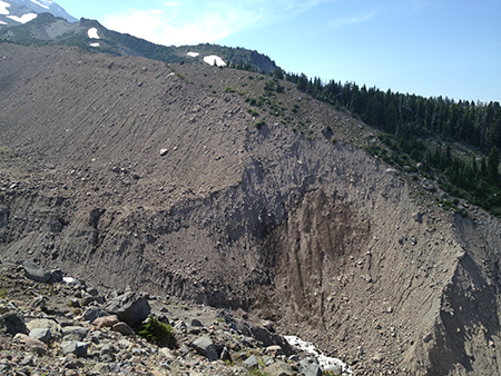
The channel shifts on the White River might seem to be sudden, but in reality, they are perpetual. The White River (along with the rest of Mount Hood’s glacial streams) bring tremendous loads of rock and silt with them. This has always been the case, with melting glaciers releasing debris caught up in the river of ice, some of it building piles of rock called moraines, and some carried off by the rivers that flow from the glaciers.

In the past few decades, the cycle of glacial erosion has been compounded by the retreat of the glaciers, themselves. All of Mount Hood’s glaciers are rapidly losing ice in the face of a warming climate, and the retreat of larger glaciers like the White River, Eliot, Sandy and Coe leaves behind bare ground once covered in ice. 

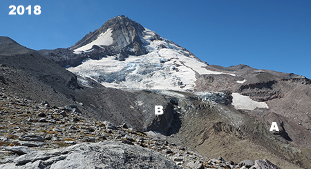
When this happens, and erosion shifts from slow-moving ice to fast-running water, the amount of debris and water moving down the glacial streams grows dramatically. The following diagram (see below) explains this relationship in the context of the rapidly retreating Eliot Glacier, Mount Hood’s largest body of ice, located on the mountain’s northeast side.

[click here for a larger version of this schematic]

Glaciers plow wide, U-shaped valley as they grind away at the mountain, whereas streams cut deep, V-shaped canyons. When glaciers like the Eliot retreat, they expose their u-shaped valleys to stream erosion, and their outflow streams (in this case the Eliot Branch) immediately go to work cutting V-shaped canyons into the soft, newly exposed valley floor, resulting in much more material moving downstream in more volatile events.

In the schematic, the lower part of the Eliot Glacier is somewhat hidden to the casual eye, as it’s covered with rock and glacial till. This is true of most glaciers – the white upper extent marks where they are actively building up more ice with each winter, and the lower, typically debris-covered lower extent is where the ice is actively melting with each season, leaving behind a layer of collected debris that has been carried down in the flowing ice.

The terminus of the glacier in the schematic marks the point where the Eliot Branch flows from the glacier. As the terminus continues to retreat uphill with continued shrinking of the Eliot Glacier, more of the U-shaped glacial valley floor is exposed. At the bottom of the schematic, the floor of the valley has been exposed for long enough to allow the Eliot Branch to already have eroded a sizeable V-shaped canyon in the formerly flat valley. This rapid erosion has fed several debris flows down the Eliot Branch canyon in recent years, including one as recently as this month, abruptly closing the road to Laurance Lake. 

The Eliot Branch continues to spread debris flows across its floodplain, burying trees in as much as 20 feet of rock and gravel. This section of the Eliot Branch flooded again earlier this month, closing the only road to Laurance Lake

We’ve seen plenty of examples of this activity around the mountain over the past couple of decades, too. In 2006 the mountain was especially active, with flooding and debris from the Sandy, Eliot, Newton Clark and White River glaciers doing extensive downstream damage to roads – this was the event that removed the highway at the White River and Newton Creek. Smaller events occurred in 1998, as well. In the 2006 event, the Lolo Pass Road was completely removed near Zigzag and the Middle Fork Hood River (which carries the outflow from the Eliot and Coe glaciers) destroyed bridges and roads in several spots.

Even in quieter times, the White River has moved its channel around steadily. That’s because the heavy debris load in the river eventually settles out when it reaches the floodplain, filling the active river channel. This eventually elevates the river to a point where it spills into older channels or even into other lower terrain. Because of the broad width of the White River floodplain at the base of the mountain, this phenomenon has occurred hundreds of times over the millennia, and the river will continue to make these moves indefinitely. 

To underscore this point, the 2003 highway study of potential solutions for Highway 35 includes this eye-opening chart that shows just how many times the White River has flooded the highway or overtaken the bridges – nearly 20 events since the highway was first completed in 1925!

[click here for a larger version of this timeline]

Therein lies the folly of trying to force the river into a single 100-foot opening (or even a second overflow opening) on a half-mile wide floodplain. The fact that much of the floodplain is devoid of trees is a visual reminder that the river is in control here, and very active. It has a long history of spreading out and moving around that long precedes our era of roads and automobiles.

But the White River has an added twist in its volatility compared to most of the other glacial streams that flow from Mount Hood. The vast maze of sandy canyons that make up the headwaters of the White River are quite new, geologically speaking – at least as they appear today. This is because of a series of volcanic events in the 1780s known as the Old Maid eruptions covered Mount Hood’s south side with a deep blanket of new volcanic debris. The same gentle south slopes that Timberline Lodge and Government Camp sit on today didn’t exist before those eruptions, just 240 years ago.

The White River Glacier (center) flows from near the crater of Mount Hood, and rests upon soft slopes of rock and ash debris that were created by the Old Maid eruptions of the 1780s. The large rock monolith poking up from the crater (left of center) is Crater Rock, an 800-foot lava dome that formed during the Old Maid eruptions

The Old Maid eruptions created other new features on the mountain – notably, 800-foot Crater Rock, a prominent monolith that was pushed up from the south edge of the crater. Meanwhile, the eruptions also generated lahars, the name given to sudden, massive mudflows that can range from ice cold to boiling, depending on the origin of the event. These flows rushed down the White River, Zigzag and Sandy River valleys, burying whole forests under debris ranging from mud and silt to boulders the size of delivery trucks.

The Old Maid eruptions take their name from Old Maid Flat, located along the Sandy River, where a new forest is still struggling to take hold on top of the volcanic debris, more than two centuries later. At the White River, trees buried by the lahars can be seen in the upper canyon, where the river has cut through the Old Maid eruption debris to reveal the former canyon floor, and trees still lying where they were knocked over (more about those buried forests toward the end of this article).

From high on the rim of the White River canyon, the endless supply of rock and ash from the Old Maid deposits is apparent – along with the impossibly tiny (by comparison) “bigger bridge” over the White River

This telephoto view of the new White River bridge from the same vantage point in the upper White River canyon reveals the structure to be a mere speed bump compared to the scale and power of the White River

For this reason, the White River has an especially unstable headwaters area compared to other glaciers on the mountain, with both glacial retreat and the unstable debris from recent lahars triggering repeated flash floods and debris flows here. That’s why the question of whether the new, bigger and bolder highway bridge over the White River will be washed out is more a question of when. It will be, and in our era of rapid climate change, the answer is probably sooner than later.

Is there a better solution? Perhaps simply acknowledging that the river is perpetually on the move, and designing the road with regular reconstruction in mind, as opposed to somehow finding a grand, permanent solution. That’s at odds with the culture of highway building in this country, as it could mean simply accepting more frequent closures and more modest bridge structures – perhaps structures that could even be moved and reused when the river changes course?

The 2003 Federal Highways study actually acknowledges this reality, even if the brawny, costly designs that were ultimately constructed in 2012 do not:

“It is imperative to remember that geological, meteorological, and hydrological processes that result in debris flows, floods, and rock fall have occurred for millions of years, and will occur for millions of years to come. They are naturally occurring phenomena that with current technology cannot be completely stopped or controlled. Thus, the best that can be hoped for is to minimize the destructive, highway– closing impacts of events at the study sites.” (FHWA Highway 35 Feasibility Study, 2003)

The White River seems to be enjoying its new channel and change of scenery…

In the meantime, the newly relocated White River an awesome sight. We’re so accustomed to bending nature to our will in this modern world that it’s refreshing to see a place where nature has no intention of being fenced in (or channeled, in this case). 

Do rivers have a sense of humor or experience joy? As I looked down upon the White River sparkling and splashing down its new channel this summer, it seemed to be thoroughly enjoying the pure freedom of flowing wherever it wants to. It’s yet another reminder that “nature bats last”, and in WyEast country, the mountain – and its rivers — will always have the final word. 

For us, it’s that strangely comforting reminder that we’re quite insignificant in the grand scheme of things, despite our attempts to pretend otherwise.

How to visit the White River

If you’re interested in experiencing the living geology of the White River, an easy introduction is to park at the White River West SnoPark area and trailhead, then head up the trail toward the mountain for a quarter mile or so. From here, the river has moved to the far side of the floodplain, but for the adventurous, it’s cross-country walk across sand and boulders to reach the stream. There, you can soak your feet in ice cold, usually milky water and watch the river moving the mountain in real time, pebble-by-pebble. The main trail is almost always within sight, so it would be tough to get lost in the open terrain here.

Look closely – those tan stripes near the bottom of the White River canyon mark the pre-Old Maid eruption slopes of Mount Hood, now buried under ash and debris from the lahars. Several preserved trees that were knocked down by the eruption can be seen along these margins. This viewpoint is along the Timberline Trail, just east of Timberline Lodge.

To see the relocated White River, park at the White River East SnoPark and walk to the east bridge – now the main crossing of the White River. The view upstream includes the top of Mount Hood, but watch out for speeding traffic when crossing the highway!

To see the buried White River forest, you can park at Timberline Lodge and follow the Timberline Trail (which is also the Pacific Crest Trail here) east for about a mile, where the trail drops to the rim of the upper White River canyon. The views here are spectacular, but if you look directly below for a waterfall on the nearest branch of the White River, you’ll also see the reddish-yellow mark of the former valley floor and the bleached remains of several ghost trees buried in the eruptions 240 years ago. Watch your step, here, and stay on the trail – the canyon rim is unstable and actively eroding!

___________________

Tom Kloster | July 2021

In the Realm of St. Peter

St. Peters Dome rising above the January 13 Bucher Creek debris flow that swept across I-84, killing one person (ODOT)

It seems a world away as we enter yet another summer drought, with record-breaking heat waves and an early wildfire season in WyEast country. Yet, just a few months ago, on January 13th, the tragic story of a Warrendale Resident being swept away in her car by a winter debris flow in the Columbia Gorge filled our local news. The event closed a 10-mile section of I-84 from Ainsworth State Park to Tanner Creek and the area was evacuated after the National Weather Service issued a flash flood warning. 

Some of the local media coverage also connected the dots, reporting on the long history of dangerous debris flows in this part of the Gorge. This was not a freak tragedy, but rather, a completely predictable event. The well-known hazard zone stretches from Ainsworth State Park on the west to Yeon State Park, five miles to the east, encompassing the hamlets of Dodson and Warrendale in its path. While the steep walls throughout the Gorge are infamous for producing rockfall and landslides, this stretch is notoriously active. Why?

Slip-sliding away…

Geoscientists don’t have a particular name for this geologically active area, but the unifying feature is a near-vertical wall that I will call the Nesmith Escarpment for the purpose of this article. The name that comes from Nesmith Point, which has the distinction of being the tallest feature on the Gorge rim, rising nearly 4,000 feet from the banks of Columbia River. The Nesmith Escarpment was largely created by the ancient, catastrophic Missoula Floods that shaped much of what we know as the Columbia River Gorge during the last ice, more than 13,000 years ago. These floods repeatedly scoured the Gorge with torrents hundreds of feet deep, often enough to overtop today’s Crown Point and Rowena Plateau.

Tumalt Creek is the largest of the volatile streams that flow from the towering, over-steepened Gorge walls of the Nesmith Escarpment(ODOT)

As the massive Missoula Floods cut into the slopes below Nesmith Point, the over-steepened terrain began to collapse into the river. It’s a process that continues to this day, gradually expanding the escarpment and leaving behind sheer basalt towers of resistant bedrock along the lower slopes. Of these, St. Peters Dome is the most prominent, along with Rock of Ages and Katanai Rock (the informal name for the impressive monolith that rises just east of St. Peters Dome).

The headwaters of Tumalt Creek flow from the highest walls of the Nesmith Escarpment, where the red, volcanic layers of the Nesmith Volcano that rests on the Gorge rim have been exposed by erosion  (ODOT)

Adding to the geologic uniqueness of the Nesmith Escarpment is Nesmith Point, itself. Located at the top of the escarpment, the familiar layer-cake stack of basalt flows that make up so much of the Gorge geology gives way at Nesmith Point to bright red and yellow layers of clay and cinders that reveal the uppermost part of the escarpment to be the remains of a volcano. The northern half of the volcano has been torn away over the millennia by the growing escarpment, leaving a visible cross-section of the volcanic dome. The surviving, southern half of the Nesmith volcano is gently sloping, like other dome volcanoes that line the Oregon side of the Gorge (the familiar peaks of Larch Mountain and Mount Defiance among them).

[Click here for a large version of the schematic]

The result of all this erosion is a 3-mile-long amphitheater of collapsing layers of volcanic debris and basalt walls resting uncomfortably and over-steepened upon ancient sediments at the base of the cliffs that make for a slippery, unstable foundation. Rain, winter freezes and gravity will therefore continue to chip away at the escarpment for millennia.

Over the many centuries since the Missoula Floods, this relentless erosion has built a huge apron of what geoscientists call an “alluvial fan” at the base of the Nesmith Escarpment. This name describes the flood debris that accumulates where canyon streams prone to flash-flooding suddenly reach a valley floor, slowing and depositing debris over time. The resulting layers typically form a broad, gently sloped wedge shaped like a fan. For the purpose of this article, the fan at the base of the Nesmith Escarpment will be referred to as the Nesmith Fan

(Source: State of Wyoming)

(Source: City of Scottsdale)

One of the defining features of an alluvial fan is the erratic, constantly shifting course of the streams that create them. Because of their shallow slope and the accumulation of debris, these streams continually change course as they spread their loads of rock and gravel on the fan.

If the Nesmith Escarpment and debris fan were located in a desert environment, these defining features would be exposed and easy to see. But in the forested western Gorge, the dense rainforest vegetation quickly covers debris flows with new growth, often within five or ten years, making it hard to recognize how active the geology really is. It’s therefore easy to understand why settlements like Dodson and Warrendale were built upon on the Nesmith Fan, where the fertile ground and gentle terrain were friendly to farming and home sites. The spectacular cliffs of the Nesmith Escarpment simply provided a beautiful backdrop for these communities. Yet, it’s also an increasingly hazardous place for anyone to live.

The image below shows the Nesmith Escarpment and debris fan in a way that wasn’t possible until LIDAR technology was developed. LIDAR allows highly detailed images of topography even in areas like the Gorge, where dense forests cover the terrain. The LIDAR view shows the steep walls of the escarpment in stark relief, including the hundreds of steep ravines that have formed along the escarpment.

Lidar view of the Nesmith Escarpment and debris fan

The LIDAR view also reveals the alluvial deposits that make up the Nesmith Fan to be a series of hundreds (or even thousands) of overlapping debris flows from the roughly dozen streams that flow from the Nesmith Escarpment, each helping to gradually build the enormous alluvial fan. The wrinkled surface of the fan reveals the hundreds of flood channels that have developed over the millennia as countless debris flows have swept down from the cliffs above.

This view (looking east toward Dodson from Ainsworth State Park) shows the vulnerability of I-84 and the Union Pacific Railroad where they cross the 3-mile-wide expanse of the Nesmith Fan. The 2021 debris flows and flooding damage to the Ainsworth interchange can be seen at the center of the photo, where the interstate was temporary closed by the event (ODOT)

[Click here for a large version of this image]

During the very wet winter of 1996, a series of major debris flow roared down from the Nesmith Escarpment, sweeping cars off I-84 and closing the freeway for several days. A train on the Union Pacific line was knocked off its tracks and many home were damaged.

During the event, debris from Leavens Creek, near St. Peters Dome, swept toward the Dodson area, eventually engulfing the Royse house, which was located near the Ainsworth interchange. The scene was shocking, burying the home in debris that rose to the second floor and destroying outbuildings on the Royse farm. You can read Carol Royse’s riveting account of the event on Portland State researcher Kenneth Cruikshank’s excellent web page describing the 1996 debris flows here.

The Royse House in Dodson (with St. Peters Dome beyond) after a series of debris flows on Leavens Creek engulfed the structure in 1996 (The Oregonian)

The Royse home stood half-buried and visible from the freeway for many years, becoming a prominent reminder of the power of the Gorge. By the mid-2000s, a new forest of Red alder and Cottonwood had already enveloped the debris path and the Royse home, eventually obscuring it from view until the Eagle Creek Fire destroyed both the structure and newly established forest in 2017. 

The more recent debris flows in January of this year struck some of the same spots that were impacted in the 1996 and 2001 events. The Tumalt Creek drainage was once again very active, sending debris onto I-84 and closing the freeway. To the west, the Leavens and Bucher creek drainages also sent debris onto the highway and the site of the former Royse home.

As jarring as these changes are to us, this cycle of destruction, rebirth and more destruction has unfolded hundreds of times on the Nesmith Fan. It’s simply part of the ongoing evolution of the landscape.

How do they start?

Debris flows are a mud and rock version of an snow avalanche. They typically begin with oversaturated soils on steep terrain that suddenly liquifies from its own weight. Once it begins to move, the flow can incorporate still more oversaturated soil as it gathers speed, just as a snow avalanche triggers downslope snow to move. The steepness of the terrain is a key factor in how fast a debris flow can move, and on very steep slopes they can reach as much as 100 miles per hour, though they typically slow as the debris reaches the base of the slope and spreads out to form alluvial fans.

These towering twin cascades where Bucher Creek originates along the Nesmith Escarpment rival Multnomah Falls in height. The impossibly steep terrain here is the source of both the debris and sudden flash floods that have helped build the Nesmith Fan, far below (ODOT)

A heavy rain event can also trigger a debris flow by creating stream flooding that erodes and undermines stream banks, causing debris to slide from canyon walls. This form of debris flow is common in the larger canyons in the Columbia Gorge, but less so on the Nesmith Escarpment, where most of the streams are small and only flow seasonally. Here, it’s the steepness of the slopes and the unstable geology that makes the area so prone to debris flows.

Debris flows are different from landslides. A debris flow is typically quite liquid and fast moving, like cake batter being poured into pan. Landslides are typically slow, with a large mass sliding as a whole, like an omelet sliding from a skillet onto a plate. In the Gorge, landslides are common and mostly occur where the underlying geology is oversaturated and allows the overlying terrain to move. The upper walls of the Nesmith Escarpment are scared by hundreds of landslides, and in the right conditions, these slide can trigger debris flows that spread far beyond the landslide.

What about fires and logging?

A third trigger for debris flows is the sudden removal of the forest overstory. The big trees in our Pacific Northwest forests capture and hold a tremendous amount of rain on their surfaces that never reaches the ground, with some of the moisture directly absorbed by the trees and much of it simply evaporating. Clear cut logging removes this buffer, allowing much more precipitation to suddenly reach the soil, triggering erosion, landslides and debris flows. 

Logging roads are especially impactful by cutting into the soil profile on steep slopes and allowing runoff to infiltrate under the soil layer and destabilized soils. This is well-documented as a source of major landslides in heavily logged areas. Thankfully, most of the forested western end of the Gorge is protected from logging, including the Nesmith Escarpment (though early white settlers logged these areas of the Gorge extensively)

The 2017 Eagle Creek Fire has not only destabilized steep slopes throughout the burn by killing the protective forest cover, it also revealed the tortured landscape of braided flood channels on the Nesmith Fan once hidden under dense vegetation. This image from just after the fire shows a volunteer trail crew scouting Trail 400 where it crosses the fan. The route curves in and out of the dozens of channels and debris piles formed by past flood events

Fire can have a similar effect on runoff when the forest canopy is completely killed. This is why new research shows that attempting to log recently burned areas can have serious effects by disturbing newly exposed soils and worsening the increased erosion that would already result from fires.

In the Gorge, the 2017 Eagle Creek Fire burned most of the Nesmith Escarpment, raising serious concerns about the debris flow activity accelerating here in the coming decades. The debris flows earlier this year may have been the first major events to have been triggered as much by deforestation from the fire as by oversaturated soils. The following photo pair shows the extent of the burn on the Nesmith Escarpment, with the first photo taken just a few weeks before the fire in 2017 and the second photo taken in 2018, when the fire’s impact was clearly visible.

The January 2021 debris flow

The Oregon Department of Transportation (ODOT) has been making regular flights over the Eagle Creek Fire burn since late 2017 to monitor for potential flooding and landslides. While the main purpose of these surveys is to anticipate impacts on the highway, ODOT is also amassing an invaluable library of historic photos that document the fire and resulting geologic events in a way that has never been done before.

Their most recent flight includes photos from the January 2021 debris flows that tell the story in a way that words cannot match:

This view looking west toward the Ainsworth Interchange shows how Bucher Creek had completely covered the south half of the interchange and sent mud and debris flowing east on the freeway, itself. The 1996 and 2001 debris flows impacted much of the same area (ODOT)

A closer look at the 2021 debris flows where the Ainsworth interchange was overwhelmed with debris. A green highway sign marks what used to be a freeway on-ramp (ODOT)

Bucher creek briefly pushed the lobe of mud and debris in the lower right of this view directly toward the home in the first photo, before changing direction to the path the creek is following in this photo. This is a good example of how accumulated debris regularly forces the streams that carry the debris into new channels. (ODOT)

This view looking back at the Bucher Creek debris flow lobe shows just how close it came to the home and outbuildings shown in the previous photo (ODOT)

The view down Bucher Creek debris flow toward St. Peters Dome and the Columbia River from near the crest of the Nesmith Escarpment (ODOT)

Landslide in burned timber near the crest of the Nesmith Escarpment. This landslide fed debris directly into the Bucher Creek debris flow, and onto the freeway more than 3,500 feet below (ODOT)

What to do?

It’s tempting to wish away future geologic hazards by taking comfort from what we perceive to be more predictable past. After all, the modern Gorge we know has been evolving for more than 13,000 years, and long periods of slope stabilization have marked recent centuries. But can we count on periods of stability in a future that will be shaped by global climate change? 

Almost surely not. All indications are for more volatility in both weather and flood events like those that have built the Nesmith Fan. Recent evidence increasingly supports the reality that our landscapes are changing along with the climate. In a 2016 report on landslide risks by Multnomah County, the number of events escalated over the past 25 years, including at the Nesmith Escarpment (see table, below).

The best path for adapting to this reality and becoming more resilient in response to future events is to accept the ongoing risk from the Nesmith Escarpment. In the near-term, this means regularly repairing I-84 and the parallel Union Pacific railroad after flood events that will become increasingly common and disruptive. It also means installing early warning systems along these routes for the traveling public and commers, as well as the residents of the area who live in harm’s way. 

The 2021 debris flow along Tumalt Creek during this year’s series of flood events on the Nesmith Fan was a textbook example of why adapting in the near-term to protect existing infrastructure is a tall order. The following images show just how unpredictable and unmanageable this steam has become for ODOT.

Once Tumalt Creek reaches the foot of the Nesmith Escarpment and begins to flow across the fan, its course continually shifts and changes, making it very difficult to predict where each debris flow event might be headed (ODOT)

A single culvert (above) carries Tumalt Creek under the freeway and frontage road, but the Nesmith Fan is a maze of shifting streambeds by definition, making it nearly impossible to force streams to obey culvert locations (ODOT)

The channel carrying the debris flow on Tumalt Creek that overwhelmed the frontage road and I-84 in February later dried up, with the creek shifting to another channel after the flood (ODOT)

This screen was installed at another culvert that Tumalt Creek has swept through in past debris flow eventsl. While this device might keep small debris flows from overwhelming the culvert, it has no chance against the increasingly large debris flows that we can expect on the Nesmith Fan (ODOT)

This is the view from the frontage road looking upstream at the large, main culvert intended for Tumalt Creek – though it had shifted out of the channel when this photo was taken a few months after the February event. The flatness of the terrain on the Nesmith Fan is evident here, with no obvious stream chanel except for the grading and contouring by highway crews (ODOT)

Adapting to a new reality

In the long term, coping with debris flows also means facing some tough questions for those who live on the Nesmith Fan. For some, it’s a place where families have settled for generations. For others, it’s a dream home they’ve put their life savings into on the Columbia River in the heart of the Gorge. But for anyone who lives here, the risks are real and growing – as the death of a local resident in this year’s debris flows reminds us.

Across the country, climate change and rising sea levels are impacting millions of homes and businesses built in floodplains formerly classified as “100-year”, but now seeing regular flooding. In the past, the U.S. Government has provided public flood insurance for those living or operating a business in a flood zone, but the increasing frequency of catastrophic events in flood and hurricane-prone regions like the Mississippi Valley, Texas, Florida and Carolina coasts is pushing federal flood insurance premiums sharply up. This does not bode well for those living and working in hazard zones in the Pacific Northwest, including the rural communities scattered across the Nesmith Fan.

Notices like this will become a way of life for Nesmith Fan residents in coming years

In some places along the Mississippi Valley, the federal government has begun simply relocating homes, and even whole towns, rather than rebuilding them in harm’s way. Could this be a model for the Nesmith Fan? Possibly, though most of the private homes in the path of debris flows are not in the flood plain, and may not be eligible for any form of subsidized federal insurance or assistance, short of a disaster.

A more direct approach that could be taken at the state level is a simple buy-out, over time. Where flood-prone areas in other parts of the country might simply have value as farm or grazing land, the Gorge is a world class scenic area, and both public land agencies and non-profits are actively acquiring land for conservation and public use. As Gorge locations go, it’s hard to find a spot as spectacular as the Nesmith Fan and the escarpment that rises above it.

Already, the Forest Service and Oregon State Parks have acquired land on the Nesmith Fan for recreation and to provide habitat under the Columbia River Gorge National Scenic Area provisions, including at least two parcels with coveted river access. Permanent funding of the federal Land and Water Conservation Fund last year should also help jump-start public acquisitions in the Gorge that have stalled in recent years, and could help spur land owners considering their options.

Katanai Rock (left) and St. Peters Dome (right) rise above orchards at Dodson in this 1940s view from the old Columbia River Highway

Recent events are surely changing the dynamic for landowners in the Gorge, as well. Would some residents living on the Nesmith Fan be more open to a buy-out after witnessing the devastation of last year’s debris flows, knowing that more are likely to come in the wake of the Eagle Creek Fire? Probably. Others – especially the string of luxury homes along the Columbia River – might be more motivated by legacy, and for these folks, non-profit conservation trusts and easements could be a tool for transitioning private land into public ownership over time.

In the meantime, expect more flooding, debris flows and periodic closures of I-84 during the rainy months. And probably more fires in summer, too. This is the new normal in the Realm of St. Peter, after all, and it’s a cycle that will continue for all our lifetimes, and beyond.

A Second Chance and New Vision for Oneonta?

Oneonta Tunnel traffic jam at the west portal shortly after completion in 1916. The highway had not yet been paved when the tunnel opened.

In the span of just about a decade, the Oneonta Tunnel on the Historic Columbia River Highway (HCRH) has endured a wild ride. The tunnel had been closed since the 1940s when the old highway was rerouted around the cliffs of Oneonta Bluff, and for more than half a century lived only in memories and photographs. 

Then, the tunnel was carefully restored to its original glory in 2006 as part of the ongoing effort to restore and reconnect the HCRH. But within just few years, the beautiful restoration work was badly vandalized by uncontrolled mobs of thoughtless young people unleashed upon Oneonta Gorge by social media (see “Let’s Clear the Logjam at Oneonta Gorge). Then, in September 2017, the restored timber lining was completely burned away during the Eagle Creek Fire.

Today, the tunnel stands empty and fenced-off, waiting to be brought back to life, once again. But does it make sense to restore it as before, only to set this historic gem up for more vandalism? Or could it be restored in a different way, as part of a larger vision for protecting the history and natural beauty of both the tunnel and Oneonta Gorge, while also telling the story of the scenic highway, itself? More on that idea in a moment… 

First, a look at how we got here.

Before the dams and after the railroads…

Looking at Oneonta Tunnel today, it’s hard to understand why the original highway alignment went through Oneonta Bluff to begin with, instead of simply going around it? Why wasn’t it simply built in the current alignment of the historic highway, which curves around the bluff? The answer can be seen in this photo (below) taken before the old highway was built.

Oneonta Bluff before construction of the new highway and tunnel in 1916. The new road was squeezed on the uphill side of the railroad line in many spots in the Gorge, forcing creative solutions from the visionary road designer Samuel Lancaster.

It turns out the original railroad alignment crossed Oneonta Creek on a trestle where the current highway is located today, and was also built snug against the base of Oneonta Bluff. Why was it built this way? Because in the era before Bonneville and Grand Coulee dams were completed in the 1930s (along with the many dams in the Columbia basin that followed), the Columbia River fluctuated wildly during spring runoff. So, the original rail line was built to stand above seasonal flood levels of the time.

When Samuel Lancaster assessed the situation in the 1910s, the only options for his new highway were to move the railroad or tunnel through the bluff. As with other spots in the Gorge where the railroads were an obstacle for the new highway, the second option turned out to be the most expedient, and the Oneonta Tunnel was born. 

This close-up look (below) at previous photo shows a man standing on the railroad trestle crossing Oneonta Creek, pointing to what would soon be the west portal to the new tunnel, and I believe this to be Samuel Lancaster on a survey trip — though that’s just my speculation.

Close-up view of what might be Samuel Lancaster pointing at the future west portal at the Oneonta Tunnel site

When the original alignment of the old highway opened in 1916, the new road paralleled the old railroad grade closely, especially east of the tunnel (below), where a retaining wall and wood guardrail separated the somewhat taller road grade from the railroad.

The east portal of Oneonta Tunnel shortly after completion in 1916

Sometime after the original tunnel was built, possibly in the 1930s, the railroad was moved away from the bluff, perhaps because of falling debris from the Oneonta Bluff landing on the tracks, or maybe just part of modernizing the rail line over time. The flood control provided by dams on the Columbia River beginning in the 1930s (and especially the relatively stable “pool” created behind Bonneville Dam) allowed the railroads to move several sections of their tracks in the Gorge onto extensive rock fill during this period, often well into the river, itself. 

This photo (below) from the 1930s shows the west portal of Oneonta Tunnel after the railroad had been move northward, away from Oneonta Bluff, but before the highway had been realigned to bypass the tunnel.

West approach to the Oneonta Tunnel in the late 1930s after the railroad had been moved away from the bluff, opening the door for the highway, itself, to be routed around the bluff

The tunnel at Oneonta Bluff was one of several along the old highway, though it was easily overshadowed as an attraction by the famous “tunnel with windows” at Mitchell Point, to the east and the spectacular “twin tunnels” near Mosier. What made Oneonta Tunnel famous was the view into impossibly narrow Oneonta Gorge, which suddenly appears as you approach the west portal. 

Oneonta Gorge has been a popular tourist attraction since the old highway opened in 1916. For nearly a century, adventurers have waded up the creek to the graceful 120-foot waterfall that falls into Oneonta Gorge, about a mile from the historic highway bridge. Only in recent years has overcrowding presented a serious threat to both the unique cliff ecosystem and the historic highway features here.

Early visitors to Oneonta Gorge in the 1920s

In the 1930 and 1940s, the Oregon Highway Department began a series of projects in the Gorge aimed at “modernizing” the old highway as the dawn of the 1950s freeway-building loomed. A new river-level route was built to bypass the steep climb the original route takes over Crown Point, with the new route following what is today’s I-84 alignment. 

At Tooth Rock (above Bonneville Dam) a new tunnel was blasted through the cliffs to bypass the intricate viaducts built atop the cliffs by Samuel Lancaster. That tunnel still serves eastbound I-84 today, and has become a historic feature in its own right. And at Oneonta Bluff, a new bridge and tunnel bypass (below) took advantage of the relocated railroad, and was completed in 1948.

The (then) new highway bypass bridge under construction in 1948; the original bridge is to the left, and still remains today

When the new bridge and realigned highway section opened, the original bridge Samuel Lancaster built at Oneonta Creek was left in place, thankfully, and it survives today as a elegant viewpoint into Oneonta Gorge and gateway to the tunnel. The Oneonta Tunnel was also decommissioned at the time, with fill at both entrances (below). The tunnel remained this way for the next half-century, as a curiosity for history buffs but forgotten by most.

The realigned historic highway after 1948, with the tunnel (on the right) decommissioned with rock fill at both ends

The rebirth of Oneonta Tunnel began with a bold vision for restoring and reconnecting the surviving sections of the Historic Columbia River Highway as part of the landmark 1986 Columbia River National Scenic Area act, with this simple language: 

16 U.S.C. 544j Section 12. Old Columbia River Highway: The Oregon Department of Transportation shall, in consultation with the Secretary and the Commission, the State of Oregon and the counties and cities in which the Old Columbia River Highway is located, prepare a program and undertake efforts to preserve and restore the continuity and historic integrity of the remaining segments of the Old Columbia River Highway for public use as a Historic Road, including recreation trails to connect intact and usable segments.

And so began what will eventually be a four-decade effort to restore the old highway to its original grandeur, with many beautiful new segments designed as if Samuel Lancaster were still here overseeing the project. Work began elsewhere on the old route in the 1980s, but eventually came to the Oneonta Tunnel in 2006 (below). 

Restoration of the Oneonta Tunnel begins in 2006 (ODOT)

The restoration began with simply excavating the old tunnel, and later rebuilding the stone portals at both ends and installing cedar sheathing to line the interior. A new visitor’s parking area was created outside the east portal and the original white, wooden guardrails were also recreated.

Restored interior wood lining nearly complete in the Oneonta Tunnel in 2006 (ODOT)

For the next few years, the restored tunnel stood as a remarkable tribute to the work of Samuel Lancaster and our commitment to preserving the history of the Gorge. It was a popular stop for visitors and also served as fun part of a hiking loop linking the Horsetail and Oneonta trails.

Vandalism & Oneonta Gorge

Every new technology brings unintended consequences, and the advent of social media over the past two decades has been undeniably hard on our public lands. Where visitors once studied printed field guides and maps to plan their adventures, today’s decisions are more often based on a photo posted in some Facebook group or on Instagram, where hundreds will see it as the place to be right now. 

This has resulted in the “Instagram Effect”, where huge surges in visits follow social media posts, both in the immediate near-term for a given place, and in the long-term interest in hiking and the outdoors. According to a 2017 study by Nielsen Scarborough, hiking in the Pacific Northwest has nearly doubled in popularity the past ten years, with Portland and Seattle ranking second and third (in that order) in the nation for number of hiking enthusiasts — Salt Lake City took the top spot. 

Overall, that’s very good news for our society because hiking and spending time outdoors are good for all of us, and we live in a part of the world where we have some of the most spectacular places to be found anywhere in our own backyard. But the immediate effect of social media can often spell bad news when hordes of ill-equipped and ill-informed people descend upon a place that is trending on their phone.

Social media conga-line waiting to enter Oneonta Gorge in 2016 (Photo: John Speth)
Traffic jam at the Oneonta log jam in 2015 (Photo: TJ Thorne)
Traffic jam at the second Oneonta log jam in 2015 (Photo: TJ Thorne)
Cattle call at Oneonta Gorge in 2015 (Photo: TJ Thorne)

Oneonta Gorge is one of the special places that fell victim to the Instagram Effect, with huge crowds of young people overwhelming the canyon on summer days over the past decade. Sadly, the Forest Service did absolutely nothing to curb the invasion, despite the obvious threat to the rare ecosystem here, and hazardous conditions presented by the infamous log-jam that has blocked the entrance to the canyon since the late 1990s (see “Let’s Clear the Logjam at Oneonta Gorge).

And another unfortunate casualty of this unmanaged overcrowding was the Oneonta Tunnel, itself, when the Oneonta Gorge mobs stopped by to record themselves for posterity in the soft, brand-new cedar walls of the restored tunnel (below). While the vandalism was maddening, the lack of any sort of public response from the Forest Service or ODOT to stem the tide was equally frustrating.

The massive defacing of the restored Oneonta Tunnel interior…
…coincided with the explosive, unmanaged crowds that descended…
…upon Oneonta Gorge in the era of social media…

The vandalism didn’t stop with the destruction of the tunnel walls, however. The unmanaged crowds also tagged spots throughout the area with graffiti, and damaged some of the priceless historic features (below) left for us by Samuel Lancaster.

Damage to historic highway features like this staircase came with the disrespectful mobs of young people coming to Oneonta Gorge over the past decade

As discouraging as the damage at Oneonta was, it was also completely predictable. The idea of limiting access to popular spots in the Gorge is one that the public land managers at the state and federal level have been loath to consider, even when overuse is clearly harming the land and our recreation infrastructure. The problem is made worse by the crazy quilt of intertwined state and federal lands in the Gorge, complicating efforts to manage access, even if the will existed.

Then the fire happened in September 2017, changing everything…

The Fire

When the Eagle Creek Fire was ignited on Labor Day weekend in 2017 by a careless firework tossed from a cliff, few imagined that it would ultimately spread to burn a 25-mile swath of the Oregon side of the Gorge, from Shepperd’s Dell on the west to the slopes of Mount Defiance on the east. In the aftermath, the entire burn zone was closed to the public, and much of it still is. While the fire closure put enormous pressure on the few trails that remained open, it also opened the door to rethinking how we access to trails within the burn zone when they are reopened. How and when that happens remains to be seen.

At Oneonta Bluff, the images of the fire were dramatic and unexpected: the inferno spread to the interior of the restored tunnel and lit up the wood lining, completely burning it away like lit fuse. Local news affiliate KPTV published these views (below) taken by fire crews as the tunnel burned.

East portal view of the Oneonta Tunnel burning in September 2017 (KPTV)
West portal view of the Oneonta Tunnel burning in September 2017 (KPTV)

The Oregon Department of Transportation (ODOT) spent the weeks after the fire in 2017 assessing the damage to the historic highway, including these photos of the burned-out tunnel (below).

West portal view of the Oneonta Tunnel after the fire in 2017 (ODOT)
East portal view of the Oneonta Tunnel after the fire in 2017 (ODOT)

Today, the scene at Oneonta Tunnel hasn’t changed that much. ODOT eventually stripped the remaining, charred timbers from the tunnel and fenced off both portals to the public (below), though vandals have since pushed the fencing aside. The area remains closed indefinitely.

Charred reminders of the fire in 2020 at Oneonta Tunnel
East portal approach to the Oneonta Tunnel in 2020
East portal of the Oneonta Tunnel in 2020
Gated east portal of the Oneonta Tunnel in 2020, opened by vandals

Though it might be heresy to admit, my immediate reaction when I saw the images of the burning tunnel in 2017 was relief. There was no end in sight to the social-media driven vandalism, and the interior had pretty much been ruined at that point, so the fire presented an unexpected opportunity for a redo, someday. Quite literally, it’s an opportunity for Oneonta Tunnel to rise from the ashes, but perhaps in a new way this time.

Remembering what we lost

A new vision for restoring Oneonta Tunnel — and protecting Oneonta Gorge — begins with remembering the fine restoration work completed in 2006. What follows is a look back at what that looked like, before social media took its toll.

At the west portal to the tunnel (where the original Oneonta Bridge, with its graceful arched railings, still stands), the restoration included a gateway sign, restored, painted guardrails built in the style of the original highway and an interpretive display near the tunnel entrance (below). The design functioned as a wide, paved trail, with the idea that cyclists touring the historic highway would pull off the main road and ride through the short tunnel section on a path closed to cars.

West portal of the Oneonta Tunnel in 2008, shortly after the renovation

From the original highway bridge over Oneonta Creek, the view extended into Oneonta Gorge, but also down to this fanciful stairway (below) right out of a Tolkien novel. This feature of the original historic highway continues to take visitors down to the banks of Oneonta Creek (the landing Newell in the bottom center of the photo, at the base of the stairs, is the one broken by vandals in an earlier photo). Just out of view at the top of the stairs is a picturesque bench built into the mossy cliff.

Historic Oneonta Stairwell in 2008

The west portal restoration included new stonework around the timber frame that closely matched the original design (below). 

West portal of the restored Oneonta Tunnel in 2008

Inside, the restored tunnel was lined with cedar plank walls and ceiling, supported by arched beams (below).

Wood interior of the restored Oneonta Tunnel in 2008

The east portal was similar to the west end of the tunnel, with stone masonry trim supporting the portal timbers (below).

East portal of the restored Oneonta Tunnel in 2008

Like the west side, the east entrance approach (below) was designed for cyclists to leave the highway and tour the tunnel and historic bridge before returning to the main road. 

East portal approach to the Oneonta Tunnel in 2008

In practice, most of the traffic in the tunnel before the fire came from hikers and curious visitors parking on the east and west sides and walking the path to the viewpoint into Oneonta Gorge. This is partly because bicycle touring in the Gorge focuses on the extensive car-free-sections of the historic highway, though the shared-road portions of the old highway are expected to see continued growth in cycling as the entirety of the old route is fully restored.

A Fresh Start (and Vision)

Oneonta Gorge in about 1900, more than a decade before the first automobiles would travel through the Columbia River Gorge

The 2006 restoration of Oneonta Tunnel and its approaches was based on the idea of it simply serving as a bicycle and pedestrian path as part of the larger historic highway restoration project. But the tragic defacing of the newly restored tunnel is a painful reminder that it’s simply not safe to assume it will be respected if left open to the public, unprotected, as it was before. Even gates are not enough, as vandals have since demonstrated by tearing open the temporary fencing on the burned-out tunnel.

But what if we considered the tunnel and its paved approaches, including the historic highway bridge, as a useful space instead of a path? The tunnel is surprisingly wide, at 20 feet, and 125 feet long. That’s 2,500 feet of interior space! What if the tunnel were restored this time with the idea of using this as interior space? As a history museum, in fact? With the paved approaches as plazas with outdoor seating, tables and bike parking?

Though it’s not a perfect comparison, there is an excellent model to look to in southern Utah, just east of the town of Kanab, where the privately operated Moqui Cave Natural History Museum is built inside a sandstone cave. The cave was once a speakeasy, then a dance hall in the 1930s, before it was finally converted to become a museum in the 1040s.

Moqui Cave Museum near Kanab, Utah (Wikipedia)

While passing through Kanab on a recent road trip, the stonework blending with the standstone cave entrance at Moqui Cave (below) reminded me of the restored stonework at Oneonta tunnel portals, and how the entrances to the tunnel might be enclosed to create a museum space at Oneonta.

Moqui Cave Museum entrance (TripAdvisor)

Like our Oneonta Tunnel, Moqai Cave is mostly linear in shape (below), with displays of ancient Puebloan artifacts and fossil dinosaur tracks displayed along its sandstone walls.

Moqui Cave Museum interior (TripAdvisor)

These section of the Moqui Cave are roughly the same width and height of the Oneonta Tunnel, with plenty of room for both displays and walking space.

Other solutions for enclosing the entrance at Oneonta Tunnel could draw from our own Timberline Lodge, on Mount Hood. While the stone foundation for the lodge is man-made, it’s not unlike the basalt portals at Oneonta. This is the familiar main entrance on the south side of the lodge (below), showing how the massive wood entry doors are built into the arched stone lodge foundation.

Historic Timberline Lodge entrance door (Wikipedia)

About ten years ago, another entrance to Timberline Lodge was handsomely renovated (below) to become barrier-free, yet still the massive, rugged lodge style that was pioneered here. This updated design shows how modern accessibility requirements could be met at an enclosed Oneonta Tunnel.

Restored Timberline Lodge side entry door (Versatile Wood Products)

There are other examples for enclosing Oneonta Tunnel as a museum space, too. While it would be a departure from Samuel Lancaster original purpose and design to enclose the tunnel, I suspect he would approve, given how the Gorge has changed in the century since he built the original highway.

There are logistics questions, of course. Is the Oneonta Tunnel weatherproof? If the dry floors during winter the months after the 2006 renovation are any indication, than yes, having 150 feet of solid basalt above you provides good weather proofing! Does the tunnel have power? Not yet, but a power source is just across the highway along the railroad corridor. These are among the questions that would have to be answered before the tunnel could be used as a museum, but the potential is promising!

Getting a handle on parking…

One of the most vexing problems along the busy westerly section of the Historic Columbia River Highway is how to manage parking as a means for managing overall crowding. Today, parking is largely unmanaged in this part of the Gorge, which might sound great if you believe there is such a thing as “free parking” (there isn’t). But in practice, it has the opposite effect, with epic traffic jams on weekends and holidays, and travelers waiting wearily for their “free” spot at one of the waterfall pullouts.

Weekend traffic jams on the historic highway are the norm today, and result from unmanaged parking (KATU)

At Oneonta, the lack of managed parking is at the heart of the destruction that mobs descending on Oneonta Gorge brought to the area, including the defacing of the tunnel. Some simple, proven parking management steps are essential, no matter what comes next at Oneonta. First, parking spaces must be marked, with a limited number of spots available and enforced. Can’t find a spot? Come back later, or better yet, at a less crowded time. 

Second, the parking should be managed with time limits (30 minutes, 60 minutes and a some 120 minute spots for Oneonta Gorge explorers). Timed parking also allows for eventual parking fees during peak periods, which in turn, could help pay for badly-needed law enforcement in the Gorge. Eventually, it makes sense to meter all parking spots in the Gorge, but that’s going to take some a level of cooperation between ODOT, the Forest Service and Oregon State Parks that we haven’t seen before, so lots of work lies ahead on that front.

So, these are all basic tools of the trade for managing parking in urban areas, and the traffic in the Gorge is well beyond urban levels. It’s time to begin managing it with that reality in mind.

The east parking area (below) at the Oneonta Tunnel was rebuilt as part of the tunnel restoration in 2006, but is poorly designed, with a huge area dedicated to parallel parking. 

Unmarked, poorly designed shoulder parking at the new pullout east of the Oneonta Tunnel comes complete with a sidewalk, and could be easily be restriped and better managed with angled spaces

However, this relatively new parking area includes a (rarely used) sidewalk, and thus it could be striped with angled spaces that would make for more efficient parking and also include space for a tour bus pullout. ODOT would just need to take a deep breath, since this would involve visitors backing into the travel lane when exiting a spot — a bugaboo for old-school highway engineers. But drivers manage this all time in the city. We can handle it.

The west parking area (below) at Oneonta is an unfortunate free-for all, with an unmanaged shoulder that was ground zero for the huge social media crowds that began clogging Oneonta Gorge in the late 2000s. This area needs a limited number of marked, timed parking spots no matter what happens at Oneonta in the future. There’s also plenty of room for a sidewalk or marked path in front of the parking spaces, along the foot of the cliffs, similar to the new sidewalk built east of the tunnel. This would make for much safer circulation of pedestrians here.

The west parking area would also be the best place for accessible parking spaces, since it offers the shortest, easiest access to the tunnel and views of Oneonta Gorge from the historic bridge.

Looking west for inspiration… and operations?

Most who visit the iconic Vista House at Crown Point don’t know that the interpretive museum inside the building is operated as a partnership between the non-profit Friends of Vista House and Oregon State Parks.

Vista House rotunda (TripAdvisor)

The Friends formed in 1982, well before the Columbia River Gorge Scenic Area was created in 1986, and have done a remarkable job bringing the Vista House back from a serious backlog of needed repairs. Today, it is among the jewels that draw visitors to the Gorge.

Vista House interpretive displays and gift shop (TripAdvisor)

In their partnership with State Parks, the Friends operate a museum inside Vista House, as well as a gift shop and espresso bar in the lower level. Proceeds from the gift shop are directed to their ongoing efforts to preserve and interpret this structure for future generations.

Vista House interpretive displays (TripAdvisor)

The unique partnership between the Friends of Vista House and Oregon State Parks is a proven, successful model, and it could be a foundation for a museum in the restored Oneonta Tunnel. Could the Friends operate a similar facility at Oneonta as part of an expanded mission? Perhaps. Or perhaps another non-profit could be formed as a steward for the tunnel, in partnership with the U.S. Forest Service and State Parks? 

Crucially, having a staffed presence at Oneonta would allow for effectively managing access to Oneonta Gorge, itself, using a timed entry permit system. This is a proven approach to protecting vulnerable natural areas from overuse, and the Forest Service already uses timed permits elsewhere. Ideally, this permitting function would be funded by the Forest Service, and would include interpretive services for other visitors discovering the area, as well.

Focus on Sam Lancaster’s Road?

Samuel Lancaster, the dreamer behind the Columbia River Highway

On the cut stone wall of the Vista House, a bronze plaque honoring Samuel Lancaster provides a very brief introduction to the man. Displays inside Vista House, and elsewhere in the Gorge, also tell his story in shorthand. But Lancaster’s original vision and continued legacy in shaping how we experience the Gorge deserves a more prominent place. A converted Oneonta Tunnel Museum would be a perfect place to tell that story.

The walls of the tunnel provide a combined 250 feet of display space, which could allow visitors to have a detailed look at some of the secrets of Sam Lancaster’s amazing road. The State of Oregon has a rich archive of historical photos of the highway during its construction phase, mostly unseen by the public for lack of a venue. 

These include rare photos of spectacular structures now lost to time. Among these (below) is the soaring bridge at McCord Creek, destroyed to make room for the modern freeway, and the beautiful arched bridge at Hood River, replaced with a modern concrete slab in the 1980s.

The soaring, former McCord Creek Bridge under construction in 1915 (ODOT)
The graceful former Hood River Bridge in the 1920s, replaced with a freeway-style concrete slab in the 1980s (ODOT)

A new Oneonta Tunnel Museum could tell the story of Sam Lancaster’s inspiration for the famous windowed tunnel at Mitchell Point (below), another lost treasure along the old highway destroyed by modern freeway construction.

The former Mitchel Point Tunnel of many windows (ODOT)

A new museum at Oneonta could also tell the story of the surviving gems along the old road that are now part of the Historic Columbia River Highway State Trail. These include (below) the spectacular section between Hood River and Mosier, with its iconic twin tunnels, the beautifully crafted stone bridge at Eagle Creek and the graceful arched bridge at Shepperd’s Dell.

1920s scene along the spectacular Mosier Twin Tunnels section of the old highway
Eagle Creek Bridge construction in 1915 (note the group of stonemasons in the viewing alcove on the left)
Shepperd’s Dell Bridge on dedication day in 1916. Samuel Lancaster is riding in backseat of  the first automobile (photo trivia: the big Douglas fir at the far left in this image is still standing and survived the 2017 Eagle Creek fire with some scorching to its massive trunk!)

The story behind the building of the old highway extends beyond the genius of Samual Lancaster and the beauty of the design. The construction, itself, was a monumental undertaking, and the stories of the people who built this road deserve to be told in a lasting way for future generations.

The Lancaster story continues today, as well. Since the 1980s, ODOT, Oregon State Parks and scores of dedicated volunteers have steered the ongoing effort to restore and reconnect the old route, as called for when the Columbia River Gorge National Scenic Area Actwas signed into law in 1986.

Many of the restoration projects are epic achievements in their own right, and deserve to have their story told for future generations to appreciate. All are inspired in some way by Samuel Lancaster’s original vision for a road blended seamlessly into the Gorge landscape in way that allows visitors to fully immerse themselves in the scenery. These include handsome new bridges (below) at Warren Creek and McCord Creek, as well as a planned recreation of the Mitchell Pont Tunnel.

The new bridge over Warren Creek on the restored Columbia River Highway State Trail
The new bridge over McCord Creek on the restored Columbia River Highway State Trail

What would it take to create an Oneonta Tunnel Museum dedicated to Samuel Lancaster’s enduring vision? Capital funding, of course, but that will surely come at some point, given the current state of the tunnel after the fire. It would also take a willing non-profit partner and a strong interest from the Forest Service, ODOT and Oregon State Parks to try something different when it comes time to once again restore the tunnel. But the time to start that conversation is now, before the agencies start down the path of simply repeating mistakes from the past decade.

So, for now, this is just an idea. But in the meantime, if you’d like to learn more about Samuel Lancaster and his amazing highway, there are two books that should be in every Gorge-lover’s library. And they make for especially good reading in this time in which we’re not able to visit the Gorge! 

The first is Samuel Lancaster’s own book, The Columbia: America’s Great Highway, first published in 1916 by Lancaster, himself. This book is as eccentric and sweeping as Lancaster’s own imagination, and his love for the Gorge comes through in his detailed descriptions of the natural and human history. It’s easy to see how his vision for “designing with nature” grew from his intense interest in the natural landscape of the Gorge.

Lancaster’s original book was reproduced in 2004 by Schiffer as a modern edition, and is still in print. The modern version includes restored, full-color plates from the 1916 edition, as well as additional plates that were added to a 1926 version by Sam Lancaster.

Essential reading for any Gorge lover!

A wonderful bookend to Sam Lancaster’s classic is Building the Columbia River Highway: They Said it Couldn’t Be Done by Oregon author Peg Willis. This exceptional book focuses on the highway, itself, and the collection of characters who came together to make Samuel Lancaster’s bold vision become reality.

Peg’s book also includes a terrific selection of seldom-seen historic photos of the highway during it’s original construction, reproduced with fine quality. In fact, the stories and images in this book would a perfect blueprint for the future Oneonta Tunnel Museum… someday!

_________________

As always, thanks for stopping by and reading through yet another long-form article in our era of tweets and soundbites!

Special thanks to Oregon photographer TJ Thorne, who contributed photos of the Oneonta Gorge summer crowds for this article. Those were just a few snapshots from his iPhone, but please visit TJ’s website to see his amazing fine art nature photography from landscapes across the American West, and please consider supporting his work.

Oregon’s outdoor photographers serve as our eyes on the forest, taking us places we might otherwise never see. They help the rest of us better appreciate and protect our public lands through their dedicated work, but they need our support to continue their work. 

Thanks, TJ!

_________________

Tom Kloster • April 2020

Proposal: Historic Mount Hood Loop Highway State Trail (Part 2 of 2)

Yellow paint still marks the old centerline of an abandoned section of the historic Mount Hood Loop highway, nearly covered with more than 60 years of moss and ferns.

Part 1 of this article introduced the idea of restoring the surviving sections of the old Mount Hood Loop Highway to become part of a world-class cycle tour along this historic route. Part 2 focuses on these surviving historic sections of the old road, from Zigzag on the west side of the mountain to the Sherwood Campground on the east side, and how to bring this vision to reality.

________________

THE CONCEPT

In the near-century since the original Mount Hood Loop was completed in early 1920s, the old route has gradually been replaced with straighter, faster “modern” highways. In areas outside Mount Hood National Forest, the bypassed sections of the old road are mostly still in use, often serving as local roads. But inside the national forest, from Zigzag to Sherwood Campground, long sections of the old road were simply abandoned, left to revert to nature when new, modern roads were built in the 1950s and 60s. Some bypassed sections are still in use, though mostly forgotten.

This is 1930s-era map (below) shows the original alignment of the Mount Hood Loop highway in red and the approximate location of the modern highway alignments of US 26 and OR 35 superimposed in black:

[click here for a large version of this map]

The concept of reconnecting these forgotten sections of historic road is straightforward, building on the example of the Historic Columbia River Highway (HCRH) in the Columbia Gorge. As in the Gorge, places where modern highways on Mount Hood simply abandoned or bypassed the old route, the surviving segments of the old road would be the historic building blocks for creating a new “state trail”, which is simply a paved bicycle and pedestrian path closed to automobiles. 

Sections where the historic route was completely destroyed by modern highways would be reconnected with new trail, like we see in the Gorge, or with protected shoulder lanes on quiet sections of the modern highway in a couple areas.

This map shows the overall concept for restoring the route as the Historic Mount Hood Loop State Trail:

[click here for the 11×17″ JPG version]

[click here for the 11×17″ PDF version]

Segments shown in blue on the concept map are where bypassed sections of the old highway still survive and segments shown in red are where new trails would connect the surviving historic segments. All of the new trail sections are proposed to follow existing forest roads to minimize costs and impacts on the forest. 

The concept map also shows several trailheads along the route where visitors would not only use to access the trail, but would also have trail information and toilets. These trailheads already exist in most cases, with several functioning as winter SnoParks that could be used year-round as part of the new trail concept.

Six Forest Service campgrounds (Tollgate, Camp Creek, Still Creek, Trillium Lake, Robinhood and Sherwood) already exist along the proposed route and two long-forgotten campgrounds (Twin Bridges and Hood River Meadows) are still intact and could easily be reopened as bikepacking-only destinations.

EXPLORING THE ROUTE

The next part of this article explores the scenic and historic highlights of the historic highway in three sections, from Rhododendron on the west side of the mountain to the Sherwood Campground and East Fork Hood River on the east side.

West Section – Rhododendron to Government Camp

The historic bridge over the Little Zigzag River survives, marking the beginning of a gracefully, winding ascent of Laurel Hill along the old loop highway

Beginning at the tiny mountain community of Zigzag, it’s possible to follow a couple bypassed segments of the old loop highway, notably along Faubion Road, but most of this section would follow a new, protected path on US 26 to Rhododendron, where the off-high trail concept begins. 

Part 1 of this article outlined the economic benefits of cycle touring, and by anchoring the west end of the new trail in Rhododendron, this small community would benefit from tourism in a way that speeding winter ski traffic simply doesn’t offer. The gateway trailhead would be located at the east end of Rhododendron, connecting to the Tollgate Campground, the first camping opportunity along the proposed route

The Barlow Road Tollgate near Rhododendron in the 1880s

From Tollgate, the new route would follow the Pioneer Bridle Trail for the next two miles to the Kiwanis Camp Road junction, on US 26. This is a lightly used section of the Pioneer Bridle Trail, which was built by the Civilian Conservation Corps from Tollgate to Government Camp in the 1930s. This part of the corridor follows the relatively flat valley floor of the Zigzag River, so there is plenty of room for a new trail to run parallel to the Pioneer Bridle Trail, as another option.

Pioneer Bridle Trail east of Tollgate

Once at the Kiwanis Camp Road junction, the new route would share this quiet forest road for the next next couple miles. Kiwanis Camp Road is actually a renamed, surviving section of the old highway and still provides access to the Paradise Park and Hidden Lake trails into the Mount Hood Wilderness. 

The Zigzag River passing through the old Twin Bridges campground site

Along the way, this section of old highway passes the site of the long-abandoned Twin Bridges campground, where a surviving bridge also forms the trailhead for the Paradise Park Trail. This shady old campground is quite beautiful, with the rushing Zigzag River passing through it. It could easily be reopened as a bikepacking-only camping spot along the tour.

Little Zigzag Falls

This operating section of old highway soon ends at the Little Zigzag River and the short spur trail to pretty Little Zigzag Falls. The enormous turnaround here once served as a rock quarry for the original loop highway, and has plenty of room serve as trailhead for the new state trail

From here, the old road begins an ascent of Laurel Hill, one of the most scenic and fascinating sections of the old highway. Large boulders now block the old highway at the historic bridge that crosses the Little Zigzag River, and from there, an abandoned section of the old road begins the traverse of Laurel Hill.

Abandoned historic highway section near the Little Zigzag crossing

This abandoned section of historic road crosses the upper portion of the Pioneer Bridle Trail where an unusual horse tunnel was constructed under the old highway as part of creating the Bridle Trail. It’s hard to imagine enough highway traffic in the 1930s to warrant this structure, but perhaps the trail builders were concerned about speeding Model As surprising visitors crossing the road on horseback? Whatever the reason, the stone bridge/tunnel structure is one of the many surviving gems hidden along the old highway corridor.

Pioneer Bridle Trail tunnel under an abandoned section of the historic loop highway

From the Pioneer Bridle tunnel overcrossing, the old road soon dead-ends at a tall embankment, where modern US 26 cuts across the historic route. The spot where the modern highway was built was once one of the most photographed waysides along the old highway, appearing in dozens of postcards and travel brochures. It was the first good view of the mountain from the old highway as it ascended from the floor of the Zigzag Valley to Government Camp (below).

While much of the old road has survived, the modern alignment of US 26 cut through this spot on the old loop, creating one of two gaps on Laurel Hill that will require significant structures to reconnect

Although almost all of the old highway survives where it climbs the Laurel Hill grade, this spot marks one of the two major gaps along the way that would require a significant new structure to reconnect the route. A second gap occurs at the crest of Laurel Hill, to the east, where the modern highway cuts deeply through the mountain. This map shows the surviving, abandoned sections of the historic highway along the Laurel Hill grade and upper and lower gaps that must be bridged:

[click here for a large version of this map]

On the ground, the lower Laurel Hill gap looks like this:

The lower Laurel Hill gap is at a well-known spot where a history marker points toward a short trail to one of the Barlow Road “chutes” that white migrants on the Oregon Trail endured in their final push to the Willamette Valley. 

ODOT has made this section of highway much faster and more freeway-like in recent years in the name of “safety”, but in the process made it impossible for hikers to cross the highway from the Pioneer Bridge Trail to visit the Barlow Road chute. A freeway-style median now blocks anyone from simply walking across the highway and cyclone fences have been added to the north side to make sure hikers get the message.

Given this reality, both of the Laurel Hill gaps would be great candidates for major new crossings, along the lines of work ODOT has done in the Gorge to reconnect the HCRH. This viaduct (below) was recently built by ODOT at Summit Creek, on the east side of Shellrock Mountain, where the modern I-84 alignment similarly took a bite out of an inclined section of the old highway, leaving a 40-foot drop-off where the old road once contoured downhill. This sort of solution could work at the lower Laurel Hill gap, too.

This new bicycle and pedestrian viaduct reconnects surviving segments of the original highway near Summit Creek along the Historic Columbia River Highway State Trail.

Beyond the Laurel Hill history marker on the south side of the modern US 26, a set of 1950s stone steps (below) leads occasional visitors up to the next section of abandoned Mount Hood Loop highway, where the old route continues its steady climb of Laurel Hill.

Stone steps leading from US 26 to the Barlow Road “chute” on Laurel Hill

This section of the abandoned route is in remarkably good shape, despite more than 60 years of no maintenance, whatsoever. It also briefly serves as the trail to a viewpoint of the Barlow Road chute — a footpath to the top of the chute resumes on the opposite side of the old highway, about 100 yards from the stone steps.

Abandoned section of the loop highway near the Barlow Road chute

When the historic highway was built in the 1920s, the Barlow Road was still clearly visible and only a few decades old. Despite the care they used elsewhere to build the scenic new road in concert with the landscape, there was no care given to preserving the old Barlow Road. Thus, the historic highway cut directly across the chute, permanently removing a piece of Oregon history. 

Today, the footpath to the top of the chute still gives a good sense of just how daunting this part of the journey was (below). This short spur trail, and others like it along the surviving sections of the old highway, would be integrated into the restored Mount Hood Loop route, providing side attractions for cyclists and hikers to explore along the way.

Looking down the Barlow Road chute from the interpretive trail

Beyond the Barlow chute, the old highway enters a very lush section of forest, where foot traffic from explorers continues to keep a section of old pavement bare (below). Scratch the surface, and even under this much understory, the old highway continues to be in very good condition and could easily be restored in the same way old sections of highway in the Gorge have been brought back to life as a trail.

Abandoned section of the old loop highway near Yocum Falls

Some of the foot traffic along the abandoned Laurel Hill section of the old loop road is headed toward a little-known user path that drops steeply down to Yocum Falls, on Camp Creek. This is a lovely spot that deserves a proper trail someday, and would make an excellent family destination, much as the Little Zigzag Falls trail is today.

Yocum Falls is mostly forgotten since the construction of the modern highway, but remains as beautiful as when it was featured on postcards in the 1920s

Yocum Falls was once well known, as the full extent of this multi-tiered cascade could be seen from along the old highway. As this old postcard from the 1920s shows (below), Camp Creek also served as a fire break for the Sherar Burn, which encompassed much of the area south of today’s US 26 in the early 1900s. You can see burned forest on the south (right) side in this photo and surviving forest on the north (left) side:

Yocum Falls in a 1920s postcard view from the original Mount Hood Loop Highway

The fire also created this temporary view of the falls in the early 1900s, but the forest has since recovered and obscured the view. Today, the short hike down to the falls on the user path is required for a front-row view of Yocum Falls.

Beyond the falls, the abandoned highway makes a pronounced switchback and begins a traverse toward the crest of Laurel Hill. Here, the vegetation becomes more open, and road surface more visible (below).

Abandoned section of the old highway as it approaches the crest of Laurel Hill

Soon this abandoned section of old road makes another turn, this time onto the crest of Laurel Hill. When the historic highway was built, this stretch was still recovering from the Sherar Burn, and the summit was dense with rhododendron and beargrass that put on an annual flower show each June. This was perhaps the most iconic stop along the old route, appearing on countless postcards, calendars and print ads (below).

1940s tourism ad featuring the (then) famous view of Mount Hood from Laurel Hill

Today, most of this section has reforested, but there are still views of the mountain and opportunities for new viewpoints that could match what those Model A drivers experienced in the early days of touring on Mount Hood.

Soon, this abandoned section of old road on Laurel Hill reaches the upper gap, where ODOT has recently made the yawning cut through the crest of the hill even wider. This schematic is a view of the cut looking north (toward the mountain), with the stubs of the historic highway shown: 

If there is any good news here, it is that the modern highway cut is perpendicular to the old loop highway, making it possible to directly connect the surviving sections of the old road with a new bridge. This view (below) is from the eastern stub of the old route, where it suddenly arrives at the modern highway cut. The stub on west side of the cut is plainly visible across US 26:

This panoramic view (below) from the same spot gives a better sense of the gap and the opportunity to bride the upper Laurel Hill gap as part of restoring the old route as a trail. A bonus of bridging the upper gap would be an exceptional view of Mount Hood, which fills the northern skyline from here.

The upper gap is about 250 feet across and 40 feet deep, so are there any local examples of a bridge that could span this? One historic example is the old Moffett Creek Bridge on the HCRH, pictured below while it was being constructed in 1916. This bridge measures about 200 feet in length with a single arch.

Moffett Creek Bridge construction along the Columbia River Highway in 1916

The City of Portland recently broke ground on the new Earl Blumenauer Bridge, a bicycle and pedestrian crossing over Sullivan’s Gulch (and I-84) in Portland. This very modern design (below) might not be the best look for restoring a historic route on Mount Hood, but at 475 feet in length, this $13.7 million structure does give a sense of what it would take to span the upper gap at Laurel Hill. 

The City of Portland recently broke ground for this new bicycle and pedestrian bridge over Sullivan’s Gulch, linking the Lloyd District to Portland’s Central Eastside (City of Portland)

That sounds like a big price tag, but consider that ODOT recently spent three times that amountsimply to add a lane and build a concrete median on the Laurel Hill section of US 26. It’s more about priorities and a vision for restoring the old road than available highway funding. More about that in a moment.

Moving east from the upper Laurel Hill gap, the abandoned section of the old highway continues (below) toward Government Camp, eventually reaching the Glacier View trailhead, where the surviving old highway now serves as the access road to this popular, but cramped, SnoPark.

Abandoned section of the loop highway near Government Camp

Sadly, the Forest Service recently destroyed a portion of the abandoned loop highway just west of the Glacier View trailhead, leaving heaps of senselessly plowed-up pavement behind. While destroying this section of historic road was frustrating (and possibly illegal), it can still be restored fairly easily. But this regrettable episode was another reminder of the vulnerability of the old highway without a plan to preserve and restore it.

Piles of paving line a short section of the abandoned loop highway near Government Camp where the Forest Service recently destroyed the road surface with no consideration of its historic value — a senseless reminder of the vulnerability of this precious route

From the Glacier View trailhead, the old road become an operating roadway once again, curving south to another junction with US 26, across from the new Mirror Lake trailhead, where a major new recreation site completed in 2018. This trailhead provides parking, restrooms and interpretive displays for visitors to the popular Mirror Lake trail, and is immediately adjacent to the Mount Hood Ski Bowl resort and lodge.

Plans call for a new bicycle and pedestrian bridge over US 26 at the Mirror Lake trailhead, spanning one of the critical gaps necessary to reconnect the old highway route

Crossing the US 26 at this junction is a sketchy, scary experience, especially on foot or a bicycle. Fortunately, the 2014 Mount Hood Multimodal Plan, adopted jointly by the Forest Service and ODOT, calls for a major bicycle and pedestrian bridge here to allow for safe crossing by hikers, cyclists, skiers and snowshoers, so a plan is already in place to resolve this obstacle.

Middle Section – Government Camp to Barlow Pass

Mount Hood mirrored in one of the ponds at Multorpor Fen (State of Oregon)

From the Mirror Lake trailhead, the old highway loops through today’s parking lot at the Mount Hood Ski Bowl resort, then crosses US 26 again to loop through the mountain village of Government Camp. These graceful curves in the old route were bisected when the modern US 26 was built in the 1950s, leaving them intact as local access roads. However, because the Government Camp section of the old road serves as the village main street, the concept for a Mount Hood Loop Highway State Trail parallels the south edge of US 26 along a proposed new trail section, and avoids two crossings of the modern highway in the process. 

However, a more interesting (but complicated) option in this area is possible along the south edge of the Multorpor Fen, an intricate network of ponds, bogs and meadows sandwiched between the east and west Mount Hood Ski Bowl resort units. The remarkable view in the photo above shows one of the ponds along this alternate route, far enough from the modern highway to make traffic noise a distant hum. However, this route would also require crossing a section of private land at Ski Bowl East. The mountain views and buffer from the highway make this an option worth considering, nonetheless.

Both options are shown on the concept map at the top of this article, and either route through the Government Camp area leads to the northern foot of Multorpor Mountain, where the concept for the state trail is to repurpose a combination of existing and abandoned forest roads as new trail to historic Summit Meadow and popular Trillium Lake, where the second and third campgrounds along the proposed trail are located.

Historic Summit Meadow, a crucial resting spot for white Oregon Trail migrants in the 1840s along the old Barlow Road
Mount Hood from Trillium Lake

From Trillium Lake, the new trail would follow existing forest roads toward Red Top Meadow, to the east, then follow a new route for about a mile to the continuation of the historic loop highway, just east of the US 26/OR 35 junction. Here, a surviving section of the old road is maintained and remains open to the public, passing the mysterious Pioneer Woman’s Grave site as it climbs toward Barlow Pass. 

Surviving section of the old loop highway near Barlow Pass that is still open for use
This massive, carved history marker once stood at the Pioneer Woman’s Grave along the old loop highway, near Barlow Pass
The badly neglected Pioneer Woman’s Grave site today

When the original highway was completed in the 1920s, a viewpoint along this section of the road was called “Buzzard Point” and inspired postcards and calendar photos in its day. Few call this spot Buzzard Point anymore, but the view survives, along with a rustic roadside fountain built of native stone and still carrying spring water to the passing public. In winter, this section of the old road is also popular with skiers and snowshoers.

This 1920s view from Buzzard Point was well-known in the heyday of the old loop highway
This surviving stone water fountain near Buzzard Point is still flowing nearly a century after it was built!

This section of the old route continues another mile or so to the large SnoPark at Barlow Pass, another important trailhead that serves both the loop highway corridor and the Pacific Crest Trail.

East Section – Barlow Pass to Sherwood Campground

Barlow Road history sign at the Barlow Pass trailhead, where the Pacific Crest Trail crosses the historic loop highway

From Barlow Pass, the trail concept calls for a protected bikeway on the shoulder of OR 35, where it crosses the White River and climbs to Bennett Pass. It would be possible for the trail to take a different route along this section, but the traffic volumes and speed on OR 35 are much less intimidating than those on US 26, especially from spring through fall, when ski resort traffic all but disappears. There is also plenty of room to add protected bike lanes along this section of OR 35, including on the new bridge over the White River that was completed just a few years ago.

The Mount Hood Loop trail concept would follow this section of OR 35 as a protected bikeway from Barlow Pass to the White River and Bennett Pass
The White River crossing has always been a popular stop along the Mount Hood Loop Highway. In the early days, motorists could stop here to picnic and pick up souvenirs at “White River Park”
The White River is a notoriously wild glacial stream that has a long history of washing out the loop highway bridges — this was the first bridge to span the river as it appeared in the 1920s
This is a 1930s version of the White River Bridge, one still constructed of logs and planks
Franklin and Eleanor Roosevelt stopped at the White River crossing in 1937 on their famous tour of the Mount Hood Loop Highway and dedication of Timberline Lodge

Upon reaching Bennett Pass, the proposed route would once again follow an especially scenic section of bypassed historic highway, with views of waterfalls, alpine meadows and the mountain towering above.

Mount Hood from the original Mount Hood Loop Highway at Bennett Pass in the 1930s
1950s view of the Mount Hood Loop Highway at Bennett Pass before the modern highway was constructed

Of the many scenes along the old road that were postcard favorites, the view of the Sahalie Falls Bridge, stone fountain and falls in the background was among the most popular. The bridge was the largest structure on the original loop highway, and a scenic highlight (you can read more about the history of the bridge in this 2013 blog article “Restoring the Sahalie Falls Bridge”)

The graceful Sahalie Falls bridge is the architectural highlight of the old loop highway, and was restored in 2013
The Sahalie Falls Bridge under construction in the 1920s
Popular postcard view of the Sahalie Falls Bridge and stone fountain from the 1920s

Today, the bridge is once again in excellent condition, having been restored by the Federal Highway Administration in 2013. For years, the bridge had been closed to automobiles because of its state of disrepair, but today it stands as perhaps the most significant historic highway feature along the old road.

From Sahalie Falls, the historic road curves east through subalpine forests before arriving at Hood River Meadows, among the largest on Mount Hood and another spot that was featured in countless postcards and advertisements during the heyday of the old road. 

1920s view of the old loop highway at Hood River Meadows. This nearly forgotten section of the old highway still operates today.

The long-abandoned Hood River Meadows campground also survives here, along the east side of the meadows, and is still in excellent condition. This site could be reopened as a second bikepacking-only camping spot along the proposed trail. 

1940s tourism ad featuring Mount Hood from the loop highway at Hood River Meadows

Next, the historic road curves toward OR 35 where it also serves as the resort access road for the Hood River Meadows ski complex. From the spot where the old road meets OR 35, there are a couple more abandoned road sections along the north edge of OR 35 that could be reconnected as part of the Loop Highway trail concept, but this is the last of the surviving sections of the old road on this part of the mountain.

From here, the trail concept would connect a series of old forest roads on a gradual descent of the East Fork Hood River valley, toward Sherwood Campground, located along the East Fork, and completing the Mount Hood Loop Highway State Trail.

East Fork Hood River near Sherwood Campground in winter

Sherwood Campground is a very old, still operating campground that includes another stone fountain from the old highway, located near the campground entrance. The campground is also a jumping off point for the popular trail to Tamanawas Falls. Nearby Little John SnoPark would serve as the main eastern trailhead for the new trail, with a short connecting route the main trail. 

Historic stone fountain from the original loop Highway at Sherwood Campground
Tamanawas Falls, just off the loop highway near Sherwood Campground

Sherwood Campground would form the eastern terminus of the historic section of the proposed Loop Highway State Trail. From here the larger Mount Hood scenic loop route would follow OR 35 through the narrowing canyon of the East Fork to the wide expanse of the upper Hood River Valley. 

This narrow section of the loop highway is where a safe, protected bikeway will need to thread the needle between cliffs and the East Fork Hood River

The canyon section along the East Fork is a crux segment for the loop route, with the modern highway wedged between the river and a wall of steep cliffs and talus slopes. Engineers designing a safe bikeway through this section of road could take some inspiration from the Shellrock Mountain in the Gorge, where the HCRH State Trail threads a similar corridor between I-84 and the talus slopes of Shellrock Mountain. This crux section along the East Fork is about a mile long.

WHERE TO START?

Touring the upper Hood River Valley in the 1950s

What would it take for this concept to become a reality? A crucial first step would be a feasibility study inspired by the HCRH State Trail, with an emphasis on the potential this example offers for restoring and reconnecting historic sections of the old Mount Hood Loop Highway on Mount Hood. 

Rock crusher along the original loop highway during its construction in the 1920s

An obvious sponsor for this work would be the Oregon Department of Transportation, working in partnership with the U.S. Forest Service. These agencies have worked together to bring the Historic Columbia River Highway State Trail to reality and have both the experience and capacity to repeat this success story on Mount Hood. The following outline could be a starting point for their work:

Mount Hood Loop Highway State Trail Feasibility Study 

Purpose Statement

Restore and reconnect surviving sections of the historic Mount Hood Loop Highway from Rhododendron to Sherwood Campground as a paved state trail the combines shared right-of-way and non-motorized trail experiences.

Feasibility Study Objectives

  • Identify new, paved trail segments needed on public land to complete the loop using existing forest road alignments whenever possible.
  • Identify surviving historic resources and new interpretive opportunities along the trail.
  • Identify multimodal trailhead portals at the trail termini and at major destinations along the trail, including Rhododendron and Government Camp.
  • Identify bike-and-hike opportunities that build on soft-trail access from a new, paved state trail.
  • Coordinate and correlate route and design options and opportunities with the 2014 Mount Hood Multimodal Transportation Planand the Mount Hood Scenic Byway Interpretive Plan and Design Guidelines.
  • Identify an alternate bicycle route for the Mount Hood Scenic Byway from Sandy to Rhododendron that does not follow the US 26 shoulder.
  • Identify design solutions for designing a protected shoulder bikeway in the crux section of OR 35 in the East Fork canyon.
  • Engage public and private stakeholders and the general public in developing the feasibility study.

But what would it really take..?

Railing and sidewalk repairs underway to the historic Sahalie Falls Bridge in 2013

While ODOT has directly managed construction of the HCRH State Trail in the Gorge, a lesser-known federal agency has been taking the lead in recent, similar projects on Mount Hood. A little-known division of the Federal Highway Administration known as Federal Lands Highway is gaining a growing reputation for innovative, sustainable designs in recent projects on our federal public lands. 

On Mount Hood, Federal Lands Highway oversaw the restoration of the Sahalie Falls Bridge in 2013, a long-overdue project that rescued this priceless structure from the brink of oblivion. Like any highway agency, they excelled at the roadway element of the project, like restoring the bridge and related structure. Other opportunities were missed, however, including improving the adjacent parking areas and providing interpretive amenities for visitors. 

Forms for new railing caps on the Sahalie Falls Bridge in 2013
Federal Lands Highway rebuilt the footing for the historic water fountain at Sahalie Falls as part of the bridge restoration project
The newly restored Sahalie Falls Bridge and fountain in 2014

Federal Lands Highway also completed a major reconstruction of OR 35 at Newton Creek in 2012. This project was in response to massive flooding of this surprisingly powerful glacial stream in 2006. Their work here shows some of the negatives of a highway agency taking the lead, with a very large footprint on the land and a big visual impact with over-the-top, freeway-style “safety” features that are old-school by today’s design practices.

The mega-culvert project built by Federal Lands Highway at Newton Creek in 2012

In 2012, Federal Lands Highway also completed (yet another!) bridge replacement over the White River, which was also damaged in the 2006 floods. The massive new bridge is similarly over-the-top to their work at Newton Creek, but Federal Lands Highway deserves credit for rustic design features that blend the structure with the surroundings, including native stone facing on the bridge abutments.

Western Federal Lands completed the new White River Bridge in 2012

The most promising recent work on Mount Hood by Federal Lands Highway is the completion of the new Mirror Lake Trailhead in 2018. This project involved a significant planning effort in a complex location with multiple design alternatives. Their work here involved the public, too, something their earlier work at White River, Sahalie Falls and Newton Creek neglected.

The new Mirror Lake Trailhead was completed in a partnership of Federal Lands Highway, the Forest Service and ODOT in 2018

The final result at Mirror Lake is an overall success, despite the controversy of moving the trailhead to begin with. The new trailhead is now a prototype of what other trailheads along a restored Mount Hood Loop Highway State Trailcould (and should) look like, complete with restrooms, interpretive signs, bicycle parking and accessibility for people using mobility devices.

New shoulder swales along US 26 were part of the Mirror Lake trailhead project, helping to protect water quality of Camp Creek from highway runoff
The new Mirror Lake Trailhead plaza includes restrooms, interpretive signage, bike parking and seating for visitors

Beyond the hardscape features at the new trailhead, Federal Lands Highways worked with the Forest Service to replant areas along a new paved section of trail. This work provides another useful template for how the two federal agencies could work together with ODOT in a larger restoration of the old Loop Highway as a new trail.

Though it looks a little rough, this area along the new, paved section of the Mirror Lake Trail was landscaped with native materials as part of the new trailhead project
Landscape restoration at the new trailhead included woody forest debris, native understory starts and hydro-seeding to protect newly planted areas from erosion

One of the compelling reason for Federal Lands Highway to take a leading role in a Loop Highway trail project is the unfortunate fact that ODOT has ceded the right-of-way for several of the abandoned sections of the old road to the Forest Service. This would make it difficult for ODOT to use state funds to restore these sections without a federal transportation partner like Federal Lands Highway helping to navigate these jurisdictional hurdles. 

However, governance hurdles like this existed in the Gorge, too, and state and federal partners simply worked together to resolve them, provided they had a clear mandate to work toward.

Getting behind the idea… and creating a mandate

The original Mount Hood Loop Highway in the Hood River Valley in the 1930s

Bringing this trail concept to reality will take more than a feasibility study, of course — and even that small step will take some political lifting by local officials, cycling advocates, the local tourism community and even our congressional delegation. While the money is clearly there for ODOT to begin this work, it would only happen with enough political support to begin the work.

The good news is that Oregon’s congressional delegation is increasingly interested in outdoor recreation and our tourism economy, especially when where a coalition of advocates and local officials share a common vision. With the HCRH State Trail in the Gorge nearing completion after more than 30 years of dedicated effort by advocates and ODOT, it’s a good time to consider completing the old loop as the next logical step in restoring a part of our legacy.

The idea of loop around Mount Hood began as soon as the Columbia River Highway was completed in 1915. This article in The Oregon described the first documented trip around the mountain using a patchwork of roads that existed before the Mount Hood Loop was constructed in the 1920s (large PDF versions of this article can be viewed at the links, below)

1915 Article – Page 1 (PDF)

1915 Article – Page 2 (PDF)

Rumor has it that new legislation is in the works to ramp up protection and improve recreation opportunities for Mount Hood and the Gorge. Including theMount Hood Loop Highway State Trail concept in new legislation would be an excellent catalyst for moving this idea from dream to reality. 

But could this really happen in today’s fraught political environment in Washington D.C.? Don’t rule it out: President Reagan was notorious for his hostility toward public lands, and yet he infamously “held his nose” and signed the Columbia River Gorge legislation into law in 1986, including the mandate to devise a plan to restore surviving sections of the HCRH as a trail. 

So, could this happen in the era of Trump for Mount Hood? Stay tuned…

WyEast Blog at 10 years! (and counting!)

00_2018DufurMillRoadHoodFramed

First snow of autumn 2018 on Mount Hood as seen from Dufur Mill Road

Last November marked 10 years since I started the WyEast Blog, way back in 2008. It was a pretty hopeful year, as you may recall, followed by some very progressive reforms for how our public lands are managed.  And my, how things can change — elections do have consequences! So, as always, the work continues as we weather another round of political attacks on our hard-fought protections for public lands.

Much has changed in WyEast country over the past 10 years, too, but certainly not my commitment to a better future for Mount Hood and the Columbia River Gorge. I’m frequently asked “do you reallythink Mount Hood will become a national park?” and my response is always the same, “a little more every day!”Why? Because despite the currently bleak situation in Washington D.C., we’re (finally) witnessing the start to a changing of the guard in generational leadership at all levels of our society. The Millennials are here!

01_TomEagleCreek

Author on my last visit to Eagle Creek, about a year before the September 2017 fire

What will history say about the Baby Boomers as they (reluctantly) hand over the reins to a younger generation? For all they have given us in their epic contributions to art and culture, they have also been surprisingly awful when it comes to conservation, woefully lacking in both courage and imagination. It’s true the Millennials are overdue in taking the reins, but since twice delivering the first African American to the U.S. presidency (a man who the Boomers voted overwhelmingly against, history shall note), they have steadily expanded their presence on the local, state and national political scenes. The 2016 elections represented the beginning of what will become a tidal wave in coming years, too.

By wide margins, Millennials are genuinely committed to conservation and sustainability, more balanced in their personal lives in how they manage ambition and status, and much less materialistic and consumptive than their elders. The numbers prove this. And thus my confidence that the Millennials’ turn at governance can (and will) return us to the bold conservation legacy of past eras and previous generations of leadership. The pendulum will swing, once again, and I believe that expanding our national park system will be part of that renaissance.

In the beginning…

Ten years ago, I started this blog with a rather obscure look at a couple of dead trees at a favorite roadside viewpoint of mine, along Dufur Mill Road. Here’s what that spot used to look like:

02_2008DufurMillRoad

The two snags featured in the very first article on this blog… but what about the big fir on the right?

Sometime that year, both snags on the left side of the photo were felled, possibly for firewood, a common activity in that area. At the time I was dismayed at the senseless loss of a couple of valauble and (to me) beautiful snags. Mount Hood’s old ghost trees are essential for wildlife and forest health, after all! And thus, my first article began what would become many looks at the lesser-known and under-appreciated corners of WyEast country, all in celebration of our magical mountain and gorge!

Today, the view from this spot on Dufur Mill Road is still much the same, minus the old snags. Here’s what it looked like a couple of weeks ago (below), where you can pick out individual trees in the background that appear much the same. The large Douglas fir on the right side of the original photo still stands, too, but what about the apparent change in height of this tree between the above and below photos?

03_2018DufurMillRoad01

Today the two snags are long gone, but the big Douglas fir is still standing

Yes, the old fir did grow, but not by that much. It turns out that in the 10 years since the original photo was taken, a young Douglas fir has grown from just a few feet tall to nearly 20 feet — blocking the original view! Here’s what today’s scene looks like as viewed from the exact spot as the 2008 photo:

04_2018DufurMillRoad02

The only true constant in the forest… is change!

The changes in this favorite spot of mine are a good metaphor for so many places on Mount Hood and in the Gorge over the past ten years, where the only constant is change. This article explores some of the changes, plus a rundown of the most read and least read articles on the blog. Hope you enjoy the look back!

The Articles

Including this retrospective, I’ve posted 184 articles on the blog since November 2008, ranging from the incredibly obscure (my favorite!) to the surprisingly popular.

In the first five years, visitors grew gradually to a couple thousand annually, then abruptly jumped to 30,000 in 2013 and 60,000 in 2014! Since then, visitors have hovered between 70,000 and 90,000 annually. A decent share also click through to the Mount Hood National Park Campaign website, and who knows? One of those visitors might be the future congresswoman or senator who introduces a bill to make Mount Hood and the Gorge a national park! That’s the goal of an “idea campaign”, after all — and why I started the blog.

But blog metrics don’t really tell the full story, as a select few posts have been the major drivers in visits over the years. These posts continue to pop up each week in the blog stats, years after they were first published.

At the top of that list is an article debunking the many persistent myths about ticks that continue to circulate among the hiking community. I published “Ticks! Ticks! (10 Common Myths” in April 2013, and it’s the main reason for the big jump in traffic that year that has since continued. The article now has 173,000 views and counting — and that’s great news, as ticks present a growing health risk in the Gorge now that Lyme disease has spread to our region.

05_Ticks!Ticks!

Nobody likes ticks… but people do like this article!

Right behind ticks in our apparent collective anxiety is poison oak, and a companion piece called “10 Common Poison Oak Myths” is thus the second most read article on the blog. A lot of bad information circulates online among hikers on both the risks and treatment for poison oak exposure. This article was posted in 2012, before the tick article, but caught fire after the piece on ticks began to drive search engines toward the blog. Today, the poison oak article has had 78,000 visitors and shows up every week in blog stats.

06_10PoisonOakMyths

I’d been itching to write the sequel to this one…

The 2017 Eagle Creek Fire kicked off a series of articles covering the aftermath of the fire. The first article featured some of the earliest views into the burn as seen from the Washington side of the Gorge, just after the smoke had cleared. This article was widely shared in social media, with 23,000 views and counting.

08_FirstLookGorgeFire

The first look into the smoky aftermath…

Later articles spotlighting the burn were based on State of Oregon aerial reconnaissance photos that provided exceptional detail of the devastation at iconic places in the Gorge and the nearly immediate signs of recovery that was already underway. One of these revealed a massive cliff collapse at Punch Bowl Falls in early 2018, just a few months after the fire.

07_CliffCollapse

Perhaps more shocking than the Eagle Creek Fire, itself, were the dual cliff collapses at Metlako Falls and Punchbowl Falls on Eagle Creek.

We will never know if the cliff collapse resulted from the effects of the fire, but when the State of Oregon aerial surveys revealed the collapse, it came as a shock to anyone who knew this spot. More than 25,000 readers have viewed the article and it continues to be visited regularly.

While it’s great to see a big response to an article, truth be told, my favorite posts are among the least read. This describes mostof the posts on the blog, of course!

One of these lesser-read pieces was in 2010, when I posted a proposal to restore Warren Falls, a virtually unknown spot near Starvation Creek that had been brutally altered by Highway Department engineers in the 1930s. I had long been saddened to see how this beautiful spot had been manhandled by the same Highway Department that had gracefully navigated other waterfalls in the Gorge with beautiful bridges, viaducts and overlooks, and hoped that ODOT might incorporate restoration of the falls into a major effort to reconnect the original Historic Columbia River Highway.

09_RestoringWarrenFalls

This became a bit of a crusade for a few years, including a featured spot on OPB’s Oregon Field Guide, but in the end, ODOT wasn’t interested in owning up to their crime against nature (and as I pointed out in one of the follow-up articles, the diversion was a clear violation of state statute, too!). Score another one for the highway builders, but I remain hopeful that someday we will undo this travesty.

10_RestoringWarrenFalls

Warren Falls comes (briefly) alive in 2014!

In the meantime, a vestige of the original falls appears a few times each winter when ODOT’s diversion dam and bypass tunnel are overwhelmed by high runoff, bringing Warren Falls back to life, if only briefly.

And while ODOT once again turned its back on Warren Creek, Mother Nature may bring her wrath upon the diversion structures in the aftermath of the Eagle Creek Fire. Ironically, the original project was in response to Warren Creek carrying heavy rock and wood debris onto the old highway following an early 1900s burn in the upper canyon Eighty years later, the upper canyon has burned again, and another cycle of heavy debris flows is likely in coming years. She does bat last, after all…

In happier ODOT news, an August 2012 article proposing a “Boot Loop” transit service around the mountain and through the gorge seemed far-fetched at the time, but ODOT has since operated transit in the west end of the Gorge and helped fund transit to Timberline Lodge. Currently, a “round the mountain” transit study is underway to explore the potential for completing the loop. That’s great news!

11_BootLoop

Not such a goofy idea after all..?

The Gorge Express and Mount Hood Express bus lines are general purpose, too, whereas the “Boot Loop” idea was more narrowly aimed at recreation. The broader transit service we’re now seeing on the ground is far better, providing essential service to places where basic transit connections were long overdue. Kudos to ODOT for moving beyond their highway roots and bringing much-needed transportation alternatives to the mountain and gorge!

10 years of Big Changes

Mount Hood and the Columbia River Gorge have seen some epic changes over the past 10 years, perhaps most notably the Dollar Lake Fire on Mount Hood’s north slope in 2012 and the Eagle Creek Fire that burned much of the Oregon side of the Gorge in 2017. But there were many other significant changes, too, albeit somewhat overshadowed by the big fire events. The following are a few “then and now” highlights of these notable changes in WyEast country over the past ten years.

Global warming? Absolutely. Despite the frustrating, science-defying (and completely cynical) state of denial coming from the White House and Republican Party, bright red warning flags are showing up all around us, including on Mount Hood. As the photo pair below shows, the Eliot Glacier continues to recede at an alarming rate, as do the rest of Mount Hood’s twelve glaciers. I’ve marked a couple of prominent rock outcrops adjacent to the lower Eliot Galcier icefall to show how the “firn” line has retreated. The firn line is the point in a moving glacier that marks equilibrium, with the glacier is accumulating ice above the line and losing ice (melting) where it flows below the firn line.

12_2008EliotMoraine

Blue ice still spilled over the lower Eliot Glacier icefall in 2008

As the photos show, the lower icefall (just above and left of the outcrop marked “A”) is notably smaller and darker, with debris carried within the glacier now exposed by melting at this level due to the rising firn line. Both photos were taken in late summer, when summer melting was at its peak.

13_2018EliotMoraine

Global warming is rapidly changing the once-mighty Eliot Glacier

The once-permanent snowfields on the margins of the glacier are also noticeably smaller and seem doomed in the near future. Permanent snowfields are the most vulnerable ice features on the mountain and a good visual indicator of the speed in which global warming is melting our glaciers.

While future generations may forgive us for failing to actually slow or stop global warming, they surely will never forgive us for willful denial of its existence as a human-caused crisis of our own making. Let’s hope we can make up some lost ground in the near future, with the Millennial generation finally taking charge.

The changes to the Eliot Glacier are also being felt downstream, no more so than in the upper reaches of the Eliot Branch canyon, where a more volatile glacial outflow is rapidly carving into the once glacier-covered valley floor, constantly changing the landscape. In 2006, the stream flooded once again, greatly deepening the canyon and making it unsafe to cross for hikers on the Timberline Trail. This situation languished for nine years, with many hikers choosing to scale the crumbling canyon wall (shown below) with the aid of a worn rope anchored to a boulder!

14_2014EliotMoraine

The ever-deepening canyon on the upper reaches of the Eliot Branch

This blog played a small part in helping the Forest Service move forward with a new crossing of the Eliot Branch when a ranger from the Hood River District read this 2014 article and reached out to discuss options for a new, downstream crossing. Along the way, I updated the map from the blog article to align with Forest Service and Trailkeepers of Oregon (TKO) plans for the restored crossing, and it even made the cover of a local newspaper in Hood River! (…okay, so it’s an advertising tabloid…!)

15_2018EliotMoraine

Not exactly the New York Times, but I’ll take it!

The newly reconnected trail drops steadily from Cloud Cap Inn to a section of the raging Eliot Branch that has (somewhat) stabilized, and can be reasonably crossed in the summer months. Though there are no immediate plans for a trail bridge here, the Forest Service moved large boulders in the stream to serve as stepping stones, hopefully making the crossing a bit safer for hikers. The restored trail opened in 2017.

16_EliotCrossingUSFS2017

The newly constructed Timberline Trail just above the Eliot Crossing (photo: USFS)

Moving down to the Hood River Valley, the iconic view of Mount Hood from this field along Laurance Lake Road (below) looks much the same today as it did in 2008, albeit with some logging on private land in the distance. What you can’t see in the 2008 view is that it was captured just a year after voters approved Measure 49, which reversed 2004’s deceptive Measure 37. This earlier measure would have almost certainly brought resort development and luxury McMansions to the Hood River Valley.

17_2008UpperHoodValley

The timeless view of Mount Hood from Laurance Lake Road

18_2018UpperHoodValley

…still pretty much the same ten years later!

Even better, this farm has since come under the ownership of a member of the Parkdale Valley Land Trust, and is now even more likely to remain unchanged for the foreseeable future. Which, in turn, means that a spot that hasn’t change since the 1950s (below) might look much the same in the 2050s. That’s a great legacy being carried forward to future generations.

18a_1950sUpperHoodValley

Maybe past really can be prologue..? (photo: State Archives)

Here’s another view of the Parkdale area in the Upper Hood River Valley from Middle Mountain, a mostly county-owned forested ridge that separates the upper and lower valleys. From this spot, the most notable change is a silver band of ghost trees marking the 2012 Dollar Lake burn, clearly visible along the northern shoulders of the mountain.

19_2008MiddleMountain

The upper Hood River Valley ten years ago…

20_2018MiddleMountain

…and earlier last year…

The Dollar Lake Fire was the third in rapid succession (following the Bluegrass Fire in 2006 and Gnarl Ridge Fire in 2008) to burn the slopes of Mount Hood. As jarring as the changes may be, these new burns provide a front-row seat to the rapidly recovering forest, a timeless and essential cycle that has been disrupted by the Forest Service policy of aggressive fire suppression over the past century.  State and federal land agencies have only just begun to rethink their approach to fire moving forward, a change in culture that will take many years to fully achieve, especially in the era of climate change.

21_VistaRidgeBurn2016

Huckleberries sprouting from the base of a burned snag in the Dollar Lake Burn

One unexpected benefit of the fires on Mount Hood was preparing those (like me) who love the mountain and gorge for the devastating Eagle Creek Fire that raged through the western Columbia River Gorge in September 2017. The Mount Hood fires helped many who understood the abstract benefit of forest fires come to grips with the emotional reality of seeing a favorite place changed, and begin to appreciate the stark beauty in the burned landscape and witness the unfolding forest rebirth.

For the past year, thousands of volunteers with organizations like Trailkeepers of Oregon (TKO) have been working with the Forest Service and Oregon State Parks to begin digging out miles of burned trails in the gorge. Last November, the Forest Service officially opened the first of these cleared trails, including the iconic Larch Mountain Trail that follows Multnomah Creek, giving hikers their first look at the changed landscape, and a chance to expand their own understanding and acceptance of fire in our forests.

Earlier last year, I joined TKO crews to work on the trail and capture photos of familiar scenes as they now appear, after the fire. This set shows Weisendanger Falls from the same spot before and after the fire:

22_2008WeisendangerStreamView

Weisendanger Falls on Multnomah Creek ten years ago…

23_2018WeisendangerStreamView

…and in spring 2018, after the Eagle Creek Fire swept through

While the area below Weisendanger Falls shows signs of the fire — notably , more logs in the creek — this photo pair shows the extent of the burn above the falls, where the forest was more substantially impacted:

24_2008WeisendangerPortrait

Weisendanger Falls before…

25_2018WeisendangerPortrait

…and after the fire, in spring 2018

Similar scenes can be found throughout the Eagle Creek Burn, where the fire generally left a beneficial “mosaic” pattern, with heavily burned areas mixed with largely intact forest. These areas are expected to recover quickly, with healthy patches of surviving forest helping adjacent burned areas recover by reseeding, providing cover for wildlife and creating shade. But there are exceptions, especially Oneonta canyon, where the burn was especially catastrophic. The recovery in these places will span decades.

* * * * *

Thus far in this 10-year retrospective article, the focus has been on big changes brought by nature (albeit with an assist from man), but there have been plenty of changes brought by humans over the past ten years, too — both good and bad.

Let’s start with the bad (and ugly). Tragically, corporate timber behemoth Weyerhaeuser became the major private land owner in the West Fork Hood River valley over the past decade, taking ownership of private forests that had long been held by Longview Fibre (and then briefly by a Canadian equity trader). Though Longview Fibre had greatly accelerated logging in the 2000s, Weyerhauser has ramped up the destruction and embarked on a complete liquidation of the forests along a West Fork. Their purported “sustainability” mission is laughable in the modern area of chasing stock prices with massive, unsustainable clear cutting.

This scene is along the spectacular West Fork canyon, just above the Lake Branch confluence. It’s a crime against nature that any private entity should own land of this scenic and ecologic value, and Weyerhauser’s recent “stewardship” is proof:

26_WestForkCanyon2008

Weyerhauser didn’t own it yet, but the assault had begun…

27_WestForkCanyon2018

…but Weyerhauser greatly accelerated the deforestation of the West Fork

Not seen in these photos are the miles of shoddy logging roads cut into steep slopes in order to haul out the logs and the millions of gallons of liquid herbicide sprayed on the slopes of the West Fork canyon to kill whatever vegetation managed to survive the logging show. Modern corporate logging is about exterminating native forests and replacing them with hybridized tree farms, make no mistake about it.

Some of the more appalling Weyerhaeuser logging practices are on display along the canyon section of the West Fork, where the river cascades beneath towering basalt cliffs where the scenery would merit park status anywhere else in the country. In this spot, a healthy forest directly adjacent to the canyon wall was cut in 2016 and sprayed with herbicides in 2017, with no regard to the river corridor, directly below:

28_WestForkCanyonBluff2008

A forested bluff above the West Fork canyon ten years ago…

29_WestForkCanyonBluff2018

…and in 2018 after Weyerhaeuser had “sustainably managed” it…

While it’s tough to see healthy forests cut on such a reckless scale, it’s also possible that Weyerhaeuser’s new lust for quick profits over sustainability could tempt the company to sell their cut over lands to the public in the interest of protecting the West Fork valley over the long term. After all, it will take decades for these forests to recover, and Weyerhaeuser seems to have lost patience with timelines on that scale. The sooner we can reclaim these precious lands for the public, the better.Watch for a future blog proposal on that subject!

On to more positive developments!  2018 also marked the grand re-opening of the Old Vista Ridge Trail, a wonderful “lost” trail that winds north from the Vista Ridge Trailhead to a dramatic view of Mount Hood’s north side from a rocky spur known as Owl Point. The trail was unofficially reopened in 2007 by volunteers from the Oregon Hiker’s forum and maintained ever since, a project that led to the formation of Trailkeepers of Oregon (TKO).

30_OwlPointSign2008

User-made trail signs ten years ago…

Over that time, it became clear that the trail needed to be officially recognized by the Forest Service in order to be properly maintained over the long haul. After much discussion, the agency signed an agreement with TKO in 2017 to adopt the trail, caring for it in perpetuity.

The grand re-opening was originally planned for the fall of 2017, but the Eagle Creek Fire intervened, with much of the north side of Mount Hood closed to the public for fear of the fire moving south into the West Fork valley and toward the mountain.

31_ForestServiceTrailSigns2018

…replaced with official Forest Service signs last summer!

In July of last year, the rescheduled re-opening finally happened, with an official “cutting of the survey tape” with loppers and a log saw by TKO’s executive director Steve Kruger and Hood River District Ranger Janeen Tervo. A celebratory stewardship day followed on the trail, and so began a new era for this wonderful trail. TKO and the Forest Service are planning other new trails in the area, so hopefully Old Vista Ridge marks the beginning of a trail renaissance on Mount Hood.

32_OldVistaDedication

Making it official!

33_OldVistaRidgeGroup

TKO volunteers celebrate at Owl Point on dedication day

The Old Vista Ridge Trail is snowed in for the winter, now, but you can visit most years from mid-June through October to admire the view and the new, official trail signs! Read more about the trail in the Oregon Hikers Field Guide.

Not far from Old Vista Ridge, another “lost” spot was saved in 2015 when the Western Rivers Conservancy rescued it from Weyerhauser through a direct land purchase. Western Rivers later sold the land to Hood River County at a deep discount, thanks to a Oregon Parks and Recreation Grant, which in turn was submitted on behalf of the county by another non-profit, Thrive Hood River (then called the Hood River Valley Residents Committee). Trailkeepers of Oregon (TKO) was in the mix, too, offering to build a trail system in the new county park as part of matching contribution toward the state grant.

34_PunchbowlSign2018

This sign marks a new era for Punchbowl Falls

Sound complicated? It was! But the good news today is that most of the trails envisioned in the original park concept are now complete, and can be explored today. There are still a few finishing touches (notably, trail signs, which are currently in progress thanks to a Hood River scout troop — this is very much a DIY park!), but the main pieces to this new nature park are in place for all to enjoy.

The main focus of the new park is dramatic Punchbowl Falls, a powerful waterfall on the West Fork of the Hood River that has carved an enormous amphitheater from solid basalt. The area just below the falls is also reserved for tribal fishing, a native tradition here that spans millennia and continues to plays a central cultural and economic role for local tribes.

35_PunchbowlFalls

The massive basalt amphitheater at Punchbowl Falls

When the new trail network at Punchbowl Falls Park was first scouted in 2016, great care was taken to respect fishing paths used by the tribes to access the falls, while also providing a way for park visitors to enjoy the many views in this beautiful canyon. Another goal was to consolidate the confusing maze of user trails in the area. All of the work was completed by volunteers from 2016 through last fall.

36_ScoutingTrip2016

Volunteers scouting the proposed trail network

37_DogwoodTrail2017

Building the Dogwood Trail in 2017

38_AHS_BeforeAfter

Building the lower Yew Trail last year

The newest trail was completed last November, and follows the West Fork to the confluence of the East and West Forks of the Hood River, another popular feature in the park. Though the trails won’t be signed until early next year, they’re easy to follow and explore, and the park is especially peaceful in winter if you’re looking for a quiet walk in the forest. You can read about the hike here in the Oregon Hikers Field Guide.

39_WestForkTrail2018

The completed Yew Trail along the West Fork this fall

The new Punchbowl Falls Park spans roughly two miles of river, forever protecting land that had been left to the mercy of private timber corporations for more than a century. As if to underscore this point, Weyerhauser promptly logged off an entire hillside that rises directly above the new park before the site had even been transferred to county ownership.  Thankfully, they spared the Punchbowl property from a similar fate before selling it to Western Rivers.

40_WeyerhauserClearcutBridgeView

Thanks for the new view from Punchbowl Bridge, Weyerhauser…

Another big change over the past decade came to perhaps the most popular trail on Mount Hood, the venerable Mirror Lake trail, located near Government Camp. For nearly a century, this beloved trail to a small mountain lake was a “first hike” to thousands visiting the mountain for the first time, including me!

41_MirrorLakeHood2008

One last snowshoe trip to Mirror Lake before ODOT closed winter access

A series of early articles in this blog focused on an ill-conceived ODOT project to widen Highway 26 in the Laurel Hill section, just west of Government Camp. The original Mirror Lake trailhead was part of the collateral damage of this now-completed road widening project. Even before the widening project, ODOT began closing the old trailhead during the winter months, cutting off access to legions of snowshoers and skiers who had used it for years. Later, the widening project finished the job permanently, and the old trailhead is now closed – including removal of the old footbridge over Camp Creek.

42_MirrorLakeSnoPark2008

Dogged snowshoers were not easily deterred by the winter closure in 2010

While ODOT focused on highway widening, a little known federal highway agency known as the Federal Lands Division worked with the Forest Service to design and build a new Mirror Lake trailhead at the west end of the Mount Hood Ski Bowl parking lot. This arm of the Federal Highway Administration also oversaw the recent replacement of the White River Bridge and restoration of the Historic Sahalie Falls Bridge, near Hood River Meadows. The new Mirror Lake Trailhead opened just a few weeks ago, and was immediately filled to overflowing with visitors.

43_NewMirrorLakeTrailhead01

The new Mirror Lake Trailhead

44_NewMirrorLakeTrailhead02

The new trailhead features toilets and handsome stone work

I’ll post a proper review of the new trailhead and trail once the snow melts this year, but perhaps the best outcome is restored winter access to the Mirror Lake area. Another important element of the project is a barrier-free design from the trailhead to a new footbridge over Camp Creek, a much-needed addition to the very limited number of accessible trails in the Mount Hood area.

45_NewMirrorLakeTrailhead03

Paved, barrier-free section of the new Mirror Lake Trail

One of the more profound changes of the past ten years came when President Obama signed a major wilderness bill into law in 2009 that greatly expanded wilderness protection in the Gorge and around Mount Hood. That law protected several small areas on the margins of existing wilderness that had been left out of earlier legislation. One such area is along the western margins of the lightly visited Salmon Huckleberry Wilderness, which ironically is the closest designated wilderness to the Portland metropolitan area. The expanded boundary incorporates forested slopes of Wildcat Mountain and McIntyre Ridge that had long been tempting targets for Forest Service timber sales.

At about that time in the late 2000s, the Bureau of Land Management abruptly closed a northern access point to the Salmon-Huckleberry Wilderness, where an old logging spur provided access to the McIntyre Ridge Trail. Hikers soon discovered a new way to access McIntyre Ridge from another logging spur located on Forest Service land, which in turn led to an ancient roadbed from a long-ago era when a forest lookout tower stood on Wildcat Mountain.

46_NewMcIntyreTrailhead01

This section of the McIntyre Ridge Trail follows a former lookout access road

The Forest Service still has not embraced the “New McIntyre Trailhead”, as it is known to hikers, but this unofficial trailhead has restored public access to this newly protected corner of the Salmon Huckleberry Wilderness. More importantly, this is an area where “eyes on the forest” are especially important, as the Wildcat Mountain area has a long history of lawlessness and abuse from shooters, dumpers and 4-wheelers.

47_NewMcIntyreTrailhead02

Blaze along the McIntyre Ridge Trail

48_NewMcIntyreTrailhead03

Shooters can’t seem to resist destroying public property… and anything else they can shoot

The good news is that hikers have continued to use the McIntyre Ridge trail over the ensuing years, though there are still too many reports of illegal activity. Just last summer, a local hiker came across a pair of pickups that had driven at least a mile into the Salmon Huckleberry Wilderness along McIntyre Ridge and set up a camp in the middle of the trail! Worse, off-roaders have cut completely new roads into the wilderness on the margins of the Salmon Huckleberry, especially in this area. These are federal crimes, of course, though Forest Service resources for enforcing the law are minimal.

49_NewMcIntyreTrailhead04

Rogue off-roaders well inside the Salmon Huckleberry Wilderness earlier this year (photo: Walrus)

Fortunately, public land law-breakers are well aware of their illegal behavior and tend to shy away from busy recreation areas. Therefore, my hope is that the Forest Service will eventually recognize and champion the New McIntyre trailhead as for protecting the wilderness through “eyes on the forest”. More to come in future articles on this little corner of Mount Hood country..

And the next 10 years..?

Looking at the many profound changes in the Gorge and around Mount Hood over the past ten years, it’s easy to feel a bit overwhelmed and discouraged by the pace and scale of change. The 2017 Eagle Creek Fire was especially traumatic for so many who love the Gorge. But the changes are also a reminder of the ongoing need for vigilance in protecting these special places and the role we all have to continue moving Mount Hood and the Gorge toward a new vision of restoration and renewal and away from our exploitive, often destructive past.

I’m optimistic that we’ll continue making progress in coming years, just as we have over the past decade that I’ve documented with this blog.  I plan to continue posting articles here to track the changes and make regular deep dives into the lesser known corners of the Gorge and Mount Hood. And I’ll also dream a bit about how we might better care for these places that we all love while making our public lands more accessible to everyone.

50_TomDarlene1974

Hiking with Mom on Park Ridge in my formative years!

Over the course of the past ten years, I’ve tried to post at least once per month, but you might have noticed that I haven’t quite kept that pace over the past year or two.  That’s largely due to the fact that my elderly folks have suddenly needed more help as they both struggled with failing health. In September, my mom passed away after a long and cruel struggle with memory disease, so we’ve now shifted to supporting my 89-year old dad as he adjusts to suddenly living alone after 68 years of marriage.

While sorting through family memories of Mom, I came across a photo (above) from a family backpack through the Mount Jefferson Wilderness, way back in 1974 when I was 12 years old. I was already an experienced hiker and backpacker at that point in my life, thanks to the love of the outdoors my Iowan parents shared in their beloved, adopted Pacific Northwest.

51_TomCarolDarlene1975

Me (standing on the rock, of course!) with my mom and sister on a Timberline Trail backpack in 1976

That’s a precious gift my folks gave to me and I’m thankful every day for my good fortune to have been raised with boots on my feet and a pack on my back! Too many in our spectacular corner of the world take our public lands for granted, and barely make the time or effort to explore them, often because they don’t really know how to. That’s another motivation for the blog and the Mount Hood National Park “idea campaign”. Our public lands are a gift for all of us, and I’ll also continue to post articles that celebrate this legacy and provide tips for how to explore the lesser-known corners of WyEast country.

52_TomRiversideTrail2007

Older, grayer but ready for another 10 years of celebrating WyEast!

Well, that’s probably more than enough for this retrospective article. But if you’re read this far, thank you for taking the time to visit the blog and especially those who’ve reached out with a comment or e-mail over the years. Much appreciated! I’ve got a bunch of articles and a few surprises in the works heading into 2019, and I’m looking forward to another 10 years!

I hope to see you here along the way — and on the trail, too!

_________________

Tom Kloster • January 2019

Warren Falls: A Postscript (Part 2 of 2)

hcrh_review01a

The first part of this article focused on the missed opportunity to restore Warren Falls as part of construction of the most recent phase of the Historic Columbia River Highway (HCRH) State Trail. This article takes a look at this newly completed section of trail.

_________________

hcrh_review01b

Congressman Peter DeFazio at the grand opening of the new HCRH segment in October (ODOT)

In October, the Oregon Department of Transportation (ODOT) opened the latest section of the HCRH State Trail, a segment stretching from the trailhead at the Starvation Creek wayside west to Lindsey Creek. A portion of this newest section follows the original highway grade where it passes Cabin Creek Falls, but most of the route is a completely new trail – or more accurately, a paved multi-purpose path open to both hikers and cyclists.


hcrh_review01c

The newly revamped Starvation Creek Trailhead

The new HCRH trail segment begins in a small plaza constructed at the south edge of the Starvation Creek wayside. Early plans called for a complete reconstruction of the parking area, but budget constraints intervened, and most of the work here is along the margins of the existing parking lot. The trailhead plaza features some to-be-installed interpretive signs in the shade of a group of bigleaf maple trees, a pleasant meeting spot for hikers or cyclists.

Missing from the revamped trailhead is the original Forest Service trailhead sign that once pointed to Warren Falls (below). It’s unclear if this sign will be reinstalled, but given that Warren Falls, itself, was not “reinstalled” as part of this project, the chances are probably slim.

hcrh_review01d

This sign has gone missing!

The sign actually referred to what is now called Hole-in-the-Wall Falls, where Warren Creek emerges from the diversion tunnel built by ODOT in 1939. The unintended reference to the original falls made for an inspiring Forest Service gaffe for advocates of restoring Warren Falls!

The first few yards of the new trail generally follows the existing route along the Starvation Creek wayside freeway exit ramp. It’s still a noisy, harsh walk through this area, but ODOT has dressed up this section with a sturdy cobble wall and new paving.

hcrh_review01e

Cobble retaining wall near Starvation Creek

The trail concrete barricades along this section that protect the trail from freeway traffic also feature the same decorative steel fencing found elsewhere on the HCRH State Trail, giving a bit more sense of separation from speeding vehicles. The new trail is also slightly elevated here, reducing the noise impacts somewhat from the old trail that was mostly at the ramp grade.

hcrh_review01f

Decorative steel fencing near Starvation Creek

Soon, the new trail drops to the only original section of Columbia River Highway on this restored section of trail, where the old road passed in front of Cabin Creek Falls. An elegant but confusing signpost has been added at the junction with the Starvation Ridge Cutoff trail, pointing to Gorge Trail 400, which currently does not exist in this section of the Gorge.

I didn’t hear back from ODOT as to whether a trail renumbering is in the works that would extend the Gorge Trail to Starvation Creek, but it may be that the Forest Service is planning to stitch together a extension of the Gorge Trail from pieces of the Starvation Ridge and Defiance Trails. That would be a welcome development!

hcrh_review02a

Trail 400..? Is a trail re-numbering in the works?

The location of the new sign almost suggests that the infamous Starvation Cutoff trail – one of the steepest in the Gorge – would be renumbered as the Starvation Ridge trail, with the bypassed section of the current Starvation Ridge trail becoming Trail 400.

Confused..? So are many hikers who visit the area with its already confusing trail network. So, keep your fingers crossed that the Forest Service is rethinking trail numbers and signage in conjunction with the new HCRH trail.

For now, the actual Starvation Cutoff Trail has not changed, though HCRH workers added a nice set of steps at the start of this very steep route.

hcrh_review02b

New steps at the otherwise humble Starvation Cutoff trailhead

The old pavement in this original highway section was resurfaced with new asphalt as part of the project, but otherwise the route here is much as it was when the highway opened in 1916, including a roadside view of Cabin Creek Falls. However, ODOT missed an opportunity to organize the hordes of visitors who now scramble to the falls along a cobweb of boot paths.

Formalizing a single spur with a properly constructed trail (below) would be a great project for a non-profit like [link]Trailkeepers of Oregon (TKO)[/link] in conjunction with Oregon Parks and Recreation (OPRD), who now manage the trail and adjacent park lands.

hcrh_review02c

Cabin Creek could use a formal path to the falls… and a new sign

[click here for a large version]

Cabin Creek Falls is popular with families (where kids can safely play in the basalt-rimmed splash pool) and photographers (who love this delicate, mossy falls). For many casual visitors, this is already the turn-around point on their walk from the trailhead, with Cabin Creek being the highlight of their experience, so a spur trail would be a nice addition to allow visitors to get off the pavement and explore a soft trail.

hcrh_review02d

Cabin Creek Falls up close

ODOT also cleaned out the large, stone culvert (below) where Cabin Creek flows under the HCRH State Trail. This display of original dry masonry was mostly buried in debris and undergrowth until the trail project was constructed, so the restoration provides a nice look at the craftsmanship of the original highway.

hcrh_review02e

Original dry masonry culvert survives at Cabin Creek

As the new trail route reaches the west end of the original highway section, ODOT thoughtfully place a small memorial (below) in the paving – a nice historic reference to the original highway.

hcrh_review03a

HCRH plaque marks the original highway route near Cabin Creek Falls

As the new route leaves the beautiful, forested section of original highway at Cabin Creek, it suddenly follows the freeway for about 200 yards due to steep slopes along the Gorge wall. This jarringly noisy section could use some replanting to at least create a visual buffer from freeway traffic.

hcrh_review03b

Noisy, barren stretch of the new trail west of Cabin Creek

Soon, the new HCRH route thankfully curves back into the forest on a surprisingly massive structured fill. This structure was required to maintain the modest trail grade as the route climbs from the freeway shoulder to a slight rise near Warren Creek.

This section is bordered with stained wood guardrails, a new design that departs from the vintage-style white guardrails in other sections of the restored highway, but provides a nice aesthetic that will also be easier to maintain.

hcrh_review03c

This large, structured fill west of Cabin Creek was required to maintain the trail grade for bicycles

This following view shows the same spot in July, at the height of construction, and before the fill was completed:

hcrh_review03d

Structured fill near Cabin Creek during construction last July

ODOT was careful to document cultural resources along the route when designing the new trail, including a set of stone ovens built by the original highway masons who camped here during highway construction in the early 1900s. The historic ovens are better protected than before by the raised trail design and guardrails (below), though still fully visible for those who know what they’re looking for.

hcrh_review03e

The historic stone ovens can be seen from the elevated trail section west of Cabin Creek… if you know where to look

One disappointing detail along this section of trail is a long gabion basket wall (below), apparently constructed to catch loose debris from an adjacent slope. The steel cages holding this wall together will hopefully be covered in moss and ferns in time, but for now it’s an eyesore on an otherwise handsome section of the trail.

hcrh_review03f

Would Sam Lancaster have approved of a wire mesh gabion wall..?

Another sore thumb in this forest section is a rusty mesh fence (below) along the freeway right-of-way that should have at least been painted, if not completely replaced as part of the project. Maybe ODOT still has plans to replace this eyesore?

hcrh_review03g

Nope, Sam Lancaster wouldn’t go for this…

As the new section of the HCRH State Trail approaches Warren Creek, it enters a significant cut section to maintain its gentle grade. Thankfully, a huge anthill along this section was spared, one of the interesting curiosities along the former soft trail that used to pass through this forest.

hcrh_review03h

Hydro-seeded cut slope and the big anthill near Warren Creek

This following view is from July, when construction was still underway and the ant colony was no doubt thankful for the protective fence:

hcrh_review03i

The giant anthill lives!

The view below was taken during the construction looks east at the cut section along the new trail. Because the rustic forest trail that once passed through this area was completely destroyed by the new HCRH trail, the reconfigured landscape will be a shock for hikers who hiked the trail in the past. Though hydro-seeded with grass, this section could benefit from some re-vegetation efforts to further speed up healing.

hcrh_review03j

The cut grade near Warren Creek under construction in July

Beyond the cut section, the new route crosses the original channel of Warren Creek, and for those with a sharp eye, a pair of cobble foundations for early homesteads that once lined the creek. Here, the trail reaches a half-circle bench where an all-access side trail curves up to the viewpoint of Hole-in-the-Wall Falls (more on that later in this article).

hcrh_review04a

Half-circle bench serves as the jump-off point to the Hole-in-the-Wall viewpoint

It’s unclear if interpretive signs will be added to this area, but at one time the story of how Warren Creek was diverted in 1939 was planned for the spot where the new trail crosses the old, dry creek bed.

Another new trail sign is also located at the all-access spur trail to Hole-in-the-Wall Falls, as this is also the route to the Starvation Ridge and Defiance Trails. This sign also includes a mysterious reference to Gorge Trail 400, further suggesting that a re-numbering of trails in the area is in the works. A large, multi-trunked bigleaf maple was also spared at this junction.

hcrh_review04b

Bigleaf maple spared… and another mystery reference to Trail 400..?

The following view is looking from the new HCRH State Trail toward the Hole-in-the-Wall spur trail, showing the proximity to Warren Falls. The green hydro-seeded area in the photo is where the construction staging area for the project, underscoring the missed opportunity to restore Warren Falls as part of the project – it was just a few yards beyond the staging area.

hcrh_review04c

So very close: Warren Falls from the main construction staging area

hcrh_review04d

Staging area during construction in July – the last time we’ll see heavy equipment this close to Warren Falls for generations?

The humble elderberry (below) in the middle of the staging area was spared by ODOT, a nice consideration in a project that did impact a lot of trees. Hopefully, there are plans to expand native plantings here, as this area was covered with invasive Himalayan blackberries for decades before the trail project and will surely revert to invasive species without a deliberate restoration effort.

hcrh_review04e

This apparently well-connected elderberry dodged the ODOT bulldozers!

Moving west, the new HCRH State Trail segment passes through another forested section where the trail rises on fill necessary to bring it to grade with a handsome new bridge over Warren Creek (visible in the distance in the view, below). This is an especially attractive section of trail.

hcrh_review05a

Looking west along the attractive new trail section approaching the Warren Creek Bridge

For some reason, many of the trees that were cut for this new section of trail were left piled along the base of the fill (below). The fill slope has been hydro-seeded, so it seems unlikely that the more work is planned to remove or repurpose the log piles, so apparently the were left in this manner on purpose?

hcrh_review05b

Piled logs along the elevated grade approaching Warren Creek Bridge

Looking back to the construction period last summer, you can also see the good work ODOT did to cut back English ivy that was rampant in this area. While ivy was left intact on the forest floor, it was cleared from dozens of trees in this section of the trail.

hcrh_review05c

Invasive English ivy was trimmed from dozens of trees near Warren Creek

The highlight of the new HCRH trail segment is where the route crosses Warren Creek. Here, a handsome new bridge faithfully echoes the design ethic of Samuel Lancaster, but is probably more elaborate than the original bridge constructed at Warren Creek in 1916. Lancaster’s bridge was destroyed when the first version of the modern highway was built in 1950.

hcrh_review05d

The handsome new Warren Creek Bridge is the jewel of the new trail segment

Though no visual record exists, the original Warren Creek Bridge was modest in length, at just 18 feet, and likely resembled the surviving bridge at Gorton Creek to the west, or possibly the original bridge at Viento Creek to the east (shown below).

hcrh_review05e

The original Warren Creek Bridge probably followed one of these designs

The design of the original Warren Creek Bridge inadvertently helped lead the Highway Department to bypass Warren Falls, as stream debris was clogging the bridge opening. The 1941 project files also describe the original bridge being “replaced in a different location” as part of the diversion project, so there may have been two version of the original bridge over Warren Creek before the modern highway was constructed in the 1950s.

hcrh_review05f

Warren Creek Bridge under construction in July

hcrh_review05g

Pavement texture samplers being tested for the project

hcrh_review05h

Looking west across the new Warren Creek Bridge

hcrh_review05i

Railing detail and the view downstream from Warren Creek Bridge

Construction of the new HCRH bridge over Warren Creek was an involved undertaking, with the surprisingly wide span leaving plenty of room for a (someday) restored Warren Falls to move 70+ years of accumulated rock and woody debris down the stream channel.

hcrh_review05j

Built to last, with plenty of room for Warren Creek to once again move rock and log debris down its channel… someday…

There’s nothing natural about Warren Creek in this area, as it looks (and is) more like a drainage ditch. This is because original streambed is now a dry ravine several hundred yards to the east, and the current streambed is where the Highway Department moved the creek decades ago, when the modern highway was first built in the 1950s.

hcrh_review05k

Ditch-like, man-made channel of Warren Creek as viewed from the new bridge

As described in the first part of this article, the someday restoration of Warren Falls will once again allow rocks and woody debris to migrate into the lower channel, eventually transforming the “ditch” into a healthy stream (below) that can fully support endangered salmon and steelhead.

hcrh_review05l

What a healthy Warren Creek might look like from the bridge, someday…

[click here for a larger version]

While ODOT missed the larger opportunity to help this stream restoration along when it declined to restore Warren Falls, the agency also missed the easy opportunity to simply add a few boulders and logs to the section of Warren Creek near the bridge when heavy equipment was in the area. That’s too bad, but perhaps the OPRD will someday enhance this stream section as part of managing the new trail.

hcrh_review06a

Looking west from near the Warren Creek Bridge to the Lancaster Falls viewpoint

From Warren Creek, the new trail follows another fill section to a mostly obstructed viewpoint of Lancaster Falls on Wonder Creek from a small seating area. This viewpoint (below) could use some light pruning to reveal the falls, and perhaps something that’s still in the works by OPRD.

hcrh_review06b

Lancaster Falls viewpoint

One oddity about Wonder Creek is that it mostly disappears into ground before reaching the culvert that carries Warren Creek under I-84 and to the Columbia River. This is partly due to the modest flow from spring-fed Wonder Creek, but also because the slopes below the falls are mostly composed of unconsolidated talus covered with a thin layer of soil and vegetation. So, most of the time the stream is simply absorbed into the water table below the falls.

Yet, in high runoff periods, the new state trail will accommodate the flow with extensive drainage features designed to carry Wonder Creek under the fill section and to the Warren Creek freeway culvert.

hcrh_review06c

Trail construction near the Lancaster Falls viewpoint in July

hcrh_review06d

Lancaster Falls viewpoint under construction in July

Another oddity of Lancaster Falls is its illusive nature. Though thousands of hikers each year view the modest, 20-foot lower tier of the falls where it spills across the Defiance Trail, few know of it’s full extent – and perhaps wonder why Samuel Lancaster wasn’t honored with a more spectacular landmark.

This is the view (below) of Lancaster Falls that most hikers see today, and this this is also the portion of the falls that can be glimpsed through the trees from the new HCRH trail viewpoint:

hcrh_review06e

Lancaster Falls as most know it, along the Defiance Trail

But viewed from across the Columbia River, along Washington’s Highway 14, Lancaster Falls takes on a completely different scale. This view shows the lower 20-foot tier that most know as “Lancaster Falls” completely dwarfed by the towering 300-foot extent of the falls:

hcrh_review06f

The full extent of Lancaster Falls as viewed from the Washington side of the Columbia

While it’s possible to scramble to the base of the main tier of Lancaster Falls, the slopes are unstable and already being impacted by off-trail visitors, so it’s probably best that only a most portion of the falls is (somewhat) visible from the new HCRH route. Hopefully, interpretive signage is in the works for the viewpoint that tells the story of Samuel Lancaster..?

hcrh_review06g

1920s view of the HCRH from Lindsey Creek looking toward Wind Mountain

From the Lancaster Falls viewpoint, the new trail heads west to a section where it once again follows the shoulder of I-84 to Lindsey Creek and the end of new construction. ODOT is working the next trail segment, which will connect from Lindsey Creek to the Wyeth Campground, crossing the base of famously unstable Shellrock Mountain along the way.

Hole-in-the-Wall Falls Spur Trail

hcrh_review07a

Original concept for the Hole-in-the-Wall Falls viewpoint

One of the design highlights of the new HCRH trail section is a short all-access spur tail to an overlook of Hole-in-the-Wall Falls, the man-made outflow tunnel that continues to drain Warren Falls of its water. The completed overlook has been scaled back from its original design (shown above), and now features one of the signature circular seating areas, complete with a picnic table (below).

hcrh_review07b

Hole-in-the-Wall Falls viewpoint

A small plaque at the viewpoint identifies Hole-in-the-Wall Falls, which until now has not been an officially recognized name or has appeared on any official maps. A nice nod to the origin if the “falls” is the byline “Created 1939”. Hopefully, there will be future interpretive displays here, as the story of Warren Falls would be a great addition to this overlook.

hcrh_review07c

Hole-in-the-Wall Falls viewpoint

hcrh_review07d

Hole-in-the-Wall Falls plaque

hcrh_review07e

Hole-in-the-Wall Falls viewpoint under construction in July

The Starvation Ridge Trail picks up from the south side of the Hole-in-the-Wall Falls overlook, heading across a footbridge over Warren Creek.

A closer look near the footbridge (below) reveals a surprising disappointment: the stump of a streamside Douglas fir cut improve the view of the falls. It’s too bad that the tree wasn’t simply limbed to provide a view, as it was one of the few larger trees stabilizing the banks of Warren Creek.

hcrh_review07f

Hole-in-the-Wall Falls bridge… and stump?

hcrh_review07g

Unfortunate remains of the offending Douglas fir along Warren Creek

While it’s disappointing to think about the opportunities missed at Warren Falls, the Hole-in-the-Wall Falls overlook and beautiful new Warren Creek Bridge, are still a big a step in the right direction toward someday moving Warren Creek from neglected afterthought to a valued resource that deserves to be restored. ODOT deserves major kudos for their thoughtful work on this section of trail!

“Love what they’ve done with the place…”

hcrh_review08a

Heavy construction of the new “trail” in July looked more like a road to many hikers

Last summer I encountered another hiker while surveying the progress of the new HCRH trail in the Warren Creek area. He was making his way to the Defiance Trail, and when he saw me taking photos, shouted angrily “Love what they’ve done with the place!”

I’ve heard this reaction to the State Trail from many hikers over the years, as avid hikers are often aghast at what they see as more of a “road” than trail. The scope of construction impacts on the natural landscape of the Columbia River Gorge National Scenic Area (CRGNSA) and the millions in public funds being spent on the project rankles hikers who don’t see themselves actually using the trail.

Many hikers are also mystified as to how this project can received tens of million in funding while other, heavily overused Gorge trails are falling apart for lack of adequate funding.

hcrh_review08b

Extensive cut and fill necessary to maintain trail grade meant a wide construction swath

These reactions are understandable, if misguided. The restoration of the surviving HCRH and the future trail segments that will soon complete the original route from Troutdale to The Dalles is an epic effort of ambition and vision in an era when both are rare quantities.

When the route is completed, it will become a world-class cycling attraction, and it is already drawing visitors from around the world. Guided bicycle tours have become a thriving business in the Gorge because of ODOT’s commitment to bringing the HCRH State Trail vision to reality, and businesses in Gorge towns are already seeing the benefits.

Other projects to promote the trail are also in the works. ODOT’s Gorge Hubs project is a new partnership with six cities in the Gorge to provide traveler information for trail users and boost the local economy. The Friends of the Gorge have launched the Gorge Towns to Trails project, a complementary effort to the HCRH State Trail to connect Gorge communities to public lands via trails.

hcrh_review08c

Tourism in the Gorge is as old as the historic highway, itself. This is the Lindsey Creek Inn that once stood where the newly completed HCRH State Trail approaches Lindsey Creek

Plenty of local visitors will continue to use the HCRH State Trail as the project nears completion over the next few years, but the real benefit for Gorge communities is from visitors coming from outside the region. Unlike local visitors, tourists coming from elsewhere will book hotel rooms, purchase meals and take home locally-made products and art from the Gorge to memorialize their trip. These visitors make a much larger contribution to the Gorge economy than a local visitor who might stop by a brewpub on the way back from a day trip.

hcrh_review08d

Gorge sunset from near Starvation Creek along the newly completed HCRH State Trail

A 2011 National Park Service study of tourism dollars shows outside visitors spending anywhere from 7 to 12 times the amount that local visitors spend on a visit to a given park, bringing hundreds of millions to local economies at many parks. There’s no reason why the Gorge can’t better manage the our already heavy demand from local visitors to the Gorge to allow for more outside visitors drawn by the HCRH State Trail to spend their dollars here.

The bigger picture is that anyone opposed to seeing casinos or bottled water plants in the Gorge should be part of supporting a tourism economy that builds on the scenery. Yes, tourism impacts must be managed to protect the Gorge for future generations, but the health of the Gorge economy is the essential ingredient to providing these protections over the long term.

The HCRH State Trail is part of that formula, and it deserves enthusiastic support from anyone who loves the Gorge. If you own a bicycle (or pair of walking shoes), give it a try — and then recommend it as an exciting new vacation destination to distant friends and family!

Warren Falls: A Postscript (Part 1 of 2)

warrenfallspostscript01

Warren Falls lives! Well, on a few days each year, after heavy rainfall…

The campaign to restore Warren Falls in the Columbia River Gorge is over, at least for now.

The Oregon Department of Transportation (ODOT) is putting the final touches on the latest section of the Historic Columbia River Highway (HCRH) State Trail, from Starvation Creek to Lindsey Creek (more on that in part two of this article), and undoing their diversion tunnel at Warren Falls was not part of the deal.

While Warren Creek now has an especially handsome bridge on the new state trail, the dry cliffs of beautiful Warren Falls (below) will continue to be a ghostly testament to the arrogance and carelessness of our modern age – except on those rare stormy days each winter when the falls briefly reappears (above).

warrenfallspostscript02

Warren Falls as it exists most of the time… for now…

Restoring the falls would have been the perfect companion to the HCRH State Trail project, itself an epic restoration project. Samuel Lancaster would surely have approved, too. It was a once in a century opportunity to do the work while heavy equipment was right in front of the falls. But if fighting City Hall is an uphill battle, then the castle walls at ODOT are still more foreboding.

The agency isn’t a monolith. There was encouragement and support from sympathetic professionals at ODOT along the way, albeit plenty of opposition from others. In the end, the agency formerly known only as the Oregon Highway Department revealed its roots, reluctant to step beyond its narrow right-of-way.

And yet the Historic Highway State Trail project, itself, is a bold step forward from simply building highways, and one the agency has been truly committed to. Thus, I’m hopeful about ODOT’s future, and the new state trail has much for us to be proud of.

warrenfallspostscript03

So very close… but not this time…

[click here for a larger view]

Perhaps most disappointing is ODOT’s lack of ownership and sense of responsibility for a stream diversion project that today would be considered a crime against nature. Even when Warren Creek was diverted and the falls destroyed in 1939, it was jarringly at odds with the vision and reverence for the landscape of Samuel Lancaster’s Columbia River Highway, and should have sent up red flags for the Highway Department.

Still more astonishing was learning during the course of this project that none other than Conde McCullough – engineering deity to many as the designer of Oregon’s most treasured highway bridges of the 1920s and 30s – signed off on the diversion project while serving as chief engineer!

Worse, we also learned along the way that it was completely illegal to destroy the falls, even back in 1939, as revealed in this article on the blog.  Oregon wasn’t a very big place back then, so it’s hard to believe the law protecting the falls went unnoticed at the time… but the truth on that point will likely never be known.

warrenfallspostscript04

Warren Falls flows briefly in 2015

Perhaps the greatest irony in the Warren Falls saga is that the original diversion project was designed to protect one the bridges on Sam Lancaster’s famous new road – by destroying one of the more spectacular waterfalls along the route. Lancaster died in March 1941, so it’s doubtful that he was even aware of the project as it moved forward in 1939. Let’s hope so, anyway.

Today, the crumbling diversion dam and tunnel are still listed as “assets” by ODOT, but are really just orphans, and now all but forgotten by the agency for the foreseeable future. Short of Oregon Parks and Recreation (OPRD) taking on the decommissioning as part of some sort of larger Warren Creek restoration project, the most likely outcome is continued deterioration of the diversion structure until nature finally reclaims it.

So, the campaign to restore Warren Falls is over… or is it?

Postscript… and premonition?

After years of attending meetings, writing letters, giving tours to all manner of advocates and officials and even a segment on OPB’s “Oregon Field Guide”, there weren’t many stones left to turn in coaxing ODOT to bring Warren Falls back to its original glory. On the surface, there’s very little to show for the effort.

But is that really true? It depends on how you define victory.

warrenfallspostscript05

OPB crew at Warren Falls in 2012

Yes, in the immediate future ODOT will continue to treat Warren Creek like a glorified storm culvert, and the former Warren Falls will continue to be a depository for “trash” (what the original engineers called the rock and woody debris we now know are essential to a stream health) separated from the creek’s flow. That’s a shame, and a missed opportunity for the agency to show that it has evolved from its “Highway Department” past.

warrenfallspostscript06

OPB crew above Warren Falls in 2012

But over the past five years, tens of thousands of people have learned the story of Warren Falls thanks to the OPB coverage, thousands more have viewed the WyEast Blog stories here and on the Restore Warren Falls Facebook page, and hundreds have visited the falls site, with more making the side trip each year to pay homage to what once was – and will be, again.

Until they see the silent cliffs where Warren Falls once flowed, most of these visitors have no idea that today’s Hole-in-the-Wall Falls is simply a man-made attraction that came at the cost of destroying Warren Falls. Armed with the history of Warren Falls, few who visit can view it as anything less than an environmental tragedy.

So, despite losing this round, Warren Falls has a lot of new friends, and a lot of people who love the Gorge have gained a better understanding of the lasting cost of “progress” and the chore of undoing our handiwork, even in places we seek to protect most.

Which brings me to…

(Not so) Secrets of the Monkey Wrench Gang…

Oh, how I wish I could share all of the schemes for liberating Warren Falls that have come my way over the past five years! They range from temporary performance art to more permanent alterations that would probably be illegal… if any governing entities were actually concerned about the fate of Warren Falls.

Still more surprising is the range of Monkey-Wrench-Gang-wannabes who proposed taking the restoration of Warren Falls into their own hands: you’ll just have to use your imagination, but some were rather prominent folks who left me speechless with their audacious plans.

So, I’ll share a few highlights, with the strict caveat from the WyEast Blog Legal Department:

NONE OF THESE ACTIVITIES APPEARS TO BE LEGAL, at least not without prior permission from the OPRD or ODOT (and good luck with that, by the way), and therefore the following DOES NOT CONDONE OR ENDORSE these ideas in any way!

Whew. Okay, well one of the most popular schemes is to roll plastic tarps over the giant “trash rack” that forms the screen over the Warren diversion tunnel. This would allow the pristine waters of Warren Creek to ride a plastic liner above the tunnel and over the natural falls. Sort of a giant slippery-slide, but with a real surprise at the end!

warrenfallspostscript07

The massive “trash rack” that turned Warren Falls dry in 1939

Someday (on my deathbed, or possibly at the dedication of a restored Warren Falls?) I may reveal an especially prominent individual who personally pitched a version of the slippery slide to me – truly, one of the more unexpected twists in this five-year saga!

Most versions of the slippery slide focused on getting a really good look at what an unaltered Warren Falls looked like via a temporary restoration. But Warren Creek gets pretty wild and wooly in winter, so this would likely be a very brief restoration.

There’s also the question of what would happen to the tarps, once swept away, as there is a lot of potential for adding more man-made junk to an already defaced stream (assuming the tarps didn’t get hung up on the cliffs or left hanging form the outflow to Hole-in-the-Wall Falls).

warrenfallspostscript08

OPB’s Michael Bendixen filming the “trash rack” above the brink of Warren Falls in 2012

Others suggested (WyEast Blog Legal Department repeat notice: not condoning this!) speeding up the “weathering” process that has already begun to expose and compromise the steel beams that form the “trash rack” at the top of the falls.

It turns out that in just the ten years since I’ve been advocating to restore the falls, this part of the diversion has shown noticeable deterioration, and seems to be speeding up. It turns out the top of the “trash rack” is the weakest point in the design, and is steadily unraveling. So, I’m not sure Mother Nature needs much help at this point, despite the enthusiastic volunteers out there.

warrenfallspostscript09

OPB’s Michael Bendixen on top of the “trash rack” that rests on a cobble dam that is gradually eroding away

These photos show the vulnerability of the steel “trash rack” beams where the mortar that once fully embedded them above the diversion tunnel has been significantly compromised since 1939 by the relentless flow Warren Creek:

warrenfallspostscript10

A closer look at the lip of the “trash rack” showing the masonry cap on the cobble dam

warrenfallspostscript11

The masonry cap has worn thin where it anchors the top of the “trash rack” and a small garden flourishes where debris has clogged the giant grate

warrenfallspostscript12

Creative types see an opportunity to speed up the demise of the “trash rack” where these steel beams are almost freed from the concrete cap by weathering

The motive for speeding up the release of the beams varies among schemes and schemers.

One version is to allow enough stream material to pass under the protective “trash rack” to plug up the surprisingly narrow diversion tunnel leading to Hole-in-the-Wall Falls. Which is just 60” in diameter. This is probably what Mother Nature has in mind, though it may take awhile.

Another angle on speeding up the weathering at the top of the steel beams is to allow larger debris (logs, large rocks) to wedge between the beams, thus acting as levers to literally tear it apart with hydraulic pressure during high stream flow. To a large extent, this is already happening, as at least half the rack is plugged with smaller cobbles that are twisting and bending the steel beams with the effects of freeze and thaw during the winter months.

warrenfallspostscript13

Vince Patton from Oregon Field Guide inspecting the access vault on the west end of the “trash rack”

At least one Warren Falls fan spotted the open vault above the west end of the diversion structure and suggested diverting the creek into this hole (WyEast Blog Legal Department reprise: this is not an endorsement! Plus, you might fall into a tunnel that spit out as a man-made waterfall!), where it could move debris large enough to plug the bypass tunnel. I’m not positive, but I think solid basalt prevents this from happening – either through creative monkey-wrenching or courtesy Mother Nature. But I was impressed at the attention to detail from those who love Warren Falls!

As much as I enjoyed hearing these inspired pitches for a DIY restoration of Warren Falls, one of the reasons I advocated for removing the “trash rack” structure and filling the bypass tunnel in an orderly way was to avoid having a bunch of steel debris entombed at the lip of this beautiful falls. I’d still much prefer a thoughtful decommissioning of the diversion over a disorganized mess – whether triggered by humans or nature.

We owe it to future generations to do this right. And who knows, we may still get the chance!

What the Future Holds: Warren’s Cousins

Short of an unforeseen intervention, the restoration of Warren Falls by forces of nature will take awhile. But it turns out that Warren Falls has some similarly trod-upon cousins in the area who have suffered flagrant abuse, then been abandoned to recover on their own.

The good news: in all cases, nature is winning… albeit, very slowly.

warrenfallspostscript14

White River Falls needlessly goes dry each summer, thanks to a derelict Pacific Power diversion that sends the river around the falls (visible dropping in on the right).

A spectacular example is White River Falls, located in a state park by that name on the east side of Mount Hood. The falls is just upstream from the confluence of the White River with the Deschutes River.

More than a century ago, the Wasco Milling Company diverted much of the falls to a giant pipeline that fed a powerhouse downstream. Energy from the powerhouse was transmitted to The Dalles. Wasco Milling later sold the plant to Pacific Power, and it was finally shut down in 1960, when the land was transferred to the state of Oregon.

Pacific Power left quite a mess behind. The abandoned power plant, numerous pipelines and the diversion dam all still survive on state park land today. During high runoff in winter and spring the diversion channel is overwhelmed, and the former glory of White River Falls is on display. But by late summer, the entire flow is still diverted into the bypass channel, tumbling around the falls where the diversion pipe once existed.

warrenfallspostscript15

The derelict diversion channel at White River Falls

In this way, the situation at White River is not unlike present-day Hole-in-the-Wall Falls burping out of the Warren Falls bypass tunnel where it once connected to a flume that carried the creek over the old highway and to the Columbia River.

And like Warren Falls, the bypass channel “falls” at White River is a sad, ugly duckling compared to the magnificent original falls. But while there is no plan to formally decommission the diversion at White River Falls, the approach to the diversion dam is increasingly clogged with silt and debris, and should eventually fail, finally closing the chapter on the Wasco Milling Company era.

A few years ago, I reported on a now-scrapped scheme by Wasco County officials to reboot the White River generating plant, proving once again the wise words of John Muir: “Nothing dollarable is safe.” Even in an Oregon state park, it turns out.

A closer cousin to Warren Falls is popular Bridal Veil Falls, located at the far west end of the Columbia Gorge. Though few of the thousands of visitors who hike to the base of Bridal Veil Falls each year can even imagine what this spot looked like just a few decades ago, it was one of the most heavily degraded areas in the Gorge.

warrenfallspostscript16

The lower tier of famous Bridal Veil Falls was altered for mill operations! Who knew?

The mill town of Bridal Veil was once located just 100 yards below the falls, though the town is now nothing more than concrete foundations and rusted cables covered in moss and undergrowth. In this eastward view (below) from the early 1900s, today’s Bridal Veil exit from I-84 to Multnomah Falls would be located near the buildings at the far end of the mill town.

warrenfallspostscript17

The mill town of Bridal Veil in the early 1900s

The pile of rough-cut timber in the foreground marks the terminus of log flumes that fed the Bridal Veil mill. At least three timber flumes carried logs and rough lumber to the mill from the slopes of Larch Mountain. One flume closely followed Bridal Veil Creek with the kind of roller coaster ride theme park “log rides” have tried to replicate ever since.

In the scene below (from about 1900) the audacious scale of the flume is evident as it courses down the canyon, about a mile above Bridal Veil Falls, and just below Middle Bridal Veil Falls. The area had already been heavily logged by this time and the stream was viewed as nothing more than a steady water source and convenient path for moving old-growth timber to the mill.

warrenfallspostscript18

The main flume followed a ravaged Bridal Veil canyon to the mill

This view (below) of the converging flumes coming into the mill site conceals Bridal Veil Falls, which is located directly beneath the flumes. Today’s trail to the falls would have travelled under all three flumes where they converge in this scene.

warrenfallspostscript19

Flumes over Bridal Veil Falls (the falls is located directly below the flumes)

Bridal Veil Falls not only had a trio of log flumes passing overhead, the falls itself was also modified by the mill, presumably to carry water to the mill (though this is just my own speculation – I’d love to hear from mill historians who know more about this!)

The photo below shows the falls in the late 1800s, just before the lower tier had been raised about 15 feet, creating a pool below the upper tier and allowing for a diversion structure (?) to presumably carry a piped portion of the creek to the nearby mill.

During periods of low water today, you can still see parts of the diversion structure at Bridal Veil Falls poking from the water (below).

warrenfallspostscript21

Lower tier of Bridal Veil Falls as it exists today

Here are detailed views of the diversion structure that raised the lower tier of Bridal Veil Falls to what we see today:

warrenfallspostscript22

A closer look at what seems to be a cobble dam that raised the height of the lower tier of Bridal Veil Falls…

warrenfallspostscript23

…and a still closer look…

This rare view from the early 1900s shows the diversion structure already in ruins or perhaps under construction? In either case, its purpose only lasted a short period, and in this way the falls is a kindred spirit to Warren Falls, where the short-lived diversion functioned for barely a decade before becoming obsolete and abandoned.

warrenfallspostscript24
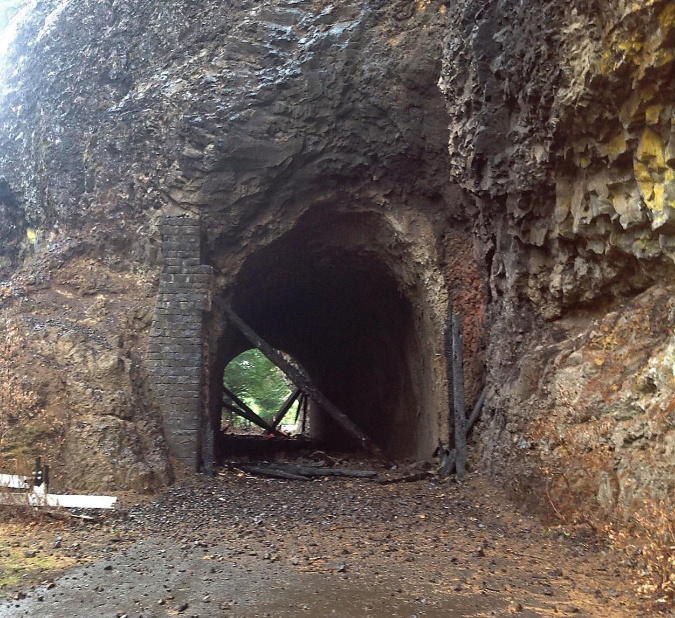
The cobble dam shortly after construction… or perhaps after it was abandoned?

Today, there are still a lot of concrete and steel reminders of the mill town, though they’re often hidden in plain sight, under layers of rust, moss and ferns. For example, this view (below) of the stream below Bridal Veil Falls reveals a “boulder” that is actually a concrete footing and an intake pipe for one of the mill ponds.

warrenfallspostscript25

Mill relics hiding under moss at Bridal Veil Falls

Other large waterfalls on Bridal Veil Creek were impacted by the mill operation, but have recovered dramatically in the decades since the mill finally closed in the 1960s. Here are then-and-now photos of Middle and Upper Bridal Veil Falls:

warrenfallspostscript26

[click here for a larger version]

warrenfallspostscript27

[click here for a larger version]

In more recent years, stolen automobiles have periodically been pushed from the cliffs along historic Palmer Mill Road into Bridal Veil canyon. Some of these dumped vehicles have been pulled from the canyon, but others are too difficult to reach, and are slowly fading into the forest.

While they have undoubtedly released engine fluids into the creek and have plastic parts that will last for decades, nature and Bridal Veil Creek are nonetheless making short work of the rest of these vehicles.

warrenfallspostscript28

Moss and ferns consuming a dumped Hyundai Santa Fe just above Upper Bridal Veil Falls (photo courtesy Jamen Lee)

Unlike Warren Falls, the waterfalls on Bridal Veil Creek were never completely diverted from their natural streambed, yet the overall impact of logging and milling at Bridal Veil had a much larger impact on the larger watershed than anything Warren Creek endured. The fact that Mother Nature has consumed most of what wasn’t salvaged when the flumes were pulled from Bridal Veil canyon in the mid-1900s is an inspiration for the ongoing recovery of Warren Falls.

In time, all traces of our impact on the environment really can heal – provided we allow it to happen. Responsibly cleaning up after ourselves would be a more noble path, of course, but at least nature seems to forgive us in time… so far.

Warren Falls Lives!

warrenfallspostscript29

False alarm! Horsetail does look a lot like Warren Falls, though…

A few weeks ago, the local waterfall hunting community had a brief moment of excitement when a vintage 1918 film seemed to include a rare view of Warren Falls! But after looking more closely at the images, it turned out to be Horsetail Falls in very low flow. So, the hunt for a photograph of Warren Falls before the 1939 diversion project continues.

But the similarity was real, so the following is a rough guess of what we might see – and perhaps, sooner than we think: Warren Falls flowing again, returning its amazing amphitheater to mossy green, as the diversion structure continues to crumble into history.

warrenfallspostscript30

For waterfall devotees, this is Horsetail Falls superimposed on Warren’s dry cliff with the reversed base of Dry Creek Falls providing the foreground.

[click here for a large version]

Of course, we already know what a small amount of flow over Warren Falls looks like during high runoff events, as shown in previous photos in this article. What we don’t know is what the full force of Warren Creek might look like coming over this 120-foot escarpment, and especially what it might do with 77 years of accumulated stream debris piled at the base of the natural falls.

We have a pretty good idea, though, based on recent dam removals around the Pacific Northwest. It turns out that streams are surprisingly quick to redistribute accumulated debris and restore themselves to their natural stream state, as we’ve seen with dam removals on the Hood, Little Sandy and White Salmon rivers.

Today, Warren Creek below falls has been reduced to ditch, radically moved by ODOT from its former channel in the 1950s and devoid of the rocks and woody debris essential to a healthy stream since 1939, thanks to the “trash rack”.

warrenfallspostscript31

Add some rocks and logs to lower Warren Creek and it might look like this someday

[click here for a large version]

When Warren Falls returns, the huge pile of stream debris will begin to move downstream, and the debris-starved lower section of Warren Creek will develop the pools and eddies necessary for salmon and steelhead to spawn, as imagined above.

The good news is that the new HCRH State Trail passes high and wide over Warren Creek, ensuring that the creek can evolve back to a natural state in the future without a redux of the 1930s highway impacts that led to the diversion of Warren Falls.

When will Warren Falls return? Not just now… but perhaps sooner than we think.

Meanwhile, we wait… and watch.

_____________________

(Part two of this article will focus on a review of the newly completed Historic Columbia River Highway State Trail segment from Starvation Creek to Wonder Creek, and passing Warren Falls)

_____________________

 To revisit the complete history of the Restore Warren Falls project, here are earlier WyEast blog articles on the subject:

 An Overdue Warren Falls Update (and a bombshell!)

“Warren Falls Lives… Again?”

Warren Falls Solutions

“Warren Falls, we’re ready for your closeup…”

 Warren Falls Mystery… Solved!

Restoring Warren Creek Falls

_____________________

Warren Falls on Oregon Field Guide

_____________________

Restore Warren Falls on Facebook!


The High Cost of Free Parking (part 2 of 2)

ParkingCostPartTwo01

Cars now overflow the remote Vista Ridge trailhead routinely

This is the second in a two-part series that takes its name from Donald Shoup’s ground-breaking book “The High Cost of Free Parking”, first published in 2005. Shoup documents the many unintended effects of free parking in cities, and many of his proven principles could apply to trailheads in our public lands, as well.

The second part in this series explores some possible solutions for the parking crisis facing the trailheads of the Columbia River Gorge and Mount Hood, and the value of confronting the true costs of free parking to our most treasured public lands.
__________________

No more free parking!

Does anyone really expect free parking at a Timbers or Blazers game, or drop in for dinner without a reservation at one of Portland’s finest restaurants to find a table waiting? Or be exempted from tolls when crossing the Columbia at Hood River and the Bridge of the Gods in Cascade Locks? Of course not, but that doesn’t mean we don’t reserve the right to complain about it! That’s human nature.

ParkingCostPartTwo02

Bumper-to-bumper at Vista Ridge on a Friday

Such is the dilemma for public land managers face as they attempt to impose limits on access to our trails on Mount Hood and in the Gorge. While we can all probably agree that the impacts we now see from overuse require limits on access, we’d probably like someone else to suffer the inconvenience.

The good news is that our most overused trails are relatively few in number. Any seasoned hiker can rattle them off, as many already avoid these trails on popular weekends and seasons: Angels Rest, McCord Creek, Wahclella Falls and Eagle Creek in the Gorge are now infamous for their crowds, while Ramona Falls, Mirror Lake, Salmon River, Elk Meadows and (most recently) Tamanawas Falls on Mount Hood see overflowing weekend crowds.

ParkingCostPartTwo03

Frustrated hikers pushed out of the Wahclella Falls trailhead have resorted to parking on the I-84 off-ramp
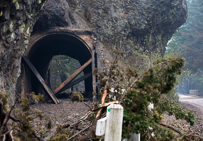
Experienced hikers already know where the lesser-visited trails are and make a point of steering toward these places for a quieter, better outdoor experience. However, as the Portland region continues its rapid growth, even some of these “secret” trails are starting to show some strain: Herman Creek, Starvation Ridge and Gorton Creek in the Gorge and Vista Ridge, Bald Mountain and Cooper Spur have all seen spikes in use over the past decade or so as hikers seek less crowded trails.

We have met the enemy and he is… us!

The first step in adopting a trailhead parking policy to address overcrowding is to recognize the problem: when trailheads routinely overflow, it’s a problem! You can see this on weekends on every one of the overcrowded trails mentioned above. The crowding is now year-round in the Gorge and whenever the ground is snow-free up on Mount Hood.

For some trails, like Mirror Lake and Eagle Creek, the crowds extend beyond the weekends, especially on Fridays and Mondays. But even on these most heavily used trails, weekdays usually mean plenty of parking to spare, with no overflow.

This variation in day-to-day use at the most crowded trailheads is a case study for variable parking fee, with fees set higher on weekends and holidays, and lower (or not at all) on weekdays. As Donald Shoup demonstrates in “The High Cost of Free Parking”, adopting such a strategy can shift weekend and holiday use to less popular trailheads with free parking, or to non-peak days at more popular trailheads.

ParkingCostPartTwo04

The popular Wahclella Falls trailhead still has open spaces on most weekdays

If we adopted a variable pricing policy tomorrow for overused trailheads in the Gorge, we could cut weekend crowding on trails now being harmed by overuse in half, overnight. Sounds easy, right? Well, one complication comes from the public blowback that would almost certainly occur. Remember, we all reserve the right to complain when things aren’t free!

Another complication comes from the fact that several of the most popular trailheads also have heavy tourist use. Places like Horsetail Falls, Wahkeena Falls and Multnomah Falls in “waterfall alley” are good examples where the majority of peak period visitors aren’t hikers, just people touring the Historic Columbia River Highway and walking the paved paths to the most famous roadside views.

Shared tourism and hiking trailheads should be priced, too, as they fit the same definition for overcrowding with parking spilling far beyond established parking areas. Crowding is crowding.

ParkingCostPartTwo05

The impacts of overuse in the Gorge are real and jarring. This boot path cutting a switchback on the Oneonta Creek trail formed in just the past two years.

At Multnomah Falls, a new hazard has emerged from the overflow on weekends, with visitors now parking beyond the narrow historic highway viaducts that flank the falls and lodge. Signs on the viaducts sternly warn against pedestrians walking along them, but whole families are now a common sight in the narrow viaduct vehicle lanes on busy spring and summer weekends at Multnomah Falls.

At Oneonta Gorge, the huge overflow of visitors has created a hazard for hikers attempting to scale the log jam at the mouth of the gorge, and ruined the outdoor experience for those who make it beyond the log pile with a noisy, carnival atmosphere.

ParkingCostPartTwo06

Vandals have almost completely carved up the walls of the restored Oneonta Tunnel since it opened six years ago…

ParkingCostPartTwo07

…a testament to the destructive behavior that allowing large crowds to from on our public lands can foster?

Worse, the overcrowding at Oneonta has led to a shameful degree of vandalism in the recently restored highway tunnel. Would vandals pay to park here? Perhaps, but at least the crowds that lead to that sort of destructive behavior could be prevented with managed parking. Otherwise, this precious gem will likely have to be closed to the public, once again.

At Mount Hood, overcrowding at places like the Salmon River Trail and Ramona Falls has also led to vandalism and car break-ins, in addition to heavy impacts on trails. Managed parking could greatly improve the situation here, while allowing hikers to discover the many lesser-used trails on Mount Hood that could benefit from more boot traffic while providing a far better hiking experience.

ParkingCostPartTwo08

A relatively quiet weekday at the massive (and overflowing on weekends) Ramona Falls trailhead

In many of these examples, a parking pass is already required today, but this has little effect on managing peak use. The key difference is variable pricing for parking that provides an incentive for visitors to avoid peak periods at the busiest trailheads, but gives options of other trails or off-peak days when little or no parking fee is charged. It’s a proven approach whose time as come in our most visited public lands.

…and now transit!

Since proposing a “Boot Loop” transit service on this blog four years ago, we’ve seen significant steps forward in providing transit service to Mount Hood and the Gorge. The Mount Hood Express now provides daily service from the Portland area and on the Washington side of the Gorge, transit service now connects to Stevenson, with a new shuttle to Dog Mountain.

ParkingCostPartTwo09

The new Mount Hood Express bus provides daily service to the mountain.

On the Oregon side of the Gorge, the Oregon Department of Transportation (ODOT) is partway through a pilot project to bring transit service to the most heavily visited spots in the Gorge. ODOT plans to provide service from a park-and-ride location inside the Portland area to the most popular trailheads in the Gorge.

Transit service provides a needed option to driving, especially for those who do not have access to a private vehicle, but also to those who simply want to avoid the hassle of driving (and parking).

Transit is also a good counterpoint to adopting a parking strategy for the Gorge and Mount Hood, as parking fees provide an incentive to use transit during peak periods, which in turn, helps provide the critical mass to keep the service going. This is a tried and proven relationship between parking policy and transit in cities, and overdue as a strategy in our most heavily used recreation sites.

ParkingCostPartTwo10

Park transit station at Niagara Falls State Park, New York

That said, transit is mostly a way to provide another option for visitors. It simply won’t have the capacity to have much impact on overall visitation during peak periods, when parking areas at our most popular trailheads is already overflowing to two or three times the planned capacity for the trail.

How could this work?

Applying Donald Shoup’s parking management practices to recreation areas is less complicated than in an urban setting for the simple fact that there are so few places to manage, most have a single entrance point and they are all in public ownership.

ParkingCostPartTwo11

The Forest Service recently completed a major remodel of the Wahkeena Falls wayside to better manage crowds, but without managing parking, this new landscaping doesn’t stand a chance of surviving the overload.

The public reaction to actually putting a price on parking at our busiest trailheads, even during peak periods, is the driver for why we aren’t already attempting this – not the complexity of actually making it work. After all, cities around the world are already doing it, and against much more complex obstacles.

So, what are the parking management tools that could be borrowed from cities? Here are some that could work in the Gorge and on Mount Hood:

ParkingCostPartTwo12a

ParkingCostPartTwo12e

ParkingCostPartTwo12d

ParkingCostPartTwo12c

ParkingCostPartTwo12b

These systems are all being used in cities today, and some combination of these practices could be applied to parking on our public lands. One challenge for public lands would be on-site enforcement, however, as this is an essential ingredient for urban parking policies.

On this point, I propose that a portion of the trailhead parking revenue could be steered toward dedicated county law enforcement to patrol parking areas. Not only would this provide an essential incentive for visitors to pay their fee, but it would also bring a much-needed security presence for busy trailheads that are increasingly targeted for car break-ins.

ParkingCostPartTwo13

The Starvation Creek wayside does triple duty as a popular trailhead, wayside for tourists and freeway rest stop. This site is a candidate for a combination of short-term timed parking and long-term fee parking.

So, how much revenue does a parking strategy generate? Well, consider that the City of Portland collects some $35 million annually in parking fees from its downtown meters, which in turn contributes to the city’s transportation budget for street maintenance. The city also collects another $7 million annually in fines for parking violators, more than enough to cover its enforcement costs.

While a parking strategy for the Gorge or Mount Hood would be unlikely to bring that much parking revenue, the Portland model does show that fee parking at the most popular trailheads in the Gorge and on Mount Hood could not only cover operational costs, but also bring new revenue for woefully underfunded trail maintenance and construction. That could be a valuable selling point to regular hikers and visitors.

Those pesky agency permits…

One of the institutional obstacles to adopting a coordinated parking strategy for the Gorge, in particular, is the mix of land management agencies involved: the U.S. Forest Service, Oregon Parks and Recreation Department (OPRD) and Washington Department of Natural Resources (DNR) all have some sort of parking permit that applies to some of their respective recreation sites.

ParkingCostPartTwo14

Welcome to Wahclella Falls! Forest Pass or $5 fee required… here.

The Forest Service and OPRD both have a mix of free and fee sites, with the Forest Service requiring a $30 annual Northwest Forest Pass or $5 day-use fee at places like Eagle Creek or Wahclella Falls, but no charge at its busiest locations like Multnomah Falls, Horsetail Falls and Wahkeena Falls, where tourists outnumber hikers. OPRD charges $5 day-use fees at places like Rooster Rock and Benson Lake, but not at busy trailheads like McCord Creek and Latourell Falls.

Meanwhile, on the Washington side of the Columbia, DNR charges a $30 annual fee or $10 daily fee for its Discover Pass to park at places like Beacon Rock, Hamilton Mountain and all other Washington State recreation areas.

All of these are flat-fee permits, so they do nothing to help discourage overcrowding on busy weekends and arguably encourage more use, since an annual fee provides a flat rate for unlimited visits. In fact, the annual passes do just the opposite, encouraging multiple visits for a flat rate. There’s nothing wrong with hikers spending a lot of time in the Gorge, of course, but we all share the burden when it comes to managing the impacts through trailhead parking fees.

ParkingCostPartTwo15

It’s unclear how much revenue is left for trails once administration costs for the Northwest Forest Pass are covered.

Today, trailhead permits are pitched for their ability to generate funds to build and maintain trails, but hikers are rightly skeptical about how much funding actually goes to trails. In the end, it’s not a problem of the trail passes, but rather, by the low fees relative to the trail impacts the most popular trails are experiencing.

For example, a hiker purchasing an annual permit for $30 and spending a dozen days in the Gorge or on Mount Hood each year pays just $2.50 per visit to cover their trail impacts, or less than many hikers will spend on coffee en route to the trailhead.

ParkingCostPartTwo16

Lots of passes and hassle, not much revenue for trails… and no impact on crowding.

There is little chance the states of Oregon and Washington and the U.S. Forest Service will ever join forces and create a unified trail pass, and besides, their pass systems aren’t effective at managing peak use, anyway. Instead, they should cooperate to adopt a pricing strategy for our most overused trails that is an add-on to (or replacement for) the existing pass system at these locations.

The ethics of putting a price on parking?

At this point, you might be thinking (as I generally do) that we should all enjoy free access to our public lands. Of course we should! We pay for tem every April 15, after all. Thus, adding parking fees at our overused trails will most certainly bring howls from avid hikers who spend a lot of time on the trail, and who dutifully purchase their $30 annual trail passes now.

ParkingCostPartTwo17

Would revenue from a parking policy bring more of this to the Gorge and Mount Hood? Almost certainly, if managed properly.

Yet, when overuse starts to bring the “tragedy of the commons” to our most cherished places, it’s time for all of us to step up and find a solution. Putting a price on parking is a proven and effective way to get there. More importantly, pricing is really only needed on our most heavily traveled trails. Most trails will continue to be “free”… of a parking fee, anyway.

Putting a price on parking arguably discriminates against people with limited incomes or who are unable to visit in off-peak periods when little or no fee is required. Land managers will therefore need to consider ways to ensure that everyone can visit our public lands, no matter their ability to pay. But such programs are already in place in several state and National Parks, and could be easily included in a Gorge or Mount Hood parking strategy.

ParkingCostPartTwo18

That’s no road – it’s what the Angels Rest trail has become in recent years, thanks to massive overuse from a complete lack of parking management at the trailhead.

Today, land managers are already beginning to put restrictions on overflow parking in the Gorge and on Mount Hood. It’s a good first step, but not enough to address peak demand on weekends and holidays, and in the end will mostly frustrate visitors who have arrived expecting place to park.

The next step for our public agencies is to start managing parking, itself. It’s long past time to try it in the Gorge and on Mount Hood, for the sake of our trails and most treasured places.

The High Cost of Free Parking (Part 1 of 2)

The notorious Angels Rest Trailhead on a typical winter weekend

The notorious Angels Rest Trailhead on a typical winter weekend

This is a two-part article that takes its name from Donald Shoup’s ground-breaking book “The High Cost of Free Parking”, first published in 2005. Shoup documents the many unintended effects of free parking in cities, and many of the principles could apply to our public lands, as well.

The first part of this series examines the parking crisis facing the trailheads of the Columbia River Gorge and Mount Hood, while the second part will explore some possible solutions — none of them easy to realize until the true costs of free parking are confronted.
__________________

Wall-to-wall hikers are the norm on Dog Mountain in spring (The Oregonian)

Wall-to-wall hikers are the norm on Dog Mountain in spring (The Oregonian)

The Forest Service announced plans this month to redesign the huge parking area at the Dog Mountain trailhead, on the Washington side of the Columbia River Gorge, to address safety issues. The Forest Service plans to stripe the currently unmanaged, free-for-all paved shoulder with designed parking spaces for 75 cars. This is a significant reduction from the roughly 200 cars that pack into the trailhead on busy spring weekends.

To compensate for the reduced parking, the Forest Service is teaming up with Skamania County’s Gorge West End Transit (WET) bus to provide a shuttle from Stevenson to Dog Mountain. The shuttle will run Saturdays and Sundays from April 16 to June 12, the peak season for the hike when the wildflower meadows that make the hike famous are at their peak. The shuttles will run 10 times daily from 10:15 a.m. to 4 p.m., and the one-way fare will be a modest $1.00.

A rare quiet day at the huge Dog Mountain trailhead parking area (The Oregonian)

A rare quiet day at the huge Dog Mountain trailhead parking area (The Oregonian)

The predictable headline in The Oregonian story covering of the announcement screamed “Already hate parking at Dog Mountain? It’s about to get worse”, and the reaction from hikers in social media has pretty much echoed that simplistic, knee-jerk reaction.

But will it really be worse? Seventy-five cars at the redesigned trailhead still translates into roughly 150 people on the trail at any given time — hardly a wilderness experience, and a huge improvement over the 400+ hikers you might currently expect along the 7-mile circuit to the summit from trailhead parking capacity, alone. Some hikers will use the shuttles, but more likely, people will simply go elsewhere — a point I’ll cover in the second part in this series.

Hikers are usually people who love nature, so it’s fair to assume that few hikers would want to see their public lands trampled by unmanaged mobs. And yet, much of the reaction to limiting the number of cars that can park at Dog Mountain has been just the opposite — anger and outrage at any sort of limit on parking or access.

So, why this disconnect? We’ll explore that question in the second part of the series, too, as well as the necessary solutions to overwhelming demand for trails in the Gorge and on Mount Hood in the second part of this series.

First, a closer look at the problems that exist in today’s status quo.

A Typical Weekend…

It’s not news to Gorge regulars that weekends along the Historic Columbia River Highway in “Waterfall Alley” have become outlandish traffic jams, with cars parked anywhere they will fit, and trails literally overrun with thousands of hikers. Local photographer T.J. Thorne filmed a clip in the vicinity of Oneonta Gorge that gives a flavor of what our precious Gorge experience has devolved:

This isn’t fun for anyone. It’s a tragedy of the commons in the making, and tarnishes what could (and should) be a wonderful outdoor experience for people looking for some relief from their daily, urban routines.

How did it get this bad? Rapid growth in the Portland metropolitan is part of the answer: while the Gorge trail system is only slightly larger than it was in 1940, the Portland-Vancouver region has exploded from just over 500,000 residents then to more than 2 million today. Compounding the growth is Portland’s emerging lifestyle economy, whereby new industries locating here are increasingly do so because their workers want easy access to our amazing outdoors.

So, one answer is more trails — something I promote regularly in this blog, and something that can be done responsibly and in a way that greatly expands opportunities for people to have a positive outdoor experience. But getting there will take major reforms in how the Forest Service and Columbia Gorge Commission, in particular, think about recreation (both are surprisingly hostile to new trails) as well as restoring funds to gutted federal trail budgets.

Forest Service trail legend Bruce Dungey and his crews are struggling to stem the damage from overuse of Gorge trails

Forest Service trail legend Bruce Dungey and his crews are struggling to stem the damage from overuse of Gorge trails

The federal budget problem is real: consider that Forest Service crews in the Gorge are now about one-fourth the size they were as recently as 1990, and the scope of the trail funding crisis is clear enough. Without volunteers from organizations like Trailkeepers of Oregon (TKO), Washington Trails Association, Friends of the Gorge and the Pacific Crest Trail Association our trails would literally be falling apart and impassable from fallen trees and slides. Mount Hood faces a similar backlog and dependence on volunteers to simply keep the trails open.

Not Playing Well Together?

A good share of the overcrowding and also comes from a failure of public land agencies to work together on common solutions. This is especially true in the Gorge, but also on Mount Hood, where the key players are the U.S. Forest Service, Oregon Department of Transportation (ODOT), Oregon Parks and Recreation Department (OPRD) and the Washington Department of Natural Resources (DNR) .

Consider the trailhead parking policy along on the Oregon side of the Gorge: parking at Latourell Falls, Shepperd’s Dell, Wahkeena Falls, Multnomah Falls, Oneonta Gorge, Horsetail Falls, Elowah Falls, Starvation Creek and Mitchell Point is free, no permit required.

The small, free parking area at Elowah Falls is overflowing by dozens of cars, even on rainy winter days

The small, free parking area at Elowah Falls is overflowing by dozens of cars, even on rainy winter days

Meanwhile, parking at Wahclella Falls, Bridge of the Gods, Eagle Creek, Wyeth and Herman Creek requires a Northwest Forest Pass ($30 annual pass or $5 day pass). This can’t be explained simply by state vs. federal management differences, as the Forest Service operates several of the trailheads where free parking is provided, and the state operates both free and fee-based sites, with State Parks at Rooster Rock, Benson Lake and Viento requiring a $5.00 day-use free.

On the Washington side, trailheads provided by the DNR at places like Beacon Rock and Hamilton Mountain require a special DNR permit ($30 annual pass or $10 day pass), while Forest Service trailheads like Dog Mountain require a Northwest Forest Pass.

Confused yet?

It gets worse: on Mount Hood, the Forest Service is well down the troubling path of commercializing both campgrounds and trailheads to “concessionaires”, who in turn, get to set their own fees for day use, which includes parking at trailheads. Several of these trailheads are also posted with a Northwest Forest Pass requirement, so it’s unclear if paying one is the same as paying the other, or even whether being ticketed by a “concessionaire” has any legal standing.

The price to park at Mount Hood’s snow park lots is the same any day of the week, overloading parking areas and the Loop Highway

The price to park at Mount Hood’s snow park lots is the same any day of the week, overloading parking areas and the Loop Highway

Meanwhile, show up at the same trailhead on Mount Hood between November and April, and it might be a Snow Park site, which has its own permit, operated by the Oregon Department of Transportation ($25 annual or $4 day). Just to make things interesting, “agents” who sell Snow Park permits can charge an additional service fee — something you learn when you stop by one of the grocery stores or service stations that offer these permits.

This amazing cocktail of free and permit parking is a major point of annoyance to hikers, both for the inherent confusion and the actual cost of buying multiple passes to use trails in the same area. That’s bad public relations for the land agencies and bad news for the public. But the tangle of policies and permits is especially bad for tourism, with visitors unfamiliar with the area forced to decipher these overlapping regulations.

Dumb Fees vs. Smart Fees

As frustrating as this crazy quilt of fees (or lack of fees) is for the public, the effect is worse when you consider that most of the permitting program do little to actually manage crowding and protect trails from overuse. Why? Because they are all flat fees that don’t recognize that demand for recreation fluctuates wildly by season and day of week on both Mount Hood and in the Gorge.

The Forest Service will soon build this new trailhead for popular Mirror Lake - a chance to try a different parking approach?

The Forest Service will soon build this new trailhead for popular Mirror Lake – a chance to try a different parking approach?

In The High Cost of Free Parking, Donald Shoup describes how building enough free parking to meet narrow peaks in demand results in oversized, mostly empty parking lots while promoting even worse crowding during peak periods. And yet, there are fairly straightforward tools for managing parking to avoid these effects on our cities.

Much of what Shoup proposes for cities could be adapted for trails and other activities on our public lands, and that will be the focus of the second part of this series: a set of specific actions that could not only make the outdoor experience for everyone better, but also protect the scenery and trails that we go to the outdoors to experience, and ensure that is will still be here for future generations to enjoy.

To be continued…

A New Vision for Mirror Lake (Part 1 of 3)

Summer evening view of Mount Hood from Mirror Lake

Summer evening view of Mount Hood from Mirror Lake

Big changes are coming to the Mirror Lake Trail on Mount Hood, perhaps the single most visited trail on the mountain. This is the first of three articles on the future of Mirror Lake, and the need for a broader vision to guide recreation in the area.
____________

As part of the unfortunate widening of the Mount Hood Highway currently underway west of Government Camp (see this article for more on the subject), the Oregon Department of Transportation (ODOT) has persuaded the U.S. Forest Service to close the existing, historic trailhead for the Mirror Lake Trail.

ODOT claims safety is the chief concern, a point I will visit later in this series. For now, though, it looks like our highway department will close yet another roadside trailhead in a campaign to gradually morph the Mount Hood Highway into full-fledged freeway.

Going back to the beginning…

Just as Mount Hood generally bears the development pressures of being an hour from Portland, and along transportation corridor that dates to the 1840s, Mirror Lake has long carried the burden of being the closest mountain lake to Portland, and the first easily accessible trailhead along the loop highway.

Because of its proximity, the lake shows up on the earliest maps of the Government Camp area, when the Mount Hood Loop Highway had a very rough, early alignment and was not yet a loop. The original Skyline Trail map (below) from the early 1900s shows Mirror Lake just west of the new trail, and a version of the early loop road before the Laurel Hill switchbacks were built.

1920s-era map of Mount Hood and the Government Camp area

1920s-era map of Mount Hood and the Government Camp area

By the early 1920s, the effort to complete the loop highway was in full swing, including the graceful switchbacks that scaled Laurel Hill (below), the spot where Oregon Trail immigrants had to lower their wagons with ropes because of the steepness of the terrain. Surprisingly, a formal trail to Mirror Lake had not yet been constructed by this time.

1920s map of the first paved alignment of the Mount Hood Loop Highway at Government Camp

1920s map of the first paved alignment of the Mount Hood Loop Highway at Government Camp

Other maps from the early 1900s (below) tell another story about Mirror Lake: it was within the northern extent of the Sherar Burn, a massive fire that had destroyed forests from the Salmon River to Camp Creek. As recently as the 1980s, bleached snags from the fire were standing throughout the Mirror Lake area.

1920s map showing the Sherar Burn extent in the Mirror Lake area

1920s map showing the Sherar Burn extent in the Mirror Lake area

The Sherar Burn of the mid-1800s created vast tracts of huckleberries across the area, and during the early days of the highway, huckleberry pickers were a common sight, selling coffee cans of fresh berries to mountain visitors (below).

Huckleberry pickers in the 1930s at the Little Zigzag River bridge, below Laurel Hill

Huckleberry pickers in the 1930s at the Little Zigzag River bridge, below Laurel Hill

Mirror Lake, itself, looked quite different in the 1920s, too. Today’s tree-rimmed lake was mostly surrounded by burned snags and fields of beargrass and huckleberry in the 1920s (below).

Mirror Lake in the late 1920s

Mirror Lake in the late 1920s

Sometime in the late 1920s or early 1930s, a new trail was constructed from the new highway to Mirror Lake. The trail began at a sharp turn on the old highway, traversing above the north shoulder of Yocum Falls on Camp Creek, crossing to the south side of the creek at the spot where the modern trailhead is located today (see maps below).

This lower section (from the bend in the old highway to the modern trailhead) of the original Mirror Lake trail was destroyed just 25 years later, when the modern highway grade cut through the area. This portion of the old highway still exists in this area, accessible from the Laurel Hill historic landmark pullout (currently closed because of the highway widening).

1930s map of the original Mirror Lake Trail

1930s map of the original Mirror Lake Trail

1930s map of the Mirror Lake Trail and surrounding area

1930s map of the Mirror Lake Trail and surrounding area

When the original Mirror Lake Trail was built, the trailhead was located just a few yards beyond an impressive roadside viewpoint of Yocum Falls on Camp Creek (below). Today, the forest has recovered so completely in this part of the Sherar Burn that this viewpoint is completely overgrown. It is still possible to visit Yocum Falls from the old highway grade, though, by following rough use trails.

Yocum Falls as it once appeared from the original Mount Hood Loop Highway

Yocum Falls as it once appeared from the original Mount Hood Loop Highway

The lower section of the original trail seems to have followed the rambling extent of Yocum Falls quite closely before the trail was destroyed by the modern highway. While the current trailhead gives a brief glimpse of the top of the falls, the old route seems to have provided a nice view of the falls since lost (more on this topic in the third part in this series).

Today, the modern Mirror Lake trailhead continues to provide a popular drop-in hike for families and casual hikers, but the convenience comes at a price. The shoulder parking area is large enough to allow up to 100 cars, and on busy weekends, still more hikers park along the highway all the way to Government Camp, walking the highway shoulder to reach the trailhead.

The Mirror Lake Trail was never designed to handle this much traffic, nor is the small lake able to handle so many visitors. These concerns are part of the Forest Service thinking in why a new trailhead should be constructed.

Camp Creek suffers from its close, unprotected proximity to Highway 26 and the Mirror Lake Trail parking.

Camp Creek suffers from its close, unprotected proximity to Highway 26 and the Mirror Lake Trail parking.

Meanwhile, the 1950s-era trailhead pullout in use today was built at a time when little thought was given to environmental impacts. As a result, highway fill was pushed to the edge of Camp Creek, exposing an important salmon and steelhead stream to heavy loads of silt and pollution from parked vehicles. A visit to Yocum Falls, just downstream, reveals a troubling amount of road debris and the sharp odor of pollution in an otherwise healthy stream corridor.

While these growing impacts on Mirror Lake and Camp Creek aren’t the reason ODOT gives for closing the current Mirror Lake Trailhead, they are compelling arguments to consider.
____________

The next part of this 3-part series will take a closer look at ODOT’s arguments for closing the existing trailhead and the Forest Service proposal for a new trailhead located east of the existing access.

Cool news in the summer heat!

Hood River Confluence at Punchbowl Park (photo by Peter Marbach)

Hood River Confluence at Punchbowl Park (photo by Peter Marbach)

In my last post, I alluded to some pending good news on the WyEast beat, and in this article I’ll share a trio of pleasantly cool developments for our otherwise scorching summer:

Punchbowl Park Project

Starting off with the big news, the folks behind the Punchbowl Park project learned in late June that they had been awarded a State of Oregon grant of $470,000. These funds will make it possible for Hood River County to acquire the 103-acre Punchbowl Park site in partnership with the Western Rivers Conservancy.

Kayakers at the Hood River Confluence at Punchbowl Park (photo by Peter Marbach)

Kayakers at the Hood River Confluence at Punchbowl Park (photo by Peter Marbach)

This is a huge step forward for this citizen-led movement, a major grass-roots effort guided by Heather Staten of the Hood River Valley Residents Committee (HRVRC). Now that the future of the site is secure, Heather and her organization will be working with the county to begin building a recreational trail network through the new park for the public to enjoy.

Map of proposed trail network at Punchbowl Park

Map of proposed trail network at Punchbowl Park

[click here for a larger map]

Much more work lies ahead for Punchbowl Park, and I’ll continue to post updates here on new developments and opportunities to get involved in the trail building over the coming years. Kudos to Heather and those who pitched in for the tireless work that made this happen. Bringing this area into public ownership is a once-in-a-lifetime opportunity, and one that will pay off for many generations to come!

You can already explore Punchbowl Park in its undeveloped state now by following the maze of user trails that already exist there. You will likely notice signs of recent logging — part of an operation to remove diseased trees from the forest in hopes of limiting their spread. The long-term plan for the new park is to let nature take over, and allow the forest to recover to a more natural state after a century of timber harvesting.

Restore Warren Falls

Warren Creek canyon (and falls) from across the Columbia

Warren Creek canyon (and falls) from across the Columbia

For a second bit of cool news, we move west to Warren Falls. In mid-July, I sent a “Hail Mary” plea to local legislators in the Hood River area asking for their (divine?) intervention to somehow prod the Oregon Department of Transportation (ODOT) into decommissioning the Warren Creek diversion tunnel and restoring Warren Falls. I’ve posted several articles on this proposal (as well as this Oregon Field Guide story) in hopes of doing this needed restoration work when the state will have heavy equipment in the area as part of the next phase of the Historic Columbia River Highway (HCRH) State Trail, which will soon cross Warren Creek.

My plea for help was answered promptly and with enthusiasm by State Senator Chuck Thomsen of Hood River. Senator Thomsen agreed to me at the Starvation Creek Wayside early one morning last week for an inspection of the Warren Falls site and a briefing on my proposal to restore the falls. After our tour, he offered to write a letter to both ODOT and the Governor’s office asking them to put Warren Falls on their to-do list. Boom!

The author with Senator Chuck Thomsen at Warren Creek

The author with Senator Chuck Thomsen at Warren Creek

More to come, but simply contacting a legislator has already triggered a call from an ODOT surrogate, essentially asking me to cease and desist in my efforts. I assured them that I had no desire to delay the larger state trail project, but still believe the agency should (and can) do right by undoing their illegal diversion of Warren Creek — and restoring Warren Falls in the process.

I’m convinced that if ODOT channeled the spirit of Samuel Lancaster when he designed the historic highway a century ago, they would easily discover both the will and funding needed to make this happen. And if they do, Sam Lancaster will surely approve — wherever he might be!

If you’re interested in more detail, here’s a (large) PDF of my Hail Mary! letter to Senator Thomsen.

Palmer Glacier gets a Reprieve

Like tractors on a corn field, snowcats plow (and salt) the Palmer Glacier for summer skiers

Like tractors on a corn field, snowcats plow (and salt) the Palmer Glacier for summer skiers

Five years ago, I posted this article challenging the Timberline Ski Resort on their practice of “conditioning” the Palmer Glacier with the equivalent of 500 tons (picture 500 pickup loads) of salt on the glacier each summer.

To defend the practice, the resort points to water quality testing downstream showing only “reasonably elevated levels” of salt in the tributaries that feed into the Salmon River, as if there is something reasonable about purposely pouring salt into one of our premier rivers. The Salmon River is not only treasured for its epic waterfalls and rugged gorge, it’s also a wild and scenic river and among the few salmon and steelhead streams in the Oregon Cascades with no downstream dams to block fish migration. There’s a lot at stake, here.

The source of the Salmon River at the terminus of the Palmer Glacier

The source of the Salmon River at the terminus of the Palmer Glacier

The Forest Service, meanwhile, is also of the “well, let’s see what happens” mindset, and officially permits the Timberline resort to keep dumping tons of salt on Mount Hood most fragile glacier. And yes, it’s still a glacier in name, though you may have noticed that the official media term coming from both the Timberline Resort and the Forest Service is the dismissive “Palmer Snowfield”. I can only guess the thinking behind this, but it’s hard to imagine it not being an attempt to downplay the impacts of salting the glacier.

Yup, still the Palmer Glacier…

Yup, still the Palmer Glacier…

Meanwhile, the Palmer Glacier continues to shrink, along with the rest of our Cascade glaciers in this period of global climate change. The Timberline Resort actually posted a letter to President Obama on their website proclaiming their “strong support for policies to address climate change”, all the while purposely accelerating the melting of their bread-and-butter glacier. Given the contradiction, it’s fairly easy to differentiate the empty rhetoric from the short-term profit motives.

How salty is this runoff from the Palmer Glacier? Enough for the Timberline Resort to be on the defensive, apparently.

How salty is this runoff from the Palmer Glacier? Enough for the Timberline Resort to be on the defensive, apparently.

Ski areas don’t just bring invisible pollution to the Salmon River -- here, a broken boundary pole and ski trash litter the Salmon River headwaters.

Ski areas don’t just bring invisible pollution to the Salmon River — here, a broken boundary pole and ski trash litter the Salmon River headwaters.

The greatest tragedy is that we own the land and the glacier, not the resort. They’re simply leasing the space. So, after the glacier is gone, we’ll own the polluted alpine slopes left behind by the salting practice — as the effects of salt pollution are long-term in nature, and of little concern for ski resort balance sheets or Forest Service concession permits.

So, where’s the cool news in this story? Just that the Timberline resort is closing down the Palmer ski season this weekend — a full month before their advertised “June through Labor Day” summer season concludes.

The Palmer Glacier won't miss those snowcats, skiers or tons of salt this August!

The Palmer Glacier won’t miss those snowcats, skiers or tons of salt this August!

This bit of good news for the Palmer Glacier and Salmon River is real: it translates into hundreds of tons of salt that won’t be spread on the glacier over the month of August this year, and that in turn equals less salt in the river and fragile alpine slopes in a dangerously low water year. It might even mean less melting of the glacier than might happen otherwise.

So, it’s cool news of a sort… and might just help keep the Palmer Glacier around just a bit longer.

An Overdue Warren Falls Update (…and a bombshell!)

Warren Falls lives! Well, occasionally… during the wettest winter storms

Warren Falls lives! Well, occasionally… during the wettest winter storms

Time is running out on the Restore Warren Falls! project. This summer the next phase of the Historic Columbia River Highway (HCRH) State Trail project will begin construction of a segment that will pass right in front of the falls.

The new trail construction in the area is not simply an ideal opportunity to finally undo what the Oregon Department of Transportation (ODOT) did to this magnificent waterfall 76 years ago — it’s probably the only opportunity in our lifetimes.

In that spirit, I thought an update on the project and Warren Falls was in order — plus share a bit of a bombshell that was sent to me recently!

Checking in on Warren Falls

First, a quick visit to Warren Creek: in mid-April I made a couple visits to Warren Falls as part of my twice-annual Friends of the Gorge hikes. As has become the norm in recent years, the natural falls clearly flowed again this winter during heavy runoff that overwhelmed the diversion weir at the top of the falls.

The flood path from the briefly reborn falls cleared leaf debris as shown by the arrows in this photo…

The flood path from the briefly reborn falls cleared leaf debris as shown by the arrows in this photo…

…and in this photo, where the overflow stream continued down the ancient creekbed

…and in this photo, where the overflow stream continued down the ancient creekbed

These regular overflows make more sense when you look at the condition of the weir — the following photos from the top of the falls show just how clogged the giant “trash rack” has become, and also how badly the upper lip of the rack has been exposed as the concrete diversion dam continues to erode:

Over its 76-year life the enormous weir has become twisted and clogged with debris, causing more overflows each year

Over its 76-year life the enormous weir has become twisted and clogged with debris, causing more overflows each year

The steel beams that make up the weir are also coming loose from their foundation as the concrete diversion dam deteriorates with time

The steel beams that make up the weir are also coming loose from their foundation as the concrete diversion dam deteriorates with time

The Friends of the Gorge hikers always marvel at the strange, unsettling scene of a dry waterfall. Like most who visit Warren Falls, many are also saddened by the idea that the ODOT could have been so cavalier in altering such a beautiful scene at Warren Creek so grotesquely.

While the original decision to divert the falls can arguably be blamed on the thinking of the era (late 1930s), I would submit that allowing this tragic mistake to continue to exist is equally cavalier and dismissive of the natural landscape at Warren Creek. Thus, my campaign to attach the burden of undoing the mess at Warren Falls to ODOT — and in particular, their looming state trail construction project that will soon begin in the area.

Gorge Friends hike at Warren Creek in April

Gorge Friends hike at Warren Creek in April

While researching Warren Falls over the winter, I finally found a definitive story on the official naming of the creek. The name “Warren” comes from Warren “Barney” Cooper, and early forest ranger in the Mount Hood area (and part of the Cooper family described in this previous article).

This Oregonian article documents (in the last paragraph) when Warren Cooper’s name finally became the official name of the creek in 1948, though it had been in unofficial use for years:

WarrenFallsUpdate07

So, we now learn that Warren Lake and creek were once called “Warm Lake” and “Warm Creek”. Warren Lake is situated on a high, rocky shoulder of Mount Defiance, and shallow enough to be “warm” in late summer, so that could be the simplest explanation for this early name.

The name “Warren” appears on maps and early documents from well before this 1948 decision, so the timing of the article is interesting, especially so long after Warren Cooper’s death in 1920. Was the naming in 1948 simply cartographic housekeeping or an overdue recognition of a pioneering forest ranger by those who followed him?

As always, every answer brings a few new questions!

Friends of Warren Falls… are everywhere!

Since the Oregon Field Guide story on the Restore Warren Falls! project first aired the fall of 2012 (watch the documentary here), several anonymous “friends” of Warren Falls have quietly contacted me with offers to help.

OFG's Vince Patton and Michael Bendixen looking for the illusive Warren Falls in the winter of 2012

OFG’s Vince Patton and Michael Bendixen looking for the illusive Warren Falls in the winter of 2012

Most surprising among the proposals were offers to simply “monkey-wrench” the weir at the top of the falls to speed up its demise! While I’m sympathetic to both the frustration and impatience behind the monkey-wrenchers out there, I’m also concerned that tinkering with the weir might actually be illegal (though it’s hard to see how a decaying structure that no public agency will claim responsibility for could somehow also become the basis for legal action..?)

More importantly, I’m concerned that formally removing the weir and associated debris will become increasingly difficult if the structure is further compromised. I’ve therefore thanked the monkey-wrenchers for their passion, but encouraged them to be patient and allow the slow wheels of government to turn a bit further..!

…and the bombshell…

Another piece of information that trickled in from an anonymous attorney and friend of Warren Falls is found in plain sight: in the Oregon Revised Statutes. Specifically, ORS 538.200, which exists solely to prohibit the diversion of “streams forming waterfalls near the Columbia River Highway” for “any purpose whatsoever”.

While quite clear in its intent, this might seem like a very general reference. But the statute (which was signed into law in the early 1900s, before the Warren Falls diversion) goes on to list each of the streams and waterfalls that fall under this protection — including Warren Creek, in ORS 538.200(26)!

An unusual view of Warren Creek topping its weir and overflowing into its natural falls (visible behind the trees)

An unusual view of Warren Creek topping its weir and overflowing into its natural falls (visible behind the trees)

What does this new information mean? For starters, it means that ODOT — at the time, called the Oregon Highway Division — broke the law in 1939 when it blasted a diversion tunnel and erected a dam and weir to pipe Warren Creek away from its natural falls and streambed. That is quite clear.

What is unknown is whether the ODOT decision to defy the law in the late 1930s was brazen in its intent. As hard as that possibility is to believe, it is also very hard to believe the agency wouldn’t have known about the law, given that it had been enacted just a few years prior the Warren Falls diversion project being concocted in the early 1930s — and was specifically aimed at the state’s premier highway of the era.

What does it mean today? In my view, it means that ODOT now has BOTH a legal and ethical responsibility to undo what it has done to Warren Falls. That couldn’t be more clear.

The End Game?

For the past four years I’ve been beating the drum to connect the restoration of Warren Falls to the massive, multi-million dollar Historic Columbia River Highway state trail project, without much success. So far I have:

• been turned away by both Oregon State Parks and the U.S. Forest Service, both claiming the falls lies on the other agency’s property (though it quite clearly falls on Oregon State Parks land)

• unsuccessfully pitched the cause to three of the premier conservation groups active in the Gorge, including on-site tours, but did not persuade any of the groups to adopt the cause.

• unsuccessfully made the case twice before the Historic Columbia River Highway steering committee, with some sympathetic interest from the committee, but a deep reluctance to seriously consider the idea. It was added as an item “for consideration” — but later dropped due to cost concerns.

• successfully pitched the idea to the producers of Oregon Field Guide story, and while ODOT staff involved in that effort were sympathetic to the state of Warren Falls, the publicity created by the story did not change their recommendations to their steering committee for any further consideration of restoring the falls.

• posted a string of articles on this blog and started a Facebook group two years ago to continue to rally the cause, but these efforts haven’t made a noticeable dent at ODOT, either.

We are now in the end game, and I don’t think the Warren Falls will ever be restored if the work doesn’t happen when ODOT has heavy equipment in the area later this year. After that, it will most likely be up to Mother Nature, and that’s would be such a sad commentary to future generations when they judge the state of the world we choose to leave them.

From the beginning, I have argued that restoring the falls isn’t about money, but rather, about responsibility. ODOT created the mess that now exists at Warren Creek, and for a whole variety of safety, ethical, environmental — and now, legal — reasons that I’ve argued over the years, it’s time for the agency to own up to their responsibility.

No fooling, ODOT has $2 million annually in a “contingency” fund for exactly the kind of work that restoring Warren Falls would entail — and just allocated another half-million dollars to cover additional costs for the state trail project in the Warren Creek area.

It turns out the money has always been there, too. On April 1, ODOT quietly pulled nearly a half-million dollars in “contingency” funds into this latest phase of the state trail as a consent item before the Oregon Transportation Commission. The new money is for a previously unplanned bridge over nearby Gorton Creek, a worthy addition at the east end of the current phase of construction. Warren Falls could be restored for a fraction of that amount – if only the will and sense of agency responsibility at ODOT existed.

My next efforts will focus beyond ODOT, given my fruitless efforts to work with the agency. At the top of my list of arguments is the newly discovered fact that the agency violated state law when they built the project in 1939 — underscoring the notion that ODOT has both ethical and legal obligations to own up to restoring the falls. The agency clearly has funding available for worthy efforts like this one if the desire exists. I will be making that argument, as well.

There's still time to realize this vision… but not much.

There’s still time to realize this vision… but not much.

I’ll post a follow-ups to article with more details soon, and especially how you might be able to help get the restoration of Warren Falls unstuck from our state bureaucracy. Most of all, a big thanks to all who have offered to help — and as always, thank you reading this blog and caring about Mount Hood and the Gorge!