In the Realm of St. Peter

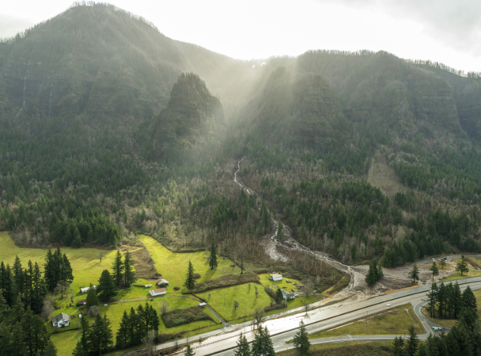
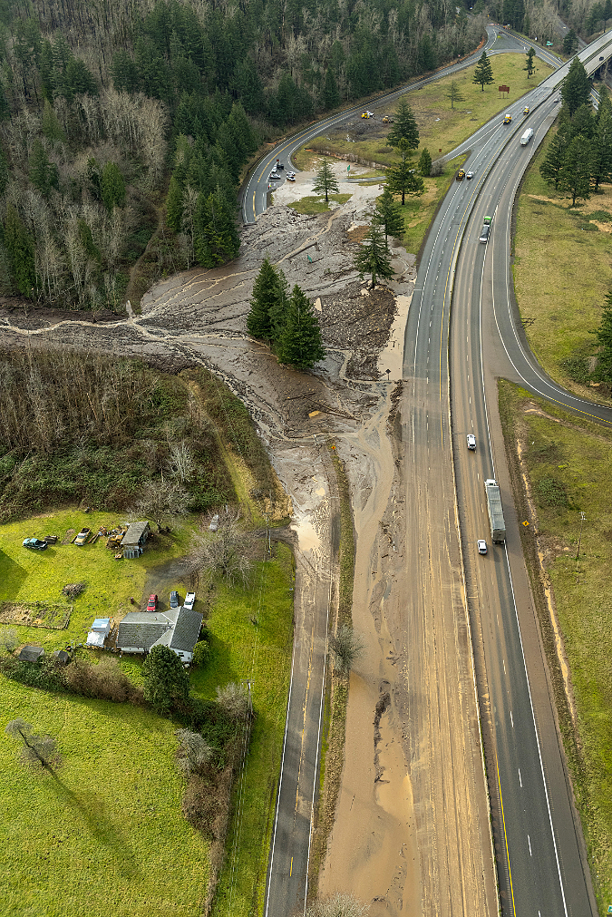
St. Peters Dome rising above the January 13 Bucher Creek debris flow that swept across I-84, killing one person (ODOT)

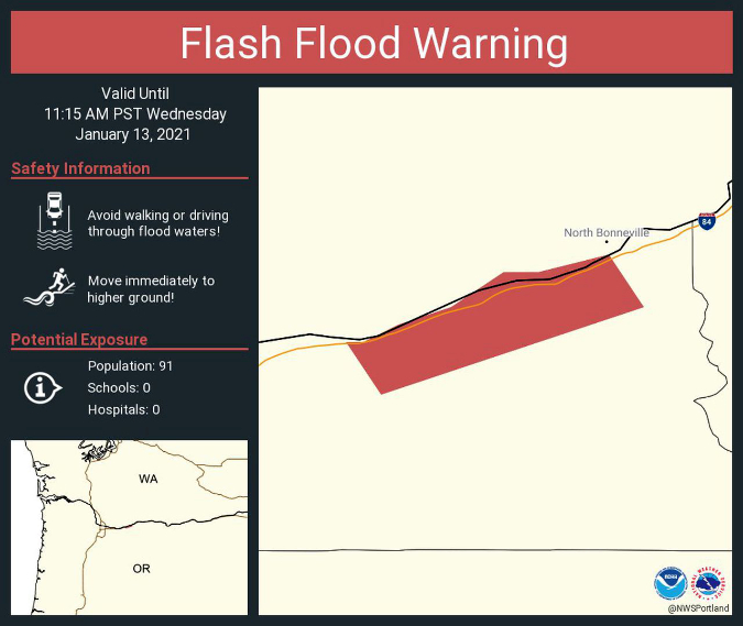
It seems a world away as we enter yet another summer drought, with record-breaking heat waves and an early wildfire season in WyEast country. Yet, just a few months ago, on January 13th, the tragic story of a Warrendale Resident being swept away in her car by a winter debris flow in the Columbia Gorge filled our local news. The event closed a 10-mile section of I-84 from Ainsworth State Park to Tanner Creek and the area was evacuated after the National Weather Service issued a flash flood warning. 

Some of the local media coverage also connected the dots, reporting on the long history of dangerous debris flows in this part of the Gorge. This was not a freak tragedy, but rather, a completely predictable event. The well-known hazard zone stretches from Ainsworth State Park on the west to Yeon State Park, five miles to the east, encompassing the hamlets of Dodson and Warrendale in its path. While the steep walls throughout the Gorge are infamous for producing rockfall and landslides, this stretch is notoriously active. Why?

Slip-sliding away…

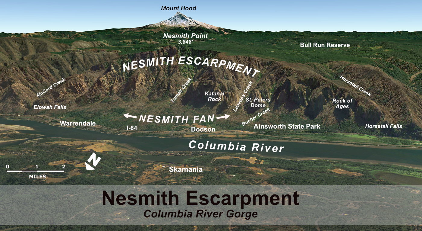
Geoscientists don’t have a particular name for this geologically active area, but the unifying feature is a near-vertical wall that I will call the Nesmith Escarpment for the purpose of this article. The name that comes from Nesmith Point, which has the distinction of being the tallest feature on the Gorge rim, rising nearly 4,000 feet from the banks of Columbia River. The Nesmith Escarpment was largely created by the ancient, catastrophic Missoula Floods that shaped much of what we know as the Columbia River Gorge during the last ice, more than 13,000 years ago. These floods repeatedly scoured the Gorge with torrents hundreds of feet deep, often enough to overtop today’s Crown Point and Rowena Plateau.

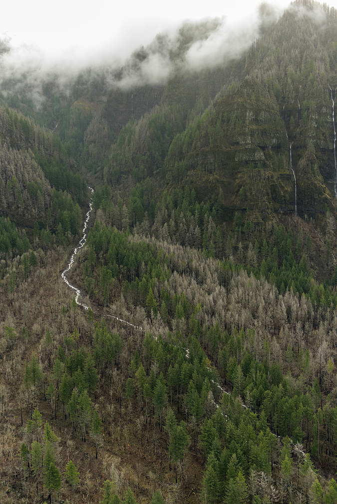
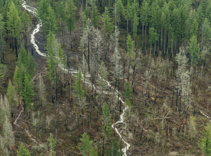
Tumalt Creek is the largest of the volatile streams that flow from the towering, over-steepened Gorge walls of the Nesmith Escarpment(ODOT)

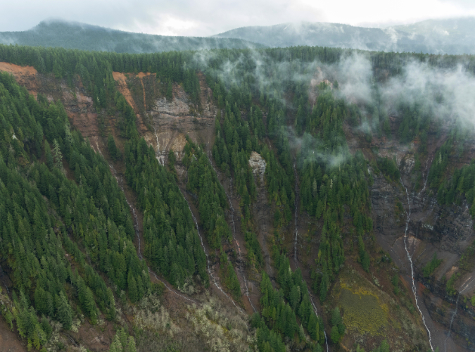
As the massive Missoula Floods cut into the slopes below Nesmith Point, the over-steepened terrain began to collapse into the river. It’s a process that continues to this day, gradually expanding the escarpment and leaving behind sheer basalt towers of resistant bedrock along the lower slopes. Of these, St. Peters Dome is the most prominent, along with Rock of Ages and Katanai Rock (the informal name for the impressive monolith that rises just east of St. Peters Dome).

The headwaters of Tumalt Creek flow from the highest walls of the Nesmith Escarpment, where the red, volcanic layers of the Nesmith Volcano that rests on the Gorge rim have been exposed by erosion  (ODOT)

Adding to the geologic uniqueness of the Nesmith Escarpment is Nesmith Point, itself. Located at the top of the escarpment, the familiar layer-cake stack of basalt flows that make up so much of the Gorge geology gives way at Nesmith Point to bright red and yellow layers of clay and cinders that reveal the uppermost part of the escarpment to be the remains of a volcano. The northern half of the volcano has been torn away over the millennia by the growing escarpment, leaving a visible cross-section of the volcanic dome. The surviving, southern half of the Nesmith volcano is gently sloping, like other dome volcanoes that line the Oregon side of the Gorge (the familiar peaks of Larch Mountain and Mount Defiance among them).

[Click here for a large version of the schematic]

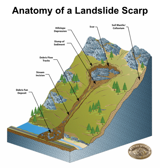
The result of all this erosion is a 3-mile-long amphitheater of collapsing layers of volcanic debris and basalt walls resting uncomfortably and over-steepened upon ancient sediments at the base of the cliffs that make for a slippery, unstable foundation. Rain, winter freezes and gravity will therefore continue to chip away at the escarpment for millennia.

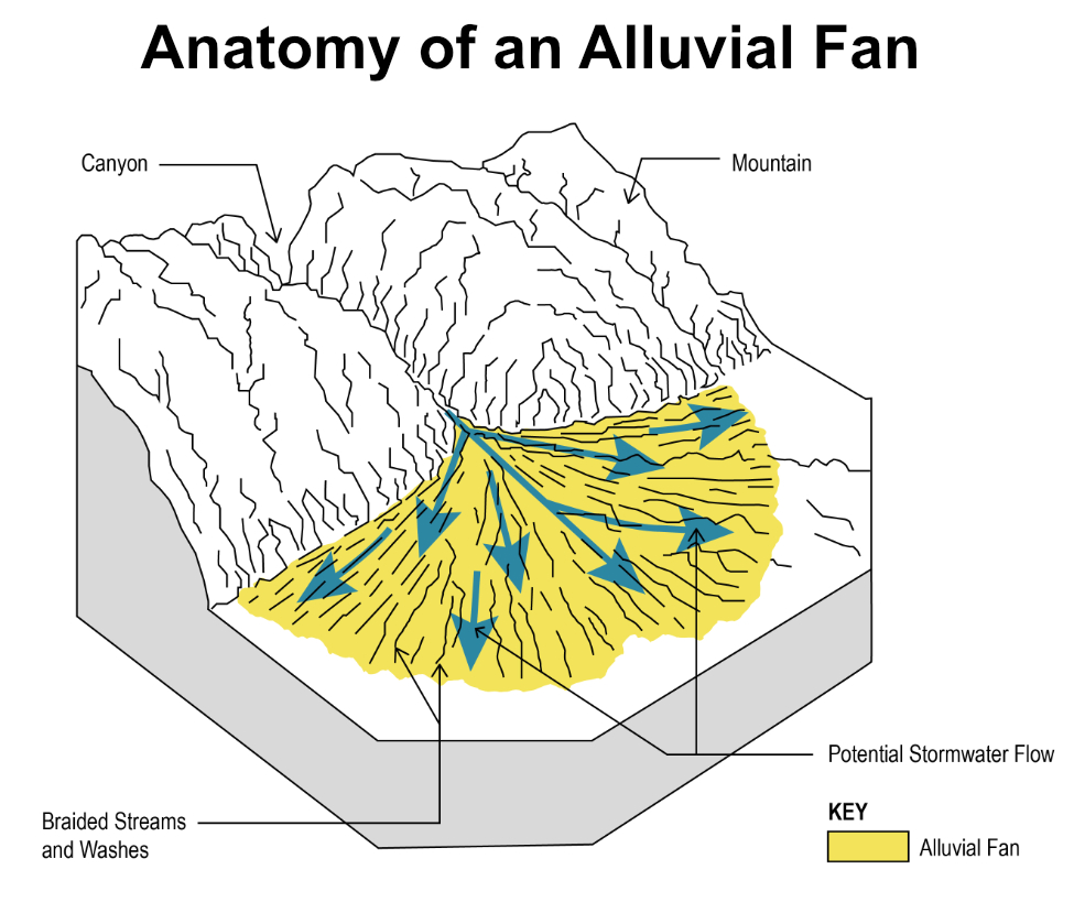
Over the many centuries since the Missoula Floods, this relentless erosion has built a huge apron of what geoscientists call an “alluvial fan” at the base of the Nesmith Escarpment. This name describes the flood debris that accumulates where canyon streams prone to flash-flooding suddenly reach a valley floor, slowing and depositing debris over time. The resulting layers typically form a broad, gently sloped wedge shaped like a fan. For the purpose of this article, the fan at the base of the Nesmith Escarpment will be referred to as the Nesmith Fan

(Source: State of Wyoming)

(Source: City of Scottsdale)

One of the defining features of an alluvial fan is the erratic, constantly shifting course of the streams that create them. Because of their shallow slope and the accumulation of debris, these streams continually change course as they spread their loads of rock and gravel on the fan.

If the Nesmith Escarpment and debris fan were located in a desert environment, these defining features would be exposed and easy to see. But in the forested western Gorge, the dense rainforest vegetation quickly covers debris flows with new growth, often within five or ten years, making it hard to recognize how active the geology really is. It’s therefore easy to understand why settlements like Dodson and Warrendale were built upon on the Nesmith Fan, where the fertile ground and gentle terrain were friendly to farming and home sites. The spectacular cliffs of the Nesmith Escarpment simply provided a beautiful backdrop for these communities. Yet, it’s also an increasingly hazardous place for anyone to live.

The image below shows the Nesmith Escarpment and debris fan in a way that wasn’t possible until LIDAR technology was developed. LIDAR allows highly detailed images of topography even in areas like the Gorge, where dense forests cover the terrain. The LIDAR view shows the steep walls of the escarpment in stark relief, including the hundreds of steep ravines that have formed along the escarpment.

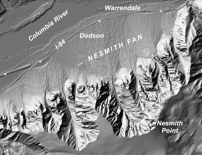
Lidar view of the Nesmith Escarpment and debris fan

The LIDAR view also reveals the alluvial deposits that make up the Nesmith Fan to be a series of hundreds (or even thousands) of overlapping debris flows from the roughly dozen streams that flow from the Nesmith Escarpment, each helping to gradually build the enormous alluvial fan. The wrinkled surface of the fan reveals the hundreds of flood channels that have developed over the millennia as countless debris flows have swept down from the cliffs above.

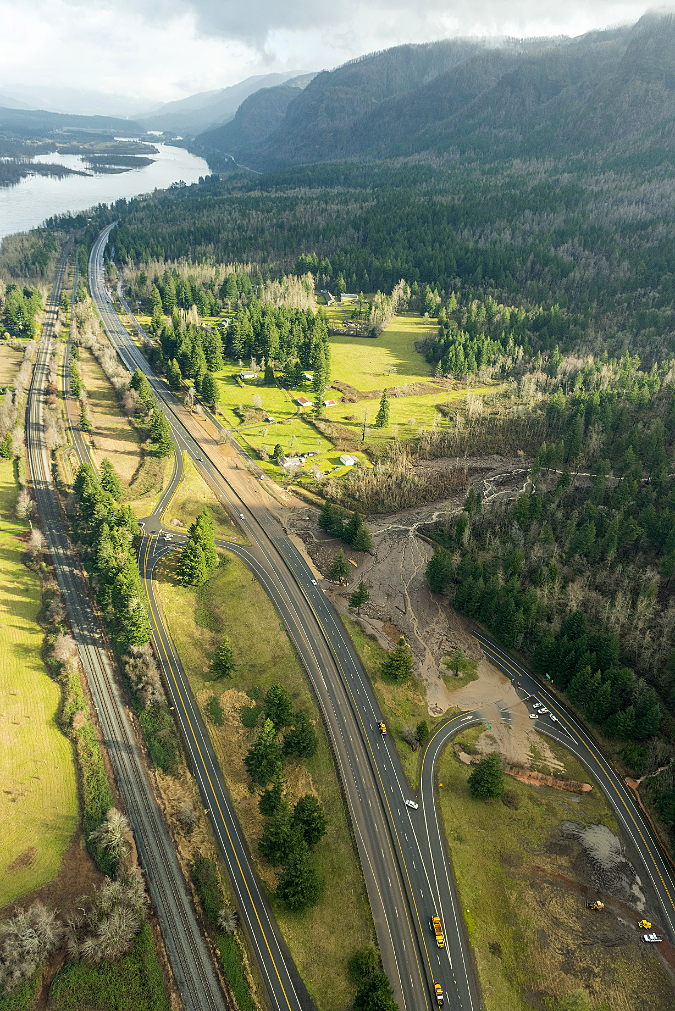
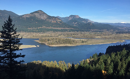
This view (looking east toward Dodson from Ainsworth State Park) shows the vulnerability of I-84 and the Union Pacific Railroad where they cross the 3-mile-wide expanse of the Nesmith Fan. The 2021 debris flows and flooding damage to the Ainsworth interchange can be seen at the center of the photo, where the interstate was temporary closed by the event (ODOT)

[Click here for a large version of this image]

During the very wet winter of 1996, a series of major debris flow roared down from the Nesmith Escarpment, sweeping cars off I-84 and closing the freeway for several days. A train on the Union Pacific line was knocked off its tracks and many home were damaged.

During the event, debris from Leavens Creek, near St. Peters Dome, swept toward the Dodson area, eventually engulfing the Royse house, which was located near the Ainsworth interchange. The scene was shocking, burying the home in debris that rose to the second floor and destroying outbuildings on the Royse farm. You can read Carol Royse’s riveting account of the event on Portland State researcher Kenneth Cruikshank’s excellent web page describing the 1996 debris flows here.

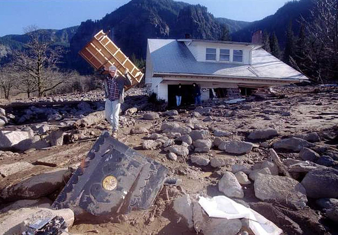
The Royse House in Dodson (with St. Peters Dome beyond) after a series of debris flows on Leavens Creek engulfed the structure in 1996 (The Oregonian)

The Royse home stood half-buried and visible from the freeway for many years, becoming a prominent reminder of the power of the Gorge. By the mid-2000s, a new forest of Red alder and Cottonwood had already enveloped the debris path and the Royse home, eventually obscuring it from view until the Eagle Creek Fire destroyed both the structure and newly established forest in 2017. 

The more recent debris flows in January of this year struck some of the same spots that were impacted in the 1996 and 2001 events. The Tumalt Creek drainage was once again very active, sending debris onto I-84 and closing the freeway. To the west, the Leavens and Bucher creek drainages also sent debris onto the highway and the site of the former Royse home.

As jarring as these changes are to us, this cycle of destruction, rebirth and more destruction has unfolded hundreds of times on the Nesmith Fan. It’s simply part of the ongoing evolution of the landscape.

How do they start?

Debris flows are a mud and rock version of an snow avalanche. They typically begin with oversaturated soils on steep terrain that suddenly liquifies from its own weight. Once it begins to move, the flow can incorporate still more oversaturated soil as it gathers speed, just as a snow avalanche triggers downslope snow to move. The steepness of the terrain is a key factor in how fast a debris flow can move, and on very steep slopes they can reach as much as 100 miles per hour, though they typically slow as the debris reaches the base of the slope and spreads out to form alluvial fans.

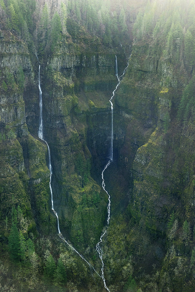
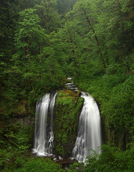
These towering twin cascades where Bucher Creek originates along the Nesmith Escarpment rival Multnomah Falls in height. The impossibly steep terrain here is the source of both the debris and sudden flash floods that have helped build the Nesmith Fan, far below (ODOT)

A heavy rain event can also trigger a debris flow by creating stream flooding that erodes and undermines stream banks, causing debris to slide from canyon walls. This form of debris flow is common in the larger canyons in the Columbia Gorge, but less so on the Nesmith Escarpment, where most of the streams are small and only flow seasonally. Here, it’s the steepness of the slopes and the unstable geology that makes the area so prone to debris flows.

Debris flows are different from landslides. A debris flow is typically quite liquid and fast moving, like cake batter being poured into pan. Landslides are typically slow, with a large mass sliding as a whole, like an omelet sliding from a skillet onto a plate. In the Gorge, landslides are common and mostly occur where the underlying geology is oversaturated and allows the overlying terrain to move. The upper walls of the Nesmith Escarpment are scared by hundreds of landslides, and in the right conditions, these slide can trigger debris flows that spread far beyond the landslide.

What about fires and logging?

A third trigger for debris flows is the sudden removal of the forest overstory. The big trees in our Pacific Northwest forests capture and hold a tremendous amount of rain on their surfaces that never reaches the ground, with some of the moisture directly absorbed by the trees and much of it simply evaporating. Clear cut logging removes this buffer, allowing much more precipitation to suddenly reach the soil, triggering erosion, landslides and debris flows. 

Logging roads are especially impactful by cutting into the soil profile on steep slopes and allowing runoff to infiltrate under the soil layer and destabilized soils. This is well-documented as a source of major landslides in heavily logged areas. Thankfully, most of the forested western end of the Gorge is protected from logging, including the Nesmith Escarpment (though early white settlers logged these areas of the Gorge extensively)

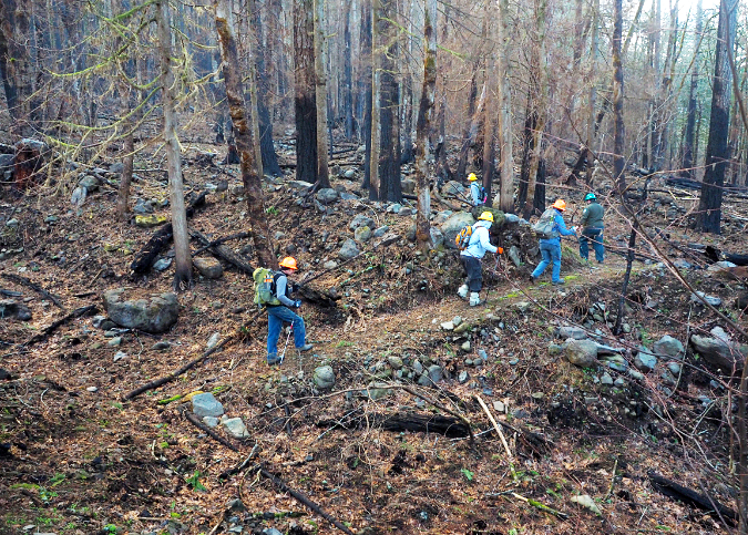
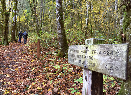
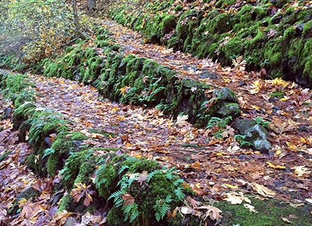
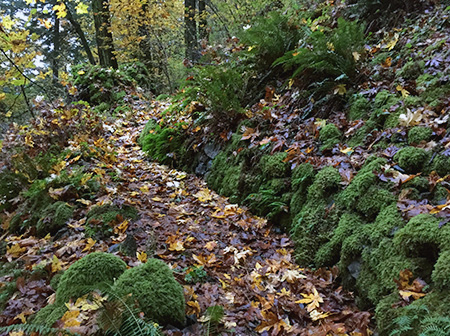
The 2017 Eagle Creek Fire has not only destabilized steep slopes throughout the burn by killing the protective forest cover, it also revealed the tortured landscape of braided flood channels on the Nesmith Fan once hidden under dense vegetation. This image from just after the fire shows a volunteer trail crew scouting Trail 400 where it crosses the fan. The route curves in and out of the dozens of channels and debris piles formed by past flood events

Fire can have a similar effect on runoff when the forest canopy is completely killed. This is why new research shows that attempting to log recently burned areas can have serious effects by disturbing newly exposed soils and worsening the increased erosion that would already result from fires.

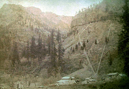
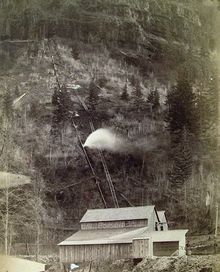
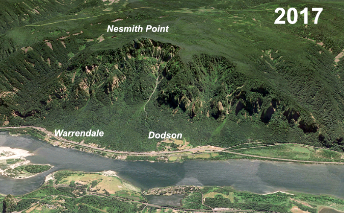
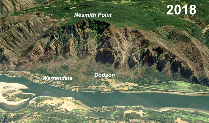
In the Gorge, the 2017 Eagle Creek Fire burned most of the Nesmith Escarpment, raising serious concerns about the debris flow activity accelerating here in the coming decades. The debris flows earlier this year may have been the first major events to have been triggered as much by deforestation from the fire as by oversaturated soils. The following photo pair shows the extent of the burn on the Nesmith Escarpment, with the first photo taken just a few weeks before the fire in 2017 and the second photo taken in 2018, when the fire’s impact was clearly visible.

The January 2021 debris flow

The Oregon Department of Transportation (ODOT) has been making regular flights over the Eagle Creek Fire burn since late 2017 to monitor for potential flooding and landslides. While the main purpose of these surveys is to anticipate impacts on the highway, ODOT is also amassing an invaluable library of historic photos that document the fire and resulting geologic events in a way that has never been done before.

Their most recent flight includes photos from the January 2021 debris flows that tell the story in a way that words cannot match:

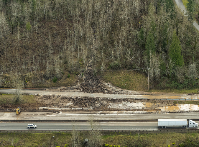
This view looking west toward the Ainsworth Interchange shows how Bucher Creek had completely covered the south half of the interchange and sent mud and debris flowing east on the freeway, itself. The 1996 and 2001 debris flows impacted much of the same area (ODOT)

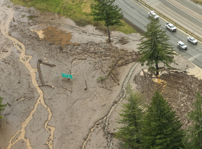
A closer look at the 2021 debris flows where the Ainsworth interchange was overwhelmed with debris. A green highway sign marks what used to be a freeway on-ramp (ODOT)

Bucher creek briefly pushed the lobe of mud and debris in the lower right of this view directly toward the home in the first photo, before changing direction to the path the creek is following in this photo. This is a good example of how accumulated debris regularly forces the streams that carry the debris into new channels. (ODOT)

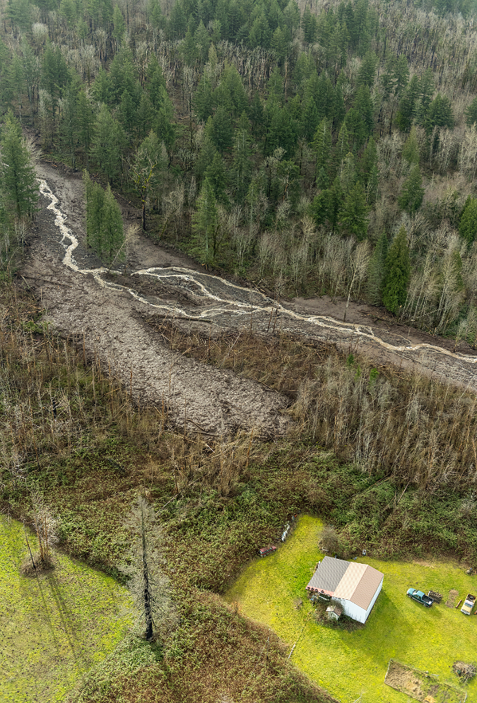
This view looking back at the Bucher Creek debris flow lobe shows just how close it came to the home and outbuildings shown in the previous photo (ODOT)

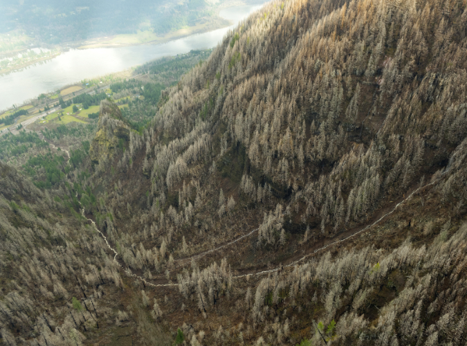
The view down Bucher Creek debris flow toward St. Peters Dome and the Columbia River from near the crest of the Nesmith Escarpment (ODOT)

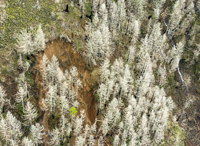
Landslide in burned timber near the crest of the Nesmith Escarpment. This landslide fed debris directly into the Bucher Creek debris flow, and onto the freeway more than 3,500 feet below (ODOT)

What to do?

It’s tempting to wish away future geologic hazards by taking comfort from what we perceive to be more predictable past. After all, the modern Gorge we know has been evolving for more than 13,000 years, and long periods of slope stabilization have marked recent centuries. But can we count on periods of stability in a future that will be shaped by global climate change? 

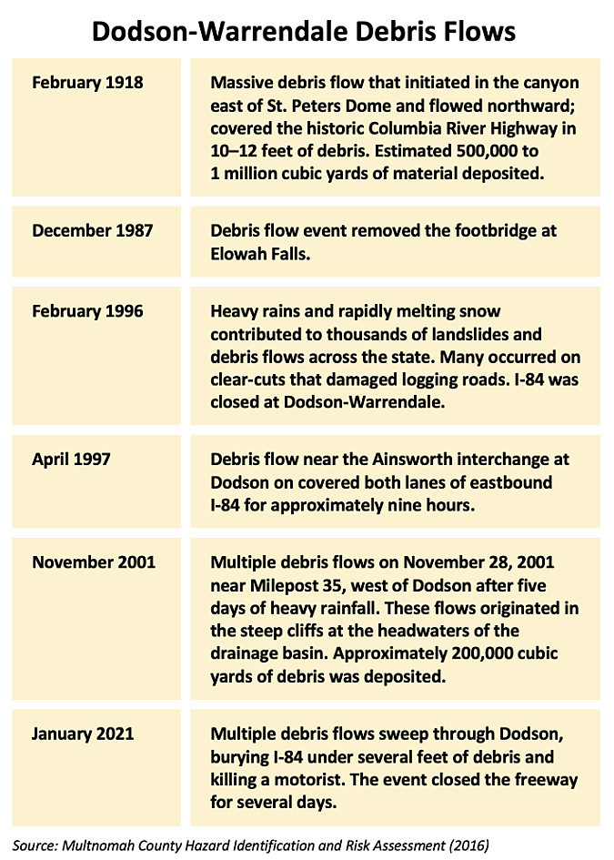
Almost surely not. All indications are for more volatility in both weather and flood events like those that have built the Nesmith Fan. Recent evidence increasingly supports the reality that our landscapes are changing along with the climate. In a 2016 report on landslide risks by Multnomah County, the number of events escalated over the past 25 years, including at the Nesmith Escarpment (see table, below).

The best path for adapting to this reality and becoming more resilient in response to future events is to accept the ongoing risk from the Nesmith Escarpment. In the near-term, this means regularly repairing I-84 and the parallel Union Pacific railroad after flood events that will become increasingly common and disruptive. It also means installing early warning systems along these routes for the traveling public and commers, as well as the residents of the area who live in harm’s way. 

The 2021 debris flow along Tumalt Creek during this year’s series of flood events on the Nesmith Fan was a textbook example of why adapting in the near-term to protect existing infrastructure is a tall order. The following images show just how unpredictable and unmanageable this steam has become for ODOT.

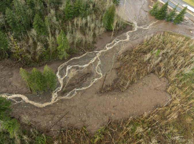
Once Tumalt Creek reaches the foot of the Nesmith Escarpment and begins to flow across the fan, its course continually shifts and changes, making it very difficult to predict where each debris flow event might be headed (ODOT)

A single culvert (above) carries Tumalt Creek under the freeway and frontage road, but the Nesmith Fan is a maze of shifting streambeds by definition, making it nearly impossible to force streams to obey culvert locations (ODOT)

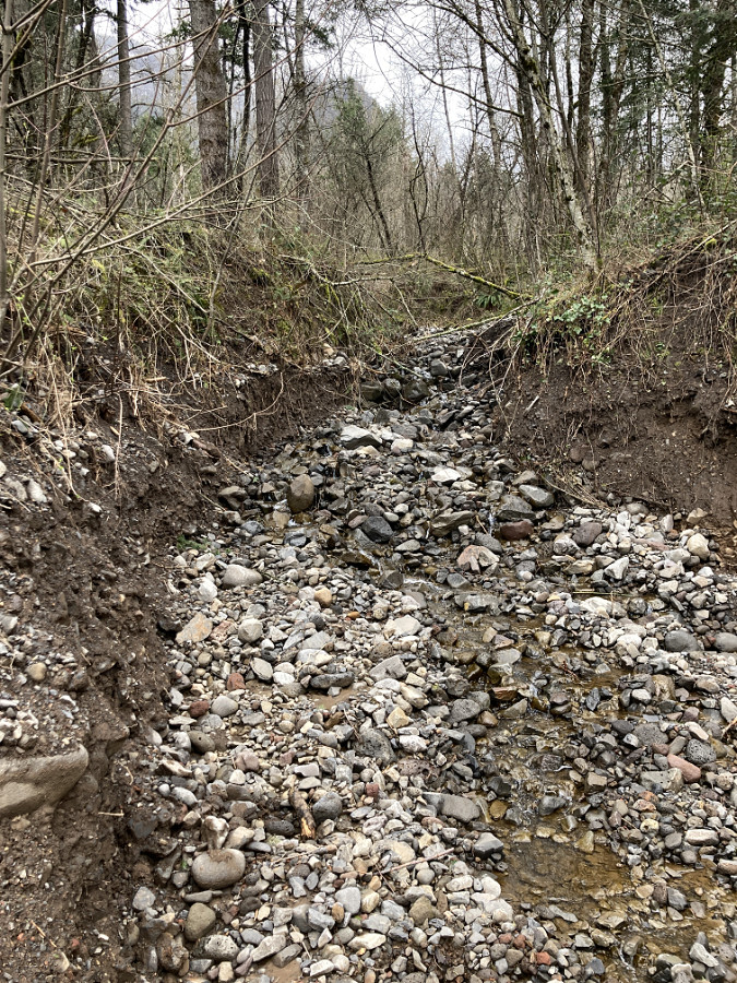
The channel carrying the debris flow on Tumalt Creek that overwhelmed the frontage road and I-84 in February later dried up, with the creek shifting to another channel after the flood (ODOT)

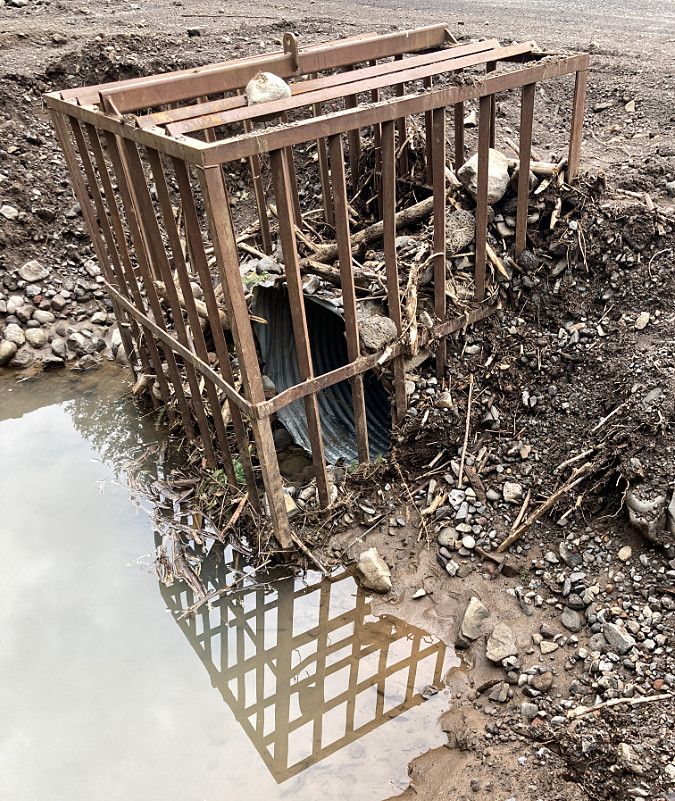
This screen was installed at another culvert that Tumalt Creek has swept through in past debris flow eventsl. While this device might keep small debris flows from overwhelming the culvert, it has no chance against the increasingly large debris flows that we can expect on the Nesmith Fan (ODOT)

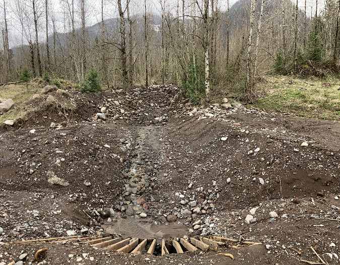
This is the view from the frontage road looking upstream at the large, main culvert intended for Tumalt Creek – though it had shifted out of the channel when this photo was taken a few months after the February event. The flatness of the terrain on the Nesmith Fan is evident here, with no obvious stream chanel except for the grading and contouring by highway crews (ODOT)

Adapting to a new reality

In the long term, coping with debris flows also means facing some tough questions for those who live on the Nesmith Fan. For some, it’s a place where families have settled for generations. For others, it’s a dream home they’ve put their life savings into on the Columbia River in the heart of the Gorge. But for anyone who lives here, the risks are real and growing – as the death of a local resident in this year’s debris flows reminds us.

Across the country, climate change and rising sea levels are impacting millions of homes and businesses built in floodplains formerly classified as “100-year”, but now seeing regular flooding. In the past, the U.S. Government has provided public flood insurance for those living or operating a business in a flood zone, but the increasing frequency of catastrophic events in flood and hurricane-prone regions like the Mississippi Valley, Texas, Florida and Carolina coasts is pushing federal flood insurance premiums sharply up. This does not bode well for those living and working in hazard zones in the Pacific Northwest, including the rural communities scattered across the Nesmith Fan.

Notices like this will become a way of life for Nesmith Fan residents in coming years

In some places along the Mississippi Valley, the federal government has begun simply relocating homes, and even whole towns, rather than rebuilding them in harm’s way. Could this be a model for the Nesmith Fan? Possibly, though most of the private homes in the path of debris flows are not in the flood plain, and may not be eligible for any form of subsidized federal insurance or assistance, short of a disaster.

A more direct approach that could be taken at the state level is a simple buy-out, over time. Where flood-prone areas in other parts of the country might simply have value as farm or grazing land, the Gorge is a world class scenic area, and both public land agencies and non-profits are actively acquiring land for conservation and public use. As Gorge locations go, it’s hard to find a spot as spectacular as the Nesmith Fan and the escarpment that rises above it.

Already, the Forest Service and Oregon State Parks have acquired land on the Nesmith Fan for recreation and to provide habitat under the Columbia River Gorge National Scenic Area provisions, including at least two parcels with coveted river access. Permanent funding of the federal Land and Water Conservation Fund last year should also help jump-start public acquisitions in the Gorge that have stalled in recent years, and could help spur land owners considering their options.

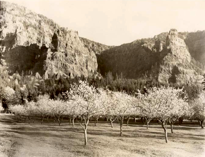
Katanai Rock (left) and St. Peters Dome (right) rise above orchards at Dodson in this 1940s view from the old Columbia River Highway

Recent events are surely changing the dynamic for landowners in the Gorge, as well. Would some residents living on the Nesmith Fan be more open to a buy-out after witnessing the devastation of last year’s debris flows, knowing that more are likely to come in the wake of the Eagle Creek Fire? Probably. Others – especially the string of luxury homes along the Columbia River – might be more motivated by legacy, and for these folks, non-profit conservation trusts and easements could be a tool for transitioning private land into public ownership over time.

In the meantime, expect more flooding, debris flows and periodic closures of I-84 during the rainy months. And probably more fires in summer, too. This is the new normal in the Realm of St. Peter, after all, and it’s a cycle that will continue for all our lifetimes, and beyond.

Rediscovering McCord Creek!

McCord Creek takes on more subtle hues in winter

McCord Creek takes on more subtle hues in winter

Beautiful McCord Creek boasts a pair of impressive waterfalls that are among the most photogenic in the Columbia River Gorge. The falls are tucked into John B. Yeon State Park, a lesser-known park located about halfway between Multnomah Falls and Cascade Locks.

The rustic CCC-era trails to McCord Creek’s waterfalls have been “discovered” in recent years from spring through fall by crowds of weekend hikers. Yet, the area is surprisingly un-crowded during the wet winter months, from late fall through early spring, and the muted winter tones are just as beautiful.

The area also has a long and fascinating human history that is on display throughout the hike, if you know where to look. This article provides a guide to both the trail and the history of the McCord Creek area.

Frank Warren's salmon cannery (site of today's Warrendale) in 1902

Frank Warren’s salmon cannery (site of today’s Warrendale) in 1902

The human history in this part of the Gorge stretches back thousands of years, as the river was home to a thriving culture of Native American peoples.

The Upper Chinookan people of the Columbia River Gorge fished the legendary autumn salmon runs and picked huckleberries and other wild fruits and forage before moving away from the river during the often harsh winters that we know so well today. An especially elaborate example of the mysterious stone pits thought to be built by native people for ceremonial purposes can still be found high above McCord Creek, on Wauneka Point.

White settlement came to the Gorge in the 1800s, and ushered in an era of profound tragedy for the native people, with epidemics of measles and other European diseases decimating native populations, and white settlement displacing native peoples from places they had inhabited for millennia. It’s an uncomfortable reality to confront today, but also important to never forget as we try to understand our history.

White settlers were equally destructive for the land and natural resources, as well. In a matter of a few decades, the Gorge slopes were almost completely logged of ancient forests and giant fish wheels built along the river were part of the commercial overfishing that nearly collapsed the salmon runs that had sustained Native Americans here for thousands of years.

Frank and Anna Warren in the early 1900s

Frank and Anna Warren in the early 1900s

Frank Warren was among the prominent industrialists operating fish wheels to supply a cannery he built at Warrendale. Today, only a residential district by that name remains to mark the site, just downstream from McCord Creek.

In the heyday of the Columbia River canneries at the turn of the 20th Century, canned salmon from the Warren packing company was exported around the world, and Columbia River canned salmon was as ubiquitous as cans of tuna are in our supermarkets today. But overfishing by gill nets, fish traps and fish wheels nearly destroyed the salmon runs. Fish wheels were finally outlawed by the 1930s, as the canning industry on the Columbia continued its decline. The last salmon cannery on the river closed in the 1970s.

1890s Harpers Weekly illustration of a Columbia River fish wheel

1890s Harpers Weekly illustration of a Columbia River fish wheel

Warren’s packing business made him a millionaire, and he and his wife Anna celebrated their 40th anniversary in style with a 3-month European tour in 1912. For their return trip, the Warrens reserved a first-class stateroom on the maiden voyage of the RMS Titanic.

Anna Warren’s riveting account of the Titanic disaster in April 1912 was featured in the Morning Oregonian twelve days after the incident, creating a local sensation. Her tragic story recounted how her husband Frank helped her onto a lifeboat, with Anna assuming he had followed her in. Instead, when she looked back, she saw Frank helping other women into the boats.

At the time Anna Warren’s account was published, Frank Warren’s fate was still unknown, but he was later identified as among the more than 1,500 who perished that night. Anna Warren was one of just 710 survivors of the disaster.

Myron Kelly's pulp mill at McCord Creek in the 1890s

Myron Kelly’s pulp mill at McCord Creek in the 1890s

At about the same time that Frank Warren was operating his Warrendale cannery in the late 1800s, another settler by the name of Myron Kelly was operating a small pulp mill near McCord Creek. Kelly’s mill used a pair of 400-foot long, riveted steel penstocks to power the pulp manufacturing. Though the mill is long gone, portions of the penstocks still survive. They are clearly visible in the 1890s view of the mill, above.

The penstocks were fed with water from McCord Creek, diverted from above the waterfalls, and routed to the penstocks along the cliff-top ledge we now use as a hiking trail. Kelly used a natural break between basalt layers to blast out the ledge, and hardware from the pipe system is still found throughout the cliff area today. Black cottonwood trees — the same we see lining the river today — provided the raw material for making pulp.

This 1890s photo shows water spouting from the long penstock that drove Myron Kelly's pulp mill

This 1890s photo shows water spouting from the long penstock that drove Myron Kelly’s pulp mill

Surviving portions of the two penstocks are prominently crossed by the trail to Upper McCord Creek Falls, along with other relics sprinkled through the forest. The large wood water cistern located near McCord Creek trailhead is not from the Kelly pulp mill era, surprisingly, and was added later to supply water to area homes.

The early industrial settlements in the Gorge relied on railroads and ships for transport, as there was no road until the early 1900s. That changed in 1916, when the new Columbia River Highway was dedicated with much fanfare. The highway is still famous, cherished by millions of visitors over the past century for its careful attention to the landscape and surrounding Gorge scenery. Perhaps most iconic are its string of graceful bridges.

Columbia River Highway bridge at McCord Creek under construction in 1915 (Wauneka Point towers above)

Columbia River Highway bridge at McCord Creek under construction in 1915 (Wauneka Point towers above)

The original highway bridge at McCord Creek was completed in 1915, and while it wasn’t as graceful as some of the more famous arched bridges, it was nonetheless a spectacular structure. Early travelers not only had a front-row view of Elowah Falls on McCord Creek, but also a sweeping vista across the Columbia to Beacon Rock and the mountains that rise along the Washington side of the Gorge.

The original McCord Creek Bridge was among the longest along the old highway at 365 feet. The old structure was durable enough to be incorporated into the first “modern” highway in the Gorge in the 1950s, when much of the original Columbia River Highway was bypassed. The original McCord Creek Bridge was simply expanded to carry the wider road, and later a twin structure was built to accommodate the development of today’s freeway. The original bridge structure was finally replaced in 1987 with a new bridge, after 70 years of service.

Completed McCord Creek bridge in 1915, with the Kelly pulp mill conduits visible in the cliffs high above, and Elowah Falls behind the bridge

Completed McCord Creek bridge in 1915, with the Kelly pulp mill conduits visible in the cliffs high above, and Elowah Falls behind the bridge

The new McCord Creek Bridge in the 1920s as it appeared from the cliffs above Elowah Falls

The new McCord Creek Bridge in the 1920s as it appeared from the cliffs above Elowah Falls

By the 1930s, the New Deal programs of Franklin D. Roosevelt’s national recovery effort brought the Civilian Conservation Corps (CCC) to the Gorge. Many of the trails we enjoy today were built — or rebuilt — by the CCC, including the McCord Creek trail.

The CCC crews were expert trail builders, and made quick work of the steep Gorge slopes with carefully graded switchbacks constructed with miles of hand-built, rustic stone retaining walls. The original trail at McCord Creek began at the east end of the old highway bridge, traversed to dramatic viewpoints of Elowah Falls, then crossed McCord Creek to climb the east shoulder of the canyon to the upper falls.

Civilian Conservation Corps crew building the catwalk section of the McCord Creek Trail in 1936 (highway bridge visible in lower left corner of photo)

Civilian Conservation Corps crew building the catwalk section of the McCord Creek Trail in 1936 (highway bridge visible in lower left corner of photo)

It was here that the CCC trail builders seized upon the route of Myron Kelly’s penstock conduit around the towering cliffs above Elowah Falls. The photo above shows crews clearing the ledge in 1936 to repurpose the route as a bold new hiking trail.

The galvanized steel handrails that now give some assurance to hikers along this airy catwalk are not mentioned in a fairly detailed 1936 Daily Oregonian story describing the new trail. These were probably added in the 1950s, when similar railings were installed in other parks around the Gorge — and it’s easy to see why this retrofit was needed as you walk along the 300-foot brink!

Beacon Rock and the McCord Creek Bridge as they appeared from the original CCC trail to Elowah Falls

Beacon Rock and the McCord Creek Bridge as they appeared from the original CCC trail to Elowah Falls

The 1936 Daily Oregonian article also mentions one of the more famous features of the area during the early days of the Columbia River Highway. The McCord Creek Bridge construction in 1915 had unearthed a large petrified tree near the east end of the bridge, embedded in the road cut. The tree became a popular feature along the old road, and also marked the start of the McCord Creek trail.

The whereabouts of the petrified tree are unknown today, as it must have been moved (or destroyed) when the modern highway was constructed in the 1950s. Curious Gorge author Scott Cook speculates that it may have found its way to Cascade Locks, where a petrified log now sits on display at the Marine Park. Petrified logs are not uncommon in this part of the Gorge, however, so the fate of this most famous log may never be known for certain.

Update: Scott Cook has located the petrified tree! It was apparently shipped to the University of Oregon Natural History Museum when the modern freeway was built, and placed next to a replica of the Willamette Meteorite. Scott tells me that ODOT historic highway staff approached museum officials a couple of years ago about moving the tree back to its original home (of a few million years), but it’s unclear if that idea gained any traction. The beautiful new McCord Creek bridge sure seems like an appropriate home for the old tree! Stay tuned – I’ll report any news on the subject as it comes.

This petrified log was located at the east end of the McCord Creek bridge, near the original trailhead

This petrified log was located at the east end of the McCord Creek bridge, near the original trailhead

The human history of the McCord Creek area has taken another dramatic turn in recent years with the construction of the Historic Columbia River Highway (HCRH) State Trail. The new bike and pedestrian route is an ambitious, decades-long effort by the State of Oregon to restore lost sections of the original highway, eventually re-connecting the entire original route from Troutdale to The Dalles.

In 2012, construction of the HCRH State Trail section from John B. Yeon State Park to Tanner Creek was in full swing, and featured a handsome new bridge over McCord Creek that rivals the original highway bridges in its design and attention to detail.

The new Historic Columbia River Highway state trail bridge at McCord Creek under construction in 2012

The new Historic Columbia River Highway state trail bridge at McCord Creek under construction in 2012

The completion of this new segment of the HCRH State Trail has opened loop high opportunities in the McCord Creek area, as well as the opportunity to bike and hike — as described below in this article.

Exploring the Trail Secrets of McCord Creek

A young family enjoying the McCord Creek Trail in late autumn

A young family enjoying the McCord Creek Trail in late autumn

Now that you know some of the history of McCord Creek, it’s time to explore the trail! This is a half-day hike for most, so makes for a great option during the short days of winter, when most higher elevation trails are snowed in. It’s also a great family hike, with lots to look at and modest grades throughout, thanks to careful design by its CCC builders.

Like most Gorge trails, the hike has cliffs, poison oak and ticks, so keep an eye on small kids, leash your dog, learn to identify and avoid poison oak and do a tick check when you get home. One of the added advantages of doing this hike during the winter months is that poison oak leaves have dropped, greatly reducing the possibility of bringing home an itchy rash from your hike! Ticks are also much less active in winter — and not particularly prevalent in this particular area — though you should always do a tick check after hiking in the Gorge.

McCord Creek Trail map

McCord Creek Trail map

[click here for a larger, printable map]

The hike starts at the John B. Yeon trailhead (driving instructions at the end of this article), and after passing the old wooden cistern mentioned above, you immediately reach the first poorly-signed junction. The trail to the right heads off to Nesmith Point, so continue straight (left) instead, past an empty signpost and traverse above the trailhead parking area.

Soon, the trail begins a very gradual climb on what is actually an old roadbed, now just a very wide and rustic path. This section of trail was opened sometime after the modern freeway was constructed in the 1950s, and the original trailhead for the McCord Creek trail relocated from its old location on the east side of the creek.

The first of several confusing signs along the trail…

The first of several confusing signs along the trail…

At about one-half mile from the trailhead, the old roadbed ends at a “T” junction with the original CCC trail and another confusing signpost. From this point in the hike, the trip has two forks, with up-and-back spurs to follow, one to each of the two waterfalls. The best way to enjoy the hike is to go right at this junction, and continue climbing toward Upper McCord Creek Falls as your first destination.

As you climb the 1.2 miles to the upper falls, watch for the beautifully constructed stone retaining walls that line much of the trail. They are now cloaked in moss and licorice fern, but have held up amazingly well since the stones were first placed almost 80 years ago by CCC workers.

Legacy of the CCC - rustic stone retaining walls like these are found throughout the hike

Legacy of the CCC – rustic stone retaining walls like these are found throughout the hike

After several switchbacks through steep forest, you will encounter the remains of the old pulp mill penstock pipes. One is located at the end of a switchback, the other crosses the main trail.

Look closely at the second pipe, and you can see the doomed efforts of some early trail crew to actually cut through the surprisingly solid pipe! Up close, you can also see the thousands of rivets used to assemble pipes of this kind in the late 1800s in a way that could withstand the intense water pressure.

Myron Kelly's sturdy penstock pipes still survive along the upper trail

Myron Kelly’s sturdy penstock pipes still survive along the upper trail

The trail passes through a couple more switchbacks beyond the penstock pipes before reaching the spectacular and exhilarating catwalk section, some 300 dizzying feet above McCord Creek. The handrail makes this section very safe, so take the time to look for traces of the old mill conduit that once carried water from McCord Creek around this ledge — there are old bolts and bits of pipe if you watch closely.

The catwalk section has reassuring railing atop the 300-foot cliffs

The catwalk section has reassuring railing atop the 300-foot cliffs

Traces of the old waterworks are still visible on the upper trail

Traces of the old waterworks are still visible on the upper trail

The views from the cliffs are also impressive. On most days, Aldrich and Table Mountains on the Washington side of the Columbia River dominate the horizon, but on clear days, the very top of Mount Adams can also be seen. Further on, the catwalk section of trail also allows a birds-eye view of Elowah Falls dropping into its huge amphitheater, far below.

Sweeping cliff-top views stretch across the Columbia to Aldrich and Table Mountains -- and the very top of Mount Adams, in the distance

Sweeping cliff-top views stretch across the Columbia to Aldrich and Table Mountains — and the very top of Mount Adams, in the distance

If you happen to be hiking the trail during the busier months of May or early June, you’ll have an extra treat on the catwalk section, as the rocks are lined with tiny, hanging wildflowers that cling to the cliffs. Conversely, if you hike the trail in very cold winter weather, you’ll find a spectacular array of icicles along this section (making the handrail that much more appreciated!)

The catwalk portion of the hike ends abruptly when the trail disappears into the lush upper canyon of McCord Creek. Just a few steps into this beautiful rainforest, the view suddenly opens to the twin cascades of Upper McCord Creek Falls. This is an idyllic spot to stop for lunch and photographs. The trail continues a few hundred yards to the edge of McCord Creek, just above the falls, where the intake for Myron Kelly’s pulp plant was apparently located.

Lovely Upper McCord Creek Falls

Lovely Upper McCord Creek Falls

To complete the second leg of the hike, retrace your route down to the “T” junction and continue straight (right) in a traverse across a mossy talus field. Soon, the trail abruptly drops into the lower McCord Creek canyon with another series of switchbacks. In this section, you’ll see old cable railings at an overgrown viewpoint that dates to the 1940s or 50s. You will also have a view down to the new McCord Creek Bridge on the HCRH State Trail, far below.

The lower trail soon traverses above noisy McCord Creek before arriving at the spectacular base of 213-foot Elowah Falls. The trail crosses the stream on a wooden footbridge here, and during the rainy season, expect to get wet — the spray is impressive!

This pretty section of the original CCC trail is now bypassed, but fun to explore

This pretty section of the original CCC trail is now bypassed, but fun to explore

You can do the fragile canyon ecosystem at Elowah Falls a favor in this area by not scrambling up the various boot paths that have formed here. Most are dead-ends left by hiking newbies that go nowhere, but are beginning to have an impact on the landscape.

Instead, there’s a better way to visit a lesser-visited viewpoint of the falls. Simply continue beyond the footbridge and begin traversing downstream along the canyon for about one-quarter mile. As the trail begins to curve away from the stream, watch for an obvious path on the right and above the main trail. This is a bypassed section of the original trail, and it’s in excellent shape for exploring.

You can follow the old tread past a couple of switchbacks, then to a fork, where a short spur leads left to a spectacular, boulder-top view of the Elowah Falls, framed by bigleaf maples. The main portion of the old tread continues a bit further, then dead-ends at another great view of the falls, where you can also see the modern trail and footbridge, below.

Elowah Falls from a viewpoint along the old trail section

Elowah Falls from a viewpoint along the old trail section

If you do explore this abandoned section of trail, please stay on the tread — it’s obvious and easy to follow, with much of it still lined with CCC stone retaining walls. In recent years, boot paths to the viewpoints on the old trail have formed from the modern trail, below, so be sure not to reinforce these and simply retrace your steps along the old route to return to the main trail.

If you’re looking for a longer hike and more variety, you can also continue east from Elowah Falls for about a mile to the newly completed HCRH State Trail, where you’ll find a signpost marking the junction. Turn left on the wide, paved trail and follow it 1.2 miles back to the Yeon Trailhead, passing the impressive new McCord Creek Bridge along the way — another nice stop along the hike. This section of the new HCRH State Trail is noisy, as it follows the freeway closely, but it’s an interesting and new way to appreciate the Gorge from a different perspective.

How to Get There

From Portland, take I-84 to Ainsworth (Exit 35), a few miles east of Multnomah Falls and the eastern access to the drivable western section of the Historic Columbia River Highway. Turn left at the first intersection, then almost immediately turn right onto a frontage road where signs points to Warrendale. From here, continue east on the frontage road to the Yeon State Park trailhead, where the frontage road terminates at an eastbound freeway ramp. To return to Portland, follow the frontage road west to the Ainsworth interchange, and follow signs to Portland.

No trailhead permits are required here, and no restrooms or water are provided (note: water and restrooms are available just west of the Ainsworth interchange, at Ainsworth State Park). Dogs must be leashed in this state park! At least two dogs have had to be rescued by search and rescue teams in the Gorge after falling from cliffs this year because of careless owners who took exception to posted rules. Please set an example and respect this rule… and enjoy your trip!
______________

Special thanks to Scott Cook for his help on this article! Be sure to pick up a copy of Scott’s new guide to Portland: PDXccentric: the odyssey of Portland oddities! You can learn more on the PDXccentric Facebook page.

Million Dollar View – Postscript

Beacon Rock rising above the Columbia, as viewed from the Oregon side

In March 2009, I posted this article about local hostility toward the public that has emerged in the Warrendale community, opposite Beacon Rock on the Columbia River. Last summer, James Ellis Koch, a 68-year-old resident in the area was arrested for firing a rifle and shotgun at fisherman anchored offshore his riverfront property, terrorizing the four men onboard.

The original article has now been updated with postscripts detailing the incident, and pointed observations on Warrendale’s vigilante culture by the sentencing Multnomah County judge Janice Wilson.

The Million Dollar View

Beacon Rock rising above the Columbia, as viewed from the Oregon side

Beacon Rock rising above the Columbia, as viewed from the Oregon side

Beacon Rock rises nearly 1,000 feet above the Columbia River, and forms the nucleus of some of the finest park lands on the Washington side of the Columbia Gorge. The famous network of catwalks and stairways installed on Beacon Rock in the 1920s leads thousands of visitors to the airy summit each year to marvel at the view.

Nineteenth-century engraving of an early Beacon Rock scene

Nineteenth-century engraving of an early Beacon Rock scene

Beacon Rock, itself, is a testament to conservation, having been saved from an early 1900s scheme to actually mine the monolith for quarry stone. Today, it is among the most visited — and best loved — spots in the Gorge, with campgrounds, picnic areas and an impressive network of hiking and bicycling trails. But when the park boundaries were laid out for Beacon Rock, the Oregon side of the river was left out of the equation.

In the early days of white settlement, fish wheels operated in the shadow of Beacon Rock, along this section of the Oregon shore, harvesting salmon from the vast migrations that moved up the river.

Early settler Frank Warren operated a cannery on the site, and the town that grew around his operation became known as Warrendale. (editor’s note: Frank Warren was the only Oregon resident known to have perished on the Titanic; his wife Anna was among the few to escape in a lifeboat, and survived, while her husband stayed behind on the ship to help other women and children into lifeboats)

Present-day view of Beacon Rock from the Oregon side

Present-day view of Beacon Rock from the Oregon side

After the demise of fish wheels and the Warren cannery in the early 1900s, Warrendale began a slow slide into obscurity. Today, the former town site has largely been replaced by Interstate-84, and a dozen homes now occupy this remnant of private parcels along the Columbia River.

This is where the story gets a bit ugly. Like all inholdings in the Gorge and around Mount Hood, the river front homes in Warrendale suffer from trespassing — both by well-meaning visitors simply trying to find access to the river, and by less courteous visitors who clearly don’t respect the numerous private property postings.

The lure of the river here is undeniable. Beacon Rock towers across the Columbia, and sandy beaches line the river in summer and fall. Yet, no public access exists along this stretch of Oregon shoreline, and thus the tension between land owners and visitors.

Tensions run high in Warrendale as property owners struggle to block visitors from trespassing to reach Columbia River beaches

Tensions run high in Warrendale as property owners struggle to block visitors from trespassing to reach Columbia River beaches

Some landowners have taken drastic steps, in response, posting profane signs that have shocked more than a few families who have stumbled into Warrendale. Less confrontational signs show up everywhere, making it abundantly clear that the public is not welcome in this community.

Even the official signposts in Warrendale bear blunt warnings for visitors

Even the official signposts in Warrendale bear blunt warnings for visitors

There’s no doubt that the view from these homes is among the most spectacular anywhere, but in the long term, should this stretch of beach be reserved for just a few? After all, were it not for the fish wheel and cannery that once stood here, this would likely be public land, with public access for all. Is it possible that in the long term, this unique spot can be dedicated to public access?

Not in the near term, in all likelihood. Though the Columbia River Gorge National Scenic Area (CRGNSA) receives funds each year from Congress for the express purpose of acquiring private parcels in critical locations, most acquisitions are for properties that directly abut federal or state lands, or are in pristine condition. The dozen homes in Warrendale are neither — they are separated from public lands by Interstate-84 and largely developed.

One viable option for the CRGNSA is to follow the lead of private land acquisition organizations, like the Nature Conservancy and Trust for Public Lands, and purchase conservation easements or living trusts for these properties. For private conservation groups, these have been valuable real estate tools for eventually bringing private lands into the public realm. Another option is a partnership between the CRGNSA and one of these organizations to reach a similar result.

It’s not too soon for the CRGNSA to be thinking about this possibility. This is a million dollar view that deserves to be enjoyed by all, not just a few.

Postscript: In June 2010, one of the riverfront homeowners in Warrendale, 68-year-old James Koch, threatened four salmon fishermen who were anchored for the night in their boat just offshore, then fired rifle shots toward the boat. After his arrest by Multnomah County authorities, he was found guilty of felony unlawful use of a weapon, misdemeanor menacing and misdemeanor recklessly endangering other.

During his trial, he called on neighbors who testified about the public encroaching on their riverfront property. In this November 3, 2010 Oregonian article, one of the fishermen, Steve Bruce, said he was “sickened by that attitude. It’s not just him (Koch), they all feel that they own the land under the water.”

Koch could face prison time, pending sentencing, and will lose is right to own or operate firearms.

Second Postscript: In November 2010, James Ellis Koch was sentenced in Multnomah County court to 60 days jail time and three years probation for firing weapons at four salmon fishermen who were anchored for the night in their boat just offshore from his Warrendale property.

In this November 19, 2010 Oregonian article, Judge Janice Wilson took issue not only with Koch’s unrepentant attitude, but also with the vigilante culture that exists in the Warrendale community. From the article:

James Koch also offered these words: “I’m sorry for whatever happened, the stuff that happened out there that evening.”

That prompted this response from the judge. “(That) is not an apology,” she said. “It’s actually worse than nothing. It’s an anti-apology.”

The judge said Koch wasn’t justified that night in the slightest. The fishermen weren’t making noise, they weren’t drinking and they were lawfully camping on the water. The judge said she was concerned about Koch’s attitude, as well as the attitudes of his neighbors.

Neighbors testified that they are so wary of strangers and crime that they stop unknown drivers traveling through their remote east county hamlet. Yet on the night Koch fired his weapons, they didn’t look to see what was going on because shots in their neighborhood aren’t unusual.

“I don’t know what that says about that neighborhood … but it’s a little bit scary,” the judge said. “… This vigilante culture in this neighborhood is of grave concern to the court.