Proposal: Oneonta Loop Trail

Beautiful Middle Oneonta Falls

The Columbia River Gorge is so rich with natural beauty that it’s pretty hard to pick favorites. Yet, when it comes to graceful waterfalls cascading through verdant, rainforest canyons, Oneonta Creek is near the top of my list. A previous article on this blog presented a new vision for managing access to stunning Oneonta Gorge and restoring the historic Oneonta Tunnel. This article examines Oneonta Canyon above the Oneonta Gorge, where more waterfalls and rugged beauty brought thousands to the trails here before the 2017 Eagle Creek Fire.

Iconic Triple Falls on Oneonta Creek

The fire has since changed the Gorge landscape for most of our lifetimes, and the forest is just beginning a post-fire recovery cycle that has unfolded here countless times over the millennia. But while the starkness of the burned landscape is something that we are still adjusting to, the fire gives us a once-in-century opportunity to rethink and rebalance how we recreate in the Gorge.

Oneonta Creek experienced some of the most intense burning during the fire, and almost none of the dense forest canopy survived, and still the forest has already begun to restore itself. What can we do to restore our human presence at Oneonta in a way that will be sustainable for the next century, leaving a legacy for future generations like the one that we inherited?

Before the 2017 Fire: Signs of Stress

The spectacular scenery along the Oneonta Creek was already drawing huge, unsustainable crowds of hikers well before the Eagle Creek Fire roared through Oneonta Canyon, and the visible impacts were everywhere. Some of the impact was on the human environment, including the very trails and bridges that brought hikers into Oneonta Canyon. And some of the impact was on the land, itself, with hikers straying from developed trails to create destructive social paths and shortcuts in many spots. These informal trails had become badly eroded, often undermining the main trails, themselves. 

Social trail damage near the lower Oneonta Creek footbridge

One place where these impacts escalated alarmingly in the years before the fire was the lower footbridge on Oneonta Creek, located just above Oneonta Falls and just below Oneonta Bridge Falls. As shown in the photo above, crowds of hikers had carved a new path to a pool in the creek at the west abutment of the bridge, stripping away fragile vegetation and filling the pool with eroded debris.

The photo below shows how this social path has not only destroyed the thin layer of soil and forest understory on the slopes of Oneonta Creek, but was also undermining the main trail, itself, which was gradually sliding down the slope.

Social trail eroding both the slope and the shoulder of the main trail (on the left)

Even the lower Oneonta footbridge was in trouble before the fire. The Forest Service began posting a warning on the bridge a few years before the fire limiting it to one hiker at a time, yet another reminder of the serious disinvestment we have been making in our Gorge trails for the past thirty years. The rapid growth in visitors during this same period only increased the impact on structures like this, which were long overdue for repair or replacement.

Warning sign for hikers approaching the lower Oneonta footbridge

Meanwhile, at the east end of the lower Oneonta Bridge, curious crowds had pushed a new social path upstream, past Oneonta Bridge Falls (below). Social paths form when hikers head off-trail in search of a new viewpoint or water feature. When more hikers the steps of the first, the increasing foot traffic gradually formalizes social until they become hard to distinguish from legitimate trails — except that they are rarely “built” in a way that is sustainable, and often bring serious harm to the landscape.

Social trail heading toward Middle Oneonta Falls from the lower Oneonta Creek bridge

Meanwhile, things were getting worse on the east side of the lower Oneonta Bridge, too, where hikers had cut the short switchback just above the bridge (below) to the point that it began collapsing before the fire closed the area to the public. Why do people do this? Mostly, it’s ignorance, inexperience and overcrowding, and often by children who are not getting needed guidance from parents on why this is not okay.

Heavy damage from shortcutting on this switchback at the east end of the lower Oneonta Creek bridge

Heading beyond the lower Oneonta bridge, another major social path had formed on the west side of the creek (below), where hikers had created a long shortcut directly down the canyon slope where a long switchback exists on the main trail. The damage here was obvious and quite recent when this photo was taken about 18 months before the fire. When social paths become this prominent, the damage begins to spiral, with new or inexperienced hikers mistaking them for a legitimate route, and further compounding the problem with still more foot traffic. The overcrowding on the Oneonta Trail only added to the spiraling effect.

Hikers shortcutting this switchback have created a new social trail nearly as wide as the main Oneonta Creek trail

While hikers were causing the bulk of the impact before the fire, Mother Nature was busy in Oneonta Canyon, too. The photo below was taken after the 2017 fire, and reveals a major landslide that began moving years before the fire. The slide extends from Oneonta Creek (where it has left a pile of trees and debris visible in this photo) to the cliffs well above Oneonta Trail. A fifty-yard section of the trail was erased by the slide, with several efforts in the years just before the fire to stabilize a new route above the old trail.

Landslide along the middle section of Oneonta Creek that threatens long-term viability of the current trail

Here’s a view (below) of the landslide looking downhill toward Oneonta Creek from where the original Oneonta Creek Trail was once located. The big trees still standing in the path of the landslide in this view were burned in the fire, which will further destabilize this slope and allow the slide to accelerate in coming years.

Looking down the landslide toward Oneonta Creek in 2015, before the fire

When the original section of the Oneonta Trail was swept away by the landslide, the Forest Service built this set of stairs (below) to a new crossing of the slide, about 30 yards uphill from where the old trail had been.

Bypass trail built to temporarily navigate the Oneonta Trail landslide

This photo (below) shows the new, temporary crossing of the slide as it existed before the fire, but volunteer trail crews visiting the Oneonta Trail earlier this year report that this temporary route has also become eroded since the fire. The continued instability of the landslide raises real questions about whether a safe route can be maintained here in the near-term.

Wide angle view of the temporary route built across the landslide a few years before the 2017 Eagle Creek Fire

Landslides like this are an ongoing part of the Gorge geology, but in this case, it also marks a spot where an increasingly busy social path dropped down to Middle Oneonta Falls. The growing traffic to this off-trail falls was already taking its toll on the terrain before the slide. So, was the landslide triggered by erosion along the social path? There’s no way to know, but it’s certainly possible that the social path contributed to the sudden instability of the slope.

On my last visit to the upper Oneonta Canyon before the 2017 fire, I ran into bit of trail legend named Bruce, who was a longtime trail worker in the Gorge dating back to the 1980s. He was rebuilding the approach to the slide, and we talked about how Forest Service crews were struggling to simply keep pace with the impact of growing crowds and shrinking agency staff for basic trail maintenance. Major repairs, like those required the slide, were completely overwhelming his crews.

Gorge trail crew legend Bruce (now retired) working near the slide on the Oneonta Trail in 2014

Bruce was wistful about the situation, as he was planning to retire soon, and the trails he had worked so hard on were not faring well as he prepared to turn them over to a new generation of trail workers. 

Beyond the problematic landslide, the Oneonta Trail arrives at Triple Falls, an iconic destination that most hikers are coming here for. In the years before the fire, the overlook at Triple Falls was literally crumbling under the pressure from overuse. The photo below shows the view from the main trail, where a tangle of social paths cutting directly downslope to the badly eroded viewpoint can plainly be seen.

Widespread slope damage where a network of social trails has cut into the Triple Falls overlook

A well-graded spur trail provides access to the viewpoint, but few used it. Instead, most follow the steps of this hiker (below) and simply cut directly up the slope to rejoin the trail. Over the past decade, the damage from erosion here had increased alarmingly.

Another hiker adding to the impact of the social trails at the Triple Falls overlook in 2014

Earlier this year, the volunteer trail crews assessing the Oneonta Trail captured these views of the Triple Falls overlook, showing how the burned over landscape also offers a unique opportunity to rethink and rebuild this overlook trail before hikers are allowed to return.

The Triple Falls overlook was stripped bare by the Eagle Creek Fire (photo: Trailkeepers of Oregon)
Triple Falls after the Eagle Creek Fire (photo: Trailkeepers of Oregon)

Just beyond Triple Falls, the Oneonta Trail crossed the creek on this upper footbridge (below), installed by volunteers and Forest Service crews about ten years ago.

Upper Oneonta Creek footbridge before the 2017 Gorge Fire

 This year’s volunteer crews found that the 2017 fire hadn’t spared the upper bridge, as the photo below shows. This represents yet another opportunity to think about how the area will reopened. While the bridge provides critical link to the rest of the Oneonta Creek trail system, it also led to a growing network of eroding social paths on the east side of Triple Falls.

Upper Oneonta Creek Footbridge after the Gorge Fire (photo: Trailkeepers of Oregon)

Today, we have a unique opportunity for a reboot, with the canyon just beginning its post-fire recover and still closed to the public. As traumatic as the Eagle Creek Fire was for those who love the Gorge, having the forest burned away was like lifting a window shade on the terrain beneath the forest. Where the fire destroyed a dense forest, it also laid bare the underlying terrain and geology, providing a rare opportunity to plan for our Gorge trail system as it enters its second century.

For trail builders, it’s a perfect opportunity to take a good look at the land for opportunities to refine existing trails and to build trails for future generations of hikers. This includes adjusting existing trail alignments to more stable terrain and replacing social paths with sustainable trails that can help curious hikers explore the beauty of the area without harming it. The fire also cleared the forest understory, making trail building a lot easier.

A New Vision for Oneonta

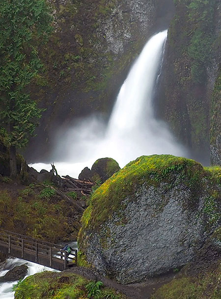
With this unique opportunity in mind, this proposal focuses on a new loop trail along the middle section of Oneonta Canyon, where little known Middle Oneonta Falls has been hidden in plain sight over the century since the first trail was built here. Middle Oneonta Falls is among of the most graceful in the Columbia Gorge, and waterfall enthusiasts have long followed the steep, brushy social path that led to the falls. I made my first trip there in the late 1970s, when I was 16 years old, and returned many times over the years.

Though my photography skills were pretty rough 38 years ago, this is how Middle Oneonta Falls looked way back in 1982. This is also where the falls would first come into view on the proposed Oneonta Loop Trail 

It’s hard to know why the original trail builders passed by Middle Oneonta Falls, and chose to route the main trail high above the falls. The falls can plainly be heard thundering in the forest below, and from one spot on the trail, the brink of the falls can be seen. But for most hikers, Middle Oneonta Falls remained unknown.

This proposal would change that, with a new loop that would not only lead hikers to Middle Oneonta Falls on a well-designed trail, but also take them behindthe falls! More on that, in a moment. Here’s the general location of the proposed loop (shown in yellow) as it relates to the existing Oneonta and Horsetail Creek trails (shown in green):

[click here for a large map]

Why build a new loop trail at Middle Oneonta Falls? One reason is pragmatic: the word is out, and this beautiful waterfall is no longer a secret, as well-worn social paths prove. And, with the forest now burned away, the falls will be plainly visible from the main Oneonta trail, making it impossible to prevent new social paths from forming as curious hikers look for a way to reach the falls.

Given these realities, this concept also focuses on how to make a new loop trail to Middle Oneonta Falls one that provides a new and much-needed destination for casual hikers and families with young kids looking for something less strenuous than what a lot of Gorge hikes require. Loops are the most popular trail option for hikers, too, since they provide a continuous stream of new scenery and adventure.

In the long-term, loops also offer a management tool that is seldom used today, but has great merit in heavily traveled places like the Gorge: one-way trails. On crowded trails in steep terrain, one of the biggest impacts comes from people simply passing other hikers coming from the option direction, gradually breaking down the shoulders of trails over time. One-way trails eliminate this problem, and the provide a better hiking experience with less sense of crowding, too.

With these trail themes in mind, what follows is a tour of the proposed Oneonta Loop Trail, using an exceptional series of aerial photos captured by the State of Oregon in the aftermath of the Eagle Creek Fire. 

The first view (below) captures the existing Oneonta Canyon trail system from Oneonta Falls to Triple Falls, with the proposed new loop trail shown in yellow. The new loop trail would follow the more stable east side of Oneonta Canyon, avoiding the landslide on the west side (which is also shown on the map).

[click here for a large map]

As the above map shows, another benefit of the proposed loop is that it could also serve as a reroute for the existing Oneonta Creek Trail if it becomes impossible to maintain a trail across the landslide, as the new loop would connect to the main trail upstream from the slide.

The next series of maps walk through the proposed loop trail in more detail, starting at the bottom, where the new trail would begin where a social path already extends into the canyon from the lower Oneonta Bridge (below).

[click here for a large map]

From there, the route to Middle Oneonta Falls is surprisingly straightforward (below), and quite short — less than one-half mile. This would make the falls an easy destination for young families and hikers who don’t want to tackle the longer and more strenuous climb to Triple Falls.

[click here for a large map]

Once at Middle Oneonta Falls (below), the new trail would take advantage of the huge cavern behind the falls to avoid building and maintaining another trail bridge, and simply pass behind the falls, instead. 

[click here for a large map]

For hikers coming from the Horsetail Falls trailhead, this would also be the second behind-the-falls experience, having already passed behind Ponytail Falls along the way. This would make the hike to Middle Oneonta Falls a magnet for families with kids, as nothing quite compares with being in a cave behind a waterfall for young hikers!

After passing behind Middle Oneonta Falls, the new loop trail (below) would climb the west slope of Oneonta Canyon just upstream from the slide in a series of four switchbacks, and rejoin the main trail. From there, hikers could continue on to Triple Falls or turn back to the trailhead to complete the new loop.

[click here for a large map]

The next few schematics show how the trail would pass behind beautiful Middle Oneonta Falls. The first view (below) is from slightly downstream, and shows the forested bench opposite the falls where the new trail would descend toward the cave.

[click here for a large schematic]

The next view (below) is from the base of the cliffs at the west side of the falls. The big boulder shown in the previous schematic should help you orient this view, as it is marked in both schematics. This view provides a better look into the cave, which is made up of loose river cobbles and well above the stream level in all but the heaviest runoff. Note my fellow waterfall explorer behind the 90-foot falls (!) for scale. 

[click here for a large schematic]

A third schematic of the falls (below) is from further downstream. This view gives a better sense of the large bench in front of the falls where the approach trail would be located, and how the exit from the cave would navigate a narrow spot between the creek (by the “Big Boulder”) and cliffs on the west side of the falls.

[click here for a large schematic]

As the photos in these schematics show, this is an exceptionally beautiful spot, and though it is now recovering from the fire, it would still make for an easy and popular new destination in the Gorge. Would more visitors make it less pristine? Perhaps, but on my last trips to Middle Oneonta Falls I had to clean up campfire rings built directly adjacent to the creek and carry out beer cans and trash, so it’s also true that legitimizing the trail here would bring “eyes on the forest that would help discourage this sort of thoughtless damage.

Further upstream, there’s also work to do at Triple Falls. This map (below) shows how the main trail could be relocated to follow the existing (and seldom used) spur to the viewpoint and be extended to simply bypass the section of existing trail that drives creation of social trails.

[click here for a large map]

This would provide a long-term solution to the maze of social paths that have formed between the existing trail and the Triple Falls viewpoint. This is a very simple fix, and should be done immediately, while the area is still closed to hikers and the burned over ground and exposed rock make trail construction much easier.

What would it take?

The entirety of Oneonta Canyon is within the Mount Hood National Forest, but administered by the Columbia River Gorge National Scenic Area (CRGNSA) unit of the Forest Service. Despite the creation of the scenic area in 1986 as a celebration of the beauty of the Gorge, there have been no new trails on Forest Service lands in the western Gorge for more than three decades. In fact, the agency has periodically proposed abandoning some of the lightly used backcountry trails in the Mark O. Hatfield Wilderness that have fallen behind in maintenance. 

Oneonta Creek scene before the fire near Triple Falls

The Forest Service is reacting to a long period of strained recreation budgets dating back to the 1990s, but our recent history of disinvestment should not prevent us from looking ahead to the needs of this century. The lack of a future vision is part of what prevents new trails from being designed and built, as there are already plenty of ideas for new trails that could be sustainably built in the western Gorge to help take pressure off the existing system.

The last new trail built in this part of the Columbia River Gorge is the Wahclella Falls loop, completed in 1988. Today, this wonderful loop trail is iconic and among the most beloved in the Gorge. But until the 1980s, a brushy, sketchy user path is how hikers reached Wahclella Falls. Recognizing the need to formalize an official trail, the Forest Service worked with volunteers who completely rebuilt the old trail and added a new leg on the west side of the canyon, creating the well-designed, exceptional loop we know today.

Tiny Maidenhair spleenwort (for scale, the larger fronds at the top of Licorice fern!) are as uncommon as they are beautiful, and are found along the Oneonta Creek Trail near Triple Falls

This proposal for an Oneonta Loop trail would be a great candidate for a similar effort, with Forest Service and volunteer workers creating a new trail that would not only provide a much-needed trail option in the western Gorge, but that would also remedy the social trails that have developed and potentially serve as a new, main route if the landslide on the current trail cannot be stabilized. 

In the aftermath of the Eagle Creek Fire, now is a perfect time to reboot trail building in the Gorge and Oneonta would be the perfect spot to get started. The area is still closed to the public, and trail volunteers have already begin scouting the trail to assess fire damage and make plans for repairs. This scouting work could be expanded to site the new loop trail, and there’s no better way to bring volunteers to trail projects than to build new trails. 

Civilian Conservation Corps (CCC) crews building the cliff-hugging trail above Elowah Falls in 1936

And finally, consider this: almost all of the trails in the Columbia Gorge (and the rest of Mount Hood National Forest) were built over the course of just two decades, in the 1920s and 30s. Amazingly, the system we have today is less than half of what was existed before the industrial logging era began after World War II. And in that period of decline, few new trails were added.

While forest trails were initially built as basic transportation for forest rangers, the Great Depression brought a new focus on recreation and enhancing our public lands through the work of the Civilian Conservation Corps (CCA) and Works Progress Administration (WPA). Our best trails were built during this golden age of trail construction, when trails were designed to thrill hikers with amazing views and adventures. These federal workforce program were put in place under Franklin D. Roosevelt as part of the national recovery plan, when unemployment during the Great Depression exceeded 20 percent, with no end in sight.

Sound familiar? Our normally gridlocked U.S. Congress has just allocated nearly $4 trillion in emergency funding to shore up the country as an unprecedented Coronavirus pandemic takes hold. And congressional leaders are already proposing more stimulus funding in the form of public infrastructure to continue pumping money into the economy and creating work for the jobless. Are we on the brink of another trail-building renaissance in our national forests? Quite possibly — but only if we begin planning for that possibility now.

___________________

And one more thing…

There is a LOT of confusion about place names on Oneonta Creek. USGS topographic maps show only Oneonta Falls and Triple Falls, but Oneonta Falls is shown where Middle Oneonta Falls is located. This is clearly a map error, though one that has endured (and confused) for a very long time. In fact, Oneonta Falls is the tall, narrow falls at the head of Oneonta Gorge and is identified as such in early photos of the Gorge taken long before anyone knew much about the upper canyon.

A case of mistaken waterfall identity at Oneonta…

Meanwhile, there’s a small waterfall right in front of the lower Oneonta footbridge that is often called “Middle Oneonta Falls”, only because it’s in plain sight and so few know that there’s a much larger “Middle Oneonta Falls” just a half-mile upstream. Fortunately, the USGS got Triple Falls right!

So, for the purpose of this article (and in general), I refer to the small falls by the lower footbridge as “Oneonta Bridge Falls”, just to clear things up a bit. Creative, right? Well, neither is “Triple Falls”! Or “Middle Oneonta Falls”, for that matter! But at least we know which waterfalls we’re talking about. Remember, there’s no detail too small for THIS blog!

Thanks again for reading this far, folks!

___________________

Tom Kloster | May 2020

A Second Chance and New Vision for Oneonta?

Oneonta Tunnel traffic jam at the west portal shortly after completion in 1916. The highway had not yet been paved when the tunnel opened.

In the span of just about a decade, the Oneonta Tunnel on the Historic Columbia River Highway (HCRH) has endured a wild ride. The tunnel had been closed since the 1940s when the old highway was rerouted around the cliffs of Oneonta Bluff, and for more than half a century lived only in memories and photographs. 

Then, the tunnel was carefully restored to its original glory in 2006 as part of the ongoing effort to restore and reconnect the HCRH. But within just few years, the beautiful restoration work was badly vandalized by uncontrolled mobs of thoughtless young people unleashed upon Oneonta Gorge by social media (see “Let’s Clear the Logjam at Oneonta Gorge). Then, in September 2017, the restored timber lining was completely burned away during the Eagle Creek Fire.

Today, the tunnel stands empty and fenced-off, waiting to be brought back to life, once again. But does it make sense to restore it as before, only to set this historic gem up for more vandalism? Or could it be restored in a different way, as part of a larger vision for protecting the history and natural beauty of both the tunnel and Oneonta Gorge, while also telling the story of the scenic highway, itself? More on that idea in a moment… 

First, a look at how we got here.

Before the dams and after the railroads…

Looking at Oneonta Tunnel today, it’s hard to understand why the original highway alignment went through Oneonta Bluff to begin with, instead of simply going around it? Why wasn’t it simply built in the current alignment of the historic highway, which curves around the bluff? The answer can be seen in this photo (below) taken before the old highway was built.

Oneonta Bluff before construction of the new highway and tunnel in 1916. The new road was squeezed on the uphill side of the railroad line in many spots in the Gorge, forcing creative solutions from the visionary road designer Samuel Lancaster.

It turns out the original railroad alignment crossed Oneonta Creek on a trestle where the current highway is located today, and was also built snug against the base of Oneonta Bluff. Why was it built this way? Because in the era before Bonneville and Grand Coulee dams were completed in the 1930s (along with the many dams in the Columbia basin that followed), the Columbia River fluctuated wildly during spring runoff. So, the original rail line was built to stand above seasonal flood levels of the time.

When Samuel Lancaster assessed the situation in the 1910s, the only options for his new highway were to move the railroad or tunnel through the bluff. As with other spots in the Gorge where the railroads were an obstacle for the new highway, the second option turned out to be the most expedient, and the Oneonta Tunnel was born. 

This close-up look (below) at previous photo shows a man standing on the railroad trestle crossing Oneonta Creek, pointing to what would soon be the west portal to the new tunnel, and I believe this to be Samuel Lancaster on a survey trip — though that’s just my speculation.

Close-up view of what might be Samuel Lancaster pointing at the future west portal at the Oneonta Tunnel site

When the original alignment of the old highway opened in 1916, the new road paralleled the old railroad grade closely, especially east of the tunnel (below), where a retaining wall and wood guardrail separated the somewhat taller road grade from the railroad.

The east portal of Oneonta Tunnel shortly after completion in 1916

Sometime after the original tunnel was built, possibly in the 1930s, the railroad was moved away from the bluff, perhaps because of falling debris from the Oneonta Bluff landing on the tracks, or maybe just part of modernizing the rail line over time. The flood control provided by dams on the Columbia River beginning in the 1930s (and especially the relatively stable “pool” created behind Bonneville Dam) allowed the railroads to move several sections of their tracks in the Gorge onto extensive rock fill during this period, often well into the river, itself. 

This photo (below) from the 1930s shows the west portal of Oneonta Tunnel after the railroad had been move northward, away from Oneonta Bluff, but before the highway had been realigned to bypass the tunnel.

West approach to the Oneonta Tunnel in the late 1930s after the railroad had been moved away from the bluff, opening the door for the highway, itself, to be routed around the bluff

The tunnel at Oneonta Bluff was one of several along the old highway, though it was easily overshadowed as an attraction by the famous “tunnel with windows” at Mitchell Point, to the east and the spectacular “twin tunnels” near Mosier. What made Oneonta Tunnel famous was the view into impossibly narrow Oneonta Gorge, which suddenly appears as you approach the west portal. 

Oneonta Gorge has been a popular tourist attraction since the old highway opened in 1916. For nearly a century, adventurers have waded up the creek to the graceful 120-foot waterfall that falls into Oneonta Gorge, about a mile from the historic highway bridge. Only in recent years has overcrowding presented a serious threat to both the unique cliff ecosystem and the historic highway features here.

Early visitors to Oneonta Gorge in the 1920s

In the 1930 and 1940s, the Oregon Highway Department began a series of projects in the Gorge aimed at “modernizing” the old highway as the dawn of the 1950s freeway-building loomed. A new river-level route was built to bypass the steep climb the original route takes over Crown Point, with the new route following what is today’s I-84 alignment. 

At Tooth Rock (above Bonneville Dam) a new tunnel was blasted through the cliffs to bypass the intricate viaducts built atop the cliffs by Samuel Lancaster. That tunnel still serves eastbound I-84 today, and has become a historic feature in its own right. And at Oneonta Bluff, a new bridge and tunnel bypass (below) took advantage of the relocated railroad, and was completed in 1948.

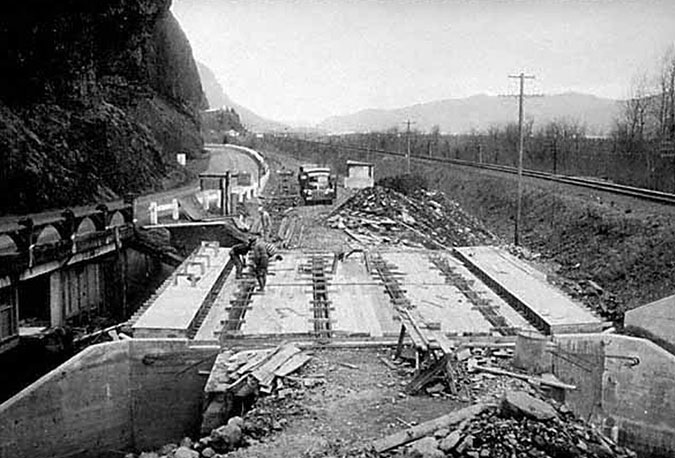
The (then) new highway bypass bridge under construction in 1948; the original bridge is to the left, and still remains today

When the new bridge and realigned highway section opened, the original bridge Samuel Lancaster built at Oneonta Creek was left in place, thankfully, and it survives today as a elegant viewpoint into Oneonta Gorge and gateway to the tunnel. The Oneonta Tunnel was also decommissioned at the time, with fill at both entrances (below). The tunnel remained this way for the next half-century, as a curiosity for history buffs but forgotten by most.

The realigned historic highway after 1948, with the tunnel (on the right) decommissioned with rock fill at both ends

The rebirth of Oneonta Tunnel began with a bold vision for restoring and reconnecting the surviving sections of the Historic Columbia River Highway as part of the landmark 1986 Columbia River National Scenic Area act, with this simple language: 

16 U.S.C. 544j Section 12. Old Columbia River Highway: The Oregon Department of Transportation shall, in consultation with the Secretary and the Commission, the State of Oregon and the counties and cities in which the Old Columbia River Highway is located, prepare a program and undertake efforts to preserve and restore the continuity and historic integrity of the remaining segments of the Old Columbia River Highway for public use as a Historic Road, including recreation trails to connect intact and usable segments.

And so began what will eventually be a four-decade effort to restore the old highway to its original grandeur, with many beautiful new segments designed as if Samuel Lancaster were still here overseeing the project. Work began elsewhere on the old route in the 1980s, but eventually came to the Oneonta Tunnel in 2006 (below). 

Restoration of the Oneonta Tunnel begins in 2006 (ODOT)

The restoration began with simply excavating the old tunnel, and later rebuilding the stone portals at both ends and installing cedar sheathing to line the interior. A new visitor’s parking area was created outside the east portal and the original white, wooden guardrails were also recreated.

Restored interior wood lining nearly complete in the Oneonta Tunnel in 2006 (ODOT)

For the next few years, the restored tunnel stood as a remarkable tribute to the work of Samuel Lancaster and our commitment to preserving the history of the Gorge. It was a popular stop for visitors and also served as fun part of a hiking loop linking the Horsetail and Oneonta trails.

Vandalism & Oneonta Gorge

Every new technology brings unintended consequences, and the advent of social media over the past two decades has been undeniably hard on our public lands. Where visitors once studied printed field guides and maps to plan their adventures, today’s decisions are more often based on a photo posted in some Facebook group or on Instagram, where hundreds will see it as the place to be right now. 

This has resulted in the “Instagram Effect”, where huge surges in visits follow social media posts, both in the immediate near-term for a given place, and in the long-term interest in hiking and the outdoors. According to a 2017 study by Nielsen Scarborough, hiking in the Pacific Northwest has nearly doubled in popularity the past ten years, with Portland and Seattle ranking second and third (in that order) in the nation for number of hiking enthusiasts — Salt Lake City took the top spot. 

Overall, that’s very good news for our society because hiking and spending time outdoors are good for all of us, and we live in a part of the world where we have some of the most spectacular places to be found anywhere in our own backyard. But the immediate effect of social media can often spell bad news when hordes of ill-equipped and ill-informed people descend upon a place that is trending on their phone.

Social media conga-line waiting to enter Oneonta Gorge in 2016 (Photo: John Speth)
Traffic jam at the Oneonta log jam in 2015 (Photo: TJ Thorne)
Traffic jam at the second Oneonta log jam in 2015 (Photo: TJ Thorne)
Cattle call at Oneonta Gorge in 2015 (Photo: TJ Thorne)

Oneonta Gorge is one of the special places that fell victim to the Instagram Effect, with huge crowds of young people overwhelming the canyon on summer days over the past decade. Sadly, the Forest Service did absolutely nothing to curb the invasion, despite the obvious threat to the rare ecosystem here, and hazardous conditions presented by the infamous log-jam that has blocked the entrance to the canyon since the late 1990s (see “Let’s Clear the Logjam at Oneonta Gorge).

And another unfortunate casualty of this unmanaged overcrowding was the Oneonta Tunnel, itself, when the Oneonta Gorge mobs stopped by to record themselves for posterity in the soft, brand-new cedar walls of the restored tunnel (below). While the vandalism was maddening, the lack of any sort of public response from the Forest Service or ODOT to stem the tide was equally frustrating.

The massive defacing of the restored Oneonta Tunnel interior…
…coincided with the explosive, unmanaged crowds that descended…
…upon Oneonta Gorge in the era of social media…

The vandalism didn’t stop with the destruction of the tunnel walls, however. The unmanaged crowds also tagged spots throughout the area with graffiti, and damaged some of the priceless historic features (below) left for us by Samuel Lancaster.

Damage to historic highway features like this staircase came with the disrespectful mobs of young people coming to Oneonta Gorge over the past decade

As discouraging as the damage at Oneonta was, it was also completely predictable. The idea of limiting access to popular spots in the Gorge is one that the public land managers at the state and federal level have been loath to consider, even when overuse is clearly harming the land and our recreation infrastructure. The problem is made worse by the crazy quilt of intertwined state and federal lands in the Gorge, complicating efforts to manage access, even if the will existed.

Then the fire happened in September 2017, changing everything…

The Fire

When the Eagle Creek Fire was ignited on Labor Day weekend in 2017 by a careless firework tossed from a cliff, few imagined that it would ultimately spread to burn a 25-mile swath of the Oregon side of the Gorge, from Shepperd’s Dell on the west to the slopes of Mount Defiance on the east. In the aftermath, the entire burn zone was closed to the public, and much of it still is. While the fire closure put enormous pressure on the few trails that remained open, it also opened the door to rethinking how we access to trails within the burn zone when they are reopened. How and when that happens remains to be seen.

At Oneonta Bluff, the images of the fire were dramatic and unexpected: the inferno spread to the interior of the restored tunnel and lit up the wood lining, completely burning it away like lit fuse. Local news affiliate KPTV published these views (below) taken by fire crews as the tunnel burned.

East portal view of the Oneonta Tunnel burning in September 2017 (KPTV)
West portal view of the Oneonta Tunnel burning in September 2017 (KPTV)

The Oregon Department of Transportation (ODOT) spent the weeks after the fire in 2017 assessing the damage to the historic highway, including these photos of the burned-out tunnel (below).

West portal view of the Oneonta Tunnel after the fire in 2017 (ODOT)
East portal view of the Oneonta Tunnel after the fire in 2017 (ODOT)

Today, the scene at Oneonta Tunnel hasn’t changed that much. ODOT eventually stripped the remaining, charred timbers from the tunnel and fenced off both portals to the public (below), though vandals have since pushed the fencing aside. The area remains closed indefinitely.

Charred reminders of the fire in 2020 at Oneonta Tunnel
East portal approach to the Oneonta Tunnel in 2020
East portal of the Oneonta Tunnel in 2020
Gated east portal of the Oneonta Tunnel in 2020, opened by vandals

Though it might be heresy to admit, my immediate reaction when I saw the images of the burning tunnel in 2017 was relief. There was no end in sight to the social-media driven vandalism, and the interior had pretty much been ruined at that point, so the fire presented an unexpected opportunity for a redo, someday. Quite literally, it’s an opportunity for Oneonta Tunnel to rise from the ashes, but perhaps in a new way this time.

Remembering what we lost

A new vision for restoring Oneonta Tunnel — and protecting Oneonta Gorge — begins with remembering the fine restoration work completed in 2006. What follows is a look back at what that looked like, before social media took its toll.

At the west portal to the tunnel (where the original Oneonta Bridge, with its graceful arched railings, still stands), the restoration included a gateway sign, restored, painted guardrails built in the style of the original highway and an interpretive display near the tunnel entrance (below). The design functioned as a wide, paved trail, with the idea that cyclists touring the historic highway would pull off the main road and ride through the short tunnel section on a path closed to cars.

West portal of the Oneonta Tunnel in 2008, shortly after the renovation

From the original highway bridge over Oneonta Creek, the view extended into Oneonta Gorge, but also down to this fanciful stairway (below) right out of a Tolkien novel. This feature of the original historic highway continues to take visitors down to the banks of Oneonta Creek (the landing Newell in the bottom center of the photo, at the base of the stairs, is the one broken by vandals in an earlier photo). Just out of view at the top of the stairs is a picturesque bench built into the mossy cliff.

Historic Oneonta Stairwell in 2008

The west portal restoration included new stonework around the timber frame that closely matched the original design (below). 

West portal of the restored Oneonta Tunnel in 2008

Inside, the restored tunnel was lined with cedar plank walls and ceiling, supported by arched beams (below).

Wood interior of the restored Oneonta Tunnel in 2008

The east portal was similar to the west end of the tunnel, with stone masonry trim supporting the portal timbers (below).

East portal of the restored Oneonta Tunnel in 2008

Like the west side, the east entrance approach (below) was designed for cyclists to leave the highway and tour the tunnel and historic bridge before returning to the main road. 

East portal approach to the Oneonta Tunnel in 2008

In practice, most of the traffic in the tunnel before the fire came from hikers and curious visitors parking on the east and west sides and walking the path to the viewpoint into Oneonta Gorge. This is partly because bicycle touring in the Gorge focuses on the extensive car-free-sections of the historic highway, though the shared-road portions of the old highway are expected to see continued growth in cycling as the entirety of the old route is fully restored.

A Fresh Start (and Vision)

Oneonta Gorge in about 1900, more than a decade before the first automobiles would travel through the Columbia River Gorge

The 2006 restoration of Oneonta Tunnel and its approaches was based on the idea of it simply serving as a bicycle and pedestrian path as part of the larger historic highway restoration project. But the tragic defacing of the newly restored tunnel is a painful reminder that it’s simply not safe to assume it will be respected if left open to the public, unprotected, as it was before. Even gates are not enough, as vandals have since demonstrated by tearing open the temporary fencing on the burned-out tunnel.

But what if we considered the tunnel and its paved approaches, including the historic highway bridge, as a useful space instead of a path? The tunnel is surprisingly wide, at 20 feet, and 125 feet long. That’s 2,500 feet of interior space! What if the tunnel were restored this time with the idea of using this as interior space? As a history museum, in fact? With the paved approaches as plazas with outdoor seating, tables and bike parking?

Though it’s not a perfect comparison, there is an excellent model to look to in southern Utah, just east of the town of Kanab, where the privately operated Moqui Cave Natural History Museum is built inside a sandstone cave. The cave was once a speakeasy, then a dance hall in the 1930s, before it was finally converted to become a museum in the 1040s.

Moqui Cave Museum near Kanab, Utah (Wikipedia)

While passing through Kanab on a recent road trip, the stonework blending with the standstone cave entrance at Moqui Cave (below) reminded me of the restored stonework at Oneonta tunnel portals, and how the entrances to the tunnel might be enclosed to create a museum space at Oneonta.

Moqui Cave Museum entrance (TripAdvisor)

Like our Oneonta Tunnel, Moqai Cave is mostly linear in shape (below), with displays of ancient Puebloan artifacts and fossil dinosaur tracks displayed along its sandstone walls.

Moqui Cave Museum interior (TripAdvisor)

These section of the Moqui Cave are roughly the same width and height of the Oneonta Tunnel, with plenty of room for both displays and walking space.

Other solutions for enclosing the entrance at Oneonta Tunnel could draw from our own Timberline Lodge, on Mount Hood. While the stone foundation for the lodge is man-made, it’s not unlike the basalt portals at Oneonta. This is the familiar main entrance on the south side of the lodge (below), showing how the massive wood entry doors are built into the arched stone lodge foundation.

Historic Timberline Lodge entrance door (Wikipedia)

About ten years ago, another entrance to Timberline Lodge was handsomely renovated (below) to become barrier-free, yet still the massive, rugged lodge style that was pioneered here. This updated design shows how modern accessibility requirements could be met at an enclosed Oneonta Tunnel.

Restored Timberline Lodge side entry door (Versatile Wood Products)

There are other examples for enclosing Oneonta Tunnel as a museum space, too. While it would be a departure from Samuel Lancaster original purpose and design to enclose the tunnel, I suspect he would approve, given how the Gorge has changed in the century since he built the original highway.

There are logistics questions, of course. Is the Oneonta Tunnel weatherproof? If the dry floors during winter the months after the 2006 renovation are any indication, than yes, having 150 feet of solid basalt above you provides good weather proofing! Does the tunnel have power? Not yet, but a power source is just across the highway along the railroad corridor. These are among the questions that would have to be answered before the tunnel could be used as a museum, but the potential is promising!

Getting a handle on parking…

One of the most vexing problems along the busy westerly section of the Historic Columbia River Highway is how to manage parking as a means for managing overall crowding. Today, parking is largely unmanaged in this part of the Gorge, which might sound great if you believe there is such a thing as “free parking” (there isn’t). But in practice, it has the opposite effect, with epic traffic jams on weekends and holidays, and travelers waiting wearily for their “free” spot at one of the waterfall pullouts.

Weekend traffic jams on the historic highway are the norm today, and result from unmanaged parking (KATU)

At Oneonta, the lack of managed parking is at the heart of the destruction that mobs descending on Oneonta Gorge brought to the area, including the defacing of the tunnel. Some simple, proven parking management steps are essential, no matter what comes next at Oneonta. First, parking spaces must be marked, with a limited number of spots available and enforced. Can’t find a spot? Come back later, or better yet, at a less crowded time. 

Second, the parking should be managed with time limits (30 minutes, 60 minutes and a some 120 minute spots for Oneonta Gorge explorers). Timed parking also allows for eventual parking fees during peak periods, which in turn, could help pay for badly-needed law enforcement in the Gorge. Eventually, it makes sense to meter all parking spots in the Gorge, but that’s going to take some a level of cooperation between ODOT, the Forest Service and Oregon State Parks that we haven’t seen before, so lots of work lies ahead on that front.

So, these are all basic tools of the trade for managing parking in urban areas, and the traffic in the Gorge is well beyond urban levels. It’s time to begin managing it with that reality in mind.

The east parking area (below) at the Oneonta Tunnel was rebuilt as part of the tunnel restoration in 2006, but is poorly designed, with a huge area dedicated to parallel parking. 

Unmarked, poorly designed shoulder parking at the new pullout east of the Oneonta Tunnel comes complete with a sidewalk, and could be easily be restriped and better managed with angled spaces

However, this relatively new parking area includes a (rarely used) sidewalk, and thus it could be striped with angled spaces that would make for more efficient parking and also include space for a tour bus pullout. ODOT would just need to take a deep breath, since this would involve visitors backing into the travel lane when exiting a spot — a bugaboo for old-school highway engineers. But drivers manage this all time in the city. We can handle it.

The west parking area (below) at Oneonta is an unfortunate free-for all, with an unmanaged shoulder that was ground zero for the huge social media crowds that began clogging Oneonta Gorge in the late 2000s. This area needs a limited number of marked, timed parking spots no matter what happens at Oneonta in the future. There’s also plenty of room for a sidewalk or marked path in front of the parking spaces, along the foot of the cliffs, similar to the new sidewalk built east of the tunnel. This would make for much safer circulation of pedestrians here.

The west parking area would also be the best place for accessible parking spaces, since it offers the shortest, easiest access to the tunnel and views of Oneonta Gorge from the historic bridge.

Looking west for inspiration… and operations?

Most who visit the iconic Vista House at Crown Point don’t know that the interpretive museum inside the building is operated as a partnership between the non-profit Friends of Vista House and Oregon State Parks.

Vista House rotunda (TripAdvisor)

The Friends formed in 1982, well before the Columbia River Gorge Scenic Area was created in 1986, and have done a remarkable job bringing the Vista House back from a serious backlog of needed repairs. Today, it is among the jewels that draw visitors to the Gorge.

Vista House interpretive displays and gift shop (TripAdvisor)

In their partnership with State Parks, the Friends operate a museum inside Vista House, as well as a gift shop and espresso bar in the lower level. Proceeds from the gift shop are directed to their ongoing efforts to preserve and interpret this structure for future generations.

Vista House interpretive displays (TripAdvisor)

The unique partnership between the Friends of Vista House and Oregon State Parks is a proven, successful model, and it could be a foundation for a museum in the restored Oneonta Tunnel. Could the Friends operate a similar facility at Oneonta as part of an expanded mission? Perhaps. Or perhaps another non-profit could be formed as a steward for the tunnel, in partnership with the U.S. Forest Service and State Parks? 

Crucially, having a staffed presence at Oneonta would allow for effectively managing access to Oneonta Gorge, itself, using a timed entry permit system. This is a proven approach to protecting vulnerable natural areas from overuse, and the Forest Service already uses timed permits elsewhere. Ideally, this permitting function would be funded by the Forest Service, and would include interpretive services for other visitors discovering the area, as well.

Focus on Sam Lancaster’s Road?

Samuel Lancaster, the dreamer behind the Columbia River Highway

On the cut stone wall of the Vista House, a bronze plaque honoring Samuel Lancaster provides a very brief introduction to the man. Displays inside Vista House, and elsewhere in the Gorge, also tell his story in shorthand. But Lancaster’s original vision and continued legacy in shaping how we experience the Gorge deserves a more prominent place. A converted Oneonta Tunnel Museum would be a perfect place to tell that story.

The walls of the tunnel provide a combined 250 feet of display space, which could allow visitors to have a detailed look at some of the secrets of Sam Lancaster’s amazing road. The State of Oregon has a rich archive of historical photos of the highway during its construction phase, mostly unseen by the public for lack of a venue. 

These include rare photos of spectacular structures now lost to time. Among these (below) is the soaring bridge at McCord Creek, destroyed to make room for the modern freeway, and the beautiful arched bridge at Hood River, replaced with a modern concrete slab in the 1980s.

The soaring, former McCord Creek Bridge under construction in 1915 (ODOT)
The graceful former Hood River Bridge in the 1920s, replaced with a freeway-style concrete slab in the 1980s (ODOT)

A new Oneonta Tunnel Museum could tell the story of Sam Lancaster’s inspiration for the famous windowed tunnel at Mitchell Point (below), another lost treasure along the old highway destroyed by modern freeway construction.

The former Mitchel Point Tunnel of many windows (ODOT)

A new museum at Oneonta could also tell the story of the surviving gems along the old road that are now part of the Historic Columbia River Highway State Trail. These include (below) the spectacular section between Hood River and Mosier, with its iconic twin tunnels, the beautifully crafted stone bridge at Eagle Creek and the graceful arched bridge at Shepperd’s Dell.

1920s scene along the spectacular Mosier Twin Tunnels section of the old highway
Eagle Creek Bridge construction in 1915 (note the group of stonemasons in the viewing alcove on the left)
Shepperd’s Dell Bridge on dedication day in 1916. Samuel Lancaster is riding in backseat of  the first automobile (photo trivia: the big Douglas fir at the far left in this image is still standing and survived the 2017 Eagle Creek fire with some scorching to its massive trunk!)

The story behind the building of the old highway extends beyond the genius of Samual Lancaster and the beauty of the design. The construction, itself, was a monumental undertaking, and the stories of the people who built this road deserve to be told in a lasting way for future generations.

The Lancaster story continues today, as well. Since the 1980s, ODOT, Oregon State Parks and scores of dedicated volunteers have steered the ongoing effort to restore and reconnect the old route, as called for when the Columbia River Gorge National Scenic Area Actwas signed into law in 1986.

Many of the restoration projects are epic achievements in their own right, and deserve to have their story told for future generations to appreciate. All are inspired in some way by Samuel Lancaster’s original vision for a road blended seamlessly into the Gorge landscape in way that allows visitors to fully immerse themselves in the scenery. These include handsome new bridges (below) at Warren Creek and McCord Creek, as well as a planned recreation of the Mitchell Pont Tunnel.

The new bridge over Warren Creek on the restored Columbia River Highway State Trail
The new bridge over McCord Creek on the restored Columbia River Highway State Trail

What would it take to create an Oneonta Tunnel Museum dedicated to Samuel Lancaster’s enduring vision? Capital funding, of course, but that will surely come at some point, given the current state of the tunnel after the fire. It would also take a willing non-profit partner and a strong interest from the Forest Service, ODOT and Oregon State Parks to try something different when it comes time to once again restore the tunnel. But the time to start that conversation is now, before the agencies start down the path of simply repeating mistakes from the past decade.

So, for now, this is just an idea. But in the meantime, if you’d like to learn more about Samuel Lancaster and his amazing highway, there are two books that should be in every Gorge-lover’s library. And they make for especially good reading in this time in which we’re not able to visit the Gorge! 

The first is Samuel Lancaster’s own book, The Columbia: America’s Great Highway, first published in 1916 by Lancaster, himself. This book is as eccentric and sweeping as Lancaster’s own imagination, and his love for the Gorge comes through in his detailed descriptions of the natural and human history. It’s easy to see how his vision for “designing with nature” grew from his intense interest in the natural landscape of the Gorge.

Lancaster’s original book was reproduced in 2004 by Schiffer as a modern edition, and is still in print. The modern version includes restored, full-color plates from the 1916 edition, as well as additional plates that were added to a 1926 version by Sam Lancaster.

Essential reading for any Gorge lover!

A wonderful bookend to Sam Lancaster’s classic is Building the Columbia River Highway: They Said it Couldn’t Be Done by Oregon author Peg Willis. This exceptional book focuses on the highway, itself, and the collection of characters who came together to make Samuel Lancaster’s bold vision become reality.

Peg’s book also includes a terrific selection of seldom-seen historic photos of the highway during it’s original construction, reproduced with fine quality. In fact, the stories and images in this book would a perfect blueprint for the future Oneonta Tunnel Museum… someday!

_________________

As always, thanks for stopping by and reading through yet another long-form article in our era of tweets and soundbites!

Special thanks to Oregon photographer TJ Thorne, who contributed photos of the Oneonta Gorge summer crowds for this article. Those were just a few snapshots from his iPhone, but please visit TJ’s website to see his amazing fine art nature photography from landscapes across the American West, and please consider supporting his work.

Oregon’s outdoor photographers serve as our eyes on the forest, taking us places we might otherwise never see. They help the rest of us better appreciate and protect our public lands through their dedicated work, but they need our support to continue their work. 

Thanks, TJ!

_________________

Tom Kloster • April 2020

Fire in WyEast Country

01MirrorLakeHood1920s

Scorched Mirror Lake just beginning to recover from the Sherar Burn in early 1900s

Oh, if only our lives spanned 800 years instead of 80! No doubt we would see (and zealously protect) our world differently with the benefit of that long perspective. And it turns out that Bowhead whales, Greenland sharks and even pond Koi can live well beyond two centuries. Heck, the lowly Icelandic clam can live up to 500 years! The advantage these creatures have over humanity is the ability to see the cycles of life as a perpetual rhythm, not simply discrete events.

Which brings us to the deep sadness that so many of us are experiencing with Eagle Creek Fire of 2017 in the Columbia River Gorge. To so many of us, losing the lush green forests that framed the waterfalls and cliff-top vistas in the Gorge is like losing an old friend.

Yet, with a bit more longevity, we’d be able to see the cycles of fire and recovery repeat in succession, and we could even look forward to walking again among 200 year old forest giants along today’s scorched trails in the Gorge. Oh, to be an Icelandic clam…

02YocumFallsTomDickMountain1936

Yocum Falls and Tom Dick and Harry Mountain as they appeared after the Sherar Burn in the early 1900s

[click here for a larger view]

For many of us, the Eagle Creek Fire of 2017 feels like a redux of 2008 and 2011, when the Gnarl Ridge and Dollar Lake fires burned off forests on the east and north sides of Mount Hood, respectively. Just as fire crews worked this month to protect Multnomah Falls Lodge and the Vista House at Crown Point from fire in the Gorge, crews in 2008 and 2011 scrambled to protect iconic Cloud Cap Inn, the nearby Snowshoe Lodge and the many historic CCC structures at Tilly Jane from the fires.

For those of a certain age, the hike to Mirror Lake on Mount Hood once involved walking beneath hundreds of bleached snags reaching to the sky. These were the remnants of the Sherar Burn that scorched the entirety of Tom Dick and Harry Mountain, along with the upper Still Creek valley and points south in the early 1900s. The visible traces of this fire lasted prominently well into the 1980s, though the forest has largely recovered today.

03PunchbowlFalls1920s

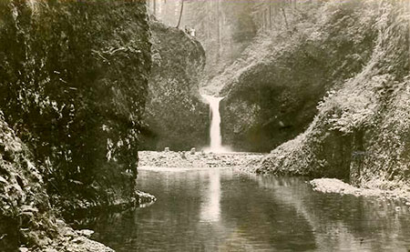
The prominent gravel bar at the base of Punch Bowl Falls on Eagle Creek in the early 1900s resulted from erosion from a nineteenth century fire.

The Eagle Creek Fire of 2017 in the Columbia Gorge will also follow this timeless sequence of destruction and renewal. There’s also some comfort to be gained from knowing that we’ve had a steady stream of fires in the Gorge, even in the very short timeframe of white settlement:

1902 – Yacolt Fire (238,000 acres)

1910 – Carson Fire (2,716 acres)

1917 – Stevenson Fire (7,606 acres)

1927 – Rock Creek Fire (52,500 acres)

1929 – Dole Valley Fire (202,500 acres)

1936 – Born Fire (7,897 acres)

1949 – Beacon Rock Fire (3,658 acres)

1952 – Skamania Fire (1,057 acres)

1991 – Wauna Point (375 acres)

1991 – Multnomah Falls Fire (1,200 acres)

1997 – Eagle Creek Fire (7 acres)

2000 – Oneonta Fire (5 acres)

2003 – Herman Creek Fire (375 acres)

2017 – Eagle Creek Fire (33,000+ acres)

The Forest Service reports that nearly all of the reported Gorge fires in recent decades (98%) have been human caused, but that certainly doesn’t mean the Gorge wouldn’t have burned without human behavior. The Forest Service describes the uniquely explosive fire conditions in the Gorge as follows:

“From early September through mid-October the west end of the gorge offers the best of all worlds from a fire’s perspective. The tremendous fuel loading of a west side forest coupled with hot and dry wind and incredibly steep terrain make for some of the most spectacular burning conditions the Pacific Northwest has to offer.”

Early white settlers to the Gorge called this “the Devil Wind” after the inferno that was the Yacolt Fire burned a quarter million acres on the north side of the river in less than 36 hours.

1991 Gorge Fires

04WaunaFire1991

Wauna Fire burning above Eagle Creek in 1991

Few remember it today, but in 1991 a pair of fires burned a sizeable stretch of the Oregon side of the Columbia River Gorge. The Multnomah Falls fire was a spectacular event, burning 1,200 acres along the Gorge wall from Multnomah Falls to Angels Rest, and nearly burning the historic Multnomah Falls Lodge. Sound familiar?

05MultnomahFallsFire1991

Multnomah Falls fire in 1991

The Multnomah Falls burn of 1991 has recovered quickly, and few hikers realize that the young forests along the popular Angels Rest trail were the direct result of the burn, though bleached snags still stand to tell the story. Visitors to Multnomah Falls still walk along the jumbo-size debris nets installed below the Benson Bridge to catch debris from the burned slopes of the 1991 fire, above. A major casualty of the 1991 fire was the beloved Perdition Trail that once connected Multnomah Falls to Wahkeena Falls on a route etched into the Gorge cliffs.

In 1991, the smaller Wauna Fire also burned 375 acres on the slopes directly above the west bank of Eagle Creek, below Wauna Point. This area has also largely recovered in the years since.

Early Fires in the Gorge

06TripleFallsOneonta1890s

This unusual photo of Triple Falls from the 1890s shows snags from an earlier fire in Oneonta canyon in the background.

Early photos show that fire has been a routine part of the Columbia River Gorge ecology. That pattern changed with fire suppression efforts in the 20th century, which in turn, set the conditions for the catastrophic Eagle Creek Fire of 2017. Photos from Oneonta canyon (above) in the 1890s show slopes covered in bleached snags, suggesting a major fire sometime in the 1800s.

07ShellrockMountain1950s

Shellrock Mountain’s east and south slopes were still recovering from fire in this 1940s view from the old Columbia River Highway.

Further east, places like the east slopes of Shellrock Mountain (above) were much less forested than today, thanks to repeated fires in the Gorge.

08BridgeOfGodsWaunekaPoint1930s

Snow covers the burned east slopes of Wauneka Point, the ridge that divides McCord and Moffett Creeks, in this 1930s view from Bridge of the Gods. This ridge burned again in the 2017 Eagle Creek Fire.

[click here for a larger view]

The above photo of the (then) new Bridge of the Gods in the early 1930s also shows large open slopes on Wauneka Point in the background, marked by winter snow. These slopes had largely reforested in subsequent years, but burned again in the Eagle Creek Fire of 2017, repeating a timeless cycle.

09BonnevilleAldrichHamilton1936

Burned over Aldrich Mountain and Hamilton Mountain in 1936.

[click here for a larger view]

Construction-era photos of Bonneville Dam in the late 1930s also provide detail on the state of the forests in Gorge at that time. The view north (above) shows burned-over Aldrich and Hamilton Mountains, both completely burned in the catastrophic Yacolt Burn.

10BonnevilleConstruction1935

Burned over Ruckel Ridge and Benson Plateau in 1937.

[click here for a larger view]

Looking to the southwest from the dam site, Ruckel Ridge and Benson Plateau (above) were also largely burned over in the late 1930s. These areas burned again in the Eagle Creek Fire of 2017.

1931-34 Lookout Survey: A History of Fires

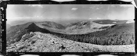
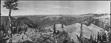
Given that we’re stuck with relatively short stints on this planet, we humans do have the unique ability to record history for the benefit of our descendants. And it turns out that in the 1930s and early 1940s, early forest rangers in WyEast country did just that with a series of lookout tower panoramas.

This rich photographic resource was mostly forgotten until just a few years ago, when caches of these images archived in university photo collections were scanned and uploaded to the web in high resolution. They provide an astonishing, invaluable amount of detail, most from the years 1930-36.

Ironically, these panoramic images were captured as part of the massive U.S. Forest Service effort to prevent fires, with each set providing a 360-degree survey from the hundreds of lookout sites that were developed on public lands across the country.

In the Pacific Northwest, the panoramic photos provide an excellent glimpse into the way our forests had evolved for millennia, and before fire suppression took hold. The following are a few clips from this archive for places through the Mount Hood country and in the Columbia River Gorge.

Basin Point (1933)

11BasinPointNorth1933

Mount Hood from obscure Basin Point, now overgrown with trees.

[click here for a larger view]

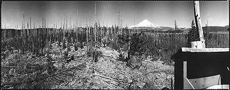
Basin Point is largely forgotten today, but at one time this high spot north of today’s Timothy Lake provided a lookout location for the upper Oak Grove Fork basin. This lookout site probably wouldn’t have been used had it not been for a fire that had fairly recently swept over the butte, burning away a young forest that was still getting established here. The view is from the south edge of the Sherar Burn, a fire that swept across a large area south of Government Camp sometime in the late 1800s or early 1900s.

Buck Peak (1933)

12BuckPeakNorth1933

This view is from Buck Peak toward the burned-over Eagle Creek and Tanner Creek Valleys.

[click here for a larger view]

Today, Buck Peak is known for its sweeping views of Mount Hood and Lost Lake, but view (above) to the north from the former lookout site also shows the burned over Eagle Creek and Tanner Creek Valleys, with burned Tanner Butte as the prominent peak left of center. The upper slopes of the mostly unburned Lake Branch valley, to the right, also show signs of fire.

Bull of the Woods (1934)

13BullofWoodsEast1934

The view looking southeast to Mount Jefferson from Bull of the Woods lookout shows a healthy mosaic of recent burns and recovering forest in the 1930s.

[click here for a larger view]

Fires have returned in recent years to Bull of the Woods, thanks in part to its wilderness protection that puts the land off-limits to timber harvesting (and thus “okay to burn” from a fire suppression perspective). This view looking toward Mount Jefferson shows a mosaic of recent burns and recovering forest, a healthy pattern that is returning with new fires in recent years.

Chinidere Mountain – North (1934)

14ChinidereNorth1934

This view looking north from Chinidere Mountain into the Herman Creek valley shows much of the drainage burned in the 1930s.

[click here for a larger view]

Today, the view to the north from popular Chinidere Mountain is gradually being obscured by recovering forests. This 1934 view shows the large burn that extended across the Herman Creek drainage at the time, from Benson Plateau (left of center) over Tomlike Mountain (right of center) toward Green Point Mountain (left edge of this photo). Though the forest here had almost completely recovered, much of the area in this view was burned again in the Eagle Creek fire of 2017.

Chinidere Mountain – West (1934)

15ChinidereWest1934

This view west from Chinidere Mountain shows recovering forests in the Eagle Creek drainage.

[click here for a larger view]

This view looking west from Chinidere Mountain into the Eagle Creek drainage shows a recovering forest in the upper valley and on the adjacent slopes of Indian Mountain (to the left) and Tanner Butte (right of center).

This area was at the heart of the Eagle Creek and Indian fires in 2017, and much of the area shown in this view burned.

Devils Peak (1933)

16DevilsPeakNorth1933

This 1930s view from Devils Peak shows an extensive burn on Zigzag Mountain and lower slopes of Devils Peak.

[click here for a larger view]

The old lookout tower still survives on Devils Peak, located within the Salmon-Huckleberry Wilderness, but the view of Mount Hood has nearly disappeared behind the recovering forest. This 1930s view shows the extensive burn that encompassed the long ridge of Zigzag Mountain (center, in the distance) and lower slopes of Devils peak, in the foreground. Both areas have since mostly reforested in the era of fire suppression.

The west end of Tom Dick and Harry Mountain is the burned-over ridge extending below Mount Hood in this photo, part of the late 1800s Sherar Burn. The burned lower slopes of Devils Peak and upper Still Creek valley were also burned in this historic fire.

Green Point Mountain (1934)

17GreenPointWest1934

This view from Green Point Mountain shows an extensive pattern of fires in the upper Herman Creek Valley.

[click here for a larger view]

In this view from Green Point Mountain, evidence of a mosaic burn stands out, with completely burned forest near the summit and surviving forest just below. The heavily burned slopes of Tomlike Mountain (center) and Chinidere Mountain (left of center) are in the distance are part of a wide mosaic of burns in the upper Herman Creek valley.

Old growth trees along Herman Creek today are proof that even large fires here didn’t completely burn the drainage. The Eagle Creek fire of 2017 burned a significant part of the Herman Creek drainage, and it is unknown how the old growth stands fared in the face of this recent fire.

High Rock (1933)

18HighRockNorth1933

The Abbott Burn encompassed the area surrounding High Rock, including the upper Roaring River drainage.

[click here for a larger view]

The view from High Rock looking north to Mount Hood was once surrounded by the extensive Abbott Burn, which engulfed much of the Roaring River watershed and part of the Salmon River backcountry sometime in the 1800s or early 20th century.

In the 1930s, a Civilian Conservation Corps (CCC) camp was established on the shoulder of High Rock, and a small army of CCC workers planted thousands of trees across the Abbott Burn. Many survived, and much of the reforestation in the Roaring River valley resulted from this forest intervention effort. But the rocky high country of Signal Buttes and other nearby ridges are still largely open and covered in fields of huckleberries, with the forest recovery advancing much more slowly.

This pattern of open, regularly burned peaks and ridge alternating with lush canyon floors is the natural state of our forests. Lightning-caused fires regularly burn away forests surviving on the thin, dry soils found higher slopes and ridges, and larger trees in moist soils on lower slopes and canyon bottoms are better able to survive natural fires.

Lost Lake Butte (1933)

19LostLakeButteWest1933

The burned upper slopes of Lost Lake Butte as they appeared in the 1930s, with Lost Lake in shimmering the distance.

[click here for a larger view]

Though the old-growth giants on the shores of Lost Lake have dodged or resisted fire for centuries, the forests on the dry, upper slopes of Lost Lake Butte were burned sometime in the late 1800s in a classic mosaic pattern that can be seen in the 1930s panoramic photos.

In the photo above, strips of larger, surviving trees can be seen within the burn, and a distinct line between the young,recovering forest in the burn area and larger trees that survived the fire is clearly visible along the near shore of Lost Lake. Raker Point (featured in the next photo) is visible as the open spur at the far right edge of the Lost Lake Butte panorama.

Raker Point (1933)

20RakerPointWest1933

Hundreds of snags along the crest of Sawtooth Ridge and Raker Point (in the distance) show the extent of fire on the north side of Lost Lake, sometime in the late 1800s or early 1900s.

[click here for a larger view]

Raker Point is a little known peak located just north of Lost Lake, on the west end of Sawtooth Ridge (Raker Point is the distant open spur right of center in this photo). The ridge and Raker Point were burned sometime in the late 1800s or early 1900s, possibly in the same fire that scorched Lost Lake Butte. The recovery on Raker Point was well under way in the 1930s photos, with 10-20 year old seedlings rising up among the hundreds of bleached snags left from the fire.

Lost Lake was one of the earliest recreation destinations in WyEast country, with hardy visitors from the Hood River Valley making their way to campsites along the lake shore as early as the 1890s. In the 1920s, a “modern” dirt road was finally completed to Lost Lake, roughly along the same route as today’s paved highway.

Signal Buttes (1933)

21SignalButtesNorth1933

Located west of High Rock, the Signal Buttes were completely burned in the Abbott fire of the early 1900s, and are still recovering today.

[click here for a larger view]

Today, the Signal Buttes are at the heart of the Roaring River Wilderness, and as described above, are still slowly recovering from the Abbott Burn fire that swept the area, despite efforts by the CCC in the 1930s to replant the forest here. The patch of unburned forest on the floor of the Roaring River valley (in the low area of the photo, below Mount Hood) are old growth Douglas fir and Western red cedar that survived the Abbot Burn — and likely many fires before that, as trees more than 1,000 years old are found here.

It’s also likely that the Signal Buttes will continue to be an open expanse of Beargrass meadows and Huckleberry fields if fires are allowed to burn here, once again. In this way, the Roaring River Wilderness is well on its way to a more natural condition of open ridges and a mosaic of old and recovering forests on the canyon floor and walls. Because the area was permanently protected as wilderness in 2009, future generations will have an opportunity to watch the forest here continue to evolve with fire, once again.

The rugged ridges and peaks just beyond Signal Buttes in this panorama are the high country of today’s Salmon-Huckleberry Wilderness. In contrast to the Signal Buttes, this northern extent of the Abbott Burn has largely recovered, with just a few peaks and ridgetops remaining as open Beargrass and Huckleberry fields.

Tumala Mountain (1933)

22SquawMtnEast1933

This view looking east from Tumala Mountain shows the burned ridges of the Salmon River and Roaring River high country in the 1930s. Mount Hood is on the extreme left.

[click here for a larger view]

This remarkable panorama from Tumala Mountain shows a burned-over landscape in much of what are today’s Salmon-Huckleberry (areas to the left) and Roaring River (areas to the right) wilderness areas. Most of this landscape is now heavily forested, with the exception of a few ridge tops and the crest of the Signal Buttes, described earlier and visible as the completely burned ridges in the upper right of this photo.

This photo also shows a healthy mosaic burn pattern on the nearby mountains immediate slopes, with bands of trees surviving between burned strips. This more natural fire pattern creates a rich habitat that, in combination with the series of lakes in the glacial valley at the foot of the peak, makes for an ideal landscape for wildlife.

You may notice that the photo markings on the left identify this as “Squaw Mountain”. In 2007, the Oregon Geographic Names Board renamed this peak out of respect for indigenous peoples, as the term “squaw” is considered derogatory. This change is part of a larger effort to rename other landmarks using “squaw” across the state. The word Tumala means “tomorrow” or “afterlife” in Chinook jargon, and is an apt name for this idyllic spot in WyEast country.

Summit Meadows (1930)

23SummitMeadowsNorth1930

This 1930 view of Summit Meadows shows signs of an extensive fire along the south slopes of Mount Hood in the vicinity of Government Camp.

[click here for a larger view]

Early photos of Government Camp and Summit Meadows on Mount Hood’s south side show thousands of bleached snags marking a fairly recent fire in the area. These could mark a series of discrete fires or could be related to the larger Sherar Burn or the fires that swept Zigzag Mountain in roughly the late 1800s.

23aGovernmentCamp1915

Extensive burns on Mount Hood above Government Camp in 1915 (Courtesy: History Museum of Hood River County)

The extent of the historic fires on Mount Hood’s south side is especially interesting given the degree of resort development here in the century since fire suppression began. The volcanic soils on Mount Hood’s south shoulder are among the youngest on the mountain, as much of the area was buried in fresh volcanic debris from eruptions that occurred in the late 1700s.

This makes the forests here especially vulnerable to fire because of the poorly developed soils, southern exposure and late summer stress from seasonal drought. Yet, the degree of development on this side of Mount Hood also makes it unlikely that forest fires will ever be allowed to burn naturally. Instead, these forests are good candidates for prescribed, controlled burns that could restore the forests to a more natural state while also protecting the hundreds of structures located here.

Tanner Butte (1930)

24TannerButteWest1930

This 1930 view from massive Tanner Butte looks west through charred forests toward Tanner Creek canyon, the Bull Run Watershed (on the left) and Larch Mountain (on the right horizon).

[click here for a larger view]

Tanner Butte and its long northern ridge is a prominent landmark in the backcountry of the Columbia River Gorge, dividing the Eagle Creek and Tanner Creek drainages. The panoramic photos from 1930 show a heavily burned landscape in this area, and longtime hikers can still remember when the ridges around Tanner Butte were still covered with open meadows, as recently as the 1970s.

More recently, the forests had recovered across almost all of the burned areas shown in this panorama, but the Eagle Creek Fire of 2017 appears to have hit the Tanner Creek basin especially hard. This could be a result of the relatively young, even-aged forest here, but fire suppression almost certainly played a role in this fire becoming catastrophic.

Much of the area visible here is within the Mark O. Hatfield Wilderness, and will provide yet another laboratory for future generations to watch and learn from as the forest recovers.

Wildcat Mountain (1933)

25WildcatMtnNorth1933

The view from Wildcat Mountain toward McIntyre Ridge and Portland in the far distance.

[click here for a larger view]

Wildcat Mountain lies at the western edge of the Salmon-Huckleberry Wilderness, and Portland’s downtown high-rises are visible from its summit. Or, at least they were a couple of decades ago, before the recovering forests here enveloped the summit with a stand of Noble fir and Mountain hemlock.

Broad McIntyre Ridge (pictured in the distance in this photo) still has a few open Beargrass meadows with sweeping views of Mount Hood, but even here the forest is advancing rapidly.

The 1930s panoramic view shows a completely different landscape, with mixed stands of forests in the valleys below the Wildcat Mountain and its ridges that suggest a long history of mosaic burns. Without fire suppression, McIntyre Ridge and Wildcat Mountain would likely have burned again since the 1930s.

Since 1984, this area has been protected as wilderness, so future fires will likely be allowed to burn. If the recent Eagle Creek fire in the Gorge is any indication, the young forests that have grown since this panorama was taken are likely to be the first to burn, as we saw in the Tanner Creek and Eagle Creek areas.

Wolf Camp Butte (1933)

26WolfCampButteEast

This view doesn’t exist anymore, thanks to a completely recovered forest on Wolf Camp Butte.

[click here for a larger view]

Wolf Camp Butte is another lookout site made obscure by the recovering forest that has completely covered the summit. More of a high spot than a peak, this 1933 view from the former lookout site provides us with an excellent look at the extent of the Sherar Burn. The canyon in on the right holds the Salmon River, descending from the Palmer Glacier on Mount Hood (just out of view to the left).

This fire burned north to present-day Government Camp and south to at least the Salmon River, encompassing a very large area. Parts of the Sherar Burn may have been replanted by the CCC in the 1930s, and the area is almost completely reforested today.

Wauna Point (1936)

27WaunaPointNorth1936

This view is from Wauna Point on the Oregon side of the Gorge, looking toward Table Mountain on the Washington side.

[click here for a larger view]

This view from Wauna Point, directly above Eagle Creek, shows a long history of fire in the Gorge, with a mosaic forest pattern on the slopes of Table Mountain on the far side of the river that extends eastward toward Wind Mountain. The big trees on the Oregon side mark the Eagle Creek campground, a section of forest that also survived the recent catastrophic fire. The spot where this panorama was taken burned in the small 1991 Wauna Fire, and has since largely recovered.

1940s Gorge Lookout Surveys

In the years following completion of Bonneville Dam in 1937, a series of panoramic lookout photos were made from spots around the dam. Like the earlier 1930s panoramas, these photos provide a valuable snapshot of the state of forests in the Gorge at a time when fire suppression had just begun. They’re also nicely annotated with major landmarks identified!

Aldrich Butte – North (1941)

28AldrichButteNorth1941

[click here for a larger view]

Like the view from Wauna Point on the Oregon side, this view toward Table Mountain shows a healthy blend of big trees that have survived periodic fires and more recently burned slopes covered on meadows and recovering forest.

Aldrich Butte nearly burned again in 2017, when embers from the Eagle Creek Fire floated more than a mile across the Columbia River and ignited a small fire here.

Aldrich Butte – South (1941)

29AldrichButteSouth1941

The view south from Aldrich Butte toward Bonneville Dam and Oregon side of the Gorge.

[click here for a larger view]

This expansive view from Aldrich Butte shows the complex mosaic forest patterns created by repeated fires on Benson Plateau and “County Line Ridge”, which is now more commonly known as Wauna Ridge or Tanner Ridge.

This amazing photo not only shows how fire has shaped the forests on the upper slopes and ridges of the Gorge, but also how big trees in the canyons and at river level have often dodged or resisted fire.

Aldrich Butte – West (1941)

30AldrichButteWest1941

The view west from Aldrich Butte shows Hamilton Mountain (in Washington) and the steep wall of the Oregon side of the Gorge in the distance.

[click here for a larger view]

Like the view of Benson Plateau on the Oregon side, this view of Hamilton Mountain from Aldrich Butte shows a complex mosaic of forest types and ages that resulted from fire. On the far side of the river, the burned slopes of Wauneka Point can also be seen on the far left. Wauneka Point and the steep face of the Oregon side of the Gorge was heavily burned in the Eagle Creek fire of 2017.

Our Next Century with Fire?

There are so many variables at work in how we move from a century of forest fire suppression to — hopefully — an era where we learn to live with and appreciate the role of fire.

Will the public accept the inevitability of forest fires, and the implicit need to rethink building vacation homes and resorts in our forests? Will a return to sustainable, beneficial fires resume quickly, or will the catastrophic fires that suppression has set the stage for continue for decades or even centuries?

An even larger question is whether climate change will significantly accelerate the number of catastrophic fires? And how will climate change affect the ability for forests to regenerate in burned areas?

These are the difficult questions that future generations will be grappling with for decades to come.

31DollarLakeMosaicPattern

Parts of the 2011 Dollar Lake Fire in the Mount Hood Wilderness burned in a beneficial mosaic pattern, as seen here at Eden Park. This is the goal of restoring the role of fire in our forests.

But signs of a shift in thinking are encouraging, starting with a broad consensus among forest scientists that fire suppression has been disastrous over the long term. Good public lands policy is always rooted in good science, and some of our scientists have also emerged to become influential leaders of agencies like the U.S. Forest Service and National Park Service, too. Let’s hope that continues.

Events like the Eagle Creek Fire of 2017 are also important learning opportunities for the general public. Over the next several decades, the millions who treasure the Columbia Gorge as their own “backyard” will have an unprecedented opportunity to better understand the role of fire in the Gorge ecosystem. Gorge land managers and advocates are already telling this story, as are local media outlets. That’s encouraging.

32DollarLakeFireProgressionMap

New mapping tools allowed land managers to document the daily progression of the 2011 Dollar Lake Fire with unprecedented detail. This information will be a gift to future generations of scientists and land managers.

New mapping tools that allow us to document fires in astonishing detail are also helping scientists better understand the dynamics of fires and forest recovery. This new level of documentation will help us move back to a sustainable relationship.

Even better, the flood of new fire mapping and data will be our gift to the future, helping future generations continue to better understand our forests, just as the lookout panoramas from the 1930s are helping us today. Hopefully, our actions now will ensure that future generations inherit forests that look more like those 1930s panoramas, as well.

33DollarFireRecovery

From death comes renewal: huckleberry seedling growing from the bark of a tree in the burn area of the 2011 Dollar Lake Fire.

There’s good news on that front, too. Our youngest generations who had their first outdoor experiences on Mount Hood and in the Gorge will also be the scientists and policy makers of the future, and will steer public lands policy.

Their close-up experiences with fire in their formative years will surely drive their passion to move our forests back toward a health relationship with fire, so long as we all continue to learn and appreciate the essential role of fire in WyEast country.

2017 Campaign Calendar!

mhnp_calendar01

[click here for a large image]

Each year since the Mount Hood National Park Campaign began in 2004, I’ve published a wall calendar to celebrate the many reasons why Mount Hood and the Columbia River Gorge should be our next national park. You can pick up a calendar here:

 2017 Mount Hood National Park Campaign Calendar

The calendar sales help cover some of the costs of keeping the campaign website and WyEast blog up and running. More importantly, they ensure that I continue to explore new places in the gorge and on the mountain, as each calendar consists exclusively of photos I’ve taken in the previous year. In this article, I’ll provide some of the stories behind the photos in the new Mount Hood National Park Campaign Calendar.

 The Calendar

Beginning in 2016, I’ve published the calendar at Zazzle, where the quality of printing and binding is much better than my former printer. The excellent print quality shows in the front cover (above), a view of the northwest face of Mount Hood from Cathedral Ridge where the color accuracy does justice to the vibrant cliffs on this side of the mountain.

An added bonus with Zazzle is the ability to include a full-color spread on the back of the calendar. As with the 2016 calendar, I’ve used this space to show off some of the flora I’ve photographed over the past year – and this year, I added berries and a butterfly to the mix, too:

mhnp_calendar02

[click here for a large image]

The monthly layout remains the same as last year, with a classic design that serves nicely as a working calendar for kitchens or offices:

 mhnp_calendar03

The finished calendar hangs 14 inches wide by 22 inches tall, with a white wire binding.

 The Images

The following is a rundown of the 12 images inside the calendar by month, with a link to a large version of each image, too. This year, I’ve posted especially large versions to allow for a closer look at these scenes (in a new window), and you can see them by clicking the link beneath each preview image.

The 2017 calendar begins with a chilly Tamanawas Falls for the January image. This impressive waterfall is located on Cold Spring Creek on Mount Hood’s east slope:

mhnp_calendar04

Tamanawas Falls in winter clothes

 [click here for a large image]

This popularity of this trail in winter has ballooned in recent years, from almost no visitors just a decade ago to traffic jams on winter weekends today.

The scenery explains the popularity. While the trail is lovely in the snow-free seasons, it’s downright magical after the first heavy snows in winter. The scene below is typical of the many breathtaking vistas along the hike during the snow season.

mhnp_calendar05

Cold Spring Creek gets just a little bit colder

It’s still possible to have the place to yourself, however. Go on a weekday, and you’re likely to find just a few hikers and snowshoers on the trail. Thus far, no Snow Park pass is required here – though that will surely come if the weekend crowds continue!

For February, I picked an image of Mount Hood’s steep north face, featuring the icefalls of the Coe and Ladd glaciers:

mhnp_calendar06

Mount Hood’s mighty north face from Owl Point

[click here for a large image]

This view is unique to the extent that it was taken from the Old Vista Ridge trail to Owl Point – a route that was reopened in 2007 by volunteers and provides a perspective of the mountain rarely seen by most visitors.

 For March, I selected an image of Upper Butte Creek Falls:

mhnp_calendar07

Lovely Upper Butte Creek Falls in spring

[click here for a large image]

This is on the margins of Mount Hood country, but deserves better protections than the Oregon Department of Forestry (ODF) can ever provide, given their constitutional obligation to log state forests to provide state revenue.

While ODF has done a very good job with the short trails that reach the waterfalls of Butte Creek, the bulk of the watershed is still heavily managed for timber harvests. Who knows, someday maybe it will be part of a Mount Hood National Park? It’s certainly worthy.

On this particular trip last spring, I returned to the trailhead to find these notes on my windshield:

mhnp_calendar08

Our future is in good hands!

Not much damage to the car, and the note more than made up for it! I did contact Jesse, and ended up speaking to his dad. I thanked him for being an excellent parent. With dads (and moms) like this, our future is in good hands!

For April, I picked this scene from Rowena Crest at the height of the Balsamroot and Lupine bloom season:

mhnp_calendar09

Rowena Crest in April splendor

[click here for a large image]

Just me and a few hundred other photographers up there to enjoy the wildflowers on that busy, sunny Sunday afternoon! Look closely, and you can see a freight train heading west on the Union Pacific tracks in the distance, lending scale to the enormity of the Gorge.

For the May image, I chose the classic scene of Punch Bowl Falls along the popular Eagle Creek Trail in the Gorge:

mhnp_calendar10

Punch Bowl Falls in spring

 [click here for a large image]

The spring rains faded quickly this year, resulting in much lower flows along Eagle Creek by the time spring greenery was emerging, making it less chilly to wade out to the view of the falls. To the right of the falls you can also see the latest downfall to land in front of the falls. To my eye, this adds to the scene, so I see it as a plus.

This isn’t the first big tree to drop into the Punch Bowl in recent years. In the mid-2000s, another large tree fell directly in front of the falls, much to the frustration of photographers:

mhnp_calendar11

Punch Bowl Falls in 2006 with an earlier fallen tree in front of the falls

 That earlier tree was flushed out a few years ago, only to be replaced by the current, somewhat less obtrusive downfall a couple of years ago. Here’s a wider view showing this most recent addition, including the giant root ball:

mhnp_calendar13

Gravity at work once again at Punch Bowl Falls

This pattern will continue as it has for millennia, as other large Douglas fir trees are leaning badly along the rim of the Punch Bowl. They eventually will drop into the bowl, too, frustrating future generations of photographers!

 The Punch Bowl, itself, changes over time. This early view from the 1920s shows a lot more debris inside the bowl compared to recent decades, possibly from erosion that followed an early 1900s forest fire in the Eagle Creek canyon:

mhnp_calendar12

Punch Bowl Falls in the 1920s

Look closely and you can see flapper-era hikers on the rim of the bowl and several rock stacks left by visitors on the gravel bar – some things never change!

The June image in the new calendar is the opposite of Punch Bowl Falls. While thousands visit Eagle Creek each year, the remote spot pictured below is rarely visited by anyone, despite being less than a mile from Wahtum Lake and the headwaters of Eagle Creek. This view is from a rugged, unnamed peak along Waucoma Ridge, looking toward another unnamed butte and snowy Mount Adams, in the distance:

mhnp_calendar14

A place of ancient significance, yet lost in our modern time

[click here for a large image]

For the purpose of keeping track of unnamed places, I’ve called the talus-covered butte in the photo “Pika Butte”, in honor of its numerous Pika residents. The peak from which the photo is taken is an extension of Blowdown Ridge, a much-abused, heavily logged and mostly forgotten beauty spot that deserves to be restored and placed under the care of the National Park Service.

The view of “Pika Butte” was taken while exploring several off-trail rock knobs and outcrops along Blowdown Ridge, but what made this spot really special was stumbling acxross a cluster of Indian pits (sometimes called vision quest pits). One pit is visible in the lower left corner of the wide view (above) and you can see three in this close-up view from the same spot:

mhnp_calendar15

If only these stones could tell us the story behind the mystery!

Nobody really knows why ancient people in the region made these pits, but it’s always a powerful experience to find them, and imagine the lives of indigenous peoples unfolding in the shadow of Mount Hood. These pits had a clear view of the Hood River Valley, with the Columbia River and Mount Adams in the distance. Indian pits often feature a sweeping mountain or river view, adding to the theory that they were built with a spiritual purpose.

For July, another photo from Owl Point along the Old Vista Ridge trail. This wide view shows some of the beargrass in bloom on the slopes of Owl Point on a sunny afternoon in July:

mhnp_calendar16

Mount Hood fills the skyline from Owl Point

[click here for a large image]

Since this historic trail was adopted by volunteers in 2007, it has become increasingly popular with hikers. Several geocaches are located along the way, as well as a summit register at Owl Point with notes from hikers from all over the world. A few recent entries among hundreds in the register show the impact that this amazing “new” view of Mount Hood has on visitors to Old Vista Ridge:

mhnp_calendar17

mhnp_calendar18

mhnp_calendar19

In a few months I’ll share some exciting news about the Old Vista Ridge Trail, Owl Point and the surrounding areas on Mount Hood’s north slope. Stay tuned!

For August, I picked another scene on the north side of the mountain, this time at iconic Elk Cove along the Timberline Trail:

mhnp_calendar20

Swale along Cove Creek in Elk Cove

[click here for a large image]

The hiker (and his dog) approaching me in this photo stopped to chat, and I was surprised to learn that he was a regular reader of this blog!

As we talked about the changes to the cove that came with the 2011 Dollar Lake Fire (that burned the north and west margins of the cove), he mentioned finding the foundation from the original Civilian Conservation Corps (CCC) shelter in the brush near Cove Creek! We crossed the creek and in a short distance, came to the unmistakable outline of the shelter:

mhnp_calendar21

The old Elk Cove shelter foundation is surprisingly intact – but hidden

This structure was once one of several along the Timberline Trail, but fell into disrepair following avalanche damage sometime in the 1950s or early 1960s. This image is apparently from the mid-1960s, showing the still somewhat intact ruins of the shelter:

mhnp_calendar22

The beginning of the end for the Elk Cove shelter in the 1960s

The location of the shelter was a surprise to me, as I had long thought the building was located near a prominent clearing and campsite near the middle of Elk Cove. Now that I know the exact location, I plan to reproduce the 1960s image on my next trip to the cove, for comparison.

For September, I chose a quiet autumn scene along Gorton Creek, near the Wyeth Campground in the Columbia Gorge (below). This is a spot I’ve photographed many times, just downstream from popular Emerald Falls:

mhnp_calendar23

Pretty Gorton Creek in the Wyeth area of the Gorge

[click here for a large image]

This area has a fascinating history, as today’s Wyeth Campground is located on the grounds of Civilian Public Service Camp No. 1, a World War II work camp for conscientious objectors. The men serving at this camp built roads and trails throughout the Gorge, in addition to many other public works projects. The camp operated from 1941-1946. You can learn more about the Wyeth work camp here.

The October scene is familiar to anyone who has visited the Gorge. It’s Multnomah falls, of course, dressed in autumn colors:

mhnp_calendar24

A bugs-eye view of Multnomah Falls?

[click here for a large image]

If the photo looks different than your typical Multnomah Falls view, that’s because I blended a total of eight images to create a horizontal format of this very vertical falls to better fit the calendar. Here’s what the composite looked like before blending the images:

mhnp_calendar25

To young photographers of the digital age, blending photos is routine. But for those of us who started out in the age of film photography and darkrooms, the ability to blend and stack images is nothing short of magical – and fun! While younger photographers are increasingly exploring film photography as a retro art, the digital age is infinitely more enjoyable than the days of dark rooms, chemicals and expensive film and print paper for this photographer.

I paused before including a winter-season photo of Wahclella Falls for the November calendar image (below). Why? Because I’ve used a photo from this area in nearly every calendar since I started assembling these more than a decade ago. It’s my favorite Gorge hike – I visited Tanner Creek and Wahclella Falls five times in 2016 – and have photographed this magnificent scene dozens of times, and yet it never gets old.

mhnp_calendar26

Wahclella Falls is a winter spectacle!

[click here for a large image]

I decided to include this Wahclella Falls scene because it captured a particularly wild day on Tanner Creek last winter. The stream was running high, filling the canyon with mist and seasonal waterfalls drifted down the walls of the gorge on all sides.

The huge splash pool at the base of the falls was especially wild – more like ocean surf than a Cascade stream, and if you look closely, you can also see a hiker braving the rain and cold to take in this view:

mhnp_calendar27

Roaring falls, big boulder… and tiny hiker

I also liked the turbulent stream below the falls, which also boiled more like ocean surf than a mountain stream:

mhnp_calendar28

Tanner Creek comes alive in winter

 So, another calendar featuring Wahclella Falls? Yes, and it certainly won’t be the last. This is among the most magical places in the Gorge – or anywhere!

 Finally, for the December image I selected a photo from my first official attempt at capturing the Milky Way over Mount Hood. This view is across Laurance Lake, on the north side of the mountain:

mhnp_calendar29

Milky Way rising over Laurance Lake and Mount Hood

[click here for a large image]

The glow on the opposite side of the lake is a campfire at the Kinnikinnick Campground, and was just a lucky addition to the scene. While we waited for the Milky Way to appear, there were several campers arriving, making for some interesting photo captures. With a 30-second exposure set for stars, this image also captures the path of a car driving along the south side of the lake to the campground:

mhnp_calendar30

Headlights and campfires in a Laurance Lake time exposure

My tour guide and instructor that evening was Hood River Photographer Brian Chambers, who I profiled in this WyEast Blog article in June. Thanks for a great trip, Brian!

mhnp_calendar31

The author with Brian Chambers somewhere under the Milky Way

So, if you’re looking to support the blog and Mount Hood National Park campaign or just have an ugly fridge to cover, you can order the new calendar on Zazzle.

_________________

…and finally, given the unusual events in our recent national election, some reflections on what it might mean for Mount Hood and the Gorge…

Post-election deju vu: back to the future..?

mhnp_calendar32

Viewed through the lens of protecting public lands and the environment, the presidential election results on November 8 are discouraging, at best. For those of us who have voted in a few elections, it feels a lot like the Reagan Revolution of 1980.

So, the following is a bit of speculation on what lies ahead based upon what we’ve been through before, but with the caveat that unlike that earlier populist surge against government, the environmental agenda of the coming Trump administration is somewhat less clear and appears less ideologically driven.

Ronald Reagan’s vision for government brought a very specific mission to dismantle environmental regulations and open up public lands to commercial interests. To carry out the mission, President Reagan appointed the highly controversial James Watt to head the Department of Interior, and the nearly as controversial Anne Gorsuch to run the EPA. John Block was tapped to head of the Department of Agriculture (which oversees the U.S. Forest Service). Watt and Gorsuch were attorneys, Block a farmer who had entered politics as an agriculture administrator in the State of Illinois.

mhnp_calendar33

James Watt’s radical vision for our public lands threatened to derail Ronald Reagan in his first term

Watt and Gorsuch became infamous for their open disdain for conservationists and the agencies they were appointed to administer. Watt was the Reagan administration’s sympathetic gesture to the original Sagebrush Rebellion. Block focused primarily on an ideological rollback of farm subsidies and programs that dated to the Dust Bowl, and that would eventually be his downfall.

The important lesson is that all three rode in with a “revolution” mandate, and over-reached in their zeal to rewrite American policy overnight. The blowback was instant, and though they did harm our conservation legacy during their embattled tenures, they didn’t have the lasting impact many had feared. Both Watt and Gorsuch were forced to resign before the end of President Reagan’s first term, and Block resigned in the first year of Reagan’s second term.

mhnp_calendar34

Even Readers Digest covered the EPA Superfund scandal that drove Anne Gorsuch out of office!

Gorsuch was eventually pushed out by Reagan for attempting to conceal EPA Superfund files from Congress as part of an unfolding scandal, becoming the first agency head to be cited for contempt of Congress. Before the scandal drove her from office, Gorsuch became Anne Gorsuch Burford when she married James Burford, Reagan’s Bureau of Land Management (BLM) chief, further fueling concern about whether environmental protections could be objectively enforced on BLM lands.

John Block lasted five years, but was pushed out in early 1986 as the worst farm crisis since the Great Depression unfolded under his tenure. Watt left in more spectacular fashion after stating (apparently a joke) that an ideally balanced advisory panel would include ”a black, a woman, two Jews and a cripple.” (and in the age of Google, he has been deservedly forgotten, with the more consequential James Watt – inventor of the steam engine – reclaiming his name in history).

mhnp_calendar35

Bloom County has some fun with Oregon’s Rajneeshee saga… and Ronald Reagan’s failed cabinet appointees

Will history repeat itself? We’ll see, but there is no reason to assume that the conservation community – and, importantly, the American public – will be any less motivated to speak out if the Trump administration attempts a similar rollback on public land and environmental protections to what the Reagan Administration attempted.

Yes, there will be lost ground, but there will also be unexpected gains. That’s our system. Recall that the same President Reagan who brought James Watt to the national stage also signed the Columbia River Gorge Scenic Area Act into law thirty years ago, on November 17, 1986 (famously “holding his nose”, in his words). In his first term, President Reagan signed the Oregon Wilderness Act into law on June 26, 1984, creating 22 new wilderness areas covering more than 800,000 acres.

As President Obama said in his reflection on the election, “democracy is messy”. He also reminded the president-elect that our system of governance is more cruise ship than canoe, and that turning it around is a slow and difficult process, no matter what “mandate” you might claim. That is by design, of course.

…and the WyEast Blog in 2017..?

Looking ahead toward 2017, I hope to keep up my current pace of WyEast Blog articles as I also continue my efforts as board president for Trailkeepers of Oregon, among other pursuits. And spend time on the trail, of course!

mhnp_calendar36

The author somewhere in Oregon’s next national park…

As always, thanks for reading the blog, and especially for the kind and thoughtful comments many of you have posted over the years. The blog is more magazine than forum, but I do enjoy hearing different perspectives and reactions to the articles.

Despite the election shocker this year, I’ve never felt better about Mount Hood and the Gorge someday getting the recognition (and Park Service stewardship) they deserve! That’s because of a passionate new generation of conservations are becoming more involved in the direction of our nation and our public land legacy. The 2016 election seems to have accelerated the passion this new generation of stewards brings to the fight.

Our future is in very good hands, indeed.

 See you on the trail in 2017!

 Tom Kloster | Wy’East Blog


An Overdue Warren Falls Update (…and a bombshell!)

Warren Falls lives! Well, occasionally… during the wettest winter storms

Warren Falls lives! Well, occasionally… during the wettest winter storms

Time is running out on the Restore Warren Falls! project. This summer the next phase of the Historic Columbia River Highway (HCRH) State Trail project will begin construction of a segment that will pass right in front of the falls.

The new trail construction in the area is not simply an ideal opportunity to finally undo what the Oregon Department of Transportation (ODOT) did to this magnificent waterfall 76 years ago — it’s probably the only opportunity in our lifetimes.

In that spirit, I thought an update on the project and Warren Falls was in order — plus share a bit of a bombshell that was sent to me recently!

Checking in on Warren Falls

First, a quick visit to Warren Creek: in mid-April I made a couple visits to Warren Falls as part of my twice-annual Friends of the Gorge hikes. As has become the norm in recent years, the natural falls clearly flowed again this winter during heavy runoff that overwhelmed the diversion weir at the top of the falls.

The flood path from the briefly reborn falls cleared leaf debris as shown by the arrows in this photo…

The flood path from the briefly reborn falls cleared leaf debris as shown by the arrows in this photo…

…and in this photo, where the overflow stream continued down the ancient creekbed

…and in this photo, where the overflow stream continued down the ancient creekbed

These regular overflows make more sense when you look at the condition of the weir — the following photos from the top of the falls show just how clogged the giant “trash rack” has become, and also how badly the upper lip of the rack has been exposed as the concrete diversion dam continues to erode:

Over its 76-year life the enormous weir has become twisted and clogged with debris, causing more overflows each year

Over its 76-year life the enormous weir has become twisted and clogged with debris, causing more overflows each year

The steel beams that make up the weir are also coming loose from their foundation as the concrete diversion dam deteriorates with time

The steel beams that make up the weir are also coming loose from their foundation as the concrete diversion dam deteriorates with time

The Friends of the Gorge hikers always marvel at the strange, unsettling scene of a dry waterfall. Like most who visit Warren Falls, many are also saddened by the idea that the ODOT could have been so cavalier in altering such a beautiful scene at Warren Creek so grotesquely.

While the original decision to divert the falls can arguably be blamed on the thinking of the era (late 1930s), I would submit that allowing this tragic mistake to continue to exist is equally cavalier and dismissive of the natural landscape at Warren Creek. Thus, my campaign to attach the burden of undoing the mess at Warren Falls to ODOT — and in particular, their looming state trail construction project that will soon begin in the area.

Gorge Friends hike at Warren Creek in April

Gorge Friends hike at Warren Creek in April

While researching Warren Falls over the winter, I finally found a definitive story on the official naming of the creek. The name “Warren” comes from Warren “Barney” Cooper, and early forest ranger in the Mount Hood area (and part of the Cooper family described in this previous article).

This Oregonian article documents (in the last paragraph) when Warren Cooper’s name finally became the official name of the creek in 1948, though it had been in unofficial use for years:

WarrenFallsUpdate07

So, we now learn that Warren Lake and creek were once called “Warm Lake” and “Warm Creek”. Warren Lake is situated on a high, rocky shoulder of Mount Defiance, and shallow enough to be “warm” in late summer, so that could be the simplest explanation for this early name.

The name “Warren” appears on maps and early documents from well before this 1948 decision, so the timing of the article is interesting, especially so long after Warren Cooper’s death in 1920. Was the naming in 1948 simply cartographic housekeeping or an overdue recognition of a pioneering forest ranger by those who followed him?

As always, every answer brings a few new questions!

Friends of Warren Falls… are everywhere!

Since the Oregon Field Guide story on the Restore Warren Falls! project first aired the fall of 2012 (watch the documentary here), several anonymous “friends” of Warren Falls have quietly contacted me with offers to help.

OFG's Vince Patton and Michael Bendixen looking for the illusive Warren Falls in the winter of 2012

OFG’s Vince Patton and Michael Bendixen looking for the illusive Warren Falls in the winter of 2012

Most surprising among the proposals were offers to simply “monkey-wrench” the weir at the top of the falls to speed up its demise! While I’m sympathetic to both the frustration and impatience behind the monkey-wrenchers out there, I’m also concerned that tinkering with the weir might actually be illegal (though it’s hard to see how a decaying structure that no public agency will claim responsibility for could somehow also become the basis for legal action..?)

More importantly, I’m concerned that formally removing the weir and associated debris will become increasingly difficult if the structure is further compromised. I’ve therefore thanked the monkey-wrenchers for their passion, but encouraged them to be patient and allow the slow wheels of government to turn a bit further..!

…and the bombshell…

Another piece of information that trickled in from an anonymous attorney and friend of Warren Falls is found in plain sight: in the Oregon Revised Statutes. Specifically, ORS 538.200, which exists solely to prohibit the diversion of “streams forming waterfalls near the Columbia River Highway” for “any purpose whatsoever”.

While quite clear in its intent, this might seem like a very general reference. But the statute (which was signed into law in the early 1900s, before the Warren Falls diversion) goes on to list each of the streams and waterfalls that fall under this protection — including Warren Creek, in ORS 538.200(26)!

An unusual view of Warren Creek topping its weir and overflowing into its natural falls (visible behind the trees)

An unusual view of Warren Creek topping its weir and overflowing into its natural falls (visible behind the trees)

What does this new information mean? For starters, it means that ODOT — at the time, called the Oregon Highway Division — broke the law in 1939 when it blasted a diversion tunnel and erected a dam and weir to pipe Warren Creek away from its natural falls and streambed. That is quite clear.

What is unknown is whether the ODOT decision to defy the law in the late 1930s was brazen in its intent. As hard as that possibility is to believe, it is also very hard to believe the agency wouldn’t have known about the law, given that it had been enacted just a few years prior the Warren Falls diversion project being concocted in the early 1930s — and was specifically aimed at the state’s premier highway of the era.

What does it mean today? In my view, it means that ODOT now has BOTH a legal and ethical responsibility to undo what it has done to Warren Falls. That couldn’t be more clear.

The End Game?

For the past four years I’ve been beating the drum to connect the restoration of Warren Falls to the massive, multi-million dollar Historic Columbia River Highway state trail project, without much success. So far I have:

• been turned away by both Oregon State Parks and the U.S. Forest Service, both claiming the falls lies on the other agency’s property (though it quite clearly falls on Oregon State Parks land)

• unsuccessfully pitched the cause to three of the premier conservation groups active in the Gorge, including on-site tours, but did not persuade any of the groups to adopt the cause.

• unsuccessfully made the case twice before the Historic Columbia River Highway steering committee, with some sympathetic interest from the committee, but a deep reluctance to seriously consider the idea. It was added as an item “for consideration” — but later dropped due to cost concerns.

• successfully pitched the idea to the producers of Oregon Field Guide story, and while ODOT staff involved in that effort were sympathetic to the state of Warren Falls, the publicity created by the story did not change their recommendations to their steering committee for any further consideration of restoring the falls.

• posted a string of articles on this blog and started a Facebook group two years ago to continue to rally the cause, but these efforts haven’t made a noticeable dent at ODOT, either.

We are now in the end game, and I don’t think the Warren Falls will ever be restored if the work doesn’t happen when ODOT has heavy equipment in the area later this year. After that, it will most likely be up to Mother Nature, and that’s would be such a sad commentary to future generations when they judge the state of the world we choose to leave them.

From the beginning, I have argued that restoring the falls isn’t about money, but rather, about responsibility. ODOT created the mess that now exists at Warren Creek, and for a whole variety of safety, ethical, environmental — and now, legal — reasons that I’ve argued over the years, it’s time for the agency to own up to their responsibility.

No fooling, ODOT has $2 million annually in a “contingency” fund for exactly the kind of work that restoring Warren Falls would entail — and just allocated another half-million dollars to cover additional costs for the state trail project in the Warren Creek area.

It turns out the money has always been there, too. On April 1, ODOT quietly pulled nearly a half-million dollars in “contingency” funds into this latest phase of the state trail as a consent item before the Oregon Transportation Commission. The new money is for a previously unplanned bridge over nearby Gorton Creek, a worthy addition at the east end of the current phase of construction. Warren Falls could be restored for a fraction of that amount – if only the will and sense of agency responsibility at ODOT existed.

My next efforts will focus beyond ODOT, given my fruitless efforts to work with the agency. At the top of my list of arguments is the newly discovered fact that the agency violated state law when they built the project in 1939 — underscoring the notion that ODOT has both ethical and legal obligations to own up to restoring the falls. The agency clearly has funding available for worthy efforts like this one if the desire exists. I will be making that argument, as well.

There's still time to realize this vision… but not much.

There’s still time to realize this vision… but not much.

I’ll post a follow-ups to article with more details soon, and especially how you might be able to help get the restoration of Warren Falls unstuck from our state bureaucracy. Most of all, a big thanks to all who have offered to help — and as always, thank you reading this blog and caring about Mount Hood and the Gorge!

Gorge Plan hits crucial stretch!

Columbia River Gorge from Chanticleer Point

Columbia River Gorge from Chanticleer Point

If you’ve been following the progress of the Oregon Parks and Recreation Department’s (OPRD) new Gorge Recreation Plan, you may have commented during the earlier, fairly conceptual phases of the project. On April 24, the OPRD gave us the first real look at on-the-ground specifics with a first draft of the plan.

At first glance, the new plan has a lot to like, and it is crucial for trail advocates to weigh in to support this effort now! Why? Because hiking is being portrayed by a few land managers as “the problem” in the Gorge. Ironically, this is because the state and federal land agencies that manage the Gorge have failed to keep pace with the rapid growth in recreation demand over recent decades, and some trails have (predictably) suffered from overuse as a result.

Switchback on the Angels Rest Trail coming unraveled from overuse

Switchback on the Angels Rest Trail coming unraveled from overuse

Yes, trails like Angels Rest and Eagle Creek are wildly overcrowded during peak hiking periods, and they are most certainly showing the wear. But the answer isn’t to lock the public out of the Gorge! Instead, expanding opportunities with a few new trails and better ways to use existing routes is the realistic solution. But it will take the U.S. Forest Service, Oregon State Parks and Oregon Department of Transportation working together to make that happen. The draft Gorge Plan makes a big step in this direction, and it deserves our support.

What’s in the plan?

The 20-year update to the Gorge Recreation Plan was kicked off last fall with an assessment of existing recreational, cultural and natural resources currently found on State Park lands in the Gorge, and an inventory of natural or scenic features that should be protected from recreation-oriented improvements.

From this basic understanding of existing conditions, the State Parks staff has since assembled a detailed set of project proposals that attempt to fill in some of the facility gaps in the system. The overall vision is framed in a west-to-east schematic (sample shown below) that describes the assets currently found at each State Park in the Gorge, as well as proposals to enhance each of the parks.

Sample schematic from the draft Gorge Parks Plan

Sample schematic from the draft Gorge Parks Plan

Once you figure out how the schematic works, it’s an efficient way for ordinary citizens to really understand what is being proposed by the OPRD. You can download a PDF of the schematic on this OPRD web page and review it in detail. The final version of this document will guide park decisions for decades to come, so it’s very important to give OPRD your input now!

The draft plan includes major upgrades at seven park sites, including Chanticleer Point (Women’s Forum Park), Rooster Rock, Bridal Veil Falls, Ainsworth, Wyeth, Viento and West Mayer state parks. Each of these major upgrade proposals is described in poster format, as follows:

Sample major project page from the draft Gorge Parks Plan

Sample major project page from the draft Gorge Parks Plan

In each case, new trails, restrooms, bike/hike campsites and other major improvements that would enhance quiet recreation in the Gorge are proposed. There is a lot to like in these proposals, and the State Parks staff have not only put a lot of creative thought in assembling them, but have also been listening to recreation advocates seeking to make the state parks more reflective of current recreation demand — both in volume and variety. You can download a PDF of a detailed poster describing these proposals on this OPRD page.

The Trails

First, some exciting news: several trail concepts proposed on this blog have made it into the OPRD proposal for the Gorge! Special thanks go to readers who have weighed in with support for these proposals – your voice matters. Other trail concepts came from OPRD staff and the newly formed Gorge Recreation Coalition, a broad advocacy group consisting of several non-profit organizations focused on quiet recreation in the Gorge.

The following are highlights from the major trail proposals included in the draft plan, and all can be downloaded from this OPRD web page. This map key will help decipher existing versus proposed facilities:

04GorgePlanLegend

First up, the draft plan proposes a new trail following a fascinating old road grade from Rooster Rock to Chanticleer Point (Women’s Forum Park), perhaps the most photographed vantage point in the Columbia River Gorge.

Proposed Women's Forum (Chanticleer) Trail

Proposed Women’s Forum (Chanticleer) Trail

Including this trail is a nice step forward, but the concept should more fully embrace the historic nature of the old road. After all, this rustic old road pre-dates the historic highway, and was once how visitors accessed the former Chanticleer Inn (below) from a rail stop at the Rooster Rock Cannery. The Inn was one in a string of roadhouses that once defined tourism in the Columbia Gorge.

Chanticleer Inn circa 1920

Chanticleer Inn circa 1920

Therefore, this trail should be known as the “Chanticleer Grade Trail”, to keep this important history alive, with interpretive signage along the route designed to give hikers a sense of what the trip up the old road must have been like more than a century ago. Here’s a recent trip report that gives a sense of the potential for this trail.

Next up is a proposed trail connecting the Bridal Veil Falls trail to Angels Rest. The concept is a good one, to the extent that it might take some pressure off the heavily impacted Angels Rest trail. It also traverses public lands currently out of reach to most visitors. Unfortunately, it wouldn’t have the direct benefit that [url=]the Angels Rest Loop[/url] proposal on this blog would have, and this option requires more trail to be constructed.

Proposed Bridal Veil to Angels Rest Trail

Proposed Bridal Veil to Angels Rest Trail

The Bridal Veil proposal also seems to leave out a couple of prime opportunities along Bridal Veil Creek, including the possibility of a Bridal Veil Canyon Trail described in this blog, and a universal access trailhead and trail located at the old Bridal Veil Mill site, just downstream from Bridal Veil Falls. The latter was proposed in the Gorge Coalition comments on the draft plan. Both trail improvements should be added to the draft plan.

Moving eastward, another important trail proposal in the draft plan would fill a gap in Trail 400, east of Ainsworth State Park. This missing link would allow for some long loop hikes for hikers seeing a challenge, and especially for campers staying at the Ainsworth campground (where a number of additional improvements are proposed).

Proposed Ainsworth Gap Trail

Proposed Ainsworth Gap Trail

Further to the east, the draft plan proposes to include the Viento Bluff Trails described in this blog. This would be a series of straightforward, easy-to-build connections that would create a network of family-friendly loops from the Viento Campground.

Proposed Viento Bluffs Trail

Proposed Viento Bluffs Trail

The “existing trails” shown in the Viento area on the draft map are a bit confusing, as some of the trails don’t actually seem to exist, but the general idea for the area is captured, and this ought to be a high priority for OPRD. The easy access and proximity of Viento State Park to the Portland area also make these proposed trails prime candidates for volunteer labor.

Finally, the new trail proposals include yet another concept from this blog, the Mitchell Point Loop Trail. While the eastern loop from the blog version is dropped from the State Parks proposal, the western loop is retained, and this would be a dramatic enhancement to existing the Mitchell Point trail.

Proposed Mitchell Point Loop

Proposed Mitchell Point Loop

This new trail should also be a priority for construction as a viable alternative to the Angels Rest Trail. Though a longer drive from Portland, the views are equally spectacular, and the scenery more rugged. The west loop would also add a series of Oregon oak-covered bluffs to the experience, a unique alterative to the Angels Rest experience.

What’s missing from the Mitchell Point proposal? Notably, a future for the nearby Wygant and Chetwoot trails, routes that are rapidly disappearing from lack of maintenance and some rough treatment by BPA crews. A portion of the Wygant Trail shows up on the Mitchell Point map, so at least the draft plan is not proposing to formally abandon this route, but it does deserve to be called out for restoration.

You can review all of the proposed trail enhancements in PDF form on this page on the OPRD website.

How to be Heard

Oregon State Parks staff will be holding a public meeting on Wednesday, April 30 at the Corbett Fire Station. Despite the short notice and distant location for most Portlanders, it’s important to weigh in. If you can’t make it to the open house, then be sure to weigh in via the Gorge Parks Plan project website. The website is set up in blog format, so simply scroll down to comment at the bottom. The OPRD staff has thus far proven to be interested and responsive to public feedback on the Gorge Parks Plan, so your comments will be considered in a meaningful way.

The OPRD goal for the third set of public meetings is to roll out their draft Gorge Plan proposals and hear public input, especially on the prioritization of the proposed park improvements.

January Gorge Parks Plan meeting in Cascade Locks

January Gorge Parks Plan meeting in Cascade Locks

State Parks staff have posed the following questions for the public to consider:

1. Of the improvements proposed, what do you see as priorities?

2. If you could see only one of the proposed improvements implemented, which would it be?

3. Are there proposed improvements that you think should wait?

4. Is there anything you would like to see that hasn’t been captured in the proposals?

Thus far, the OPRD meetings have been lightly attended, but those who have taken the time to weigh in have been heard. It’s worth your time, and this is a rare opportunity to shape the future of recreation in the Gorge. Remember, this is a 20-year planning window, and the new Gorge Parks Plan will set the stage for how parks are manage for decades to come.

Please consider taking the time to weigh in!

The Boot Loop: Bringing Transit to Mount Hood

There is a surprisingly long, sometimes strange history in the effort to bring public transportation to Mount Hood. Private ski buses have carried winter visitors to the mountain almost since the beginning of the south side resorts. Before that, visitors to Cloud Cap journeyed by train, then stage, to reach the mountain at the turn of the 20th Century.

Perhaps the strangest episode was the brief reign of the Skiway to Timberline, an ungainly gondola scheme consisting of a customized bus suspended on a cable lift. The Skiway carried skiers from Government Camp to Timberline Lodge in just 10 minutes, with two modified coaches called “Cloudliners” custom-designed for the circuit.

Was the Skiway to Timberline ahead of its time?

The system cost a hefty $2 million when it was completed in 1951, but only operated until 1956 due to chronic mechanical problems and disappointing interest from skiers. Though it seems absurd now, the operators actually filed for permits to extend the Skiway to the summit of Mount Hood, then down the north face to Cloud Cap before the entire enterprise stalled.

Today, a ski trail carrying the name is the only reminder of the Skiway. The base terminal survives, but is nearly unrecognizable, having been converted into condominiums.The following newsreel captures the spirit if the Skiway in its early, more optimistic days:

In 1986 the first of Portland’s light rail lines opened, reaching out to the suburb of Gresham, 15 miles east of downtown. The system was an immediate hit with Portlanders, and soon there were enthusiastic calls for extending the tracks to Mount Hood. It was never to be, of course, simply because of the sheer cost of building a line on that scale (Government Camp lies 40 miles and nearly 4,000 vertical feet above Gresham) that would never draw enough passengers to justify the expense. Yet, it was conventional wisdom that some sort of public transportation to Mount Hood was needed.

Could transit to Mount Hood work?

During the recent economic downturn, the lack of a transit option has been still more glaring, with gas prices topping $4 per gallon, and an increasing number of Portlanders simply opting out of owning an automobile. For many skiers, hikers and mountain bikers, this once again raises the question: why isn’t there public transit to Mount Hood and the Columbia Gorge?

The simple answer is that none of the public agencies with jurisdiction for the area is even considering the option. The Forest Service has placed a few conditions on ski resorts to provide limited transit, but otherwise is silent on public transportation.

The Oregon Department of Transportation (ODOT) has the authority to step up, and even commissioned a 1999 feasibility study for the US 26 corridor. But instead of exploring the recommended transit options, ODOT has since focused its efforts on widening the highway in response to ski-weekend traffic bottlenecks, to the tune of nearly $50 million over the past 12 years. To date, only the National Park Service has embraced recreation transit, with bus and shuttle systems serving several national parks.

The National Park Service already provides transit service in several parks (NPS)

This leaves ridesharing as the only viable alternative to driving alone to the trailheads for skiers, hikers and cyclists. While many hikers take advantage of sponsored hikes and informal meet-ups to take advantage of this option, there is no organized rideshare system available to the public.

What would it take to provide meaningful transit to Mount Hood and the Gorge? This article attempts to answer the logistics of that question, and explores whether a system could actually designed with hikers and cyclists in mind. In this way, the proposal differs from past schemes in that it focuses on hikers and mountain bikers, not ski resorts.

Proposal: The Boot Loop!

Over the years, many people have asked me about transit to Mount Hood and the Gorge, perhaps because they know I’m a transportation planner by day. And while my professional background made this proposal easier to assemble, it goes without saying that this is simply a “what if” concept. It’s meant to show just one way in which transit on Mount Hood might work. In the end, transit is a complex balance between ridership and service levels, and only a thorough transit study can produce a real plan. Instead, think of this as a hiker’s plan for transit, hopefully to spur some discussion!

The proposed Boot Loop consists of three overlapping bus transit lines:

Mount Hood Line (orange) – seasonal route serving the Mount Hood Loop on weekends (Friday-Sunday) from June through October

Hood River Line (yellow) – year-round route serving the western Gorge on weekends (Friday-Sunday)

Cascade Locks Line (green) – year-round, all-week route serving the most popular trailheads in the Gorge

Here’s a map of the proposed system:

(click here for a very large, printable version of the map)

Here’s a closer look at how the schedules could work for these lines (these are clips from the Boot Loop map, shown above). All lines begin at the Gateway Transit Center, the nexus of three light rail lines on the MAX system and home to a large park-and-ride structure.

Hikers already use Gateway as an informal meet-up site for ridesharing, so it’s a natural location for the Boot Loop. The proposed service starts on the hour, beginning with an early departure of the Mount Hood line at 6 AM and the Gorge lines beginning at 7 AM.

Morning transit service on the Boot Loop

(click here to enlarge)

A total of eight buses would depart in the morning on full service, summer weekends: three for Mount Hood, three for Cascade Locks and two for Hood River. All three lines would have additional park-and-ride stops, with the Mount Hood Line stopping at the Gresham Transit Center, Sandy City Hall and Hood River, and both Gorge lines stopping at a new park-and-ride at the Sandy Delta interchange (and trailhead).

By design, the Gorge lines have several overlapping stops, with the weekend service provided by the longer Hood River line helping carry extra demand for the most popular western Gorge trailheads.

Evening transit service on the Boot Loop

(click here to enlarge)

Some Gorge stops would only have morning service, due to westbound freeway access constraints. These include the Eagle Creek, Herman Creek, Starvation Creek and Mitchell Point trailheads. With the exception of Mitchell Point, all have trail access to nearby trailheads that would have PM service, so this would mostly require some advance trip planning for hikers. If the completion of the Historic Columbia River Highway State Trail stays on schedule, Mitchell Point will soon have trail access to a nearby trailhead (Viento), as well.

A closer look at the proposed bus schedule reveals another benefit of overlapping service: in summer, the Mount Hood Line returning through the Gorge provides additional mid-day and evening return options, giving hikers a lot of flexibility in planning their day.

For accuracy, I clocked travel times for all three routes, including dwell time for unloading passengers, gear and bikes, so these are pretty close to what you could expect from this proposal. How fast would the ride be? Some of the more popular destinations, as measured in travel time from Gateway:

These times are competitive with driving, and if the service seems surprisingly fast, that’s because there are few stops on any of the proposed lines compared to urban transit systems.

Transit Stops for Hikers

One of the unique considerations for recreation transit is providing shelter at the trailheads. While urban systems might be able to get by with a metal sign tacked to a phone pole, hikers would need more protection from the elements, especially if they arrive early for a return trip home.

The National Park Service sets the standard for transit shelters, with substantial, rustic designs in its major parks. Similar designs would make sense for the most popular trailheads like Angels Rest, Horsetail Falls or Mirror Lake.

National Park Service example of a more substantial transit shelter (NPS)

For less busy trailheads, a simpler design could work, though the purpose of the structure is as much psychological as practical: it protects you from the elements, while also reassuring you that the bus will stop when it comes by.

Some examples of more modest structures follow:

Rustic rural transit shelter in Great Britain (Wikipedia)

Simple covered picnic table that could serve as a basic trailhead transit shelter (Wikipedia)

One reason urban transit providers avoid shelters is the cost of maintaining them, given the sheer number of stops in an urban setting (TriMet maintains more than a thousand shelters). But in a recreation setting, the shelters serve anyone using a trailhead, which opens up a number of options for building and maintaining these facilities as multi-purpose shelters and interpretive stops.

What about the buses?

One of the persistent complaints about bus transit is simply the “closeness” factor, something modern urban buses have addressed in recent years with greatly improved ventilation and climate controls. Modern excursion coaches are even better, and the vehicles used in the Boot Loop would be like these vehicles — with coach seats, onboard restrooms and large cargo areas for bikes and packs. The tradeoff is seating capacity, with excursion buses generally carrying from 44 to 52 passengers.

All-electric urban transit vehicles are becoming affordable (Wikipedia)

Buses also don’t have to be loud and polluting, anymore. Around the world, transit providers are increasingly looking at alternatives to diesel buses, with Asia boldly leading the way. China used a fleet of 50 all-electric buses in the 2008 Olympics, bringing the technology into the forefront. Metropolitan Seoul, Korea now runs an all-electric fleet, and many other urban transit providers are moving toward electric vehicles.

All-electric excursion buses providing park transit in China (Wikipedia)

Current battery technology has extended the range of electric buses to almost 200 miles on a charge, easily meeting the requirements for the Boot Loop between charges. These vehicles are currently more expensive than diesel, but prices are coming down, and they have the advantage of zero emissions and much quieter operation — big advantages when operating in a natural environment.

What would it take?

So, what would it take to bring transit to Mount Hood? For starters, an understanding that no transit system pays for itself with fares, alone. Just as automobiles pay for a fraction of the roads they require, transit typically recovers about a third of the operating expense with fares. With that assumption as a starting point, you can scale the total system accordingly, based on a rough estimate of fares.

Let’s do the math: at peak operations, with eight buses carrying a full load of 44 passengers (based on the proposed schedule), the system could draw about 700 one-way fares on a summer weekend. If you figure about $10 for a one-way ticket (or $20 round trip per hiker), that would generate $7,000 toward the 36 total hours of bus operation per day needed to run the Boot Loop, or nearly $200 per operating hour.

With most urban transit systems running operating costs of less than $100 per hour, this rough calculation seems to leave a lot of room for less-than-full buses and the other expenses of running a system, assuming an operating subsidy similar to what urban transit receives.

Parking capacity is a major problem at many trailheads; transit could help reduce demand

Electric buses cost upwards of $500,000, and the Boot Loop would require eight (including a spare). Likewise, the system would require 30 new transit stops, some with sizable shelters. Thus, the front-end capital price tag to start up the system I’ve described here would easily be in the range of $5-7 million. This startup number sounds big, but in transportation dollars, it’s well within the realm of the possible.

But the real commitment in providing transit comes in the ongoing support for operations. That’s where a useful model comes from Timberline Lodge, another venture for the public good that requires ongoing public dollars and private support to exist.

The lodge is managed by a triad consisting of the U.S. Forest Service (which owns the lodge on behalf of the public), the RLK Company (which operates the lodge and ski resort), and the Friends of Timberline, a non-profit that advocates for the preservation of the structure. Together, these partners ensure that the public enjoys the successful operation of Timberline Lodge as a public/private endeavor as no single partner could.

Sleeping is the best way to travel (Wikimedia)

A similar model could work for the Boot Loop, with the Forest Service providing trailhead bus stop improvements, ODOT providing operating funds and vehicles, and a transit provider actually operating the system. TriMet could certainly operate it, but it could also fall to the City of Sandy’s SAM system to operate, or even a private operator. They key is an understanding by the partners that all three have a stake in providing successful transit — and this is where the Forest Service and ODOT still fall short.

Another core premise behind this proposal is that hikers and bikers may be more motivated to use transit than the public at large, for reasons ranging from personal ethics (a more sustainable way to travel), convenience (relax or even sleep to and from the trailhead) to simple economics (cheaper than driving, and no car at the trailhead to get looted). Is this premise true? There’s no way to answer that question, short of a thorough market study, but this article is intended to help the conversation along.

Transit does finally seem like the right solution at the right time for Mount Hood and the Gorge. If the demand is there, are ODOT and the Forest Service ready to step up? We’ll see.

Let’s Fix the Cooper Spur Trail

The first hiking trails on Mount Hood were built in the late 1890s, radiating from the newly constructed Cloud Cap Inn on the mountain’s north side. The steep hike up the south Eliot Glacier moraine to Cooper Spur was perhaps the first trail, as it was part of the still-popular Cooper Spur route to the summit. The original climber’s trail is still used, though a much gentler route built in the 1960s now ascends the spur in a series of well-graded switchbacks.

The new, graded trail carries thousands of hikers to the top of Cooper Spur each summer. It is among the most spectacular alpine hikes in the country, with jaw-dropping views of the sheer north face of Mount Hood and a close-up look at the massive jumble of flowing ice that makes up the Eliot Glacier.

The snowfields in question on Cooper Spur are permanent enough to be mapped.

It’s hard to know exactly why the newer, graded trail was routed over a set of mostly permanent snowfields when it was built, but this design flaw continues to be a problem for this otherwise exceptional trail. The newer trail initially follows the climber’s route fairly closely, sticking to the rim of the Eliot Glacier where the snow melts early and reliably each summer.

But near the crest of Cooper Spur, the newer route suddenly crosses the face of the spur, traversing to the south shoulder and overlooking the Newton Clark Glacier. It is in this section where the route crosses a set of persistent snowfields that are nearly permanent in all but the driest years.

The snowfields clearly show up in this 1890s view of Mount Hood in late summer.

This flaw in the newer route is confusing and potentially dangerous to the many hikers who venture to the top of the spur each summer. At 8,514 feet, the summit of Cooper Spur is truly alpine, so one of the benefits of the modern trail is to provide a relatively manageable hike to the top of the spur for the average visitor, despite the high elevation.

But when the trail disappears into the snow in this final pitch, hikers often resort to climbing directly up the snowfield — a dangerous choice — or scrambling up the steep climber’s trail, with its loose rock and cinders creating a potentially dangerous option for many hikers.

The snowfields as viewed from Cloud Cap Inn in the late 1890s.

The design flaw in the newer route may also have environmental impacts: the climber’s trail isn’t really a “trail”, but rather, a braided confusion of boot paths made less stable and more extensive each year as the popularity of the Cooper Spur hike continues to grow.

Early 1900s maps don’t show the snowfields, but they do show the climber’s trail on Cooper Spur.

While the ecological impact might seem inconsequential at this elevation, where few plants can even survive, the physical scars left on the rocky slopes are real and warrant better management of recreation travel in the area.

The high tundra landscape on the slopes of Mount Hood represents one of the most unusual and sensitive in the region, and a stray boot print can last for years. The ever-increasing variations on the climber’s trail that form each summer can take years to recover, even if given the chance.

The USGS 7.5 minute maps of the 1960s were the first to map the snowfields as permanent features. This 1962 map pre-dates the modern Cooper Spur Trail.

This article makes the case for addressing this problem in a couple of steps:

1. Realign the upper portion of the Cooper Spur Trail with a series of designed, graded switchbacks that roughly follow the climber’s trail, along the Eliot Glacier rim.

2. Decommission the problem sections that are usually snow-covered.

This proposal would not only corral the hiking hordes onto a more manageable, new path near the climber’s route, it would also leaves the bulk of the east slope of Cooper Spur untouched by hikers by decommissioning the old trail. This could greatly reduce the impact of the trail on the alpine ecosystem that exists on the slopes of Cooper Spur.

[Click here for a larger version of this map]

One of the most attractive aspects of this proposal is that it would be so easy to build. Building trails at this elevation, with the absence of soils and vegetation, is straightforward and very simple. The new route would simply need to be designed and surveyed, with construction done by volunteers or youth crews like the Northwest Youth Corps.

Looking up the climber’s trail to Cooper Spur and Mount Hood.

Trail construction would consists of rolling loose boulders and rocks to form a trail bench, and smoothing the surface of the new bench into a hiking tread with the abundant volcanic ash and glacial till that makes up most of the terrain at this elevation. This work is relatively easy, and surprisingly fast (I know this firsthand because I’ve adopted a couple of nearby trails in the area, and regularly rebuild worn trail segments in this high-elevation environment of rock and ice).

How to Help

If you’ve experienced the same frustration coping with the trail to Cooper Spur, your comments to the U.S. Forest Service can have an impact. This proposal represents a fairly simple effort, and there’s a good chance the Forest Service will respond if enough hikers weigh in on the hazards of the current trail alignment.

The best way to be heard is to go to the Mount Hood National Forest contact page and speak your mind — it’s easy, and you might just help get this trail fixed for generations to come!

Farewell to an Old Friend

The Bucher barn and Nesmith Point (2008)

For camera buffs, the century-old Bucher family dairy barn at the foot of St. Peters Dome in the Columbia River Gorge has been like an old friend. The huge, stately old structure could not have been more picturesque, with its bleached planks and rusty tin roof standing in dramatic contrast to the towering basalt walls of the Gorge.

Thus, it was to the great dismay of many when the barn came down this fall, and now is in the process of being salvaged.

The Bucher barn was located in the old Dodson district, a fading rural village that experienced its heyday in the 1930s, when the original Columbia River Highway was the premier travel route through the Gorge.

Until its recent collapse, the barn had survived to become the most prominent structure in the Dodson district in recent years, familiar to speeding traffic on I-84 (and plainly visible in the air photo, above).

The Bucher barn in happier days (2006)

The Bucher barn was tucked at the base of the towering cliffs and spires of Ainsworth State Park, with Yeon Mountain, Katanai Rock, St. Peters Dome and Rock of Ages filling the skyline. Nesmith Point is also prominent, and is the loftiest cliff in the Columbia Gorge, rising nearly 4,000 feet directly above the river.

The barn was located in an area that made headlines in the winter of 1996, when a series of dramatic debris flows roared down from the Gorge rim and burst across I-84, closing the freeway for five days and destroying nearby homes — but sparing the barn. (click here for a full account of the debris flows)

Beginning of the end in November 2010

In recent years, the U.S. Forest Service and Oregon State Parks have been actively acquiring private land in proximity to the Bucher barn as part of implementing the long-term vision for the Columbia River Gorge National Scenic Area. According to the National Integrated Land System (NILS), these acquisitions may cover the Bucher barn parcel, which could explain the barn coming down, though I have not been able to verify this connection.

(Note: please see the postscript to this article for updated background on the ownership of the barn and decision to bring it down).

The fallen barn in November 2010

The current deconstruction of the Bucher barn was underway by mid-November of this year. The plank siding had been partially removed from the lower half of the structure by Thanksgiving, but the main building frame was still intact.

By late November, however, the building had been toppled, tipping forward toward the frontage road with the roof framing intact. Whether the collapse was intentional or from a structural failure is unclear, though the ongoing salvage operation suggests that it was dropped intentionally.

Almost gone in December 2010

A series of early winter storms gripped the Gorge in late November and early December of this year, but the salvage work continues, and by mid-December, half the roof frame of the Bucher barn has been removed, along with most of the metal roofing.

At the current rate of removal, the barn will likely be gone in a few weeks, taking a bit of Oregon history with it. Thankfully, it is one of the more photographed barns in the region, so will live on through images that captured its charm and unique setting.

Bucher barn salvage in December 2010

The sudden demise of the Bucher barn is a reminder that historic barns are fading away across the Oregon landscape, so hopefully others can be equally appreciated and documented while they are still standing.

If you are interested in seeing this rapidly disappearing bit of history, take the Ainsworth exit on I-84, then follow signs to the eastbound Frontage Road and John B. Yeon State Park. The barn is located one-quarter mile from the interchange, just beyond the first house. Please respect the private property signs, and stay outside the fenced pasture.

Postscript

In April 2011, Breanna Mohr, a member of the Bucher family, provided some additional family history on the Bucher barn. The building once belonged to her great-grandfather, Joseph Bucher, a dairy farmer in the Dodson area. When Joseph Bucher passed away, his farm was divided among his children, and the portion that included the barn was passed to his daughter. Breana Mohr goes on to say:

“Now to explain why it is being tern down. The barn has been falling down for many years now, and my aunt could not keep up with the work that it needed… So the family decided to tear it down. This has been a hard thing for my family because they all still remember it being full of milk cows, (my grandfather was the milk man in Dodson) and having to get up early in the morning to milk the cows.”

Breanna also pointed out that I didn’t include Katanai Rock in the original article. The name was new to me, but after a bit of research, I learned that this is the local name for the huge monolith immediately above the Bucher farm. I’ve taken a shot at identifying the various landmarks that make up the towering heights of Ainsworth State Park and the Dodson area, including Katanai Rock:

Click here for a large version of this photo

Though all but the Katanai name are official and found on USGS maps, interpreting the jumble of contours on the map as they related to real features on the ground turns out to be more difficult than I’d imagined. Thus, I’d appreciate any corrections to this schematic that local residents or area explorers have to offer.

Finally, I’d like to thank Breanna Mohr and the Bucher family for not only providing historical background on the area, but also for keeping this fine old structure standing for so long. While it shall be missed by all of us, it was enjoyed for decades for its picturesque charm, and lives on in our memories, as well!

Proposal: Mark O. Hatfield Memorial Trail

Senator Mark O. Hatfield campaigning in 1967

One of the legacies of former Oregon Senator Mark O. Hatfield was expansion of the state’s wilderness system in 1978 and 1984, the largest expansion before or since that time. Though Hatfield was harshly criticized by conservationists for also sponsoring pro-logging legislation that led to the destruction of ancient forests, his role in creating new wilderness in Oregon remains a singular achievement that no other senator has yet matched.

To honor the senator, Congress renamed one of these new wilderness areas, the former Columbia Wilderness, as the Mark O. Hatfield Wilderness in 1996. This recognition marked the senator’s retirement from Congress after nearly a half century of public service that included serving as an Oregon legislator, Oregon’s Secretary of State, then Governor, before finally being elected to the U.S. Senate in 1967, where he served for 30 years

Senator Hatfield with wife Antoinette in 2008 (Willamette University)

The recognition also triggered another round of critiques by conservationists over Hatfield’s environmental legacy. But for many, it was also a fitting tribute to the senator who had pushed the Columbia River Gorge Scenic Act through Congress in the 1980s when it would have been easy for the Oregon Republican to simply leave the task to his Democratic counterparts.

Hatfield’s long service, and his independent stance on a number of topics, forced him to break ranks with the Republican Party on a number of progressive issues. These ranged from successfully sponsoring Oregon’s landmark civil rights legislation in 1954 (a full decade ahead of the U.S. Civil Rights Act) to his early opposition to American involvement in the Vietnam conflict, and later, the Gulf War.

His independence and principled “sanctity of life” stance that led him to champion civil rights for minorities and gays, while opposing wars, the death penalty and abortion later earned him his own chapter in Tom Brokaw’s “The Greatest Generation”.

Multnomah Creek along the proposed Hatfield Trail

Though his environmental legacy is a conflicted one, Hatfield’s landmark environmental protections in Oregon still exceed that of his fellow Democrats, who claim the natural constituency of environmentalists, but have seldom acted with such determination and vision.

The Mark O. Hatfield Wilderness originally spanned the most remote high country on the Oregon side of the Columbia River Gorge, but in 2009, President Obama signed a new wilderness bill into law that expanded the Hatfield wilderness significantly. The new boundary stretches the Hatfield Wilderness from Larch Mountain and Multnomah Creek on the west to the steep ridges and canyons of Mount Defiance, on the east.

The Concept

This Mark O. Hatfield Trail proposal is for a 60-mile memorial trail that spans the Hatfield Wilderness, beginning at Multnomah Falls and culminating at Starvation Creek Falls, passing through the most rugged, lonely country to be found in the Columbia River Gorge along the way. This new trail would join classic hikes like the Timberline Trail at Mount Hood and the Wonderland Trail at Mount Rainier as premier backpacking destinations of national prominence.

(click here to view a larger map)

The new trail would largely be assembled from existing routes, but with a notable exception: a new, five-mile segment would curve just inside the Bull Run Reserve, along the headwaters of Eagle Creek. The new segment would bring hikers to little known Eagle Butte and rare views into the Eagle Creek backcountry that few have seen before.

Though this new trail segment would not physically enter the Bull Run watershed, it would nonetheless pass inside the reserve boundary. This would require special approval by the U.S. Forest Service, similar to that given the Pacific Crest Trail, where it crosses along the edge of Bull Run. Simply raising the issue might even challenge the absurd notion that trails and hikers present a risk to the watershed – a separate topic for another column!

Rugged Tanner Butte in the Hatfield Wilderness

Along the route, there are also many trails that would be “saved” by this proposal – routes that have been badly neglected for decades, but deserve to be maintained. In some spots, short realignments would be needed to improve old or confusing sections. In the area of Starvation Creek, for example, a redesigned trail along the final stretch near I-84 is needed to improve on the current, rather jarring re-entry into civilization.

The Trail

The 60-mile route is designed as a six-day trek, beginning at the Multnomah Falls Lodge, then leaving civilization behind for most of the next six days as the route traverses through the rugged high country of the Hatfield Wilderness.

The following trip log shows the most prominent landmarks along the trail, with proposed camp spots for five nights on the trail. The up-and-down elevation changes inherent to the Hatfield Wilderness terrain will make this a challenging trek for any hiker. Segment and cumulative mileage is shown, along with net elevation gains and losses:

Day 1 to Bell Creek: the 60-mile trek would begin along the very popular Larch Mountain Trail, following Multnomah Creek beyond the reach of the throngs at Multnomah Falls, then climbing to historic Sherrard Point on Larch Mountain, another popular tourist destination. From here, the trail leaves the tourists behind, dropping into ancient forests along Bell Creek and the first campsite at 10.5 miles.

Day 2 to Dublin Lake: this is the most strenuous day along the circuit, covering 12.8 miles as the trail climbs over the shoulder of Nesmith Point, drops into Tanner Creek canyon, then climbs out again to arrive at Dublin Lake. At Nesmith Point, hikers can look down on the Columbia River nearly 4,000 feet below from the highest point on the Gorge rim, and on Van Ahn Rim hikers will get a rare look into the backcountry of the Tanner Creek canyon and into the Bull Run Reserve.

Indian Mountain with Eagle Butte in the distance

Day 3 to Table Lake: the third day of the proposed Hatfield Trail is a less challenging 9-mile hike along the high ridges of the Eagle Creek backcountry, allowing time for the spectacular side trip to Tanner Butte, along the way. The new trail segment begins north of Tanner Butte, and traverses across the rugged talus slopes and mountain tarns of Eagle Butte and Table Mountain, with expansive views into the Eagle Creek canyon, 3,000 feet below. The campsite for this proposed new segment is inside the Bull Run Reserve, at little-known Table Lake. Though the trail is inside the Bull Run boundary, the entirely of the trail is within the upper reaches of the Eagle Creek drainage, and is outside the physical watershed of the Bull Run.

Day 4 to Herman Creek: on the fourth day, the route joins the Pacific Crest Trail and passes high over the shoulder of Indian Mountain, then drops to popular Wahtum Lake. The lake provides a midpoint trailhead access for those looking for a shorter trip, an alternative camping spot or possibly a feed drop for those planning stock trips along the trail. From Wahtum Lake, the trail climbs over Anthill Ridge, then descends past Mud Lake before reaching a campsite at Herman Creek at the 12.6 miles.

Wahtum Lake from Anthill Ridge along the proposed Hatfield Trail

Day 5 to Warren Lake: this is also a less demanding day, with most of the climbing in the first few miles, as the route climbs out of the Herman Creek canyon, and passes the rocky summit of Green Point Mountain, with expansive views of the surrounding wilderness. From here, the route passes above Rainy, North and Bear lakes before curving around the rocky north face of Mount Defiance, then dropping to beautiful Warren Lake at 9.5 miles.

While the recommended circuit includes a night at Warren Lake to enjoy the exceptionally rugged setting and wilderness scenery, the relatively short, final leg to Starvation Creek will draw many hikers to make this a 5-day trip, and skip the final campsite at Warren Lake. For these hikers, the lake might simply offer the opportunity for a quick swim before heading back to civilization.

Bear Lake and Mount Defiance along the proposed Hatfield Trail

Day 6 to Starvation Creek: the short, 5.6 mile final leg travels steeply down the north slope of Mount Defiance along Starvation Ridge, dropping 3,600 feet in just over five miles. Along the way, the trail passes above dizzying cliff-top viewpoints and shady side-canyon waterfalls before reaching the Columbia River and the end of the trail at Starvation Creek.

The restrooms, telephone, easy highway access and shady, un-crowded streamside picnic sites below lofty Starvation Creek Falls make this an ideal terminus for hikers seeking to relax after their adventure.

The following table summarizes the recommended 6-day hike, with running mileage and daily elevation gains:

What would it take?

Much of the trail network described is exceptional in scenic value, but suffers from years of deferred maintenance and modernization. Since most of the route is already in place, the Mark O. Hatfield trail concept would mostly require a stepped up commitment to maintaining and improving existing routes.

This would include basic maintenance, like brushing out overgrown routes, tread repair and drainage, but would also new signage and log bridges across major streams, consistent with the Wilderness Act . This work could begin immediately, but will require funding, as the route is generally too remote and rugged to depend entirely on volunteer labor.

(Click here for a larger map of the new trail)

Constructing the new 5-mile segment proposed inside the Bull Run Reserve is the boldest element of this proposal, and a tall order for the federal bureaucracy. However, a simple interim plan is to route the new trail along the existing Eagle/Tanner (No. 433) and Indian Spring (No. 435) trails. These trails are shown in yellow on the map, above, and in green on the map showing the entire Hatfield Trail proposal.

This interim route would reduce the total hike distance by about two miles, and add about 1,000 feet of elevation gain. However, the interim option would allow for full implementation the Hatfield Trail concept in the near term, rather than waiting for the bureaucracy to address the watershed issue.

Columbia River from rugged Mount Defiance, near Warren Lake

(Click here for a large view of the panorama)

Another possibility for the long term is to finally complete the long-stalled Gorge Trail (No. 400) connection from Wyeth to Starvation Creek. This missing piece is a segment that would curve around the steep face of Shellrock Mountain (the focus of a future WyEast Blog article), creating a 30-mile trail connection from Multnomah Falls to Starvation Creek.

This connection would allow for a loop hike for hardy backpackers looking for a 90-mile backpack. However, because substantial portions of the existing Gorge Trail 400 are exposed to freeway noise and other reminders of civilization, the loop is not included in the Mark O. Hatfield Trail concept.

Why now?

This isn’t a difficult project to realize, and it would pay fitting tribute to begin work on this concept in time for Senator Hatfield to personally see the project begin – possibly even to participate in the ground breaking.

Accomplishing this project would be well-deserved recognition for the heavy lifting he did as our senator to protect the Columbia Gorge and Oregon’s wilderness for generations to come. The better question: why not now?