Kohnstamm Memorial Trail?

Entering the Kohnstamm Memorial Wilderness

When President Barack Obama signed the Omnibus Public Lands Management Act of 2009 into law on March 30, 2009, more than a dozen new pocket wilderness areas and additions to existing wilderness were created around Mount Hood and in the Clackamas watershed. 

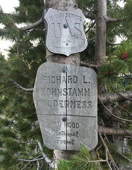
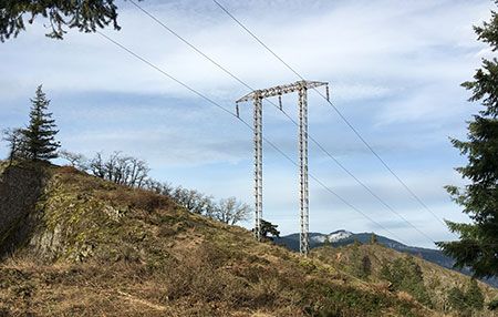
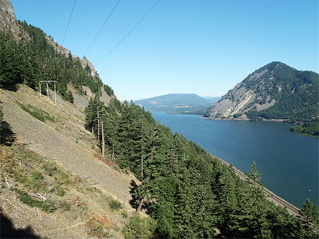
Among these, the Richard L. Kohnstamm Memorial Area expanded the Mount Hood Wilderness to the east of Timberline Lodge to encompass the White River canyon, extending from Mount Hood’s crater to about the 5,000 foot level, including a segment of the Timberline Trail and Pacific Crest Trail that traverses the canyon. This wilderness addition was created to “recognize the balance between wild and developed areas in the national public lands system and to create a tribute to the man who saved Timberline Lodge.”

The wilder side of the Timberline area is now the Kohnstamm Memorial Area, an extension of the Mount Hood Wilderness just east of the lodge

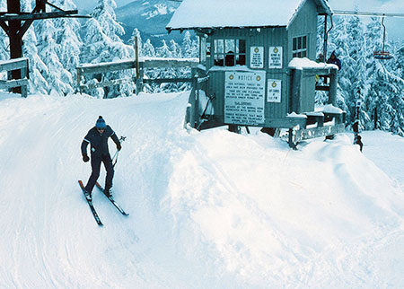
Richard Kohnstamm was the longtime force behind the RLK Company, operators of the Timberline Resort, which has a permit to operate the historic Timberline Lodge, which in turn is owned by the American public. 

After his duty as a gunner during World War II, Kohnstamm returned home to earn his masters degree in social work from Columbia University. After college, he moved to Portland to take a job at a local social services non-profit. Soon after arriving here, he made a visit to Timberline Lodge, where he was immediately taken with the beauty of the massive building. 

Richard Kohnstamm at Timberline in 1957 (Oregon Encyclopedia)

But Kohnstamm saw a tarnished jewel, as the lodge had quickly fallen into disrepair following its construction by the Works Progress Administration in 1937. The Forest Service had revoked the operating permit for the lodge and was looking for a new operator, and so began the Kohnstamm era at Timberline. By all accounts, he did, indeed, save the lodge. 

Kohnstamm soon teamed with John Mills to found the Friends of Timberline, a non-profit dedicated to preservation of the history, art and architecture of the remarkable building. The unique partnership between the Forest Service, Friends of Timberline and the RLK Company to preserve the lodge in perpetuity continues to this day, and is known as the Timberline Triumvirate. 

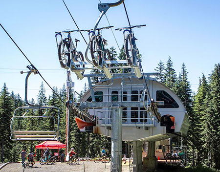
Today, the lodge continues to thrive, and summer resort operations have now expanded to include a controversial bike park centered on the Jeff Flood chairlift. After years of legal challenges, the RLK Company build miles of bicycle trails descending from main lodge to the base of the lift, where cyclists can load themselves and their bikes for a quick ride back to the top. 

The Timberline Resort’s new bike park opened this summer (photo: Timberline)

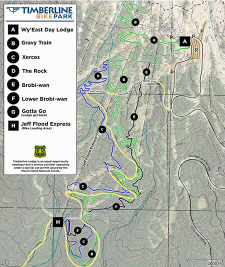
It’s a high-adrenaline activity made easy, with no hills to climb. But the development of this new attraction underscored the fact that the Timberline resort operators and Forest Service have done little over the decades to enhance the hiking experience around the lodge, despite plenty of demand. 

The reason is pretty obvious: hikers don’t buy lift tickets. Yes, some hikers help fill the hotel rooms in summer, and still more stop by to support the restaurants in the lodge, but filling ski lifts continues to the focus at Timberline.

Bikes riding the Jeff Flood lift back to the lodge (photo: Timberline)

Today, hikers at Timberline are limited to walking along the Timberline Trail or hiking the Mountaineer Trail, a semi-loop that climbs to a lift terminal, where it dead-ends at a dirt service road. Hikers usually follow the steep, dusty road back to lodge to complete a loop.

But perhaps the Richard L Kohnstamm Memorial Area could be inspiration for the Forest Service and RLK Company to bring new trails to the area, and a create a more welcoming trailhead for visitors who aren’t staying at the lodging or paying to ride the resort lifts? In that spirit, the following is a concept for a new trail that would be an instant classic on the mountain, rivaled only by the popular Cooper Spur Trail on Mount Hood’s north side for elevation and close-up looks into an active glacier.

Proposal: Kohnstamm Glacier View Trail

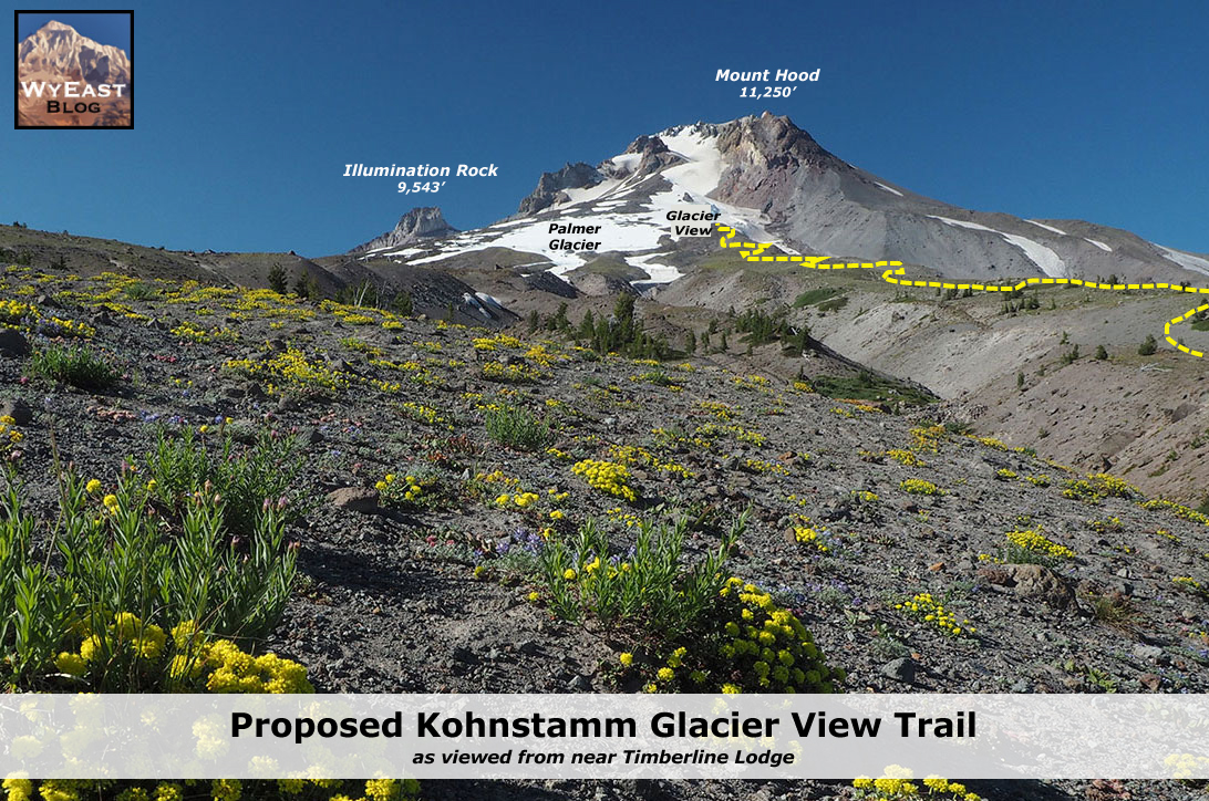
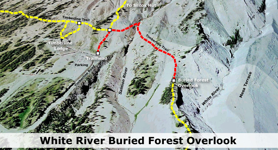
The proposed Glacier View Trail would climb the broad ridge that separates the White River and Salmon River canyons, just east of Timberline Lodge. The new trail would begin just across the Salmon River from the lodge, at a junction along the Timberline Trail, and end at Glacier View, a scenic high point on the ridge between the Palmer and White River glaciers. 

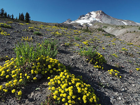
This viewpoint is already visited by a few intrepid explorers each year for its spectacular views into Mount Hood’s crater and the rugged crevasses of the White River Glacier. The schematic below shows how the new route would appear from Timberline Lodge:

(click image to enlarge)

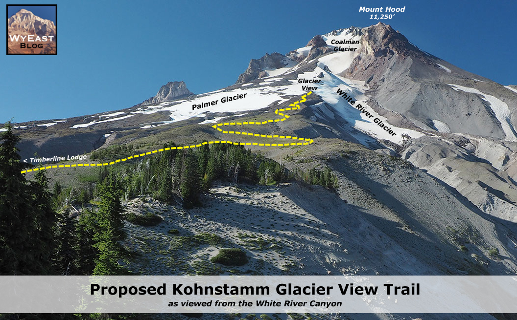
Another perspective (below) of the proposed trail shows the route as it would appear from further east along the Timberline Trail, where it travels along the rim of White River canyon. This angle also shows the tumbling descent of the White River Glacier and the steep west wall of the canyon that would provide several overlooks from the new trail:

(click image to enlarge)

Thanks to the gentle, open terrain, the new trail would climb in broad, graded switchbacks, eventually reaching an elevation of 8,200 feet. This is just shy of the elevation of Cooper Spur, and would make the Kohnstamm Glacier View Trail the second-highest trail on the mountain.

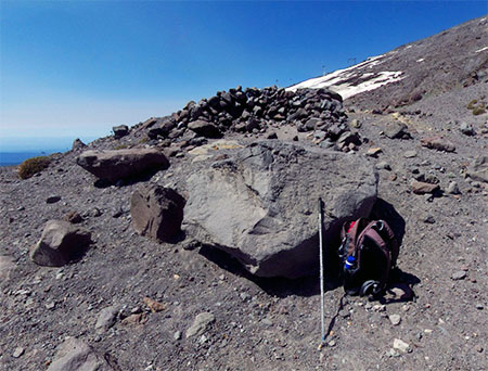
The viewpoint at Glacier View (below) is already marked by a stone windbreak built by hikers that complements several handy boulders (below) to make this a fine spot for relaxing and taking in the view.

End of the trail at Glacier View (photo: Google)

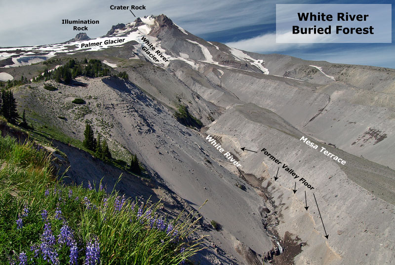
From the Glacier View viewpoint, Mount Hood’s crater and the upper reaches of the White River Glacier (below) are surprisingly rugged and impressive, given the generally gentle terrain of Mount Hood’s south side. From this perspective, the Steel Cliffs and Crater Rock dominate the view as they tower over the glacier.

Mount Hood’s crater and the upper reach of the White River Glacier from Glacier View (photo: Google)
White River Glacier from Glacier View (photo: Google)

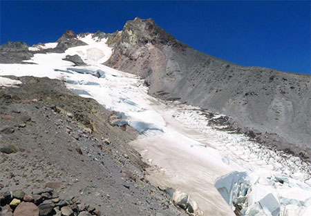
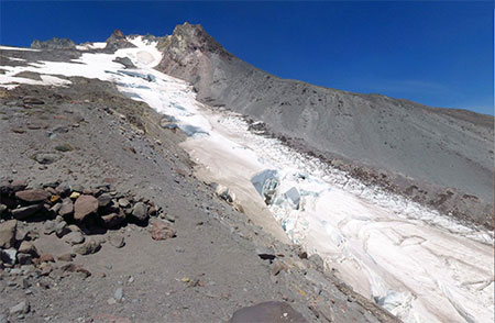
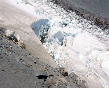
But the scene-stealer is the White River Glacier, which stair-steps down a series of icefalls directly in front of Glacier View (below), providing a close-up look into the workings of an active glacier. Lucky hikers might even hear the glacier occasionally moving from this close-up perspective as it grinds its way down the mountain.

Crevasses in the White River Glacier below Glacier View (photo: Google)

The view to the south from Glacier View (below) features the long, crevasse-fractured lower reaches of the White River Glacier, and below, the maze of sandy ravines which make up the sprawling White River Canyon. The deserts of Eastern Oregon are on the east (left) horizon from this perspective, and the Oregon Cascades spread out to the south.

The view down the White River Canyon from Glacier View (photo: Google)

The hike to Glacier View from Timberilne Lodge on the proposed Kohnstamm Trail would be about 2.5 miles long, climbing about 2,300 feet along the way, and would undoubtedly become a marquee hike on the mountain, if similar trails like Cooper Spur and McNeil Point are any gauge. But the backlog of trail needs at Timberline extend beyond having a marquee viewpoint hike like this. 

The Kohnstamm trail concept therefore includes other trail improvements in the Timberline area that would round out the trail system here. The following schematic (below) include building a new 1.4 mile trail from the upper stub of the Mountaineer Trail to Timberline Lodge, allowing hikers to complete the popular loop without walking the dusty, somewhat miserable service road below Silcox hut, often dodging resort vehicles along the way.

(click image to enlarge)

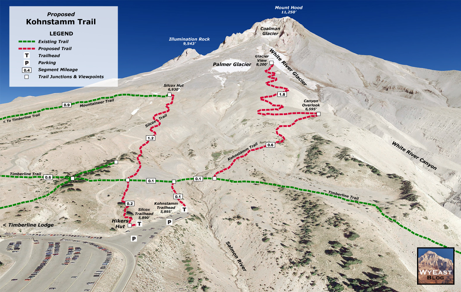
The broader Kohnstamm trail concept also calls for using the east parking area as a day-hiking hub in the summer months, with clearly marked trailheads that would consolidate the maze of confusing user trails that are increasingly carving up the wildflower meadows here. The new hub would also include restrooms, interpretive displays, picnic tables and other hiker amenities that would make for a better hiking experience.

Time for a makeover? Abandoned lift terminal at the proposed trail hub

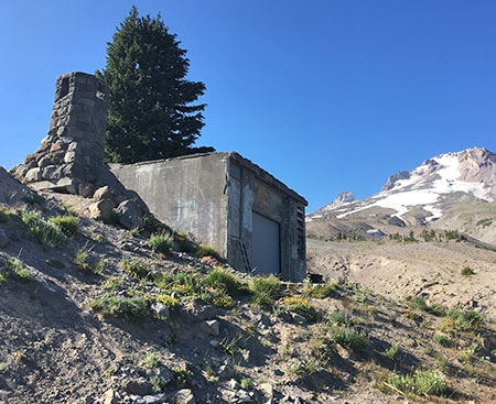
A more ambitious element of the concept is to convert the neglected bones of an abandoned lodge structure (above) at the east parking area to become a hiker’s hut where visitors could relax after a hike, fill water bottles or learn about hiking options from Mount Hood’s volunteer trail ambassadors. 

This element might even tempt the Timberline resort operators to help make these trail concepts a reality if it offered an opportunity to provide concessions to hikers. After all, hiking is the fastest growing activity on the mountain (and on public lands), not skiing (or even mountain biking). Creating a hiking hub could be an opportunity for the Timberline operators to evolve their future vision for the resort to better match what people are coming to the mountain for.

What would it take?

Trail building is typically heavy work that involves clearing vegetation and building a smooth tread where rocks and roots are the rule. But the proposed Kohnstamm Trail would be very different, as the entire route is above the tree line and would be on the loose volcanic debris that makes up the smooth south side of Mount Hood. Trail building here would be much simpler, from the ease of surveying without trees and vegetation to get in the way, to actual trail construction in the soft soil surface. For these reasons, much of this work would be ideal for volunteers to help with.

In reality, the greatest obstacles to realizing this concept would likely be regulatory. Convincing the Forest Service to permit a new trail would be a tall hurdle, in itself. But if the Timberline resort operators were behind the idea, it would almost certainly be approved, especially if the resort embraced building and maintaining the trail hub improvements. Who knows, maybe they will even spot this article..?

Author’s Confessions…

As a postscript, I thought I’d post a few confessions from days of yore. I grew up in Portland and began skiing at Timberline Lodge as a tiny tot. I continued to avidly ski at the Mount Hood resorts for many years until giving up alpine skiing in the early 90s, largely in response to the expansion of the Meadows resort into lovely Heather Canyon, a deal-breaker for me. I loved the sport, but saw the beauty of the mountain under continual threat from the resort operations — and still do. Today, I make due with snow shoes and occasional trips on Nordic skis, though I do miss the thrill of alpine skiing!

The author skiing Timberline in 1978

An earlier awakening for me came in 1978, with the construction of the Palmer Lift at Timberline. This lift completed Richard Kohnstamm’s vision for year-round skiing on the mountain. But it was the first lift on Mount Hood to climb that far above the tree line, and was an immediate eyesore. Sadly, the conversion of the Palmer Glacier to become plowed rectangle of salted snow (see “Stop Salting the Palmer Glacier!”) that can be seen for miles completed the travesty.

That Palmer Lift debacle was soon followed by an even more egregious lift at Mount Bachelor, one that I wrote about 37 years ago in this (ahem!) riveting bit of self-righteous student journalism! (below)

(click image to enlarge)

When I stumbled across this old clipping from my days as a columnist at the Oregon State University student newspaper, I initially winced at the creative flourishes (…hey, I was 20 years old!). But my sentiments about these lifts — and the Heather Canyon lift at Meadows — remain unchanged. They were a step too far, and represented a real failure of the Forest Service to protect the mountain from over-development.

That said, I do believe the ski resorts can be managed in a more sustainable way that doesn’t harm the mountain. We’re certainly not there yet, and because all three of the major resorts (Timberline, Ski Bowl and Meadows) all sit on public land, I believe we all have a right to help determine that more sustainable future. 

In this article, I’ve made a case for accommodating more than just lift ticket purchasers in the recreation vision at Timberline Lodge. In future articles I’ll make the case for rounding out the mission for the other resorts in a way that meets the broader interests of those of us who own the land.

First Look at the Gorge Fire

GorgeFire01

Eagle Creek Fire during the initial, explosive phase (US Forest Service)

Officially the Eagle Creek Fire in the Columbia River Gorge is still fully involved, now at 35,000 acres and just 10 percent contained by firefighters. Rain in the forecast for the coming week suggests that the fire will continue to slow as October approaches, and our attention will turn toward the changes that fire has once again brought to the Gorge.

The Gorge is a second home for many of us, and in some ways the fire was akin to watching our “home” burn. But that’s a human perspective that we should resist over the long term if we care about the ecological health of the Gorge. Fire is as natural and necessary as the rain in this amazing place, though that’s a truth that we have been conditioned to resist. I’ll post more on that subject in a subsequent article.

GorgeFire02

Surreal Gorge landscape under smoky skies from the Eagle Creek Fire (US Forest Service)

For now, we’re just beginning to learn about the impact of the fire, even as it continues to burn. Thankfully, no lives have been lost, no serious injuries reported and very few structures have been lost. That’s a testament to our brave emergency responders (many of them volunteers) and the willingness of most Gorge residents to abide by evacuation orders. It has surely been a frightening and stressful time for those who call the Gorge home.

The impact on public lands is still largely unknown, but the Oregon side of the Columbia River Gorge has one of the most concentrated, most heavily used trail systems in the world, and the damage to trails is likely to be significant. The Forest Service is likely to close affected trails for months or even years in order to assess the damage and determine how best to restore them.

GorgeFire03

1930s hiker at a viewpoint along the Perdition Trail (with Multnomah Falls beyond)

If you’ve lived here for awhile, you’ll also recall that we lost the Perdition Trail, an iconic, prized connection between Wahkeena Falls and Multnomah Falls, to the 1991 Multnomah Falls Fire. The reasons were complex, and it will tempting for the Forest Service to let some trails go, given their shrinking trail crews. We should not allow this to happen again.

Every trail should be restored or re-routed, and new trails are also needed to spread out the intense recreation in the Gorge. Trails advocates will need to work together to ensure this. Trailkeepers of Oregon (TKO) has set up a mailing list dedicated to Gorge trail restoration, if you’re interested in working on future volunteer projects. You can sign up for periodic updates and events here.

______________________

On September 10, I drove SR 14 on the Washington side of the Gorge for my first look at the fire, starting in Hood River. Below each of the following annotated photos, I’ve linked to much larger versions that I encourage you to view if you’re reading this on a large monitor, as they provide a better sense of the fire’s impact.

As hoped, much of the burn is in a patchy “mosaic” pattern, a healthy and desirable outcome for the ecosystem. This is how fires used to occur in our forests, before a century of suppression began in the early 1900s. Mosaic burns allow for mixed forest stands and exceptional wildlife habitat to evolve, even as we might mourn the loss of familiar green forests.

The wind pattern on Sunday had shifted from westerly to a northwesterly direction, producing a bizarre effect: smoke from the fire hugged the vertical wall that is the Oregon side of the Gorge, while the Washington side was cleared of smoke and under a bright blue sky. The view, below, shows this split-screen effect from near Wind Mountain.

GorgeFire04

(Click here for a large view)

Moving west, the combination of ongoing wildfire and back-burning by firefighters was producing a continuous plume along the base of the Oregon cliffs, from Herman Creek east to Shellrock Mountain, as seen below. The Pacific Crest Trail traverses this section, and is undoubtedly affected by the fire.

GorgeFire05

(Click here for a large view)

From the Bridge of the Gods wayside, opposite Cascade Locks, the impact of the fire on the canyons that fan out from Benson Plateau is visible. Some areas (below) show a healthy mosaic burn, while some of the upper slopes show wider swaths of forest impacted. The alarming proximity of the fire to the town of Cascade Locks is also evident in the scorched trees visible just above the bridge in this view. This was a close call for those who live here.

GorgeFire06

(Click here for a large view)

Turning further to the east from the Bridge of the Gods wayside (below), the ongoing wildfire and back-burning shown in the previous photos can be seen in the distance, beyond the town of Cascade Locks.

GorgeFire07

(Click here for a large view)

The scene at the Bridge of the Gods bridgehead (below) is an ongoing reminder that we’re a long way from life returning to normal for Cascade Locks residents. For now, I-84 remains closed and this is the only route into town, and only open to those with proof of residency.

GorgeFire08

(Click here for a large view)

Moving further west, the 2000-foot wall of cliffs in the St. Peters Dome area that stretches from McCord Creek to Horsetail Creek (below) come into view.

Here, the fire has also burned in mosaic pattern, with many patches of green forest surviving. But the frightening effects of the firestorm that occurred in the first days of the fire is also evident, with isolated trees on cliffs hundreds of feet above the valley floor ignited by the rolling waves of burning debris that were carried airborne in the strong winds that initially swept the fire through the Gorge.

GorgeFire09

(Click here for a large view)

A second view (below) of the St. Peters Dome area shows the burn extending toward Nesmith Point, nearly 4,000 vertical feet above the Gorge floor.

GorgeFire10

(Click here for a large view)

Moving west along SR 14 to the viewpoint at Cape Horn, the impact of the fire on areas west of Horsetail Falls comes into view (below), along with a better sense of the mosaic pattern of the burn. This view shows the Horsetail Creek trail to be affected by the first, as well as the slopes on both sides of Oneonta Gorge.

In this earlier piece on Oneonta Gorge, I described the dangerous combination of completely unmanaged visitor access and an increasingly dangerous logjam at the mouth of the Gorge. The fire will almost certainly trigger a steady stream of new logs rolling into Oneonta Gorge and adding to the massive logjam in coming years.

GorgeFire11

(Click here for a large view)

Moving further west, the area surrounding iconic Multnomah Falls and Wahkeena Falls comes into view (below). As with other areas, the fire burned in vertical swaths along the Gorge face, leaving more mosaic patterns in the burned forest. From this view, trees along the popular 1-mile trail from Multnomah Falls Lodge to the top of the falls looks to be affected by the fire, as are forests above Wahkeena Falls.

GorgeFire12

(Click here for a large view)

This wide view looking east from above Cape Horn (below) shows most of the western extent of the fire, with the north-facing slopes of Angels Rest heavily burned, while the west and south-facing slopes were less affected.

GorgeFire13

(Click here for a large view)

A closer look at Angels Rest shows that the burned area in the current fire closely matches the area that burned in the 1991 (below), along with slopes on the opposite side of Coopey Falls. The Angels Rest Trail was heavily impacted by the 1991 fire, and will clearly need to be restored after this fire, as well.

GorgeFire14

(Click here for a large view)

I’ve marked an approximation of the 1991 fire extent at Angels Rest in this closer look (below) at the summit of Angels Rest, based on tree size. Tall conifers burned in today’s Eagle Creek fire survived the 1991 fire, and mark the general margins of that earlier fire.

Areas within the 1991 burn were still recovering and consisted largely of broadleaf trees, like Bigleaf and Vine maple. Depending on the heat of the fire and whether their roots survived, these broadleaf trees may be quick to recover, sprouting from the base of their killed tops as early as next spring.

The recurring fires at Angels Rest offer an excellent case study for researchers working to understand how natural wildfires behave in successive waves over time. This, in turn, could help Gorge land managers and those living in the Gorge better plan for future fires.

GorgeFire15

(Click here for a large view)

Finally, a look (below) at the western extent of the fire shows a few scorched areas in Bridal Veil State Park, including the forest around the Pillars of Hercules. Bridal Veil Canyon appears to have escaped the burn, though some trees near Bridal Veil Falls may have burned.

GorgeFire16

(Click here for a large view)

I’ve titled this article as my “first look” because the story of the Eagle Creek fire is still being written. Only after the fall rains arrive in earnest will we have a full sense of the scale of the fire.

As new chapters in the Eagle Creek saga unfold, I’ll continue to post updates and share perspectives on this fire and our broader relationship with fire as part of the natural systems that govern our public lands. With each new fire in close proximity to Portland, we have the opportunity to expand and evolve how we think about fire, and hopefully how we manage our public lands in the future.

More to come…

Big Changes coming to the Gorge Power Line…

GorgePowerline02

These venerable steel towers will soon be a memory in the Gorge


Author’s preface: having spent more than 30 years in public service, it frustrates me to see any level of government making anything less than a consistent, substantial and meaningful effort to engage the broader public in its decision making. All public entities should be held to this high standard, whether local, state or federal.

So, when I stumbled across the Bonneville Power Association (BPA) decision to significantly rebuild the prominent power line corridor that links Bonneville Dam to Hood River, I was disappointed to learn that the decision involved a handful of select stakeholders and two short windows for public comment that saw little notice or participation. We should expect more, and the BPA should step up its commitment to real public engagement, not meager efforts that do little more than check regulatory boxes.

_______________

According to a retired BPA employee who once joined me on a hike near Starvation Creek, the daring alignment of the power line corridor that provided the first electricity from Bonneville Dam to Hood River is the doing of no less than Franklin D. Roosevelt. As the story goes, FDR was on his famous tour of the Mount Hood Loop Highway on September 28, 1937, with stops to inspect Bonneville Dam and dedicate Timberline Lodge.

GorgePowerline03

BPA workers building the daring new power lines across Shellrock Mountain in 1937 (BPA)

After leaving Bonneville, FDR asked about the power lines that were under construction, and a BPA official told the president they would be built on slopes high above the Gorge, where the terrain was easier to navigate. FDR reportedly barked at the official “I want those power lines down here, where the people can see the electricity that we’re bringing to their communities!”

So began the project to build the BPA power lines across the rugged cliff faces of the Columbia River Gorge. Amazingly, most of the work was done by hand, with pack mules carrying materials to the often dizzying cliff-top tower locations. While it’s hard to view any power line as “scenic”, the sheer audacity in how these towers were designed and built can’t help but impress hikers passing under them today.

GorgePowerline04

The Shellrock Mountain power line and trail today

The Bonneville to Hood River corridor is one among many power lines that transmit hydro-power along the Columbia, but this corridor is notable in that much of it is serviced through a network of trails where the terrain was too extreme to support service roads. Many of these trails have morphed into recreation trails over the years.

Big Changes Coming this Summer

GorgePowerline05

Trees marked for cutting at Viento State Park

After eighty years of maintaining the Gorge power line corridor in much the same state, the BPA is about to significantly change both the look of the towers and some of the access routes. I stumbled across this reality earlier this spring when I was exploring the area above Viento State Park, where I encountered a few dozen mature Douglas fir marked for cutting.

At first, I thought it might be a thinning project of some sort, but upon some research, discovered that the BPA was about to replace all of the steel towers and many of the wood pole towers along the corridor and expand several of the access spur roads. Up to 30 of the new towers will be steel “mono-poles”, a departure in both look and height from somewhat rustic old structures that now exist on the corridor.

The project also proposes to remove up to 747 trees to allow access roads to be widened and rebuilt, and the BPA proposes “temporary disturbance” to over 58 acres and “permanent disturbance” to about one-third of an acre.

GorgePowerline06

More trees marked for cutting in the Gorge power line corridor

For the scoping phase of this project, the BPA opened a public comment period of six weeks and held a public meeting in Hood River in the spring of 2014. They received 12 written comments during the scoping phase and four people attended this meeting. Sadly, this dismal turnout was during the critical window for raising issues to be considered by the BPA as part of the environmental assessment.

The agency also reached out to tribes and a few interest groups they have long engaged in their public outreach, but their effort falls short of a meaningful commitment to fully engage the public, as evidenced by the meager input they received. The BPA held a second public meeting and opened a final six-week comment period on the draft environmental assessment last fall. As one of the largest and most reliably funded public agencies in existence, the BPA can and should do better.

Who Weighed in?

GorgePowerline07

The BPA’s overly aggressive removal of native vegetation in the power line corridor and subsequent abundance of invasive species was a theme in comments received

While the BPA received very little input from their limited effort to reach out to the public, there were a few commenters. The Friends of the Columbia River Gorge were one again our reliable and invaluable watchdogs in the Gorge weighed in with extensive comments, including the following on the BPA proposal:

[The BPA should] mitigate scenic impacts by installing new structures that would be less visually discordant in the landscape. Where steel towers are needed, we ask that weathering steel be employed to reduce visibility.

Include a robust invasive species eradication and restoration strategy. The BPA transmission line corridor is frequently infested with invasive plants, such as Armenian blackberry. While replacing structures, BPA should remove invasive plants and restore native vegetation communities that would be compatible with long-term vegetation management requirements. 


BPA should also thoroughly document existing native vegetation communities and determine the need for future vegetation management. BPA’s past vegetation removal efforts have removed vegetation that poses no threat to the transmission line system, which unnecessarily harms wildlife habitat and creates openings for invasive plants.

The Pacific Crest Trail Association also weighed in, with concerns about how the proposed changes could degrade the PCT where the power line crosses the trail near the Bridge of the Gods trailhead. Among their concerns:

The existing view from the trail is a long line of sight down a decidedly unnatural appearing power line corridor, crisscrossed with roads. Forest Service scenery management principles dictate that developments viewed from a sensitive viewing area should strive to mimic “the form, line, color, texture, and pattern common to the landscape.”

Contrary to this, the improved roads will stand out visually as artificial, in what’s already an artificial corridor of cleared vegetation. The improvements would disrupt the PCT traveler’s experience because they clearly mark human manipulation and diminish the desired sense of remoteness from civilization.

While it’s suboptimal for the PCT to follow any road at all, at least the existing condition of the road is rustic. Upgrades to the road, including resurfacing with imported materials, will make it appear and feel more industrialized for the PCT traveler. A related effect, because the road is already dominant over the trail, is that people get lost and continue to follow the road, despite trail signage. Improving the road would exacerbate this situation. 


 The trail crosses directly under one of the structures, in fact, between the poles and their guy lines. This site can’t help but appear impacted by the proposed improvements. There will be three poles instead of two, and, clearly a good deal of ground disturbance involved in upgrading this structure. 


These exacerbated visual impacts to the trail could be best ameliorated by reconfiguring the intersection, and reconstructing portions of the PCT where necessary to meet the BPA line in a spot that lends itself better to disguise. Such a trail relocation would be as much as .5 mile long, and would require its own NEPA study. We propose that this NEPA study, and subsequent trail construction by PCTA’s volunteer crews, be funded by BPA as a mitigation measure. 


The Columbia River Gorge National Scenic Area (CRGNSA) unit of the U.S. Forest Service wrote extensive comments, mostly reminding the BPA of regulatory requirements related to the Gorge and the need to conduct environmental assessments when trails or other recreation facilities within the corridor would be significantly impact. The CRGNSA did not comment on opportunities to improve the access trails along the corridor to serve as recreational trails.

What to Expect this Summer?

This project is now going forward in largely the form that was first proposed in 2014 as the preferred action by the BPA. What does this mean for your favorite trails in the Gorge? Here’s are some key excerpts from the BPA’s 410-page draft environmental assessment, beginning with a project overview:

“The Proposed Action is to: (1) rebuild portions of the Bonneville-Hood River transmission line within the rebuild area for the Project (the 22-mile-long segment from structure 1/5 to the Hood River Substation); (2) rebuild the Cascade Locks Tap [author’s note: this is the point where the community of Cascade Locks taps into the power line corridor]; and (3) improve and extend the access road and trail system that allows BPA access to and from the transmission line. Specifically, the Proposed Action would involve the following components:

  • Removal of wood-pole and lattice-steel H-frame transmission line structures constructed prior to 1999 (including cross arms, insulators, hardware, and guy wires) and replacement with a combination of wood-pole H-frame structures and steel-monopole structures. 

  • Retirement of unnecessary transmission line structures. 

  • Replacements of conductors and guy wires. 

  • Replacement of insulators and hardware in locations with no structure or conductor replacement. 

  • Improvement, reconstruction, and extension of existing access roads and trails. 

  • Installation or replacement of bridges, fords, culverts, and access road gates. 

  • Establishment of temporary staging areas, helicopter flight yards, and tensioning sites (for pulling and tensioning conductors). 

  • Installation of temporary guard structures for stringing lines over roads and other utilities. 
  • Removal of vegetation at various locations along the transmission line right-of-way and access 
roads. 

  • Re-vegetation of areas disturbed by construction activities.

Hikers are mostly likely to notice the changes on trails that also serve as access to the power lines or cross the corridor, including the Pacific Crest Trail, Starvation Ridge, Mount Defiance, Wygant and Mitchell Point trails. Off-trail explorers will also see changes in the bluffs above Viento State Park and on Shellrock Mountain.

GorgePowerline08

The Mount Defiance and Starvation Ridge Trails could be noticeably affected where they pass through the power line corridor

Here’s an except from the environmental assessment that describes the changes we will likely see in these places:

“BPA currently uses a combination of existing roads and foot trails to access the transmission line. BPA holds permits and access road and foot trail easements for access across public and private land. Through these permits and easements, BPA has previously constructed roads and foot trails to access the transmission line. These access roads and foot trails are primarily located within the transmission line right-of-way, but there are also some access roads and foot trails located outside the right-of-way where required due to terrain constraints or other factors.

In a few locations, BPA currently does not have express easement rights to use some existing roads or foot trails that provide access to the transmission line. At these locations, BPA would acquire about 4.4 miles of easement rights to use various sections of the existing roads and trails. Generally, BPA obtains a 50-foot-wide easement for access road rights and 20-foot-wide easements for foot trails.  

BPA’s existing access roads for the line are typically 14 feet wide with an additional 3-foot offset from each side for slopes or drainage ditches, resulting in a total disturbance width of about 20 feet. Access road reconstruction and improvement activities associated with the Proposed Action would occur within this prism, except in areas with curves or on steep slopes where work would occur outside of this prism because of necessary cut and fill.

In areas with identified sensitive resources, such as wetlands or sensitive habitat, access road widths would be reduced to 12 feet and the offsets on either side would be reduced to 2 feet, for a total area of disturbance of 16 feet to minimize temporary and permanent impacts.  

Trail reconstruction or extension activities would result in a typical trail bed width of 18 inches that would require a total clearing area of 2 to 4 feet. For trails crossing steep talus areas, such as Shellrock Mountain, trail bed widths may be as small as 12 inches due terrain constraints. To provide trail stability in these steep areas, sideboards would be installed with rebar or rocks would be keyed into the hill.

On talus slopes, the trail bed would be comprised of compacted course surface material. In non-talus areas, the trail bed would be at grade and would consist of native material. All trail work areas would be accessed by foot and trail improvement, reconstruction, or extension work would be conducted with hand held equipment.”

More information on the project can be found on the BPA’s project website.

It’s never to late to be heard…

GorgePowerline09

BPA power line tower to be replaced on the Viento Bluffs

With a little more effort in their public outreach (like contacting trail organizations), the BPA would certainly have heard plenty of comments from the general public, and especially from hikers who regularly visit the corridor. Much of the commentary would likely have focused on how popular trails like Starvation Ridge and Mount Defiance will be impacted by the project.

But it could also have been an opportunity for hikers to propose expanded use of the power line trails by hikers, including areas like Shellrock Mountain and the area between Starvation Creek and Viento Creek that have tremendous scenic value. While the Forest Service declined to call out this opportunity, these trail sections also could help complete Gorge Trail 400.

No doubt the BPA wouldn’t be enthusiastic about bringing more hikers to the corridor, but the land belongs to the public and there’s no reason not to make full use of the routes the BPA will be building and maintaining with our public funds.

GorgePowerline10

The BPA corridor crossing Shellrock Mountain (BPA)

Is it too late to weigh in? Yes, for the most part. The project entered the final stage of the environmental impact process this spring and is scheduled to move into construction this summer. But if you’re concerned about how the construction is proceeding on the ground, you can contact the BPA directly with your concerns or comments:

Chad Hamel

Project Manager

Bonneville Power Administration

P.O. Box 61409

Vancouver, WA  98666-1409

Tel 800-622-4519

The most interesting section of BPA trail that is not currently a signed route is the trail over Shellrock Mountain. While this is only for the most experienced hikers today, it’s a great adventure that includes magnificent views of the Gorge that few enjoy. Hopefully, this route will someday be connected to Gorge Trail 400 — as it should have been as part of this project.

In the meantime, consider exploring the corridor by visiting the connecting trails at Mitchell Point, Wygant Peak, Starvation Creek and where the PCT crosses the corridor on the route to Dry Creek Falls.

Most of the land in the corridor is in public ownership and managed by Oregon Parks and Recreation or the U.S. Forest Service, so you are free to walk the trails and service roads here. This is the best way to see first-hand how your public lands are being managed, even if the BPA has let us down in their efforts to involve the public in this project.

White River Buried Forest

The summer of 2011 will be remembered as the year of the Dollar Lake Fire in the Mount Hood area, as much of the north side is still smoldering from a lightning-caused wildfire that ignited on August 26. Though a calamity to those who loved the verdant forests on Mount Hood’s northern slopes, the fire is a blip on the screen when compared to the many explosive events that have rearranged the mountain’s forests and topography over the millennia.

Among the most recent and fascinating of these events are the Old Maid eruptions. These explosions knocked over entire forests on the mountain’s south side like matchsticks, burying them under a deep layer of ash and volcanic debris. This article describes the Old Maid events, and how to see traces of their aftermath today.

The Old Maid Eruptions

While most tourists at Timberline Lodge on a given day are blissfully unaware that Mount Hood is living volcano, the occasional, heady odor of sulfur fumes blowing down from the crater are a reminder the “quiet” spell we are enjoying is only temporary.

[click here for a larger version]

In geologic terms, the Old Maid eruptions are incredibly recent, finally winding down in our recorded history of the early 1800s. The events are named for Old Maid Flats, the debris plain created by the eruptions in the Sandy River canyon, though the impact on the mountain was much broader.

Scientists have determined the Old Maid eruptive period to have occurred within from about 1760 to 1810 A.D. In fact, when Lewis & Clark described the shallow “quicksand” delta of the Sandy River in 1804-05, they were looking at volcanic sediments that had only recently flooded down the river from the active slopes Mount Hood.

The former floor of the White River canyon is visible as a thin layer of oxidized soil, dotted with mummified trees.

The scientific accuracy of these dates is made possible by thousands of mummified trees swept over by the Old Maid debris flows, and later exposed by streams cutting into the sediments. The White River buried forest is one of the more prominent locations where these flattened forests and the former valley floor can plainly be seen.

The Old Maid eruptions originated in the modern crater of Mount Hood, where sulfur fumes still rise from the vents known as the Devils Kitchen. The massive, 800-foot volcanic dome of Crater Rock, itself, is just 200 years old and formed during these eruptions. The heat of rising magma in the crater eventually sent pyroclastic flows down the Sandy and White River canyons — rolling clouds of super-heated ash and debris that buried the entire landscape.

A closer look at the buried valley floor reveals mummified trees.

The Old Maid eruptions deposited about one hundred feet of debris throughout the upper White River canyon, filling the formerly U-shaped glacial valley with a flat fan of volcanic boulders, cobbles and fine ash. The outflow from the White River Glacier has since carved deeply into the debris flow, revealing the old valley floor and some of the thousands of mummified trees knocked over by the Old Maid event.

A flat-topped ridge in the middle of the White River canyon known as Mesa Terrace (see earlier schematic) is a remnant of the debris flow that shows the original depth of the debris above the valley floor.

Close-up of an entire tree, tipped over and buried where it fell on the former valley floor.

Two types of debris flow swept down the southern slopes of Mount Hood during the Old Maid eruptions. The most destructive were the pyroclastic flows, which many of us are familiar with from the colossal Mount St. Helens eruption of May 18, 1980.

In addition to the hot pyroclastic flows, cooler mudflows from flash-melted glaciers and snowfields also swept down Mount Hood’s south slopes during the Old Maid events. We know the buried forests at the bottom of White River Canyon fell victim to these mudflows, as pyroclastic flows would have instantly incinerated the standing timber. Instead, the cooler debris flows simply knocked the forests over, and buried them under layers of mud and debris.

Scientists believe these trees were partially buried, then broken off by subsequent flows.

Scientists believe the old valley floor now being revealed by erosion was of glacial origin, dating back to the last major glacial advance of the White River Glacier some 10,000 years ago. Thus, forests grew undisturbed along the former valley floor of the White River for a very long time.

Hiking to the Overlook

Hiking to the White River buried forest overlook is easy and scenic, as well as historic and iconic: it follows Mount Hood’s famous Timberline Trail for 0.7 miles to the impressive rim of the White River canyon. This section of trail also serves as the Pacific Crest Trail, the 2,000-mile epic trek from Mexico to Canada.

To find the trailhead, park in the lower, overflow lot located to the east of Timberline Lodge. Park near a gated dirt on the west side of the parking area. Follow this old road steeply uphill for about 200 yards to an obvious junction with the Timberline Trail, and turn right (or, if you’re coming from the lodge, follow any of the trails beyond the lodge uphill to the Timberline Trail and turn right). The Timberline Trail quickly traverses into a side-canyon, crossing the headwaters of the Salmon River.

Next, the Timberline Trail rambles across pumice-covered slopes and soon reaches a sign marking the Richard L. Kohnstamm Wilderness, created in 2009 as an addition to the wilderness complex that encircles Mount Hood. Kohnstamm was the resort operator responsible for resurrecting a struggling Timberline Lodge in the 1950s, and setting the resort on the successful path that it continues to enjoy today.

[click here for a larger, printable map]

Beyond the wilderness boundary, the trail descends across another pumice slope, then drops more steeply on a surface of loose glacial till as it traces the west moraine of the White River canyon. Soon, you will reach the overlook where the Timberline Trail follows the moraine crest, and arrives at a stand of trees. This is a good spot to stop and take in the scenery, and especially to pick out the signs of the buried forest, at the bottom of the canyon, below.

The south-facing slopes and open terrain can make this a hot, dusty hike in late summer, so be sure to carry water. You will also want a pair of binoculars to view the buried forest details more closely. If you have the time and energy after visiting the buried forest overlook, you can retrace your step to the dirt access road, then turn right and follow it to Silcox Hut, about 0.8 miles from the trailhead. The hut was the original upper terminal for the first Magic Mile ski lift in the late 1930s, and today is maintained as an historic structure.

Discovering Bald Mountain

The country is filled with “Bald Mountains”, but for sheer scenic spectacle, few can compare to the Bald Mountain that rises just four miles away from the towering west face of Mount Hood. At one time, a fire lookout stood atop this Bald Mountain, and the view from the tower must have been the envy of fire lookouts around the Northwest.

Today, Bald Mountain isn’t entirely bald, having grown a dense forest of noble fir along the crest and northern slopes over the past half-century. Yet, it was in the 1970s, when the Timberline Trail was rerouted to lead hikers across the steep, open meadows on the south slope of the mountain, that hikers became familiar with Bald Mountain. Today, this spectacular traverse continues to provide one of the most popular, exhilarating sections along the classic loop hike.

Though most visitors to Bald Mountain keep to the Timberline Trail, you can still follow the historic old path that leads to the former lookout site, with its magnificent, close-up views of Mount Hood. Thanks to the quiet efforts of a few anonymous volunteers over the decades, the trail remains open and lightly maintained, with only an occasional log to step over along the way.

As the old path climbs toward the summit, hikers find themselves in a dense, young forest, and have to use their imagination to picture the open slopes of beargrass — with no forests — that existed when the first lookout was built on “Bald” Mountain more than a century ago.

Along the old trail, hikers will also spot blazes on the few trees that stood at the time of the former lookout tower. These blazes mark most historic trails (see this recent article on blazes) in the Mount Hood area, and confirm that the present alignment of the summit path to Bald Mountain dates back to at least the World War II era, and likely before.

A look at the 1911 USGS map of Mount Hood (below) shows that a “lookout” stood on Bald Mountain long before roads crossed Lolo Pass, and decades before the Timberline Trail was built. The early lookout structure was likely no more than a wood platform, later replaced with a conventional lookout tower. Interestingly, the Beaver Lakes shown on the map have since faded away, too, filled in with forest:

The 1946 USGS map of the Mount Hood area (below) is the last to show a lookout on Bald Mountain (and the Beaver Lakes), but in the intervening years from the 1911 map, the Timberline Trail and Skyline Trail had been completed, with both routes passing just below the lookout.

In fact, it’s likely that the section of Skyline Trail from Lolo Pass to Bald Mountain was originally built for lookout access, since the trail over Lolo Pass was among the earliest built in the area, and in fact, followed an ancient Indian route connecting the Sandy and Hood River valleys.

The alternating ticks shown along the dashed trail segments on the 1946 map indicate a telephone line along the route. Today, these routes often have ceramic insulators still attached to trees, and on this route further suggest that this section of trail was originally built with the lookout in mind. The route is now part of the Pacific Crest Trail, which replaced the old Skyline Trail, and remains one of the best approaches for hiking to Bald Mountain.

What did the old tower look like?

Fire lookouts in the Pacific Northwest followed a few standard designs beginning in the 1930s, after much improvisation in the early lookout designs that were built through the 1920s. The Bald Mountain lookout probably followed this evolution, with some sort of simple platform beginning at the turn of the twentieth century, and later, a more substantial structure built to Forest Service standards.

We have a much more exact picture after June 1944, when archived Forest Service documents show a new lookout was designed, apparently to replace an existing structure on Bald Mountain. The following are samples from the 1944 architectural plans for Bald Mountain. There are no clear records of when this lookout was removed, but it was likely in the late 1950s or 1960s, when hundreds of lookouts were viewed as outmoded by the Forest Service and destroyed.

The cab — or cabin — in the 1944 designs for Bald Mountain is a 14×14 foot structure (above) that would closely resemble the surviving cab on the Devils Peak lookout, just to the southwest of Mount Hood in the Salmon-Huckleberry Wilderness. This simple design featured five windows per side and a low, pitched roof.

Inside the cab (below), the living space was organized around a Osborne fire finder, located in the center of the floor, surrounded by a wood stove, table, kitchen, storage cabinets, shelves and bunk. A catwalk wrapped around the outside of the cab, allowing lookouts to maintain the windows, raise and lower shutters and haul firewood and supplies up from below with pulleys.

The 14×14 foot cab rested atop a 43-foot wood-frame tower (below), complete with a spiraling stairway that ascended within the tower uprights. Though the tower was anchored directly to the ground, the main stabilization came from guy wires anchoring the tower to concrete footings in four directions.

The most remarkable aspect of this tower (and many others) is the fact that most of the materials were carried to the site over trails using livestock. That included the cut lumber, concrete, construction hardware, fixtures and windows — an amazing feat when you consider this was repeated dozens of times at lookout sites around the region.

The lookout plans for Bald Mountain also contain one “standard” element that wasn’t so standard, at least compared to other lookouts in the vicinity: a garage and storage shed built around the base of the tower. In this view, the stairway to the tower can be seen on the right, with the dashed lines above the garage marking the location of the tower uprights:

As this design detail from the 1944 plans suggests, there were a number of concrete footings used in the construction of the Bald Mountain lookout tower. Today, these seem to be the only remaining traces of the structure. Three footings are loose, and have been moved around and used by campers over the years. Other footings remain in the ground, mostly reclaimed by the undergrowth. This footing is located along the spur trail leading to the east viewpoint from the lookout site:

Visiting Bald Mountain

There is some irony in the historic Bald Mountain trail being “lost”, as the mountain is now almost completely circled by the Timberline Trail, and thousands of hikers make their way along this route every year. Almost all of these visitors walk right past the unmarked summit path leading to Bald Mountain.

But for those seeking the route less traveled, the hike to the summit is easy, provided you successfully navigate the maze of popular trails in the area. The key is knowing how to spot the unmarked junction with the Timberline Trail. Take a close look at this photo to help you recognize the spot if you choose to visit the old trail — this view is how the trail appears from either of the approaches described below:

From Lolo Pass: The Classic Approach

The classic hike begins at Lolo Pass, and follows the Pacific Crest Trail through handsome forests for three miles to the base of the Bald Mountain summit path. The total mileage on this option is 6.6 miles round trip, with an elevation gain of 1,400 feet. The following is a map of the Lolo Pass approach that accompanies the hike description I wrote for the Portland Hikers Field Guide:

Click here for a larger map

For a detailed description of the Lolo Pass approach, visit the Portland Hikers Field Guide page:

Lolo Pass to Bald Mountain Hike

The Field Guide description also includes driving instructions to the trailhead. This is a dry hike, so carry water — and in early summer, plan on the usual bugs that plaque hikers just after snow melt. My favorite time to hike this trail is on a clear day after the first autumn snow dusts the mountain in late September or October. This is when the area is free of bugs AND crowds.

From Top Spur: The Family Route

For a shorter hike that works well for families with kids (or for adults looking for a short afternoon or evening activity) you can also approach Bald Mountain from the Top Spur trailhead. Be forewarned that this is one of the most popular trailheads in the Mount Hood region, and mobbed on summer weekends.

But even on busy weekends, you can smile to yourself as you leave the crowds behind, and head up the quiet, old lookout path for some solitude — hidden in plain sight! From the summit viewpoint, you can literally look down on hikers passing hundreds of feet below on the Timberline Trail, oblivious to your presence.

Click here for a larger map

The Top Spur option is just two miles long, round-trip, with an elevation gain of 550 feet. Though short, portions of both the Top Spur and Bald Mountain trails are steep, so you will notice the elevation gain! The tradeoff for kids is the feeling of climbing a real mountain. Bring a pair of binoculars for kids to explore the details of Mount Hood or watch hawks float across the Muddy Fork Valley, below.

For a detailed description of the Top Spur approach, including travel instructions, visit the Portland Hikers Field Guide page:

Top Spur to Bald Mountain Hike

One of the most magical times to visit Bald Mountain is evening, when you can watch the awesome west face of Mount Hood light up at sunset, but still have enough light to hike back to the Top Spur trailhead.

Both hikes are usually open from mid-June through mid-November, and both require a Northwest Forest Pass to park. Both trailheads usually have portable toilets, but no water — be sure to carry your own.

Blazes!

Trail blazing is the ancient practice of marking paths with a system of symbols to help travelers navigate, and since the rise of recreational hiking in the 1800s, has been adapted to foot trails. Blazes are generally placed at eye-level, and spaced frequently enough to reassure hikers of the route.

In other parts of the country, where trails often cross private lands and many are maintained by hiking clubs, blazes can take the form of painted dots and symbols or small signs or medallions attached to trees, with hundreds of localized variations. These symbols are easy for volunteers to maintain, and often lend their design to the trail name (e.g., the “White Cross”, “Red Dot” and “White Cross” trails in New Hampshire’s White Mountains)

In the Pacific Northwest, where most of our hiking is on public lands, we are used to the standard Forest Service tree blazes that still mark most of our trails (like the one pictured at the top of this article). Though the practice of chopping blazes into trees has long been discontinued out of consideration for trees and trail aesthetics, many of the original blazes still remain, decades later.

Where trails leave the forest canopy, many Northwest trails are marked with stone cairns, such as along Gunsight Ridge (above) near Mount Hood. Along Mount Hood’s famous Timberline trail, cairns along the high eastern section are further accented by 6x6x8 cedar posts (below) that have been gracefully carved by the elements over the years.

Today, the legacy of Pacific Northwest trail blazing is fading quickly, as most blazes were made at least 50 years ago, and some as much as a century ago. The example below, on Mount Hood, is from a standing snag that tells a familiar story: the tree survived the initial blaze marks for many years — long enough to heal — before finally dying and losing its bark, revealing the layers of blaze-scarred wood, beneath.

Most northwest trees large enough to withstand a blaze are very large, long-lived species, so there are also countless examples of blazes that have simply been swallowed up by successive seasons of growth. With a sharp eye, you can often spot examples like the one below, where only the healed-over scar of the blaze remains. This tree has nearly erased the blaze scars that were likely made in the 1930s or 40s, but could easily thrive and grow for another century or more.

The Forest Service Standard

By the 1930s, the Forest Service had established a simple standard for blazes that is responsible for the thousands of blaze remnants that we see today. The Forest Service blaze consisted of an 8” rectangle topped by a 2” rectangle, forming the familiar upside-down exclamation mark that we still find on our trails. The width of the rectangles was determined by the width of an axe blade, roughly 4” across.

The following instructional diagram is from a Forest Service trail manual dating to the 1930s, and provided the basics for the thousands of young Civilian Conservation Corps (CCC) workers who flooded the nation’s forests and parks during the Depression, building trails, campgrounds and roads.

As the diagram (above) shows, the Forest Service blaze was designed for speed, with trail crews quickly working their way along paths, blazing as they went. The crews of the 1930s covered thousands of miles of trails, as the trail network of the day was more than twice what survives today.

The following is another schematic from the same manual, providing more tips for the CCC crews on how to cut blazes:

Though most of our trail blazes in the Pacific Northwest follow this standard (or use cairns in open areas), one notable exception exists that is closer to the Eastern system of customized trail icons: the Pacific Crest Trail (PCT).

Throughout its length, the trail is marked with the familiar triangular shield (below), though the old-style metal PCT signs still survive in many sections of the trail.

The PCT sign is an accepted Forest Service standard, and it makes sense that an iconic sign is warranted, as most of the PCT is stitched together from the cobweb of forest trails that existed prior to the PCT, making for many potentially confusing junctions along the way.

There are also a few local trails in our region that carry an iconic, themed logo that follows the Eastern style, thanks to the work of a few volunteers in the 1970s and 80s. Most notable among them was Basil W. Clark, who not only helped build new trails, but also created illustrated signs for them, such as the “Chetwoot Loop” sign, below:

Clark’s whimsical icon signs also appeared at Devils Rest and Trapper Creek, as well as other spots in the Gorge, and a few still remain today, providing a charming, rustic feel that is unique to these spots. Click here for an early 1980s Oregonian tribute to Clark.

A Future for Themed Blazes?

Chopping blazes into living trees is now a relic of the past, but is there a future for more contemporary blazes along our forest trails? After all, we have only a few decades left before all traces of this earlier era are erased, and trails will be completely reliant on other forms of signage and markings.

One route that could benefit from an iconic, tailored blaze sign is the Timberline Trail. The system of cairns built in the most alpine sections are a good start, but along the rest of the route, there are many spots where the web of intersecting approach routes make it confusing to know if you are still on the loop trail. The Timberline Trail has a couple of easy options for a blaze theme — the Timberline Lodge logo (below, left) or perhaps a CCC-based logo (below, right), given the unique history of the trail.

Other candidates could be the simple loop paths that circle Lost Lake and Trillium Lake, two of Mount Hood’s most visited destinations. Both have thousands of newbie hikers visiting them in the course of a year, many hiking for the very first time. Both trails also have a maze of unofficial, unmarked fisherman and campground paths that can make staying on the loop trail confusing, so a system of blaze signs would provide a useful function.

How might this come about?

As Basil Clark proved, themed blazes are a perfect project for volunteers, from designing and creating the signs, to providing the ongoing installation and maintenance inherent to trail signage. Perhaps trail organizations like Trailkeepers of Oregon, the Mazamas or the Trails Club of Oregon would jump at the opportunity to provide this service?

As always, one way you can help is to propose this idea (or any others you might have) to the Forest Service through their online suggestion box.