Collawash River Cliff Collapse!

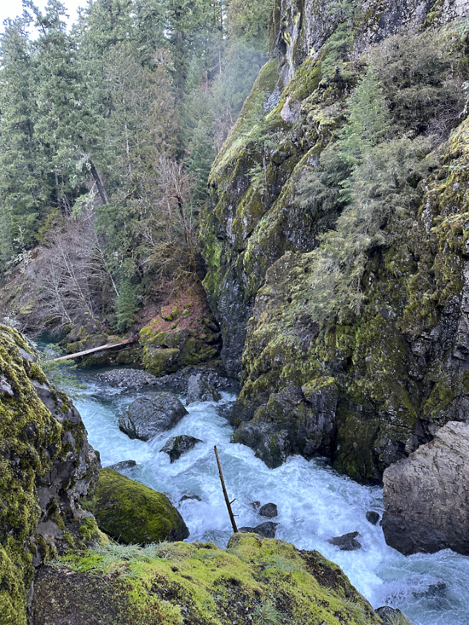
The recently collapsed cliff wall along the Collawash River

We’re experiencing a bit of a geologic moment in WyEast Country, of late. A series of major cliff collapses in recent years along well-known streams has given us a unique opportunity to see the raw forces of nature at work, shaping the landscape in real time, and also to witness nature rebounding after these violent events. Most of these recent collapses have been along streams in the Columbia River Gorge, but sometime over the past two years, the Collawash River joined the trend. 

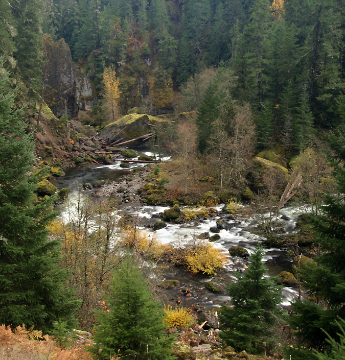
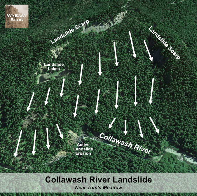
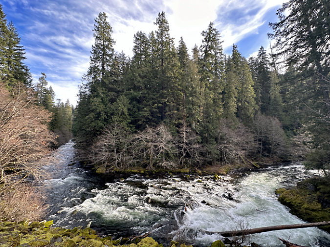
The Collawash River is special. Even in a region known for pristine, spectacular rivers, the Collawash stands apart. That’s in large part due to its unique geology. The Collawash River originates in the remote, rugged Bull of the Woods Wilderness and tumbles through a deep, forested canyon, made perpetually unstable by ancient landslides that are literally pulling the steep mountain slopes on both sides toward the stream.

Massive landslides create a continually changing landscape along the rugged Collawash River

The result is very active landscape along the Collawash, with hundreds of massive boulders marking past landslide events scattered along its course. The ongoing landslides, combined with recent forest fires in the Bull of the Woods Wilderness have also created epic logjams where thousands of trees dropped into the river have accumulated behind these boulders in huge piles.

The erosive action of the Collawash River against the force of these landslides has the effect of a conveyor belt. During high water, the river periodically removes debris from the actively eroding toe of the slides, which in turn, triggers more sliding. This cycle has been playing out for millennia on the Collawash, gradually carrying material from the slides downstream into the Clackamas River, then beyond, leaving only large boulders behind. In time, even the largest of these boulders eventually give way to the elements, and are carried away by the river in pieces.

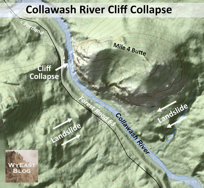
The dramatic, evolving scenery along the Collawash River is shaped by massive, collding landslides pushing into the river canyon from two sides

One of the many landslides feeding into the Collawash River

[click here for a large version]

Along the way, these landslides also push the Collawash River against solid rock walls along its steep course, allowing the river to gradually cut away at these, as well. Like the erosive process described in this recent article, a solid rock wall that has been persistently undercut by the river eventually collapses, adding still more boulders and loose debris to the river. 

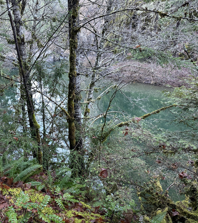
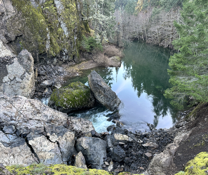
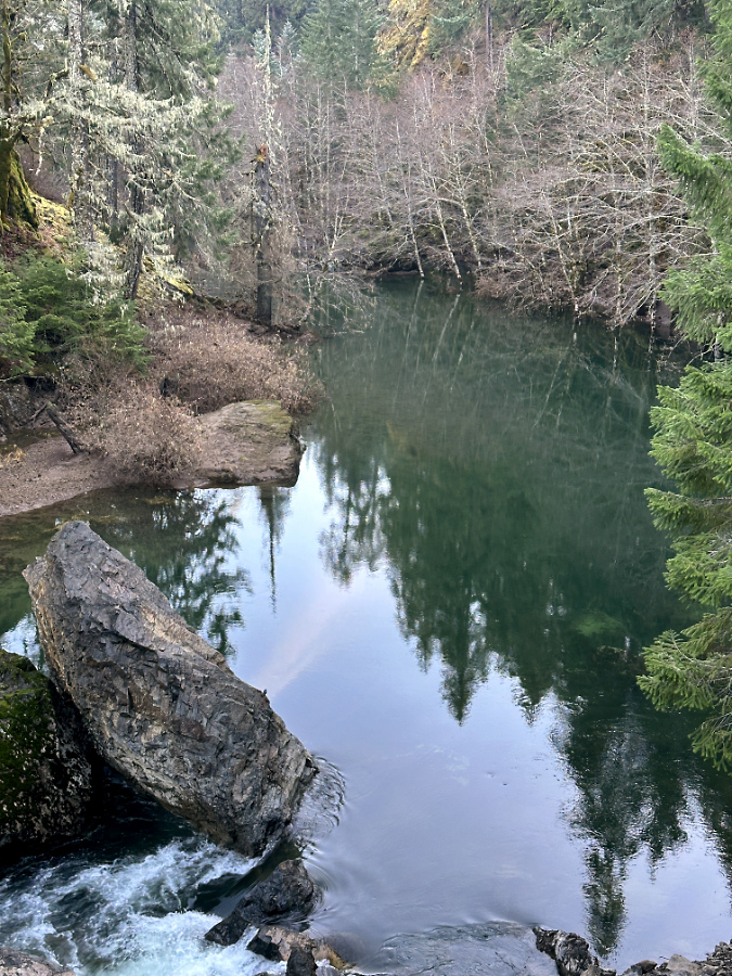
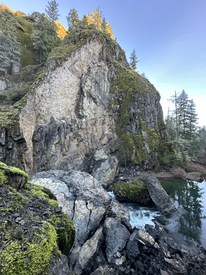
I unexpectedly came across just such an event this year along the Collawash River. The first clue was an eerie slackwater (shown below), with streamside Red Alder inundated under several feet of perfectly still, turquoise water. Just downstream was the answer to this strange anomaly. A massive rock slab had split from a tall cliff along the east bank of the river, crashing into the stream and creating a debris dam that formed a temporary lake on the Collawash.

The eerie, still pool in the Collawash impounded by the recent debris pile

The new debris pile in the foreground and the impounded, temporary lake on the Collawash

The river has since breached the debris pile and is now beginning to carry away fine debris. Note the inundated Red Alder trees in the background

Based on available air photos, the collapse occurred sometime between July 2021 and August 2023 — the 2021 image shows the free-flowing river and the 2023 version clearly shows debris the cliff collapse. While these events can occur at any time of year, those we have seen in recent years have mostly happened during the wet winter months, when the forces of erosion are at their peak. 

Based at the state of the debris pile, I would guess that this cliff came down sometime in the winter 2021-22, roughly two years ago. Why this guess? Because with events like this, the debris pile is usually loose enough for the stream to initially flow under it – like a sieve – until the pile settles and when fine material carried in the stream begins to plug small gaps in the settling pile. The other clue is the lack of fine material on top of the pile – the Collawash has clearly had some time to scour the pile of small debris during at least one season of high water.

(Update: per Ian’s comment, below, the Forest Service estimates the collapse to have occurred in February 2023 — a full year later than my guess! They also reported that at that time, the entire river was flowing through the debris and had not yet overtopped it, where today a significant amount of the flow is overtopping the debris. The Collowash is making quick work of this blockage!)

Though a portion of the river’s flow is now cresting the debris pile, much of the flow is still flowing through the loose debris

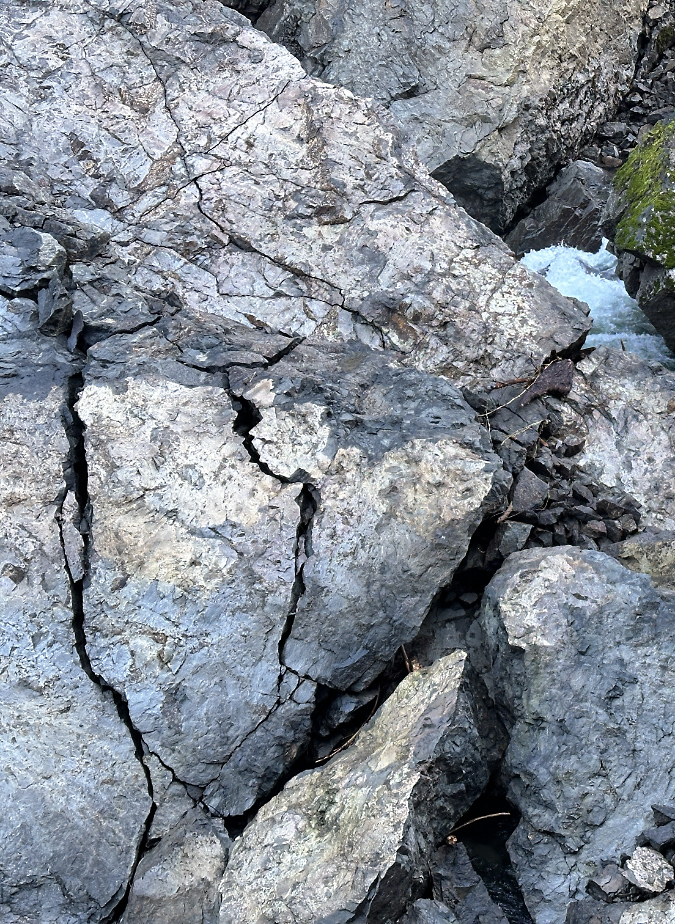
As with other cliff collapses, several very large pieces of intact cliff survived the fall, but these are already beginning to buckle from their own weight. As the stream continues to churn away at the smaller debris in the pile, the huge boulders sitting on top face enormous stress when the underlying debris beneath them shifts. An especially impressive, house-sized slab that is the largest among the boulders to survive the collapse (below) is already showing large stress cracks. It, too, will eventually break apart as the debris pile continues to shift and erode.

The largest of the intact cliff sections is this behemoth, roughly the size of a small house. Stress cracks are already forming as gravity and the shifting, eroding debris flow beneath the boulder continues to move

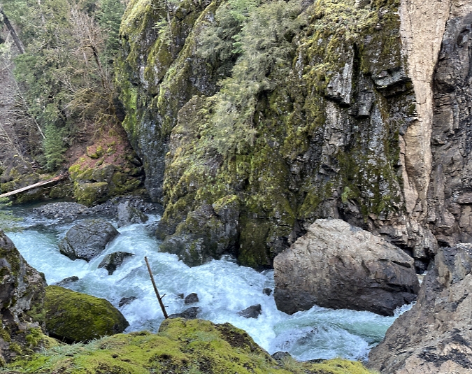
Downstream from the debris pile the Collawash River roars through a new Class 5 rapid created by the debris (below). The erosive energy of this steep, newly-formed rapid is immense. Over time it will erode the debris pile from below, continually pulling material from the collapse downstream and allowing the river to cut more deeply into the remaining pile.

New Class V rapids formed below the debris pile where the Collawash is now much steeper than before

Looking downstream from the collapse section, giant boulders in the distance (now moss-covered) from previous collapses reveal the most recent event as just another in a perpetual process of river erosion here

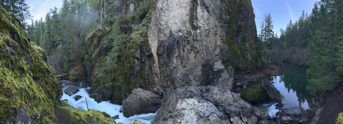
The erosive energy now concentrated in the new rapids just below the debris pile is hydro-physics in action. The panoramic view of the collapse (below) tells the story: the temporary lake on the right hides a series of pools and rapids that existed upstream before the slide, and this energy has now been displaced to the new rapids in the downstream section, just below the slide. 

Panoramic view of the cliff collapse showing the impounded lake (right) upstream and the new rapids (left) downstream created by the debris pile at center

[click here for a large version]

This amount concentrated energy of focused on the lower end of the new, unconsolidated debris pile means the river will quickly win the battle of rock versus water that is on full display here. Eventually, this will become what kayakers call a “boulder garden”, eventually draining the temporary lake and leaving only a few of the largest boulders in place to mark the site of cliff collapse. This is only the latest of many such events at this narrow bend in the Collawash River, and it won’t be the last.

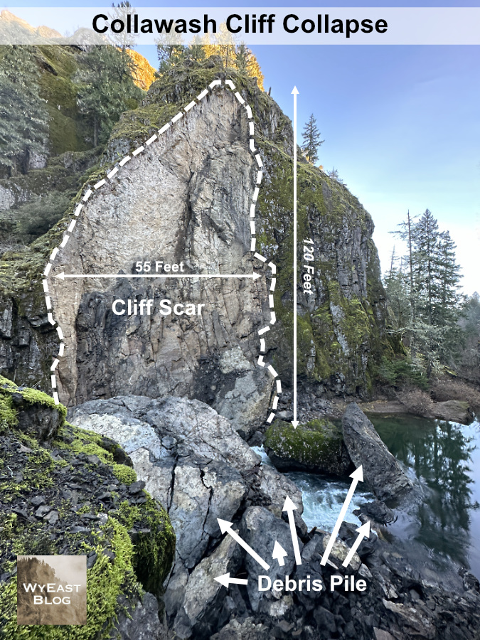
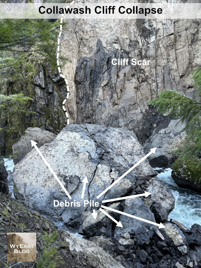
The following schematics show the newly exposed cliff scar and the debris left by the cliff collapse in more detail:

The collapse created a 120-foot vertical scar in the cliff

The debris pile from the collapse is dominated by this massive 25-foot wide boulder

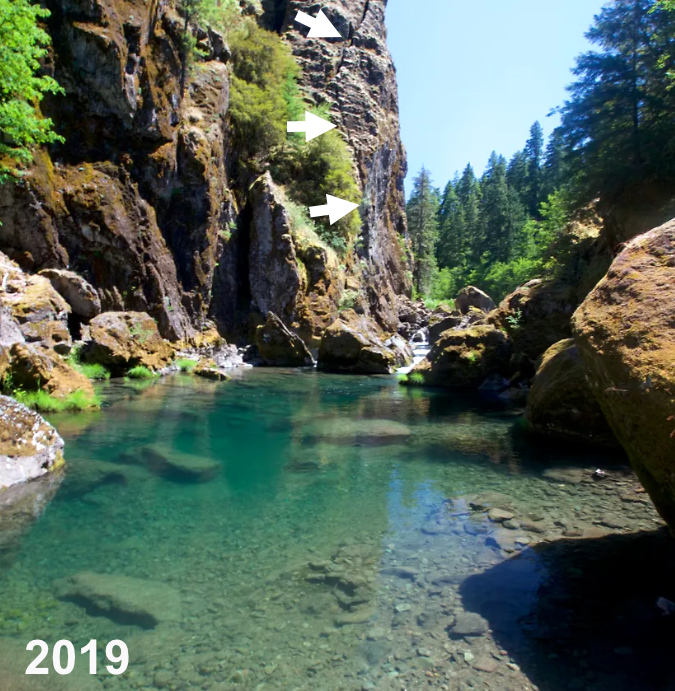
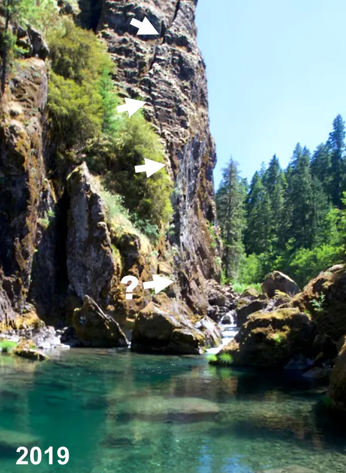
In researching this article, I stumbled across an image captured by outdoor writer Zach Urness in the summer of 2019 at the popular swimming hole just below these cliffs. To my amazement, you can plainly see that a prominent crack had formed in the cliff face, and matches the outline of the eventual collapse! I’ve marked it with a series of arrows in the photo below. 

View of the Collawash River cliff before the collapse with arrows marking the obvious crack that was forming (photo: Zach Urness)

Closer view of the Collawash River cliff before the collapse with arrows marking the crack that would eventually lead to the collapse (photo: Zach Urness)

Zach’s photo also shows how this spot in the stream was already littered with large boulders from prior collapses before the collapse. There’s no way of knowing when these earlier events occurred, but we do know from witnessing the latest collapses here and elsewhere in WyEast Country that they are more common – and constant – than we once thought.

The lack of photos or reporting on the collapse has a silver lining: Zach’s photo was taken from just above the Little Fan Creek picnic area, located at the confluence of the main Collawash and Hot Springs Fork. This area is especially popular with families in the summer months, with crowds of people floating and swimming the many pools in the river, and where a summer event might have had deadly consequences.

How to see it for yourself…

The graceful Collawash River Bridge was constructed in 1957 as part of logging heyday in the upper Clackamas River watershed

The recent cliff collapse on the Collawash River is easy to visit if you’re looking for a weekend drive. The winter off-season is the best time, too, as the Clackamas River corridor is popular and often busy during the spring and summer months. To reach the site, head up the Clackamas River Highway (OR 224) for 26 miles east of the town of Estacada to the Ripplebrook ranger station and campground, Here OR 224 becomes Forest Road 46. Continue for another 3.5 miles on FR 46 to an obvious (but usually unsigned) junction with the paved Collawash River Road (Forest Road 63).

Turn right onto FR 63, and be sure to take your time along this stretch. Here, the road hugs the Collawash River through an exceptionally scenic and geologically interesting areas. You will immediately cross a beautiful arched bridge over the Collawash as you enter the river’s narrow lower canyon on FR 63. Views of dramatic cliffs, river rapids and impressive old growth trees are at every turn, with frequent pullouts for stopping.

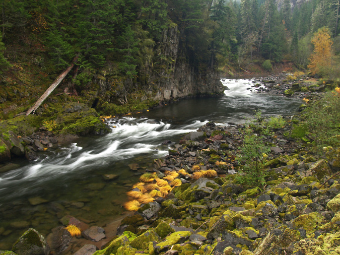
Autumn scene along the Collawash River Road

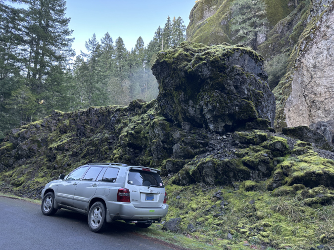
At about the 4-mile mark you will reach another junction, where paved Forest Road 70 heads right to well-known Bagby Hot Springs, located on the Hot Springs Fork of the Collawash River. Stay straight on FR 63 from this junction and immediately cross the Hot Springs Fork on second bridge. The recent cliff collapse is just upstream from here, so watch for an obvious boulder perched on a pile of moss-covered rock on the east side of the road (shown below). This is where the collapse occurred.

There’s room for shoulder parking next to the perched rock, and the best view is from the upstream side of the big boulder, on top of the rock pile. Use care scrambling up the rock pile – there’s a steep drop on the opposite side! 

While it looks poised to roll onto my car, this boulder is from an earlier cliff collapse that occurred well before the Collawash River Road was built in the 1950s. The best viewpoint of the latest collapse is from the top of this rock pile, next to the big boulder

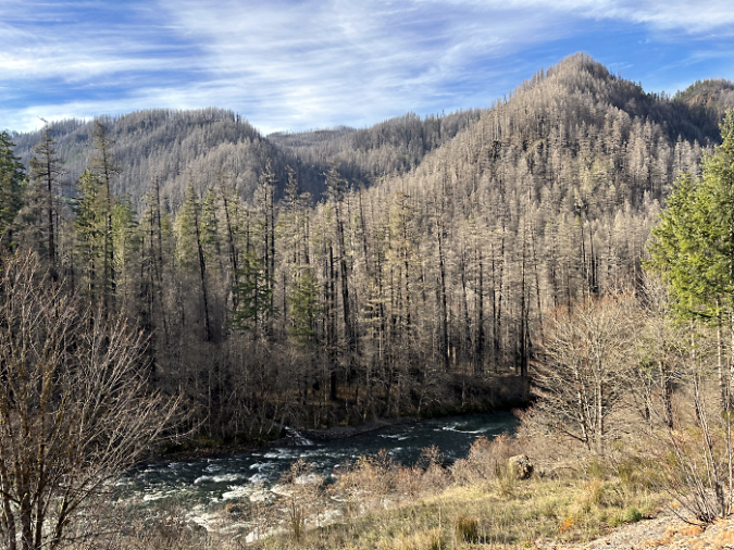
Though the Collawash River was mostly spared by the Riverside Fire that swept across 138,000 acres in the Clackamas River watershed in 2020, the Clackamas River Highway route to the Collawash River travels through much of the burn. While this might sound a bit bleak for a scenic drive, it’s a great opportunity to fully appreciate the scope of the burn and watch the beginnings of the post-fire forest recovery here. 

The Riverside Fire was the third and largest of three human-caused fires to sweep through the Clackamas River canyon over the past two decades. While fires are a natural and necessary element to forest health in the Pacific Northwest, it’s also true that human-caused fires are burning the Clackamas River basin (and many other forests in the Pacific Northwest) at an unsustainable. 

The human-caused Riverside Fire roared across the Clackamas River area in September 2020 burning 138,000 homes and dozens of structures in its path

Human-caused fires are also killing old-growth riparian trees that have survived centuries of wildfires. Why? In part because of the intensity of these recent burns as a result of decades of fire suppression, but also because riparian areas were often be spared in the past by natural, lightning-sparked fires that typically began on exposed, drought-stressed ridgetop forests – not in moist rainforest canyons, where all three of the human-caused fires on the Clackamas started.

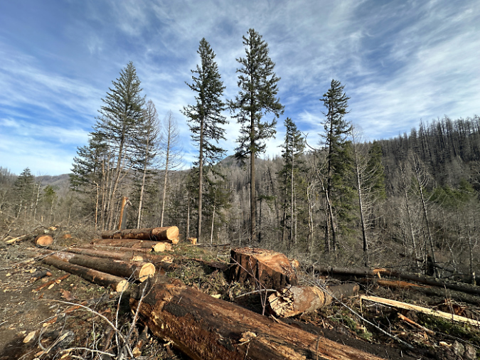
The Forest Service is still gradually reopening the many campgrounds and picnic areas along the Clackamas River that were affected by the burn, so you are likely to encounter logging operations where trees deemed “hazardous” are being removed by contract crews. These projects are well-signed and easy to avoid if you’re following the main route.

The Forest Service is still logging fire-killed or weakened trees like these along major forest roads in the Clackamas area as “hazard trees”

For a longer tour, you can continue further upstream along the Clackamas River Highway from the Coillawash River Road junction. The highway hugs the Clackamas River for another eight scenic miles, with pullouts along the way to appreciate the views. This section of the highway passes Austin Hot Springs, an interesting area, but also a private inholding within the national forest, and not open to the public.

Above the Collawash River confluence, the main Clackamas River is unburned and a reminder of what the lower canyon looked like before the 2020 Riverside Fire

As you explore the area, you may begin see each vertical cliff and outcrop with new eyes as – perhaps – the next real-time geologic event! Chances are slim that any of us will witness such an event, but seeing the aftermath of the Collawash River collapse gives a new appreciation for the constant natural processes that continue to shape the scenery around us.

Enjoy!

_______________ 

Tom Kloster | January 2024
The Hidden Shame of Latourell

Since tourists first began exploring Samuel Lancaster’s graceful new Columbia River Highway in 1915, Latourell Falls has been a favorite stop. In the early days, a pair of roadhouses (the Falls Chalet and the Falls Villa) flanked the highway at the east end of the dramatic highway bridge spanning the creek, and offered lunch with a view of the falls.

Today, the falls are the main focus of Guy Talbot State Park, with thousands of visitors each year exploring the series of loop trails that circle the lower falls and follow Latourell Creek to the upper falls.

The Falls Chalet in 1915

The scenes along Latourell Creek are beautiful and iconic, and most visitors simply accept that this place will be protected forever for the public. Yet, experienced hikers notice something different about this western-most of the waterfall trails in the Columbia Gorge: it’s not pristine, at least not in the way that other streams in the Gorge are. Despite the beautiful setting, big trees, wildflowers and waterfalls, something about this stream seems degraded.

When crossing the rustic footbridge at the thundering base of Latourell Falls, there is often a distinct odor of algae in the air. A closer look at the stream reveals not only algae on the rocks, but also crusty mineral deposits that also suggest degraded water quality in this beautiful stream, and would help explain the algae blooms.

This close-up view (below) is a detailed look at the lower right corner of the previous image of Latourell Falls. The close-up view reveals white mineral deposits and yellow-grown algae stains on several boulders and cobbles. This view also shows fine silt deposits (brown areas in the lower right) that suggest some sort of major disturbance in the watershed.

Why is this? What’s behind the water quality problems on this otherwise untouched stream?

Going to the Source

Upstream from the waterfalls and throngs of visitors along the lower canyon section of Latourell Creek, an explanation for the degraded water quality is revealed. Though few visitors to the lower reaches of the stream would imagine it, the headwaters of Latourell Creek are privately owned, with a number of homes and a lot of logging along the stream.

Amazingly, more than three quarters of the Latourell Creek watershed lies outside the protection of public parks and the Columbia River Gorge National Scenic Area (CRGNSA).

While the private homes are partly responsible for the nutrients that feed algae and leave mineral deposits in Latourell Creek (from lawn chemicals, septic tanks and other sources), the aggressive logging of private lands in the upper watershed is the greatest risk to stream quality.

The environmental impact of logging in the headwaters is painfully obvious, with canyon slopes recklessly harvested in clearcuts. This is a discredited, outmoded form of timber management that shouldn’t be practiced anywhere, much less a stream of this caliber that flows into a National Scenic Area.

The clearcut photos shown here were taken in the summer of 2010, with most of these harvests just a couple of years old. In this view (below), an older clear cut can also be seen on the hillside across the canyon, and is just beginning to recover with a light green layer of growth. Most of these forests have been cut several times, with ever-shortened growth cycles between harvests, thanks to a growing market value for marginal timber.

In this view (below) raw skid roads in the lower right drain directly into Latourell Creek, which flows along the tree line, at the edge of the clearcut. Erosion from bare slopes and logging roads is responsible for the most fine sediments (mud) seen below, in the protected sections of Latourell Creek. These sediments not only spoil the stream bottom, they also introduce minerals at a rate which promotes the growth of algae, which in turn, can also harm stream health.

Sadly, Oregon law continues to allow timber harvesting using the clearcut method, and the few environmental protections that do exist for stream protection on private timberlands are little compensation for the effects of clear cutting.

The tragic reality is that in Oregon, the timber lobby is still king. Twenty years of non-stop public relations advertising (kicked off during the early 90s Spotted Owl crisis) by Big Timber have been surprisingly effective in keeping the public largely misinformed on what is really happening in private forests.

In this view (below) of upper Latourell Creek, the private property owner has left the minimal amount of riparian “buffer” required by Oregon law. The trees in this photo are less than ten feet from the edge of Latourell Creek, and most of what you see is actually growing on the opposite bank from the clearcut. Clearly, this practice threatens severe erosion and sediments from the logged area entering the stream in a region where rainfall amounts can reach 100 inches annually.

Clearcuts threaten more than steams and water quality, however. In the 1990s, the Oregon timber lobby was forced to accept limits on clearcutting above roads and dwellings because of a number of catastrophic slides that had been triggered around the state by the practice.

Yet, few limits on logging below developed roads exist, and in the case of the upper Latourell canyon clearcuts, the impact of logging on the slopes below the local roadways is real. In the following view, large trees have not only been recklessly cut from the slope below the road, but the remaining smaller trees and shrubs have been sprayed with herbicide — a routine treatment after clearcutting — and thus killing what was left of root systems that help hold the slope together. As the image indicates, there are already active slides along this slope, triggering road repair costs that will fall upon the public to fix, not the private land owner.

This photo (below) shows the slide repair in more detail — a 200-foot section of road that has already been filled and patched repeatedly, and now will likely continue to fail thanks to a slope that has been further destabilized by aggressive logging.

What’s the Solution?

For much of Oregon, the fate of clearcutting is an open question, with the timber lobby thus far successful in its efforts to prevent the practice from being outlawed. That’s a shame, and a sad commentary on our state politics. But in the case of Latourell Creek, there’s another option.

When the authors of the Columbia River National Scenic Area (CRNSA) were drawing up maps, they focused on scenery and what could be seen from points along the Columbia River. As a result, the scenic act ignored a crucial lesson learned from the newer national parks of the 1960s — most notoriously, Redwoods National Park — that when acquiring park lands, complete ecosystems and watersheds should define the boundaries.

A look at the CRNSA boundary in the Latourell Creek headwaters shows the problem: the upper watershed falls outside the scenic area, and thus is excluded as a place for meaningful regulation or public land acquisition.

Click here for a larger map

It doesn’t have to be this way, however. These lands should be added to the CRNSA, and managed holistically, with the health of the spectacular lower canyon in mind.

After all, Latourell Creek is the only major stream on the Oregon side of the Gorge to straddle the boundary, and thus a good case can be made for amending the CRNSA boundary to incorporate the complete watershed. This would allow for better regulation of private lands in the headwaters, at a minimum, and also allow for CRNSA land acquisition funds to be used here.

Upper Latourell Falls

Another argument in favor of expanding the CRNSA boundary is the convenience of Larch Mountain Road in defining the Latourell Creek watershed. This popular recreation route is already viewed as “part” of the scenic area, albeit outside the boundary in this section. Therefore, an expanded boundary would allow the full Larch Mountain Road corridor to be managed as an extension of the scenic area. This extent is reflected on the map, above.

What Would it Take?

Amending the CRNSA requires an act of Congress, and though it sounds daunting, minor changes to federal boundaries of this sort are common as “riders” on larger federal lands bills.

While better regulation of private lands in the upper Latourell watershed would surely come from an expanded CRNSA, the chief benefit would be the ability to acquire lands for restoration. Already, the Forest Service has acquired hundreds of acres of private elsewhere in the Gorge, and the upper reaches of Latourell Creek would be best protected by fully restoring the watershed.

Upper Latourell Falls

Yet another option could be for advocacy organizations — like the Friends of the Columbia Gorge or Trust for Public Lands — to acquire the upper watershed lands. However, these groups generally operate inside the existing CRNSA boundary, and focus limited funds on still-pristine lands or those with exceptional scenic value.

In the end, it seems that our best bet is for the Oregon Congressional delegation to consider a “housekeeping” update to the CRNSA, including boundary refinements. Perhaps a 20-year review of the CRNSA is in order in 2016?

Restoring forests, one community at a time

Interior Secretary Ken Salazar set the Pacific Northwest forest recovery effort back on track in July when he reversed the Bureau of Land Management’s (BLM) Western Oregon Plan Revisions (the WOPR, a brilliantly unintentional blunder as acronyms go, as it became known as “The Whopper”). This represented a major step back from scientifically corrupt policies intended to enrich timber corporations at great cost to our public lands.

In this recent opinion piece in The Oregonian, Dominick DellaSala and Randi Spivak respond to Salazar’s move, and provide an excellent framework for how we should move forward to restore our public forests. Their prescription: emphasize needed thinning of the sickly, biologically sterile tree plantations left from the logging heyday of past decades, and embrace the value that our restored forests will have in the global effort to reduce carbon emissions.

The eastside forests spreading out below Lookout Mountain look healthy enough from a distance, but in reality are in dire need of a bold new restoration strategy.

The eastside forests spreading out below Lookout Mountain look healthy enough from a distance, but in reality are in dire need of a bold new restoration strategy.

As described in their article, the Siuslaw National Forest has already begun to embrace this new approach, and other public forest managers are beginning to take notice. But a truly comprehensive restoration effort must be more aggressive, and should also focus on stabilizing the forest-based communities that were left to die when the big timber operations pulled out in the 1980s and 90s

Traditional thinning offers a couple of opportunities for local communities: the timber operations involve most of the same logging skills that were once the mainstay of rural Oregon. In addition, the harvested wood from thinning offers not only traditional saw logs for small mills, but also a new economic niche in the smaller woody debris that was once discarded or burned on site in the forests. New uses for small woody debris include engineered wood products and even energy production as biomass.

A closer view of typical second-growth forests near Lookout Mountain reveals a dying, overcrowded ecosystem under great biological stress.

A closer view of typical second-growth forests near Lookout Mountain reveals a dying, overcrowded ecosystem under great biological stress.

One practical challenge in reaching this new approach will be the scaled-back network of logging roads, since the over-built system constructed in the second half of the 1900s is rapidly crumbling and infeasible to maintain for the long term. One strategy is to tie road decommissioning to forest thinning and restoration efforts, pulling out obsolete roads after forests have been largely restored. Another could be aerial operations, perhaps even balloon logging. Still another could be roadless logging with light equipment or even horses — a practice well established on small, private woodlots in Oregon.

The key to finding this new balance in sustainable forest restoration a role of direct stewardship among the forest communities — to view them as the keepers of the forest, as opposed to the “forest dependent” mindset of the industrial logging era. This means establishing an ongoing relationship between community-based forest management organizations and the federal agencies that govern most of our public forest land. These new organizations could follow the lead of watershed councils and farm bureaus, using formal governance coupled with direct management responsibilities as forest recovery agents.

A bright spot in the restoration of the eastside forests near lookout mountain, this thinned plantation is beginning to resemble a natural forest, with multi-aged stands and a recovering understory.

A bright spot in the restoration of the eastside forests near lookout mountain, this thinned plantation is beginning to resemble a natural forest, with multi-aged stands and a recovering understory.

How would the economics of community-based stewardship work? In a commodity-based model of selling products recovered from thinning, the objective is straightforward — but unlikely to be profitable as a private enterprise.

Instead, the public will likely need to provide some level of subsidy for the restoration work involved, with commodity proceeds offsetting public costs. The advantage of a public subsidy is that it provides an ongoing public interest in the health and viability of the forest communities, themselves, and could help avoid the volatility that private timber harvesting brought to these communities in their first century.

A few stands of late succession ponderosa and Western larch forest still exist on the slopes of Lookout Mountain, providing a glimpse of what a restoration policy must aim for.

A few stands of late succession ponderosa and Western larch forest still exist on the slopes of Lookout Mountain, providing a glimpse of what a restoration policy must aim for.

But the more interesting idea is to create a long-term financial model for stewardship communities based on carbon sequestration as part of global efforts to reduce carbon emissions. Carbon credits would be sold as offsets to carbon polluters, and providing a permanent incentive to bring the northwest forests back to health.

The credits could be managed as a community trust, or managed through a public-private corporation. Under this paradigm, there would be little incentive to harvest large trees, since they would exist primarily as carbon storage units under the new carbon-based economic framework.

Of course, we also know that big trees and mature forests also provide a much wider array of ecological and social benefits, but these costs have never factored in to the short-term price for raw logs in the old timber harvesting paradigm. As DellaSala and Spivak point out in their article, the Pacific Northwest is uniquely capable of storing carbon in our living forests, and to a degree nearly unmatched in the world. If this potential is given a value, then we may well seen an end to the destruction of our mature forests for saw logs and pulp that could just as easily be manufactured from private plantation materials.

The concept of community-based stewardship in carrying out forest restoration is attainable, as evidenced by the many successful public-private partnerships that exist today. But it’s unclear if the Forest Service and BLM bureaucracies are flexible or willing enough to embrace the idea.

Instead, a new conservation-based form of administration may be needed — broader than the National Park Service in scope, but borrowing from the Park Service ethic of conservation and sustainability. The Cascade Forest Preserve, perhaps, extending from the Sierras to the Canadian border? Given the grave implications of climate change, it is impossible to think too big or boldly as we search for a way forward.

Fire Forests of the Cascades

The Gnarl Fire of 2008 shocked Portlanders by racing across the east slopes of Mount Hood, and nearly destroying the historic buildings at Cloud Cap and Tilly Jane. But as an east side fire, the Gnarl burn was relatively small, and part of what has become an annual ritual for rural communities of fighting intense blazes along the east slope of the Cascades.

The 2008 Gnarl Fire, viewed in August from Dufur Mill Road

The 2008 Gnarl Fire, viewed in August from Dufur Mill Road

The cause for the intensity of these fires is well-known and well-documented. We know that a century of fire suppression, promotion of even-aged stands of second growth in logged areas and a changing climate are forces conspiring to burn the east side forests on a scale not seen in recent decades.

But not all of the east side fires are catastrophic, even with the fuel build-up from our history of fire suppression. The 2006 fire at Bluegrass Ridge was a glimpse into what was once a routine occurrence along the east side of the Cascades. The Bluegrass Fire began as a lightning strike in the dry season, and soon spread along the east face of the ridge in a mosaic pattern: some parts of the forest were completely killed, while others were a mix, where pockets of forest survived among the burned trees.

The aftermath of the 2006 Bluegrass Fire ranged from total destruction in areas like this, to mosaic patterns where less crowded forests existed

The aftermath of the 2006 Bluegrass Fire ranged from total destruction in areas like this, to mosaic patterns where less crowded forests existed

Most significantly, the larger, fire-resistant species like western larch and ponderosa pine often survive fires in these mosaic areas, and this was the case in the Bluegrass Fire. We will know in a year or two whether the extensive larch population in the Gnarl Fire area were similarly resistant.

The survival of these big trees is the key to the natural ecosystem that defines east side forests. Forest ecologists are now calling these east side regimes “fire forests”, as a counterpoint to the west side rain forests, where abundant rainfall is the operative element in defining the forests.

The “fire forest” name is apt, since we now know that a number of tree species in this dry forest system depend on fire for natural succession that creates mature forests. In the Mount Hood area, these east side trees are Douglas fir, western larch and ponderosa pine. All three have thick, fire-resistant bark that helps them survive moderate fires, and benefit from periodic clearing of undergrowth that competes for moisture and soil nutrients. Fires, in turn, release nutrients for the big trees, further enhancing the growth of fire-resistant species.

Western larch light up the eastside forests in autumn. Larch are among the fire-resistant species that require periodic burns for their long-term health

Western larch light up the eastside forests in autumn. Larch are among the fire-resistant species that require periodic burns for their long-term health

The question for the east side forest is not whether they will continue to burn — they have evolved with fire, after all — but rather, how we will learn to live with the fires. We now know that we cannot simply extinguish them. A century of fire suppression has created mammoth fires that we simply cannot control.

We also know that we cannot prevent forest fires from starting, since the large majority begin from lighting strikes. And we know that many more catastrophic burns will occur before the east side forests return to a more sustainable condition that mimics the natural ecosystem that once thrived.

Most ominous is the recent discovery — from tree-ring research — that the Western states are coming off an unusually wet century, and that the decades ahead are likely to carry more drought, not less. So it is imperative to help the east side forests stabilize before conditions make that proposition still more difficult.

These mature, healthy forests of western larch, ponderosa pine and Douglas fir along Bluegrass Ridge survived the fire

These mature, healthy forests of western larch, ponderosa pine and Douglas fir along Bluegrass Ridge survived the fire

A first step is continuing to thin tree plantations on logged lands to help prevent still more crowded, bug-infested forests like those that are currently driving the fire epidemic. The second step is more difficult: letting fires burn. This policy will be most difficult in the many areas where rural development has encroached on forest boundaries, but it is a necessary step. Both of these steps will require a new mindset about fire, not the least of which will be a public education shift away from Smokey Bear and fire suppression and toward a modern understanding of fire.

But a third step is most difficult of all: setting fires in prescribed locations to help restore forest balance. While the rash of east side fires in recent years has made this part of restoring forest balance less urgent, it will still be necessary — and controversial. Federal agencies have already begun employing this tool, but in cases where a controlled burn becomes a wildfire, the public is not prepared to understand why that risk is necessary — and perfectly natural. Still more public outreach and education will be needed.

The good news is that the scientists are winning this debate, and even the Forest Service has gradually begun to embrace fire ecology as part of their management philosophy. The Park Service is much further long, having successfully weathered the early criticism of their prescient decision to let the huge Yellowstone fires of the mid-1980s burn.

The remarkable resilience and recovery of Yellowstone in the intervening years has not only been vindication for that bold decision, but also an invaluable lesson to land agencies across the west who are responsible for managing “fire forests”. The time to embrace fires in our forests has arrived.

Boundary Clear Cut – Part One

Looking west across the devastation zone of the Boundary clear cut, where the forest was cut to the wilderness boundary, and across lakes and canyons that stood in the way

Looking west across the devastation zone of the Boundary clear cut, where the forest was cut to the wilderness boundary, and across lakes and canyons that stood in the way

Among the more grotesque of the thousands of clear cuts that sprawl across the Mount Hood National Forest is a nearly 800-acre complex along the west shoulder of Vista Ridge called the Boundary clear cut.

The Boundary cut is remarkable in that it quite literally defines the boundary of the Mount Hood Wilderness for nearly two miles, following an painfully straight line right over the lakes, streams and canyons that stood in its way.

The surgical precision of following such an arbitrary slice across the terrain betrays an astonishing degree of defiance and disregard for the management directive that comes with wilderness designations. The Forest Service planners who sold this timber in the late 1980s and early 90s were clearly carving off whatever could be rationalized under the narrowest interpretation of environmental law — if this was a lawful timber sale, at all. After all, how could cutting a pristine forest to the edge of wilderness have anything but a harmful effect on the adjacent wilderness value?

This GoogleEarth rendering shows the appalling proximity of the Boundary clear cut to Mount Hood's most pristine backcountry

This GoogleEarth rendering shows the appalling proximity of the Boundary clear cut to Mount Hood's most pristine backcountry

The price of this recklessness is substantial. The impact to the forest and watershed are the subject of this two-part article. This part focuses on the broken mindset that led to the devastation, and how it illustrates a fundamental flaw in the U.S. Forest Service mission: that this agency is simultaneously tasked with both protecting and exploiting the resources under its management.

The first flaw in agency mindset that led to this environmental tragedy is the notion that high-elevations forest can be farmed like so many rows of corn. At an elevation of 4,800 feet, the forest here consists almost entirely of slow-growing noble fir. In this zone, “sustainable” logging becomes tree mining, as it will be decades before these forests recover, and centuries before they regain their former stature as a mature ecosystem.

Noble fir are slow growing giants of our high-elevation forests; this fallen noble measures just over a foot in diameter, yet is more than 170 years old

Noble fir are slow growing giants of our high-elevation forests; this fallen noble measures just over a foot in diameter, yet is more than 170 years old

Consider the fallen noble fir pictured at left, found on a nearby hiking trail. Though measuring just over a foot in diameter, this tree is 170 years old. This should come as no surprise, given that nobles live in a zone that sees a winter snowpack of 6-12 feet in winter, and as few as four or five months when snow doesn’t cover the ground.

The second flaw in the Forest Service mindset is the notion that clear cuts and the associated network of logging roads are sustainable by any measure. Neither are, and only now has the agency begun to acknowledge this fundamental reality — more than three decades after the scientific community had debunked both practices as part of sound forest management.

Today, the tangle of deteriorating roads in the Boundary clearcut are gradually being decommissioned at taxpayer expense, to prevent further degradation of water supplies and fish habitat, and to discourage lawless behavior from off-highway thrill-riders.

The third flaw in Forest Service thinking that allowed the Boundary clear cut to happen is the assumption that timber harvest trumps all, and that steering the public away from logging operations somehow mitigates the lost recreational and scenic resources. Indeed, most trails that once threaded through the surrounding Vista Ridge area were dropped from Mount Hood National Forest maps in the 1950s and 60s, in preparation for the coming storm of industrial logging.

We now know that the logging heyday on our Forest Service lands was heavily subsidized by taxpayers, so the sight of piles of rotting logs left scattered across the Boundary clear cut only underscores the reckless, wasteful manner in which our forests were plundered

We now know that the logging heyday on our Forest Service lands was heavily subsidized by taxpayers, so the sight of piles of rotting logs left scattered across the Boundary clear cut only underscores the reckless, wasteful manner in which our forests were plundered

Sadly, this area held some of the most scenic spots found on the mountain, but the value of saw timber here trumped recreation in the Forest Service math, as was the case in much of the Mount Hood National Forest. The good news is that volunteers have recently re-opened one such trail on Vista Ridge (see the Portland Hikers Field Guide trip to Owl Point) There are also opportunities to reconnect some of the old, lost routes destroyed by logging by simply ducking inside the wilderness boundary, where the forests are still pristine and scenic.

It’s tempting to believe that the U.S. Forest Service can be reformed, and actually carry forward the restoration work needed to undo the damage that we see in places like the Boundary Clear Cut. This has been the agency message in recent years, and many well-meaning employees within the agency are working to change its course.

But the reality is that the Forest Service mission forever exposes the agency to the same political and economic winds that left us with the current logging aftermath. Only by moving Mount Hood’s battered lands into National Park Service stewardship can true restoration — and future protection from similar abuses — be truly guaranteed.

Just 75 Years

Autumn unfolds along McGee Creek, in the upper West Fork Hood River valley

Autumn unfolds along McGee Creek, in the upper West Fork valley

This scene in the headwaters of the West Fork of the Hood River was captured a few weeks ago, as early autumn colors began to sweep through the forest. This particular stream is McGee Creek, one of the larger tributaries that feeds the West Fork. Most hikers know McGee Creek from its alpine origins, where it tumbles from the wildflower meadows that sprawl below popular McNeil Point. But the creek soon enters lush forest on its way to joining the West Fork.

The surprise is that none of this existed just 75 years ago, when massive railroad logging operations had leveled the virgin forests of the West Fork. Look closely at the following image, captured in 1933 from high above the West Fork valley; the methodical clearing of the forests on the valley floor is nearly complete, and the steam plume from a log train headed back to the old mill town of Dee can also be seen:

By 1933, railroad logging had nearly cleared the West Fork valley

The steam engine in this old photo is at roughly the same spot as the autumn scene in the upper photo, illustrating the remarkable resilience of our forests. In about the span of an average lifetime — just 75 years — the forest along this stretch of McGee Creek has recovered from complete destruction, largely on its own. This is good news for other areas of Mount Hood and the Gorge that still show the scars of logging and road building. Given time and some modest restoration efforts, even the most damaged ecosystems will recover.

The autumn scene on McGee Creek also holds some lessons for restoration that may not be immediately obvious. The large log lying along the right side of the creek, for example, was carefully placed there by biologists, just a few years ago. This was in recognition that a century of logging has deprived our streams of large woody debris that turns out to be an essential ingredient for healthy fisheries.

Perhaps most importantly, the white-trunked alders that line McGee Creek show that the forest here is recovering through natural succession. These pioneering trees provide quick cover and their dense root systems help prevent soil erosion.

Red alders are short-lived, adding their fallen debris to the rich duff layer they help build in recovering areas. Amazingly, they actually fix nitrogen in the soil through their roots, enriching it for the big conifers that will follow. Finally, the light canopy they provide allows for a complex understory of plants to develop in tandem with the alder groves, ensuring that forest diversity is re-established during the recovery cycle.

A typical red alder grove pioneering the recovery along an old road

A typical red alder grove pioneering the recovery along an old road

When McGee Creek was logged, the natural recovery that followed was mostly accidental — early timber operations viewed the forests as limitless, and logged areas were mostly ignored once the trees had been cut. The shift to cultivated tree farms didn’t begin until the late 1940s and the era of road-based logging.

In these more recently logged areas, the pioneer, non-commercial hardwoods like red alder were usually killed with herbicides in order to promote the quick growth of commercial timber species, especially Douglas fir. This practice has led to the thickets of crowded fir trees that we see today. These unnatural stands are vulnerable to disease and fire, and have almost no understory to provide for bio-diversity and wildlife habitat.

Sadly, it will take decades to thin these misguided plantations and decommission the failing logging roads that threaten streams and slopes. But though the task of forest recovery and restoration is a tall one, the good news is that the lessons of natural succession from places like McGee Creek have worked their way into forest management. Our scientists are now learning to work with nature, not control it — by letting the red alders grow.

As we continue to turn the page on past practices and begin a new era of restoration for the forests of Mount Hood, we can take some degree of consolation in knowing that a complete recovery is well within our reach. By watching and learning from the forest ecosystem, we now realize that the natural processes that have renewed our forests for millennia must be allowed to follow their ancient course, once again.