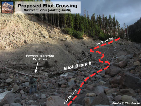
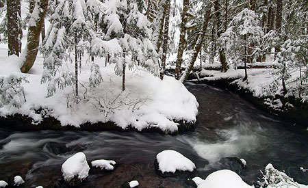
20 years of change on Cooper Spur… and the future?

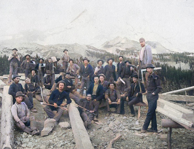
Workers cutting beams from solid pine trunks for the new Cloud Cap Inn during the summer of 1888. The (then) surging Eliot glacier loomed just beyond Cloud Cap in those early days (Author’s note: this is a modified historical image that I have colorized to bring the sense of the distant past a bit closer to our present-day world)

[click here for a large version]

When the builders of Cloud Cap Inn began construction in earnest in early summer 1889, the backdrop for Mount Hood’s first mountain lodge was radically different than today. The Northern Hemisphere was experiencing the final decades of a brief, still unexplained cooling period known as the Little Ice Age that stretched from the 1500s through the 1800s. 

The cooling was modest, but enough to surge the Eliot Glacier down to the tree line, nearly filling the deep trough between the high lateral moraines that were created in the last true ice age, thousands of years prior. The debris-covered terminus (or snout) of the Eliot Glacier was in plain view from Cloud Cap, directly behind the workers on the left side of the photo, above. It was formidable wall of glacial ice and rock rising nearly 300 feet above the valley floor.

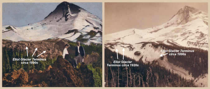
Early photo views of the Eliot Glacier’s terminus shows the river of ice already receding between the 1890s and 1920s

[click here for a large version]

The Little Ice Age faded in the 20th Century, and as the photo pair above shows, the Eliot Glacier was already receding from its recent surge by the 1920s. Today, the Eliot Glacier has retreated about a half mile from its terminus in 1889, and lost as much as half its depth to our warming climate. 

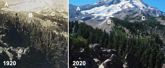
The following photo pair shows the dramatic change from 1920 to 2020. The change in the glacier’s thickness can be seen by (A) the exposed cliffs below Cooper Spur were carved into a vertical wall by the glacier at its peak. The glacier’s terminus (B) has receded dramatically over the past century, revealing the high moraines we now see rising above the Eliot Branch. A more subtle change (C) are the alpine forests gradually moving up the mountain as summer snowpacks diminish.

Another, more detailed 1920 view of the Eliot Glacier’s terminus compared to the same view in 2020 shows the radical change over the past century

[click here for a large version]

For much of the past century, these changes were gradual enough that only a few scientists and mountain climbers noticed the ongoing change. But since the turn of the millennium the pace of change has accelerated to an alarming rate as our climate warms.

This article documents this most recent period of change, over the two decades that span from 2002 to 2022, including how the landscape on the mountain, itself, as changed. The article focuses on the area around Cloud Cap and the Eliot Glacier, as viewed from the Cooper Spur trail, as this corner of the mountain has seen some of the most volatile change.

Why 2002 as a starting point? That answer has to do with technology, not climate change. That was the year that I began shooting with a digital camera. For someone who learned photography with a film camera (including plenty of spent time in the darkroom in the 1980s) the age of digital has been a revelation. Film and print paper was expensive, and while I have a lengthy archive of images going back to 1980, the digital era has allowed me to bring back hundreds of photos from a single trip to the mountain, where I might have captured a dozen during the film era that was rapidly winding down by the early 2000s. 

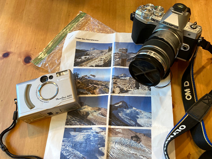
Then and now – my 2002 pocket camera and 2022 digital SLR, along with the 2002 photos I hoped to re-create.

The result is enough archived images beginning in 2022 to create a fairly thorough then-and-now comparison of the Eliot Glacier and surrounding environment along the Cooper Spur trail. The 2002 images came from a Canon A50 PowerShot pocket camera, still one of the best digital cameras I’ve owned over the years. Not long after this trip in 2002, I added my first digital SLR to my camera collection, and I have long since retired my film cameras for good. The 2020 images were captured with an Olympus EM-10 digital SLR, my fifth digital SLR, and easily my favorite (thus far).

To re-create the images from that 2002 trip, I carried a folded-up, modern-day version of a film-era proof sheet from that earlier visit in my pocket on a hike up Cooper Spur last September. Along the way, I did my best to match the scenes as I had viewed them 20 years prior. Once home, I was able to assemble 19 pairs that were close though to allow for nearly identical side-by-side comparisons. I’ve also noted a few points of interest for each image, keyed to both the 2002 and 2022 versions, to help highlight the changes that have unfolded. Because the embedded images in this article are inherently small, I’ve also posted a link below each image to a large version that will open in a new tab.

And now, how about a tour of these places in 2002 and 2022?

Change is constant… and surprising!

[click here for a large version]

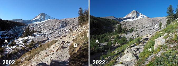
From Cloud Cap, the Timberline Trail route to Cooper Spur makes a dramatic entrance to the upper section of Tilly Jane Canyon and the first big view of Mount Hood. The changes in the first photo pair (above) are subtle, though telling. As is the case throughout the Cascades, groves of (A) Mountain hemlock continue their march to higher elevations, one more indicator of our changing climate. Lighter snowpacks (which translates to longer growing seasons) might also be the explanation for more expansive groundcover (B) of Juniper and Penstemon in the foreground. In distance (C), a pioneering Whitepark pine has survived to grow from a few feet tall to nearly 20 feet.

[click here for a large version]

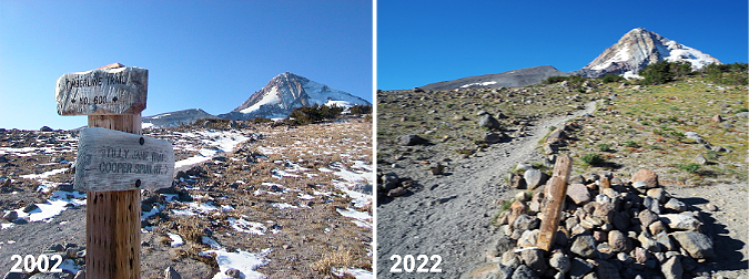
Moving further up the mountain, the Timberline Trail reaches a junction with the Tilly Jane and Cooper Spur trails (above), just above the tree line. Here, the most notable change is the battering the old trail sign has taken in 20 years of winter storms and avalanches.  The two signboards were still around as recently as four years ago, but they were finally swept away in the last couple years. The bottom of the 8×8” post remains, though it had snapped off mid-way several years ago — a reminder of the power of moving winter snow in this avalanche-prone area! 

[click here for a large version]

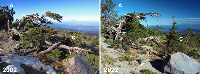
Just uphill from the trail junction, the next photo pair (above) shows a venerable Mountain hemlock  that has caught the eye of many hikers over the years. Notably, the Whitebark pine just behind the hemlock (A) has grown considerably, a hopeful sign for a keystone species that has been hard hit by climate change and disease in recent decades. The hemlock (B) shows some wear, however. The upper limb that reached out toward Mount Rainier and Mount Adams has lost the battle with the winter elements, and some of the lower limbs seem to be fading, too. But in the timeless cycle of nature, a completely new Mountain hemlock (C) has grown from beneath its elder, no doubt helped along by nutrients from the decaying limbs of the older tree and the protection from the elements the old hemlock still provides.

[click here for a large version]

Further up the trail, the old stone warming hut at Cooper Spur appears (above). These shelters were built by the Civilian Conservation Corps (CCC) in the early 1930s, when the Timberline Trail was first completed. Thankfully, almost nothing has changed here, thanks to the work of volunteers who keep this old structure cabled to the ground and intact after nearly a century.

[click here for a large version]

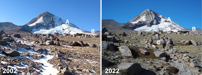
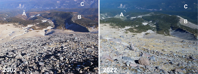
Above the old warming hut, the Cooper Spur Trail heads into tundra country (above) as it nears the 7,000 foot elevation on the mountain. From this perspective, the retreat of the Eliot Glacier starts to become apparent, especially to those familiar with the area. The rounded ice crest known to climbers as the Snow Dome (A) is notably smaller and the depth of the glacier has receded enough in the lower reaches (B) to drop beyond the top of the east moraine from this perspective. In the foreground (C) alpine wildflowers continue their march to higher elevations where only a few grasses once grew because of once-lingering snowpacks.

[click here for a large version]

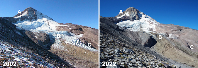
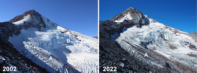
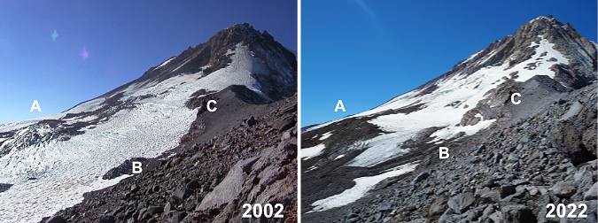
This photo pair (above) is from the first big view of the Eliot Glacier from the Cooper Spur Trail. The change over the past 20 years is unmistakable here. On the upper shoulder of the mountain (A), the snowfields that once led climbers to the summit well into summer are much smaller, making this approach in summer a very sketchy affair today, with much falling rock. 

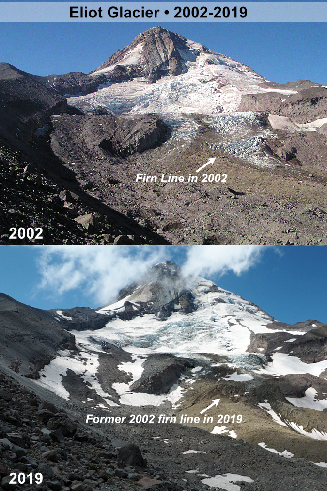
This pair of images also shows how the lower Eliot Glacier icefall has changed dramatically in just two decades of glacial retreat. The blue chaos of seracs and crevasses (B) that were once a prime ice climbing destination are now well below the “firn line”, the point at which a glacier is losing more ice than it is gaining. This line is generally where a glacier changes from blue and white clean ice to a gray mix of ice and rock, as the glacier gradually shrinks and melts in its descent. Further down (C), the decreasing depth of the glacier is especially notable where blue and white ice have disappeared.

[click here for a large version]

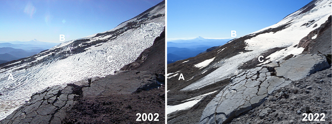
The next pair of images (above) is from an overlook just below the crest of Cooper Spur, at about the 8,000 foot elevation. Here, the Eliot Glacier is still impressive and awe inspiring as a mass of tumbling ice and wrinkled crevasses. The notable change in these views is the thinning of the ice (A and C) along the glacier’s margins, with piles of rubble appearing between lobes of flowing ice. The main icefall (B) also has some underlying rock showing as yet another sign of the thinning of the ice sheet

[click here for a large version]

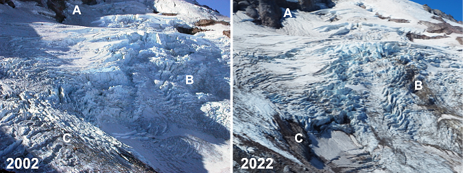
This pair (above) is simply a closer look at the main icefall from the same vantage point, showing (A) where the thinning ice mass has revealed more of the north wall of the mountain, and (b) where rock outcrops are now pushing through the icefall from below. Icefalls form because of these outcrops, so the appearance of the underlying rock is measure of the glacier depth decreasing. Twenty years ago, enough ice flowed over this outcrop to completely overwhelm it, whereas today we’re beginning to see traces of the rock beneath the glacier.

[click here for a large version]

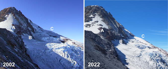
This is another view of the Eliot Glacier from just below the crest of Cooper Spur, looking across the upper part of the glacier. Here the shrinking snowfields on the climbing route above Cooper Spur (A) are more apparent, as are the exposed cliffs (B) below the north face of the mountain, where the thinning ice has revealed a vertical well. On the shoulder of the mountain, a once-crevassed section of moving glacier has slowed to become a snowfield along the margin of the glacier.

[click here for a large version]

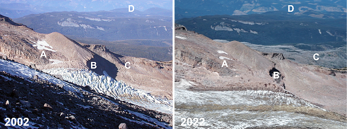
This photo pair (above) is looking across the Eliot Glacier from the crest of Cooper Spur, at about 8,500 feet elevation. It’s subtle, but the permanent snowfields (A) along the upper end of the Langille Crags are smaller today, and the lower icefall (B) is dramatically diminished, as shown in previous views. In the near distance (C) the silver ghost forest of the 2011 Dollar Lake Fire shows up today along the Mount Hood’s northern foot. In the far distance (D) the massive (and completely unsustainable) logging spree being carried out by timber giant Weyerhauser since taking over the timber holdings in the West Fork Hood River area a few years ago is painfully apparent.

[click here for a large version]

This pair (above) is a closer view of the previous set, focusing on the lower Eliot Glacier icefall. This comparison shows the thinning of the ice sheet (A and B) against the cliffs of the Langille Crags, and (C) the dramatic change on the near side of the glacier, where the firn line has moved several hundred feet up the mountain over two decades.

[click here for a large version]

Moving away from the Eliot Glacier, this photo pair (above) shows the broad east slope of Cooper Spur from the crest, looking toward the canyon of the East Fork Hood River. The changes here are subtle, but still notable. Historic Cloud Cap Inn (A) still stands, despite being threatened by both the 2008 Gnarl Ridge Fire and 2011 Dollar Lake Fire. The ghost forests of the Gnarl Ridge Fire (B) are recovering rapidly today, filled with understory and rapidly growing Western Larch seedlings that are now 6-8 feet tall. In the distance, the human scars (C) caused by Forest Service clear cutting on the slopes of Surveyors Ridge in the 1980s and 90s are gradually fading away, too, as the forests there slowly recover.

[click here for a large version]

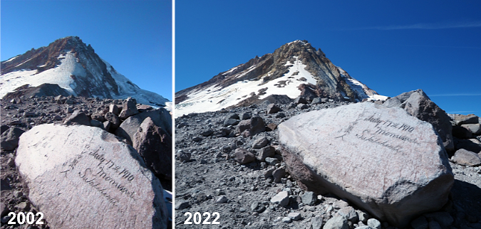
Happily, not much change at Hiroshima Rock (above) in 20 years – or even 122 years! This unlikely etching by a 1910 Japanese Climbing expedition has somehow survived more than a century of fierce ice and sand blasting, perhaps because the carving is on the leeward side of the rock? It remains a favorite touchstone for hikers passing through. Here’s an earlier blog article on this unique message from the past.

[click here for a large version]

This photo pair (above) is looking back toward the crest of Cooper Spur from a bit further up the mountain, with a feature known as Tie-in Rock in the foreground. As in previous photos, the burn scars (A) of recent forest fires can be seen in the distance. The seemingly inescapable modern phenomenon of rock stacking (B) is present on Tie-in Rock, too. Size is hard to gauge here, but the rock is about 15 feet tall and takes some effort scale — much less with rocks in hand! The Newton Clark Glacier’s retreat (C) is somewhat noticeable on the far right, though the changes are much more apparent in the image pairs that follow.

[click here for a large version]

This image pair (above) provides full-on view of the Newton Clark Glacier from Cooper Spur. This sprawling glacier faces southeast, and because it catches summer sun from sunrise until late afternoon, it is has been more visibly impacted by climate change than the northeast-facing Eliot Glacier. What was once an icefall (A) 20 years ago is now bare rock, with the glacier flowing around it. Along the margins of Cooper Spur (B and C) the shrinking expanse of the glacier is prominent.

[click here for a large version]

This is a similar view (above) looking south across the Newton Clark Glacier. Like the Eliot Glacier, the lower, blue and white ice crevasses (A) on the glacier have fallen below the firn line, replaced by a grey mix of moving rock and ice. On the far shoulder of the mountain the former icefall at the center of the glacier (B) has receded around the rock outcrop that once produced it. In the foreground (C), the thinning of the overall ice sheet is dramatic over just two decades. Mount Jefferson is visible on the far horizon.

[click here for a large version]

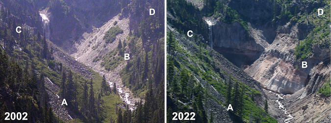
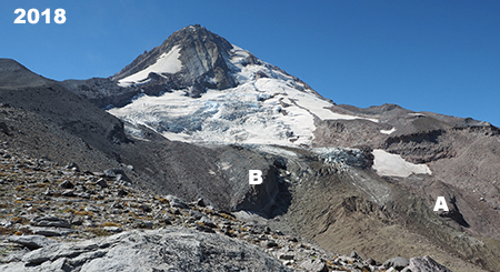
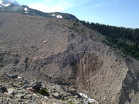
This photo pair (above) is from far below Cooper Spur, at an overlook above the Eliot Branch called Inspiration Point. I’ve included it in this series because the retreat of the glacier has had dramatic impacts downstream, too. As the glacier continues its retreat, the Eliot Branch is cutting a v-shaped channel into the soft, flat valley floor that was once beneath the glacier, releasing vast amounts of rocky debris into the stream below. Compounding that effect are periodic flood events that have repeatedly scoured the canyon. As this pair shows, the changes are extensive. 

For reference, a grove of three trees (A) in the lower center of the above photo pair have dodged the mayhem, though a group just below this trio has been swept away by the Eliot Branch. Meanwhile, an entire stand of trees (B) on the west wall of the canyon has slipped away in a massive landslide, revealing raw, banded volcanic bedrock, below. Another stand of trees on the east side of the canyon (C) burned in the 2011 Dollar Lake Fire, as did the remaining trees (D) in the upper west side of the canyon. This continues to be a very active, dynamic area, with constant changes to the river channel and canyon walls.

[click here for a large version]

The final photo pair is a longer comparison of just over 120 years, as seen from Cloud Cap Inn. Mirroring the changes shown throughout this article, the Eliot is a much smaller glacier today than it was when my own grandparents were born around 1900. The mass of ice and rock (A) that once made up the terminus would be enough to fill up much of downtown Portland. The lesser-known Langille Glacier (B) has almost certainly stopped moving, and has become a series of icefields. The Coe Glacier (C) is also in retreat, despite its shady location on the north side of the mountain.

Changes like those we are seeing on Mount Hood are tough to absorb, and thus I was determined to end this article on a hopeful note. Why? Because I’m a hopeful and optimistic person to the core, but also because there is much we can do to slow the climate change that is affecting so much of our world.

[click here for a large version]

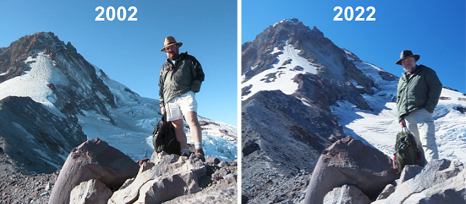
We’re not powerless against these changes, though we do have a limited time on this planet to do our part. And thus, the final image pair (above). Why, it’s me! In 2002 I was a 40-year-old with blond hair and a red beard. Fast forward to 2022 and… well, at age 60 there’s not much hair left and the beard has turned decidedly gray. Time is not on my side, to be sure, but there is plenty more I can do in my life!

The benefit of 20 more years of living is the knowledge that I can still hoof it to the top of Cooper Spur (if a lot more slowly — and feeling it more the next day, too!) and still see things I’ve never noticed before. In 2002 I was still just thinking about how I could help keep the century-old idea of a national park around Mount Hood and the Gorge alive. Two years later, I started the Mount Hood National Park Campaign website to put the idea into words and pictures (and yes, it does need an update!). Six years later, I started writing this blog to continue celebrating the future Mount Hood National Park. That’s something I can continue to do even when getting to the top of Cooper Spur is finally out of my reach!

At age 60 I know I can’t single-handedly stop the changes happening on Mount Hood and in the Gorge, whether it be from climate change to just the sheer growth in the number of people coming here. But age DOES bring the super-power of perspective that can only come from time and lived experience — and in my case, I’ve also got the photos to prove it! I’m able to put a face on those changes to help inspire caring and action toward a new vision for the future, one that focuses on sustainability and adaptation in the face of change. That’s the point of this article and the WyEast Blog, of course.

And what about the future..?

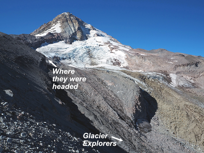
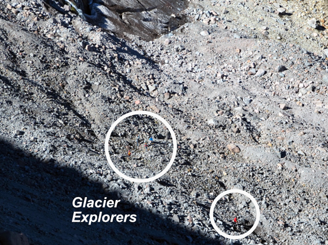
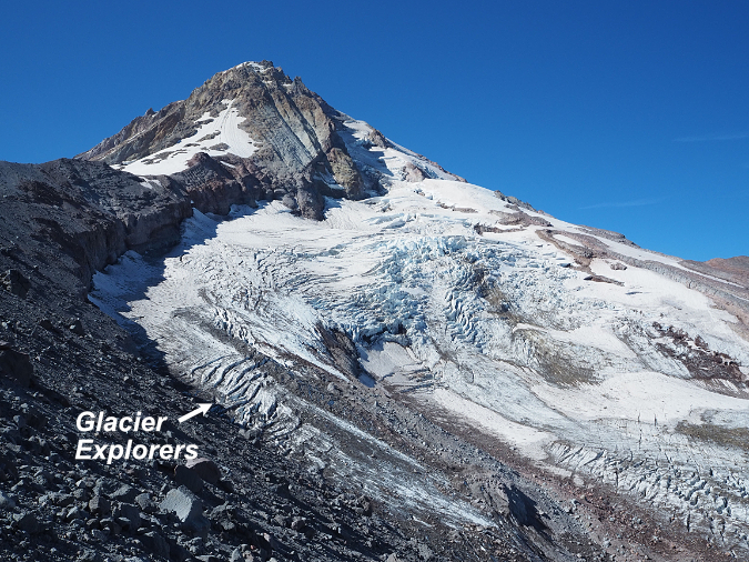
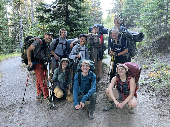
Throughout that day on Cooper Spur in September, I watched a group of young glacier explorers far below me, working their way through rock debris and over crevasses as they approached the main icefall on the Eliot Glacier. I took a few photos of the group along the way, and was thus delighted to run into them on their return to the trailhead that afternoon. I turns out they were students from Pacific University’s Outdoor Leadership Program, led by instructor Philip Friesen. 

If the then-and-now photos of changes on Mount Hood are tough to look, this is where the real hopefulness in this article comes in. Phil’s program at Pacific is pointing a new generation of future leaders toward a life and careers in the outdoors that I believe will be transformational for many of the environmental challenges we’re facing today. 

When I asked, here’s how Phil describes his program:

“I think the main thing to share with the world is that the students in our program focus on addressing systemic oppression and environmental issues while learning how to courageously lead others into the mountains, on rivers, and on the rock–we combine the joy of being outdoors in nature with the challenge of meeting some of our society’s biggest challenges.”

And there are many other educators like Phil out there helping young people of today turn their passion for the outdoors and their hunger to enact positive change into lifelong careers that will have a real impact in making a better world. As an old guy with only a few years left to do my part, I find this so inspiring and reassuring!

Phil Friesen (left) and his group of Pacific University students from the Outdoor Leadership Program are all smiles last September, even after a grueling climb up the Eliot Glacier!

Students in Phil’s program spend extensive time in the outdoors, learning how to hike, climb and kayak, so that they may be able to bring the outdoor experience to others over their lifetimes. This is the very best path toward conservation and sustainability, especially for our public lands. Only when we spend time there can we begin to feel the personal sense of ownership necessary to care for and protect these spaces in perpetuity.

I have great faith in what we have named “Generation Z”, and so does Phil. Young people majoring in Outdoor Leadership at Pacific are readying themselves for a life doing what they love, whether it be as a guide, ranger, naturalist or many other emerging careers in the growing outdoor industry. They’re also learning about the history of exclusion on our public lands, and the urgent need to remove barriers so that all Americans can enrich their lives in the same way that the most privileged among us already do. That hits home for them, too, as they are by far the most diverse generation in our history. 

Phil plans to share these images with his students, most of whom were born around 2002, when I took that first set of photos. They will likely find them jarring, as they only know the Eliot Glacier of today, and may not realize how quickly it is fading away. But they have an abundance  of passion for the environment, and I do think these photos will lend still more urgency to them in their commitment to make our world a better place.

The author getting his head straight in the shadow of mighty WyEast before heading home for  another week in civilization (Photo by Andy Prahl)

The real power of the Outdoor Leadership Program – and this is true for anyone who spends time in the outdoors – is the cascade of reflections that immersion in nature fosters. No matter your walk of life, time on a trail, among the trees or through mountain meadows, ensures the perspective, peace of mind and hopefulness needed to make the rest of our busy lives more successful. I refer to as my mental health time, when I get my head straight before another week of Zoom meetings and e-mails. Phil’s students are learning this early on, and I’m certain it will be as restorative and rejuvenating in their lives as it is in mine.

Phil’s group was all grins after a grueling day climbing up a glacier. Such is life when you’re 20 years old! They don’t know it yet, but they are part of what could be the most consequential generation in our history. They have no choice but to grapple with enormous challenges that my own generation has so short on. But because I do get to spend a fair amount of time around today’s Generation Z, I’m more certain than ever that they are special. They are uniquely up for the challenge. Phil’s students are way too young to know this quote that has guided since childhood, but they are nonetheless embracing it like no generation has before them:

________________

“Unless someone like you cares an awful lot,

it’s not going to get better. It’s not.”

-The Lorax

________________

And a final note to Phil Friesen and his Outdoor Leadership Program students: Thank you for the great things you are about to do!

________________

Author’s postscript: My best to all who have followed this blog over these many years! I greatly appreciate the support and especially your passion and concern for the future of our WyEast Country. I have a bunch of new articles planned for the coming year and look forward to sharing them with you!

In the meantime, I hope to see you on the trail!

Tom Kloster • January 1, 2023
WyEast Bats Last: The White River Saga Continues!

Mount Hood and the White River as it appeared early in the summer of 2020

Mount Hood’s glaciers may be retreating, but if anything, the melting ice and more extreme weather that climate change is bringing to the mountain have only made the streams that emerge from its glaciers that much more volatile. 

Glacial streams are inherently intimidating: ice cold and rising dramatically within hours when glacial melting accelerates on hot summer days to become churning river of mud and silt. They can make for terrifying fords for Timberline Trail hikers and wreak havoc on downstream roads and streambanks. But the worst events typically come in fall or late spring, when sudden warming and heavy rain can trigger rapid snowmelt on the mountain, turning these streams into unruly torrents.

Highway 35 was buried under a sea of boulders in the November 2006 White River debris flow (ODOT)

Such was the setting in November 2006, when a warm front with heavy rains pounded the mountain, rapidly melting the first snows of autumn that added to the explosive runoff. The worst damage to infrastructure came from the raging White River and Newton Creek, two glacial streams that emerge from the southeast side of the mountain. The streams also happen to flank the Meadows ski resort, so when both streams effortlessly swept away whole sections of the Mount Hood Loop highway (OR 35), the resort suddenly found itself cut off from the rest of Oregon.

The 2006 floods washed away the bridge approaches and stacked boulders eight feet deep on top of the former White River Bridge (ODOT)

Highway worker posing with a boulder dropped by the White River on the centerline of Highway 35 during the 2006 floods (ODOT)

Oregon Department of Transportation (ODOT) crews quickly restored temporary access to the resort, but the damage to the highway was profound. Newton Creek had simply swept away the roadbed along an entire section of the highway, while the White River had swept away the bridge approaches on both sides of the concrete span over the stream – then proceeded to pile a collection of boulders on top of the stranded bridge, just for emphasis! 

This overflow culvert at the east end of the old bridge approach was overwhelmed in the 2006 flood, as the White River spilled over the top of the highway, instead (ODOT)

Undaunted, the highway engineers at ODOT and the Federal Highway Administration turned to a recently completed 2003 study of design solutions for several flood-prone spot along the Highway 35. From these, a pair of projects totaling $20 million were proposed to finally tame the two streams – a “permanent” fix, as the study described it.

East of the White River, the 2006 floods also sent a torrent of water and debris down Newton and Clark Creeks, erasing sections of Highway 35 near Hood River Meadows (ODOT)

Once again, the plan was to go bigger. For Newton Creek, the now rebuilt highway includes a massive, 30-foot wide, rock-lined flood channel running parallel to the highway, with box culverts periodically spaced to allow floodwaters to cross under the road. For the White River, a series of option were considered, including a tunnel (!) and completely relocating the highway. But in the end, the option of simply replacing the older span with a much larger bridge was selected. The new bridge was completed in 2012.

Options considered in the 2003 study of possible Highway 35 crossings of the White River

[click here for a larger version of this table]

The preferred option for the White River also included a second span over Green Apple Creek, a small stream located just east of main crossing, and a feature that would serve as an overflow for the White River. Between the bridges, the new highway crossing is constructed on a high berm of fill, twenty feet above the expanse of sand and boulders that make up the White River floodplain, and berms also support the approaches to both bridges on either side of the floodplain.

When they were completed in 2012, six years after the floods that had swept away sections of the highway, these structures seemed gargantuan compared to the previous incarnation of the highway. Yet, looking down upon the new White River Bridge from higher up on the mountain, it is really nothing more than a speed bump for the raging monster the White River is capable of.

The White River has been moving east for several years. This view is from early summer 2020, when the upstream section of the river had already moved almost to the east canyon wall

For the past decade, the new structures seemed to be working as planned by the highway engineers. The White River continued to meander about in its wide flood channel, as it has for millennia, but it still found its way to the newer, bigger bridge opening. Until last winter, that is.

Sometime during the winter of 2020-21, the river abruptly formed another new channel along the east side of its floodplain, beginning about one mile above the new highway bridge. In recent years, the river had been gradually moving in this direction, including a smaller flood event in the fall of 2020 that spilled debris into the White River West SnoPark. Today’s radically new channel is a continuation of this eastward movement, almost to the east wall of the canyon. 

This view from the fall of 2020 followed a debris flow that sent rock and gravel into the White River West SnoPark and set the stage for the big shift in the river’s course that would follow over the coming winter. The river was actively meandering across the latest flow in this view, settling on a new course

The berm in the center of this view was built after the 2006 floods to project the White River West SnoPark parking area (on the right) from future flooding (the White River floodplain is on the left). The fall 2020 debris flow managed to breach the berm, spreading rock and gravel across the southern corner of the parking area (the third car and most distant car in this photo is parked on the debris). The new (and now dry) White River Bridge is in the distance

By the spring of 2021, the White River had completely abandoned the main floodplain and now flows beyond the row of tress in the far distance

Looking downstream from the new White River Bridge in 2021, the former riverbed is now completely dry, with the river now flowing beyond the band of trees on the left

The White River Bridge is only a few years old, but now spans only a dry streambed

This decision to include a second bridge in the new design turned out to be fortuitous over the last winter, at least in the near term. This “overflow” bridge is now the main crossing of the recently relocated White River. Had ODOT opted to simply replace the culverts that once existed here, the river would have easily taken out a section of the berm that supports the highway between the two new bridges, closing the highway, once again. However, the second span is much smaller than the main span, so it is unclear whether the river will continue to cooperate with the highway engineers and stick to this unplanned route.

This view shows the new channel carved by the White River sometime during the winter of 2020-21

The White River carved a 20-foot-deep riverbed through loose floodplain material to form the new channel

The new bridge design included this secondary opening as a backup to the main bridge, though it is now the primary crossing of the relocated White River. The highway slopes downward as it moves east of here, dropping below the elevation of the White River floodplain, and thereby creating the potential for the river to migrate further east, threatening the fill section of the highway in the distance in this view

The channel shifts on the White River might seem to be sudden, but in reality, they are perpetual. The White River (along with the rest of Mount Hood’s glacial streams) bring tremendous loads of rock and silt with them. This has always been the case, with melting glaciers releasing debris caught up in the river of ice, some of it building piles of rock called moraines, and some carried off by the rivers that flow from the glaciers.

In the past few decades, the cycle of glacial erosion has been compounded by the retreat of the glaciers, themselves. All of Mount Hood’s glaciers are rapidly losing ice in the face of a warming climate, and the retreat of larger glaciers like the White River, Eliot, Sandy and Coe leaves behind bare ground once covered in ice. 

When this happens, and erosion shifts from slow-moving ice to fast-running water, the amount of debris and water moving down the glacial streams grows dramatically. The following diagram (see below) explains this relationship in the context of the rapidly retreating Eliot Glacier, Mount Hood’s largest body of ice, located on the mountain’s northeast side.

[click here for a larger version of this schematic]

Glaciers plow wide, U-shaped valley as they grind away at the mountain, whereas streams cut deep, V-shaped canyons. When glaciers like the Eliot retreat, they expose their u-shaped valleys to stream erosion, and their outflow streams (in this case the Eliot Branch) immediately go to work cutting V-shaped canyons into the soft, newly exposed valley floor, resulting in much more material moving downstream in more volatile events.

In the schematic, the lower part of the Eliot Glacier is somewhat hidden to the casual eye, as it’s covered with rock and glacial till. This is true of most glaciers – the white upper extent marks where they are actively building up more ice with each winter, and the lower, typically debris-covered lower extent is where the ice is actively melting with each season, leaving behind a layer of collected debris that has been carried down in the flowing ice.

The terminus of the glacier in the schematic marks the point where the Eliot Branch flows from the glacier. As the terminus continues to retreat uphill with continued shrinking of the Eliot Glacier, more of the U-shaped glacial valley floor is exposed. At the bottom of the schematic, the floor of the valley has been exposed for long enough to allow the Eliot Branch to already have eroded a sizeable V-shaped canyon in the formerly flat valley. This rapid erosion has fed several debris flows down the Eliot Branch canyon in recent years, including one as recently as this month, abruptly closing the road to Laurance Lake. 

The Eliot Branch continues to spread debris flows across its floodplain, burying trees in as much as 20 feet of rock and gravel. This section of the Eliot Branch flooded again earlier this month, closing the only road to Laurance Lake

We’ve seen plenty of examples of this activity around the mountain over the past couple of decades, too. In 2006 the mountain was especially active, with flooding and debris from the Sandy, Eliot, Newton Clark and White River glaciers doing extensive downstream damage to roads – this was the event that removed the highway at the White River and Newton Creek. Smaller events occurred in 1998, as well. In the 2006 event, the Lolo Pass Road was completely removed near Zigzag and the Middle Fork Hood River (which carries the outflow from the Eliot and Coe glaciers) destroyed bridges and roads in several spots.

Even in quieter times, the White River has moved its channel around steadily. That’s because the heavy debris load in the river eventually settles out when it reaches the floodplain, filling the active river channel. This eventually elevates the river to a point where it spills into older channels or even into other lower terrain. Because of the broad width of the White River floodplain at the base of the mountain, this phenomenon has occurred hundreds of times over the millennia, and the river will continue to make these moves indefinitely. 

To underscore this point, the 2003 highway study of potential solutions for Highway 35 includes this eye-opening chart that shows just how many times the White River has flooded the highway or overtaken the bridges – nearly 20 events since the highway was first completed in 1925!

[click here for a larger version of this timeline]

Therein lies the folly of trying to force the river into a single 100-foot opening (or even a second overflow opening) on a half-mile wide floodplain. The fact that much of the floodplain is devoid of trees is a visual reminder that the river is in control here, and very active. It has a long history of spreading out and moving around that long precedes our era of roads and automobiles.

But the White River has an added twist in its volatility compared to most of the other glacial streams that flow from Mount Hood. The vast maze of sandy canyons that make up the headwaters of the White River are quite new, geologically speaking – at least as they appear today. This is because of a series of volcanic events in the 1780s known as the Old Maid eruptions covered Mount Hood’s south side with a deep blanket of new volcanic debris. The same gentle south slopes that Timberline Lodge and Government Camp sit on today didn’t exist before those eruptions, just 240 years ago.

The White River Glacier (center) flows from near the crater of Mount Hood, and rests upon soft slopes of rock and ash debris that were created by the Old Maid eruptions of the 1780s. The large rock monolith poking up from the crater (left of center) is Crater Rock, an 800-foot lava dome that formed during the Old Maid eruptions

The Old Maid eruptions created other new features on the mountain – notably, 800-foot Crater Rock, a prominent monolith that was pushed up from the south edge of the crater. Meanwhile, the eruptions also generated lahars, the name given to sudden, massive mudflows that can range from ice cold to boiling, depending on the origin of the event. These flows rushed down the White River, Zigzag and Sandy River valleys, burying whole forests under debris ranging from mud and silt to boulders the size of delivery trucks.

The Old Maid eruptions take their name from Old Maid Flat, located along the Sandy River, where a new forest is still struggling to take hold on top of the volcanic debris, more than two centuries later. At the White River, trees buried by the lahars can be seen in the upper canyon, where the river has cut through the Old Maid eruption debris to reveal the former canyon floor, and trees still lying where they were knocked over (more about those buried forests toward the end of this article).

From high on the rim of the White River canyon, the endless supply of rock and ash from the Old Maid deposits is apparent – along with the impossibly tiny (by comparison) “bigger bridge” over the White River

This telephoto view of the new White River bridge from the same vantage point in the upper White River canyon reveals the structure to be a mere speed bump compared to the scale and power of the White River

For this reason, the White River has an especially unstable headwaters area compared to other glaciers on the mountain, with both glacial retreat and the unstable debris from recent lahars triggering repeated flash floods and debris flows here. That’s why the question of whether the new, bigger and bolder highway bridge over the White River will be washed out is more a question of when. It will be, and in our era of rapid climate change, the answer is probably sooner than later.

Is there a better solution? Perhaps simply acknowledging that the river is perpetually on the move, and designing the road with regular reconstruction in mind, as opposed to somehow finding a grand, permanent solution. That’s at odds with the culture of highway building in this country, as it could mean simply accepting more frequent closures and more modest bridge structures – perhaps structures that could even be moved and reused when the river changes course?

The 2003 Federal Highways study actually acknowledges this reality, even if the brawny, costly designs that were ultimately constructed in 2012 do not:

“It is imperative to remember that geological, meteorological, and hydrological processes that result in debris flows, floods, and rock fall have occurred for millions of years, and will occur for millions of years to come. They are naturally occurring phenomena that with current technology cannot be completely stopped or controlled. Thus, the best that can be hoped for is to minimize the destructive, highway– closing impacts of events at the study sites.” (FHWA Highway 35 Feasibility Study, 2003)

The White River seems to be enjoying its new channel and change of scenery…

In the meantime, the newly relocated White River an awesome sight. We’re so accustomed to bending nature to our will in this modern world that it’s refreshing to see a place where nature has no intention of being fenced in (or channeled, in this case). 

Do rivers have a sense of humor or experience joy? As I looked down upon the White River sparkling and splashing down its new channel this summer, it seemed to be thoroughly enjoying the pure freedom of flowing wherever it wants to. It’s yet another reminder that “nature bats last”, and in WyEast country, the mountain – and its rivers — will always have the final word. 

For us, it’s that strangely comforting reminder that we’re quite insignificant in the grand scheme of things, despite our attempts to pretend otherwise.

How to visit the White River

If you’re interested in experiencing the living geology of the White River, an easy introduction is to park at the White River West SnoPark area and trailhead, then head up the trail toward the mountain for a quarter mile or so. From here, the river has moved to the far side of the floodplain, but for the adventurous, it’s cross-country walk across sand and boulders to reach the stream. There, you can soak your feet in ice cold, usually milky water and watch the river moving the mountain in real time, pebble-by-pebble. The main trail is almost always within sight, so it would be tough to get lost in the open terrain here.

Look closely – those tan stripes near the bottom of the White River canyon mark the pre-Old Maid eruption slopes of Mount Hood, now buried under ash and debris from the lahars. Several preserved trees that were knocked down by the eruption can be seen along these margins. This viewpoint is along the Timberline Trail, just east of Timberline Lodge.

To see the relocated White River, park at the White River East SnoPark and walk to the east bridge – now the main crossing of the White River. The view upstream includes the top of Mount Hood, but watch out for speeding traffic when crossing the highway!

To see the buried White River forest, you can park at Timberline Lodge and follow the Timberline Trail (which is also the Pacific Crest Trail here) east for about a mile, where the trail drops to the rim of the upper White River canyon. The views here are spectacular, but if you look directly below for a waterfall on the nearest branch of the White River, you’ll also see the reddish-yellow mark of the former valley floor and the bleached remains of several ghost trees buried in the eruptions 240 years ago. Watch your step, here, and stay on the trail – the canyon rim is unstable and actively eroding!

___________________

Tom Kloster | July 2021

2021 Campaign Calendar!

As I write this annual year-end post after a calamitous 2020, the world seems just a bit more hopeful. The presidential election will shift public lands policy 180 degrees back toward conservation and restoration, and with the release of two COVID-19 vaccines, the end of the world pandemic is finally on the horizon.

And so, I share some of the stories behind this year’s Mount Hood National Park Campaign scenic calendar with a cautious spring in my step (or my fingers as they type this sentence, at least). You can pick up a copy of the calendar here for $29.95:

2021 Mount Hood National Park Campaign Scenic Calendar

As always, all proceeds will go to Trailkeepers of Oregon (TKO) to support their ongoing effort to care for trails as gateways to our public lands. Zazzle prints these calendars with exceptionally high quality, and they also have large enough boxes to be quite functional for tracking important dates and your trail plans. They make nice gifts, too, of course!

Over the years, I’ve described the Mount Hood National Park Campaign as “an idea campaign” with the simple goal of keeping alive the promise of better protections and restoring the grandeur Mount Hood and the Gorge. I started the project in 2004 as a way to continually remind Oregonians and Washingtonians living in WyEast Country that national park protection was proposed at least three times in Congress, in the 1890s, 1920s and the 1930s. Each time, logging and other extraction industries (and later, the emerging ski industry) were the chief opponents — along with the Forest Service, itself.

Thomas Cole painted this idyllic scene of Native American life in WyEast Country in the 1870s. The mountain continues to be beacon of inspiration and awe for people living in its shadow to this day

If you’ve watched Ken Burns’ magnificent National Parks series, you know that every park was a battle, typically between short-term exploitation interests and progressives looking toward posterity for future generations. There were no easy wins.

And, so it will be for Mount Hood and the Gorge until enough locals (or our children and grandchildren) recognize national park protection as both urgent and deserving for these world-class places. We haven’t treated them too well over the past 150 years, but real change is suddenly afoot in 2020. What? Yes, you read that correctly… and I will share more about that exciting news in future blog posts!

This beautiful cove at the foot of Crown Point was called “Echo Bay” when it was still connected to the Columbia River in this 1870s photo. This was among the spots that inspired the first Congressional effort to create a national park here

But until then, this article is a tour of some of the places that make WyEast country special, and are featured in the 2021 MHNP Campaign scenic calendar. As always, every image in the new calendar was captured over the past year and, as in past years, there are some lesser-known places mixed in with some of the more familiar.

The 2021 Calendar Images

Salmon River in late Autumn

The cover image for the 2021 calendar comes from a very familiar spot along the Old Salmon River Trail, near the community of Zigzag. This quiet trail was bypassed — and spared — when the Salmon River Road was built in the post-World War II logging boom. Today it offers one of the most accessible trails into ancient rainforest anywhere in the Pacific Northwest. This photo was taken just a few weeks ago, too. Because of its low elevation, it’s a trail you can hike year-round. Here’s the Oregon Hikers Field Guide description of the trail.

For January, I chose an image captured from above the West Fork Hood River Valley, on Butcher Knife Ridge. In this scene, Mount Hood is emerging from the clouds after the first big winter storm of fall. I’ll be posting more articles in 2021 about the West Fork valley, as there is some very exciting news to share about this area.

Mount Hood’s rugged northwest face in early winter as viewed from Butcher Knife Ridge

The February image is a familiar view of Wahclella Falls on Tanner Creek, one of the premier trails in the Columbia River Gorge. Before the 2017 Eagle Creek Fire, I visited this trail several times each year, as it’s not only a personal favorite, but also a trail that makes for a great introduction to the Gorge for new hikers or visiting family.

Wahclella Falls on Tanner Creek

The image in the new calendar is from a visit last winter, and it was my first since the fire. Though the fire did burn through the lower Tanner Creek canyon, many trees survived, especially around Wahclella Falls. Notably, a pair of big trees familiar to hikers also survived — the twin Douglas firs flanking the lower trail (below). As of this year, their upper canopies are still green more than two years after the fire, and that bodes well for them to survive for many years to come.

The familiar twin Douglas firs along the Wahclella Falls Trail have survived the 2017 Gorge fire… so far

What I couldn’t have guessed is that the COVID-19 pandemic restrictions kicked in just a couple weeks after my visit, and Wahclella Falls was once again closed to the public.

As hard as these Gorge trail closures have been for hikers, there are a couple of silver linings. First, they have allowed trail volunteers from TKO, the Pacific Crest Trail Association (PCTA) and other volunteer trail organization to continue the hard work of restoring trails damaged by fire without having to accommodate hiker traffic. Perhaps more importantly, the closures have also allowed forest recovery to begin within the pressures that heavy visitation on popular Gorge trails brings.

Lower White River Falls in spring

The March image (above) features Lower White River Falls, a lesser-known cascade downstream from the main falls at White River Falls State Park. Where the main falls is a raucous spectacle, the lower falls is quiet waterfall in a secluded canyon, where it is framed by desert wildflowers in late spring.

Poison likes to grow in the shade of boulders along the White River — watch where you sit!

The user path to the lower falls has become increasingly prominent in recent years as more visitors discover this pretty spot (and its excellent swimming hole), but be forewarned, the path is lined with Poison Ivy. This relative of Poison Oak bears a close resemblance, but grows as a ground low ground cover in the sandy floodplain along the river, often in the shelter of boulders and old logs.

Lower White River Falls

For April, I selected another scene from Mount Hood’s rain shadow, a wildflower meadow on the edge of the tree line where forests give way to the desert country east of the Cascades. This bucolic scene looks across the rolling wheat country of Wasco County, toward the Columbia Hills and the Columbia River, on the horizon (below).

Wildflower meadows on the east slope of the Cascades near Friend

Though you wouldn’t know from this photo, the South Valley Fire swept through this area in 2018, one of three major range fires that combined that year to burn nearly 200,000 acres. Two years later, and only the scattered snags of Ponderosa pine, Western juniper and burned fence posts hint at the fire, as the sage and grass savannah has recovered in a remarkably short time. But the fires had a human toll, too. Homes and barns were burned, as well as several historic farmsteads that can never be replaced.

Only a few charred remains tell the story of the 2018 range fires east of Mount Hood

Switching back to the west side of the Cascades, I chose a scene from a visit to Silver Falls State Park for the May image. With many of the Gorge waterfall trails still closed by the aftermath of the Eagle Creek Fire, Silver Falls visitation has exploded over the past couple years, as hikers look for new places to get their waterfall fix.

Visiting Silver Falls State Park is pretty close to a national park experience, as the park is loaded with 1930s Civilian Conservation Corp construction and the Oregon Parks and Recreation Department do an excellent job maintaining and curating the park’s network of scenic trails. Lower South Falls (below, and the May image in the new calendar) and nearby Middle North Falls are favorites among photographers in the park, and they have some similarities. Both begin as a wide curtain of falling water before crashing onto the rocky basalt aprons that make up their base, and both have a trail behind them.

Lower South Falls on Silver Creek

A few years ago, a local Republican legislator introduced a bill proposing National Monument status for Silver Creek. The bill didn’t go anywhere, but it was a nice opportunity to showcase the area and a reminder that seeking national park status can be a bipartisan effort, even in these days of deep political division.

Pandemic-compliant blogger at Silver Creek State Park

Visiting Silver Falls State Park (and most other state parks) in 2020 also meant controlling the COVID-19 virus while huffing and puffing on a buy trail. While I was discouraged by the disregard for masks on my trips to Silver Falls last spring (maybe 1 in 5 had one), there has been a noticeable uptick in mask use in our state parks national forests since. That’s good, because in a year of pandemic shutdowns and closures, the benefits of being outdoors and connecting with nature have never been greater.

Crowds of pandemic-defying hikers at Silver Falls State Park on Memorial Day 2020

For June, I chose a scene from just off the Timberline Trail, along the rim of the White River Canyon (below). This expansive Lupine meadow is only a few steps from the trail, but just out of view and thus known to surprisingly few.

Summer Lupine meadows along the rim of White River canyon

If only this blog had a virtual scratch-and-sniff, as there is nothing quite as heady as the sweetly-scented mountain air in a Lupine meadow, and this one was no exception. For those who haven’t had the experience, Lupine are in the pea family, and have the same sweet aroma as garden sweet peas — but with a mountain backdrop!

For July, I chose another wildflower scene, though this one fits more of a rock garden motif, featuring yellow Buckwheat and purple Penstemmon among the chunks of andesite scattered here. This is the historic Cooper Spur shelter, just off the Timberline Trail on the mountain’s north side. Cooper Spur, proper, rises to the left and the Eliot Glacier tumbles down Mount Hood’s north face to the right of the shelter. This is one of several stone shelters built by the Civilian Conservation Corps in the early 1930s and today is one of just three that still survive (the other survivors are at McNeil Point and Cairn Basin).

Cooper Spur Shelter in summer

Follow the climbers trail to the right of the shelter to the nearby moraine viewpoint (marked by large cairn) and you’ll have a front-row view of the Eliot Glacier. While I was there, a house-sized ice blocks suddenly collapsed (below), filling the canyon with a roar! It’s always a thrill to see and hear our glaciers in action.

Icefall collapse on the Eliot Glacier!

Another mountain scene fills out the summer as the August image in the new calendar. This multi-image composite assembles the impossibly massive scene at the western base of the mountain, where the Timberline Trail fords the twin branches of the Muddy Fork (below). From here, the mountain rises more than 7,000 vertical feet above the scene, and dramatic waterfalls tumble down the 800-foot cliffs that frame the canyon.

The wide-open scenery of the Muddy Fork canyon

The Muddy Fork valley is a volatile, continually changing landscape. In the early 2000s, a massive debris flow swept through, felling an entire forest and leaving a 25-foot layer of rock and sand on the valley floor. The Muddy Fork has since carved through the debris, all the way down to the former valley floor, revealing the stumps of trees that were snapped off by the event. Some are visible along the stream at the center the above photo. Meanwhile, the rest of the Muddy Fork debris flow is already dense with Red Alder, Cottonwood and Douglas Fir pioneers that are quickly re-establishing the forest, continuing the eternal cycle of forest renewal.

Several photos in this year’s calendar are from the dry country east of Mount Hood, in the rain shadow of the Cascade Range. I made several trips there while researching the strange desert mounds unique to the area (see “Mystery of the Desert Mounds“) and I fell back in love with the landscape, having spent time living there in the early 1980s. The September image in the new calendar is of a lesser-known gem in this area, the historic Nansene Community Hall (below) located on the northern slopes of Tygh Ridge.

Remains of the historic Nansene Community Hall on Tygh Ridge

The community hall dates back to the early 1900s, when sheep ranching was still the dominant industry in the area. Sprawling wheat fields and cattle have long since replaced the sheep herds, but thanks to the arid climate, abandoned wood structures from the early white settlement era can survive intact for a century or more. But they can’t survive fire, and while many historic homestead structures were destroyed by the 2018 range fires that swept through the area, Nansene Hall was among those spared.

Thankfully, the iconic grain elevator at Boyd survived the fire, too, and this photo (below) was a candidate for the calendar, save for the fact that Mount Hood isn’t peeking over the horizon!

Grain elevator on Fifteenmile Creek at Boyd

Several historic schoolhouses in the area also survived the fire, including the picturesque Center Ridge Schoolhouse (below), located a couple miles northeast of the Nansene Commumity Hall. This amazingly intact old building was designed with more aesthetics in mind than you might guess. The big windows along the west side of the structure define its single classroom, but the building was sited at an angle to ensure that Mount Hood filled the horizon through those windows, while Mount Adams looms to the north of its playground!

Center Ridge Schoolhouse and Mount Adams

While exploring the Tygh Ridge area this year, I happened upon a toxic creature that was unknown to me: the Green Blister Beetle (below), part of the legendary family of bugs that Spanish Fly is derived from. This iridescent native of the western states is highly toxic to the touch, though I only learned that later, when I was trying to identify this bug from photos I had taken while surrounded by a swarm of them in the field!

Don’t touch the Green Blister Beetle! (though the smaller beetles in this photo don’t seem to be bothered by their toxic neighbor)

Fortunately, I did not handle them, as that can lead to a potentially dangerous reaction. So, while we don’t have many toxic plants and creatures to navigate in the Pacific Northwest, here’s a new one for the list of those to avoid.

The Blister Beetle confab was unfolding in the historic Kingsley Catholic Cemetery, one of the more photogenic spots in the Tygh Ridge area. While walking among the pioneer graves that day last June, I also spotted this wonderful note hanging from a tree, a most welcome bit of hope and optimism in an otherwise grim pandemic year:

Sometimes a simple note can make a tough year a little better…

I later shared the note with a friend in the Dufur area, who in turn shared it in local circles there, hopefully drawing some interest. Little discoveries like this are poignant reminders that the future is always bright through young eyes, and it’s our job as elders to embrace their optimism and sense of promise.

For October, I selected a scene familiar to many (below). This is the view from just below the Vista Ridge trailhead, where the mountain suddenly unfolds for arriving hikers. It’s a popular roadside spot for evening photography, especially in fall when Vine Maple light up the scene.

The popular photographers’ tableau at Vista Ridge

However… when I stopped there this fall, I was quite annoyed to see that Forest Service contractors hired to brush out the road had dumped their slash right in the middle of this lovely talus slope! Sacrilege! So, I took a deep breath, put on a pair of gloves and spent a couple hours dragging the slash down the road to another debris pile that was out of view in a nearby wooded area.

Aargh!

Sacrilegious!

Why get my dander up over this? Because talus slopes are special. They’re scenic and offer welcome views in our heavily forested region, of course. But they’re also home to species that depend on these unique places to survive. The best known are the tiny Pika who live exclusively in talus fields, but they are just part of the unique web of plants and animals found in these rocky islands. They deserve to be revered as unique places in the same way that our understanding of deserts has evolved in recent years to see them as places full of life, despite their lack of trees.

For November, I went back to yet another image from the slopes of Tygh Ridge (below). This is a view looking north across the broad, gentle apron of the ridge toward Mount Adams, shining on the far horizon. Less obvious in this autumn view are the many fallow fields where wheat was once planted, but now are carpeted with wildflowers and native grasses. What gives?

Tygh Ridge Locust trees frame Mount Adams

This photo (below) from a nearby spot was taken in June, and shows the expansive meadows that now cover formerly plowed land on Tygh Ridge. It turns out that these areas have been allowed to recover with native grassland species to benefit wildlife as part of the federal Conservation Reserve Program. It’s an opt-in program that compensates farmers for making long-term commitments (typically 10 or 15 years) to leave fields fallow for wildlife recovery. Hundreds of acres on Tygh Ridge are now part of this program.

Lupine meadows on Tygh Ridge are part of the Conservation Reserve Program that compensates famers for allowing fields to revert to natural cover to benefit wildlife

Heading back to the west side for December, I chose another image from beautiful Silver Falls State Park, though not of one of the iconic waterfalls. Instead, this scene (below) captures a classic winter rainforest scene, with the bare, contorted limbs of moss-draped Bigleaf maple revealed, now that their summer jacket of leaves has been discarded for the winter.

North Fork Silver Creek in winter

With all of the tragedy and trauma that 2020 brought to the world, this simple scene seemed most appropriate for closing out the calendar for the coming year: calming, cool and reflective, and with a needed sense of order and eternity that a misty day in the rainforest can bring us.

Remembering 2020..?

Riverside Fire exploding into a conflagration in September

Assembling this year’s calendar was yet another reminder of the horrendous year we are leaving behind. While spending time in the outdoors is always a needed escape, in 2020 we suddenly found many of our favorite forest sanctuaries closed by COVID-19. Later, the massive Riverside and Beachie fires roared through the Clackamas and Mount Jefferson areas, perhaps closing them for years to come, and with little known about the full impact of these fires at this time.

As I sorted through about 130 images that I’d set aside over the year, everything fell into two categories: burned in the fires or not. We still don’t know just how extensively the Riverside Fire burned the Molalla River watershed, for example, though we do know that it reached all the way to the Willamette Valley, causing evacuations in several communities on the valley floor — an unthinkable development in our recent history with fire. The Molalla River corridor remains closed, and it could be years before the Bureau of Land Management reopens the area to the public.

The Molalla Eye… before the fire

Some spots were spared, if just barely. Just south of the Molalla corridor, the Riverside and Beachie fires converged and bolted Silver Falls State Park. The park was spared, but not nearby Shellburg Falls, which was intensely burned, with no surviving forest. The Little North Fork valley was equally charred, including historic structures at Opal Creek.

Upper Butte Creek Falls… spared by the fire

Meanwhile, the fires followed ridgetops above Abiqua and Butte Creeks, but left the waterfalls and big trees there intact. Butte Creek was on my mind, as I had just made a trip there last June, when I ran into a family learning to fly fish at Upper Butte Creek Falls. While this spot didn’t burn, it will still likely be affected by the fires. As we’ve learned following the 2017 Eagle Creek Fire in the Gorge, stream corridors spared by the actual fire will soon fill with logs downed by the burn, and this will likely be the case in places like Butte Creek in coming years.

Fishing at Butte Creek

I’ve posted many articles about fire, and our need to come to terms with both its inevitability and benefits. And while it was frustrating to learn that the Riverside Fire was — once again — human-caused, it’s also the case that the forest will recover. With that recovery comes opportunities to rethink how we manage the Clackamas River watershed, and I’ll be posting more on that topic in the coming year. If catastrophic fires are a reset for the forest, then they can also be a reset for how we manage them.

While the wildfires took center stage in Oregon in September, the COVID-19 crisis is the tragedy that will forever mark 2020. Like many, social distancing took me outdoors, but I quickly found that my usual haunts were packed with people, and too many were without masks or observing basic precautions for preventing transmission of the virus.

So, I ventured a bit farther afield in WyEast country, visiting several places for the very first time, but also taking great pains not to interact with others and risk accidentally being a spreader, myself. Once such place was Cliffs Park, a remarkable spot along the Columbia River that offers a stunning view of the Columbia River. On a quiet Sunday, I had the place to myself, but the empty fishing platforms were a reminder that indigenous peoples have been fishing these beaches for millennia — and that in our pandemic, Native Americans have been among the hardest hit by the virus.

Tribal fishing platforms at Cliffs Park

Cliffs Park

Looking downstream at Cliffs Park, WyEast rises above the basalt walls of the Gorge, and the scene seems timeless. Turn around and look upstream, and the John Day Dam fills the horizon, another reminder of the cultural devastation that white settlement brought to the indigenous societies that had flourished along the river for millennia — and the trauma they still carry from the loss of Celilo Falls, just downstream from Cliffs Park, and inundated by The Dalles Dam in 1957. This recent piece in Portland Monthly on the subject is well worth reading:

The Rise and Fall of Kah-Nee-Ta

It’s fairly easy to be socially distant (and completely alone) in the wide-open desert country east of Mount Hood, but what about some pandemic solitude on the mountain? It turns out to be in plain sight, if you’re willing to do some boulder-hopping. Over the summer, I made several cross-country forays into the White River flood zone, and to my surprise, the river channel abruptly changed sometime in late summer, before my final visit in late September.

The White River strikes back… again!

My guess is that a cloudburst or just some steady rain had kicked off a debris slide far up the canyon, but the volume was such that the entire floodplain was affected, with a couple feet of new sand and cobbles left behind by the flood. On my visit, the river was still trying to find its new course, and made a wonderful clattering noise it rocks and pebbles rolled down the stream in the muddy water.

The White River finding its new path

It’s not the first time the White River has changed course, that’s for sure, and it certainly won’t be the last. Seeing the raw forces of nature steadily at work was also quite reassuring. Yes, humanity has been struggling with a pandemic this year, but the mountain didn’t even notice. Nature has a way of putting our human frailty in helpful perspective, and reminding us that we’re temporary features here.

And, on a personal note…

Everyone has their list of reasons to hate 2020, and I certainly have mine. I’ll start with an odd one that connects some dots, and it’s about my photography. After decades of making some of the most innovative, compact cameras that seemed to be designed with hikers and active photographers in mind, Olympus announced last June that it would be selling off its camera division. What..??

It turns out that like all traditional camera makers, Olympus had seen sales sag with the explosion of smartphone and their amazingly good photo capability. No surprise, there, and I’m no exception. I marvel at what my iPhone can do. But I’ve also been a loyal Olympus user since I was 18 years old.

End of an era for this photographer? Not a chance! My newest Olympus (complete with collapsing 14-45mm zoom lens) sitting in the palm of my hand…

The good news is that the buyer of the Olympus line is planning to continue offering a full lineup under the old brand name, so we’ll see how that goes. But in the meantime, I used this troubling news as rationale to double down and pick up a few lenses and another camera body that will help me keep this blog full of photos for years to come!

Here’s where I will connect some dots, as the Olympus news had deeper significance with me, as I got the photography bug from my oldest brother Pete, who died in 2017. Pete is on my mind whenever I’m out in the forest or up in the mountains shooting with my beloved Olympus cameras. He helped me pick out my first Olympus camera when I was a teenager.

Me (left) as a 20-year old with my late brother Pete and my first Olympus way back in 1982. Pete was my photography inspiration and my mentor

Pete and I had a special connection that went beyond photography, and I’m thankful for the time I had with him, but I’m especially thankful for the time I still have to be out exploring the world. I’d wish he could still join me, and after losing him, I’ll surely never take my time on this earth for granted again.

This regrettable year also marked the passing of my dad on September 1. He was 91 years old, and like my brother Pete, had a huge impact on my life. Dad moved our family out here from Iowa in 1962, just few weeks before I was added as the last of five kids (and the only one born in Oregon). Dad was drawn to the Pacific Northwest by the active outdoor life, and passed that appreciation on to his kids — and to my mom, who passed away in September 2018. Together, they climbed mountains, backpacked, camped, fished and when it came time to retire, lived out their years on a forested hilltop.

My folks enjoying a pitcher and pizza just three years ago, in September 2017. These transplanted Iowans gave me my love of the Pacific Northwest outdoors

Needless to say, my life moving forward has changed forever with the loss of both parents and my oldest brother. But if every kid wants to make their family proud, I felt good when it came time to sort through the things my folks left behind. Their home was full of photographs, sketches and sculptures that I’d made for them over the years, and they had even saved every Mount Hood calendar I’d printed since starting these in 2004!

So, I know they were pleased that they had successfully planted that outdoor life and conservation ethic in me, and whatever I can do as a conservationist and advocate in my remaining life, it will be an extension of their influence — and Pete’s, too. I’ll always miss them, but whenever I’m in the outdoors, I’m really still with them!

Their passing is also a reminder to me (and all of us) that an essential part of being a conservationist and steward for our public lands is to pass along that ethic and passion to those who will follow us, a role that is now even more prominent in my own mind.

Looking forward to 2021!

What’s coming in 2021 for this blog? As always, I have lots of articles underway, and as I mentioned at the top, the potential for some very big news for the mountain. I will post on that topic as soon as I learn more. I also hope to see some of the Riverside Fire aftermath first-hand and report on what the Clackamas watershed looks like today, along with ongoing visits to some lesser-known spots in WyEast country.

The author at Lower White River Falls in June (with mask in stored position!)

Most of all, a return to life beyond the pandemic is on all of our minds, perhaps as soon as next summer. Until then, thanks for reading the blog and for indulging me in these annual reflections. Best to you in 2021, and I hope to see you on the trail, sometime!


Tom Kloster | December 2020

Mount Hood’s Pint-sized Glaciers

Two of Mount Hood’s pint-sized glaciers are hidden in plain sight in this sunset view from the Mazama Trail

Officially, Mount Hood has twelve glaciers, though two — the Langille on the north side and Palmer on the south side — seem to have slowed to permanent snowfield status. The distinction comes from downward movement, which typically results in cracks, or crevasses, in the moving ice. Crevasses are the telltale sign of a living glacier.

Living glaciers are conveyor belts for mountain ice, capturing and compacting snowfall into ice at the top of the glacier, which then begins to flow downhill from the sheer weight of the accumulation. This downward movement becomes river of ice that carries immense amounts of rock and debris captured in the ice, eventually carving U-shaped valleys in the mountain.

Mount Hood’s largest glaciers carved the huge canyons we see radiating in all directions from the mountain today. These canyons were made when the glaciers were much larger, during the Pleistocene ice age that ended several thousand years ago. The ice on Mount Hood has since retreated, though today’s much smaller glaciers continue their excavating high on the mountain.

The dramatic retreat of the Eliot Glacier on Mount Hood over the past century is captured in these photo comparisons from 1901 and 2012 (Glacier Rephoto Database)

The smallest glaciers on Mount Hood are the Coalman Glacier, located high in the volcano’s crater, and the Glisan Glacier, located on the northwest shoulder of the mountain. They are tiny compared to the impressive Eliot, Ladd, Coe and Sandy glaciers, but these tiny glaciers are still moving, have well-developed crevasses and both are clearly separate from the larger glaciers. Thus, they were recognized as living glaciers in their own right when Mount Hood was being mapped more than a century ago.

Another tiny glacier is without a formal name, and would have been Mount Hood’s thirteenth glacier had it been mapped with the others in the early 1900s. Known informally as the Little Sandy Glacier, this small body of ice is perched on the rocky shoulder of Cathedral Ridge, near the Glisan Glacier. The Little Sandy hangs on cliffs high above the sprawling Sandy Glacier, which it drains into.

The map below shows each of Mount Hood’s glaciers, from the tiny Glisan to the massive Eliot, largest on the mountain:

[click here for a larger version of the map]

This article takes a closer look at these lesser-known, tiny glaciers. While small, all three have been surprisingly resilient in the era of climate change, when our glaciers are rapidly shrinking. Their tiny size and survival (so far) makes them helpful indicators of the long-term effects of global warming on Mount Hood, and a visual reminder of just how fragile our alpine ecosystems are as the planet continues to heat up.

The Coalman Glacier

The Coalman Glacier is located in Mount Hood’s crater, high above the White River Glacier

This glacier is known to few, and yet is probably the most visited on Mount Hood. The Coalman Glacier fills the crater of Mount Hood, extending from below the summit to Crater Rock, and is crossed by thousands of climbers following the popular south side route to the summit each year. Along their climb, they follow a ridge of ice along the glacier called “The Hogsback” to the Coalman Glacier’s “bergschrund”, the name given to a crevasse that typically forms near the top of most glaciers, and a common feature to many glaciers on Mount Hood. For climbers on Mount Hood, the bergschrund on the Coalman Glacier is simply called “The Bergschrund”, and it is the main technical obstacle on the south side route to the summit.

The entire Coalman Glacier lies above 10,000 feet, and as a result, this tiny glacier is well-situated to survive a warming climate. Historic photos (shown later in this article) suggest the Coalman Glacier was once connected to the White River Glacier, located immediately below, as recently as the late 1800s.

Mount Hood’s summit lookout in the 1920s

The Coalman Glacier was named for Elijah “Lige” Coalman, the legendary mountain guide who manned the former fire lookout on the summit of Mount Hood from 1915 to 1933. Lige Coalman climbed Mount Hood nearly 600 times in his lifetime, sometimes making multiple climbs in one day to carry 100 pound loads of supplies to the summit lookout. In Jack Grauer’s classic Mount Hood: A Complete History, he describes Lige Coalman’s legendary stamina:

“…The great vitality of Coleman was demonstrated by one day he spent in 1910. He and a climbing client ate breakfast at the hotel in Government Camp. They then climbed to the summit of Mount Hood and down to Cloud Cap Inn where the client wanted to go. After lunch at Cloud Cap, Lige climbed back over the summit and arrived for dinner at Government Camp at 5:00 p.m.”

The Coalman Glacier was formally recognized as a separate body of ice from the nearby White River and Zigzag glaciers in the 1930s. However, this tiny glacier went unnamed until Lige Coalman died in 1970, and the Oregon Geographic Names Board named the small glacier he had navigated hundreds of times in his memory. Fittingly, Lige Coalman’s ashes were spread on Mount Hood’s summit.

Lige Coalman (left) on the first summit lookout on Mount Hood in 1915 (from “Mount Hood: A Complete History” by Jack Grauer)

Though the south side route is considered the easiest way to the summit of Mount Hood, every route on the mountain is dangerous. Many tragedies have unfolded over the decades on the Coalman Glacier, when climbers have fallen into The Bergschrund crevasse or slid into the steaming volcanic vents in the crater. Perhaps most notorious was the May 2002 climbing disaster, when three climbers were killed and four injured by a disastrous fall into The Bergschrund.

1920s climbers on the Hogsback on the Coalman Glacier. The wide crevasse known as The Bergschrund lies ahead as they make their way toward the summit (USFS)

While the 2002 accident was tragic enough, it was the rescue operation that made the incident infamous when an Air Force helicopter suddenly crashed onto the Coalman Glacier, rolling several times before coming to a rest below the Hogsback. News cameras hovering above the scene broadcast the event in real-time, and the sensational footage was seen around the world. Though several Air Force crew were injured, nobody was killed in the helicopter crash.

The Glisan Glacier

The Glisan is Mount Hood’s smallest named glacier, tucked against Cathedral Ridge on the northwest side of the mountain. This tiny glacier is hidden in plain sight, located directly above popular Cairn Basin and McNeil Point, where thousands of hikers pass by on the Timberline Trail every year. It was named for Rodney Lawrence Glisan Jr. by the Oregon Geographic Names Board in 1938. The name was proposed by the Mazamas, Mount Hood’s iconic climbing club, following an expedition to the northwest side of the mountain in 1937.

Rodney Glisan Jr. in the late 1800s (Mazama Library and Historical Collections)

Glisan was a prominent Portland lawyer and civic leader in the late 1800s and early 1900s, and son of one of the founding fathers of the city. He served on the Portland City Council and in the Oregon Legislature, as well as other civic roles. But his passion was for the outdoors, and as a Mazama, Rodney Glisan climbed most of the major Cascade and Sierra peaks during his eventful life.

The glacier that carries Rodney Glisan’s name was once much larger, and its outflow carved a steep canyon lined with vertical cliffs that now form the shoulder of the lower ramparts of Cathedral Ridge. Today, this rugged canyon is without trails and unknown to most who visit the mountain.

Most hikers visiting McNeil Ridge wouldn’t know they’re looking at the Glisan Glacier as they make the final climb above the tree line, but the glacier’s outflow is a popular stop along the way. This beautiful stream flows through some of the finest wildflower meadows on the mountain (pictured above).

Oddly enough, this glacial stream is unnamed, though it’s much larger than many named streams on the mountain. In fact, it’s the only glacial outflow on the mountain that is unnamed. Thus, on my growing list of planned submissions to the Oregon Geographic Names Board is to simply name this pretty stream “Glisan Creek”, since it’s a prominent and helpful landmark along the Timberline Trail. Naming the creek might bring a bit more awareness and appreciation for the tiny Glisan Glacier, too!

As Mount Hood’s glaciers go, the Glisan isn’t much to look at today. The glacier is much smaller than when it was named in the 1930s, judging by topographic maps (below) that show a lower portion of the glacier that has since become a series of permanent snowfields that are no longer part of the glacier.

The Glisan Glacier also has an odd shape, wider than it is long. Presumably, this is due to both shrinking over the past century and possibly winter wind patterns affecting snow accumulation on this little body of ice. But it is moving, with a prominent series of crevasses opening up every summer on its crest. It’s also surprisingly resilient in its modern, shortened state, bucking the trend (for now) of shrinking glaciers throughout the Cascades.

Topographic maps created in the mid-1900s show the former extent of the Glisan Glacier

Topographic maps still show the former extent of the Glisan Glacier in the mid-1900s, when it extended to nearly 6,000 feet in elevation. Today, the glacier has retreated to about the 7,000-foot level.

The position of the Glisan Glacier on northwest side of the mountain could also be part of the explanation for its resilience. The glacier flows from the north side of Cathedral Ridge, where it is protected from the hottest late summer sun, and it also benefits from being in the direct path of winter storms that slam the west face of the mountain with heavy snowfall. Will the Glisan Glacier continue to survive? Possibly, thanks to its protected position and having already retreated to the 7,000-foot elevation. Time will tell.

The Little Sandy Glacier

This little glacier should have been Mount Hood’s thirteenth named glacier, but it has the misfortune of lying very close to the much larger Sandy Glacier and was passed over when the first topographic maps were created in the early 1900s. And yet, it was called out in Forest Conditions in the Cascade Range, the seminal 1902 original survey of the (then) “Cascade Forest Reserve”, the precursor to the national forests that now stretch the length of the Oregon Cascades:

It was tiny then, at just 80 acres. But at the time of the 1902 survey, the Reid, Langille, Palmer and Coalman glaciers had yet to be named, so this will be my argument in adding the Little Sandy Glacier to my (still!) growing list of name proposals for the Oregon Board of Geographic Names to consider.

Why is a name important for this tiny glacier? In part, because without names we tend to not pay attention to important features on our public lands, usually to their detriment. But in the case of the Little Sandy Glacier, there are some good public safety arguments, since the glacier is adjacent to a couple of the climbing routes used on the mountain. Formalizing its name could help search and rescue efforts compared to the informal use of the name today.

The Little Sandy Glacier is a heavily-crevassed body of ice perched on the cliffs of Cathedral Ridge, high above the much larger Sandy Glacier

Like the nearby Glisan Glacier, the Little Sandy is oddly shaped. Wider than it is long, it hangs seemingly precariously on a massive cliff and is heavily fractured with crevasses. In summer, meltwater from the Little Sandy cascades over long cliff and down a talus slope where it then flows under the Sandy Glacier, joining other meltwater streams there.

What does the future hold for the Little Sandy Glacier? Like the Glisan Glacier, it benefits from heavy snow accumulation where winter storms pound the west face of the mountain. Yet, unlike the Glisan, the Little Sandy Glacier hangs on a southwest-facing wall and is exposed to direct afternoon sun in summer.

Surprisngly, this doesn’t seem to have dramatically affected the size of the glacier over the years, perhaps because it sits so high on the mountain. The base of the glacier is at an elevation of about 8,400 feet (higher than Mt. St. Helens) and the upper extent of the glacier begins just above 9,000 feet. This combination of high elevation and heavy winter snowpack suggest the Little Sandy Glacier will continue to survive for some time to come, even as global warming continues to shrink Mount Hood’s glaciers.

Tracking Mount Hood’s Changing Glaciers

Mount Hood’s Eliot Glacier is impressive, but in truth is a fraction of its size just a few decades ago.

Who is tracking the changes in Mount Hood’s glaciers? The answer is a collection of federal and state agencies, university researchers and non-profits concerned with the rapid changes unfolding on the mountain.

The U.S. Geological Survey has the most comprehensive monitoring program for Mount Hood, though it is mainly focused on volcanic hazards presented by the mountain. From this perspective, the glaciers and permanent snowfields on Mount Hood represent a disaster risk in the event of renewed volcanic activity, as past eruptions have triggered massive mudflows when snow and ice were abruptly melted by steam and hot ash.

Mount Hood’s glaciers, as recognized by the U.S. Geological Survey (USGS)

The late 1700s eruptions that created today’s Crater Rock and the smooth south side that Timberline Lodge sits on also sent mudflows down the Sandy River to its confluence with the Columbia River. The delta of mud and volcanic ash at the confluence gave the river its name, when the Lewis and Clark Expedition reached the scene just a few years after the event, calling it the “quick sand river”. The potential reach of future mudflows is why the USGS continues to monitor Mount Hood’s glaciers.

The U.S. Bureau of Reclamation and other water resource and fisheries agencies are also tracking the glaciers from the perspective of downstream water supplies and quality. Mount Hood’s glaciers not only provide critical irrigation and drinking water for those who live and farm around the mountain, they also ensure cool water temperatures in summer that are critical for endangered salmon and steelhead survival.

In academia, Portland State University geologist Andrew Fountain has been a leading local voice in tracking change in our glaciers, collaborating with federal agencies to monitor glaciers across the American West. Several PSU students have completed graduate theses on Mount Hood’s glaciers under Dr. Fountain, including glaciologist Keith Jackson’s excellent research on the Eliot Glacier.

The once-mighty White River Glacier on Mount Hood has receded dramatically over the past century (Glacier RePhoto Databse)

Dr. Fountain’s research features photo pairing where historic images of Mount Hood’s glaciers have been recreated to show a century of change on the mountain. These images (above and at the top of the article) of the White River and Eliot glaciers are examples, and show the power of these comparisons in understanding the scale and pace of change.

The following is a shorter-term comparison of my own images of the Eliot Glacier, taken in 2002 and 2019 at about the same time of year (in late summer). Look closely, and the changes are profound even in this 17-year timeframe. Geologists call the boundary on a glacier where melting exceeds accumulation the “firn line”. Typically, glaciers appear as mostly ice and snow above the firn line compared to much more rock and glacial till below the firn line, where the ice is melting away and leaving debris behind.

In 2002, the firn line on the Eliot Glacier had risen the lower icefall as the glacier receded, as shown in the image pair, above. The 2002 firn line is indicated by the white and blue ice still dominating the lower icefall. But by 2019, the firn line had moved partway up the lower icefall, as shown in the second image. Over time, scientists expect the glaciers on Mount continue to gradually retreat in this way as they increasingly losing more ice than they gain each year in our warming climate.

What Lies Ahead?

Will Mount Hood’s glaciers completely disappear? Perhaps, someday, if global warming goes unchecked. If climate change can be slowed, we may see the glaciers stabilize as smaller versions of what we see today. While the few remaining glaciers in the Rockies are already very small and on the brink of disappearing, glaciers on the big volcanoes of the Cascades of Oregon and Washington are still large and active. They have advantage of a very wet and cool winter climate that ensures heavy snowfall at the highest elevations, even as the climate warms.

One way to preview the future of Mount Hood’s glaciers is to look south to California’s Mount Shasta, at the lower end of the Cascade Range. At just over 14,000 feet, Shasta is tall enough to have seven named glaciers, even in a much warmer climate — though only four seem to still be active. Compare that to Mount Rainier, in Washington, which is also a 14,000-foot volcano, but has 26 glaciers, with several very large, active glaciers that dwarf anything found on Mount Shasta or Mount Hood.

Despite its height, Mount Shasta’s glaciers only survive above 10,000 feet due to the mountain’s southern latitude in the Cascade Range

The difference is latitude, of course. Climate change is having the effect if sliding us gradually toward the warmer climate we see to the south today, at Mount Shasta, where glaciers are smaller, but still survive above the 10,000-foot level. If Shasta is an indicator, then glaciers will continue to flow for some time at the upper elevations of Mount Hood and the other big volcanoes in northern Oregon and Washington for some time to come, perhaps even surviving if climate change remains unchecked.

In the meantime, the changes on Mount Hood are just one more reminder of how climate change is impacting almost every aspect of our lives and our natural legacy, and why changing the human behavior that is driving climate change is the existential challenge of our time. Though time is short, we can still ensure that future generations will see spectacular glaciers flowing down Mount Hood’s slopes in the next century.

WyEast Blog at 10 years! (and counting!)

00_2018DufurMillRoadHoodFramed

First snow of autumn 2018 on Mount Hood as seen from Dufur Mill Road

Last November marked 10 years since I started the WyEast Blog, way back in 2008. It was a pretty hopeful year, as you may recall, followed by some very progressive reforms for how our public lands are managed.  And my, how things can change — elections do have consequences! So, as always, the work continues as we weather another round of political attacks on our hard-fought protections for public lands.

Much has changed in WyEast country over the past 10 years, too, but certainly not my commitment to a better future for Mount Hood and the Columbia River Gorge. I’m frequently asked “do you reallythink Mount Hood will become a national park?” and my response is always the same, “a little more every day!”Why? Because despite the currently bleak situation in Washington D.C., we’re (finally) witnessing the start to a changing of the guard in generational leadership at all levels of our society. The Millennials are here!

01_TomEagleCreek

Author on my last visit to Eagle Creek, about a year before the September 2017 fire

What will history say about the Baby Boomers as they (reluctantly) hand over the reins to a younger generation? For all they have given us in their epic contributions to art and culture, they have also been surprisingly awful when it comes to conservation, woefully lacking in both courage and imagination. It’s true the Millennials are overdue in taking the reins, but since twice delivering the first African American to the U.S. presidency (a man who the Boomers voted overwhelmingly against, history shall note), they have steadily expanded their presence on the local, state and national political scenes. The 2016 elections represented the beginning of what will become a tidal wave in coming years, too.

By wide margins, Millennials are genuinely committed to conservation and sustainability, more balanced in their personal lives in how they manage ambition and status, and much less materialistic and consumptive than their elders. The numbers prove this. And thus my confidence that the Millennials’ turn at governance can (and will) return us to the bold conservation legacy of past eras and previous generations of leadership. The pendulum will swing, once again, and I believe that expanding our national park system will be part of that renaissance.

In the beginning…

Ten years ago, I started this blog with a rather obscure look at a couple of dead trees at a favorite roadside viewpoint of mine, along Dufur Mill Road. Here’s what that spot used to look like:

02_2008DufurMillRoad

The two snags featured in the very first article on this blog… but what about the big fir on the right?

Sometime that year, both snags on the left side of the photo were felled, possibly for firewood, a common activity in that area. At the time I was dismayed at the senseless loss of a couple of valauble and (to me) beautiful snags. Mount Hood’s old ghost trees are essential for wildlife and forest health, after all! And thus, my first article began what would become many looks at the lesser-known and under-appreciated corners of WyEast country, all in celebration of our magical mountain and gorge!

Today, the view from this spot on Dufur Mill Road is still much the same, minus the old snags. Here’s what it looked like a couple of weeks ago (below), where you can pick out individual trees in the background that appear much the same. The large Douglas fir on the right side of the original photo still stands, too, but what about the apparent change in height of this tree between the above and below photos?

03_2018DufurMillRoad01

Today the two snags are long gone, but the big Douglas fir is still standing

Yes, the old fir did grow, but not by that much. It turns out that in the 10 years since the original photo was taken, a young Douglas fir has grown from just a few feet tall to nearly 20 feet — blocking the original view! Here’s what today’s scene looks like as viewed from the exact spot as the 2008 photo:

04_2018DufurMillRoad02

The only true constant in the forest… is change!

The changes in this favorite spot of mine are a good metaphor for so many places on Mount Hood and in the Gorge over the past ten years, where the only constant is change. This article explores some of the changes, plus a rundown of the most read and least read articles on the blog. Hope you enjoy the look back!

The Articles

Including this retrospective, I’ve posted 184 articles on the blog since November 2008, ranging from the incredibly obscure (my favorite!) to the surprisingly popular.

In the first five years, visitors grew gradually to a couple thousand annually, then abruptly jumped to 30,000 in 2013 and 60,000 in 2014! Since then, visitors have hovered between 70,000 and 90,000 annually. A decent share also click through to the Mount Hood National Park Campaign website, and who knows? One of those visitors might be the future congresswoman or senator who introduces a bill to make Mount Hood and the Gorge a national park! That’s the goal of an “idea campaign”, after all — and why I started the blog.

But blog metrics don’t really tell the full story, as a select few posts have been the major drivers in visits over the years. These posts continue to pop up each week in the blog stats, years after they were first published.

At the top of that list is an article debunking the many persistent myths about ticks that continue to circulate among the hiking community. I published “Ticks! Ticks! (10 Common Myths” in April 2013, and it’s the main reason for the big jump in traffic that year that has since continued. The article now has 173,000 views and counting — and that’s great news, as ticks present a growing health risk in the Gorge now that Lyme disease has spread to our region.

05_Ticks!Ticks!

Nobody likes ticks… but people do like this article!

Right behind ticks in our apparent collective anxiety is poison oak, and a companion piece called “10 Common Poison Oak Myths” is thus the second most read article on the blog. A lot of bad information circulates online among hikers on both the risks and treatment for poison oak exposure. This article was posted in 2012, before the tick article, but caught fire after the piece on ticks began to drive search engines toward the blog. Today, the poison oak article has had 78,000 visitors and shows up every week in blog stats.

06_10PoisonOakMyths

I’d been itching to write the sequel to this one…

The 2017 Eagle Creek Fire kicked off a series of articles covering the aftermath of the fire. The first article featured some of the earliest views into the burn as seen from the Washington side of the Gorge, just after the smoke had cleared. This article was widely shared in social media, with 23,000 views and counting.

08_FirstLookGorgeFire

The first look into the smoky aftermath…

Later articles spotlighting the burn were based on State of Oregon aerial reconnaissance photos that provided exceptional detail of the devastation at iconic places in the Gorge and the nearly immediate signs of recovery that was already underway. One of these revealed a massive cliff collapse at Punch Bowl Falls in early 2018, just a few months after the fire.

07_CliffCollapse

Perhaps more shocking than the Eagle Creek Fire, itself, were the dual cliff collapses at Metlako Falls and Punchbowl Falls on Eagle Creek.

We will never know if the cliff collapse resulted from the effects of the fire, but when the State of Oregon aerial surveys revealed the collapse, it came as a shock to anyone who knew this spot. More than 25,000 readers have viewed the article and it continues to be visited regularly.

While it’s great to see a big response to an article, truth be told, my favorite posts are among the least read. This describes mostof the posts on the blog, of course!

One of these lesser-read pieces was in 2010, when I posted a proposal to restore Warren Falls, a virtually unknown spot near Starvation Creek that had been brutally altered by Highway Department engineers in the 1930s. I had long been saddened to see how this beautiful spot had been manhandled by the same Highway Department that had gracefully navigated other waterfalls in the Gorge with beautiful bridges, viaducts and overlooks, and hoped that ODOT might incorporate restoration of the falls into a major effort to reconnect the original Historic Columbia River Highway.

09_RestoringWarrenFalls

This became a bit of a crusade for a few years, including a featured spot on OPB’s Oregon Field Guide, but in the end, ODOT wasn’t interested in owning up to their crime against nature (and as I pointed out in one of the follow-up articles, the diversion was a clear violation of state statute, too!). Score another one for the highway builders, but I remain hopeful that someday we will undo this travesty.

10_RestoringWarrenFalls

Warren Falls comes (briefly) alive in 2014!

In the meantime, a vestige of the original falls appears a few times each winter when ODOT’s diversion dam and bypass tunnel are overwhelmed by high runoff, bringing Warren Falls back to life, if only briefly.

And while ODOT once again turned its back on Warren Creek, Mother Nature may bring her wrath upon the diversion structures in the aftermath of the Eagle Creek Fire. Ironically, the original project was in response to Warren Creek carrying heavy rock and wood debris onto the old highway following an early 1900s burn in the upper canyon Eighty years later, the upper canyon has burned again, and another cycle of heavy debris flows is likely in coming years. She does bat last, after all…

In happier ODOT news, an August 2012 article proposing a “Boot Loop” transit service around the mountain and through the gorge seemed far-fetched at the time, but ODOT has since operated transit in the west end of the Gorge and helped fund transit to Timberline Lodge. Currently, a “round the mountain” transit study is underway to explore the potential for completing the loop. That’s great news!

11_BootLoop

Not such a goofy idea after all..?

The Gorge Express and Mount Hood Express bus lines are general purpose, too, whereas the “Boot Loop” idea was more narrowly aimed at recreation. The broader transit service we’re now seeing on the ground is far better, providing essential service to places where basic transit connections were long overdue. Kudos to ODOT for moving beyond their highway roots and bringing much-needed transportation alternatives to the mountain and gorge!

10 years of Big Changes

Mount Hood and the Columbia River Gorge have seen some epic changes over the past 10 years, perhaps most notably the Dollar Lake Fire on Mount Hood’s north slope in 2012 and the Eagle Creek Fire that burned much of the Oregon side of the Gorge in 2017. But there were many other significant changes, too, albeit somewhat overshadowed by the big fire events. The following are a few “then and now” highlights of these notable changes in WyEast country over the past ten years.

Global warming? Absolutely. Despite the frustrating, science-defying (and completely cynical) state of denial coming from the White House and Republican Party, bright red warning flags are showing up all around us, including on Mount Hood. As the photo pair below shows, the Eliot Glacier continues to recede at an alarming rate, as do the rest of Mount Hood’s twelve glaciers. I’ve marked a couple of prominent rock outcrops adjacent to the lower Eliot Galcier icefall to show how the “firn” line has retreated. The firn line is the point in a moving glacier that marks equilibrium, with the glacier is accumulating ice above the line and losing ice (melting) where it flows below the firn line.

12_2008EliotMoraine

Blue ice still spilled over the lower Eliot Glacier icefall in 2008

As the photos show, the lower icefall (just above and left of the outcrop marked “A”) is notably smaller and darker, with debris carried within the glacier now exposed by melting at this level due to the rising firn line. Both photos were taken in late summer, when summer melting was at its peak.

13_2018EliotMoraine

Global warming is rapidly changing the once-mighty Eliot Glacier

The once-permanent snowfields on the margins of the glacier are also noticeably smaller and seem doomed in the near future. Permanent snowfields are the most vulnerable ice features on the mountain and a good visual indicator of the speed in which global warming is melting our glaciers.

While future generations may forgive us for failing to actually slow or stop global warming, they surely will never forgive us for willful denial of its existence as a human-caused crisis of our own making. Let’s hope we can make up some lost ground in the near future, with the Millennial generation finally taking charge.

The changes to the Eliot Glacier are also being felt downstream, no more so than in the upper reaches of the Eliot Branch canyon, where a more volatile glacial outflow is rapidly carving into the once glacier-covered valley floor, constantly changing the landscape. In 2006, the stream flooded once again, greatly deepening the canyon and making it unsafe to cross for hikers on the Timberline Trail. This situation languished for nine years, with many hikers choosing to scale the crumbling canyon wall (shown below) with the aid of a worn rope anchored to a boulder!

14_2014EliotMoraine

The ever-deepening canyon on the upper reaches of the Eliot Branch

This blog played a small part in helping the Forest Service move forward with a new crossing of the Eliot Branch when a ranger from the Hood River District read this 2014 article and reached out to discuss options for a new, downstream crossing. Along the way, I updated the map from the blog article to align with Forest Service and Trailkeepers of Oregon (TKO) plans for the restored crossing, and it even made the cover of a local newspaper in Hood River! (…okay, so it’s an advertising tabloid…!)

15_2018EliotMoraine

Not exactly the New York Times, but I’ll take it!

The newly reconnected trail drops steadily from Cloud Cap Inn to a section of the raging Eliot Branch that has (somewhat) stabilized, and can be reasonably crossed in the summer months. Though there are no immediate plans for a trail bridge here, the Forest Service moved large boulders in the stream to serve as stepping stones, hopefully making the crossing a bit safer for hikers. The restored trail opened in 2017.

16_EliotCrossingUSFS2017

The newly constructed Timberline Trail just above the Eliot Crossing (photo: USFS)

Moving down to the Hood River Valley, the iconic view of Mount Hood from this field along Laurance Lake Road (below) looks much the same today as it did in 2008, albeit with some logging on private land in the distance. What you can’t see in the 2008 view is that it was captured just a year after voters approved Measure 49, which reversed 2004’s deceptive Measure 37. This earlier measure would have almost certainly brought resort development and luxury McMansions to the Hood River Valley.

17_2008UpperHoodValley

The timeless view of Mount Hood from Laurance Lake Road

18_2018UpperHoodValley

…still pretty much the same ten years later!

Even better, this farm has since come under the ownership of a member of the Parkdale Valley Land Trust, and is now even more likely to remain unchanged for the foreseeable future. Which, in turn, means that a spot that hasn’t change since the 1950s (below) might look much the same in the 2050s. That’s a great legacy being carried forward to future generations.

18a_1950sUpperHoodValley

Maybe past really can be prologue..? (photo: State Archives)

Here’s another view of the Parkdale area in the Upper Hood River Valley from Middle Mountain, a mostly county-owned forested ridge that separates the upper and lower valleys. From this spot, the most notable change is a silver band of ghost trees marking the 2012 Dollar Lake burn, clearly visible along the northern shoulders of the mountain.

19_2008MiddleMountain

The upper Hood River Valley ten years ago…

20_2018MiddleMountain

…and earlier last year…

The Dollar Lake Fire was the third in rapid succession (following the Bluegrass Fire in 2006 and Gnarl Ridge Fire in 2008) to burn the slopes of Mount Hood. As jarring as the changes may be, these new burns provide a front-row seat to the rapidly recovering forest, a timeless and essential cycle that has been disrupted by the Forest Service policy of aggressive fire suppression over the past century.  State and federal land agencies have only just begun to rethink their approach to fire moving forward, a change in culture that will take many years to fully achieve, especially in the era of climate change.

21_VistaRidgeBurn2016

Huckleberries sprouting from the base of a burned snag in the Dollar Lake Burn

One unexpected benefit of the fires on Mount Hood was preparing those (like me) who love the mountain and gorge for the devastating Eagle Creek Fire that raged through the western Columbia River Gorge in September 2017. The Mount Hood fires helped many who understood the abstract benefit of forest fires come to grips with the emotional reality of seeing a favorite place changed, and begin to appreciate the stark beauty in the burned landscape and witness the unfolding forest rebirth.

For the past year, thousands of volunteers with organizations like Trailkeepers of Oregon (TKO) have been working with the Forest Service and Oregon State Parks to begin digging out miles of burned trails in the gorge. Last November, the Forest Service officially opened the first of these cleared trails, including the iconic Larch Mountain Trail that follows Multnomah Creek, giving hikers their first look at the changed landscape, and a chance to expand their own understanding and acceptance of fire in our forests.

Earlier last year, I joined TKO crews to work on the trail and capture photos of familiar scenes as they now appear, after the fire. This set shows Weisendanger Falls from the same spot before and after the fire:

22_2008WeisendangerStreamView

Weisendanger Falls on Multnomah Creek ten years ago…

23_2018WeisendangerStreamView

…and in spring 2018, after the Eagle Creek Fire swept through

While the area below Weisendanger Falls shows signs of the fire — notably , more logs in the creek — this photo pair shows the extent of the burn above the falls, where the forest was more substantially impacted:

24_2008WeisendangerPortrait

Weisendanger Falls before…

25_2018WeisendangerPortrait

…and after the fire, in spring 2018

Similar scenes can be found throughout the Eagle Creek Burn, where the fire generally left a beneficial “mosaic” pattern, with heavily burned areas mixed with largely intact forest. These areas are expected to recover quickly, with healthy patches of surviving forest helping adjacent burned areas recover by reseeding, providing cover for wildlife and creating shade. But there are exceptions, especially Oneonta canyon, where the burn was especially catastrophic. The recovery in these places will span decades.

* * * * *

Thus far in this 10-year retrospective article, the focus has been on big changes brought by nature (albeit with an assist from man), but there have been plenty of changes brought by humans over the past ten years, too — both good and bad.

Let’s start with the bad (and ugly). Tragically, corporate timber behemoth Weyerhaeuser became the major private land owner in the West Fork Hood River valley over the past decade, taking ownership of private forests that had long been held by Longview Fibre (and then briefly by a Canadian equity trader). Though Longview Fibre had greatly accelerated logging in the 2000s, Weyerhauser has ramped up the destruction and embarked on a complete liquidation of the forests along a West Fork. Their purported “sustainability” mission is laughable in the modern area of chasing stock prices with massive, unsustainable clear cutting.

This scene is along the spectacular West Fork canyon, just above the Lake Branch confluence. It’s a crime against nature that any private entity should own land of this scenic and ecologic value, and Weyerhauser’s recent “stewardship” is proof:

26_WestForkCanyon2008

Weyerhauser didn’t own it yet, but the assault had begun…

27_WestForkCanyon2018

…but Weyerhauser greatly accelerated the deforestation of the West Fork

Not seen in these photos are the miles of shoddy logging roads cut into steep slopes in order to haul out the logs and the millions of gallons of liquid herbicide sprayed on the slopes of the West Fork canyon to kill whatever vegetation managed to survive the logging show. Modern corporate logging is about exterminating native forests and replacing them with hybridized tree farms, make no mistake about it.

Some of the more appalling Weyerhaeuser logging practices are on display along the canyon section of the West Fork, where the river cascades beneath towering basalt cliffs where the scenery would merit park status anywhere else in the country. In this spot, a healthy forest directly adjacent to the canyon wall was cut in 2016 and sprayed with herbicides in 2017, with no regard to the river corridor, directly below:

28_WestForkCanyonBluff2008

A forested bluff above the West Fork canyon ten years ago…

29_WestForkCanyonBluff2018

…and in 2018 after Weyerhaeuser had “sustainably managed” it…

While it’s tough to see healthy forests cut on such a reckless scale, it’s also possible that Weyerhaeuser’s new lust for quick profits over sustainability could tempt the company to sell their cut over lands to the public in the interest of protecting the West Fork valley over the long term. After all, it will take decades for these forests to recover, and Weyerhaeuser seems to have lost patience with timelines on that scale. The sooner we can reclaim these precious lands for the public, the better.Watch for a future blog proposal on that subject!

On to more positive developments!  2018 also marked the grand re-opening of the Old Vista Ridge Trail, a wonderful “lost” trail that winds north from the Vista Ridge Trailhead to a dramatic view of Mount Hood’s north side from a rocky spur known as Owl Point. The trail was unofficially reopened in 2007 by volunteers from the Oregon Hiker’s forum and maintained ever since, a project that led to the formation of Trailkeepers of Oregon (TKO).

30_OwlPointSign2008

User-made trail signs ten years ago…

Over that time, it became clear that the trail needed to be officially recognized by the Forest Service in order to be properly maintained over the long haul. After much discussion, the agency signed an agreement with TKO in 2017 to adopt the trail, caring for it in perpetuity.

The grand re-opening was originally planned for the fall of 2017, but the Eagle Creek Fire intervened, with much of the north side of Mount Hood closed to the public for fear of the fire moving south into the West Fork valley and toward the mountain.

31_ForestServiceTrailSigns2018

…replaced with official Forest Service signs last summer!

In July of last year, the rescheduled re-opening finally happened, with an official “cutting of the survey tape” with loppers and a log saw by TKO’s executive director Steve Kruger and Hood River District Ranger Janeen Tervo. A celebratory stewardship day followed on the trail, and so began a new era for this wonderful trail. TKO and the Forest Service are planning other new trails in the area, so hopefully Old Vista Ridge marks the beginning of a trail renaissance on Mount Hood.

32_OldVistaDedication

Making it official!

33_OldVistaRidgeGroup

TKO volunteers celebrate at Owl Point on dedication day

The Old Vista Ridge Trail is snowed in for the winter, now, but you can visit most years from mid-June through October to admire the view and the new, official trail signs! Read more about the trail in the Oregon Hikers Field Guide.

Not far from Old Vista Ridge, another “lost” spot was saved in 2015 when the Western Rivers Conservancy rescued it from Weyerhauser through a direct land purchase. Western Rivers later sold the land to Hood River County at a deep discount, thanks to a Oregon Parks and Recreation Grant, which in turn was submitted on behalf of the county by another non-profit, Thrive Hood River (then called the Hood River Valley Residents Committee). Trailkeepers of Oregon (TKO) was in the mix, too, offering to build a trail system in the new county park as part of matching contribution toward the state grant.

34_PunchbowlSign2018

This sign marks a new era for Punchbowl Falls

Sound complicated? It was! But the good news today is that most of the trails envisioned in the original park concept are now complete, and can be explored today. There are still a few finishing touches (notably, trail signs, which are currently in progress thanks to a Hood River scout troop — this is very much a DIY park!), but the main pieces to this new nature park are in place for all to enjoy.

The main focus of the new park is dramatic Punchbowl Falls, a powerful waterfall on the West Fork of the Hood River that has carved an enormous amphitheater from solid basalt. The area just below the falls is also reserved for tribal fishing, a native tradition here that spans millennia and continues to plays a central cultural and economic role for local tribes.

35_PunchbowlFalls

The massive basalt amphitheater at Punchbowl Falls

When the new trail network at Punchbowl Falls Park was first scouted in 2016, great care was taken to respect fishing paths used by the tribes to access the falls, while also providing a way for park visitors to enjoy the many views in this beautiful canyon. Another goal was to consolidate the confusing maze of user trails in the area. All of the work was completed by volunteers from 2016 through last fall.

36_ScoutingTrip2016

Volunteers scouting the proposed trail network

37_DogwoodTrail2017

Building the Dogwood Trail in 2017

38_AHS_BeforeAfter

Building the lower Yew Trail last year

The newest trail was completed last November, and follows the West Fork to the confluence of the East and West Forks of the Hood River, another popular feature in the park. Though the trails won’t be signed until early next year, they’re easy to follow and explore, and the park is especially peaceful in winter if you’re looking for a quiet walk in the forest. You can read about the hike here in the Oregon Hikers Field Guide.

39_WestForkTrail2018

The completed Yew Trail along the West Fork this fall

The new Punchbowl Falls Park spans roughly two miles of river, forever protecting land that had been left to the mercy of private timber corporations for more than a century. As if to underscore this point, Weyerhauser promptly logged off an entire hillside that rises directly above the new park before the site had even been transferred to county ownership.  Thankfully, they spared the Punchbowl property from a similar fate before selling it to Western Rivers.

40_WeyerhauserClearcutBridgeView

Thanks for the new view from Punchbowl Bridge, Weyerhauser…

Another big change over the past decade came to perhaps the most popular trail on Mount Hood, the venerable Mirror Lake trail, located near Government Camp. For nearly a century, this beloved trail to a small mountain lake was a “first hike” to thousands visiting the mountain for the first time, including me!

41_MirrorLakeHood2008

One last snowshoe trip to Mirror Lake before ODOT closed winter access

A series of early articles in this blog focused on an ill-conceived ODOT project to widen Highway 26 in the Laurel Hill section, just west of Government Camp. The original Mirror Lake trailhead was part of the collateral damage of this now-completed road widening project. Even before the widening project, ODOT began closing the old trailhead during the winter months, cutting off access to legions of snowshoers and skiers who had used it for years. Later, the widening project finished the job permanently, and the old trailhead is now closed – including removal of the old footbridge over Camp Creek.

42_MirrorLakeSnoPark2008

Dogged snowshoers were not easily deterred by the winter closure in 2010

While ODOT focused on highway widening, a little known federal highway agency known as the Federal Lands Division worked with the Forest Service to design and build a new Mirror Lake trailhead at the west end of the Mount Hood Ski Bowl parking lot. This arm of the Federal Highway Administration also oversaw the recent replacement of the White River Bridge and restoration of the Historic Sahalie Falls Bridge, near Hood River Meadows. The new Mirror Lake Trailhead opened just a few weeks ago, and was immediately filled to overflowing with visitors.

43_NewMirrorLakeTrailhead01

The new Mirror Lake Trailhead

44_NewMirrorLakeTrailhead02

The new trailhead features toilets and handsome stone work

I’ll post a proper review of the new trailhead and trail once the snow melts this year, but perhaps the best outcome is restored winter access to the Mirror Lake area. Another important element of the project is a barrier-free design from the trailhead to a new footbridge over Camp Creek, a much-needed addition to the very limited number of accessible trails in the Mount Hood area.

45_NewMirrorLakeTrailhead03

Paved, barrier-free section of the new Mirror Lake Trail

One of the more profound changes of the past ten years came when President Obama signed a major wilderness bill into law in 2009 that greatly expanded wilderness protection in the Gorge and around Mount Hood. That law protected several small areas on the margins of existing wilderness that had been left out of earlier legislation. One such area is along the western margins of the lightly visited Salmon Huckleberry Wilderness, which ironically is the closest designated wilderness to the Portland metropolitan area. The expanded boundary incorporates forested slopes of Wildcat Mountain and McIntyre Ridge that had long been tempting targets for Forest Service timber sales.

At about that time in the late 2000s, the Bureau of Land Management abruptly closed a northern access point to the Salmon-Huckleberry Wilderness, where an old logging spur provided access to the McIntyre Ridge Trail. Hikers soon discovered a new way to access McIntyre Ridge from another logging spur located on Forest Service land, which in turn led to an ancient roadbed from a long-ago era when a forest lookout tower stood on Wildcat Mountain.

46_NewMcIntyreTrailhead01

This section of the McIntyre Ridge Trail follows a former lookout access road

The Forest Service still has not embraced the “New McIntyre Trailhead”, as it is known to hikers, but this unofficial trailhead has restored public access to this newly protected corner of the Salmon Huckleberry Wilderness. More importantly, this is an area where “eyes on the forest” are especially important, as the Wildcat Mountain area has a long history of lawlessness and abuse from shooters, dumpers and 4-wheelers.

47_NewMcIntyreTrailhead02

Blaze along the McIntyre Ridge Trail

48_NewMcIntyreTrailhead03

Shooters can’t seem to resist destroying public property… and anything else they can shoot

The good news is that hikers have continued to use the McIntyre Ridge trail over the ensuing years, though there are still too many reports of illegal activity. Just last summer, a local hiker came across a pair of pickups that had driven at least a mile into the Salmon Huckleberry Wilderness along McIntyre Ridge and set up a camp in the middle of the trail! Worse, off-roaders have cut completely new roads into the wilderness on the margins of the Salmon Huckleberry, especially in this area. These are federal crimes, of course, though Forest Service resources for enforcing the law are minimal.

49_NewMcIntyreTrailhead04

Rogue off-roaders well inside the Salmon Huckleberry Wilderness earlier this year (photo: Walrus)

Fortunately, public land law-breakers are well aware of their illegal behavior and tend to shy away from busy recreation areas. Therefore, my hope is that the Forest Service will eventually recognize and champion the New McIntyre trailhead as for protecting the wilderness through “eyes on the forest”. More to come in future articles on this little corner of Mount Hood country..

And the next 10 years..?

Looking at the many profound changes in the Gorge and around Mount Hood over the past ten years, it’s easy to feel a bit overwhelmed and discouraged by the pace and scale of change. The 2017 Eagle Creek Fire was especially traumatic for so many who love the Gorge. But the changes are also a reminder of the ongoing need for vigilance in protecting these special places and the role we all have to continue moving Mount Hood and the Gorge toward a new vision of restoration and renewal and away from our exploitive, often destructive past.

I’m optimistic that we’ll continue making progress in coming years, just as we have over the past decade that I’ve documented with this blog.  I plan to continue posting articles here to track the changes and make regular deep dives into the lesser known corners of the Gorge and Mount Hood. And I’ll also dream a bit about how we might better care for these places that we all love while making our public lands more accessible to everyone.

50_TomDarlene1974

Hiking with Mom on Park Ridge in my formative years!

Over the course of the past ten years, I’ve tried to post at least once per month, but you might have noticed that I haven’t quite kept that pace over the past year or two.  That’s largely due to the fact that my elderly folks have suddenly needed more help as they both struggled with failing health. In September, my mom passed away after a long and cruel struggle with memory disease, so we’ve now shifted to supporting my 89-year old dad as he adjusts to suddenly living alone after 68 years of marriage.

While sorting through family memories of Mom, I came across a photo (above) from a family backpack through the Mount Jefferson Wilderness, way back in 1974 when I was 12 years old. I was already an experienced hiker and backpacker at that point in my life, thanks to the love of the outdoors my Iowan parents shared in their beloved, adopted Pacific Northwest.

51_TomCarolDarlene1975

Me (standing on the rock, of course!) with my mom and sister on a Timberline Trail backpack in 1976

That’s a precious gift my folks gave to me and I’m thankful every day for my good fortune to have been raised with boots on my feet and a pack on my back! Too many in our spectacular corner of the world take our public lands for granted, and barely make the time or effort to explore them, often because they don’t really know how to. That’s another motivation for the blog and the Mount Hood National Park “idea campaign”. Our public lands are a gift for all of us, and I’ll also continue to post articles that celebrate this legacy and provide tips for how to explore the lesser-known corners of WyEast country.

52_TomRiversideTrail2007

Older, grayer but ready for another 10 years of celebrating WyEast!

Well, that’s probably more than enough for this retrospective article. But if you’re read this far, thank you for taking the time to visit the blog and especially those who’ve reached out with a comment or e-mail over the years. Much appreciated! I’ve got a bunch of articles and a few surprises in the works heading into 2019, and I’m looking forward to another 10 years!

I hope to see you here along the way — and on the trail, too!

_________________

Tom Kloster • January 2019

2019 Campaign Calendar!

00CoverWhaleCreek

Calendar cover for 2019 featuring Whale Creek

[Click here for a large image]

‘Tis the season for top ten lists and year-end retrospectives, so in that spirit my annual Mount Hood National Park Campaign Calendar is pretty good snapshot of 12 favorite spots of mine across WyEast country this year. Since 2004, I’ve created an annual calendar dedicated to the campaign, each with a fresh set of photos. If you’d like a 2019 calendar, there’s info at the bottom of the article and ALL proceeds will once again go to Trailkeepers of Oregon (TKO).

________________

The annual campaign calendar has been a great motivator for exploring new terrain and improving my photography skills over the years. Each year the calendar project also renews my conviction that Mount Hood and the Gorge are uniquely special places, and deserve better care.

This article is a short tour of the 12 spots that made it into the 2019 calendar, with a few stories behind the photos and reflection on these increasingly fragile landscapes.

Starting with the cover image (at the top of the article), the calendar begins at lovely Whale Creek, a tributary of the Clackamas River that is also featured in the March image, so more about that spot in a moment.

Next up, the January image (below) captures the awesome west face of Mount Hood, where the Sandy Headwall towers 3,000 feet above the Sandy Glacier. This snowy view was captured from near Lolo Pass last winter.

01aLoloPassEastHood

January features the awesome Sandy Headwall

[Click here for a large image]

Not included in the close-up view are the bare slopes of Barrett Spur (below) and other alpine ramparts of Mount Hood that still didn’t have their winter snowpack in early February, when these photos were taken. While it’s not uncommon to have a late snowpack in the Cascades, these events are becoming more common as global warming unfolds in our own backyard.

01bLoloPassEastBarrettSpur

Low snow on Barrett Spur in February tells the story of our changing climate

For February, I chose a close-up perspective of the ice “pillows” that form at the base of Tamanawas Falls (below) in winter. This has become a very popular winter destination in recent years, thanks in large part to social media! (…ahem…)

02aTamanawasFallsDetail

February features Tamanawas Falls

[Click here for a large image]

Tamanawas is Chinook jargon for “guiding spirit”, and is one version among a couple variations in spelling. More challenging is the pronunciation, and with the advent of social media, all manner of spoken variations are being used. For some reason, an especially popular spoken version that doesn’t even correlate to the actual spelling is “tah-ma-WAHN-us”.

It turns out the most accepted pronunciation is “ta-MAH-na-wahs”. I’ve been saying a slight variation of “ta-MAN-a-wahs” for most of my life, so I’ll need to work on that!

02bTamanawasFalls

Cold Spring Creek and Tamanawas Falls in winter

As mentioned earlier, the March calendar image is from Whale Creek (below), located in the heart of the Clackamas River canyon. The creek is hidden in plain sight, flowing through the Indian Henry Campground and next to the east trailhead of the Clackamas River Trail. This area features some of the finest rainforest in WyEast country.

03aWhaleCreekBigCedars

March features a rainforest scene along Whale Creek

[Click here for a large image]

Whale Creek was just one of many places in the Clackamas and Molalla River watersheds that I found myself exploring this year while much of the Oregon portion of the Columbia River Gorge was closed by the Eagle Creek fire. I visited the lower reaches of Whale Creek after seeing stunning photos of a string of waterfalls on the upper reaches of the creek, and quickly fell in love with this pretty stream. Watch for a future article on a trail concept I’ve been working on for Whale Creek with TKO and some area waterfall explorers.

03bWhaleCreekScene

Whale Creek in the Clackamas River canyon

Sadly, the Clackamas River corridor has a bad reputation, thanks to a history of lawless behavior (the recent Pit Fire was started by illegal target shooting, for example) and a long history of Forest Service management that viewed the area more like a tree farm than a forest — and the two go hand in hand, by the way.

Yet, hidden in the now-recovering rainforests of the Clackamas are dozens of spectacular waterfalls, towering basalt walls and rugged vistas that rival the Columbia River Gorge in beauty. There are also a lot of big trees that somehow dodged the logging heyday of past decades.

03cWhaleCreekSnow

Whale Creek in winter

The Clackamas River corridor holds great promise for future recreation alternative to places like the Gorge, and the proven cure for lawless behavior is lawful recreation. I’m optimistic that we’ll make that transition here, and begin valuing places like Whale Creek for the intrinsic value of its forests, not just the saw logs it can produce.

04aWhiteRiverFalls

April features White River Falls State Park

[Click here for a large image]

For the April calendar image, I selected a photo of White River Falls, both for the contrast in WyEast country ecosystems it displays and because this little state park could use some love and expanded boundaries. I posted an article with just such a proposal a few years ago, you can find it over here.

04bWhiteRiverUpperFalls

White River Falls with unprotected desert country beyond

The May calendar image features a sweeping view of the Upper Hood River Valley (below) from little known, seldom-noticed Middle Mountain. Its name tells the story, as forested Middle Mountain divides the upper and lower portions of the Hood River Valley. I learned of this spot about ten years ago from a local photographer and have gone back pretty much every year since.

05aMiddleMountainHood

May features the Upper Hood River Valley as viewed from Middle Mountain

[Click here for a large image]

Zooming in a bit to this idyllic landscape reveals a seemingly timeless farm scene that is easy to take for granted. And yet, these farms were at great peril just a few years ago, when voters passed the deceptive Measure 37 in 2004. The law was pitched as a way for landowners to “seek compensation” for land use regulation, but in truth was just another end-run around Oregon’s protections for farm and forestlands.

Voters later passed Measure 49, in 2007, blunting the impact of the earlier measure, but only after hundreds of urban-scale developments were approved in rural areas across Oregon (including a pair of giant, illuminated billboards along the Mount Hood Highway that still remain today). It was a reminder that while our farms may look timeless, we can never take them for granted. They will always need our support and protection if we want places like this to exist for future generations.

05bUpperValleyFarmDetail

Timeless farm scene below Middle Mountain

Much of Middle Mountain is owned by the public, where county-owned forest lands continue to be (mis)managed as a cash register by Hood River County (the county likes to refer to these land as their “tree farm”). Local residents no doubt enjoy their modest tax rates, as a result, but I’m hoping the rapidly changing demographics in Hood River will bring a different mindset to how the thousands of acres of county forests that ring the Hood River Valley are managed.

05cMiddleMountainLogTruckSign

Logging is still king on Middle Mountain…

One immediate concern on Middle Mountain is the manner of logging. Large clear cuts, like those scarring the slopes of Middle Mountain, are an unsustainable practice, with proven harmful impacts to forest health, water quality and salmon and steelhead populations. Clear cuts are also the cheapest, easiest way to bring haul logs out of the forest. That bottom line might be unavoidable for private forests, but as a public agency, Hood River County should at least adopt a selective harvest policy that leaves standing trees in logged areas.

05dMiddleMountainLogTruck

…keeping Hood River County coffers full…

The county should also reject the reckless use of herbicides sprayed on logged over lands. This is a practice the private industry uses to shortcut the natural forest recovery and speed up the next harvest. The idea is to destroy the recovering forest understory in a logged area so that plantation seedlings might grow a little faster.

05eMiddleMountainTimberSaleBoundary

The forest on the left is next to go…

I’m not certain the county uses this practice on public lands, but it seems to be the case. Consider this notice posted a few days ago on their website:

“Recreation trails are sometimes temporarily closed during additional forest management operations. Operations such as the burning of slash, herbicide application, and the planting of seedlings, will necessitate trail closures. Trails are re-opened once operations are complete.”

This certainly sounds like the private industry practice…

05fMiddleMountainTimberSaleBoundarySign

…might as well add “for now” to the last line on this boundary marker, unfortunately.

Of course, the county could show real leadership and simply ban this practice on private lands in Hood River County, as well. That is, if water quality, wildlife, salmon and steelhead habitat, long-term forest health and tourism are a county priority over the fastest route to clear cutting more logs. My sense is that voters in Hood River County are increasingly focused on these broader concerns, even if the county leadership isn’t there yet.

06aShotgunFallsPortrait

June features Shotgun Falls in the Molalla River canyon

[Click here for a large image]

For the June calendar image, I selected another lesser-known spot, graceful Shotgun Falls (above) in the Molalla River canyon. This pretty, off-trail waterfall has been on my list for some time, and the Gorge closure inspired me to finally make this trip last spring for a much-needed waterfall fix.

06bShotgunFallsBase

Shotgun Falls

Shotgun Falls is a classic “Oregon” waterfall, cascading over a tall, mossy basalt cliff. The falls is a short creek walk from the Molalla River Road, but protected by a 20-foot barrier falls just downstream that requires a slippery scramble to navigate. It’s an increasingly popular off-trail trip, and the streambed is starting to show the wear and tear, making this a great candidate for a proper trail that families with young kids and hikers looking for an easy waterfall trip could enjoy. More to come on this idea..!

06cShotgunFallsSlopeDamage

Time for a real trail, here…

Sometimes a random moment burns a place and time in the forest into your memory. One such moment occurred on my trip to Shotgun Falls when my pack suddenly tipped while shooting photos from high above the falls. To my horror, it went bounding into the canyon, finally stopping just short of Shotgun Creek, about 60 feet below. Thankfully, my camera gear was safely zipped inside and I didn’t even end up with a soggy pack — the difference between a fond memory and forgettable one!

06dShotgunFallsTomsDroppedPack

Takes a licking, keeps on zipping!

The July calendar image features a picture-perfect wildflower scene along Cove Creek (below), located at the base of Barrett Spur in Elk Cove. This idyllic spot is kept open by a deep, lingering snowpack in spring and regular winter avalanches that shear off trees, allowing the alpine meadows to thrive.

07aCoveCreakBarrettSpur

July features Cove Creek and Barrett Spur

[Click here for a large image]

Looking downstream along Cove Creek (below), 99 Ridge can be seen in the distance, covered with ghost trees killed by the 2012 Dollar Lake Fire. The fire reached the margins of Elk Cove, but passed over most of the forests here.

07boveCreekAdams99Ridge

The Dollar Lake Burn swept over 99 Ridge, in the background in this view of Cove Creek

On this trip to Elk Cove, I met a pair of hikers carrying their exhausted pup down the trail. When I chatted briefly with them, I was reminded that hikers are really nice people: they didn’t even know each other. The man carrying the dog had run into the woman as she struggled to carry her dog back to the trailhead. He offered to carry the poor pup the rest of the way!

07cVistaRidgeHikersCarryingDog

Hikers are nice people! (…see text…)

For the August calendar image, I selected a familiar view of Mount Hood from high on the shoulder of Cooper Spur (below). The Eliot Glacier dominates the view here, even as it recedes from global warming. As the glacier recedes, the exposed canyon floor once covered by ice has rapidly eroded, which in turn has  begun to destabilize the moraines that flank the canyon.

08aHoodEliotGlacierPortrait

August features the mighty Eliot Glacier

[Click here for a large image]

I experienced the hazards of the destabilized moraines firsthand when I stopped along the South Eliot Moraine that day and set my pack on a 4-foot long boulder that seemed to be the perfect trailside bench. Before I could park myself on the “bench”, it suddenly gave way, careening end-over-end into the Eliot Branch canyon, kicking off dozens of other rocks and an impressive dust storm along the way!

08bEliotMoraineDustCloud

The south Eliot Moraine continues to crumble…

Thankfully, there were no hikers below — and I was also relieved that I’d snapped up my pack before the boulder disappeared over the edge! Clearly, my pack has nine lives… though I’m not sure how many remain…

08cEliotMoraineBoulderRollEliotBranch

Seeing the boulder finally land among the jumbled rocks 300 feet below was powerful reminder of the scale of this place, as the 4-foot “bench” rock was dwarfed by dozens of larger boulders scattered below the moraine.

08dEliotMoraineBoulderRoll

A 4-foot boulder becomes a pebble among the debris rolling into the Eliot Branch canyon

The September calendar image captures fall colors along Still Creek, on Mount Hood’s southwest side. This photo was taken on a visit to a recent Forest Service project designed to restore salmon and steelhead habitat on Still Creek.

09aAutumnForestStillCreek

September features a grove of Red Alder along Still Creek wrapped in brilliant Vine Maple foliage

[Click here for a large image]

The project site was a badly overused “dispersed” campsite that had become an eyesore over the years. To rehabilitate the site, the Forest Service excavated a large trench to block vehicle access to the streamside campsite, reinforced the barrier with a row of boulders. So far, these barriers seems to be working, as there were no signs of continued camping or off-road vehicle use in the area.

09bStillCreekRestoration

Forest Service stream restoration work on Still Creek

At the heart of the restoration project, several very large logs with root wads attached (below) were hauled into the stream to create the natural “woody debris” habitat that our native salmon and steelhead rely upon. The logs and roots create deep pools and places for small fish to hide from predation as they mature to adulthood.

09cStillCreekRestoration

Bringing back logs and root wads that create prime fish habitat

There’s something primeval about uprooted trees lying across the creek. This is what most of our streams looked like before the settlement era, when forests were logged, streams were tamed and few big trees were left to become “woody debris”. The panorama below shows the full extend of this Forest Service restoration project.

09dStillCreekRestoration

Panoramic view of the restoration site

[Click here for a large image]

On a select few days each fall, the first high elevation snow of the season is followed by a few days of bright, clear weather — and with any luck, all of this coincides with fall colors. Such was the case in the calendar image I selected for October (below), with Mount Hood framed by flaming Vine Maple, as viewed from the Lolo Pass area.

10aHoodLoloPassRoadFallMaples

October features an early snow on Mount Hood, framed by Vine Maples

[Click here for a large image]

Whenever I shoot this scene, an image of a scalloped-edge vintage postcard is in my mind. Thanks to many postcards from the 1940s, 50s and 60s that captured this side of the mountain in autumn, the scene is iconic. This card (below) from the 1950s is typical of the era, and was captured just around the corner from where I shot the 2019 calendar image.

10bLoloPassPostcard

Timeless inspiration, with fancy scalloped edges!

For the November calendar image, I selected a rainforest scene from along the Molalla River (below), where bare winter trees reveal the contorted, mossy limbs of Bigleaf and Vine Maple.

11aMolallaRiverRainforestMossyGlen

November features a pristine rainforest scene along the Molalla River

[Click here for a large image]

While the above certainly scene looks pristine, it’s really not. One of my favorite photographic themes is to capture “pristine” scenery in places that are not — but could be, if managed with an eye toward restoration. Such was the case with the previous photo from Lolo Pass, where transmission towers were literally buzzing overhead, and with the Molalla River, where a road culvert dumped the little stream in the photo from a 4-foot galvanized pipe.

11bMolallaRiverMile8CreekCulvert

…which turns out to not be all that pristine..!

Beauty can be found everywhere, and the path to restoration in even the most impacted areas in WyEast country begins when we see places not just for what they once were, but for what they could be, again.

The December calendar image is a freezing fog scene from the east slopes of Mount Defiance (below). This stunning phenomenon occurs a few times each winter when temperature inversions blanket the eastern Columbia River Gorge with dense fog and frigid temperatures. The effect is magical, though traveling the roads in these conditions can be treacherous!

12aBinnsHillFrostForest

December features a crystal wonderland from freezing fog on the slopes of Mount Defiance

[Click here for a large image]

The frosting of ice coating the forest in these scenes is called “soft rime”, and is made up of feathery, fragile crystals that can be brushed off like a fine powder. Soft rime forms when super-cooled vapor in fog accumulates directly on tree surfaces in delicate, elaborate crystals. Hard rime is defined as ice forming from freezing fog that first condenses to water droplets, then freezes on surfaces, creating a clear, hardened ice layer.

12bKingsleyFrostForest

Freezing fog on Mount Defiance

Soft rime accumulations can be quite impressive in the Gorge, depending on how long the fog event lasts. These scenes were captured after five days of freezing fog and represent about the maximum amount of ice that can accumulate before crystals break off under their own weight.

12cKingsleyFrostForest

Freezing fog on Mount Defiance

This photo (below) is a close-up of soft rime accumulations on a Golden Chinkapin growing on the slopes of Mount Defiance. These crystals as much as three inches long.

12dFrostedChinkapin

Soft rime ice crystals

The scene below shows an odd transition from bare road (and car) to frosted forest that looks like a photoshop creation. In this spot the rime had coated the trees and understory, but not the gravel road in the foreground, creating the strange two-tone scene. This photo is also a bit of a farewell, as my venerable trail car of the past many years years is featured. This old friend was retired to quiet a life in the city just a few months after this photo was taken, at the ripe old age of 13 years and 212,000 miles!

12eKingsleyFrostForestToyota

Farewell to an old friend…

The back page of the 2019 calendar features nine wildflower images from the past year. If you’ve followed articles on the blog, you’ll recognize a several photos featured in stories on Horkelia Meadow and Punchbowl Falls.

From top left and reading across, these flowers are Hackelia micrantha (Horkelia Meadow), Chocolate Lily (Punchbowl Falls Park), Oregon Iris (Shellburg Falls), Buckwheat (Horkelia Meadow), Calypso Orchid (Punchbowl Falls Park), Oregon Grape (Molalla River), Horkelia fusca (Horkelia Meadow), Collomia grandiflora (Clackamas River) and Skyrocket Gilia (Horkelia Meadow).

13BackCover2019

A year in wildflowers!

[Click here for a large image]

So, that’s it for the 2019 campaign calendar! I’ve already started colleting images for next year’s calendar and I’m looking forward to yet another year of exploring all corners of America’s next national park. Maybe I’ll even see you out on the trail!

14ShotgunFallsTom

Old goat that wandered up a creek…

In the meantime, you can order the 2019 calendar over at Zazzle. They’re beautifully printed, oversized designs with functional writing space — they’re working calendars and make great gifts! The calendars sell for $29.95, but Zazzle regularly offers deep discounts, so it’s worth watching for sales. This year, all proceeds from calendars will go to Trailkeepers of Oregon (TKO).

You can order a 2019 campaign calendar here

Thanks for reading this far, and I hope you’re able to get out and explore Mount Hood and the Gorge over the holidays!

_______________

Tom Kloster  •  December 2019

Good News from the Hood River RD!

The Eliot Branch and Mount Hood

The Eliot Branch and Mount Hood

A few weeks ago the Forest Service contacted me about a recent article posted on this blog, It’s Time to Fix the Eliot Crossing!

The article proposed some simple solutions for restoring a washed-out section of the Timberline Trail at the Eliot Branch, which has been offically closed for nearly a decade, and is quite dangerous for those who choose to ignore the closure signs.

The article critiqued Forest Service inaction on the problem, and especially the agency obsession with the “million dollar bridge” solution of somehow installing a supension bridge over the disintegrating canyon of the Eliot Branch. This stream is the unruly outflow from the Mount Hood’s Eliot Glacier, largest of the mountain’s glaciers.

Crossing the Eliot Branch in better days on the old footbridge

Crossing the Eliot Branch in better days on the old footbridge

The proposed susppension bridge would have been prohibitively expensive, and had little chance of ever being funded. Worse, any bridge built here stands a very good chance of being destroyed: the steady retreat of the Eliot Glacier will continue to unravel the canyon below for the foreseeable future as the Eliot Branch carves into new ground once covered by glacial ice.

Because of the critical nature of the article, I expected some grief from the Forest Service. Instead, I learned the Hood River Ranger District has now scrapped its “million dollar bridge” solution and is pursuing a simpler downstream crossing, very similar to what was proposed in the blog article. That’s great news!

The Hood River District staff invited me to meet with them and have a look at their new proposal, so I sat down with one of their Forest Service planners in late December to hear the details. The following are highlights from that conversation.

While they are still in the very early stages of laying out a route, the following map shows the general corridor (in green) the Forest Service has scouted for a “low trail” solution, compared to the new trail concept proposed in the earlier blog article (dashed red):

EliotCrossingRedux03

(Click here for a larger version)

The conceptual Forest Service route would descend the east wall of the Eliot Branch canyon in a series of short switchbacks, just upstream from the ravine where the route was proposed in the blog article.

Once across the Eliot Branch, the Forest Service route would traverse along the ridge that forms the west wall of the canyon, while the route proposed in the blog article followed a tributary stream up a ravine that leads to the Timberline Trail. The Forest Service route is a bit shorter, at 1.2 miles, but follows the same “keep it simple” principles laid out in the blog article.

The Eliot Branch in the vicinity of the proposed crossing (photo © Tim Burke)

The Eliot Branch in the vicinity of the proposed crossing (photo © Tim Burke)

Here’s the best news: the Forest Service hopes to have the new trail under construction in 1-2 years, and have already begun scouting possible alignments. Even better, they hope to involve volunteers in some aspect of the construction, and have reached out to Trailkeepers of Oregon (TKO) to begin that conversation (note: the author is also active in TKO).

This has been a long time coming, and kudos are in order for the Hood River Ranger District for getting this project unstuck — and especially for new staff at the Hood River office who have been instrumental in putting the “million dollar bridge” fiasco behind us. While much more work lies ahead for this project to become a reality, it’s a promising change of direction and a new level of commitment from Forest Service to finally fix this problem.

I’ll post updates on the project here over the next couple of years as the details come into view, of course!

A Mea Culpa is in Order…

When I arrived at the Hood River Ranger District last December for the Timberline Trail meeting, I was surprised to see that the visitor facilities had been dramatically upgraded! This was to my chagrin, as I had lamented the need to do so in this blog article in early 2014. It turns out that the finishing touches to the remodeled Hood River offices were being made at about the time I posted those comments here, so a mea culpa is in order!

Like me, you probably won’t notice the changes to the Hood River Ranger Station when driving by on the Mount Hood Loop Highway, as the public face of the building has been redesigned to face south, not toward the highway to the east. In fact, the building looks much the same from the highway to the casual eye — though an addition to the main building, new signage and an outbuilding have been constructed in what was once a very large parking lot (see below).

Before and after highway views of the ranger station

Before and after highway views of the ranger station

Before and after views of the ranger station

Before and after views of the ranger station

The new orientation makes perfect sense when you stand in front of the building, however. A picturesque view of Mount Hood rising above orchards fills the scene — a view echoed and embraced by the pyramid-shaped wall of windows that define the new visitor center.

Mount Hood fills the southern horizon

Mount Hood fills the southern horizon

The revamped building exterior has ADA-compliant parking and ramps, a small plaza, updated informational sign kiosk, carved welcome sign, bike rack and a new pit toilet. The latter is a much-needed addition that is less elegant than the flush toilets provided at the new Zigzag Ranger Station, but still a nice step forward.

This carved sign welcomes visitors to the new facility

This carved sign welcomes visitors to the new facility

The new visitors center is ADA accessible

The new visitors center is ADA accessible

Once inside the new visitors center, you will find a main desk staffed by a Forest Service ranger, and a nice mix of interpretive displays, ranging from historical artifacts to a collection of mounted wildlife specimens found in the Mount Hood region. The center also has a very good selection of field guides and maps for sale, in addition to many free USFS informational materials.

A nice touch inside the building is a terrestrial telescope mounted on a tripod in front of one of the large picture windows, allowing visitors to take a closer look at the mountain that looms above the ranger station.

Interior panorama of the visitors center (note telescope on the left)

Interior panorama of the visitors center (note telescope on the left)

Rangers staff the new front desk at the visitors center

Rangers staff the new front desk at the visitors center

Watch out… bears lurk behind posts in the new facility!

Watch out… bears lurk behind posts in the new facility!

The wildlife specimens will be fun and informative for families visiting the center, as kids are universally drawn to animal displays. Each mounted display has a detailed info card to help parents become instant experts on the different species represented, or for older kids (and adults) to simply browse and learn from.

Owls on display at the front desk

Owls on display at the front desk

Guard raccoon is on duty 24/7…

Guard raccoon is on duty 24/7…

A particularly menacing bobcat is on display!

A particularly menacing bobcat is on display!

This Pine Marten is in charge of the Bull Trout bumper stickers…

This Pine Marten is in charge of the Bull Trout bumper stickers…

Black bear roaming near the front desk

Black bear roaming near the front desk

The bookstore is located at the west end of the visitor center and creatively designed as a rolling, self-contained portable display. The book offerings are excellent, including many of the most popular regional hiking, climbing, skiing and snowshoeing guides, plus field guides to area flora, fauna and history. Posters and coffee-table books celebrating Mount Hood are also featured.

The rolling bookstore has an excellent cross-section of materials

The rolling bookstore has an excellent cross-section of materials

The map offerings in the rolling bookstore are also excellent, including USFS maps for most National Forests in Oregon and Washington, and official Forest Service maps for wilderness areas in the more immediate Mount Hood region.

The map selection also includes several independently published trail and ski maps, including the exceptional National Geographic Trails Illustrated series for Mount Hood and the Gorge and maps for the Pacific Crest Trail. There are even Green Trails topographic maps for the Mount Hood region (below).

Green Trails topographic maps for sale

Green Trails topographic maps for sale

Historical interpretation is somewhat more limited at the new center, anchored by a fine carved sign (presumably Works Progress Administration or Civilian Conservation Corps?) that once stood at the Cloud Cap junction on the old loop highway. The impressive old sign is flanked with captioned photos of north side history on the mountain.

History displays at the west end of the new facility

History displays at the west end of the new facility

Historic Tilly Jane sign anchoring the history displays

Historic Tilly Jane sign anchoring the history displays

A mounted poster from the Mount Hood Scenic Byway series provides a bit more history of the Cloud Cap Inn and the early climbing history of the north side.

Hopefully, new displays will be added over time to explore more of the rich history of the upper Hood River Valley and north side of Mount Hood: the long Native American history in the area, settlement of the upper Hood River Valley in the 1800s, early Forest Service history on Mount Hood and completion of the Mount Hood Loop Highway in the 1920s are just some of the stories that deserve to be told here.

Mount Hood Scenic Byway history poster

Mount Hood Scenic Byway history poster

There are still some gaps in the visitor experience at the revamped ranger station that could use some attention. First, heavy landscaping hides the Ranger Station from southbound highway traffic (which is how most visitors travel to the mountain), and the signage along the highway is easy to miss. Adding a simple “Visitors Center” sign to the existing entrance marker would be helpful.

Second, the visitor center hours posted at the door differ from what appears on the official Mount Hood Forest website. At least two variations appear on the website, depending where Google takes you: the main website listing shows a M-F schedule, while the dedicated Hood River Ranger District page includes Saturdays in the daily schedule.

The new center elegantly packs a lot into a modest space

The new center elegantly packs a lot into a modest space

The signs at the main entrance to the Ranger Station split the difference, showing M-F hours, but extending to include Saturdays from Memorial Day through Labor Day. In all of these variations, the actual hours are the same: from 8:00 AM to 4:30 PM, closed on all federal holidays.

Obviously, Saturday operating hours are at a premium, both for the Forest Service in covering their expense of keeping the building open, but also for visitors, who are more likely to be traveling here on weekends than weekdays.

Hopefully, the agency can someday find a way to keep the visitors center part of the Ranger Station open on Saturdays (and even Sundays?) year-round. Weekends are undeniably the busiest visitor time on the mountain, and Mount Hood is busy year-round.

Closed mornings, evenings and weekends..?

Closed mornings, evenings and weekends..?

Finally, the pit toilets located outside the new visitor center are currently locked when the visitors center is closed — an unwelcome and unfortunate surprise for travelers who stop early or late in the day, or on weekends.

In the long term, a better way to address the mismatch between federal government hours and those when the public is most likely to be recreating (weekends and holidays) would be to expand the outside informational and interpretive displays to better serve visitors when the main building is closed. This could even include locating interpretive displays some near the pit toilets, and leaving them unlocked on weekends and holidays.

Despite these rough edges, the new visitor center really shines for the Hood River Ranger District. The new facility should greatly enhance the visitor experience for those seeing the area for the first time.

But even if you’re a seasoned Mount Hood hiker, the new center deserves a stop on your next trip through the area. Plan for 20-30 minutes to explore the displays and browse the books and maps.

It’s Time to Fix the Eliot Crossing!

Eliot Branch and Mount Hood before the 2006 washout

Eliot Branch and Mount Hood before the 2006 washout

Another hiking season has passed, marking eight long, inexcusable years since an intense November storm washed out the Timberline National Historic Trail near Cloud Cap in 2006.

Since then, countless hikers from around the world have arrived at this world-class destination only to find cryptic temporary notices stapled to trailhead signs announcing that the segment of the trail crossing the Eliot Branch has been closed indefinitely by the U.S. Forest Service.

Hikers on the seasonal bridge over the Eliot Branch that was in place from the mid-1990s until 2006

Hikers on the seasonal bridge over the Eliot Branch that was in place from the mid-1990s until 2006

Most round-the-mountain hikers start at Timberline Lodge and hike clockwise, and therefore often learn of the Eliot Branch closure halfway through their 40-mile trek. Understandably, many of these hikers began working their way across the deeply eroded canyon in the years following the closure. Today hundreds of hikers each hear ignore the Forest Service notices and follow sketchy boot paths across the Eliot Branch to complete the Timberline Trail circuit.

Why the delay in repairing the trail at the Eliot Branch? The Forest Service claims lack of funding, suggesting in 2010 that “studies were underway” for a million dollar suspension bridge at the current crossing location. Such a project would “require an appropriation by Congress” to fund, according to a Forest Service district ranger at the time.

A second, more practical option under consideration was a significant reroute of the Timberline Trail at the Eliot Branch, which according to the Forest Service at the time, would require “constructing 1.5 miles of new trail to a lower crossing of the creek, then 1.5 miles back up to the existing trail”.

Eight years have passed since the 2006 washout, and four since the Forest Service last gave any indication of working toward a solution for the Timberline Trail. Since then, neither option proposed in 2010 for restoring the crossing has materialized. Instead, Oregon’s premier hiking trail remains an embarrassment, and a testament to the frustrating inability of the Forest Service to set agency priorities that match those of the public they serve.

These seasonable bridge footings were bolted to a pair of huge boulders that were swept away in the 2006 washout

These seasonable bridge footings were bolted to a pair of huge boulders that were swept away in the 2006 washout

The 2006 flood event wasn’t the first time the Eliot Crossing had washed out in recent years. In the mid-1990s, a similar washout erased an earlier crossing that had been in place since the Timberline Trail was constructed in the 1930s. The Forest Service responded to the first washout by appropriating sections of a pair of climber’s trails that ascend moraines on both sides of the Eliot Canyon, and constructing a new crossing between the two trails, above the original crossing.

This new crossing (pictured above) lasted only a few years, until the 2006 storm further deepened the Eliot Branch canyon, this time much more substantially. The new crossing featured a pair of bridge anchors bolted to boulders that straddled the Eliot Branch, and a seasonal bridge that could be reassembled and installed on site each year, similar to the Sandy River bridge near Ramona Falls.

The sorry state of the "closed" Eliot Branch crossing today: a sketchy scramble up a crumbling 300 foot slope, aided by a rope left by hikers

The sorry state of the “closed” Eliot Branch crossing today: a sketchy scramble up a crumbling 300 foot slope, aided by a rope left by hikers

Removable, seasonal bridges are an excellent solution to the dilemma of keeping the Timberline Trail open in an era when retreating glaciers and increasingly erratic weather promises to continue deepening all of Mount Hood’s newly exposed glacial valleys.

This point was underscored earlier this year when an unusually strong summer storm washed out the seasonal Sandy River crossing. While one hiker was tragically killed in the incident, dozens were able to cross to safety because of the seasonal bridge.

For this reason, studying elaborate permanent solutions, such as the “million dollar” suspension bridge, are an exercise in futility. Whole sections of the Eliot Branch canyon have collapsed into the stream over the past two decades during heavy flooding, and there is no reason to assume that this pattern won’t continue to rearrange the landscape for decades to come.

This article proposes a more modest and immediate fix that mirrors the re-route option once considered by the Forest Service. This is a project that could have been constructed shortly after the 2006 floods with minimal cost and an excellent ability to adapt to future flood events.

Lessons from Up North

Wonderland Trail bridge across the Nisqually River in Mount Rainier National Park (Wikimedia)

Wonderland Trail bridge across the Nisqually River in Mount Rainier National Park (Wikimedia)

The Eliot Branch crossing is a perfect example of how the U.S. Forest Service and National Park Service differ in their budget priorities and working relationships with volunteers. It’s instructive to look at how the Park Service responded to the same 2006 storms and flooding that impacted Mount Rainier National Park.

The damage to the 92-mile Wonderland Trail around Mount Rainier was exponentially worse than anything on Mount Hood. This is largely because several of Mount Rainier’s 26 glaciers dwarf even the Eliot Glacier, Mount Hood’s largest, and the Wonderland Trail has three times the glacial stream crossings of the Timberline Trail.

The Wonderland Trail not only crosses many more glacial streams in its circuit around Mount Rainier, it also has bridges across most of them, where most of Mount Hood’s glacial streams have no bridges (requiring hikers to ford most of the glacial streams). So, not only did the Park Service have a trail more than twice as long to restore, but also many times the number of bridges to repair along the Wonderland Trail.

Despite the much greater challenge, the Park Service managed very little disruption for hikers. The Wonderland Trail uses a reservation system, and the Park Service took the precautionary step of not accepting reservations for the 2007 hiking season, in light of the scope of damage to many trail sections and crossings. Yet, the Wonderland Trail was reopened to hikers on August 3, 2007, less than a year after the 2006 floods!

The National Park Service continually maintains dozens of wilderness bridges on the 92-mile long Wonderland Trail around Mount Rainier, despite much worse washouts and much more difficult crossings than anything found on Mount Hood (Wikimedia)

The National Park Service continually maintains dozens of wilderness bridges on the 92-mile long Wonderland Trail around Mount Rainier, despite much worse washouts and much more difficult crossings than anything found on Mount Hood (Wikimedia)

The rapid repairs to the Wonderland Trail happened because re-opening the trail was a top priority for the Mount Rainier National Park. To manage this feat, the staff enlisted some 1,700 volunteers in the effort, with tens of thousands of volunteer labor from organizations like the he Washington Conservation Corps and Student Conservation Association.

The proposal described in this article for the Eliot Branch could easily have been completed in 2007, too, had restoring the trail been a priority for the Forest Service, and especially if volunteer labor had been tapped from any number of organizations involved in trail work in Oregon. Instead, the repairs have waited eight years, with no end in sight.

It’s time to finally fix the Timberline Trail to ensure the safety of hikers determined to make the crossing, and to end the embarrassment of visitors to our region from around the world experiencing this national treasure in such a shameful state of disrepair.

A Simple and Affordable Solution!

EliotCrossing07

[click to see a large version]

The simplest solution to finally restoring the Eliot Branch crossing is to go lower and low-tech. Instead of waiting for a dubious “million dollar” suspension bridge to be funded, a better option would be a new crossing downstream with a simple, seasonal plank bridge.

Why go low? Mostly because the durable bedrock layers that form Stranahan Falls (located about a mile downstream from the current crossing) have also checked down-cutting of the canyon in that stretch by the Eliot Branch. Where the upper canyon has been carved some 150 feet deeper since the 1990s, the lower canyon section, just above Stranahan falls, shows much less erosion during this period.

As shown on the proposal map (above), this new section of the Timberline Trail would depart from Cloud Cap Saddle trailhead, initially following a shallow ravine to the rim of the Eliot Branch canyon. The new trail would then switchback down the east wall of the canyon, reaching the new crossing (shown below) about 0.5 miles from the start of the new trail.

EliotCrossing08

[click to see a large version]

The new, lower stream crossing would be similar to most other glacial fords on the Timberline Trail, except that a bridge is proposed here (as they should be at all glacial crossings on Mount Hood – watch for a future article on that topic!).

This is in part because a bridge has traditionally been provided at this crossing, but also because the crossing location is very close to the Cloud Cap Saddle trailhead, and located at the wilderness boundary, so it would present fewer obstacles to build and maintain. Until the Eliot Branch settles down, however (and that could decades from now – or never), it makes sense to install a season bridge similar to that used on the Sandy River.

From the proposed lower crossing of the Eliot Branch, the new trail would traverse along a side stream that enters the main canyon from the west, climbing approximately 0.8 miles to the resumption of the existing Timberline Trail.

EliotCrossing09

[click to see a large version]

The 600-foot elevation loss (and subsequent gain) for this proposed new alignment of the Timberline Trail would be comparable to what was already required for the old, upper crossing, though the overall mileage of the new route would be slightly longer (by about 0.3 miles). However, the length of the proposed new trail would be less than half of what the Forest Service was considering for a lower crossing option in 2010.

The key to the new crossing location is its proximity to Stranahan Falls, and the massive band of andesite bedrock that not only forms the falls, but also prevents further down-cutting in the area above the falls. As shown the illustrations (above and below), this location is the one spot in the upper reaches of the Eliot Branch canyon that has a reasonable chance of stabilizing in the near term.

EliotCrossing10

[click to see a large version]

As an aside, the area near the brink of Stranahan Falls is arguably the most stable in terms of down cutting, with the streambed now scoured to bedrock for some distance above the falls. But a crossing here would not only add to the elevation loss/gain and distance for the new trail, it would also require some challenging trail construction in the very steep and complex terrain that surrounds the top of the falls.

There are also additional waterfalls to negotiate in the area immediately above Stranahan Falls, including a 25-foot waterslide just above the main falls and a 35″ upper falls just upstream from the waterslide. While it would surely be a spectacular location for a trail crossing, it would also very difficult to build and maintain over time.

A crossing at Stranahan Falls would also encourage more off-trail exploring of the falls area than is desirable, both for public safety and environmental concerns. So, based on these considerations, the crossing location proposed in this article seems to be the best spot for ensuring long-term stability and reasonably straightforward design and construction.

What will it Take?

Sadly, this fine bridge over Clark Creek is among the few surviving on Mount Hood, and the only surviving permanent crossing on a glacial stream.

Sadly, this fine bridge over Clark Creek is among the few surviving on Mount Hood, and the only surviving permanent crossing on a glacial stream.

What would it take to actually build this simple solution for reconnecting the Timberline Trail? Not as much as we’ve been led to believe by the Forest Service. Here’s how the proposal described in this article could be built right away, in 2015:

The total length of the proposed new Timberline Trail section is approximately 1.3 miles, with the first (and most rugged) half mile occurring outside the Mount Hood Wilderness boundary. This would allow for mechanized equipment to be used on that section of new trail, while only hand tools could be used to construct the sections west of the Eliot Branch, inside the wilderness.

These young hikers are experiencing a tainted rite of passage with the long and often treacherous detour required to complete the Timberline Trail (Photo courtesy Christopher Alley)

These young hikers are experiencing a tainted rite of passage with the long and often treacherous detour required to complete the Timberline Trail (Photo courtesy Christopher Alley)

One Forest Service source (the USFS Trails Unlimited enterprise program) estimates the cost of building new trails to be between $2,500 to $12,000 per mile. That’s a big range, to be sure. So for the purpose of this article, I used the top of that range to put the cost of actually constructing the proposed trail at just over $15,000, given that the trail would involve both wilderness construction and steep terrain.

Other costs would include environmental analysis (if needed – this proposal may qualify as a categorical exception), design and surveying. But even if these administrative and technical costs were to triple the cost of the overall project, restoring the Timberline Trail along this alignment might still be possible for well under $100,000, using Forest Service cost estimates. That is a relatively manageable amount that could reasonably be funded from an annual Mount Hood National Forest operating budget of more than $20 million.

So, what’s the delay? First, it’s hard to believe the Forest Service hasn’t considered an inexpensive option like the one proposed here. Yet, no such project has been formally proposed by the agency.

It’s also possible that the Forest Service is still fixated on the more dramatic, elaborate fix described by forest officials in 2010. Such projects are known to bring political favor back at the USFS headquarters in Washington D.C. for their “wow factor” over more mundane projects, after all. Unfortunately, such a project does not appear in the Forest Service schedule of proposed actions (SOPA) where a proposal of that scale would almost surely have to be listed.

This is the frustrating map that still greets Timberline Trail hikers on the Mount Hood National Forest website after eight years

This is the frustrating map that still greets Timberline Trail hikers on the Mount Hood National Forest website after eight years

[click here for a large version]

A third possibility is that the Forest Service is holding the trail hostage in protest to budget cuts that have affected most federal agencies over the past several years. While this might seem far-fetched, consider that Oregon Congressmen Earl Blumenauer and Greg Walden made a much-publicized 4-day trek around the Timberline Trail in July 2005 to highlight issues facing the mountain, just one year before the Eliot Crossing washed out.

Whatever the reason, fixing the Timberline Trail doesn’t seem to be a real priority for the Forest Service. Why else would the most important trail in the Mount Hood National Forest have languished for the past eight years? In that time, the agency has spent tens of millions on other forest projects.

The sad saga of the Timberline Trail closer at the Eliot Branch is also another reminder of just how different the situation at Mount Hood might be if it were under National Park management… which is the much better solution in the long term.
________________

Special thanks to Tim Burke and Melinda Muckenthaler for use of your photos – and for some of the most amazing waterfall exploring anyone has ever done on Mount Hood!

2013 Mount Hood National Park Calendar

Each year at about this time I assemble the Mount Hood National Park Scenic Calendar. The proceeds are modest, but do help support the Mount Hood National Park Campaign website, WyEast Blog and related project expenses. But the main purpose is to simply promote the national park concept, and make the case for the campaign with pictures.

What the calendar looks like – oversized 11×17” pages you can actually use!

I’ve published the calendars since 2004, so this year’s calendar marks the ninth edition. All of the photos in the calendar are from trips and trails I’ve explored over the past year. I get a surprising number of questions about the photos, so in addition to simply announcing the 2013 calendar, this article tells a bit of the story behind the new images — and some are surprising!

The 2013 Scenes

The cover image for the 2013 calendar is Upper McCord Creek Falls, located just west of Cascade Locks. This is a popular destination for Columbia Gorge lovers, though often overshadowed by its more famous downstream sibling, Elowah Falls.

Cover Scene: Upper McCord Creek Falls

Upper McCord Falls is unique in that it flows as a twin cascade. A little known fact is that a third segment used to flow during the rainy season as recently as the 1970s, just to the left of the two segments shown in the photo (above). The third segment has since been blocked by stream debris, however, so for now, Upper McCord is best known as a twin cascade.

The falls is popular with photographers, but in 2010 was briefly obstructed by a large treetop that had split from atop a nearby maple, landing perfectly on its head, directly in front of the falls. While the local photography community simply grumped and groaned about this unfortunate development, Gorge waterfall explorer and photographer Zach Forsyth did something about it: he scrambled down the slope, and neatly tipped the 40-foot up-ended tree on its side. Thus, Zach made this year’s calendar cover possible – thanks, Zach!

Upper McCord Creek Falls with “the stump” in 2010

Upper McCord Creek Falls is tucked away in the hidden upper canyon of McCord Creek, just a few hundred yards from the brink of Elowah Falls. The trail to the upper falls is especially spectacular, following a ledge chiseled into sheer cliffs in the early 1900s to pipe water to the former Warrendale Cannery, below (portions of the pipe system can be seen along the trail). The falls is hidden from view until you abruptly arrive at the dramatic overlook, directly in front of the falls – one of the finest and most unexpected scenes in the Gorge.

The January calendar scene is a wintery view of the rugged west face of Mount Hood, just emerging from the clouds after a fresh snowfall. This view was captured just a few weeks ago near Lolo Pass, as the evening light was briefly catching the summit.

January Scene: West face after an early winter storm

Like most “mountain in the mist” images, this one was a reward for patience: I waited for two chilly hours for the clouds to clear! It worth the wait, though I’ve also had my share of disappointments when that glorious glimpse of the mountain didn’t materialize.

For the month of February, I picked an image from a trip last winter along the Little Zigzag River. I had planned to snowshoe to Little Zigzag Falls from the Kiwanis Camp, but there were only about 18 inches of snow on the ground, much of it fluffy and new. So, I simply trudged through leaving some very deep boot prints in my wake — and happily, the only footprints on the trail that afternoon.

February Scene: Little Zigzag River in winter

The weather was extremely cold on this visit, revealing one of the surprising effects of running water in winter: it turns out the sheer volume of relatively “warm” water (that is, above freezing) flowing down the Little Zigzag river actually heats the narrow canyon, much like an old steam radiator heats a room.

Following this radiator analogy, the temperate gradient is most noticeable when air temperatures are really cold. It was about 12º F that day, yet the air right next to the stream, and especially in front of Little Zigzag Falls measured in at a “balmy” 30º F. I found myself peeling off layers while shooting the stream and falls, only to hurriedly put them back on as I ventured back down the trail and into the real cold!

For the month of March I chose another waterfall scene, this time the lush, verdant base of popular Latourell Falls in the Columbia Gorge.

March Scene: Latourell Falls in spring

On this visit to the falls, Oregon State Parks construction crews were starting work on several major upgrades to viewpoints along this busy trail. As a result, the most popular trailhead at the Latourell Wayside was closed. Instead, I took a back route to the falls and had the place to myself for the better part of an hour — nearly unheard of on what should have been a busy spring weekend at Latourell Falls.

The April calendar scene is from Rowena Plateau at the McCall Preserve, in the dry, eastern Columbia Gorge. The iconic yellow balsamroot and blue lupine were in peak bloom on this sunny afternoon in mid-spring, and the glassy surface of the Columbia River in the background reveals a rare day of calm in the normally windy Gorge. The very tip of Mount Adams peeks over the hills on the horizon, on the Washington side of the river:

April Scene: Balsamroom and lupine on Rowena Plateau

The trip to Rowena was especially memorable for me, as I was hiking with an old college friend who was visiting Oregon for a few days. Rowena was a great place to catch up on news and old memories.

My friend also happens to be an eminent geologist working for the federal government, so we had a great conversation about the mystery of “desert mounds” (also known as “biscuit scablands”), which found on Rowena Plateau and in other areas in the Columbia Basin (watch for a future WyEast Blog article on this subject…).

Hikers passing one of the mysterious desert mounds on Rowena Plateau

Continuing the balsamroot-and-lupine theme, the May scene in the new calendar comes from Hood River Mountain, a tract of private land that is (for now) open to the public, but at risk of closure, due to heavy use by hikers.

This is one piece of land that will hopefully come into public ownership someday, before a less responsible private owner places trophy homes on these beautiful slopes. I wrote about this unfortunate oversight in the Columbia River Gorge Scenic Act in this article from a few years ago.

May Scene: Hood River Mountain in May

On Memorial Day last spring, I made a trip to Dry Creek Falls, a beautiful waterfall saddled with one of the most unfortunate and uninspiring place names in the Gorge! The June calendar image is from that trip, and captures Dry Creek rambling through the forest a few hundred yards below the falls.

June Scene: (not so) Dry Creek in spring

This area has a unique history: an old, derelict diversion dam and waterworks survives at the base of the falls, where the City of Cascade Locks once tapped the stream for municipal water in decades past. Perhaps this is the origin of “Dry Creek” name — did the stream below the diversion actually go dry when the dam was installed? Perhaps, but today it flows year-round, and makes for a beautiful streamside hike in spring.

Dry Creek Falls and the remains of the old diversion dam and waterworks

The July scene in the 2013 calendar is from a trip to Elk Cove last August. This is one of my annual pilgrimages, and I have photographed this particular spot just east of Cove Creek too many times to count — yet I’m always excited to get there, and recapture the stunning scene.

July Scene: Summer wildflowers at Elk Cove

The wildflower bloom on Mount Hood was delayed by several weeks this year, so even though I was a bit late in visiting Elk Cove, there was still a bumper-crop of purple aster mixing with the blue lupine and mop-heads of western anemone, or Old Man of the Mountain.

Not visible in the calendar view of Elk Cove are the blackened forests directly behind me: the Dollar Fire of 2011 swept across a 5-mile swath along the northern foot of Mount Hood, charring the northern fringes of Elk Cove, including several large stands of mountain hemlock that frame the view from 99 Ridge.

The Dollar Fire burned a 5-mile swath across the north slope Mount Hood

Though it’s initially shocking to see healthy forests killed by fire, it is also part of the natural cycle of forest renewal. Thus, we’ll now have a front-row seat to the fire recovery process that will unfold over the coming years along the popular north side trails. I wrote this blog article on the Dollar Fire earlier this year.

For the August calendar image, I picked a less familiar scene from an otherwise popular hike: the soaring trail to the 8,514’ summit of Cooper Spur. To beat the crowds, I set my alarm for 3 AM and raced to the trailhead at Cloud Cap. I was the first to arrive at the string of dramatic viewpoints along the trail, and caught the first rays of sun lighting up the northeast face of the mountain.

August Scene: Eliot Glacier from Cooper Spur

This view is from the north shoulder of Cooper Spur, just below the summit, and looking into the impressive jumble of crevasses and icefalls along the Eliot Glacier. Though the sky was crystal clear (you can see the moon setting to the left of the mountain), the winds from the south were strong and blustery. So, getting this shot from the lee side of the spur also meant enjoying some respite from the intense wind and blowing volcanic grit.

For the September image, I selected a lesser-known view of the mountain: the remote and rugged Newton Canyon, on the southeast side, where Mount Hood has a broad, massive profile.

September Scene: Rugged Newton Creek Canyon on the east side of Mount Hood

Glacial Newton Creek is best known for the havoc it brings far below, where the stream has repeatedly washed out Highway 35 with violent debris flows that toss Toyota-size boulders and whole trees across the road in their wake. Construction crews were busy this summer completing yet another repair, this time for damage that occurred in the 2006 floods. As always, the new road is bigger and higher than the old. We’ll see if Newton Creek is persuaded to flow through the new series of larger flood culverts this time…

The October scene is from Wahclella Falls on Tanner Creek, a popular family hike that also provides terrific viewing of spawning salmon and steelhead in early autumn.

October Scene: Wahclella Falls in autumn

Fall colors were somewhat muted in 2012, thanks to an unusually long, dry summer that extended well into October. As a result, the broadleaf trees in many areas had already dropped a lot of leaves due to the stress of the drought, before they would even have a change to change with the seasons.

While fall colors at Tanner Creek were less affected by the summer drought, the autumn scene in this year’s calendar has to make due without without the help of the particular tree, the Wahclella Maple I wrote about earlier this year. You can see the hole it left by comparing this year’s image (above) and a 2010 image (below).

Wahclella Falls in 2010 with the Wahclella Maple still standing above the footbridge

Since 2007, I’ve made annual trips with friends and volunteers to tend to the Old Vista Ridge Trail on the north side of Mount Hood. This historic gem from the early 1900s was an overgrown, forgotten victim of the Forest Service clear-cutting juggernaut for some 40 years, but somehow managed to escape their chainsaws.

Volunteers re-opened the Old Vista Ridge Trail in 2007, spurred in part by a Forest Service scheme to turn the area into a playground for dirt bikes and ATVs — an appalling plan that was eventually abandoned, in part because the rediscovered trail had revealed the beauty of the area to so many.

In 2010, the trail became the official northern boundary of the expanded Mount Hood Wilderness, when President Obama signed a new wilderness bill into law. This change should close the door on future Forest Service threats to the area, and today the hike into one of the best on the mountain.

November Scene: Mount Hood from Owl Point

The November calendar scene is from a viewpoint along the Old Vista Ridge Trail known as Owl Point, the rocky outcrop with stunning views of the mountain. Bright red huckleberries light up the foreground in this scene, and the first dusting of snow highlights the mountain. In the distance, you can also pick out the browned forests on the slopes of Mount Hood, where the Dollar Fire swept across the base of the mountain in 2011.

The final image in the new calendar is another taken from Lolo Pass, perhaps one of the most spectacular views of Mount Hood. This image was taken just before sundown after a fresh snowfall had blanketed the mountain.

December Scene: Winter arrives at Lolo Pass

I paid the price for taking in the sunset that night at Lolo Pass, as my car was broken into at the trailhead – something I’d somehow managed to avoid in all my years of hiking! As frustrating as it was to deal with the repairs and lost belongings… I’d do it all over again just to spend those magical hours watching the mountain that night — it was truly breathtaking! Here, take a closer look, and see for yourself:

Mount Hood from Lolo Pass | 2012
_________________

The thirteen images I chose for the 2013 calendar are from a few thousand images I’ve taken this year on something just shy of 40 outings to Mount Hood and the Gorge — a bit less time on the trail than a typical year would allow, but no complaints! As always, these adventures took me to new places and discoveries, as well as fond visits to my favorite old haunts.

And as always, the magnificent scenery further confirmed my conviction that Mount Hood should (and will!) be set aside as our next National Park! Hopefully, the calendar makes the case, as well.

How can you get one, you ask?

The new calendars are available online:

2013 Mount Hood National Park Calendar at CafePress

They are large and functional, measuring 17” across by 22” tall when hung, with plenty of room for writing notes and scheduling activities. CafePress packages them carefully, with each calendar sealed against a corrugated cardboard backing for support.

The calendars sell for $29.99 + shipping, with about 25% of the proceeds going to support the Mount Hood National Park Campaign. They make terrific stocking stuffers (…although you’ll need an 11×17” stocking…), and CafePress now makes it even easier by offering PayPal as an option.

And as always, thanks for your support!
_______________________________________

Addendum: Gorge uber-Guru Scott Cook set me straight on a couple of comments in the above article:

Hey Tom, so of course I read your blog like a good Gorge denizen. A couple of points…I’m not trying to sound like a know-it-all…but I know that you do like to get at the bottom of things and eschew conjecture:

The pipes visible on the Upper McCord trail are from Myron Kelly’s pulp mill, not Warren’s cannery. There are some pix on my blog of Kelly’s mill and iterations of his pipes. I have another old pic too showing the pipe running along the cliff cleft, illustrating to me that the cleft was a pipeway instead of a WPA/CCC construction.

2013MHNPCalendar16
(author’s note: here’s a photo I shared with Scott that shows CCC crews clearing out the old waterline shelf to make way for the trail to Upper McCord Falls — note the Historic Columbia River Highway, far below, and the CCC crew bosses in full uniform)

…and, about Dry Creek falls, the Creek was called Dry Creek before the water works were installed. The reason is that just downstream of the PCT trail bridge, just down the access road 200yards, the creek dries up in the summer to nothing, just a dry creek bed as the creek goes subterranean until re-emerging downstream of the powerline corridor.

If you walk down the access road in the summer, the stream is of course flowing under the bridge, but when you walk downstream the sound goes away and you just figure the stream curved away from the road, but nope, if you bushwhack over just 100 feet you’ll see the dry stream…as you will if you continue down the access road also.

Down the (Dry Creek) access road is a bunker-looking building that was built in the 30’s to store the water from the stream’s waterworks for the city’s first municipal supply. The water shed is still in use today, but the water is pumped upwards into it from wells in the town below.

Next edition of Curious I’ll have Dry Creek Falls as a loop using the powerline access road…so people can learn the history and see the Dried-up Creek as well (cuz everyone loves a loop). Look for my pix on Google Earth of all this stuff and the dried-up creek. -Scott

Thanks, Scott!

Let’s Fix the Cooper Spur Trail

The first hiking trails on Mount Hood were built in the late 1890s, radiating from the newly constructed Cloud Cap Inn on the mountain’s north side. The steep hike up the south Eliot Glacier moraine to Cooper Spur was perhaps the first trail, as it was part of the still-popular Cooper Spur route to the summit. The original climber’s trail is still used, though a much gentler route built in the 1960s now ascends the spur in a series of well-graded switchbacks.

The new, graded trail carries thousands of hikers to the top of Cooper Spur each summer. It is among the most spectacular alpine hikes in the country, with jaw-dropping views of the sheer north face of Mount Hood and a close-up look at the massive jumble of flowing ice that makes up the Eliot Glacier.

The snowfields in question on Cooper Spur are permanent enough to be mapped.

It’s hard to know exactly why the newer, graded trail was routed over a set of mostly permanent snowfields when it was built, but this design flaw continues to be a problem for this otherwise exceptional trail. The newer trail initially follows the climber’s route fairly closely, sticking to the rim of the Eliot Glacier where the snow melts early and reliably each summer.

But near the crest of Cooper Spur, the newer route suddenly crosses the face of the spur, traversing to the south shoulder and overlooking the Newton Clark Glacier. It is in this section where the route crosses a set of persistent snowfields that are nearly permanent in all but the driest years.

The snowfields clearly show up in this 1890s view of Mount Hood in late summer.

This flaw in the newer route is confusing and potentially dangerous to the many hikers who venture to the top of the spur each summer. At 8,514 feet, the summit of Cooper Spur is truly alpine, so one of the benefits of the modern trail is to provide a relatively manageable hike to the top of the spur for the average visitor, despite the high elevation.

But when the trail disappears into the snow in this final pitch, hikers often resort to climbing directly up the snowfield — a dangerous choice — or scrambling up the steep climber’s trail, with its loose rock and cinders creating a potentially dangerous option for many hikers.

The snowfields as viewed from Cloud Cap Inn in the late 1890s.

The design flaw in the newer route may also have environmental impacts: the climber’s trail isn’t really a “trail”, but rather, a braided confusion of boot paths made less stable and more extensive each year as the popularity of the Cooper Spur hike continues to grow.

Early 1900s maps don’t show the snowfields, but they do show the climber’s trail on Cooper Spur.

While the ecological impact might seem inconsequential at this elevation, where few plants can even survive, the physical scars left on the rocky slopes are real and warrant better management of recreation travel in the area.

The high tundra landscape on the slopes of Mount Hood represents one of the most unusual and sensitive in the region, and a stray boot print can last for years. The ever-increasing variations on the climber’s trail that form each summer can take years to recover, even if given the chance.

The USGS 7.5 minute maps of the 1960s were the first to map the snowfields as permanent features. This 1962 map pre-dates the modern Cooper Spur Trail.

This article makes the case for addressing this problem in a couple of steps:

1. Realign the upper portion of the Cooper Spur Trail with a series of designed, graded switchbacks that roughly follow the climber’s trail, along the Eliot Glacier rim.

2. Decommission the problem sections that are usually snow-covered.

This proposal would not only corral the hiking hordes onto a more manageable, new path near the climber’s route, it would also leaves the bulk of the east slope of Cooper Spur untouched by hikers by decommissioning the old trail. This could greatly reduce the impact of the trail on the alpine ecosystem that exists on the slopes of Cooper Spur.

[Click here for a larger version of this map]

One of the most attractive aspects of this proposal is that it would be so easy to build. Building trails at this elevation, with the absence of soils and vegetation, is straightforward and very simple. The new route would simply need to be designed and surveyed, with construction done by volunteers or youth crews like the Northwest Youth Corps.

Looking up the climber’s trail to Cooper Spur and Mount Hood.

Trail construction would consists of rolling loose boulders and rocks to form a trail bench, and smoothing the surface of the new bench into a hiking tread with the abundant volcanic ash and glacial till that makes up most of the terrain at this elevation. This work is relatively easy, and surprisingly fast (I know this firsthand because I’ve adopted a couple of nearby trails in the area, and regularly rebuild worn trail segments in this high-elevation environment of rock and ice).

How to Help

If you’ve experienced the same frustration coping with the trail to Cooper Spur, your comments to the U.S. Forest Service can have an impact. This proposal represents a fairly simple effort, and there’s a good chance the Forest Service will respond if enough hikers weigh in on the hazards of the current trail alignment.

The best way to be heard is to go to the Mount Hood National Forest contact page and speak your mind — it’s easy, and you might just help get this trail fixed for generations to come!

Return of the Mountain Goat

Rocky Mountain Goats by Albert Bierstadt

Along their return trip across the continent, on April 10, 1806, the Lewis and Clark expedition visited a small Indian village on what is now Bradford Island, in the heart of the Columbia River Gorge. Here, they traded for a beautiful white hide from what we now know as a Rocky Mountain Goat. Meriwether Lewis described it unmistakably in his journal as a “sheep”, white in color with black, pointed horns. The Bradford Island villagers told the expedition the hide had come from goat herds on the high cliffs to the south of what is now Bonneville, on the Oregon side.

Two days later, the expedition encountered another group of Indians, this time near present-day Skamania, on the Washington side of the river. A young Indian woman in the group was dressed in another stunning white hide, and this group also told of “great numbers of these animals” found in “large flocks among the steep rocks” on the Oregon side.

Rocky Mountain Goats by John Woodhouse Audubon

A century later, New York attorney Madison Grant produced the first comprehensive study of the Rocky Mountain Goat for the New York Zoological Society, in 1905. Grant described the historical range of the species extending from British Columbia south along the Cascade Crest to Mount Jefferson. At the time of his research, he reported that mountain goats had “long since vanished from Mt. Hood and from other peaks in the western part of the State, where they once abounded”.

Coincidentally, Grant’s report was published just a few years after the Mazamas mountaineering club formed on the summit of Mount Hood, selecting the Rocky Mountain Goat as their namesake and mascot — apparently, decades after the species had been hunted out in the Mount Hood region.

Early 1900s linen postcard from Glacier National Park

Another century later, on July 27, 2010, the Oregon Department of Fish and Wildlife (ODFW) and Confederated Tribes of Warm Springs made history by releasing 45 Rocky Mountain Goats in the remote backcountry of Whitewater Canyon, on the east slopes of Mount Jefferson, just inside the Warm Springs Reservation.

The Mt. Jefferson release marked a symbolic and spiritual milestone for both conservationists and the Warm Springs Tribe, alike, restoring goats to their native range after nearly two centuries. The release also marked the first step in a major goat reintroduction effort, as envisioned in the landmark 2003 plan developed by ODFW to return goats to their former ranges throughout Oregon.

2010 release near Mt. Jefferson (Photo by Jim Yuskavitch/ODFW)

When the 2003 ODFW plan was developed, about 400 goats were established in the Wallowa and Elkhorn ranges, a few dozen in Hells Canyon, and a few scattered goats had dispersed just beyond these concentrations. The plan calls for moving goats from these established populations to historic ranges in the Oregon Cascades, including in the Columbia River Gorge. The proposed Gorge introduction sites include the rugged Herman Creek headwaters, the open slopes and ridges surrounding Tanner Butte and the sheer gorge face below Nesmith Point. The plan also calls for reintroducing goats at Three Fingered Jack and the Three Sisters in the Central Oregon Cascades.

Members of the Confederated Tribes holding goat kids at 2010 release (Photo by Jim Yuskavitch/ODFW)

The new effort to bring goats back to the Oregon Cascades is not without controversy. Conservation groups have taken the U.S. Forest Service and ODFW to court over lack of adequate environmental review of the plan to bring goats to the Gorge, and the agencies are now completing this work. The legal actions that have slowed the Gorge reintroductions helped move the Warm Springs effort forward, and are likely to move sites near Three Fingered Jack and the Three Sisters ahead of the Gorge, as well.

The 2003 reintroduction plan is also based on selling raffle-based hunting tags that fund the reintroduction program. This strategy is surprising to some, given the small number of animals surviving in Oregon. However, with the raffle for a single tag in 2010 raising nearly $25,000 for the program, it’s clear that selling hunting rights will help guarantee funding the reintroduction effort at a time when state budgets are especially tight.

Mountain Goats on Mount Hood?

The renewed interest in bringing mountain goats back to the Cascades, and the notable omission of Mount Hood from the ODFW plan as a release site, raises an obvious question: why not? The plan doesn’t provide details, but the likely arguments are lack of available habitat and the overwhelming presence of humans on Mount Hood.

The ODFW plan prioritizes sites that can support at least 50 goats, including space for adult males to roam separately from herds of females and juveniles. Without knowing a specific acreage requirement for individual animals, the following comparison of Mount Hood to the Goat Rocks area helps provide perspective — with an estimated 300 mountain goats thriving at Goat Rocks. These images are at identical scale, showing comparative amounts of alpine terrain:

The Goat Rocks (above) clearly has more prime habitat terrain at the margins of timberline, thanks to the maze of ridges that make up the range. But in total alpine area, the Goat Rocks are not much larger than Mount Hood (below), so it appears that Mount Hood has the space and habitat for at least 50 goats.

The human presence at Mount Hood is a more compelling argument against reintroducing goats. The south side of the mountain is busy year-round, thanks to three ski resorts, with lifts reaching high above timberline into what would otherwise be prime goat habitat. Snowshoers and Nordic skiers fill the less developed areas along the loop highway, making the south side one of the busiest winter sports areas in the region.

However, on the east, north and west sides of the mountain, human presence is mostly seasonal, limited to hikers in summer and fall along the Timberline Trail. These faces of the mountain have also been spared from development by the Mount Hood Wilderness, and thus offer long-term protection as relatively undisturbed habitat. This view of the mountain from the north gives a good sense of the many rugged alpine canyons and ridges that are rarely visited, and could offer high-quality goat habitat:

Since we know goats once thrived on Mount Hood, and adequate habitat seems to exist for goats to survive today, the real hurdle might simply be perception — that wildlife managers cannot imagine wild goats coexisting with the human presence that exists on some parts of the mountain. If so, we may miss a valuable opportunity to reintroduce goats where a large number visitors could view and appreciate these animals.

To help remedy this apparent blind spot, the following are a couple of digital renderings of what once was — and perhaps would could be — on Mount Hood. The first view is from Gnarl Ridge, on the east side of the mountain. Here, goats would find plenty of habitat in the high ramparts bordering the Newton Clark Glacier. This area is among the most remote on Mount Hood, so ideal for goats seeking a little privacy from human visitors:

The most obvious Mount Hood habitat is on the north side, on the remote, rocky slopes that border the Eliot, Coe and Ladd glaciers. This part of the mountain is only lightly visited above the Timberline Trail, and rarely visited in winter. It’s easy to picture goats making a home here, on the slopes of Cooper Spur:

(click here for a larger view)

Wildlife managers probably have good reason for skepticism about bringing goats back to Mount Hood. After all, the risks are clearly greater here than at less developed sites.

But let’s reverse these arguments: what if mountain goats were viewed as an end goal in restoring Mount Hood? What if this challenge were reframed as “what would it take for mountain goats to thrive here?” What if successful restoration of Mount Hood’s ecosystems were simply defined by the ability to support an iconic native species like the mountain goat, once again?
________________________

To read an Oregonian article (PDF) on the 2010 Mt. Jefferson goat release, click here.