
Summer evening view of Mount Hood from Mirror Lake
Big changes are coming to the Mirror Lake Trail on Mount Hood, perhaps the single most visited trail on the mountain. This is the first of three articles on the future of Mirror Lake, and the need for a broader vision to guide recreation in the area.
____________
As part of the unfortunate widening of the Mount Hood Highway currently underway west of Government Camp (see this article for more on the subject), the Oregon Department of Transportation (ODOT) has persuaded the U.S. Forest Service to close the existing, historic trailhead for the Mirror Lake Trail.
ODOT claims safety is the chief concern, a point I will visit later in this series. For now, though, it looks like our highway department will close yet another roadside trailhead in a campaign to gradually morph the Mount Hood Highway into full-fledged freeway.
Going back to the beginning…
Just as Mount Hood generally bears the development pressures of being an hour from Portland, and along transportation corridor that dates to the 1840s, Mirror Lake has long carried the burden of being the closest mountain lake to Portland, and the first easily accessible trailhead along the loop highway.
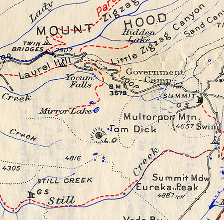
Because of its proximity, the lake shows up on the earliest maps of the Government Camp area, when the Mount Hood Loop Highway had a very rough, early alignment and was not yet a loop. The original Skyline Trail map (below) from the early 1900s shows Mirror Lake just west of the new trail, and a version of the early loop road before the Laurel Hill switchbacks were built.
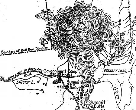
1920s-era map of Mount Hood and the Government Camp area
By the early 1920s, the effort to complete the loop highway was in full swing, including the graceful switchbacks that scaled Laurel Hill (below), the spot where Oregon Trail immigrants had to lower their wagons with ropes because of the steepness of the terrain. Surprisingly, a formal trail to Mirror Lake had not yet been constructed by this time.
1920s map of the first paved alignment of the Mount Hood Loop Highway at Government Camp
Other maps from the early 1900s (below) tell another story about Mirror Lake: it was within the northern extent of the Sherar Burn, a massive fire that had destroyed forests from the Salmon River to Camp Creek. As recently as the 1980s, bleached snags from the fire were standing throughout the Mirror Lake area.
1920s map showing the Sherar Burn extent in the Mirror Lake area
The Sherar Burn of the mid-1800s created vast tracts of huckleberries across the area, and during the early days of the highway, huckleberry pickers were a common sight, selling coffee cans of fresh berries to mountain visitors (below).
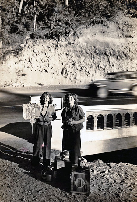
Huckleberry pickers in the 1930s at the Little Zigzag River bridge, below Laurel Hill
Mirror Lake, itself, looked quite different in the 1920s, too. Today’s tree-rimmed lake was mostly surrounded by burned snags and fields of beargrass and huckleberry in the 1920s (below).
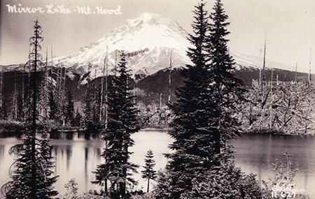
Mirror Lake in the late 1920s
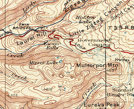
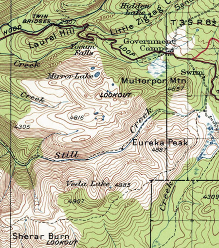
Sometime in the late 1920s or early 1930s, a new trail was constructed from the new highway to Mirror Lake. The trail began at a sharp turn on the old highway, traversing above the north shoulder of Yocum Falls on Camp Creek, crossing to the south side of the creek at the spot where the modern trailhead is located today (see maps below).
This lower section (from the bend in the old highway to the modern trailhead) of the original Mirror Lake trail was destroyed just 25 years later, when the modern highway grade cut through the area. This portion of the old highway still exists in this area, accessible from the Laurel Hill historic landmark pullout (currently closed because of the highway widening).
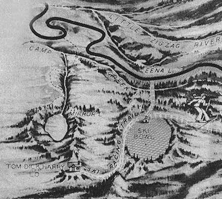
1930s map of the original Mirror Lake Trail
1930s map of the Mirror Lake Trail and surrounding area
When the original Mirror Lake Trail was built, the trailhead was located just a few yards beyond an impressive roadside viewpoint of Yocum Falls on Camp Creek (below). Today, the forest has recovered so completely in this part of the Sherar Burn that this viewpoint is completely overgrown. It is still possible to visit Yocum Falls from the old highway grade, though, by following rough use trails.
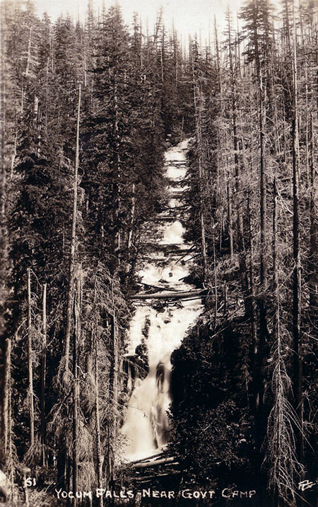
Yocum Falls as it once appeared from the original Mount Hood Loop Highway
The lower section of the original trail seems to have followed the rambling extent of Yocum Falls quite closely before the trail was destroyed by the modern highway. While the current trailhead gives a brief glimpse of the top of the falls, the old route seems to have provided a nice view of the falls since lost (more on this topic in the third part in this series).
Today, the modern Mirror Lake trailhead continues to provide a popular drop-in hike for families and casual hikers, but the convenience comes at a price. The shoulder parking area is large enough to allow up to 100 cars, and on busy weekends, still more hikers park along the highway all the way to Government Camp, walking the highway shoulder to reach the trailhead.
The Mirror Lake Trail was never designed to handle this much traffic, nor is the small lake able to handle so many visitors. These concerns are part of the Forest Service thinking in why a new trailhead should be constructed.
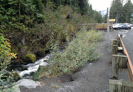
Camp Creek suffers from its close, unprotected proximity to Highway 26 and the Mirror Lake Trail parking.
Meanwhile, the 1950s-era trailhead pullout in use today was built at a time when little thought was given to environmental impacts. As a result, highway fill was pushed to the edge of Camp Creek, exposing an important salmon and steelhead stream to heavy loads of silt and pollution from parked vehicles. A visit to Yocum Falls, just downstream, reveals a troubling amount of road debris and the sharp odor of pollution in an otherwise healthy stream corridor.
While these growing impacts on Mirror Lake and Camp Creek aren’t the reason ODOT gives for closing the current Mirror Lake Trailhead, they are compelling arguments to consider.
____________
The next part of this 3-part series will take a closer look at ODOT’s arguments for closing the existing trailhead and the Forest Service proposal for a new trailhead located east of the existing access.

Tom, thanks for all the hard work you put into this blog! I really look forward to each installment.
Can you tell us what year the Sherar Burn happened? As a young boy (~1960) I remember my Dad pointing out the snags in Camp Creek as we made our way up over US26.
LikeLike
Thank you, Jerry! And yes, I was planning to dig into that and update the article to be more specific, so thanks for the reminder! According to Lewis McArthur, the Sherar Burn was “one of the big fires of the middle 19th Century. It went to grass, and Joseph Sherar grazed sheep there before it became a national forest.” That would be the same Sherar of the falls and bridge on the Deschutes, again, according to McArthur. Thanks for asking!
Tom
LikeLike