Proposal: Historic Mount Hood Loop State Trail (Part 1 of 2)

Description: Macintosh HD:Users:Tom:Desktop:20xxxx Mount Hood Loop Part 1:HoodLoopPartOne01LaurelHillCar1920s.jpg
1920s traveler admiring the view from Laurel Hill on the brand new Mount Hood Loop Highway

The year is 2035, and a family of tourists is just arriving at a local bed and breakfast in the village of Brightwood, Oregon, along the old Mount Hood Loop highway. They have just traveled 45 miles from Portland International Airport to Brightwood on the first of a six-day, world-class cycling tour of Mount Hood and the Columbia River Gorge.

On the first day of their tour they followed quiet country roads through the beautiful farms and picturesque pastures of the lower Sandy River Valley. Mount Hood floated on the horizon for much of their ride, hinting at the sights to come. After a night in Brightwood, the family will continue on to the village of Rhododendron, where the newly completed Historic Mount Hood Loop (HMHL) State Trail begins a spectacular tour of some of Oregon’s finest scenery.

Description: Macintosh HD:Users:Tom:Desktop:20xxxx Mount Hood Loop Part 1:HoodLoopPartOne02LittleZigzagBridge1937.jpg
Selling huckleberries at the just-opened Little Zigzag Bridge on the loop highway in the 1920s

Inspired by the recently completed Historic Columbia River Highway (HCRH) State Trail, this new trail follows once forgotten or abandoned segments of the historic Mount Hood Loop highway, with new connecting segments completing the route through mossy rainforests, alpine meadows and along mountain streams. Most of the new trail is far from the traffic, noise and hazards of the modern highway corridor, taking visitors back in time and pace of what it was like to experience the original loop highway more than a century ago.

A few miles up the new route, at the Little Zigzag River, the family parks their bikes for a short hike to a shady waterfall. Next, they will climb Laurel Hill along restored sections of the original highway, where route passes the nearly 200-year old ruts from covered wagons on the Oregon Trail that can still be seen. Their next stop is in Government Camp for lunch, with a visit to the Mount Hood Cultural Center and Museum.

Description: Macintosh HD:Users:Tom:Desktop:20xxxx Mount Hood Loop Part 1:HoodLoopPartOne03LittleZigzagBend1920s.jpg
Mount Hood Loop Highway construction in the early 1920s at the Little Zigzag Bridge

From Government Camp, their tour descends past Summit Meadows to iconic Trillium Lake, then heads east to the White River and Hood River Meadows. At Sherwood Campground they reach the east end of the new HMHL State Trail, and park their bicycles for the night. Here, they will stay in one of the well-stocked Forest Service yurts that overlook the East Fork Hood River. After a light dinner, the family hikes the easy trail to nearby Tamanawas Falls to cap a specular day on the mountain.

On their third day, the family begins a scenic descent along the Mount Hood Loop into the orchards of the Hood River Valley, stopping in the village of Parkdale for lunch and at roadside fruit stands along the way. They arrive in the town of Hood River by late afternoon, with plenty of time to explore the town’s galleries, shops and restaurants before checking in to the historic Hood River Hotel for the third night of their tour. 

The once (and future!) tunnel with windows at Mitchell Point

From Hood River, the family spends their fourth day on the spectacular, world-famous HCRH State Trail, traveling west through the newly restored Mitchell Point Tunnel and a stop at the short, new viewpoint hike to Viento Bluffs. A bicycle-friendly hotel in Cascade Locks serves as their base for a longer, late afternoon hike along the scenic Pacific Crest Trail.

On the fifth day of their circuit, the family continues their tour on the HCRH State Trail from Cascade Locks to the west trailhead at Ainsworth State Park, where they follow the Historic Columbia River Highway west to Multnomah Falls for lunch and another short hike to the iconic Benson Bridge. Finally, they make the climb past Crown Point and then down to their final night at a Troutdale bed and breakfast, located along the Sandy River. 

From Troutdale, the family will return to PDX and a flight home after their memorable six-day, 155-mile journey along the old Mount Hood Loop — no car required!

________________

In this two-part article, we’ll explore some long-forgotten sections of the old Mount Hood Loop highway, and the potential for bringing them back to life in the same way that abandoned sections of the old Columbia River Highway have been reclaimed. But does restoring the historic Mount Hood Loop Highway as a state trail make sense?

Yes, if you consider that bicycle tourism contributes $83 billion annually to U.S. economy, according to a 2017 study by the Outdoor Industry Association. Or that bicycle tourism in Oregon brings more than $400 million to our state economy, according to a 2012 study by Travel Oregon. And studies also show that touring cyclists tend to be older, wealthier and spend more when they travel, making them a coveted market in tourism.

Bicycle touring on Grand Canyon’s car-free South Rim (NPS)

Most importantly, these tourists don’t speed home after a day on the mountain to spend their money back in Portland. Instead, they invest in the local tourism economy along their multi-day tours, supporting the local lodging, restaurants, guides, museums and galleries that rely on tourist dollars to survive.

This article opened with a story about a future family traveling the 155-mile Mount Hood Loop over six days, but more ambitious riders could easily complete the loop in two or three days. Visitors with more time could easily spend a week or more exploring side trails and the towns along the loop, including a visit to historic Timberline Lodge.

Description: Macintosh HD:Users:Tom:Desktop:20xxxx Mount Hood Loop Part 1:HoodLoopPartOne09TouringMap.jpg
Bicycle touring options from bold to leisurely would be possible on the restored Mount Hood Loop.

The nearly completed HCRH State Trail has also shown that local cyclists and walkers use the route in day-segments, taking advantage of the many trailheads along the way to explore the trail in sections. Some of these day-use visitors are also looking for bike-and-hike adventures on foot trails that connect to the HCRH State Trail. A new HMHL State Trail could offer the same bike-and-hike opportunities, as well as winter skiing and snowshoeing.

The National Park Service is leading the way among our federal land agencies in both promoting bicycle tourism and in managing new forms of cycling — notably, e-bikes (electric bikes), which are now permitted in several parks where motorized travel is otherwise prohibited. Why permit e-bikes? Partly because of the explosive growth in e-bikes, but also because e-bikes allow more people to experience cycling. They have zero emissions and are nearly as quiet as non-electric bikes, so they are just as compatible in natural settings as conventional bikes. Because e-bikes are opening the sport of cycling to a much wider audience, they have only added to the demand for safe, scenic places to ride, and help make the case to go big in how we plan for trails in Oregon.

Description: Macintosh HD:Users:Tom:Desktop:20xxxx Mount Hood Loop Part 1:HoodLoopPartOne09HCRH.jpg
Touring on the Historic Columbia River Highway near Rowena Crest (Travel Oregon)

While Oregon has been at the forefront of promoting bicycle tourism, other states with the kind of scenery that draws national and international tourism are catching on, too. Montana now sees a half-million touring cyclists visit their state each year, and other states like Colorado and Vermont are also seeing the benefits of bicycle tourism to their small towns and rural economies.

Building on our Success in the Gorge

In 1986, a decades-long effort to restore abandoned sections of the Historic Columbia River Highway as a recreation trail began with this simple passage in the legislation that created the Columbia River National Scenic Area:

16 U.S.C. 544j Section 12. Old Columbia River Highway: The Oregon Department of Transportation shall, in consultation with the Secretary and the Commission, the State of Oregon and the counties and cities in which the Old Columbia River Highway is located, prepare a program and undertake efforts to preserve and restore the continuity and historic integrity of the remaining segments of the Old Columbia River Highway for public use as a Historic Road, including recreation trails to connect intact and usable segments.

This revolutionary provision recognized both the intrinsic value of preserving and celebrating the historic highway and the exponential growth in demand for recreation opportunities in our growing region. Both principles still apply today as the original vision for creating the HCRH State Trail nears completion. 

Description: Macintosh HD:Users:Tom:Desktop:20xxxx Mount Hood Loop Part 1:HoodLoopPartOne04HCRH2018.jpg
ODOT has gradually rebuilt a new trail in the style of Samuel Lancaster’s original design where modern freeway construction destroyed the historic Columbia River Scenic Highway.

With our proven success in saving and restoring the old highway in the Gorge, it’s the right time to look ahead toward a new vision of completing the larger Mount Hood Loop, as it once existed. Like the Columbia River Highway, the surviving historic highway segments on Mount Hood are at serious risk of being lost forever. Neither ODOT nor the Forest Service have any plans to “preserve and restore the continuity and historic integrity” of this remaining piece of the old Mount Hood Loop.

The Vision: Restoring the Mount Hood Loop Experience

Much of the original Mount Hood Loop Highway was abandoned or bypassed in the late 1950s, when the modern, “straightened” route we know today was constructed. 

Over the decades much of the “modern” road was incrementally widened from the original two lanes in the 1960s to four lanes in over the past two decades making it much more of a “freeway” than a “scenic highway”. Most recently, ODOT spent tens of millions to make our “scenic” highway even wider at Laurel Hill, near Government Camp, in order to add lanes and a freeway-style concrete median. 

Description: Macintosh HD:Users:Tom:Desktop:20xxxx Mount Hood Loop Part 1:HoodLoopPartOne05MirrorLakeWidening2014.jpg
No shortage of funding, here… ODOT just spent $37 million blasting away more of Laurel Hill in order to widen Highway 26 and add a freeway-style concrete median.

Today, drivers brave enough to pull off at the few pullouts that remain on US 26 are overwhelmed by the noise of speeding traffic and trucks. Few cyclists even consider making this scary trip, which means fewer touring cyclists to support the mountain economy.

The good news? Half-hidden under 60 years of moss and ferns, a series of historic bridges, stone fountains and other historic features still survive from the original loop highway, with spectacular roadside scenery that can’t be matched by the modern road. These historic features are mostly neglected, if not outright abandoned, and are waiting for a new vision to bring them back to life.

Description: Macintosh HD:Users:Tom:Desktop:20xxxx Mount Hood Loop Part 1:HoodLoopPartOne03LittleZigzagBridge.jpg
The old Little Zigzag Bridge survives under a century of moss. The huckleberry pickers pictured in the second photo in this article were standing just to the left of this view.

The template for saving these historic remnants and repurposing them to become part of a new recreation route would have seemed farfetched thirty years ago. Today, our newly restored HCRH State Trail not only serves as a perfect model for how to fund, design and build such a facility, it also reminds us that the Gorge trail is part of the larger vision, with the two trails connecting to trace the entire Mount Hood Loop of the 1920s.

Three Trail Sections

It turns out the entire route of the proposed HMHL State Trail falls along the Mount Hood National Scenic Byway corridor, a special highway designation extending from Troutdale to Hood River.

Description: Macintosh HD:Users:Tom:Desktop:19xxxx Mount Hood Loop Trail:ScenicByways.jpg

This is very good news as a starting point for restoring and reconnecting the old highway as part of the Mount Hood Loop. From a bureaucracy perspective, it means the route is already designated in a way that allows ODOT to spend money in the corridor on projects that make it safer and more scenic for visitors using any mode of travel. But if you read the scenic byway description, it’s pretty clear that bicycles are an afterthought. It doesn’t have to be that way.

For the purpose of this proposal, the Mount Hood National Scenic Byway route is the foundation for the trail concept that would restore and reconnect surviving historic sections of the original highway. Like the Historic Columbia River Highway corridor, the idea is to restore bypassed sections of the original highway to reconnect the other, surviving sections as a continuous route. 

This combination of existing and restored routes is organized into three sections that generally follow the existing Mount Hood National Scenic Byway corridor, beginning in Troutdale. The west and east sections are shared roads that mostly need better signage, while the middle, historic section would be a mix of shared roads and paved trails that follow restored highway segments connected by new trail segments. 

Here’s a description of each of the three segments of the Mount Hood National Scenic Byway, reimagined:

West Section – Troutdale to Rhododendron: The west leg of the route would follow much of the existing scenic byway from Troutdale to Sandy, traveling through the sprawling nurseries and berry fields of East Multnomah County. The current scenic byway route joins heavily traveled US 26 in Sandy, following the highway all the way to Mount Hood. It’s a noisy and dangerous route for anyone, but especially cyclists. Therefore, instead of joining US 26 there, the reimagined route would head in a different direction.

Description: Macintosh HD:Users:Tom:Desktop:20xxxx Mount Hood Loop Part 1:HoodLoopPartOne05MarriedWithBikes01.jpg
The terrifying ride along Mount Hood 26 makes this section of the Mount Hood Scenic Byway anything but scenic for cyclists (photo: Married with Bikes blog)

From Sandy, the new Mount Hood National Scenic Byway route would turn east to follow historic Marmot Road and Barlow Trail Road to the mountain community of Zigzag. From there, a short section of old highway along the Faubion Loop and a very short, protected bike path along US 26 would complete the connection to the Rhododendron community. 

Description: Macintosh HD:Users:Tom:Desktop:19xxxx Mount Hood Loop Trail:OR_MountHoodScenicBywayWestSection.jpg
Loop Highway State Trail Concept: West Section

This quiet, safer and more scenic alternative route is shown in dashed red on the above map. Along the way, visitors would travel through picturesque farmland with Mount Hood views and the forest communities of Marmot, Brightwood, Zigzag and Rhododendron. Several riverside parks and the Sandy Ridge mountain bike park are also located along this part of the route.

Design elements along this 37-mile segment would build on existing scenic byway guidelines, with improved way-finding and interpretive signs that would help cyclists and drivers more easily follow the loop and locate lodging and other services.

Historic Highway Section – Rhododendron to Sherwood Camp:This section is the main focus of the proposed Historic Mount Hood Loop State Trail and extends from Rhododendron to Sherwood Campground.This section includes several miles of bypassed and abandoned highway that have the potential to become a spectacular, world-class cycling experience. Today, many of these historic features are at risk, with no plans by ODOT or the Forest Service to protect them.

Description: Macintosh HD:Users:Tom:Desktop:20xxxx Mount Hood Loop Part 1:HoodLoopPartOne10Decommission2012.jpg
The Forest Service destroyed the original paved surface a half-mile section of the historic loop highway in 2012 for no particular reason. Fortunately, the roadbed was left intact.
Description: Macintosh HD:Users:Tom:Desktop:20xxxx Mount Hood Loop Part 1:HoodLoopPartOne11DecommissionGuy Meacham.JPG
Fans of the surviving sections of the old highway are out there! This sign was posted where the Forest Service destroyed the historic highway surface in the previous photo (Photo: Guy Meacham)

From Rhododendron, the section of the Mount Hood Loop route would follow a series of connecting multi-use trails that would combine with still-operating segments and long-abandoned secxtions of the old highway for the next 28 miles, traversing some of the most scenic places along the Mount Hood loop, all the while avoiding busy US 26.

Description: Macintosh HD:Users:Tom:Desktop:20xxxx Mount Hood Loop Part 1:HoodLoopPartOne12BywayHistoricSection.jpg
Loop Highway State Trail Concept: Historic Section

Along the way, the proposed route would pass several historic bridges, campgrounds, historic Government Camp and traces of the original Barlow Road that formed the final stretch of the Oregon Trail. There are many possible side trips along this historic section of the proposed loop, including the historic Timberline Lodge and several trailheads with bike-and-hike opportunities.

East Section – Sherwood Camp to Hood River: From the Sherwood Campground, the remaining 27 miles of the restoredMount Hood Loop would follow OR 35, a much less busy, two-lane highway with room for a shoulder bikeway. This section of the loop route would follow the same alignment as the Mount Hood National Scenic Byway, traversing some of Oregon’s most beautiful landscapes in the orchards and forests of the Hood River Valley.

Description: Macintosh HD:Users:Tom:Desktop:20xxxx Mount Hood Loop Part 1:HoodLoopPartOne13BywayEastSection.jpg
Loop Highway State Trail Concept: East Section

The east section ends at the town of Hood River, which lies at the mid-point of the HCRH State Trail. The 51-mile return route to Troutdale begins here, and traverses the exceptional scenery of the western Columbia River Gorge, including Multnomah Falls and Crown Point.

Through some miracle, this original fountain that once graced the old highway survives nearly a century later at Sherwood Camp, just a few feet from the modern highway. This is just one of many historic traces of the old route that have survived and call out for a new vision to protect and restore them.

There is no shortage of scenery along the Mount Hood Loop, but many visitors who come today are surprised and disappointed by the lack of pullouts, interpretive signs and heavy highway and winter ski resort traffic that makes it all but impossible to enjoy the modern highway. 

Can we reimagine the Mount Hood National Scenic Byway to provide a better alternative to the rush of the modern highways by restoring the surviving segments of the historic highway? Our experience in the Gorge says yes, and the old Mount Hood Loop could join the Gorge as a world-class touring destination. But what would it take to get there?

________________

Next up in Part 2: how we get there, including a virtual tour the surviving sections of the historic Mount Hood Loop Highway and the opportunities for restoring this exceptionally scenic old road as a state trail.

Kohnstamm Memorial Trail?

Entering the Kohnstamm Memorial Wilderness

When President Barack Obama signed the Omnibus Public Lands Management Act of 2009 into law on March 30, 2009, more than a dozen new pocket wilderness areas and additions to existing wilderness were created around Mount Hood and in the Clackamas watershed. 

Among these, the Richard L. Kohnstamm Memorial Area expanded the Mount Hood Wilderness to the east of Timberline Lodge to encompass the White River canyon, extending from Mount Hood’s crater to about the 5,000 foot level, including a segment of the Timberline Trail and Pacific Crest Trail that traverses the canyon. This wilderness addition was created to “recognize the balance between wild and developed areas in the national public lands system and to create a tribute to the man who saved Timberline Lodge.”

The wilder side of the Timberline area is now the Kohnstamm Memorial Area, an extension of the Mount Hood Wilderness just east of the lodge

Richard Kohnstamm was the longtime force behind the RLK Company, operators of the Timberline Resort, which has a permit to operate the historic Timberline Lodge, which in turn is owned by the American public. 

After his duty as a gunner during World War II, Kohnstamm returned home to earn his masters degree in social work from Columbia University. After college, he moved to Portland to take a job at a local social services non-profit. Soon after arriving here, he made a visit to Timberline Lodge, where he was immediately taken with the beauty of the massive building. 

Richard Kohnstamm at Timberline in 1957 (Oregon Encyclopedia)

But Kohnstamm saw a tarnished jewel, as the lodge had quickly fallen into disrepair following its construction by the Works Progress Administration in 1937. The Forest Service had revoked the operating permit for the lodge and was looking for a new operator, and so began the Kohnstamm era at Timberline. By all accounts, he did, indeed, save the lodge. 

Kohnstamm soon teamed with John Mills to found the Friends of Timberline, a non-profit dedicated to preservation of the history, art and architecture of the remarkable building. The unique partnership between the Forest Service, Friends of Timberline and the RLK Company to preserve the lodge in perpetuity continues to this day, and is known as the Timberline Triumvirate. 

Today, the lodge continues to thrive, and summer resort operations have now expanded to include a controversial bike park centered on the Jeff Flood chairlift. After years of legal challenges, the RLK Company build miles of bicycle trails descending from main lodge to the base of the lift, where cyclists can load themselves and their bikes for a quick ride back to the top. 

The Timberline Resort’s new bike park opened this summer (photo: Timberline)

It’s a high-adrenaline activity made easy, with no hills to climb. But the development of this new attraction underscored the fact that the Timberline resort operators and Forest Service have done little over the decades to enhance the hiking experience around the lodge, despite plenty of demand. 

The reason is pretty obvious: hikers don’t buy lift tickets. Yes, some hikers help fill the hotel rooms in summer, and still more stop by to support the restaurants in the lodge, but filling ski lifts continues to the focus at Timberline.

Bikes riding the Jeff Flood lift back to the lodge (photo: Timberline)

Today, hikers at Timberline are limited to walking along the Timberline Trail or hiking the Mountaineer Trail, a semi-loop that climbs to a lift terminal, where it dead-ends at a dirt service road. Hikers usually follow the steep, dusty road back to lodge to complete a loop.

But perhaps the Richard L Kohnstamm Memorial Area could be inspiration for the Forest Service and RLK Company to bring new trails to the area, and a create a more welcoming trailhead for visitors who aren’t staying at the lodging or paying to ride the resort lifts? In that spirit, the following is a concept for a new trail that would be an instant classic on the mountain, rivaled only by the popular Cooper Spur Trail on Mount Hood’s north side for elevation and close-up looks into an active glacier.

Proposal: Kohnstamm Glacier View Trail

The proposed Glacier View Trail would climb the broad ridge that separates the White River and Salmon River canyons, just east of Timberline Lodge. The new trail would begin just across the Salmon River from the lodge, at a junction along the Timberline Trail, and end at Glacier View, a scenic high point on the ridge between the Palmer and White River glaciers. 

This viewpoint is already visited by a few intrepid explorers each year for its spectacular views into Mount Hood’s crater and the rugged crevasses of the White River Glacier. The schematic below shows how the new route would appear from Timberline Lodge:

(click image to enlarge)

Another perspective (below) of the proposed trail shows the route as it would appear from further east along the Timberline Trail, where it travels along the rim of White River canyon. This angle also shows the tumbling descent of the White River Glacier and the steep west wall of the canyon that would provide several overlooks from the new trail:

(click image to enlarge)

Thanks to the gentle, open terrain, the new trail would climb in broad, graded switchbacks, eventually reaching an elevation of 8,200 feet. This is just shy of the elevation of Cooper Spur, and would make the Kohnstamm Glacier View Trail the second-highest trail on the mountain.

The viewpoint at Glacier View (below) is already marked by a stone windbreak built by hikers that complements several handy boulders (below) to make this a fine spot for relaxing and taking in the view.

End of the trail at Glacier View (photo: Google)

From the Glacier View viewpoint, Mount Hood’s crater and the upper reaches of the White River Glacier (below) are surprisingly rugged and impressive, given the generally gentle terrain of Mount Hood’s south side. From this perspective, the Steel Cliffs and Crater Rock dominate the view as they tower over the glacier.

Mount Hood’s crater and the upper reach of the White River Glacier from Glacier View (photo: Google)
White River Glacier from Glacier View (photo: Google)

But the scene-stealer is the White River Glacier, which stair-steps down a series of icefalls directly in front of Glacier View (below), providing a close-up look into the workings of an active glacier. Lucky hikers might even hear the glacier occasionally moving from this close-up perspective as it grinds its way down the mountain.

Crevasses in the White River Glacier below Glacier View (photo: Google)

The view to the south from Glacier View (below) features the long, crevasse-fractured lower reaches of the White River Glacier, and below, the maze of sandy ravines which make up the sprawling White River Canyon. The deserts of Eastern Oregon are on the east (left) horizon from this perspective, and the Oregon Cascades spread out to the south.

The view down the White River Canyon from Glacier View (photo: Google)

The hike to Glacier View from Timberilne Lodge on the proposed Kohnstamm Trail would be about 2.5 miles long, climbing about 2,300 feet along the way, and would undoubtedly become a marquee hike on the mountain, if similar trails like Cooper Spur and McNeil Point are any gauge. But the backlog of trail needs at Timberline extend beyond having a marquee viewpoint hike like this. 

The Kohnstamm trail concept therefore includes other trail improvements in the Timberline area that would round out the trail system here. The following schematic (below) include building a new 1.4 mile trail from the upper stub of the Mountaineer Trail to Timberline Lodge, allowing hikers to complete the popular loop without walking the dusty, somewhat miserable service road below Silcox hut, often dodging resort vehicles along the way.

(click image to enlarge)

The broader Kohnstamm trail concept also calls for using the east parking area as a day-hiking hub in the summer months, with clearly marked trailheads that would consolidate the maze of confusing user trails that are increasingly carving up the wildflower meadows here. The new hub would also include restrooms, interpretive displays, picnic tables and other hiker amenities that would make for a better hiking experience.

Time for a makeover? Abandoned lift terminal at the proposed trail hub

A more ambitious element of the concept is to convert the neglected bones of an abandoned lodge structure (above) at the east parking area to become a hiker’s hut where visitors could relax after a hike, fill water bottles or learn about hiking options from Mount Hood’s volunteer trail ambassadors. 

This element might even tempt the Timberline resort operators to help make these trail concepts a reality if it offered an opportunity to provide concessions to hikers. After all, hiking is the fastest growing activity on the mountain (and on public lands), not skiing (or even mountain biking). Creating a hiking hub could be an opportunity for the Timberline operators to evolve their future vision for the resort to better match what people are coming to the mountain for.

What would it take?

Trail building is typically heavy work that involves clearing vegetation and building a smooth tread where rocks and roots are the rule. But the proposed Kohnstamm Trail would be very different, as the entire route is above the tree line and would be on the loose volcanic debris that makes up the smooth south side of Mount Hood. Trail building here would be much simpler, from the ease of surveying without trees and vegetation to get in the way, to actual trail construction in the soft soil surface. For these reasons, much of this work would be ideal for volunteers to help with.

In reality, the greatest obstacles to realizing this concept would likely be regulatory. Convincing the Forest Service to permit a new trail would be a tall hurdle, in itself. But if the Timberline resort operators were behind the idea, it would almost certainly be approved, especially if the resort embraced building and maintaining the trail hub improvements. Who knows, maybe they will even spot this article..?

Author’s Confessions…

As a postscript, I thought I’d post a few confessions from days of yore. I grew up in Portland and began skiing at Timberline Lodge as a tiny tot. I continued to avidly ski at the Mount Hood resorts for many years until giving up alpine skiing in the early 90s, largely in response to the expansion of the Meadows resort into lovely Heather Canyon, a deal-breaker for me. I loved the sport, but saw the beauty of the mountain under continual threat from the resort operations — and still do. Today, I make due with snow shoes and occasional trips on Nordic skis, though I do miss the thrill of alpine skiing!

The author skiing Timberline in 1978

An earlier awakening for me came in 1978, with the construction of the Palmer Lift at Timberline. This lift completed Richard Kohnstamm’s vision for year-round skiing on the mountain. But it was the first lift on Mount Hood to climb that far above the tree line, and was an immediate eyesore. Sadly, the conversion of the Palmer Glacier to become plowed rectangle of salted snow (see “Stop Salting the Palmer Glacier!”) that can be seen for miles completed the travesty.

That Palmer Lift debacle was soon followed by an even more egregious lift at Mount Bachelor, one that I wrote about 37 years ago in this (ahem!) riveting bit of self-righteous student journalism! (below)

(click image to enlarge)

When I stumbled across this old clipping from my days as a columnist at the Oregon State University student newspaper, I initially winced at the creative flourishes (…hey, I was 20 years old!). But my sentiments about these lifts — and the Heather Canyon lift at Meadows — remain unchanged. They were a step too far, and represented a real failure of the Forest Service to protect the mountain from over-development.

That said, I do believe the ski resorts can be managed in a more sustainable way that doesn’t harm the mountain. We’re certainly not there yet, and because all three of the major resorts (Timberline, Ski Bowl and Meadows) all sit on public land, I believe we all have a right to help determine that more sustainable future. 

In this article, I’ve made a case for accommodating more than just lift ticket purchasers in the recreation vision at Timberline Lodge. In future articles I’ll make the case for rounding out the mission for the other resorts in a way that meets the broader interests of those of us who own the land.

Ski Traffic & the Loop Highway: Part 2

The winter weekend crush of skiers is nothing new on Mount Hood

The winter weekend crush of skiers is nothing new on Mount Hood

(This is the second in a two-part article. The first part focused on the latest plans to add more parking to the Meadows resort, another step in the wrong direction for Mount Hood, but one that (unfortunately) has already been approved by the U.S. Forest Service. This part focuses on the future, and a promising new strategy that seems to finally be turning the page on an era when ODOT and the Mount Hood ski resorts simply paved their way out of weekend traffic problems with more parking and wider highways.)
__________________

Since the early days of developed snow sports on Mount Hood in the 1920s, winter weekend traffic jams have been the norm. The cars have changed (and so has the highway, regrettably), but the same bottlenecks appear in pretty much the same spots, as thousands of Portlanders pour into the ski resorts over a few short winter weekends each year.

Intrepid auto tours reached Government Camp on dirt roads years before the loop highway was completed in the early 1920s

Intrepid auto tours reached Government Camp on dirt roads years before the loop highway was completed in the early 1920s

From the beginning, there have been overflow parking lots, ski buses, shuttles — even an aerial tram in the early 1950s known as the Skiway — all in an attempt to stem the weekend ski traffic.

In 2013, the Oregon Department of Transportation (ODOT), in partnership with the U.S. Forest Service, the Federal Highway Administration and Clackamas and Hood River county officials, kicked off yet another effort to address the winter traffic overload.

In the 1920s, Government Camp was the center of winter activity -- and overflowing with cars

In the 1920s, Government Camp was the center of winter activity — and overflowing with cars

While this is just the latest of several ODOT-led efforts over the years to better manage the Loop Highway, the draft Mount Hood Multimodal Transportation Plan (MHMTP) is the best effort yet. While still only a document full of recommendations, the new plan offers real promise that federal, state and local officials are now more serious about managing the relatively short season of ski traffic gridlock.

Timberline Lodge was overflowing with cars as soon as it opened in the late 1930s

Timberline Lodge was overflowing with cars as soon as it opened in the late 1930s

Instead of attempting to rebuild the entire highway corridor to meet the peak demands of ski resort traffic that occurs over a few weekends each year, the MHMTP focuses instead on low-cost, high-impact tools. This is a radical and positive change in mindset — even if the plan itself still has a few gaps.

The stakes are high when it comes to managing traffic on Mount Hood. The ski resorts have little incentive to do anything except ask the general public to cough up more tax dollars for ever-wider highways. After all, it’s a sweet deal for the resorts and skiers, alike: in Oregon, just one in 25 residents ski, so the subsidy for highway projects catering to ski traffic is enormous.

ODOT is currently seeking bids in the latest round of road widening, this time along the slopes of Laurel Hill in what will eventually total more than $60 million in state gas tax funding over the past decade to widen the Loop Highway from Brightwood to Government Camp.

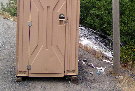
Camp Creek takes the brunt of trash and pollution from US 26. This scene is the unimproved roadside trailhead at Mirror Lake, where a chemical toilet (and associated trash) sits precariously above a steep bank dropping directly into the stream

Camp Creek takes the brunt of trash and pollution from US 26. This scene is the unimproved roadside trailhead at Mirror Lake, where a chemical toilet (and associated trash) sits precariously above a steep bank dropping directly into the stream

Just a few hundred yards downstream from the scene in the previous photo, Camp Creek spills over beautiful Yocum Falls, a seldom-visited spot bypassed by the modern highway. The pool below the falls is sullied with plastic cups, sport drink bottles and tires that have found their way into the stream from the highway

Just a few hundred yards downstream from the scene in the previous photo, Camp Creek spills over beautiful Yocum Falls, a seldom-visited spot bypassed by the modern highway. The pool below the falls is sullied with plastic cups, sport drink bottles and tires that have found their way into the stream from the highway

The traditional “building your way out” mindset has been bad for business in the local communities along the highway. The wider, noisier road has made it even less attractive for day tourists to risk a stop at the remaining shops and restaurants in the corridor. Worse, the huge 5-lane cross sections built on Highway 26 over the last decade have effectively cut the mountain villages in half by creating a scary barrier for local traffic to navigate, whether on foot, bicycle or in a vehicle.

Widening the Loop Highway is even worse for the natural environment, as highway trash, polluted runoff and blown gravel enters directly into the Salmon River, Still Creek, Camp Creek (pictured above) and the Zigzag River. All four streams serve as important salmon and steelhead habitat, a fact lost on the rush to make room for a few weekends of ski traffic each year.

A New Direction?

The Mount Hood Skiway was an early 1950s experiment to lessen parking pressure on Timberline Lodge - it failed, but may have been ahead of its time!

The Mount Hood Skiway was an early 1950s experiment to lessen parking pressure on Timberline Lodge – it failed, but may have been ahead of its time!

ODOT’s new MHMTP is both comprehensive and innovative. The plan is guided by the following objectives for how future travel should occur on the mountain:

• Improved highway safety for all users
• Expanded travel options year-round
• Reduced peak travel demand
• Enhanced mobility and access to recreation and local communities
• New projects should be financially feasible and sustainable
• New projects should be achievable in the next 15 years

The new focus on cost-effectiveness and a broader definition of desired outcomes beyond simply chasing traffic is new for ODOT — and for Mount Hood. It follows the lead of urban areas across the country, where cities are increasingly moving away from big-ticket road projects that seldom provide the advertised safety or mobility benefits used to justify them, and toward more practical solutions that have fewer unintended consequences.

A decade of futile "widening for safety" projects in the Highway 26 corridor has mostly resulted in dividing local communities and increasing highway runoff, with little traffic benefit

A decade of futile “widening for safety” projects in the Highway 26 corridor has mostly resulted in dividing local communities and increasing highway runoff, with little traffic benefit

To achieve these core objectives in managing the Mount Hood travel corridor, the MHMTP lays out four areas of proposed action – this is the real substance of the plan:

1. Better managing the system: in this area, the plan calls for another plan known as a “concept of operations”, which is transportation jargon for an operations blueprint for the Mount Hood loop from the City of Sandy to Hood River. Elements of an operations blueprint could range from web-based traveler information to new or upgraded electronic message signs along the highway, with real-time updates on traffic, parking, transit and emergencies.

The goal of this element of the MHMTP is to make the best use of the system through better-informed travelers and to better coordinate the various public agencies (ODOT, the Forest Service and the two counties) involved in operating the road system.

How it could be better: the details of the “concept for operations” aren’t nailed down at this point (thus the need for another plan), but one strategy not mentioned in the list of possibilities is variable speed limits along the entire loop. This key recommendation from ODOT’s 2010 Highway 26 Safety Audit deserves to be a priority above other, more costly highway projects already moving forward in the area. DOTs around the country are using this technology with excellent results in improving safety and traffic efficiency, and ODOT should join the movement.

An even larger gap in the strategy is an unwillingness by ODOT and the Forest Service to require the ski resorts to adopt peak pricing as a means to help spread out demand. The resorts are loathe to do this, given their troubled future (as described in Part 1 of this article), but if all three major resorts adopt the same policy, they will at least retain their current competitive positions with one another, while Mount Hood’s communities and environment would benefit from a coordinated effort to spread out the highway demand.

Not in the plan: pricing incentives for parking and lift tickets at the big three resorts to spread demand from weekend peaks

Not in the plan: pricing incentives for parking and lift tickets at the big three resorts to spread demand from weekend peaks

Sadly, it will be a very long time before the Forest Service asks the resort to adopt more aggressive peak pricing for lift tickets, but that is the best long-term solution available for spreading out ski demand. Short of that, ODOT holds the cards for managing parking, as all parking along the mountain portion of the Mount Hood Loop Highway falls within a state-designated SnoPark permit area.

Currently, ODOT charges a generic fee for annual and day passes to park at the SnoPark lots (including all three ski resorts), but the agency should consider using these permits to better manage demand on the highway. This is a very low-cost strategy to avoid some very high-cost road widening projects.

2. Bicycle and pedestrian projects: this much-needed element of the plan calls for improved bike and pedestrian crossings at key locations along the loop highway. Highway widening is also called for to allow for more shoulder space for bicycles, along with bike safety improvements at key intersections and traveler information for bicycles. While not driven by ski resorts, this element of the plan embraces the potential for Mount Hood to become a more balanced, year-round recreation destination, and the Loop Highway becoming less of a barrier to hikers and cyclists.

Notably, the famously crowded Mirror Lake trailhead is called out for relocation to address safety issues with the current trailhead. The new trailhead could be sited across the highway, accessed from an existing section of the Historic Mount Hood Loop Highway (that now serves the Glacier View SnoPark), and connected to the current trailhead with a new pedestrian bridge over US 26.

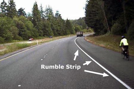
Rumble strips are very effective at keeping distracted drivers out of bike lanes, but bikes also need enough lane space to keep away from the rumble strip

Rumble strips are very effective at keeping distracted drivers out of bike lanes, but bikes also need enough lane space to keep away from the rumble strip

How it could be better: “widening” for bicycle lanes is a default recommendation that you might expect from ODOT, but the lanes along the Mount Hood loop are already very wide in many spots, so keep your fingers crossed that our highway planners are judicious about where to actually widen the road. In most cases, simply providing rumble strips along the shoulder stripe would go a long way to keep cycles safe from motor vehicle traffic, and require fewer subalpine trees to be cut for road widening.

A major gap in this element of the MHMTP is lack of policy direction on speeding or travel speeds — two of the three main contributors to serious accidents identified in the 2010 ODOT safety study (with winter conditions as the third).

Extending and enforcing the existing ODOT safety corridor and 45 mph speed limit from Rhododendron to the Hood River Meadows entrance to Mount Hood Meadows would make cycling along this most mountainous portion of the loop highway much safer – which in turn, makes cycling more attractive, especially on the lower sections of the loop that are generally snow free year-round.

"Widening for bicycle lanes" sounds easy, but the devil is in the details when the road travels through public forest lands

“Widening for bicycle lanes” sounds easy, but the devil is in the details when the road travels through public forest lands

3. Improved transit service: The MHMTP plan calls for new transit from Sandy to the mountain, and Clackamas County recently received a US Department of Transportation grant to expand its Mount Hood Express bus service from Sandy to Ski Bowl, Government Camp and Timberline Lodge. Rides are $2 each direction, with ten buses daily during the ski season, seven in the off-season. The trip from Sandy to Government Camp takes about 55 minutes and Timberline Lodge at about 75 minutes, so quite competitive with driving times and much less expensive.

It’s a good start, and long overdue. The fact that almost all traffic heading to the mountain during the winter season is destined for Government Camp, Timberline or Meadows makes the Mount Hood area highly serviceable with transit, provided a long-term funding mechanism can be found.

For too long, a very limited supply of shuttles and private ski buses at the Mount Hood resorts have been the sole transit option along the loop highway

For too long, a very limited supply of shuttles and private ski buses at the Mount Hood resorts have been the sole transit option along the loop highway

How it could be better: The proposed transit service in the MHMTP is great if you’re coming from Sandy — or able to drive and park your car there — but it doesn’t allow for truly car-free trips to the mountain in a region that is increasingly interested in having this option.

For years, people have wondered aloud about “extending MAX to the mountain”, but that will never happen — the cost would be astronomical and the ridership on the best of days wouldn’t come close to justifying the cost. But bus transit is completely within reach, and well-suited to the demand.

A proposal called “The Boot Loop” on this blog showed how it could be done — save for public and private interests along the loop highway coming together to make it happen. Let’s hope the Mountain Express pilot project is just the beginning of a more comprehensive transit system on Mount Hood and in the Gorge.

4. Safety projects: several critiques of ODOT’s ill-conceived “widening for safety” campaign along the Mount Hood loop have appeared in this blog over the past few years, and thankfully, some of the worst elements of the most recent phase between Rhododendron and Government Camp have been dropped.

Most recently, ODOT failed to receive construction bids within its project budget for this latest phase, and that is potentially good news if it means that some of the remaining bloated, environmentally destructive elements of the project (like cutting back cliffs on Laurel Hill) are scaled back.

Given this context, the safety projects contained in the MHMTP plan are refreshingly sensible and practice — truly “safety” projects, and not just an old-school highway widening agenda wrapped in an attractuve safety package.

ODOT owes the rural communities (like Rhododendron, above) along the loop highway retrofits to undo the damage from the "widening for safety"

ODOT owes the rural communities (like Rhododendron, above) along the loop highway retrofits to undo the damage from the “widening for safety”

How it could be better: travel speed is the single most important lever for highway engineers to reach for if improved safety is truly the desired outcome. ODOT was bold and forward-thinking when it adopted a safety corridor along a portion of Highway 26 several years ago, and especially when the agency adopted a 45 mph speed limit from Wildwood to Rhododendron.

There’s no reason why this successful strategy can’t be extended for the remainder of the ski commute along the Loop Highway, to the lower entrance at Mount Hood Meadows. As the 2010 ODOT safety audit clearly showed, nearly ALL of the serious accidents in this corridor were directly tied to heavy winter travel, and especially weekends, when the predictable crush of day skiers descends upon the mountain.

What’s Next?

ODOT will be wrapping up the MHMTP shortly. You can track the final recommendations on their project website:

Mount Hood Multimodal Transportation Plan website

As the MHMTP moves forward toward funding, the focus will shift to Clackamas and Hood River counties, the Forest Service, ODOT and the ski resorts working collaboratively to bring the various strategies completion. The plan sets forth three tiers of project, but all recommendations fall within a (relatively) short window of 15 years.

The Mirror Lake trailhead could see big changes under the proposed MHMTP plan

The Mirror Lake trailhead could see big changes under the proposed MHMTP plan

ODOT has an institutional habit of saying it “owns” the highways, but in fact, the public owns it – that’s us! Thus, it falls upon the true owners of the Loop Highway to track the details — the specific projects that will carry out the new direction called for in the MHMTP. Perhaps more importantly, it falls upon us to speak out against more funding of old-school road widening projects cloaked as “safety improvements” that could effectively cancel out the MHMTP proposals.

Over the next few years, the recommendations in the MHMTP will gradually be funded through ODOT’s statewide transportation improvement program and similar capital funding programs at the local level. Watch this blog for more details on how the dollars actually roll out in coming years on our beloved loop highway!

White River Buried Forest

The summer of 2011 will be remembered as the year of the Dollar Lake Fire in the Mount Hood area, as much of the north side is still smoldering from a lightning-caused wildfire that ignited on August 26. Though a calamity to those who loved the verdant forests on Mount Hood’s northern slopes, the fire is a blip on the screen when compared to the many explosive events that have rearranged the mountain’s forests and topography over the millennia.

Among the most recent and fascinating of these events are the Old Maid eruptions. These explosions knocked over entire forests on the mountain’s south side like matchsticks, burying them under a deep layer of ash and volcanic debris. This article describes the Old Maid events, and how to see traces of their aftermath today.

The Old Maid Eruptions

While most tourists at Timberline Lodge on a given day are blissfully unaware that Mount Hood is living volcano, the occasional, heady odor of sulfur fumes blowing down from the crater are a reminder the “quiet” spell we are enjoying is only temporary.

[click here for a larger version]

In geologic terms, the Old Maid eruptions are incredibly recent, finally winding down in our recorded history of the early 1800s. The events are named for Old Maid Flats, the debris plain created by the eruptions in the Sandy River canyon, though the impact on the mountain was much broader.

Scientists have determined the Old Maid eruptive period to have occurred within from about 1760 to 1810 A.D. In fact, when Lewis & Clark described the shallow “quicksand” delta of the Sandy River in 1804-05, they were looking at volcanic sediments that had only recently flooded down the river from the active slopes Mount Hood.

The former floor of the White River canyon is visible as a thin layer of oxidized soil, dotted with mummified trees.

The scientific accuracy of these dates is made possible by thousands of mummified trees swept over by the Old Maid debris flows, and later exposed by streams cutting into the sediments. The White River buried forest is one of the more prominent locations where these flattened forests and the former valley floor can plainly be seen.

The Old Maid eruptions originated in the modern crater of Mount Hood, where sulfur fumes still rise from the vents known as the Devils Kitchen. The massive, 800-foot volcanic dome of Crater Rock, itself, is just 200 years old and formed during these eruptions. The heat of rising magma in the crater eventually sent pyroclastic flows down the Sandy and White River canyons — rolling clouds of super-heated ash and debris that buried the entire landscape.

A closer look at the buried valley floor reveals mummified trees.

The Old Maid eruptions deposited about one hundred feet of debris throughout the upper White River canyon, filling the formerly U-shaped glacial valley with a flat fan of volcanic boulders, cobbles and fine ash. The outflow from the White River Glacier has since carved deeply into the debris flow, revealing the old valley floor and some of the thousands of mummified trees knocked over by the Old Maid event.

A flat-topped ridge in the middle of the White River canyon known as Mesa Terrace (see earlier schematic) is a remnant of the debris flow that shows the original depth of the debris above the valley floor.

Close-up of an entire tree, tipped over and buried where it fell on the former valley floor.

Two types of debris flow swept down the southern slopes of Mount Hood during the Old Maid eruptions. The most destructive were the pyroclastic flows, which many of us are familiar with from the colossal Mount St. Helens eruption of May 18, 1980.

In addition to the hot pyroclastic flows, cooler mudflows from flash-melted glaciers and snowfields also swept down Mount Hood’s south slopes during the Old Maid events. We know the buried forests at the bottom of White River Canyon fell victim to these mudflows, as pyroclastic flows would have instantly incinerated the standing timber. Instead, the cooler debris flows simply knocked the forests over, and buried them under layers of mud and debris.

Scientists believe these trees were partially buried, then broken off by subsequent flows.

Scientists believe the old valley floor now being revealed by erosion was of glacial origin, dating back to the last major glacial advance of the White River Glacier some 10,000 years ago. Thus, forests grew undisturbed along the former valley floor of the White River for a very long time.

Hiking to the Overlook

Hiking to the White River buried forest overlook is easy and scenic, as well as historic and iconic: it follows Mount Hood’s famous Timberline Trail for 0.7 miles to the impressive rim of the White River canyon. This section of trail also serves as the Pacific Crest Trail, the 2,000-mile epic trek from Mexico to Canada.

To find the trailhead, park in the lower, overflow lot located to the east of Timberline Lodge. Park near a gated dirt on the west side of the parking area. Follow this old road steeply uphill for about 200 yards to an obvious junction with the Timberline Trail, and turn right (or, if you’re coming from the lodge, follow any of the trails beyond the lodge uphill to the Timberline Trail and turn right). The Timberline Trail quickly traverses into a side-canyon, crossing the headwaters of the Salmon River.

Next, the Timberline Trail rambles across pumice-covered slopes and soon reaches a sign marking the Richard L. Kohnstamm Wilderness, created in 2009 as an addition to the wilderness complex that encircles Mount Hood. Kohnstamm was the resort operator responsible for resurrecting a struggling Timberline Lodge in the 1950s, and setting the resort on the successful path that it continues to enjoy today.

[click here for a larger, printable map]

Beyond the wilderness boundary, the trail descends across another pumice slope, then drops more steeply on a surface of loose glacial till as it traces the west moraine of the White River canyon. Soon, you will reach the overlook where the Timberline Trail follows the moraine crest, and arrives at a stand of trees. This is a good spot to stop and take in the scenery, and especially to pick out the signs of the buried forest, at the bottom of the canyon, below.

The south-facing slopes and open terrain can make this a hot, dusty hike in late summer, so be sure to carry water. You will also want a pair of binoculars to view the buried forest details more closely. If you have the time and energy after visiting the buried forest overlook, you can retrace your step to the dirt access road, then turn right and follow it to Silcox Hut, about 0.8 miles from the trailhead. The hut was the original upper terminal for the first Magic Mile ski lift in the late 1930s, and today is maintained as an historic structure.

Building the Timberline Trail

The McNeil Point Shelter.

For decades, hikers and backpackers have taken Mount Hood’s famous Timberline Trail for granted — and why not? It was one of the earliest alpine hiking trails in the American West, and seems to have evolved with the mountain itself.

But the story of the trail is one of an original vision that has been realized in fits and starts, and the story is still unfolding.

The first recreational trail on Mount Hood followed the South Eliot Moraine from Cloud Cap Inn to Cooper Spur, as shown on this 1911 map.

The first modern trail on Mount Hood was established in 1885, beginning at David Rose Cooper’s tent camp hotel, located near the present-day Cloud Cap Inn. The route followed the south Eliot Moraine to his namesake Cooper Spur. Soon thereafter, the Langille family would lead hikes and climbs on this route from the new Cloud Cap Inn, completed in 1889.

The Langilles also established a route from Cloud Cap to Elk Cove for their visitors, completing another section of what would someday become the Timberline Trail.

Hikers climbing toward Cooper Spur along one of the original sections of the Timberline Trail.

The route remains a popular trail, today, though it has never been formally adopted or maintained by the Forest Service. The first leg of this trail briefly functioned as a segment of the Timberline Trail, thanks to a temporary re-routing in the mid-2000s (more about that, later).

The significance of the original Cooper Spur trail is that it was built entirely for recreational purposes, the first such route on the mountain.

Camp Blossom was built some fifty years before Timberline Lodge was opened in 1938, but established the same network of trails that have since served the lodge.

Other hiking routes soon followed on the south side of the mountain, connecting the former Camp Blossom to nearby Paradise Park and the White River canyon. Camp Blossom was built by a “Judge Blossom” in 1888 to cater to tourists. The camp was at the end of a new wagon road from Government Camp, and located near present-day Timberline Lodge. It was eventually replaced by the Timberline Cabin (1916), and later, Timberline Lodge (1938).

The informal network of alpine trails radiating from Camp Blossom in the late 1800s still forms the framework of trails we use today. This is especially true for the nearly 7 miles of trail from White River to Paradise Park, which largely defined the Timberline Trail alignment in this section.

By the 1920s, the Langille family had developed trails from their Cloud Cap Inn to nearby Elk Cove (1924 USGS map).

By the 1920s, the Mazamas and other local outdoor clubs were pushing for more recreation facilities around the mountain, and public interest in a round-the-mountain trail was growing.

By this time, new Forest Service trails had been built on the north side of the mountain from the Clear Branch valley to Elk Cove and along Vista Ridge to WyEast Basin. These trails were connected at timberline (with a spur to Dollar Lake), creating another segment of what was to become the Timberline Trail. Combined with the route from Cloud Cap to Elk Cove, nearly 8 miles of the future Timberline Trail had been built on the north side of the mountain by the 1920s.

By the 1920s, the Vista Ridge and Elk Cove trails were established, extending the emerging Timberline Trail from Cloud Cap to Eden Park (1924 USGS map).

The Timberline Trail is Born

The concept of a complete loop around the mountain finally came together in the 1930s, during the depths of the Great Depression, when Franklin Delano Roosevelt’s New Deal recovery program, and the Civilian Conservation Corps (CCC), brought the needed manpower and financial resources to the project.

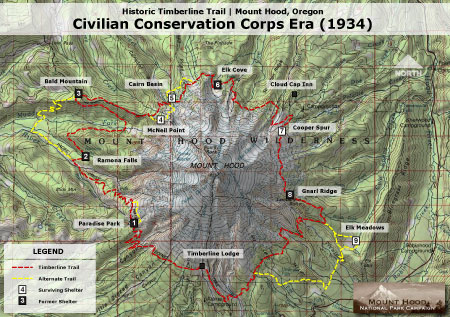
The CCC completed the new 37.6 mile Timberline Trail in 1934, stitching together the existing north side and south side trails, and covering completely new terrain on the remote west and east sides of the mountain.

The venerable Cooper Spur shelter still stands on the slopes above Cloud Cap, maintained by volunteers.

The Corps built a generous tread for the time in anticipation of heavy recreation use. The new trail was built 4 feet wide in forested areas, 2 feet wide in open terrain, and gently graded for easy hiking.

The trail was marked by square cedar posts placed at rectangular intervals over open country and by blazes in forested areas. Many of the distinctive trail posts survive between Cloud Cap and Gnarl Ridge, mounted in huge cairns.

Shelters were built along the trail by the CCC crews as a place for hikers to camp and rest, and as protection against sudden storms. Most are of the same stone design, with a small fireplace and chimney. They were built with steel rafters instead of wood so that the structures, themselves, would not be used as firewood in the treeless high country, and also to withstand heavy winter snows. Of the six original stone structures, only those at McNeil Point, Cairn Basin and Cooper Spur survive (see large version of map, below).

Map of the completed Timberline Trail and CCC era shelters.

(Click here for a large map)

Three wood structures were also built along lower sections of trail, at Ramona Falls, Bald Mountain and Elk Meadows. Of the three, only the rapidly deteriorating structure at Elk Meadows survives.

The completed trail featured a couple of oddities: the McNeil Point shelter had been constructed on a high bluff above the Muddy Fork that was eventually left off the final trail alignment, due to concerns about maintaining the trail at this elevation. Today, thousands of hikers nevertheless use the partially completed trail each year to reach the historic shelter and spectacular viewpoint.

Curiously, the shelter at Elk Meadows was also built off the main loop, perhaps because at the time, the meadows were seen as much a place to graze packhorses as for their scenic value. Like McNeil Point, this “forgotten” shelter continues to be a very popular stop for hikers, today.

This 1921 map shows the Oregon Skyline Trail terminating at Mount Hood, before construction of the Timberline Trail. Note the early Bull Run Reserve encompassing the entire west side of the mountain.

By the late 1930s, much of the new Timberline Trail had also been designated as an extension of the Oregon Skyline Trail — according to maps from the time (above), the Skyline had previously terminated on the slopes of Mount Hood, above Government Camp.

The expanded Skyline Trail arrived at the Timberline Trail from the south, near Timberline Lodge, turned east and traced the new Timberline Trail counter-clockwise around the mountain before descending to Lolo Pass, then headed north to Lost Lake and the Columbia Gorge.

1970s Trail Renaissance

A third major era of trail construction on the mountain came in the 1960s and 1970s, when several major re-routes of the Timberline Trail were built.

By the early 1960s, the Oregon Skyline Trail had been relocated to the west side of the mountain, following the Timberline Trail from Timberline Lodge north to the Bald Mountain Shelter, then on to Lolo Pass.

By the time the Pacific Crest Trail was established in the 1968 National Trails Act, absorbing the old Skyline Trail, a new route across the Muddy Fork canyon was in the works for the Timberline Trail.

The Cairn Basin stone shelter is the best-preserved of the CCC-era structures, thanks to more protection from the elements than most of the original buildings.

By the early 1970s, this new section rounded Yocum Ridge from Ramona Falls, crossed both branches of the Muddy Fork, then ascended to the steep meadows of Bald Mountain, one of the most popular Timberline Trail destinations today.

The new Muddy Fork segment is now part of the Timberline Trail loop, with the Pacific Crest Trail following the old Timberline Trail/Oregon Skyline Trail alignment. Though less scenic, the old route is more direct and reliable for through hikers and horses.

In contrast, the scenic new route for the Timberline Trail has been a challenge for the Forest Service to keep open, with the Muddy Fork regularly changing channels, and avalanche chutes on the valley walls taking out sections of trail, as well.

Going, going… this view from the slowly collapsing Elk Meadows shelter will soon be a memory. This is the only remaining wood shelter of three that were built by the CCC.

In the 1970s, a section of trail descending the east wall of Zigzag Canyon was also relocated, presumably as part of meeting Pacific Crest Trail design standards. While the old route traversed open, loose slopes of sand and boulders, the new trail ducks below the tree line, descending through forest in gentle switchbacks to the Zigzag River crossing of today.

At Paradise Park, a “low route” was built below the main meadow complex, and the headwater cliffs of Rushing Water Creek. Like the Zigzag Canyon reroute, the Paradise Park bypass was presumably built to PCT standards, which among other requirements, are intended to accommodate horses.

The north side of the mountain also saw major changes in the early 1970s. The original Timberline Trail had descended from Cathedral Ridge to Eden Park, before climbing around Vista Ridge and up to WyEast Basin. The new route skips Eden Park, traveling through Cairn Basin, instead, and climbing high over the crest of Vista Ridge before dropping to WyEast Basin.

Beautiful meadow views line the “new” Vista Ridge trail section completed in the early 1970s.

Finally, a section of trail near Dollar Lake was moved upslope, shortening the hike to the lake by a few hundred yards, and creating the sweeping views to the north that hikers now enjoy from open talus slopes east of Dollar Lake. Just beyond Dollar Lake junction, the descent into Elk Cove was also rebuilt, with today’s long, single switchback replacing a total of six on the old trail which descended more sharply into the cove.

In each case, the new trail segments from the early 1970s are notable for their well-graded design and longer, gentler switchbacks. While the main intent of the trail designers was an improved Timberline Trail, the new segments also created a numerous new routes for day hikers who could follow new and old trail segments to form hiking loops. These loops are among the most popular hikes on the mountain today.

The Future?

The retreat of Mount Hood’s glaciers in recent years has destabilized the outwash canyons, and in the past two decades, massive debris flows have buried highways and scoured out streambeds. One of the oldest segments of the Timberline Trail, near Cloud Cap, has been disrupted by washouts for nearly a decade, and is now completely closed, thanks to a huge washout on the Eliot Branch in 2007.

Sign from the first re-route, posted in 2001. Now the trail is completely closed at the Eliot Branch.

The Forest Service has since struggled to find funding to reconnect the trail at the Eliot Branch. The first washout moved the stream crossing uphill, taking advantage of the original Cooper Spur path established in the 1880s, then crossing to a parallel climbers path on the north moraine of the Eliot Glacier.

This temporary crossing lasted a for a few years in the early 2000s before the massive washout in 2007 permanently erased this section of trail. This portion of the loop as since been completely closed, though hundreds of hikers each summer continue to cross this extremely unstable, very dangerous terrain.

Site of the Eliot Branch washout and closure -- and the risky route hikers are taking, anyway.

The growing volatility of the glacial streams will ultimately claim other sections of trail, creating an ongoing challenge for the Forest Service to keep the Timberline Trail open each summer.

If repairing the washouts along the trail were as costly as those along the nearby Mount Hood Loop Highway, then there might be some question of whether it makes sense to keep the trail open. After all, millions of dollars are being spent this year to rebuild the Mount Hood Highway bridge over White River, yet again, in an area that has had repeated washouts.

Hikers crossing the Eliot Branch before the 2007 washout.

By comparison, a wilderness trail is exceptionally cheap to build, and much less constrained by topographical or environmental concerns than a road. It really just comes down to money and priorities, and the Forest Service simply doesn’t have the funding to keep pace with the growing needs of the Timberline Trail. With even a modest increase in funding, the trail can be rebuilt and adapted to periodic washouts, or other natural disturbances.

Speaking Up

One way to have an impact on the funding situation for the Timberline Trail is to weigh in with your Congressman and Senators. While the current political climate says that earmarks are dead, history tells us otherwise: ask for an earmark for the Timberline Trail. After all, the trail is historic and an international draw that brings tourists from around the world to help boost local economies.

If you’re not an earmark fan, then you can argue for an across-the-board funding boost for forest trails as a job-producing priority in the federal budget. A ten-fold increase over current levels would be lost in rounding areas in the context of the massive federal budget.

Yet another angle are the health benefits that trails provide, particularly given the federal government’s newly expanded interest in public health. This is emerging as the best reason to begin investing in trails, once again.

Hikers negotiating the Muddy Fork crossing after the 2002 debris flow swept through the canyon.

Of particular interest is the fact that Oregon Congressmen Earl Blumenauer and Greg Walden actually hiked the loop, just before the 2007 Eliot Branch washout. One is a Democrat, the other Republican, so you can cover your bipartisan bases with an e-mail both! They share the mountain, with the congressional district boundary running right down the middle, so both have an interest in the Timberline Trail.

Finally, Oregon Senator Ron Wyden championed expanded wilderness for the Mount Hood area for years, and President Obama finally signed the bill into law earlier this year. So, another angle is to argue for the needed funding to support trail maintenance in these new wilderness areas, especially since they will require more costly, manual maintenance now.

It really makes a difference to weigh in, plus it feels good to advocate for trails with your Congressional delegation. Here’s a handy resource page for contacting these representatives, and the rest of the Oregon delegation:

Here’s how to send an e-mail to Congress

Thanks in advance for making your voice heard!

Timberline Lodge Bike Proposal

Post Canyon free ride circuit near Hood River (The Oregonian)

The Timberline Resort is proposing to build 15 miles of downhill-only bicycle play trails along their lower ski slopes, below the main lodge parking area. The trails will require clearing mountain vegetation, including alpine trees up to half-a-foot in diameter, and building a series of jumps and ramps for bikes. The “downhill only” design relies on chairlifts to carry bikers back up the mountain, and is presumably aimed at younger cyclists.

You don’t have to be against mountain bikes to be skeptical about the Timberline Ski Resort proposal to build 15 miles of bike trails on the slopes below Timberline Lodge. You simply have to wonder why here? Why now?

Comments on the scoping phase of this proposal are due soon (July 30), so now is the time to weigh in. This article covers some of the questions the Forest Service should be addressing in their review of this proposal.

A solution looking for a problem?

This clip shows a portion of the maze of proposed bike play trails

The Forest Service scoping letter states “Oregon is considered the mountain biking capital of the Northwest and more people per capita have bicycles in Portland than any other city in the country. However, there are few Oregon ski areas that offer full-service, lift-assisted mountain biking for all ability levels.”

This is one of those leading-the-witness statements that you might expect to hear from the Timberline Resort, as the profit-seeking concessionaire, not from the Forest Service — who we might expect to be the cautious guardian of our mountain.

Oregon may be the mountain biking capital, and there are surely a lot of Portlanders with mountain bikes, but it’s a leap to assume that Portland’s cyclist are lacking for ski-lift-assisted bike playground. So, the first scoping question for the Forest Service:

1. What is the national demand for ski-lift-assisted bike trails? What is the demand in Oregon? What is the demand at Mount Hood?

If the Forest Service cannot demonstrate unmet demand for ski-lift-assisted bike trails, then this proposal should be denied.

It’s really about lift tickets, not bikes

The proposal includes another “skills park” on Mount Hood, duplicating Ski Bowl

So, why the sudden interest in building more bike play trails on Mount Hood?

The answer is fairly simple: the Timberline Resort is looking to sell more summer lift tickets, bike rentals, concessions and hotel reservations. That’s pretty much it. Right now, the Timberline operators can look down from the hotel balcony in summer, and see the lifts at Mount Hood Ski Bowl carrying bikers up the slopes of Multorpor and Tom Dick and Harry Mountain. Who can blame them for wanting to steal some of that business?

But this raises another series of questions for the scoping:

2. Would the Timberline proposal cannibalize the Mount Hood Ski Bowl bike operations? Would this, in turn, jeopardize the viability of the Ski Bowl resort, which has no Palmer Lift and summer skiing to round out its winter profits?

Given that Timberline has a summer skiing program, Mount Hood Ski Bowl should be given priority in meeting whatever demand exists for ski-life-assisted bike trails. If excess demand doesn’t exist, the Timberline proposal should be denied.

Mount Hood Ski Bowl already provides lift-assisted bike trails and a skills park

Authorized vs. Unauthorized Damage?

The Forest Service scoping letter states “because of limited managed mountain biking areas on public land the Forest Service is seeing an increase in unauthorized free-ride mountain biking areas. These illegally constructed trails are creating resource damage as they appear throughout Oregon’s public lands.”

This raises another question for the project scoping:

3. Where is “resource damage” resulting from mountain biking? What sort of damage is being done? How have mountain bikes been identified as the source of the damage?

The scope letter also states “a managed, well designed, downhill-only, mountain bike trail system and skills park in Northwestern Oregon would provide an opportunity for safe, managed mountain biking and reduce unauthorized mountain biking and thereby could reduce associated resource damage on public lands.”

Another case of leading the witness — in this instance, a leap from rogue mountain bikers building illegal trails to those seeking “well designed, downhill only” trails with a “skills park”, which just happens to be what the Timberline resort wants to build on our public land. This statement fits the old adage “when all you have is a hammer, everything looks like a nail.”

Ironically, on mountain bike trails elsewhere in the Mount Hood National Forest, downhill riding is prohibited in order to “prevent erosion”, according to the Forest Service trail signage. Does this suggest that the “downhill-only” trails proposed by Timberline will be inherently erosion-prone?

This issue raises still more scoping questions:

4. How is “downhill-only” bike demand measured, as opposed to the demand for bicycle trails, in general? How would the “authorized” construction of 15 miles of downhill-only bicycle trails at the Timberline resort compare with the “unauthorized” areas in terms of tree removal and trail construction?

If the Forest Service analysis shows that forest ecosystems in the fragile alpine areas around Timberline are more vulnerable to erosion than other areas, or that “downhill-only” bicycle travel increases erosion risk, the Timberline proposal should be denied.

Ski Bowl just added a free ride park in 2009 -- are we witnessing an arms race between the resorts?

You’re on my land!

One of the more troubling aspects of any proposal coming from the Mount Hood area ski resorts is their attitude of entitlement toward use of public land. Not surprisingly, few among the public are aware that the resorts exist wholly on public land, leased from the U.S. Forest Service.

As such, every expansion proposal should be viewed with skepticism, since they generally represent another slice of natural ecosystem being carved away — as the Timberline proposal does.

Putting the relationship in urban terms, consider how the public would react if a private, for-profit enterprise proposed a fee-based play area within a city park, maybe starting with small corner, then coming back every few years, asking to fence off a bit more of the lawn in order to stay profitable. At what point is it the obligation of the public to ensure profitability?

Unfortunately, the U.S. Forest Service has a developed a bias toward the “viability” argument, and has a history of ceding more public land to the resorts under the rationale of keeping them in business. This is a very slippery slope, and only leads to more development on the mountain. In this case, it raises another question for the scoping phase of the proposal:

5. What is the financial argument for this proposal from the Timberline resort? Is the resort suffering financial losses during the summer (or winter) months that this proposal is intended to stem?

If the Forest Service finds that the proposal is primarily driven primarily by private financial interests, not measurable public demand, the proposal should be denied.

Another Way

The Mount Hood National Park Campaign proposes hundreds of miles of new mountain biking trails, many from converted logging road that provide an exceptional opportunity to expand the bike network (click here to view the maps).

Instead of relying on chairlifts and lift tickets, the Campaign proposals focus networks of overlapping loops, with lots of possibilities for varied terrain to create an exciting, healthy cycling experience. The proposals are designed to meet different skill levels and be easily accessed from nearby communities. Most importantly, they are designed to place mountain biking within financial reach of a broad range of income levels — something the ski resorts don’t pretend to do.

The proposed Blue Ridge Highlands bicycle network

(click here to view a larger map)

Note that there are no “skill parks” in the Mount Hood National Park proposals, as they don’t really belong in a national forest, much less a national park. But there are plenty of state and private land opportunities for developing skill parks in the area, and of course, we already have a fee-based concession at the Mount Hood Ski Bowl resort.

Besides, if the economic model for Timberline involves charging cyclists to pay for access to a skill park, why not let the free market provide this on private land under a similar fee system, in closer proximity to Portland, and away from sensitive alpine terrain?

A better alternative in the near term for addressing the “unauthorized” trails issue is to work with an advocacy group, like the Columbia Area Mountain Bike Associates (CAMBA), to develop a low-or-no-fee extreme biking/play park area on less sensitive land closer to Portland.

One such site already exists by permission on private, state and county-owned land in the Post Canyon area, near Hood River, and another known as Black Rock, near Falls City. These sites were developed largely with private donations of time, labor and materials, and there’s no reason why other similar areas couldn’t be developed outside the national forest to meet whatever demand might exist.

The Forest Service scoping letter states “further development of this area is supported by existing infrastructures such as parking lots, restrooms and signage.” If these are the principal arguments for further commercialization of the fragile mountain ecosystem, then it’s obvious that signs, a parking area and restroom at some other site could be built, perhaps entirely with private funds.

Teacup Lake Nordic Club developed their groomed trail network in cooperation with the U.S. Forest Service

A perfect model for this alternative approach already exists: the non-profit Teacup Lake Nordic Club cabin and ski trail complex, near Bennett Pass. This fine destination provides an affordable alternative to the nearby Mount Hood Meadows commercial venue, with club members asked to make a modest donation in order to use the extensive ski trail complex.

A similar approach could be used to provide more services at sites like Post Canyon or Black Rock, and this leads to the final question that the Forest Service should address during this scoping phase:

6. What opportunities exist for the Forest Service to work with non-profit and community organizations to provide free-ride bike parks on less sensitive lands than the alpine areas below Timberline Lodge?

If there are community partners out there with an interest in pursuing a more affordable, sustainable alternative to a lift-based bike park (including private, state and county land owners) then the the Timberline proposal should be denied.

You can find more on how to comment at the Mount Hood National Forest site: Timberline Mountain Bike Proposal. If you don’t make the requested July 30 deadline, don’t be afraid to submit your comments late. The Forest Service will continue to accept them because, after all, YOU own the land.
______________________

Addendum: Read Dennis Chaney’s Op-Ed on the proposal (PDF)

Stop Salting the Palmer Glacier!

The plowed surface of the Palmer Glacier shows up on summer evening view of Mount Hood’s south face

A recent article in Willamette Week by Adrienne So goes where The Oregonian and other media have not dared in the nearly 30 years since the controversial Palmer Lift opened the Palmer Glacier to year-round skiing. In her article, So asks the obvious question: is it really such a good idea to pour nearly a million pounds of salt on the glacier each summer to melt the ice for skiers?

But So also asks the more maddening question: how can it be that the Forest Service and Oregon Department of Environmental Quality (DEQ) are fine with this practice? The sad answer lies in the cozy relationship the Forest Service maintains with the ski resorts and the ironic fact that the DEQ can only regulate the salting when damage finally shows up downstream. In other words, when it’s too late.

The Palmer Glacier is not the smallest on Mount Hood, but surely the most fragile thanks to its low elevation and southern exposure

What lies downstream from the Palmer Glacier? Initially, a steep maze of alpine canyons carries melt water from the glacier to the tree line. Soon, these mountain streams combine to become the Salmon River. The river flows just a few miles before reaching Red Top Meadows. A short distance beyond, the river enters wilderness and the broad expanse of Salmon River Meadows, by far the largest wetland complex on Mount Hood.

From the meadows, the rapidly growing river turns west, then drops into one of the wildest, deepest canyons in Oregon, thundering over a string of tall waterfalls that are so remote as to have only been discovered in the 1960s. The Salmon River National Recreation Trail follows the canyon section, and is among the most popular hikes in the Pacific Northwest, year-round.

Beyond the steep gorge section, the river slows and broadens, rambling through ancient forests where it is recognized as one of the state’s premier salmon and steelhead habitats. Here, it is strictly managed for its fisheries with special seasons and limits. Trails follow the river in this section, too, leading to shady forest camps and fishing holes. The giant cedar groves along the lower river are the most accessible ancient forest in the region, just 45 minutes from Portland.

For their part, the Timberline operators make a point of never calling the Palmer Glacier by its true name. Instead, they use the term “Palmer Snowfield” in their marketing, apparently to downplay the fact that their summertime skiing is putting one of Mount Hood’s most vulnerable glaciers at risk.

Since the construction of the Palmer Lift, Timberline ski resort operators have plowed the Palmer Glacier like an icy farm field, with the benefit of salt to soften the surface

The motivations of the Timberline resort are easy enough to understand: it’s a commercial venture (albeit on public land and in a public structure), and they are not in the business of protecting the Salmon River ecosystem for the public at large. The salting makes money for the Timberline resort, after all, or they wouldn’t do it.

But to wrap your head around the Forest Service policy of allowing the salting is to believe that dumping just under 500 tons of salt (that’s about 500 pickup loads) on Palmer Glacier each year won’t have an environmental impact. That the impacts could extend from the headwaters of this river complex to the pristine meadows, forests, waterfalls and fisheries that lie below makes the policy that much more appalling.

As destructive and shortsighted as this policy seem, there’s really nothing you and I can do about it – at least not until the salt starts showing up downstream in concentrations that constitute “pollution”. If that seems like a Catch-22, well, that’s because it is.

In the meantime, the only available alternative is awareness. You can start by reading So’s excellent article, over here (PDF):

Salt and a Wound: Summertime and salting is easy on Palmer Glacier

Next, share what you learn with those who love Mount Hood – and especially those who ski at the Timberline resort. It’s likely they don’t even know about this obviously reckless practice, and Timberline hasn’t been particularly up-front about it.

Next, print this bumper (or rear-window) sticker to kick off your own awareness campaign:

Click here for a bumper-sized version to print

There’s a worn adage that when you find yourself at the bottom of a hole, the first thing to do is stop digging. Until more is understood about the impacts of the salting practice on the Palmer Glacier and the sensitive environments that lie downstream, it’s time to stop the salting. Now.

The Mount Hood Quarter

Beginning this year, the new America the Beautiful Quarters program will release the first of 56 new United States quarter coins. The new coins feature national parks and other national sites in each state, the District of Columbia and U.S. Territories. Notably, Mount Hood is one of just two “national sites” in the new set that is not protected by the National Park Service (the other is the White Mountains in New Hampshire).

Still more significant is the timing: Mount Hood will join Yellowstone, Yosemite, the Grand Canyon and Hot Springs National Parks in being the first five coins featured in the inaugural year. This honor is yet another reminder of the mountain’s second-class status among the nation’s natural shrines, but is also more inspiration to correct that oversight. Mount Hood stands in hallowed company in this initial rollout of the new coin series.

The process for selecting the design of the new Mount Hood quarter is nearly complete. The design has already been narrowed to four options, with one option jointly nominated by a pair of blue-ribbon advisory committee as the preferred design. Secretary of Treasury Timothy Geithner will make the final decision on designs for the first five quarters, and the U.S. Mint will issue the quarters later this year.

The first design option for the Mount Hood quarter features the picturesque view of mountain from the fruit orchards of the upper Hood River Valley. Though it would make a fine choice, this was not the design forwarded by the advisory committees.

The second option is somewhat awkward, since it places the Portland skyline somewhere in the vicinity of Hood River. Thankfully, this option passed over by both advisory committees, and is unlikely to be selected. It’s somewhat baffling how such an iconic view could be botched like this, and we can only hope that the error would have been caught had the design been selected!

The third option is the familiar and classic view of the mountain from Lost Lake, as seen in a century of countless postcards and other tourist collectables over the decades. This design is the recommended choice of both advisory committees, and seems likely to be the final design.

The fourth option is a variation of the (so far) favored Lost Lake option, adding clusters of Pacific rhododendron blossoms to the foreground. This would have been my pick for the coin, but was passed over by the advisory committees as “too cluttered”.

Surprisingly, there were no Mount Hood quarter finalists featuring Timberline Lodge and the familiar south side of the mountain, arguably the best-known view of the mountain. This might be explained by the U.S. Postal Service issuance of a commemorative postcard in 1987 (below) that featured the lodge on its fiftieth anniversary.

All of this comes on the heels of what was a spirited discussion in 2004, when Mount Hood was one of four designs under consideration for the State Quarters series. This anatomically challenged, clumsy rendering of the mountain was released for public comment on the designs options (along with three other alternatives that featured an Oregon Trail theme, native salmon and Crater Lake):

Despite the less-than-inspiring design of the Mount Hood coin in this earlier competition, there was a last-minute flurry of interest in combining the Oregon Trail and Mount Hood themes. After much debate, Governor Ted Kulongoski eventually picked the Crater Lake design (below), and this has now become a favorite among coin collectors.

This earlier choice probably helped move the Mount Hood coin to the front of the line for the America the Beautiful series, though it wasn’t necessarly a given. California, for example, will feature Yosemite on its America the Beautiful quarter, despite having featured the park (and John Muir) on its state quarter. Likewise, Arizona will portray the Grand Canyon on the new quarter, but also featured it on the state quarter series.

So, we’re fortunate that Mount Hood is now getting its due, and will be profiled in such fine company, with more than fifty national parks, monuments and historic sites. It’s an honor well-deserved, and perhaps a foreshadowing of the company that Mount Hood will share in the future.

Addendum

For Mount Hood memorabilia collectors, the 2010 America the Beautiful proof set is here! The following are a couple of scans of the set I received this week. With the set, you will receive the Mount Hood quarter, along with the other four inaugural year quarter — Grand Canyon, Yellowstone, Yosemite and Hot Springs — in this sealed enclosure:

The set comes in this collectable box, with an enclosed certificate of authenticity:

You can order the set direct from the United States Mint.