Columbia Gorge: The Fight for Paradise

On November 17, OPB’s Oregon Field Guide aired a special 1-hour look at the Columbia River Gorge Scenic Act, commemorating the 25th anniversary of the legislation.

The show provides a comprehensive look at the history of the Gorge Act, its friends and foes and some of the future challenges, including those never anticipated when the legislation was written — such as the recent land rush for wind turbine sites. Several of the most prominent early defenders of the Gorge are included, including Chuck Williams and Nancy Russell.

The program also includes in-depth look at the Native American legacy in the Gorge, and the ironic effect of the Gorge Act bringing a surge of new residents since it was signed into law — all seeking a life amid the scenery, and bringing demand for hundreds of new homes and new industry to a new level in the Gorge.

The program overlooks the massive increase in recreation demand over the past three decades, and the lack of trails to serve the crowds. Not much attention is paid to the future role of federal stewardship in the Gorge, and especially the national park vision that Chuck Williams advocated during the fight for protection.

Tsagaglalal or She Who Watches (USFS)

Likewise, Senator Bob Packwood is given too much credit for passage of the Gorge Act (in his own words, of course, in typical Bob Packwood form), while Senator Mark Hatfield is not given enough. Had Hatfield been alive to comment, he would undoubtedly have given a humble account of his key role in developing the legislation. This political history might make for a future documentary on the evolution of the Gorge Act, itself, perhaps based on Carl Abbot’s book Planning a New West: The Columbia River Gorge National Scenic Area.

Still, the program provides a very good overview of the Gorge Act over the past quarter century, and how much it has already changed the public/private balance of interests in the Gorge. Here is the documentary in full (approximately 55 minutes):

Celilo Fishing Panorama

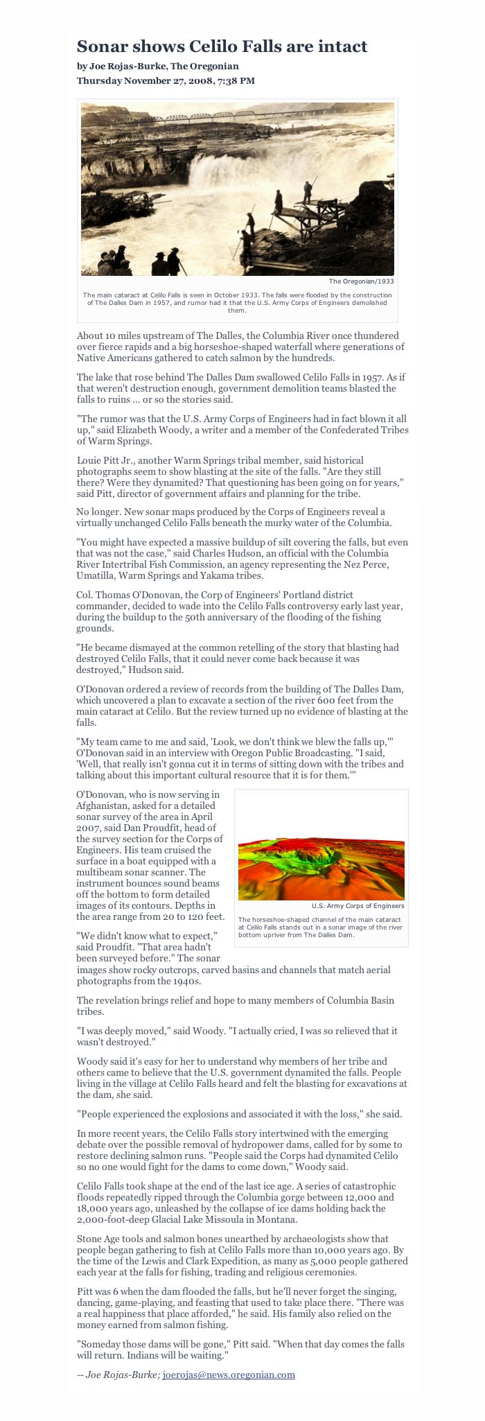
One of the first articles I wrote for the WyEast Blog continues to be among the most popular: Restoring Celilo Falls (February 14, 2009). In the spirit of keeping the idea alive, this article is a tribute to the way of life that all but vanished when Celilo Falls disappeared in 1957, as revealed in photographs.

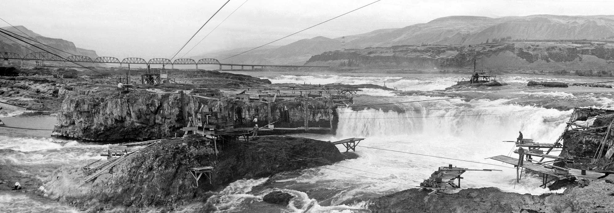
For this article, I blended images of Celilo Falls in the 1930s (courtesy the Oregon State University Commons archive) into a sweeping new panorama. I had viewed the individual images before, but it didn’t occur to me until recently that the following three images overlapped enough to allow for a blended panorama at relatively high resolution:

You can click here for a large view of the blended image, with the caveat that it retains the same publication terms as any other image in the Oregon State University Commons (use your browser window to pan across the image, as it is much larger than most monitors).

My original intent was simply to have a detailed panorama of the scene at Horseshoe Falls, the most iconic of the dozens of cataracts that made up the massive Celilo Falls complex. But as I stitched the images together, the details within the larger image suddenly came into view, and provided new insights into the unique way of life that had evolved over millennia at Celilo.

For example, in this clip (below) from the panorama, the surprising system for anchoring the wooden fishing platforms is revealed — a pile of rocks in a framed wooden crib! To my amazement, this method shows up in many other images of Celilo, though I had never noticed this detail before:

Another enlarged clip (below) from the panorama shows the precarious hanging platforms along a section of cliffs just below the falls, with fishermen using wooden ladders to reach what must have been slippery, intimidating perches:

In this enlargement from a separate photograph (below), taken just a few moments before the panorama images, the fisherman riding the cable shuttle to the opposite side of Horseshoe Falls is the same person visible in the panorama view (just below the fourth bridge arch):

The above view also shows a returning shuttle car, perhaps empty, or possibly loaded with filled salmon crates. Pulley systems like these moved fishermen and salmon catch on a network of cables that connected the multitude of rocky islands within the falls complex where fishing platforms were located.

In another clip (below) from the panorama, two fishermen are dipping from a group of platforms located at the extreme base of the falls. These platforms are also anchored with rocks, and are designed with dizzying overhangs that create a startling degree of exposure for the fishermen, yet provide a clear zone under the platforms for maneuvering dip nets:

The following clip (from a separate image) shows the same pair of fishermen seen in the previous clip from the panorama, but from a somewhat different angle. In this view, more details on how their platforms functioned are revealed: a crib of rocks anchors the middle platform, while and all three have large, wooden crates for salmon.

The size of the crates is also telling, as the typical salmon weighed 25-40 lbs, with many big Chinooks weighing in at well over 50 lbs. Landing these huge fish clearly required great skill, strength and agility using 15-foot dip net poles on a slippery plank surface.

Also visible in the above image are the safety ropes that the men tied to their waists while working the platforms. This was a relatively recent insurance policy in the ancient fishing tradition, and one that was seldom tested by people who had grown up around the platforms, working the salmon harvest.

The following image shows the top of the ladder seen on the right side of the panorama, but viewed from just above the platforms. As with the fishing platforms, the ladder is anchored by a wooden, rock-filled crib.

The above image also shows fisherman working on the next rock outcrop (in the upper left) seemingly afloat in the river, though clearly on another system of platforms in the larger panorama.

In another photo of the scene (below), the safety ropes can be seen in more detail — one tied to the fisherman — as well as the planked decking that was informally scabbed to platform supports.

Though sturdy, the informal construction of the platforms and catwalks makes sense, given that seasonal flooding almost certainly swept away anything that wasn’t removed by the fishermen at the conclusion of the fall fishing season. Yet, the position of individual platforms reflected traditional locations where the same families had fished over the generations. In that sense, while temporary in design, the platforms were also permanent.

The Tradition and the Legacy

Deconstructing these scenes in creating the panoramic view left me with an even greater appreciation for the fishing tradition at Celilo Falls. It also gave me new inspiration to see the falls restored, not simply for their scenic and spiritual value, but for the working fishery they provided. What a thrill it would be for the dip net fisheries to return to these rocks, and to watch them just as photographer who captured these images did!

The attraction of the Celilo restoration idea is that it is completely reachable. The falls is still there, underwater, and serving as a permanent reminder of our priorities as a society. It can be restored.

As the salmon runs continue to fade on the Columbia, along with the barge traffic once used to justify the dams, the sole argument against restoring Celilo Falls fades as well: it is as simple as finding better ways to generate — or conserve — the 1,800 megawatts of hydropower that is generated by The Dalles Dam. It’s really that simple.

Indian Salmon Harvest

1930s painting of Indians fishing at Celilo Falls, as they had for thousands of years prior to white settlement of the Oregon Country.

1930s painting of Indians fishing at Celilo Falls, as they had for thousands of years prior to white settlement of the Oregon Country.

In recent years, conservationists have lined up against a proposed Indian Casino in the Columbia Gorge, and with good reason. While the project would certainly benefit the people of the Warm Springs tribe, it would also have unacceptable environmental effects on the Gorge (A better solution is to simply locate the casino in Portland, which is the obvious force driving the Cascade Locks location – separate article to follow).

But if you are a like-minded conservationist, you have an alternative for supporting the Native American economy that doesn’t involve slot machines. Simply pack a large cooler on your next visit to the Gorge, and stop by one of several roadside salmon markets, where Indians from the Gorge tribes sell fresh, “over the bank” chinook, coho, steelhead, sockeye, walleye and shad.

1930s rendering of Indian fisherman working the narrows below Celilo Falls

1930s rendering of Indian fisherman working the narrows below Celilo Falls

A surprisingly small number of urbanites who visit the Gorge support these fishermen, possibly because they don’t understand the fishery. But if you have never had fresh salmon, you will be pleasantly surprised at the difference in flavor between the tribal fisheries and the fish-farm salmon that your local supermarket is likely selling as “fresh” (dyed pink to disguise its origin, since fish farms produce a gray meat in salmon).

The tribes also sell the finest smoked salmon available, anywhere — after all, they have had thousands of years to perfect the smoking process, and smoked salmon can be eaten plain, as a snack or with hors d’oeuvres, or used in salads, pasta, casseroles or other cooked dishes. Fresh and smoked salmon freezes well, so buying during the fall harvest, in particular, can provide for a full winter of salmon in your diet. This is an excellent option when fish isn’t available at the roadside markets, and helps the tribes sustain their economy over the winter months, as well.

The Nez Perce, Umatilla, Warm Springs and Yakama tribes have had permanent rights to harvest salmon from the Columbia River under a series of 1854-55 treaties with the United States Government. While these treaties have been subject to much litigation — and questionable “compensation” agreements allowed for destruction of Celilo Falls in the 1950s — the tribes manage the fisheries today in cooperation with the state governments of Oregon and Washington through the Columbia River Inter-tribal Fisheries Commission. The focus of the Fisheries Commission is on habitat recovery and sustainable fishing practices, and ensuring that this ancient tradition isn’t lost.

Indians fishing Celilo Falls with dip nets in the early 1900s, prior to construction of dams at Bonneville and The Dalles.

Indians fishing Celilo Falls with dip nets in the early 1900s, prior to construction of dams at Bonneville and The Dalles.

On a recent stop at the Cascade Locks market, beneath Bridge of the Gods, a young Indian in his teens asked me “if I knew any stories about Lewis & Clark”. I looked down at my faded t-shirt, commemorating the Lewis & Clark expedition, realizing why he had asked the question.

I responded with a few anecdotes from the expedition — how the Indians at Celilo had introduced the explorers to salmon, and in doing so, probably saved their lives. I also mentioned that the early white explorers unknowingly brought diseases with them that erased much of the native population, even before the huge waves of white settlers followed in the 1840s. To his apparent surprise, I also talked about the Corps of Discovery being the first true democracy in the United States, with an Indian woman (Sacajawea) and a black man (York) given equal voice at major turning points in the mission.

Upon that, he reached out, shook my hand, and said “thanks, man. I love to hear those stories.” But we both knew he was really testing my knowledge — and my respect for his native culture — to see if I was just another ignorant tourist in a Lewis & Clark t-shirt. I walked away with a bag of smoked salmon fillets and thinking what a complicated world it still is for young Native Americans.

You can learn more about the Indian Fishing Harvest at this official website, including the history of Indian fishing in the Columbia, where to find roadside stands, and how to buy fish from roadside vendors. Often, there are several vendors at a site, so if you plan to buy a few packages of fish, make your way from stand to stand, so that you support each of the vendors.

Restoring Celilo Falls

Celilo Falls has always been phantom of history to me, since I born a few years after the U.S. Army Corps of Engineers buried the falls behind The Dalles Dam in 1957. My understanding of the falls and the loss it now represents has come from old photos and maps, and a few shaky film images.

The railroad bridge in the background of this iconic view is the key to locating the falls today

The railroad bridge in the background of this iconic view is the key to locating the falls today

Yet for many, the falls and the native culture surrounding them are alive and vibrant in their memories, thanks to seeing and experiencing them first-hand. For Native Americans, the vivid memories only add to the pain of losing a place that quite literally defined a people for millennia.

The idea of restoring the falls — even temporarily — has been suggested over the years, usually to be slapped down quickly by the Corps of Engineers as unfeasible, or even dangerous. In the late 1980s, a brief, 30th anniversary movement to temporarily draw down the pool behind the dam briefly gained local momentum before the federal agencies killed any talk of the idea. The Corps likely realized that revealing the falls to the public even once could make it politically impossible to ever refill the dam again.

This 1940s aerial view shows the falls and railroad bridge, looking south

This 1940s aerial view shows the falls and railroad bridge, looking south

The hostility of the federal agencies toward even acknowledging the falls fanned the rumors among the local tribes that the falls had, in fact, been purposely destroyed by the Corps of Engineers just before they were inundated. This rumor persisted until last year, when a new mindset among Corps managers spurred the agency to compile a comprehensive sonar map of the falls to show that they are quite intact, beneath the still surface of the reservoir.

The sonar confirmation of the intact falls has breathed new life into the hopes of many that the falls will not just someday be restored, but perhaps someday soon. This is where the restoration of Celilo Falls fits within the scope of the MHNP Campaign: the emerging environmental theme in the coming century is restoration, and no place in the Pacific Northwest is more deserving — perhaps even the nation, considering that 11,000 years of Native American culture at Celilo makes it the oldest continuously settled place in North America.

This map clip correlates today's landmarks to the aerial view of the falls, above

This map clip correlates today's landmarks to the aerial view of the falls, above

But the connection to Mount Hood is even more elemental: the mountain towers over the Celilo country like a beacon, and has been a similarly important feature in the culture of Lower Columbia tribes. Celilo and WyEast are connected, and so their restoration should be. A joined effort to heal these places expands the possibilities for both.

What will a restored Celilo Falls look like? Initially, it will likely be mineral-stained and muddy. But the new sonar maps confirm that silts have not overtaken the falls, so if the pool behind The Dalles Dam were simply lowered today, we would see a largely intact falls — perhaps even with traces of the cantilevered dip net fishing structures that once clung to the rocks around the falls. And over time, the falls would quickly recover to blend again with the surrounding landscape.

R. Swain Gifford's 1875 etching of Mount Hood towering over the Celilo Narrows is among the earliest geographically accurate renderings of the area

R. Swain Gifford's 1875 etching of Mount Hood towering over the Celilo Narrows is among the earliest geographically accurate renderings of the area

What would a restored Celilo Falls mean for the mid-Columbia economy? The immediate impact would be on power supplies, and it is unlikely that the falls could ever be restored without some alternate energy supply — perhaps a wind farm of equal wattage? — ensuring that no net loss in energy production would result.

The next big question would be impacts on shipping, but the good news here is that barges were already using the Celilo Canal to bypass the falls long before the dam was erected. The canal system would conceivably resume this function, if the falls were reborn, albeit with likely improvements and modernization.

These scene was photographed in the mid-1950s, just before the falls was inundated

These scene was photographed in the mid-1950s, just before the falls was inundated

What kind of protection should the restored Celilo Falls receive? That part is easy. The astonishing scope of history tied to the falls easily qualify the site for World Heritage status within the U.S. National Park System, perhaps as a National Historic Site. This would put the restored falls in a category with places like Mesa Verde, in Colorado, and provide the needed framework to preserve and understand the historic resources that lie beneath today’s reservoir.

Restoration of Celilo Falls is a long-term dream of so many, but movement in that direction really began as soon as the falls disappeared in 1957. The falls has never left our collective consciousness, and thus demands restoration.

Another small step toward restoration will occur in 2009, when the commemorative Confluence Project will bring an art installation to Celilo. The project is marking the two centuries since Lewis and Clark passed through the region, and the millennia of human history that makes Celilo unique. A small step, but also a bit more progress toward what I believe will be the inevitable restoration of Celilo Falls — under the gaze of a restored Mount Hood.