The Rowena Oak
Somewhere under the heading of “hidden in plain sight” is a remarkable Oregon white oak (Quercus garryana) growing just a few yards from the Historic Columbia River Highway, near Rowena Crest. I stumbled across this old sentinel a few weeks ago while exploring the sprawling fields of arrowleaf balsamroot that Rowena is known for.
The venerable Rowena oak is not a particularly graceful tree: you won’t find it in coffee table books or on postcards. Though the gnarled trunks of these slow-growing trees are often living works of art, the Rowena oak is as much a battered monument to simple survival as it is a living sculpture. But it’s well worth a visit for anyone who loves ancient trees, and makes for a unique stop for those exploring the old highway.
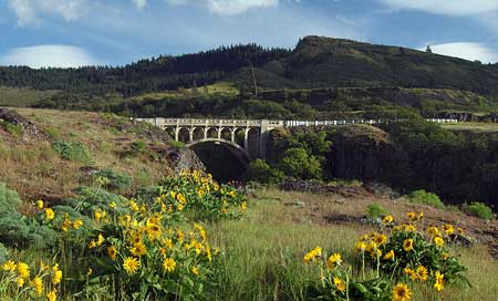
Dry Canyon Bridge and McCall Point from Rowena Plateau
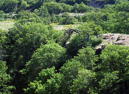
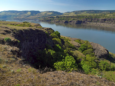
The tree is located in a most unlikely spot, near the brink of craggy Dry Canyon, a Missoula Flood feature that is part of the Rowena Dell canyon complex.
The sheer canyon walls are a reminder that the oaks surviving the harsh Rowena climate are anchored in a very thin layer of soil, atop hundreds of feet of layered basalt. This semi-desert ecosystem has an average of just 14 inches of rain per year, with hot, dry summers and freezing winters, and our infamous Gorge winds ready to strike up at any time, year-round.
The fact that Oregon white oaks can live to be hundreds of years old in this environment is truly remarkable. Part of their secret lies in a large taproot that not only anchors the trees in this windy, hostile environment, but also provides trees access to deep groundwater stored in the layers of basalt bedrock. The main taproot in these trees is complemented by a strong lateral root system, giving our native oaks an especially impressive root structure compared to most other tree species.
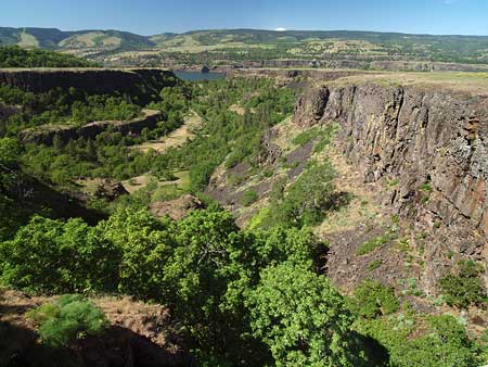
Dry Canyon and Rowena Dell from the highway bridge
Despite these challenges, the oak trees of the dry savannah found at Rowena are thriving, and even the ancient sentinels in these groves are blooming and producing acorns with each spring.
The Rowena Oak grows just a few yards from the historic Dry Canyon bridge, and was clearly here to witness the construction Samuel Lancaster’s Historic Columbia River Highway and Conde McCullough’s iconic highway bridge over the rocky gorge in 1921. The old tree probably stood witness to first railroads being built in the late 1800s, as well — and the rise and fall of the salmon canning industry that swept through the Gorge toward the end of the 1800s.
The Rowena Oak with the Dry Canyon Bridge in the background
In fact, at roughly two feet in diameter, the Rowena Oak could easily pre-date the arrival of Europeans in this part of North America. An Oregon State University (OSU) study of similar Oregon white oak habitat in Southern Oregon found that trees greater than 15″ in diameter were consistently 200 years or more years in age. The oldest oak in the OSU study was a whopping 429 years old, truly a testament to survival.
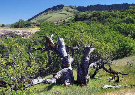
The huge, cascading Rowena Oak hangs into the protected niche of Dry Canyon
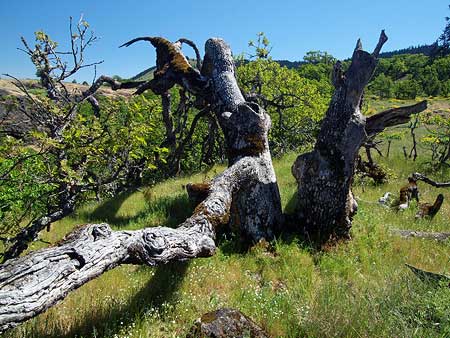
The arid climate at Rowena may be tough on trees, but it also helps preserve the life history of the old giants as they gradually succumb to the elements. Their broken tops and limbs are often preserved exactly where they fell decades ago, as mute testimony to the years of hardship these ancient trees have endured.
The Rowena oak is a great example, as it is surrounded by its own debris from decades of the ice storms, relentless winds and even the occasional lightning strike that are part of survival in the Gorge. The density of Oregon White oak wood helps in the preservation, as well — the same hardness that preserves its wood in the wild is also why these trees have historically been used to make furniture, flooring and barrels.
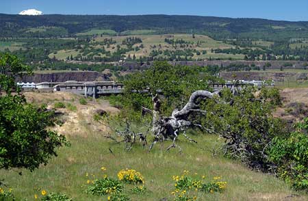
The Rowena Oak with Sevenmile Hill in the distance
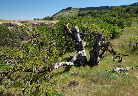
The Rowena oak has huge, twin trunks, the top of each toppled long ago by the elements. Lacking a top, the tree relies on four massive, sprawling limbs to survive, highlighting another survival secret of this species: Oregon White Oak sprouts prolifically from dormant buds on stumps and along trunks when tops are cut or broken off. This ability to adapt helped the Rowena oak survive what could have been catastrophic damage for most tree species.
The eastern of the two trunks points two massive, arching limbs toward the rim of Dry Canyon, and a closer look reveals yet another survival secret of this ancient tree: a tangle of branches cascade over the cliff like a leafy waterfall, with a lush canopy protected from the worst of the Gorge weather that sweeps across the top of the plateau.
A closer look at the sprawling Rowena Oak
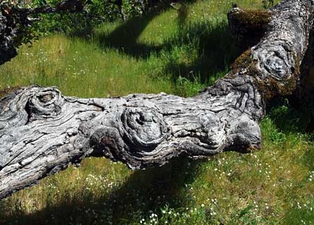
A third major limb, nearly a foot thick, snakes a surprising 50 feet from the eastern trunk, along the exposed cliff edge of the canyon. This huge limb hovers just 2-3 feet above the ground — yet doesn’t touch — thanks to the tremendous strength of its wood.
The huge, contorted limbs of the Rowena Oak have “eyes” that seem to be watching curious visitors!
The western of the two main trunks has just one surviving major limb, a crooked, cracked affair that touches ground at several points, surrounded by the bleached bones of its own branches, broken off over the decades. Each of the fracture points in this broken old limb is marked with a thicket of new sprouts, showing how this old tree continues to regenerate, extending its long life.
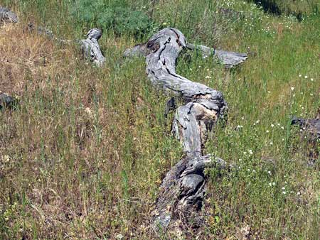
One of the many bleached “bones” that help tell the survival story of the Rowena Oak
While the Rowena Oak may look haggard, its growing limbs are healthy, putting out annual bursts of new leaves each spring, along with surprisingly abundant flower clusters. These will soon yield acorns, completing a reproductive cycle this tree has likely repeated since the time when Lewis and Clark passed by, if not longer.
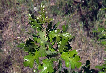
Spring brings another flush of new leaves on the venerable Rowena Oak
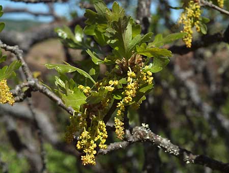
Spring blossoms on the Rowena Oak
Though most have been stripped by the elements or wildlife, several acorns from last year’s crop are still attached to the Rowena Oak, waiting to be dispersed. A mature Oregon white oak can produce anywhere from 20 to 50 lbs of acorns in a season, depending on growing conditions.
Acorns may look tough, but they are designed to sprout new tree seedlings as soon as moisture and warmth allow, as the seeds only remain viable for a year or so. Only a very few will sprout, and only a tiny fraction of seedlings will survive to become trees.
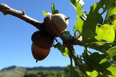
A few acorns from last season are still attached to the Rowena Oak
The thickets of younger Oregon white oak trees we see in some parts of the Gorge today may be the result of fire suppression over the past century. Studies of Oregon white oak groves in the Willamette Valley by Oregon State University suggest that pre-settlement fires regularly thinned out seedlings, allowing established oak trees to thrive without the competition of young oaks. Fire also kept other, competing tree species at bay that otherwise would have crowded out the native white oaks.
Visiting the Rowena Oak
Though the spectacular fields of yellow balsamroot and blue lupine have mostly faded, Rowena is always fascinating to explore. The Nature Conservancy owns and manages a sizeable conservation preserve covering much of the area.
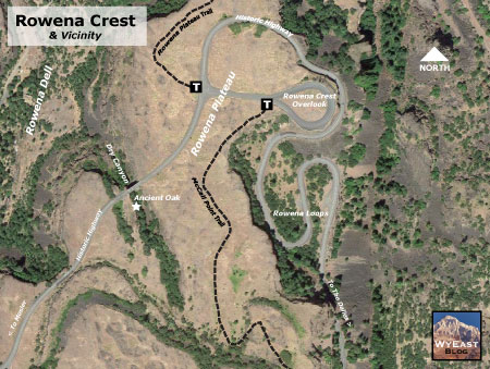
Visiting the Rowena Oak
(click here for a larger map in a new window)
A lower trail leads across the Rowena Plateau to a cliff-edge view of the Columbia River, and an upper trail climbs to McCall Point to a sweeping view of Mount Hood and the Gorge. Less adventurous hikers can still enjoy terrific views of the Gorge by simply hiking the first quarter mile or so of these trails, so there are hiking options for every ability.
The Rowena Oak is located just a few steps off the Historic Columbia River Highway, immediately west of the Dry Canyon Bridge. Roadside parking is available as you approach the bridge from Mosier. Simply walk uphill along the west edge of the canyon, and you will immediately spot the old oak from a low rise adjacent to the highway. This is an easy, rewarding stop for families with young kids, as the tree tells a fascinating story of survival.
Spectacular river views reward hikers on the Rowena Plateau trail
The longer hikes to the Rowena Plateau and McCall Point are quite busy during April and May during the wildflower bloom, but you’ll have them to yourself later in summer and fall, when the flowers are gone but the landscape is just as impressive. While the upper trail leads to broad views of the Columbia River and Mount Hood, the lower trail has a unique pair of “kolk” lakes formed during the Missoula Floods, and equally impressive views of the river and Rowena Dell.
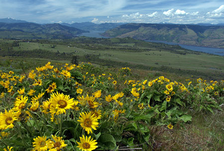
Springtime balsamroot atop McCall Point on the upper trail
As with all eastern Gorge hikes, use caution hiking in the heat of summer, as there is little tree canopy to shade these trails. The Nature Conservancy also asks that you stay on the trails, and be aware of the triple hazard of rattlesnakes, poison oak and ticks that are standard for the eastern Gorge. The first two in this list are easy to avoid, but you should prepare for ticks, and follow more rigorous precautions (see this recent article on ticks for a few tips). Note that the trails at Rowena are closed in the winter, when they can be slick and potentially hazardous.


![[click here for a larger map]](http://www.mounthoodnationalpark.org/MHNPArticles/110726BaldButteMapWide.jpg)
![[click here for a larger map]](http://www.mounthoodnationalpark.org/MHNPArticles/110726BaldButteTopoMap.jpg)
![[click here for a larger map]](http://www.mounthoodnationalpark.org/MHNPArticles/110726BaldButteMapClose.jpg)