Starvation Creek Loop Hike

Cabin Creek Falls

This blog has featured a series of articles on restoration of the former (and future!) Warren Falls, located in the Starvation Creek area. But there is a lot more to see in this interesting and less-traveled corner of the Columbia River Gorge, and this loop hike explores an amazing variety of scenery on a short, but demanding circuit.

Along this way, you’ll see four waterfalls, one “dormant” waterfall, ford two creeks, visit hanging meadows, peer over the brink of some truly breathtaking cliffs and enjoy expansive views of the Columbia River Gorge. You’ll want to print the large version of the trail map, below, as the trail network in the area is dense, and trail signage unreliable.

[click here for a larger, printable trail map]

The hike is best done from late April through early November, as the conditions can be somewhat treacherous in icy winter conditions, and the stream fords difficult in winter and early spring. But for adventurous hikers, this loop is generally open year-round, and provides a nice hiking option when snow covers the high country.

Hiker’s grim warning on a temporary sign at the Starvation Ridge Cutoff Trail..!

Note that the loop described here follows a specific direction, tackling the very steep Starvation Ridge Cutoff Trail first, in the uphill direction. This might seem counter-intuitive, but the steepness of this path is much harder on your knees going down than on your lungs and legs going up — and it can feel a bit slick and sketchy to descend, due to the steepness and exposure.

The Hike

The trail begins at the Starvation Creek Trailhead (directions at the end of this article). Head west from the parking area, walking parallel to the freeway exit, then drop into the trees following a section of the old Columbia River Highway. ODOT will soon be restoring this section of highway as part of a state recreation trail, so watch for construction to begin soon.

The welcome signpost marking the top of the Starvation Ridge Cutoff Trail

A short distance from the trailhead, you’ll see a signboard on the left marking the Starvation Ridge Cutoff Trail No. 414B (if you reach Cabin Creek Falls, you’ve gone too far). Take a deep breath, and begin the stiff climb up this trail, as it threads its way in a series of switchbacks through the towering cliffs that frame the Starvation Creek area.

Soon, the trail curves into the upper canyon of Cabin Creek, leaving the sounds of the freeway behind, and continuing steeply above the creek into dense forest until you reach the signpost marking the upper junction with the Starvation Ridge Trial No. 414.

The dizzying view of the trailhead from the top of the Cutoff Trail

The main loop heads to the right (west), and crosses Cabin Creek. But before you continue in that direction, make a brief detour to the left (east), following the Starvation Ridge Trail uphill for about 200 yards to a spectacular cliff-top viewpoint, a few feet off the trail. From here, you can peer a dizzying 500 vertical feet down to the trailhead and the tiny cars, trucks and freight trains moving below.

Looking west toward Shellrock Mountain and Wind Mountain from the Cabin Creek viewpoint

After resting your legs (and lungs) from the Starvation Cutoff trail, and enjoying the sweeping view from the overlook, retrace your steps back to the junction, and continue west on Trail 414, fording Cabin Creek. From here, the route climbs from the Cabin Creek canyon in a series of short, well-graded switchbacks, and passes another towering cliff-top viewpoint on the right.

The trail soon crests a divide marked by a 1930s-vintage transmission tower, and descends into Warren Creek canyon in a series of switchbacks traversing an enormous hanging meadow. In late April and May, the meadow features beautiful displays of shooting star and other wildflowers, but offers stunning views any time of year.

Shooting Star in the hanging meadow above Warren Creek

Great Hounds Tongue near Cabin Creek

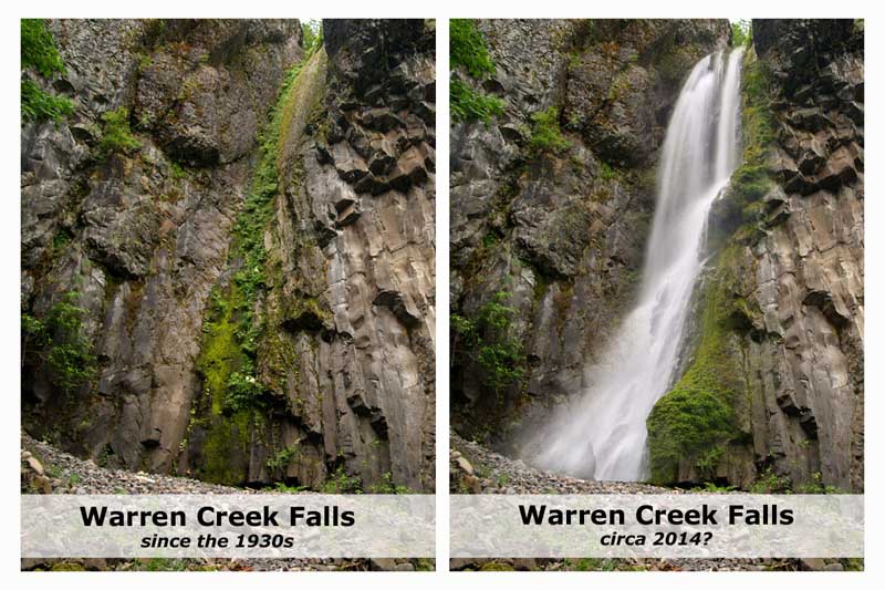
Soon, the trail re-enters forest, then reaches Warren Creek, a potentially difficult ford in winter and early spring. There’s no bridge here, so cross carefully. Warren Creek is the stream that once flowed over Warren Falls, just downstream from the ford. Since 1939 it has been diverted through an odd bypass tunnel that now forms manmade “Hole-in-the-Wall Falls”. You’ll pass both later on the hike.

From Warren Creek, the trail makes a gentle traverse along the forested canyon wall, then turns and crests another ridge below a second transmission tower, before descending across another open area with terrific views of the Columbia River Gorge.

The trail passes this mossy, cliff-top rock garden near Warren Creek

The view west from the Warren Creek viewpoint

The trail now descends to a 3-way junction of the Starvation Ridge (No. 414) and Mount Defiance (No. 413) trails, poorly marked with a very old signpost. From here, the loop hike continues to the right, turning steeply downhill. But first, go straight 200 yards to beautiful Lancaster Falls on Wonder Creek. This magnificent waterfall is named for Samuel Lancaster, the visionary engineer who designed the Historic Columbia River Highway.

Lower, trailside tier of Lancaster Falls

The best trailside view of Lancaster Falls is from the west bank, so be sure to rock-hop your way across. From there, you can also see part of the tall, lacy main tier of this beautiful waterfall (if you’re feeling really adventurous, it’s possible to scramble to a close-up view of the upper tier by heading uphill from the trail, just east of Wonder Creek).

After cooling off at Lancaster Falls, backtrack to the 3-way junction, and rejoin on the Starvation Ridge Trail No. 414, heading left as it descends steeply across an open slope, soon reaching a sturdy, new footbridge over Warren Creek.

Part of the magnificent main tier of Lancaster Trails, located off-trail

You’ll have views of man-made Hole-in-the-Wall Falls from the bridge, but waterfall lovers should take a few minutes to follow the obvious boot path that parallels the dry streambed to the left of the falls.

This streambed leads to the original, natural location of Warren Creek Falls — the topic of several articles on this blog. The hauntingly quiet amphitheater of the original falls is eerie, and it’s easy to imagine the sound and spectacle that once existed when Warren Creek poured over this cascade. During the periods of heavy winter runoff, Warren Creek occasionally overtops the diversion tunnel, and briefly flows down its natural falls. If you look closely, you’ll see evidence of winter storm events that have briefly brought the original falls and streambed back to life.

Warren Falls flowing in one of its rare winter appearances in March 2012

After taking in the scene at the former Warren Falls, retrace your steps on the boot path to the footbridge and turn right, continuing along the main trail for your return to the trailhead (note: the restored Historic Columbia River Highway and trail will soon be constructed in this area, with a new trailhead for the Starvation Ridge Trail relocated to this spot).

The route briefly passes an open area, and then re-enters forest. Watch for old, stone foundations covered in ivy in this area — you’re passing turn-of-the-century homesteads lost to time. Sharp-eyed hikers will also spot a pair of enormous anthills, each measuring six feet in height. A bit further, and you’ll also pass dome-shaped stone bake ovens, possibly built in the early 1900s by highway workers (see the map below for help in finding these traces of human history in the Warren Falls area).

[click here for a larger, printable map]

Finally, the trail rejoins the abandoned section of the old highway, following it to lovely Cabin Creek Falls. Photographers should take a moment to walk the short boot path to the base of the falls to capture the exceptionally beautiful scene. Crane your neck upward, and you will see the huge cliffs to the left of the falls that you skirted above on the Starvation Ridge Cutoff Trail!

To complete your journey, continue along the old highway grade back to the trailhead. A great way to end this hike is with a final stop at magnificent Starvation Creek Falls, the star attraction in this part of the Gorge. To reach the falls, head past the restrooms, and take the spur trail on the right. A string of streamside picnic tables make this an idyllic spot to relax after your hike, and enjoy a picnic lunch.

Misty base of Starvation Creek Falls

Hike Logistics

The usual Columbia River Gorge precautions apply on this hike: you’ll find poison oak, ticks and sheer cliffs, so it’s not a great choice for kids. If you’re bringing small kids on this hike, consider just hiking the lower portion to Lancaster Falls, where they will have plenty to enjoy without steep trails or dangerous exposure.

The steepness of the hike makes it a good candidate for cool weather, too. Hiking poles are especially helpful, and dogs should be leashed on this trail.

Getting there

The trailhead is at the Starvation Creek rest area, located at Exit 55 on I-84, about an hour east of Portland. The trailhead has water and restrooms, and no trailhead permit is required. The Starvation Creek exit is eastbound-only, so to return to Portland, you’ll need to drive another mile east to the Viento State Park exit, then follow the signs west to Portland.

For information on the Historic Columbia River Highway restoration project, check out the ODOT website, and click on “ongoing projects” for construction updates:

Historic Columbia River Highway Project

Visit Restore Warren Falls! on Facebook for more information on the project.

“Warren Falls, we’re ready for your close-up…”

On May 12, Oregon Public Broadcasting’s popular Oregon Field Guide program travelled to the site of Warren Falls to film a story on the unique history of Warren Creek: the odd 1939 highway department project that silenced the falls, and the potential for restoring the falls to its former grandeur.

Michael Bendixen and Vince Patton on the chilly January trip to Warren Falls

This was the second trip to Warren Falls for Oregon Field Guide producer Vince Patton and videographer Michael Bendixen. Both had joined me for a first look at the area on a particularly icy January day last winter when the Gorge was at its worst — freezing rain and sleet over a crusty layer of snow.

Our May 12 trip would prove to be the welcome opposite: unseasonably warm, summerlike conditions, with trails lined with ferns and wildflowers instead of snow. Along for the trip were PortlandHikers.org friends Adam Sawyer and Jamie Chabot, and Kristen Stallman and Andy Johnson, representing the ODOT team that is steering the Historic Columbia River Highway restoration project.

(from left) Adam, me, Andy, Jamie, Kristen, Vince and Michael at the trailhead

We met at the Starvation Creek trailhead at 9 AM, and loaded up our packs with OPB gear before making the short hike to Warren Falls. Along the way, the OPB team shot a few trail scenes, but were interested in getting to Warren Falls and Hole-in-the-Wall Falls while the morning light lasted.

Vince and Michael working at the mighty basalt wall formed by Warren Falls

We soon reached the massive amphitheater created by Warren Falls, where the OPB crew filmed the haunting scene of the silenced waterfall, marked only by the trail of moss that marks where the waterfall once flowed. The group spent some time here discussing the strange project that diverted Warren Creek in 1939, and the mechanics of the diversion tunnel and accompany flume that has long since disappeared.

Warren Creek had overflowed Warren Falls several times over the course of our wet winter, and there were obvious signs that a large amount of water had coursed down the old streambed. But on this day, the stream was dry, with the eerie quiet that now exists here.

Michael filming at Hole-in-the-Wall Falls

We backtracked to Hole-in-the-Wall Falls for another session of shooting. Here, the rest of the group visited while Michael and Vince captured several angles of the odd, accidental waterfall.

Adam, Andy, Jamie & Kristen at Hole-in-the-Wall Falls

For a good look at the bypass tunnel that creates Hole-in-the-Wall Falls, we moved to the knoll above the footbridge. From this spot, it’s easy to imagine the wood flume that once attached to the tunnel exit and carried Warren Creek over the old highway and railroad, all the way to the Columbia River. Only when the old flume disappeared was today’s man-made falls created.

Pointing out the man-made features of the upper portion of Hole-in-the-Wall Falls

A wood flume originally connected to the tunnel opening, carrying Warren Creek over the old highway and to the Columbia

Next, we hiked up the Starvation Ridge Trail, heading for the brink of Warren Falls, and the huge steel weir at the head of the diversion tunnel.

The original plan was to scramble down Warren Creek from the Starvation Ridge Trail ford for the quarter mile of bushwhacking required to reach the brink of the falls. But Kristen had been to the diversion structure a few days earlier with an ODOT engineering crew, and they had found a faint boot path that dropped more directly from the Starvation Ridge Trail.

We voted on the two options at the Starvation Creek ford: wet feet and a rock hop along the stream or pushing through a hillside of poison oak along the boot path? The poison oak option won the day!

Weighing the alternative routes at the upper Warren Creek crossing

We backtracked to the jump-off point for the boot path, descended through a manageable patch of poison oak, and soon found ourselves curving around a steep, grassy bluff hanging directly above the 120-foot cliffs of Warren Falls.

From here, a dramatic view of the massive Warren Creek diversion structure suddenly came into view, and the OPB crew set up to shoot the scene.

Rounding the approach to the brink of Warren Falls

Michael shoots the diversion structure from the cliff top above Warren Falls

The diversion structure is much larger up-close than the historic drawings or a glimpse from below the falls would suggest. The tilted weir is made from sixty 20-foot steel beams laid across a 28-foot wide trench carved into the cliff. Beneath the mesh of steel rails, the trench leads directly to the bypass tunnel.

A close-up view reveals at least half the weir to be filled with loose rubble, to the extent that it is lush with a strange hanging garden of wildflowers, A thicket of willow has even become established in the upper right corner of the weir, suspended 15 feet above the diversion tunnel, below. The forces of nature are taking back Warren Creek Falls, slowly but surely.

Vince takes in the huge steel weir that covers the diversion tunnel opening, rushing directly below him

The up-close view also shows most of the beams to be twisted and buckled with the ravages of time, thanks to rocks and debris getting lodged between the beams, and the effects of freeze-thaw cycles in the harsh Gorge winters.

Still, the overall structure represents an amazing ingenuity of design and construction detail to have lasted 73 years, but is still functioning as intended. While nature is clearly winning this battle, the persistence of the diversion project is silent tribute to the designers and builders who created these structures in 1939.

Jamie exploring the steel weir from below — the top of Warren Falls is few feet beyond

Jamie peers through the weir into the opening of the diversion tunnel, directly below

Vince found an opening in the upper corner of the weir, and set up a compact camera mounted on a short arm to film the scene below

The OBP team used a compact video camera mounted on an arm to shoot under the weir. Vince found an opening at the upper west corner of the weir that gave access to the view from below the steel beams.

From this angle, Vince was shooting just below the upper edge of the weir, where a 15-foot rubble and masonry dam was constructed across the creek to elevate the angle of the weir structure toward Warren Falls. For 73 years, this design has allowed for loose debris to roll off the weir and over the natural falls, while filtering the waters of Warren Creek through the weir into the bypass tunnel that now forms Hole-in-the-Wall Falls.

Vince filming the tunnel below the weir with the compact camera

Next, we moved to the top of the weir, crossing to the upper east corner of the structure. The view from the top of the weir looking over the brink of Warren Falls is impressive, as is the view toward the Columbia River. From here, Dog Mountain fills the horizon across the river.

But the fact that the river can clearly be seen from the brink makes a good case that Warren Falls was one of the “four cascades caused by small streams falling from the mountainsides” in Captain William Clark’s journal entry of October 29, 1805. The other three were presumably the nearby falls on Starvation Creek, Cabin Creek and Lancaster Falls on Wonder Creek.

Looking down Warren Falls from the top of the weir

Dog Mountain dominates the view from the top of the Warren Creek diversion dam

The view from the top of the weir shows more wear and tear on the structure: the mortared lip of the rubble dam is badly weathered, fully exposing the ends of many of the 60 steel beams that connect to it, with only a rusty bolt anchoring them to the masonry wall.

Here, the decay of the diversion system seems to be moving close to structural failure — another argument for an orderly removal of the weir, and restoration of Warren Falls before it becomes impossible to safely do so.

Close-up of the top of the weir shows the wear-and-tear of 70 years

Vince and Michael planning the shoot from the top of the Warren Falls diversion dam

Jamie helps Michael set up at the top of the diversion structure

The group settled in for a lengthy shoot at the top of the falls, where Michael and Vince worked to capture the setting, and the rest of the group enjoyed the sylvan scene along Warren Creek.

Michael shooting from midstream, at the brink…

Michael posing for a certain Oregon Field Guide fan!

It’s a long drop: Michael shooting from the top of the diversion

The OPB crew wrapped up the day’s shooting with a few interviews and reflections of the group on the diversion project, and the future of Warren Falls. We soon packed up the video gear, and started up the canyon slope for the trail.

Adam shooting the OPB crew… shooting Warren Falls…

On the trip back to the trailhead, we ran into several groups of curious hikers, all familiar with Oregon Field Guide and excited to meet the crew.

One young woman asked what we were filming, and I explained the story to her — and asked her to go to Restore Warren Falls! on Facebook. Later, she approached me at the trailhead, and asked “Why are you focusing on this when there are so many global issues facing the world?”

Jamie muggles the geocache at Warren Falls. We signed it “Oregon Field Guide”

At the time I was somewhat startled, and replied that the project to restore the Historic Columbia River Highway provided a unique opportunity for funding the restoration of Warren Falls — a good argument, and one she seemed to accept. But I wish I’d simply said “We have to start somewhere, and right now, this is as good a place as any!”

“I wondered why somebody didn’t do something. Then I realized, I am somebody.”

~Author Unknown

(Special thanks to the Vince, Michael, Jamie, Adam, Andy and especially Kristen for another great day imagining the past and future Warren Falls)

___________________________

Previous articles on restoring Warren Falls:

Restoring Warren Falls
Warren Falls Lives! (temporarily, at least)
Warren Falls Mystery… Solved!
Warren Falls Solutions
Warren Falls Lives… Again?

Restore Warren Falls! on Facebook

Warren Falls Lives… Again?

March 16 was a good day for Warren Falls: in the morning, the Historic Columbia River Highway Advisory Committee (AC) allowed me time on their agenda for a second pitch to restore Warren Falls as part of the larger historic highway trail project. After the meeting, I visited Warren Falls and was able to capture it flowing, thanks to the unusually heavy rain we had experienced in early March. Here are the highlights:

HCRC Advisory Committee

Last summer, I made a pitch to the HCRC Advisory Committee (AC) to restore Warren Falls as part of the highway restoration project, and in my second appearance, was able to provide a much more polished case. The members of the AC were engaged and clearly interested in the idea, asking many questions after the presentation. However, they are also constrained by the tight budget and timeline they are working under to complete the highway restoration by the 2016 centennial of Samuel Lancaster’s “King of Roads.”

The HCRH trail design already includes a short trail and overlook at Warren Falls

The AC chair sent me a follow-up message after the meeting offering support for all of the proposals I had laid out at the meeting — except restoration of Warren Falls itself. While that last part was disappointing, it was helpful to at least have a sense of where the AC stood on the issue, since I can now focus efforts on finding the needed funding and perhaps a project partner for ODOT to pull off the Warren Falls restoration.

The good news is the AC is supportive of several accompanying proposals that I laid out in the presentation, including:

• designing the crossing of the original Warren Creek channel to resemble a “bridge” so that there will be a place for an interpretive panel describing the history of the area

• addition of a side trail to the original Warren Falls with an interpretive panel – albeit, with “volunteer work”

• Enhancing fish habitat downstream of Hole-in-the-Wall Falls as a proposed mitigation action related to construction of the next (unfunded) trail segment west of the Starvation-Lindsey segment currently being designed

• removal of invasive species in the area – mostly, English ivy, Himalayan blackberry and Scots broom.

So, despite the disappointment of not adding the falls restoration to the current ODOT project, the list of related restoration work supported by the AC is a big step forward. In their words, the AC is “supportive of [the] idea to bring water back to the original waterfall, but given our charge, we cannot offer any monetary or construction assistance”. A partial victory, to be sure, but also a challenge to help ODOT find funding for the Warren Falls restoration.

This historic streambed of Warren Creek, now permanently cut off from the stream, could have a “bridge-like” crossing and an interpretive sign describing the area history.

An interesting footnote to the meeting was a conversation I had afterward with a reader of this blog who had watched the presentation, and thought a much simpler solution was possible for restoring Warren Falls: simply pull out the “trash rack” grate, and let Warren Creek do the rest. The stream would surely plug the tunnel with debris and gradually start flowing over its original falls without an elaborate engineering solution for retiring the tunnel.

It’s a temptingly simple idea, and came from a person with a professional background as a hydrologist, no less. So, that scaled-back option will be my starting point as I look for additional funding for bringing back Warren Falls.

Warren Falls Lives!

After the HCRH Advisory Committee presentation, I bolted for the Starvation Creek trailhead, with a strong hunch that Warren Falls would be flowing that day. Despite the bright, blue skies on March 16, the previous week had seen an unusually cold and wet weather pattern, and the gorge waterfalls visible from the highway were roaring.

As hoped, when I arrived at Hole-in-the-Wall Falls, part of Warren Creek was flowing down the normally dry channel that leads to Warren Falls. I captured the following video as I walked along the temporary stream, then rounded a corner to find water flowing over Warren Falls, once again. Warren Falls lives!

As with previous visits when Warren Falls was flowing, the experience was magical. Instead of hearing the echoes of trucks on I-84 in the dry amphitheater surrounding the falls, I could hear only the sound of Warren Creek — or the overflowing part of it, at least — cascading over the 120-foot brink of the falls, then splashing down the normally dry streambed to the point where it re-joins the main stream of Warren Creek, at Hole-in-the-Wall Falls.

This clip marks the moment when a large rock came over the falls, in the background… CRACK!

The video still image, above, marks a somewhat jarring moment on this visit, however: if you listen closely at 0:47 you can hear a CRACK! in the background, then an abrupt end to that clip in the video. This is the sound of a soccer ball-sized rock coming over the top of the falls — just as designed — and landing in the debris pile near the base. It was not only startling to hear this, but also a bit ominous, considering that on previous visits I had been standing at the base of the falls shooting video and still photos. If you visit when Warren Falls is flowing, please don’t stand near the base of the falls!

Finally, there was a pleasant surprise on the way out that day. For some reason I had never noticed, but the USFS trailhead sign at Starvation Creek (pictured at the top of this article) actually lists Warren Falls as a destination! Clearly, the Forest Service meant Hole-in-the-Wall Falls, but I choose to look upon the sign as a good omen that the real Warren Falls will be restored!

Friends for Warren Falls

My month of Warren Falls adventures continued on March 25, when I guided a Friends of the Gorge hike on a tour of the Starvation-area waterfalls, including a visit to Warren Falls. At 24 hikers, the group was by far the largest I have led to the falls site!

Friends of the Gorge hike visits the site of Warren Falls

Warren Falls was once again dry on this visit, but the group was fascinated by the odd history of the diversion project, the obvious signs that Warren Falls had recently flowed, and the magnificence of the massive basalt amphitheater that frames the falls.

Restore Warren Falls on Facebook

I’ve had many people ask how they can support the effort to restore Warren Falls. In response, I have finally set up a Facebook page for people to track progress on the project and vote their support for the idea:

Warren Falls on Facebook

You can help out by stopping by the Facebook page, like it, and then forward the web link to like-minded friends. If the project picks up enough “likes”, it will help me make the case to ODOT and elected officials that popular support exists for the project.


Thanks go out to those who have already stopped by the Facebook page, and thanks, especially, to Scott Cook for speaking out in support of Warren Falls at both HCRH Advisory Committee meetings — very much appreciated, Scott!

Please watch the Warren Falls page on Facebook for more updates on the project as the it unfolds over the next several months.

Warren Falls Solutions

The strange history of Warren Falls began shortly after completion of the Historic Columbia River Highway in the 1920s, when unruly Warren Creek repeatedly pushed debris against the modest new highway bridge that spanned the stream.

The first Warren Creek bridge was replaced as part of the waterfall diversion; no photos of the original structure survive

Oregon highway engineers subsequently diverted the creek in 1939 through a bizarre tunnel that survives to this day. The diversion created today’s manmade Hole-in-the-Wall Falls when an accompanying flume was removed sometime in the early 1960s, leaving an eerie, dry cliff where Warren Falls once thundered.

This article proposes a few solutions for restoring Warren Falls to its former glory in tandem with the ongoing ODOT project to restore the Historic Columbia River Highway.

Option A: Let Nature Take Her Course

The simplest solution for restoring Warren Falls is to simply wait for the “trash rack” diversion structure to rust away, eventually collapsing into the tunnel intake under the weight of a heavy winter flood or debris flow. Surprisingly, this hasn’t already happened over the 73-year life of the diversion project, but it is inevitable.

Debris flows periodically clog the brink of Oneonta Falls; a similar event is inevitable at Warren Falls

This is the least desirable option because it leaves the maintenance and safety liability of the diversion tunnel in ODOT’s hands, and the removal of obsolete structures to chance. The dry falls and diversion tunnel are visited regularly by curious hikers, canyoneers and rock climbers, so the unresolved safety liability the tunnel presents for ODOT is quite real.

Option B: A Large Cork

Short of waiting for the “trash rack” diversion structure to collapse on its own, the simplest option for restoring Warren Falls is to cork the tunnel intake. A vault carved like a rocky bathtub into the bedrock brink of the falls forms the tunnel intake, and provides for the “cork” solution.

Though the metal “trash rack” covers an opening of roughly 20×20 feet square, the rock vault is tapered in a v-shape, narrowing to the 5 foot width of the tunnel at the bottom of the vault. The “cork” would be a series of stacked basalt columns filling the vault and blocking the bypass tunnel opening. Approximately twenty 6-foot columns, each about 18 inches in diameter would do the job.

The 1939 construction drawings for the diversion project show the v-shaped vault carved into the lip of Warren Falls, leading to the diversion tunnel (cross-section view)

Mother Nature would provide the assist for this solution once the basalt columns are in place, with the hydraulic force of Warren Creek filling the spaces between columns with fine gravels and sediment over time. Eventually, the voids between the columns would fill completely, plugging the bypass tunnel to all but a small amount of seepage.

The lower end of the corked bypass tunnel would also be covered with a protective grate to prevent curious explorers from entering, just as a number of lava tubes in Oregon have been gated to public access. The bonus? A very large, secured bat cave is created in the process!

A stack of basalt columns like these would form the “cork” that plugs the bypass tunnel forever (Wikipedia)

How would the basalt columns get up there? The best plan would be an air crane, as the rock columns would be comparable in size and weight to the timber loads that are routinely lifted in Oregon’s helicopter logging operations.

ODOT maintains an open maintenance field just a few hundred yards from the falls site, with direct freeway access for delivering the columns to a staging area. On-the-ground workers could access the top of the falls from the Starvation Ridge Trail, but a mechanical lift from the base of the falls would be more practical.

Option C: Colossal Dental Work

The third option is the best plan for fully restoring Warren Falls to near-natural conditions. This design would “fill the cavity” of the entire bypass tunnel, permanently.

Construction detail of the lip of the masonry dam that supports the “trash rack” (cross-section view)

This solution uses the original masonry dam at the head of the bypass tunnel to temporarily pipe Warren Creek over the natural falls during the construction phase, allowing for concrete work to proceed within the bypass tunnel.

The tunnel would be plugged in two steps. First, a reinforced concrete plug would be poured at the lower opening of the bypass tunnel, sealing the tunnel exit. The plug would be disguised on the outside to match the color and texture of the basalt cliff.

Next, the rest of the tunnel would be filled with mixture of concrete and rock cobbles — roughly 100 cubic yards worth. Once the tunnel “cavity” is filled, the vault at the top of the falls would be filled with basalt columns, using the same method described in the “cork” scenario. In this case, they could be mortared in place, since this approach would already have concrete pouring equipment on site.

Wanted: dentist with masonry skills and a helicopter pilot license… (photo: Zach Forsyth)

The “dental work” option has the benefit of stabilizing basalt cliffs that form the western wall of Warren Falls by permanently filling the man-made cavity behind them. This option allows ODOT to walk away from the Warren Tunnel site forever, with almost no trace of the old stream diversion left behind.

How would ODOT move the concrete and rock to the top of the falls? Fortunately, much has changed since the tunnel was originally created, and today there is portable equipment specifically designed for the task.

First up is a truck-mounted concrete pump, normally used for precision pouring in building construction, but increasingly used to minimize environmental impacts at construction sites.

This truck-mounted concrete pump would easily reach the top of Warren Falls (Wikipedia)

Moving rock to the top of the falls would be a bit more cumbersome, but could employ a portable rock conveyor. These are widely used in commercial aggregate operations, and could conceivably be used at the Warren Falls site. A low-budget alternative is to us rock from Warren Creek’s streambed above the falls.

Moving heavy equipment to the site would drive up the cost of restoring Warren Falls, so the “dental work” option for completely decommissioning the old tunnel is probably the least viable alternative, given funding constraints. But it’s also possible that ODOT will already have equipment required to do the job in the area as part of the project to restore the historic highway.

A telescoping rock conveyor could be the solution for loading aggregate into the Warren Tunnel (Wikipedia)

Next Steps?

Why link restoration of Warren Falls to the Historic Columbia River Highway project? The answer lies in the intertwined history of the falls and the highway department: now is the time for ODOT to undo an unfortunate environmental travesty from another era.

The historic Columbia River Highway restoration project provides a once-in-a-lifetime opportunity to provide the resources needed to restore the falls. It also allows ODOT to demonstrate how much highway planning has evolved since the diversion project was conceived, more than 70 years ago.

I will be making another pitch to restore Warren Falls at the Historic Columbia River Highway advisory committee meeting on March 16 (in Hood River). Hopefully, I’ll be able to capture the imagination of the citizens and ODOT staff charged with returning the old highway to its former glory, and make the case that restoring Warren Falls ought to be part of the larger restoration effort.

More to come…

Warren Falls Lives! (temporarily, at least)

Warren Falls flowed briefly in early December

As an update to this recent article on restoring Warren Falls, I made a trip to the site of the former falls during a classic “pineapple express” pattern of winter monsoons earlier this month. I was thrilled to find a small amount of Warren Creek cresting the weir that has diverted the creek into a bypass tunnel for the past 75 years, and pouring over the falls.

It was remarkable to be in the amphitheater with water cascading over the escarpment, once again, and even if only temporarily. The small amount making its way over the brink completely changed the place from an eerie, somber cavern to a bright, sparkling glen. It was even more exciting to imagine the full force of Warren Creek plunging over the high cliffs, given the thundering display at Hole-in-the-Wall Falls (which is created by the bypass tunnel).

Here is a short video from that day that captures the scene and tells the story of Warren Falls:

Restoring Warren Creek Falls

Early 1900s map of Warren Creek, before the falls was diverted

Until the 1930s, Warren Creek was much like it’s neighbors to the east and west in the Columbia River Gorge, plunging in a spectacular waterfall as it reached the final wall of cliffs lining the river. For millennia, the stream had slowly carved a huge amphitheater in sheer basalt, thundering into a deep splash pool at the base of the cliffs, before rushing to the Columbia.

The railroads crossed Warren Creek in the late 1800s, and by the 1920s, Samuel Lancaster’s iconic Historic Columbia River Highway had been constructed, and passed the stream near the falls. Sometime in the late 1930s, the Oregon Highway Department determined that Warren Creek posed a risk to the highway grade, and made the improbable decision to re-route the falls through a tunnel, depositing the stream a few hundred yards to the west.

Man-made Hole-in-the-Wall Falls flows from a tunnel

The legacy of this bizarre project is man-made waterfall now known as Hole-in-the-Wall Falls, for the fact that Warren Creek continues to burst out of the diversion tunnel blasted in the 1930s. The true falls are still “upstream”, so to speak — the streambed of Warren Creek above the man-made diversion is now dry, though it looks to have flowed yesterday.

At the head of the dry streambed, the former Warren Creek Falls also looks as if it flowed recently, even though the diversion has been in place for more than 70 years. A bright green ribbon of moss and ferns traces the graceful chute where a horsetail-shaped falls once roared down the cliffs. A huge mound of debris has since accumulated at the base of the falls, perhaps from occasional overflows of the weir above the falls that normally directs the stream flow to the diversion tunnel.

The dramatic basalt amphitheater of Warren Creek Falls

Someday, a natural storm or geologic event will surely block the tunnel, or destroy the weir, and Warren Creek Falls will once again flow through its magnificent grotto. But why wait? What better statement of our dedication to healing the misguided scars of the human past than to bring back this lovely waterfall?

The benefits would be many. First, the natural setting of the falls is unique and spectacular, and would become an instant destination for hikers and waterfall lovers. Though there are hundreds of waterfalls pouring over basalt cliffs in the Gorge, the basalt columns at Warren Creek Falls are especially dramatic. Restoring the falls would also add back several hundred yards of salmon and steelhead habitat, since Warren Creek flows directly from the falls site to the Columbia.

Approaching Warren Creek Falls from the dry streambed

The project could also serve a preventive purpose, since the long-term impact of introducing water to the bypass tunnel may be undermining the stability of the huge cliff face that it passes behind. Already, there are signs of spalling rock on the cliffs near the tunnel, suggesting that the diversion is having an impact on the structural integrity of the cliff. Decommissioning the tunnel could at least arrest this impact.

A section of the long-dry streambed that looks to have flowed yesterday

As fanciful as this project seems to be in a time of tight public budgets, there happens to be a once-in-a-generation opportunity to link the restoration project to a nearby transportation improvement. According to tentative plans for the Historic Columbia River Highway (HCRC) project, the segment of old highway that passes in front of the falls will soon be restored and reopened as a bikeway and pedestrian path, similar to other sections that have been restored over the past two decades.

There is perfect symmetry to linking the waterfall restoration to the reopening of the highway, since it was the highway that led to the demise of the falls. This symbolism is important as a statement of healing and environmental justice. Therefore the project planning should include not only the planners, scientists, architects and engineers needed to design the effort, but also Native Americans representing the countless generations of native peoples who likely visited this spot over the millennia, and perhaps considered it to be of spiritual significance.

The HCRH plan is the key for restoring Warren Creek Falls

How would this work?

How would restoration of Warren Creek Falls work? The first task would be to prepare the dry stream bed for the return of an energetic, flowing stream. Warren Creek is fed year-round by snowmelt from the high slopes of Mount Defiance, and the dry streambed provides a perfect opportunity to engineer an ideal salmon and steelhead habit.

Next, the crowded thicket of young Douglas fir that has colonized the spray slope of the splash pool, near the falls, would need to be thinned and prepared to grow into a healthy stand, perhaps someday framing the falls.

There is also a fair amount of English ivy in the area (dating back to the roadhouses and homesteads that once dotted the old highway) that must be pulled, and this would make for an ideal volunteer project. Likewise, groups like Trailkeepers of Oregon could design and build the short footpath needed to take visitors from the old highway to the base of the newly restored falls.

Finally, the stream diversion at the top of the falls would need to be dismantled. Blocking the diversion tunnel is straightforward – the tunnel is only about five feet in diameter, and could be filled with natural stone or a manufactured plug. The weir at the top would also be removed, allowing the stream to flow into its natural course, and over the falls.

Upon completion of the project, Warren Creek Falls might look something like this:

(click here for a larger view)

What would become of the man-made Hole-in-the-Wall Falls? It would be reduced to a mossy spot on the cliffs, much like Warren Creek Falls is today. But interpretive signage along the adjacent trails could simply point to this curiosity as a symbol of humanity’s hubris, and an earlier time when engineers moved inconvenient waterfalls simply because they could.

This should be an easy project to accomplish, but unlike those bold days of the 1930s, when an engineer could simply decide to move a waterfall, modern times call for more planning and preparation. The HCRH project provides the perfect venue for accomplishing the planning and for funding the project.

However, it will require ODOT to be creative, and involve other state and federal agencies that can help with the project details. But with some ingenuity and dedication, it is quite possible that the falls could be flowing again by 2014, the centennial celebration of Samuel Lancaster’s spectacular road. It’s hard to imagine a better tribute to Lancaster’s original vision than to restore a falls that he specifically had in mind when he designed this section of his elegant highway.

Visiting the falls

It’s fun and interesting to visit the dry Warren Creek Falls. Simply follow I—84 to the Starvation Creek State Park exit, park at the rest area, then follow the trail signs pointing west to the Starvation Ridge Trail. The route briefly follows noisy I-84, then ducks into the trees, following the moss-covered surface of the old highway past Cabin Creek Falls, a tall, wispy cascade framed by house-sized boulders.

A short distance beyond Cabin Creek, the route becomes a forest trail, soon arriving at the bridge over Warren Creek at the half-mile mark, at the base of Hole-in-the-Wall Falls. Look to the left before crossing the bridge, and you will see the dry former stream bed of Warren Creek coming around a bend. Simply follow the old stream bed for 200 yards to the massive, hauntingly quiet amphitheater of the former falls. Look closely, and you’ll see markings on the cliff that date back to the construction work on the bypass tunnel that passes behind this cliff.

Cliff markings at Warren Creek Falls dating to the construction of the diversion tunnel

You can extend your hike another half mile to Lancaster Falls by continuing over the bridge, then uphill to a T-junction: go right for a short distance to reach the bottom tier of this very tall falls, named for Thomas Lancaster. For still more hiking, you can retrace your steps to the T-junction, then continue about one-half mile east and uphill on the Starvation Ridge Trail to Warren Creek. You’ll pass scenic cliffs and viewpoints along the way, and the bridge-less trail crossing at Warren Creek makes for a pleasant lunch spot.