2019 Campaign Calendar!

00CoverWhaleCreek

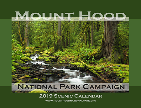
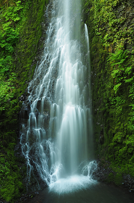
Calendar cover for 2019 featuring Whale Creek

[Click here for a large image]

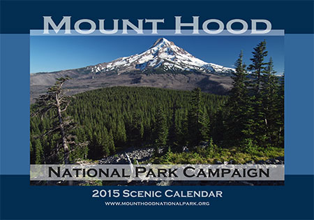
‘Tis the season for top ten lists and year-end retrospectives, so in that spirit my annual Mount Hood National Park Campaign Calendar is pretty good snapshot of 12 favorite spots of mine across WyEast country this year. Since 2004, I’ve created an annual calendar dedicated to the campaign, each with a fresh set of photos. If you’d like a 2019 calendar, there’s info at the bottom of the article and ALL proceeds will once again go to Trailkeepers of Oregon (TKO).

________________

The annual campaign calendar has been a great motivator for exploring new terrain and improving my photography skills over the years. Each year the calendar project also renews my conviction that Mount Hood and the Gorge are uniquely special places, and deserve better care.

This article is a short tour of the 12 spots that made it into the 2019 calendar, with a few stories behind the photos and reflection on these increasingly fragile landscapes.

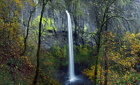
Starting with the cover image (at the top of the article), the calendar begins at lovely Whale Creek, a tributary of the Clackamas River that is also featured in the March image, so more about that spot in a moment.

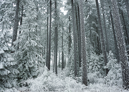
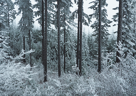
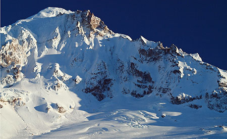
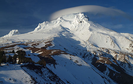
Next up, the January image (below) captures the awesome west face of Mount Hood, where the Sandy Headwall towers 3,000 feet above the Sandy Glacier. This snowy view was captured from near Lolo Pass last winter.

01aLoloPassEastHood

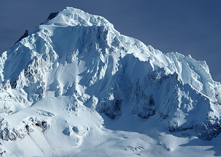
January features the awesome Sandy Headwall

[Click here for a large image]

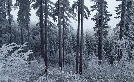
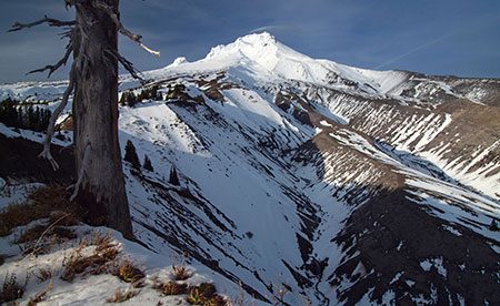
Not included in the close-up view are the bare slopes of Barrett Spur (below) and other alpine ramparts of Mount Hood that still didn’t have their winter snowpack in early February, when these photos were taken. While it’s not uncommon to have a late snowpack in the Cascades, these events are becoming more common as global warming unfolds in our own backyard.

01bLoloPassEastBarrettSpur

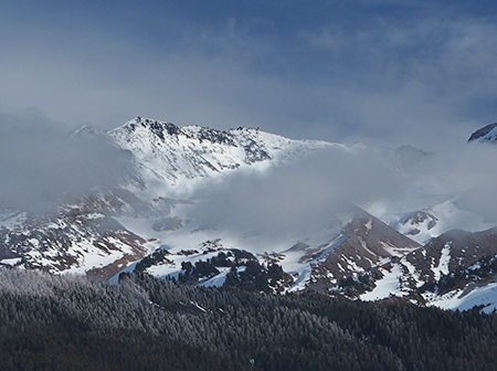
Low snow on Barrett Spur in February tells the story of our changing climate

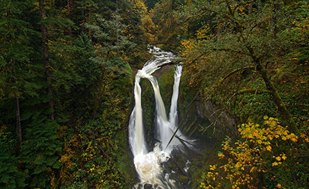
For February, I chose a close-up perspective of the ice “pillows” that form at the base of Tamanawas Falls (below) in winter. This has become a very popular winter destination in recent years, thanks in large part to social media! (…ahem…)

02aTamanawasFallsDetail

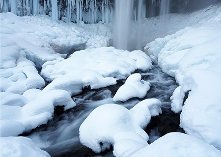
February features Tamanawas Falls

[Click here for a large image]

Tamanawas is Chinook jargon for “guiding spirit”, and is one version among a couple variations in spelling. More challenging is the pronunciation, and with the advent of social media, all manner of spoken variations are being used. For some reason, an especially popular spoken version that doesn’t even correlate to the actual spelling is “tah-ma-WAHN-us”.

It turns out the most accepted pronunciation is “ta-MAH-na-wahs”. I’ve been saying a slight variation of “ta-MAN-a-wahs” for most of my life, so I’ll need to work on that!

02bTamanawasFalls

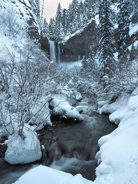
Cold Spring Creek and Tamanawas Falls in winter

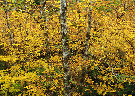
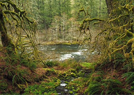
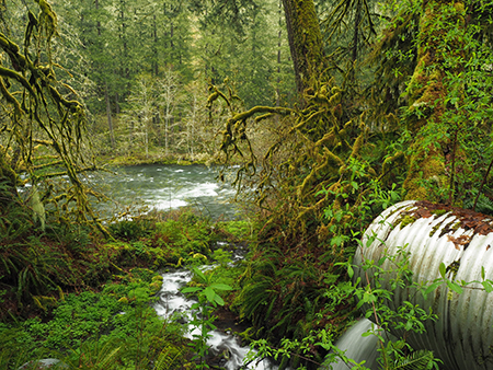
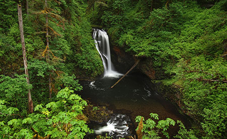
As mentioned earlier, the March calendar image is from Whale Creek (below), located in the heart of the Clackamas River canyon. The creek is hidden in plain sight, flowing through the Indian Henry Campground and next to the east trailhead of the Clackamas River Trail. This area features some of the finest rainforest in WyEast country.

03aWhaleCreekBigCedars

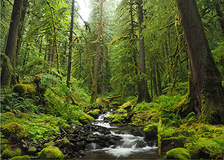
March features a rainforest scene along Whale Creek

[Click here for a large image]

Whale Creek was just one of many places in the Clackamas and Molalla River watersheds that I found myself exploring this year while much of the Oregon portion of the Columbia River Gorge was closed by the Eagle Creek fire. I visited the lower reaches of Whale Creek after seeing stunning photos of a string of waterfalls on the upper reaches of the creek, and quickly fell in love with this pretty stream. Watch for a future article on a trail concept I’ve been working on for Whale Creek with TKO and some area waterfall explorers.

03bWhaleCreekScene

Whale Creek in the Clackamas River canyon

Sadly, the Clackamas River corridor has a bad reputation, thanks to a history of lawless behavior (the recent Pit Fire was started by illegal target shooting, for example) and a long history of Forest Service management that viewed the area more like a tree farm than a forest — and the two go hand in hand, by the way.

Yet, hidden in the now-recovering rainforests of the Clackamas are dozens of spectacular waterfalls, towering basalt walls and rugged vistas that rival the Columbia River Gorge in beauty. There are also a lot of big trees that somehow dodged the logging heyday of past decades.

03cWhaleCreekSnow

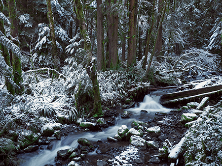
Whale Creek in winter

The Clackamas River corridor holds great promise for future recreation alternative to places like the Gorge, and the proven cure for lawless behavior is lawful recreation. I’m optimistic that we’ll make that transition here, and begin valuing places like Whale Creek for the intrinsic value of its forests, not just the saw logs it can produce.

04aWhiteRiverFalls

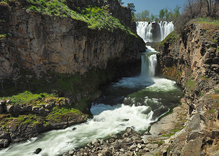
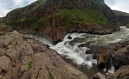
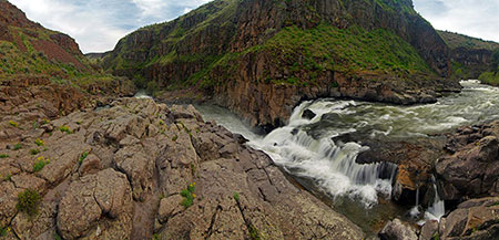
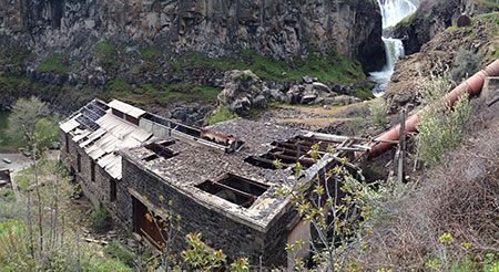
April features White River Falls State Park

[Click here for a large image]

For the April calendar image, I selected a photo of White River Falls, both for the contrast in WyEast country ecosystems it displays and because this little state park could use some love and expanded boundaries. I posted an article with just such a proposal a few years ago, you can find it over here.

04bWhiteRiverUpperFalls

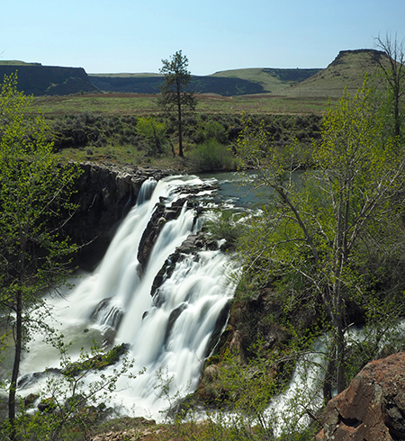
White River Falls with unprotected desert country beyond

The May calendar image features a sweeping view of the Upper Hood River Valley (below) from little known, seldom-noticed Middle Mountain. Its name tells the story, as forested Middle Mountain divides the upper and lower portions of the Hood River Valley. I learned of this spot about ten years ago from a local photographer and have gone back pretty much every year since.

05aMiddleMountainHood

May features the Upper Hood River Valley as viewed from Middle Mountain

[Click here for a large image]

Zooming in a bit to this idyllic landscape reveals a seemingly timeless farm scene that is easy to take for granted. And yet, these farms were at great peril just a few years ago, when voters passed the deceptive Measure 37 in 2004. The law was pitched as a way for landowners to “seek compensation” for land use regulation, but in truth was just another end-run around Oregon’s protections for farm and forestlands.

Voters later passed Measure 49, in 2007, blunting the impact of the earlier measure, but only after hundreds of urban-scale developments were approved in rural areas across Oregon (including a pair of giant, illuminated billboards along the Mount Hood Highway that still remain today). It was a reminder that while our farms may look timeless, we can never take them for granted. They will always need our support and protection if we want places like this to exist for future generations.

05bUpperValleyFarmDetail

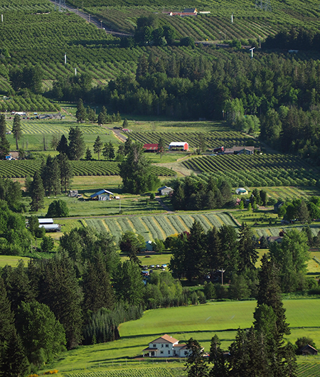
Timeless farm scene below Middle Mountain

Much of Middle Mountain is owned by the public, where county-owned forest lands continue to be (mis)managed as a cash register by Hood River County (the county likes to refer to these land as their “tree farm”). Local residents no doubt enjoy their modest tax rates, as a result, but I’m hoping the rapidly changing demographics in Hood River will bring a different mindset to how the thousands of acres of county forests that ring the Hood River Valley are managed.

05cMiddleMountainLogTruckSign

Logging is still king on Middle Mountain…

One immediate concern on Middle Mountain is the manner of logging. Large clear cuts, like those scarring the slopes of Middle Mountain, are an unsustainable practice, with proven harmful impacts to forest health, water quality and salmon and steelhead populations. Clear cuts are also the cheapest, easiest way to bring haul logs out of the forest. That bottom line might be unavoidable for private forests, but as a public agency, Hood River County should at least adopt a selective harvest policy that leaves standing trees in logged areas.

05dMiddleMountainLogTruck

…keeping Hood River County coffers full…

The county should also reject the reckless use of herbicides sprayed on logged over lands. This is a practice the private industry uses to shortcut the natural forest recovery and speed up the next harvest. The idea is to destroy the recovering forest understory in a logged area so that plantation seedlings might grow a little faster.

05eMiddleMountainTimberSaleBoundary

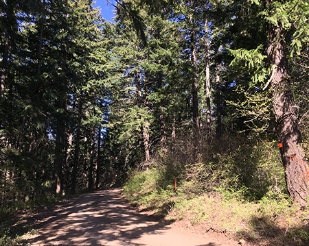
The forest on the left is next to go…

I’m not certain the county uses this practice on public lands, but it seems to be the case. Consider this notice posted a few days ago on their website:

“Recreation trails are sometimes temporarily closed during additional forest management operations. Operations such as the burning of slash, herbicide application, and the planting of seedlings, will necessitate trail closures. Trails are re-opened once operations are complete.”

This certainly sounds like the private industry practice…

05fMiddleMountainTimberSaleBoundarySign

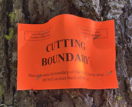
…might as well add “for now” to the last line on this boundary marker, unfortunately.

Of course, the county could show real leadership and simply ban this practice on private lands in Hood River County, as well. That is, if water quality, wildlife, salmon and steelhead habitat, long-term forest health and tourism are a county priority over the fastest route to clear cutting more logs. My sense is that voters in Hood River County are increasingly focused on these broader concerns, even if the county leadership isn’t there yet.

06aShotgunFallsPortrait

June features Shotgun Falls in the Molalla River canyon

[Click here for a large image]

For the June calendar image, I selected another lesser-known spot, graceful Shotgun Falls (above) in the Molalla River canyon. This pretty, off-trail waterfall has been on my list for some time, and the Gorge closure inspired me to finally make this trip last spring for a much-needed waterfall fix.

06bShotgunFallsBase

Shotgun Falls

Shotgun Falls is a classic “Oregon” waterfall, cascading over a tall, mossy basalt cliff. The falls is a short creek walk from the Molalla River Road, but protected by a 20-foot barrier falls just downstream that requires a slippery scramble to navigate. It’s an increasingly popular off-trail trip, and the streambed is starting to show the wear and tear, making this a great candidate for a proper trail that families with young kids and hikers looking for an easy waterfall trip could enjoy. More to come on this idea..!

06cShotgunFallsSlopeDamage

Time for a real trail, here…

Sometimes a random moment burns a place and time in the forest into your memory. One such moment occurred on my trip to Shotgun Falls when my pack suddenly tipped while shooting photos from high above the falls. To my horror, it went bounding into the canyon, finally stopping just short of Shotgun Creek, about 60 feet below. Thankfully, my camera gear was safely zipped inside and I didn’t even end up with a soggy pack — the difference between a fond memory and forgettable one!

06dShotgunFallsTomsDroppedPack

Takes a licking, keeps on zipping!

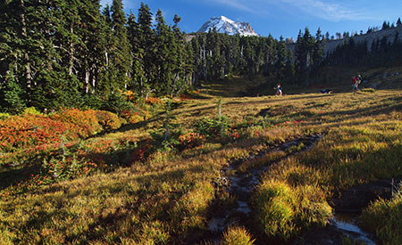
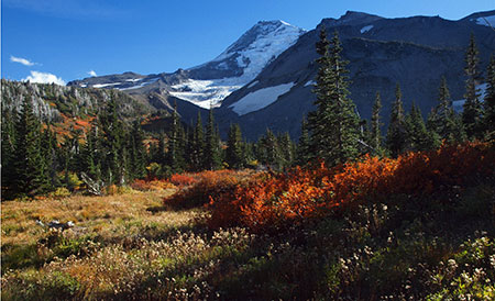
The July calendar image features a picture-perfect wildflower scene along Cove Creek (below), located at the base of Barrett Spur in Elk Cove. This idyllic spot is kept open by a deep, lingering snowpack in spring and regular winter avalanches that shear off trees, allowing the alpine meadows to thrive.

07aCoveCreakBarrettSpur

July features Cove Creek and Barrett Spur

[Click here for a large image]

Looking downstream along Cove Creek (below), 99 Ridge can be seen in the distance, covered with ghost trees killed by the 2012 Dollar Lake Fire. The fire reached the margins of Elk Cove, but passed over most of the forests here.

07boveCreekAdams99Ridge

The Dollar Lake Burn swept over 99 Ridge, in the background in this view of Cove Creek

On this trip to Elk Cove, I met a pair of hikers carrying their exhausted pup down the trail. When I chatted briefly with them, I was reminded that hikers are really nice people: they didn’t even know each other. The man carrying the dog had run into the woman as she struggled to carry her dog back to the trailhead. He offered to carry the poor pup the rest of the way!

07cVistaRidgeHikersCarryingDog

Hikers are nice people! (…see text…)

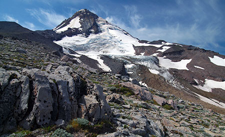
For the August calendar image, I selected a familiar view of Mount Hood from high on the shoulder of Cooper Spur (below). The Eliot Glacier dominates the view here, even as it recedes from global warming. As the glacier recedes, the exposed canyon floor once covered by ice has rapidly eroded, which in turn has  begun to destabilize the moraines that flank the canyon.

08aHoodEliotGlacierPortrait

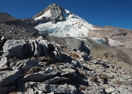
August features the mighty Eliot Glacier

[Click here for a large image]

I experienced the hazards of the destabilized moraines firsthand when I stopped along the South Eliot Moraine that day and set my pack on a 4-foot long boulder that seemed to be the perfect trailside bench. Before I could park myself on the “bench”, it suddenly gave way, careening end-over-end into the Eliot Branch canyon, kicking off dozens of other rocks and an impressive dust storm along the way!

08bEliotMoraineDustCloud

The south Eliot Moraine continues to crumble…

Thankfully, there were no hikers below — and I was also relieved that I’d snapped up my pack before the boulder disappeared over the edge! Clearly, my pack has nine lives… though I’m not sure how many remain…

08cEliotMoraineBoulderRollEliotBranch

Seeing the boulder finally land among the jumbled rocks 300 feet below was powerful reminder of the scale of this place, as the 4-foot “bench” rock was dwarfed by dozens of larger boulders scattered below the moraine.

08dEliotMoraineBoulderRoll

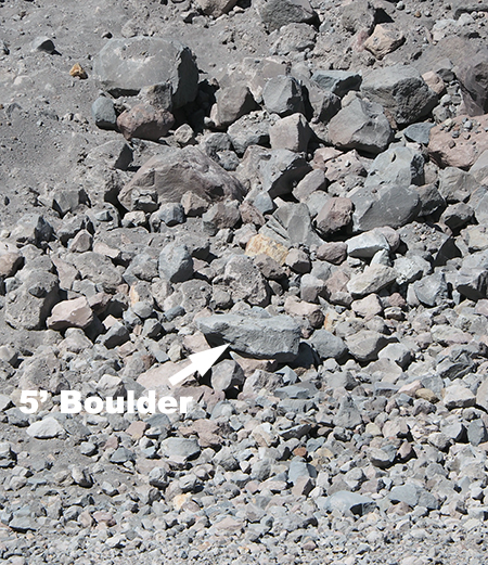
A 4-foot boulder becomes a pebble among the debris rolling into the Eliot Branch canyon

The September calendar image captures fall colors along Still Creek, on Mount Hood’s southwest side. This photo was taken on a visit to a recent Forest Service project designed to restore salmon and steelhead habitat on Still Creek.

09aAutumnForestStillCreek

September features a grove of Red Alder along Still Creek wrapped in brilliant Vine Maple foliage

[Click here for a large image]

The project site was a badly overused “dispersed” campsite that had become an eyesore over the years. To rehabilitate the site, the Forest Service excavated a large trench to block vehicle access to the streamside campsite, reinforced the barrier with a row of boulders. So far, these barriers seems to be working, as there were no signs of continued camping or off-road vehicle use in the area.

09bStillCreekRestoration

Forest Service stream restoration work on Still Creek

At the heart of the restoration project, several very large logs with root wads attached (below) were hauled into the stream to create the natural “woody debris” habitat that our native salmon and steelhead rely upon. The logs and roots create deep pools and places for small fish to hide from predation as they mature to adulthood.

09cStillCreekRestoration

Bringing back logs and root wads that create prime fish habitat

There’s something primeval about uprooted trees lying across the creek. This is what most of our streams looked like before the settlement era, when forests were logged, streams were tamed and few big trees were left to become “woody debris”. The panorama below shows the full extend of this Forest Service restoration project.

09dStillCreekRestoration

Panoramic view of the restoration site

[Click here for a large image]

On a select few days each fall, the first high elevation snow of the season is followed by a few days of bright, clear weather — and with any luck, all of this coincides with fall colors. Such was the case in the calendar image I selected for October (below), with Mount Hood framed by flaming Vine Maple, as viewed from the Lolo Pass area.

10aHoodLoloPassRoadFallMaples

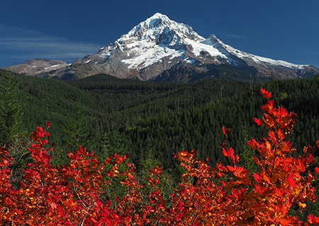
October features an early snow on Mount Hood, framed by Vine Maples

[Click here for a large image]

Whenever I shoot this scene, an image of a scalloped-edge vintage postcard is in my mind. Thanks to many postcards from the 1940s, 50s and 60s that captured this side of the mountain in autumn, the scene is iconic. This card (below) from the 1950s is typical of the era, and was captured just around the corner from where I shot the 2019 calendar image.

10bLoloPassPostcard

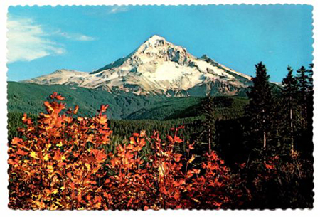
Timeless inspiration, with fancy scalloped edges!

For the November calendar image, I selected a rainforest scene from along the Molalla River (below), where bare winter trees reveal the contorted, mossy limbs of Bigleaf and Vine Maple.

11aMolallaRiverRainforestMossyGlen

November features a pristine rainforest scene along the Molalla River

[Click here for a large image]

While the above certainly scene looks pristine, it’s really not. One of my favorite photographic themes is to capture “pristine” scenery in places that are not — but could be, if managed with an eye toward restoration. Such was the case with the previous photo from Lolo Pass, where transmission towers were literally buzzing overhead, and with the Molalla River, where a road culvert dumped the little stream in the photo from a 4-foot galvanized pipe.

11bMolallaRiverMile8CreekCulvert

…which turns out to not be all that pristine..!

Beauty can be found everywhere, and the path to restoration in even the most impacted areas in WyEast country begins when we see places not just for what they once were, but for what they could be, again.

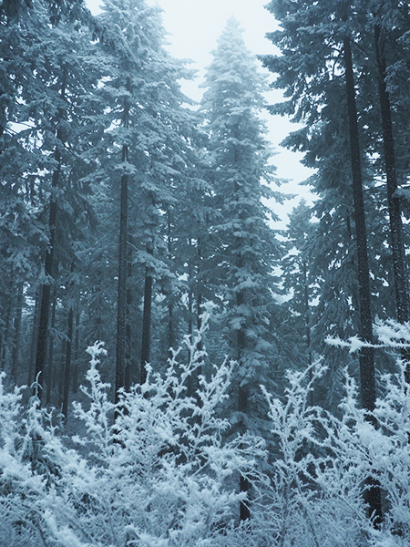
The December calendar image is a freezing fog scene from the east slopes of Mount Defiance (below). This stunning phenomenon occurs a few times each winter when temperature inversions blanket the eastern Columbia River Gorge with dense fog and frigid temperatures. The effect is magical, though traveling the roads in these conditions can be treacherous!

12aBinnsHillFrostForest

December features a crystal wonderland from freezing fog on the slopes of Mount Defiance

[Click here for a large image]

The frosting of ice coating the forest in these scenes is called “soft rime”, and is made up of feathery, fragile crystals that can be brushed off like a fine powder. Soft rime forms when super-cooled vapor in fog accumulates directly on tree surfaces in delicate, elaborate crystals. Hard rime is defined as ice forming from freezing fog that first condenses to water droplets, then freezes on surfaces, creating a clear, hardened ice layer.

12bKingsleyFrostForest

Freezing fog on Mount Defiance

Soft rime accumulations can be quite impressive in the Gorge, depending on how long the fog event lasts. These scenes were captured after five days of freezing fog and represent about the maximum amount of ice that can accumulate before crystals break off under their own weight.

12cKingsleyFrostForest

Freezing fog on Mount Defiance

This photo (below) is a close-up of soft rime accumulations on a Golden Chinkapin growing on the slopes of Mount Defiance. These crystals as much as three inches long.

12dFrostedChinkapin

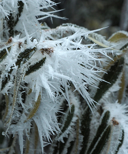
Soft rime ice crystals

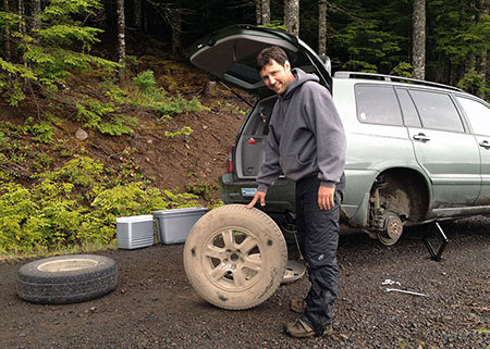
The scene below shows an odd transition from bare road (and car) to frosted forest that looks like a photoshop creation. In this spot the rime had coated the trees and understory, but not the gravel road in the foreground, creating the strange two-tone scene. This photo is also a bit of a farewell, as my venerable trail car of the past many years years is featured. This old friend was retired to quiet a life in the city just a few months after this photo was taken, at the ripe old age of 13 years and 212,000 miles!

12eKingsleyFrostForestToyota

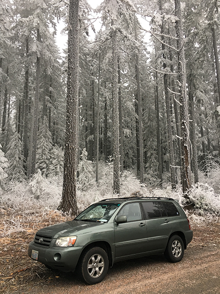
Farewell to an old friend…

The back page of the 2019 calendar features nine wildflower images from the past year. If you’ve followed articles on the blog, you’ll recognize a several photos featured in stories on Horkelia Meadow and Punchbowl Falls.

From top left and reading across, these flowers are Hackelia micrantha (Horkelia Meadow), Chocolate Lily (Punchbowl Falls Park), Oregon Iris (Shellburg Falls), Buckwheat (Horkelia Meadow), Calypso Orchid (Punchbowl Falls Park), Oregon Grape (Molalla River), Horkelia fusca (Horkelia Meadow), Collomia grandiflora (Clackamas River) and Skyrocket Gilia (Horkelia Meadow).

13BackCover2019

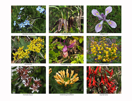
A year in wildflowers!

[Click here for a large image]

So, that’s it for the 2019 campaign calendar! I’ve already started colleting images for next year’s calendar and I’m looking forward to yet another year of exploring all corners of America’s next national park. Maybe I’ll even see you out on the trail!

14ShotgunFallsTom

Old goat that wandered up a creek…

In the meantime, you can order the 2019 calendar over at Zazzle. They’re beautifully printed, oversized designs with functional writing space — they’re working calendars and make great gifts! The calendars sell for $29.95, but Zazzle regularly offers deep discounts, so it’s worth watching for sales. This year, all proceeds from calendars will go to Trailkeepers of Oregon (TKO).

You can order a 2019 campaign calendar here

Thanks for reading this far, and I hope you’re able to get out and explore Mount Hood and the Gorge over the holidays!

_______________

Tom Kloster  •  December 2019

2015 Calendar… and looking back on 2014!

The view from Owl Point is the cover image for 2015

The view from Owl Point is the cover image for 2015

Each year since 2004 I’ve published a wall calendar dedicated to the special places that make Mount Hood and the Gorge a national treasure — and of national park caliber! You can pick one up for $30 at the Mount Hood National Park Campaign store at CafePress, and you’ll also be supporting the campaign website and this blog when you do!

The following is a preview of the calendar images I picked for the 2015 edition, along with some backstory behind the photos. All of the photos were taken from November 2013 through October 2014. Part of the challenge each year is to come up with 13 new calendar-worthy images, which in turn ensures that I get out on the trail and poke around my favorite haunts, plus a few new spots whenever I can!

For January, I picked a close-up view of the upper Sandy Glacier and the towering cliffs of the Sandy Headwall. This view came from an early snowfall last winter, one of several trips I made to the Bald Mountain and McGee Ridge:

January features the upper Sandy Glacier and towering Sandy Headwall

January features the upper Sandy Glacier and towering Sandy Headwall

On one of those trips to the McGee Ridge viewpoint, I had just set up my camera and tripod along the Timberline Trail when a pair of climbers came down from the mountain. They were obviously not typical hikers, and soon I realized that they were the explorers I had just written a blog article about! “Sandy Glacier Caves: Realm of the Snow Dragon!” was written partly in anticipation of the Oregon Field Guide 2013 premiere episode that featured the glacier Caves… and my new trail acquaintances, Brent McGregor and Eric Guth.

Look closely, and you can see Eric and Brent's boot prints in the snow near the Snow Dragon cave

Look closely, and you can see Eric and Brent’s boot prints in the snow near the Snow Dragon cave

Brent and Eric pointed out several features around the glacier caves from our vantage point. I was later able to add a postscript to the original article to elaborate on some of the new details about their discovery that I learned that day on the trail.

Eric Guth and Brent McGregor on the trail in 2013

Eric Guth and Brent McGregor on the trail in 2013

I’ve also been able to help Brent with his historic research on the formation of the glacier caves with a series of images I’d taken of the Sandy Glacier since the early 2000s. I’ve photographed the glacier in detail pretty much every year for more than a decade, mostly because of it’s scenic beauty, so it was great to discover a more practical use for all those photos!

For February, I picked a photo from a memorable winter day on Mount Defiance (below) after a bank of freezing fog had settled in on the mountain for several days. Nearly every surface was covered with long, beautifully developed ice crystals that had grown undisturbed in the almost still air of the freezing fog layer.

February features a frosty forest on the slopes of Mt. Defiance

February features a frosty forest on the slopes of Mt. Defiance

On that frosty day, I also stopped to photograph the sign shown below on the way up to Mount Defiance, as it showed amazing insight and precision by the Hood River County road department in deciding where to stop plowing!

Winter wonderland ahead!

Winter wonderland ahead!

For March, I picked a scene from the Pacific Crest Trail where it climbs along the west rim of the White River canyon. This section of trail is also part of the Timberline Trail, and is surprisingly overlooked, given the views and close proximity to Timberline Lodge.

March features the White River Canyon from the Pacific Crest Trail

March features the White River Canyon from the Pacific Crest Trail

I posted an article in 2011 on the buried forests that can be seen here. The deeply carved maze of ravines that make up the White River canyon are cut into volcanic debris from the Old Maid eruptions that occurred from 1760 to 1810, and subsequent erosion has revealed some of the well-preserved trees that were buried in these eruptions. The 2011 article describes how to view these old specimens.

I also enjoyed watching a lenticular cloud form over the mountain in the hour or two that I sat on the canyon rim that evening last winter — one of my favorite mountain phenomena. You can see just the beginning of the cloud over the summit in the calendar view, and the tiny sliver later blossomed into the classic lenticular cloud shown in the view below, as I was packing up for the day:

Lenticular cloud forming over The Mountain

Lenticular cloud forming over The Mountain

Lenticular clouds typically form when moist air from approaching weather fronts is compressed as it passes over the big volcanoes in the Cascade Range. They often form as much as a day before the cloud bands of a Pacific front actually arrive, so are a useful barometer of changing conditions.

For April, I picked something a little different: a desert scene just a few miles east of the mountain, where the same White River that originates from its namesake glacier in the previous scene flows east into the rugged rimrock country of Oregon’s High Desert, shown below:

April features the lower falls at White River Falls State Park

April features the lower falls at White River Falls State Park

Over the millennia, the White River has carved through many layers of Columbia River basalt to form its desert canyon, but as it approaches the confluence with the Deschutes, the river encounters an especially tough series of basalt layers. The result is the spectacular White River Falls, a misty green emerald in the desert, protected in a small state park.

The lower falls pictured in the April image is about one-half mile downstream from the main falls, and well off the popular trail in the area. The calendar image is actually just a cropped portion of a very wide panorama (below) that captures more of the rugged scene at the lower falls.

Original jumbo-pano that the calendar image was cropped from

Original jumbo-pano that the calendar image was cropped from

The scoured bedrock in the foreground of this view is testament to volatile nature of the White River: seasonal floods regularly surge to this depth, engulfing the floor of the canyon.

In another 2011 article titled “Close Call at White River Falls”, I described the threats to this magnificent area, and why it deserved better protection — perhaps someday a unit of Mount Hood National Park?

The old powerhouse at White River Falls

The old powerhouse at White River Falls

In addition to the natural scenery, the canyon is home to the fascinating ruins of an early 1900s hydroelectric plant. Desert weather has helped preserve the many relics in the area, but arid conditions haven’t prevented vandals from taking an increasing toll on priceless historic resources.

The powerhouse is amazingly well-preserved inside

The powerhouse is amazingly well-preserved inside

Hopefully, we can someday stabilize the White River Falls site and preserve the remaining traces of history for future generations to explore.

For May, I chose another unusual image for a Mount Hood National Park calendar: Middle North Falls on Silver Creek. Why? Mostly because what we now know as Silver Falls State Park was once proposed to become a national park in the 1920s! It would have been a terrific addition. The scenery, alone blows away many of the existing national parks monuments in our park system!

May features the famous Middle North Falls on Silver Creek

May features the famous Middle North Falls on Silver Creek

Alas, the national park proposal failed after a National Park Service study deemed the logged-over landscape of the 1920s too ravaged to be worthy of park status. Thankfully, that didn’t stop the Civilian Conservation Corps in the 1930s from building the elaborate, magnificent trail system and beautiful South Falls Lodge (listed on the National Historic Register in 1983) that we still enjoy today.

The national park idea for Silver Falls resurfaced again in 2008, when Oregon State Senator (then Representative) Fred Girod proposed it during a special session. Notably, Dr. Girod is a Republican from Stayton, representing the Senate district that encompasses Silver Falls State Park, so maybe we’ll see the idea resurrected in the future? I like that maverick thinking, Senator!

Trail ranger leading a kids hike at Silver Creek -- how very cool!

Trail ranger leading a kids hike at Silver Creek — how very cool!

On the visit last spring when I photographed Middle North Falls, I was reminded that Oregon’s state parks do a pretty good job of embracing the national park tradition at Silver Creek when a young ranger appeared, leading a group of youngsters on a day hike. Kudos to Oregon Parks and Recreation Department for providing programs like these!

Could Silver Falls State Park become a unit of a future Mount Hood National Park? Why not! One tangible benefit would be the opportunity to expand the footprint from the current park boundaries to include the rest of the upper watershed of Silver Creek. The park more than doubled in size in 1958, when a federally funded expansion added in a portion of the headwaters, bringing the park to the present size of just over 90,000 areas.

The amazing, national-park-quality amphitheater behind North Falls

The amazing, national-park-quality amphitheater behind North Falls

Yet, heavy logging and large private inholdings upstream continue to impact Silver Creek stream with silt and algae blooms. These impacts could easily be reversed if the upper watershed were managed for conservation and recreation, instead — especially if the park were expanded to include the upper watershed and its associated habitat.

For June, I picked an image of Butte Creek Falls, a nearby cousin to Silver Creek located even closer to Mount Hood, within the Santiam State Forest. Like Silver Creek, the upper watershed of Butte Creek is heavily logged, with some obvious sediment and algae in the stream as a result.

June features Butte Creek Falls

June features Butte Creek Falls

Also like Silver Creek, the health of Butte Creek could be turned around with a shift to managing for conservation and recreation. Unlike Silver Creek, most of the lands in the upstream watershed are already held in the public trust by the State of Oregon.

Unfortunately, our state forests are held captive by a legislature determined to log them to feed the state general fund — and to ensure that rural counties that already pay only a fraction of the property taxes levied in other parts of Oregon aren’t inconvenienced with paying for their own schools.

Therefore, the best way to restore Butte Creek would be to transfer it to Oregon Parks and Recreation Department as a very large state park… or incorporate it into a future Mount Hood National Park! At a minimum, it’s time for the Santiam State forest to focus on restoring forests and protecting watersheds, not just future timber sales.

Always travel with an automotive repair expert!

Always travel with an automotive repair expert!

The behind-the-scenes, somewhat embarrassing story that goes with the Butte Creek Falls image is one of my hiking buddy Jamie Chabot helping change a flat tire after our trip to Butte Creek and nearby Abiqua Falls. We managed to take a couple of wrong turns in the maze of logging roads and clearcuts that surround the small preserve containing Butte Creek: at some point, I jumped out to survey the canyon below to figure out where we went wrong… only to hear a HISSSSSSS coming from one of the rear tires!

There was no room to pull off to the side, so we were in the awkward predicament of having the car up on a jack in the middle of an active logging road. Fortunately, we were able to install the spare before a loaded log truck came barreling our way! My belated apologies to Jamie for doing the heavy work while I took pictures… but somebody had to document the episode for posterity!

Jamie was also my hiking companion on a couple of trips to Owl Point last summer. This has been an annual favorite of mine since a group of volunteers from the Portland Hikers forum rescued the Old Vista Ridge from being lost to official Forest Service neglect in 2007.

Each year, the trail seems to get better, thanks to a lot of unofficial TLC from anonymous trail tenders. Today, the Old Vista Ridge trail is in great shape and now forms the boundary of the expanded Mount Hood Wilderness, so in that sense has been etched into legal permanence. Hopefully, it will eventually make it back onto the Forest Service inventory of officially maintained trails, a status it clearly deserves.

July features Mount Hood from Owl Point

July features Mount Hood from Owl Point

There are now several geocaches and a trail log tucked along the historic old trail, and it’s amazing to see how busy the area has become now that it has been featured in several popular hiking guides (including Williams Sullivan’s “100 Hikes in Northwest Oregon” and Paul Gerald’s “60 Hikes within 60 Miles of Portland”).

One trail log had more than 60 entries for just 2014, including this wonderful entry from a young family introducing their kids to the adventures of hiking and exploring the Mount Hood backcountry at a very young age:

My favorite Old Vista Ridge trail log entry… ever..!

My favorite Old Vista Ridge trail log entry… ever..!

One of my favorite experiences on the trail is seeing young families introducing their junior hikers to our public lands, battered field guides in hand. Just like my own formative experiences just a few decades ago.

For August, I picked an image from another of my favorite spots, just off the Cooper Spur trail, above the lower extent of the Eliot Glacier. This image was taken on one of those days when clouds were wrapped around the mountain for much of the day, but suddenly cleared for a few minutes — just long enough to capture a few photos before the mountain disappeared, once again:

August features the Eliot Glacier on Mount Hood's north flank

August features the Eliot Glacier on Mount Hood’s north flank

I certainly do not mind sitting on the shoulder of the mountain waiting out the clouds (there’s no such thing as a bad day on the mountain, after all!), but a bonus during this wait was learning a new bird species (to me), as a pair of these small birds (below) stopped by to check me out:

Horned lark at Cooper Spur

Horned lark at Cooper Spur

This is a horned lark, a wintertime migrant to our area, and the pair I saw had likely arrived recently when I spotted them last August. The Portland area actually has a year-round resident population of streaked horned larks, which look similar to horned larks and are a threatened species. These are details I learned after the trip from the helpful folks at the Portland Audubon Society.

According to Audubon staff, horned Larks are widespread songbirds of fields, deserts, and tundra, where they forage for seeds and insects, and sing a high, tinkling song — and thus were quite at home in the tundra conditions of Mount Hood’s high east side. Though they are considered common, they have undergone a sharp decline in the last half-century. Their very generalized range map shows them wintering from the Cascades west and breeding in summer in Canada tundra/steppe terrain.

For September I picked an image from Wyeast Basin, taken toward the end of a lovely early autumn day as a family and their dog ambled across the sprawling meadow. Wyeast Basin is remarkable for the surprising number of springs bubbling up from the mountain slopes and racing one another downhill, often just a few feet apart.

September features early autumn colors at WyEast Basin

September features early autumn colors at WyEast Basin

While this view (above) from the calendar is the familiar scene at WyEast Basin, I also turned my tripod around to capture the web of springs and streamlets flowing north toward the big Washington volcanoes, on the distant horizon. The talus slopes of Owl Point can also be seen in the distance from here, just above the tree line.

The view north to Owl Point and the Washington Cascades from WyEast Basin

The view north to Owl Point and the Washington Cascades from WyEast Basin

For October, the scene is from Elk Meadows, perhaps the most photogenic of the string of alpine meadows on Mount Hood’s rugged north side. In this view, the Coe Glacier tumbles below the summit, and 7,853-foot Barrett Spur looms darkly on the left. Avalanches roll off Barrett Spur in winter, sometimes with devastating effect on the alpine forests below, as the many bleached snags and stumps in Elk Cove suggest.

October features beautiful Elk Cove in autumn

October features beautiful Elk Cove in autumn

My companions for the Elk Cove hike this fall were Jamie Chabot and Jeff Statt. I met both when Trailkeepers of Oregon (TKO) was founded in 2007: Jeff was the founding president of the new non-profit, and Jamie the original creative force behind the TKO logo, Portland Hikers calendars and the TKO web identity.

Tom, Jamie & Jeff enjoying a little slice of paradise at Elk Cove

Tom, Jamie & Jeff enjoying a little slice of paradise at Elk Cove

Both Jeff and Jamie continue to support TKO after all these years as the organization continues to grow, and we still meet up for periodic trail stewardship projects together. I’m honored to have them as trail friends, and having them along on this hike made it extra-special!

For November, I picked a familiar view of Triple Falls on Oneonta Creek, taken during an especially wet week in the Gorge. Normally, the somewhat muddy runoff in this scene would be a deal-killer for photos, but I came around to the idea that in this case, it told the story of swollen Cascade streams during the stormy months of late autumn rather nicely, so added it to the mix.

November features a swollen Triple Falls on Oneonta Creek

November features a swollen Triple Falls on Oneonta Creek

I was memorably soaked on the hike to Triple Falls, not because rain is particularly unique in the Gorge, but because I had just re-ducked my trusty canvas hat (for waterproofing)… but had left it drying in the oven, at home! I discovered this fact at the Oneonta trailhead, so circled back to the Multhnomah Falls lodge to see what sort of hats were in stock.

It turns out that baseball caps are the ONLY option at the Multnomah Falls lodge — and I HATE baseball caps! (primarily because they don’t fit all that well on my basketball-sized head..!) Well, at least I could support my alma mater, and I hit the trail $20 poorer with a ridiculous, ill-fitting beanie that (sort of) kept my large, bald head dry…

You would hate baseball caps, too, if you had a basketball-sized head like mine…

You would hate baseball caps, too, if you had a basketball-sized head like mine…

Once on the trail, I also ran across one of the most extensive landslides to form in recent years, cutting away a 100-foot swath of the Oneonta Trail along a steep canyon section. Trail crews had constructed a temporary crossing of the slide, but just a few days after that trip in November, the slide claimed more ground, erasing the temporary trail. Such is the ongoing challenge of keeping trails open in the very active landscapes of the Gorge and Mount Hood!

A rip-roaring Oneonta Creek after the first big autumn storms

A rip-roaring Oneonta Creek after the first big autumn storms

For December, I picked a late fall image of Elowah Falls, taken from one of the long-bypassed viewpoints along the original Civilian Conservation Corps route described in this recent article on McCord Creek.

December features a wide pano of Elowah Falls on McCord Creek

December features a wide pano of Elowah Falls on McCord Creek

Photographing a 213′ waterfall at close range means a wide-angle lens and blending some images. In this case, I merged three vertical images taken with my 11mm lens to create the panoramic view. This is my first time photographing from this spot, and I will definitely return!

By now you’ve been introduced to my trail buddy Jamie, and on the way out from Elowah Falls that day I ran into Jamie and his two boys! They were headed toward the upper falls on McCord Creek on that very busy hiking day in the Gorge. It was great to see Jamie passing on the hiking tradition to boys!

Jamie and his rugged boys hitting the trail at McCord Creek

Jamie and his rugged boys hitting the trail at McCord Creek

That’s it for the 2015 Mount Hood National Park Campaign calendar highlights, and now for a few thoughts on the blog…

Thanks for another year!

I launched the WyEast Blog in 2008 as a simpler way to promote Mount Hood and the Gorge as “national park-worthy” than updates to the project website would allow. And though I didn’t post quite as often this year for a whole variety of reasons (mostly, real life getting in the way), I was amazed to see the readership for the WyEast Blog continue to grow in 2014.

Yours truly taking in the first big snowfall on Mount Hood in early November

Yours truly taking in the first big snowfall on Mount Hood in early November

In early 2014, the monthly page views edged above the 5,000 mark for the first time, and jumped well above that mark during the peak hiking months of spring and summer. More importantly, the list of official blog followers has grown steadily to 141 this year. These are the true Mount Hood and Gorge junkies that I have in mind when I post to the blog, and these are also the folks who send me both nice notes and periodic corrections — both are greatly appreciated!

I posted a total of 14 articles this year, down a bit from previous years, but bringing the six-year total to 136 articles. I’ve also got a bunch of new articles in the oven, ready to post when time allows. So, the WyEast Blog will be around for awhile!

The two most popular articles continue to be:

10 Common Poison Oak Myths (2012)

Ticks! Ticks! (10 common myths) (2013)

The “ticks” article has been viewed 38,147 times since I posted it in 2013, and the poison oak piece 21,545 times — sort of amazing! But these numbers have validated my obsession with providing thorough, detailed, geek-worthy articles that are more in the magazine format than typical blog fare.

Taking in the fall colors at Butte Creek

Taking in the fall colors at Butte Creek

So, enough facts, figures and anecdotes: if you’ve read this far in my annual, somewhat (ahem!) self-indulgent post, THANK YOU for being a reader… and most importantly, thanks for being a friend of Mount Hood and the Gorge!

See you on the trail in 2015!

Tom Kloster
WyEast Blog

2013 Mount Hood National Park Calendar

Each year at about this time I assemble the Mount Hood National Park Scenic Calendar. The proceeds are modest, but do help support the Mount Hood National Park Campaign website, WyEast Blog and related project expenses. But the main purpose is to simply promote the national park concept, and make the case for the campaign with pictures.

What the calendar looks like – oversized 11×17” pages you can actually use!

I’ve published the calendars since 2004, so this year’s calendar marks the ninth edition. All of the photos in the calendar are from trips and trails I’ve explored over the past year. I get a surprising number of questions about the photos, so in addition to simply announcing the 2013 calendar, this article tells a bit of the story behind the new images — and some are surprising!

The 2013 Scenes

The cover image for the 2013 calendar is Upper McCord Creek Falls, located just west of Cascade Locks. This is a popular destination for Columbia Gorge lovers, though often overshadowed by its more famous downstream sibling, Elowah Falls.

Cover Scene: Upper McCord Creek Falls

Upper McCord Falls is unique in that it flows as a twin cascade. A little known fact is that a third segment used to flow during the rainy season as recently as the 1970s, just to the left of the two segments shown in the photo (above). The third segment has since been blocked by stream debris, however, so for now, Upper McCord is best known as a twin cascade.

The falls is popular with photographers, but in 2010 was briefly obstructed by a large treetop that had split from atop a nearby maple, landing perfectly on its head, directly in front of the falls. While the local photography community simply grumped and groaned about this unfortunate development, Gorge waterfall explorer and photographer Zach Forsyth did something about it: he scrambled down the slope, and neatly tipped the 40-foot up-ended tree on its side. Thus, Zach made this year’s calendar cover possible – thanks, Zach!

Upper McCord Creek Falls with “the stump” in 2010

Upper McCord Creek Falls is tucked away in the hidden upper canyon of McCord Creek, just a few hundred yards from the brink of Elowah Falls. The trail to the upper falls is especially spectacular, following a ledge chiseled into sheer cliffs in the early 1900s to pipe water to the former Warrendale Cannery, below (portions of the pipe system can be seen along the trail). The falls is hidden from view until you abruptly arrive at the dramatic overlook, directly in front of the falls – one of the finest and most unexpected scenes in the Gorge.

The January calendar scene is a wintery view of the rugged west face of Mount Hood, just emerging from the clouds after a fresh snowfall. This view was captured just a few weeks ago near Lolo Pass, as the evening light was briefly catching the summit.

January Scene: West face after an early winter storm

Like most “mountain in the mist” images, this one was a reward for patience: I waited for two chilly hours for the clouds to clear! It worth the wait, though I’ve also had my share of disappointments when that glorious glimpse of the mountain didn’t materialize.

For the month of February, I picked an image from a trip last winter along the Little Zigzag River. I had planned to snowshoe to Little Zigzag Falls from the Kiwanis Camp, but there were only about 18 inches of snow on the ground, much of it fluffy and new. So, I simply trudged through leaving some very deep boot prints in my wake — and happily, the only footprints on the trail that afternoon.

February Scene: Little Zigzag River in winter

The weather was extremely cold on this visit, revealing one of the surprising effects of running water in winter: it turns out the sheer volume of relatively “warm” water (that is, above freezing) flowing down the Little Zigzag river actually heats the narrow canyon, much like an old steam radiator heats a room.

Following this radiator analogy, the temperate gradient is most noticeable when air temperatures are really cold. It was about 12º F that day, yet the air right next to the stream, and especially in front of Little Zigzag Falls measured in at a “balmy” 30º F. I found myself peeling off layers while shooting the stream and falls, only to hurriedly put them back on as I ventured back down the trail and into the real cold!

For the month of March I chose another waterfall scene, this time the lush, verdant base of popular Latourell Falls in the Columbia Gorge.

March Scene: Latourell Falls in spring

On this visit to the falls, Oregon State Parks construction crews were starting work on several major upgrades to viewpoints along this busy trail. As a result, the most popular trailhead at the Latourell Wayside was closed. Instead, I took a back route to the falls and had the place to myself for the better part of an hour — nearly unheard of on what should have been a busy spring weekend at Latourell Falls.

The April calendar scene is from Rowena Plateau at the McCall Preserve, in the dry, eastern Columbia Gorge. The iconic yellow balsamroot and blue lupine were in peak bloom on this sunny afternoon in mid-spring, and the glassy surface of the Columbia River in the background reveals a rare day of calm in the normally windy Gorge. The very tip of Mount Adams peeks over the hills on the horizon, on the Washington side of the river:

April Scene: Balsamroom and lupine on Rowena Plateau

The trip to Rowena was especially memorable for me, as I was hiking with an old college friend who was visiting Oregon for a few days. Rowena was a great place to catch up on news and old memories.

My friend also happens to be an eminent geologist working for the federal government, so we had a great conversation about the mystery of “desert mounds” (also known as “biscuit scablands”), which found on Rowena Plateau and in other areas in the Columbia Basin (watch for a future WyEast Blog article on this subject…).

Hikers passing one of the mysterious desert mounds on Rowena Plateau

Continuing the balsamroot-and-lupine theme, the May scene in the new calendar comes from Hood River Mountain, a tract of private land that is (for now) open to the public, but at risk of closure, due to heavy use by hikers.

This is one piece of land that will hopefully come into public ownership someday, before a less responsible private owner places trophy homes on these beautiful slopes. I wrote about this unfortunate oversight in the Columbia River Gorge Scenic Act in this article from a few years ago.

May Scene: Hood River Mountain in May

On Memorial Day last spring, I made a trip to Dry Creek Falls, a beautiful waterfall saddled with one of the most unfortunate and uninspiring place names in the Gorge! The June calendar image is from that trip, and captures Dry Creek rambling through the forest a few hundred yards below the falls.

June Scene: (not so) Dry Creek in spring

This area has a unique history: an old, derelict diversion dam and waterworks survives at the base of the falls, where the City of Cascade Locks once tapped the stream for municipal water in decades past. Perhaps this is the origin of “Dry Creek” name — did the stream below the diversion actually go dry when the dam was installed? Perhaps, but today it flows year-round, and makes for a beautiful streamside hike in spring.

Dry Creek Falls and the remains of the old diversion dam and waterworks

The July scene in the 2013 calendar is from a trip to Elk Cove last August. This is one of my annual pilgrimages, and I have photographed this particular spot just east of Cove Creek too many times to count — yet I’m always excited to get there, and recapture the stunning scene.

July Scene: Summer wildflowers at Elk Cove

The wildflower bloom on Mount Hood was delayed by several weeks this year, so even though I was a bit late in visiting Elk Cove, there was still a bumper-crop of purple aster mixing with the blue lupine and mop-heads of western anemone, or Old Man of the Mountain.

Not visible in the calendar view of Elk Cove are the blackened forests directly behind me: the Dollar Fire of 2011 swept across a 5-mile swath along the northern foot of Mount Hood, charring the northern fringes of Elk Cove, including several large stands of mountain hemlock that frame the view from 99 Ridge.

The Dollar Fire burned a 5-mile swath across the north slope Mount Hood

Though it’s initially shocking to see healthy forests killed by fire, it is also part of the natural cycle of forest renewal. Thus, we’ll now have a front-row seat to the fire recovery process that will unfold over the coming years along the popular north side trails. I wrote this blog article on the Dollar Fire earlier this year.

For the August calendar image, I picked a less familiar scene from an otherwise popular hike: the soaring trail to the 8,514’ summit of Cooper Spur. To beat the crowds, I set my alarm for 3 AM and raced to the trailhead at Cloud Cap. I was the first to arrive at the string of dramatic viewpoints along the trail, and caught the first rays of sun lighting up the northeast face of the mountain.

August Scene: Eliot Glacier from Cooper Spur

This view is from the north shoulder of Cooper Spur, just below the summit, and looking into the impressive jumble of crevasses and icefalls along the Eliot Glacier. Though the sky was crystal clear (you can see the moon setting to the left of the mountain), the winds from the south were strong and blustery. So, getting this shot from the lee side of the spur also meant enjoying some respite from the intense wind and blowing volcanic grit.

For the September image, I selected a lesser-known view of the mountain: the remote and rugged Newton Canyon, on the southeast side, where Mount Hood has a broad, massive profile.

September Scene: Rugged Newton Creek Canyon on the east side of Mount Hood

Glacial Newton Creek is best known for the havoc it brings far below, where the stream has repeatedly washed out Highway 35 with violent debris flows that toss Toyota-size boulders and whole trees across the road in their wake. Construction crews were busy this summer completing yet another repair, this time for damage that occurred in the 2006 floods. As always, the new road is bigger and higher than the old. We’ll see if Newton Creek is persuaded to flow through the new series of larger flood culverts this time…

The October scene is from Wahclella Falls on Tanner Creek, a popular family hike that also provides terrific viewing of spawning salmon and steelhead in early autumn.

October Scene: Wahclella Falls in autumn

Fall colors were somewhat muted in 2012, thanks to an unusually long, dry summer that extended well into October. As a result, the broadleaf trees in many areas had already dropped a lot of leaves due to the stress of the drought, before they would even have a change to change with the seasons.

While fall colors at Tanner Creek were less affected by the summer drought, the autumn scene in this year’s calendar has to make due without without the help of the particular tree, the Wahclella Maple I wrote about earlier this year. You can see the hole it left by comparing this year’s image (above) and a 2010 image (below).

Wahclella Falls in 2010 with the Wahclella Maple still standing above the footbridge

Since 2007, I’ve made annual trips with friends and volunteers to tend to the Old Vista Ridge Trail on the north side of Mount Hood. This historic gem from the early 1900s was an overgrown, forgotten victim of the Forest Service clear-cutting juggernaut for some 40 years, but somehow managed to escape their chainsaws.

Volunteers re-opened the Old Vista Ridge Trail in 2007, spurred in part by a Forest Service scheme to turn the area into a playground for dirt bikes and ATVs — an appalling plan that was eventually abandoned, in part because the rediscovered trail had revealed the beauty of the area to so many.

In 2010, the trail became the official northern boundary of the expanded Mount Hood Wilderness, when President Obama signed a new wilderness bill into law. This change should close the door on future Forest Service threats to the area, and today the hike into one of the best on the mountain.

November Scene: Mount Hood from Owl Point

The November calendar scene is from a viewpoint along the Old Vista Ridge Trail known as Owl Point, the rocky outcrop with stunning views of the mountain. Bright red huckleberries light up the foreground in this scene, and the first dusting of snow highlights the mountain. In the distance, you can also pick out the browned forests on the slopes of Mount Hood, where the Dollar Fire swept across the base of the mountain in 2011.

The final image in the new calendar is another taken from Lolo Pass, perhaps one of the most spectacular views of Mount Hood. This image was taken just before sundown after a fresh snowfall had blanketed the mountain.

December Scene: Winter arrives at Lolo Pass

I paid the price for taking in the sunset that night at Lolo Pass, as my car was broken into at the trailhead – something I’d somehow managed to avoid in all my years of hiking! As frustrating as it was to deal with the repairs and lost belongings… I’d do it all over again just to spend those magical hours watching the mountain that night — it was truly breathtaking! Here, take a closer look, and see for yourself:

Mount Hood from Lolo Pass | 2012
_________________

The thirteen images I chose for the 2013 calendar are from a few thousand images I’ve taken this year on something just shy of 40 outings to Mount Hood and the Gorge — a bit less time on the trail than a typical year would allow, but no complaints! As always, these adventures took me to new places and discoveries, as well as fond visits to my favorite old haunts.

And as always, the magnificent scenery further confirmed my conviction that Mount Hood should (and will!) be set aside as our next National Park! Hopefully, the calendar makes the case, as well.

How can you get one, you ask?

The new calendars are available online:

2013 Mount Hood National Park Calendar at CafePress

They are large and functional, measuring 17” across by 22” tall when hung, with plenty of room for writing notes and scheduling activities. CafePress packages them carefully, with each calendar sealed against a corrugated cardboard backing for support.

The calendars sell for $29.99 + shipping, with about 25% of the proceeds going to support the Mount Hood National Park Campaign. They make terrific stocking stuffers (…although you’ll need an 11×17” stocking…), and CafePress now makes it even easier by offering PayPal as an option.

And as always, thanks for your support!
_______________________________________

Addendum: Gorge uber-Guru Scott Cook set me straight on a couple of comments in the above article:

Hey Tom, so of course I read your blog like a good Gorge denizen. A couple of points…I’m not trying to sound like a know-it-all…but I know that you do like to get at the bottom of things and eschew conjecture:

The pipes visible on the Upper McCord trail are from Myron Kelly’s pulp mill, not Warren’s cannery. There are some pix on my blog of Kelly’s mill and iterations of his pipes. I have another old pic too showing the pipe running along the cliff cleft, illustrating to me that the cleft was a pipeway instead of a WPA/CCC construction.

2013MHNPCalendar16
(author’s note: here’s a photo I shared with Scott that shows CCC crews clearing out the old waterline shelf to make way for the trail to Upper McCord Falls — note the Historic Columbia River Highway, far below, and the CCC crew bosses in full uniform)

…and, about Dry Creek falls, the Creek was called Dry Creek before the water works were installed. The reason is that just downstream of the PCT trail bridge, just down the access road 200yards, the creek dries up in the summer to nothing, just a dry creek bed as the creek goes subterranean until re-emerging downstream of the powerline corridor.

If you walk down the access road in the summer, the stream is of course flowing under the bridge, but when you walk downstream the sound goes away and you just figure the stream curved away from the road, but nope, if you bushwhack over just 100 feet you’ll see the dry stream…as you will if you continue down the access road also.

Down the (Dry Creek) access road is a bunker-looking building that was built in the 30’s to store the water from the stream’s waterworks for the city’s first municipal supply. The water shed is still in use today, but the water is pumped upwards into it from wells in the town below.

Next edition of Curious I’ll have Dry Creek Falls as a loop using the powerline access road…so people can learn the history and see the Dried-up Creek as well (cuz everyone loves a loop). Look for my pix on Google Earth of all this stuff and the dried-up creek. -Scott

Thanks, Scott!

Let’s Fix the Cooper Spur Trail

The first hiking trails on Mount Hood were built in the late 1890s, radiating from the newly constructed Cloud Cap Inn on the mountain’s north side. The steep hike up the south Eliot Glacier moraine to Cooper Spur was perhaps the first trail, as it was part of the still-popular Cooper Spur route to the summit. The original climber’s trail is still used, though a much gentler route built in the 1960s now ascends the spur in a series of well-graded switchbacks.

The new, graded trail carries thousands of hikers to the top of Cooper Spur each summer. It is among the most spectacular alpine hikes in the country, with jaw-dropping views of the sheer north face of Mount Hood and a close-up look at the massive jumble of flowing ice that makes up the Eliot Glacier.

The snowfields in question on Cooper Spur are permanent enough to be mapped.

It’s hard to know exactly why the newer, graded trail was routed over a set of mostly permanent snowfields when it was built, but this design flaw continues to be a problem for this otherwise exceptional trail. The newer trail initially follows the climber’s route fairly closely, sticking to the rim of the Eliot Glacier where the snow melts early and reliably each summer.

But near the crest of Cooper Spur, the newer route suddenly crosses the face of the spur, traversing to the south shoulder and overlooking the Newton Clark Glacier. It is in this section where the route crosses a set of persistent snowfields that are nearly permanent in all but the driest years.

The snowfields clearly show up in this 1890s view of Mount Hood in late summer.

This flaw in the newer route is confusing and potentially dangerous to the many hikers who venture to the top of the spur each summer. At 8,514 feet, the summit of Cooper Spur is truly alpine, so one of the benefits of the modern trail is to provide a relatively manageable hike to the top of the spur for the average visitor, despite the high elevation.

But when the trail disappears into the snow in this final pitch, hikers often resort to climbing directly up the snowfield — a dangerous choice — or scrambling up the steep climber’s trail, with its loose rock and cinders creating a potentially dangerous option for many hikers.

The snowfields as viewed from Cloud Cap Inn in the late 1890s.

The design flaw in the newer route may also have environmental impacts: the climber’s trail isn’t really a “trail”, but rather, a braided confusion of boot paths made less stable and more extensive each year as the popularity of the Cooper Spur hike continues to grow.

Early 1900s maps don’t show the snowfields, but they do show the climber’s trail on Cooper Spur.

While the ecological impact might seem inconsequential at this elevation, where few plants can even survive, the physical scars left on the rocky slopes are real and warrant better management of recreation travel in the area.

The high tundra landscape on the slopes of Mount Hood represents one of the most unusual and sensitive in the region, and a stray boot print can last for years. The ever-increasing variations on the climber’s trail that form each summer can take years to recover, even if given the chance.

The USGS 7.5 minute maps of the 1960s were the first to map the snowfields as permanent features. This 1962 map pre-dates the modern Cooper Spur Trail.

This article makes the case for addressing this problem in a couple of steps:

1. Realign the upper portion of the Cooper Spur Trail with a series of designed, graded switchbacks that roughly follow the climber’s trail, along the Eliot Glacier rim.

2. Decommission the problem sections that are usually snow-covered.

This proposal would not only corral the hiking hordes onto a more manageable, new path near the climber’s route, it would also leaves the bulk of the east slope of Cooper Spur untouched by hikers by decommissioning the old trail. This could greatly reduce the impact of the trail on the alpine ecosystem that exists on the slopes of Cooper Spur.

[Click here for a larger version of this map]

One of the most attractive aspects of this proposal is that it would be so easy to build. Building trails at this elevation, with the absence of soils and vegetation, is straightforward and very simple. The new route would simply need to be designed and surveyed, with construction done by volunteers or youth crews like the Northwest Youth Corps.

Looking up the climber’s trail to Cooper Spur and Mount Hood.

Trail construction would consists of rolling loose boulders and rocks to form a trail bench, and smoothing the surface of the new bench into a hiking tread with the abundant volcanic ash and glacial till that makes up most of the terrain at this elevation. This work is relatively easy, and surprisingly fast (I know this firsthand because I’ve adopted a couple of nearby trails in the area, and regularly rebuild worn trail segments in this high-elevation environment of rock and ice).

How to Help

If you’ve experienced the same frustration coping with the trail to Cooper Spur, your comments to the U.S. Forest Service can have an impact. This proposal represents a fairly simple effort, and there’s a good chance the Forest Service will respond if enough hikers weigh in on the hazards of the current trail alignment.

The best way to be heard is to go to the Mount Hood National Forest contact page and speak your mind — it’s easy, and you might just help get this trail fixed for generations to come!

Proposal: Cooper Springs Trail

Cairns with cedar posts mark the way on the slopes below Cooper Spur.

One of the memorable highlights along the Timberline Trail is the starkly beautiful section between Gnarl Ridge and Cloud Cap, high on the broad east shoulder of the mountain. Here, the trail crests its highest point, at 7,335 feet, as it traverses the tundra slopes of Cooper Spur more than a thousand feet above the tree line.

However, the spectacular elevation of the Cooper Spur section is also its Achilles heel, since hikers attempting the Timberline Trail must cross a series of steep snowfields here. In most years this entire section is snowed in through late July, and some sections of trail appear to be permanently snow-covered.

Looking north along the Timberline Trail along the slopes of Cooper Spur

The trail builders constructed a series of huge cairns to mark the way through this rugged landscape, yet the snowfield crossings continue to present both a risk and route-finding obstacle to most hikers, especially in early summer. The Timberline Trail continues to draw hikers from around the world in ever-growing numbers, so an alternative route seems in order to ensure that the around-the-mountain experience continues to be world class for all visitors.

The Proposal

To provide a more reliable alternative for this segment, a new, parallel trail is proposed as part of the Mount Hood National Park Campaign. The new route would be about a mile to the east, at roughly the 6,200’ level, just below the tree line. For early season hikers, or simply those not up to the rugged combination of elevation, rock and snow on the existing trail, this new route would provide a more manageable alternative.

This new 3.5-mile route would still connect Cloud Cap to Lamberson Butte, but at a lower elevation. As shown on the map below, the proposed Cooper Springs Trail (in red) would depart from the current Timberline Trail (in green) at the current Cooper Spur junction on the north, and rejoin the Timberline Trail just below Lamberson Butte, to the south.

Click here for a large map

This option would add about a half-mile to the around-the-mountain trip, but would also save about 800’ of elevation gain, as measured in the traditional clockwise direction on the Timberline Trail. In fact, the new Cooper Springs Trail would actually drop 200’ in elevation from Cooper Spur Junction to Lamberson Spur.

This new trail wouldn’t be a formal segment of the Timberline Trail, but simply a hiking option, just as other parallel routes to the Timberline Trail already allow at Umbrella Falls, Paradise Park, Muddy Fork and Eden Park.

Today, these complementary routes along other sections of the Timberline Trail not only allow for interesting loops and less crowded conditions for hikers, they also provide detour options when trail closures occur — as happened recently along the Muddy Fork, where hikers were able to use a parallel route to avoid washouts on the main trail.

What Hikers Would See

The northern segment of the new Cooper Springs Trail would make a gradual descent from the existing 4-way junction of the Cooper Spur, Tilly Jane and Timberline trails to the tree line, curving through a series of small headwater canyons that eventually feed into Polallie Canyon. This section would cross the first of several small streams along the new route.

The northern section of the new trail from above the Timberline Trail, as viewed from the slopes of Cooper Spur.

Click here for a large map

Soon the new route would cross a sharp ridge, where under this proposal it would intersect with an extension of the Lamberson Spur Trail. This trail is an odd anomaly: the route is marked and maintained where it leaves the Cold Spring Creek Trail, but mysteriously dies out on a ridge about a mile below the tree line. A few adventurous hikers continue cross-country from this abrupt terminus to the Timberline Trail each year, but under this proposal, the Lamberson Spur Trail would be formally connected to the new Cooper Springs Trail. This new segment is shown in yellow on photo schematic, above.

Extending the Lamberson Spur route to the new Cooper Springs Trail would entail about a mile of new trail, but would be an important piece in linking the new Cooper Springs route to the existing network of trails along Cold Spring Creek and Bluegrass Ridge, to the east. Together, this network of trails could provide an important, less crowded overnight or backpacking experience than is possible on the more heavily visited sides of the mountain.

Beyond the proposed Lamberson Spur junction, the middle section of the new Cooper Springs Trail would pass through an especially interesting landscape. Here, a series of dramatic cliff-edged bluffs and talus slopes frame the view of Mount Hood and Cooper Spur, looming above, while the trail would cross through groves of ancient mountain hemlock.

The middle section of the new trail would traverse a series of little known canyons and cliff-topped bluffs below Cooper Spur.

Click here for a large map

This section of the new trail would also provide a close-up look at the aftermath of the Gnarl Fire, which burned a large swath of forest along the eastern base of the mountain in the summer of 2008.

At one point, the fire made headlines when it threatened to destroy historic structures in the area, narrowly missing the venerable Cloud Cap Inn. Though the trail would traverse above the burn, it would allow hikers to watch the recovery phase of the fire cycle unfold on the slopes, below.

Finally, in the southern section the proposed Cooper Springs Trail would traverse through dozens of rolling lupine meadows, gnarled stands of whitebark pine and mountain hemlock and unique views of the massive east face of Mount Hood and the surrounding wilderness.

The southern section of the new trail would weave through a series of little-known alpine meadows, near Lamberson Butte.

Click here for a large map

In this section, the proposed trail would traverse the slopes of Cooper Spur at the point where a series of tributaries to Cold Spring Creek emerge and flow eastward through a maze of steep canyons. The springs are continuously fed by several permanent ice fields on Cooper Spur, and thus would be a reliable water source for hikers — and are also the namesake for the proposed trail.

The new route would then rejoin the Timberline Trail just below Lamberson Butte.

What it Would Take

The proposed Cooper Springs Trail (and Lamberson Spur extension) would be entirely within the Mount Hood Wilderness, and thus must be built without the add of motorized equipment.

Normally, this presents a major obstacle to trail construction, since a typical trail requires the removal of trees and vegetation down to mineral soil — a formidable task in the rainforests of the western Cascades, even with the aid of chainsaws and power tools. However, the slopes of Cooper Spur consist mostly of soft, sandy soils, loose rock, scattered trees and open meadows, so construction of the 3.5 mile trail would be much less cumbersome with hand tools here than in other parts of the forest.

One of the Northwest Youth Corps crews that worked the Timberline Trail in 2009.

There are a number of organizations that might be interested in helping build the trail, but perhaps the most promising would be the Northwest Youth Corps, an organization that has sent crews of young people to restore wilderness trails around Mount Hood for many years.

Finally, it would take a renewed commitment from the Forest Service to expand the trail network around the mountain, and this is the largest obstacle. The agency has been doing just the opposite for many years, allowing trails to fade into oblivion for lack of basic maintenance.

But this is also where you can help: the Forest Service has the funding to provide more trails, yet needs strong public support to make trails a priority in agency budgets. Buying a forest pass simply isn’t enough, unfortunately.

Make your opinion known, and don’t accept the “lack of funding” explanation. Instead, take a look at this comparison of funding for Mount Hood and a couple of well-known national parks, and simply ask that YOUR forest to be managed with trail recreation at the top of the priority list.

How can you contact them? Just click here to send them an e-mail!

Hiroshima Rock Centennial (1910-2010)

Hiroshima Rock and Mount Hood

Today marks the centennial of a Japanese climbing expedition to the summit of Mount Hood on July 17, 1910. The achievement would probably be forgotten by now, except for the visitors carving a record of their ascent into a glacier-polished andesite boulder at the crest of Cooper Spur.

The boulder is now informally known as “Hiroshima Rock”, and a familiar feature to generations of hikers and climbers who have since passed this spot.

Detail of Hiroshima Rock

Little is recorded about the expedition, even in the gold standard of Mount Hood history — Jack Grauer’s Complete History of Mount Hood — though the arrival of a Japanese climbing expedition surely must have been reported in the local press of the time. Lacking that written history, what follows is my own speculation on the climb.

The inscription contains both English and Japanese text, and supposedly the Japanese portion identifies the expedition as originating from Hiroshima. It is not surprising that a Japanese expedition would seek out Mount Hood. Mountain climbing had blossomed as a sport in Japan in the late 1800s, just as it had in Europe and the United States.

But the Japanese interest in climbing mountains had deeper roots, dating back centuries to the earliest spiritual pilgrimages to mountain peaks — most notably, Fujiyama.

“The Pilgrimage” captures the long Japanese tradition of mountain climbing for spiritual purposes

It is therefore not surprising that a group who had likely climbed Mount Fuji numerous times was drawn to Mount Hood, on the opposite side of the Pacific. Both peaks are part of the Pacific “Ring of Fire”, and share a common volcanic origin. Yet, Mount Hood would have been a more technical climb, with its steep, deeply eroded slopes and tumbling glaciers.

It is also likely that the Japanese party stayed at Cloud Cap Inn, or at least stopped there, since the inn was still operating in 1910, under the management of Horace Mecklem, and would have likely been snow free in mid-July. At the time, the Cooper Spur route was the most popular ascent, since Cloud Cap Inn provided the best access to the mountain.

Traditional Japanese spiritual quest to Fujiyama

Given the very active climbing schedule of the Mazamas in the early 1900s, it is also likely that the Mazamas were involved in the Japanese expedition, or at least aware that a group from Japan was on the mountain.

The Japanese expedition likely used similar climbing tools to what Europeans and Americans employed at the time: layered clothes, knapsacks and alpenstocks. The photos below are LIFE archival images from the late 1940s that capture the look and feel of Japanese climbs just after the war. These images probably give a fair sense of what the 1910 climbers must have looked like.

Japanese climbing expedition on Fujiyama in 1948

Japanese climber on Fujiyama with Lake Kawajuchi in background in 1948

The second image from the LIFE series is interesting in that it shows the climber wearing traditional Japanese tabi, or toe shoes (see detailed view, below). Modern tabi are still widely worn today in Japan, and as anyone who hikes knows, modern toe shoes are a popular new trend in the U.S., too.

Detail showing a Japanese climber wearing tabi, or toe shoes

So, why did the expedition carve their record into the rock on Cooper Spur? The most obvious explanation is simply posterity, since it was common in that era to carve your legacy into rocks or trees in a way that we would find unacceptable today.

But a more intriguing possibility might be that that expedition was holed up on Cooper Spur, perhaps stalled by bad weather, or simply setting up a base for the final ascent. This might explain the time it would have taken to chisel the Hiroshima Rock message into a very hard chunk of andesite — an effort that would likely take hours to complete.

For now, the details appear to be lost in time. But the legacy of the inscription is an elegant reminder that attraction of Mount Hood drawn visitors from around the world from the very beginning, and still does.

Postscript

Chiyoko & friends celebrating at Cooper Spur (Photo Courtesy Guy Meacham)

Just after posting this article, I learned that Guy and Chiyoko Meacham led a group up to Hiroshima Rock on July 18, 2010 to celebrate the centennial (plus one day) and Chiyoko’s birthday (to the day). After cake and champagne, Chiyoko translated the Kanji inscriptions to read:

Left side: Mie Ken Jin – Ito (Person from Mie State, [Mr.] Ito)

Right side: Hiroshima Ken Jin (Person from Hiroshima State)

English portion:

July 17th 1910
Monument
[Mr.] S. Takahashi

You can read the entire trip report and see their beautiful photos over at the Portland Hikers site: click here