WyEast Bats Last: The White River Saga Continues!

Mount Hood and the White River as it appeared early in the summer of 2020

Mount Hood’s glaciers may be retreating, but if anything, the melting ice and more extreme weather that climate change is bringing to the mountain have only made the streams that emerge from its glaciers that much more volatile. 

Glacial streams are inherently intimidating: ice cold and rising dramatically within hours when glacial melting accelerates on hot summer days to become churning river of mud and silt. They can make for terrifying fords for Timberline Trail hikers and wreak havoc on downstream roads and streambanks. But the worst events typically come in fall or late spring, when sudden warming and heavy rain can trigger rapid snowmelt on the mountain, turning these streams into unruly torrents.

Highway 35 was buried under a sea of boulders in the November 2006 White River debris flow (ODOT)

Such was the setting in November 2006, when a warm front with heavy rains pounded the mountain, rapidly melting the first snows of autumn that added to the explosive runoff. The worst damage to infrastructure came from the raging White River and Newton Creek, two glacial streams that emerge from the southeast side of the mountain. The streams also happen to flank the Meadows ski resort, so when both streams effortlessly swept away whole sections of the Mount Hood Loop highway (OR 35), the resort suddenly found itself cut off from the rest of Oregon.

The 2006 floods washed away the bridge approaches and stacked boulders eight feet deep on top of the former White River Bridge (ODOT)

Highway worker posing with a boulder dropped by the White River on the centerline of Highway 35 during the 2006 floods (ODOT)

Oregon Department of Transportation (ODOT) crews quickly restored temporary access to the resort, but the damage to the highway was profound. Newton Creek had simply swept away the roadbed along an entire section of the highway, while the White River had swept away the bridge approaches on both sides of the concrete span over the stream – then proceeded to pile a collection of boulders on top of the stranded bridge, just for emphasis! 

This overflow culvert at the east end of the old bridge approach was overwhelmed in the 2006 flood, as the White River spilled over the top of the highway, instead (ODOT)

Undaunted, the highway engineers at ODOT and the Federal Highway Administration turned to a recently completed 2003 study of design solutions for several flood-prone spot along the Highway 35. From these, a pair of projects totaling $20 million were proposed to finally tame the two streams – a “permanent” fix, as the study described it.

East of the White River, the 2006 floods also sent a torrent of water and debris down Newton and Clark Creeks, erasing sections of Highway 35 near Hood River Meadows (ODOT)

Once again, the plan was to go bigger. For Newton Creek, the now rebuilt highway includes a massive, 30-foot wide, rock-lined flood channel running parallel to the highway, with box culverts periodically spaced to allow floodwaters to cross under the road. For the White River, a series of option were considered, including a tunnel (!) and completely relocating the highway. But in the end, the option of simply replacing the older span with a much larger bridge was selected. The new bridge was completed in 2012.

Options considered in the 2003 study of possible Highway 35 crossings of the White River

[click here for a larger version of this table]

The preferred option for the White River also included a second span over Green Apple Creek, a small stream located just east of main crossing, and a feature that would serve as an overflow for the White River. Between the bridges, the new highway crossing is constructed on a high berm of fill, twenty feet above the expanse of sand and boulders that make up the White River floodplain, and berms also support the approaches to both bridges on either side of the floodplain.

When they were completed in 2012, six years after the floods that had swept away sections of the highway, these structures seemed gargantuan compared to the previous incarnation of the highway. Yet, looking down upon the new White River Bridge from higher up on the mountain, it is really nothing more than a speed bump for the raging monster the White River is capable of.

The White River has been moving east for several years. This view is from early summer 2020, when the upstream section of the river had already moved almost to the east canyon wall

For the past decade, the new structures seemed to be working as planned by the highway engineers. The White River continued to meander about in its wide flood channel, as it has for millennia, but it still found its way to the newer, bigger bridge opening. Until last winter, that is.

Sometime during the winter of 2020-21, the river abruptly formed another new channel along the east side of its floodplain, beginning about one mile above the new highway bridge. In recent years, the river had been gradually moving in this direction, including a smaller flood event in the fall of 2020 that spilled debris into the White River West SnoPark. Today’s radically new channel is a continuation of this eastward movement, almost to the east wall of the canyon. 

This view from the fall of 2020 followed a debris flow that sent rock and gravel into the White River West SnoPark and set the stage for the big shift in the river’s course that would follow over the coming winter. The river was actively meandering across the latest flow in this view, settling on a new course

The berm in the center of this view was built after the 2006 floods to project the White River West SnoPark parking area (on the right) from future flooding (the White River floodplain is on the left). The fall 2020 debris flow managed to breach the berm, spreading rock and gravel across the southern corner of the parking area (the third car and most distant car in this photo is parked on the debris). The new (and now dry) White River Bridge is in the distance

By the spring of 2021, the White River had completely abandoned the main floodplain and now flows beyond the row of tress in the far distance

Looking downstream from the new White River Bridge in 2021, the former riverbed is now completely dry, with the river now flowing beyond the band of trees on the left

The White River Bridge is only a few years old, but now spans only a dry streambed

This decision to include a second bridge in the new design turned out to be fortuitous over the last winter, at least in the near term. This “overflow” bridge is now the main crossing of the recently relocated White River. Had ODOT opted to simply replace the culverts that once existed here, the river would have easily taken out a section of the berm that supports the highway between the two new bridges, closing the highway, once again. However, the second span is much smaller than the main span, so it is unclear whether the river will continue to cooperate with the highway engineers and stick to this unplanned route.

This view shows the new channel carved by the White River sometime during the winter of 2020-21

The White River carved a 20-foot-deep riverbed through loose floodplain material to form the new channel

The new bridge design included this secondary opening as a backup to the main bridge, though it is now the primary crossing of the relocated White River. The highway slopes downward as it moves east of here, dropping below the elevation of the White River floodplain, and thereby creating the potential for the river to migrate further east, threatening the fill section of the highway in the distance in this view

The channel shifts on the White River might seem to be sudden, but in reality, they are perpetual. The White River (along with the rest of Mount Hood’s glacial streams) bring tremendous loads of rock and silt with them. This has always been the case, with melting glaciers releasing debris caught up in the river of ice, some of it building piles of rock called moraines, and some carried off by the rivers that flow from the glaciers.

In the past few decades, the cycle of glacial erosion has been compounded by the retreat of the glaciers, themselves. All of Mount Hood’s glaciers are rapidly losing ice in the face of a warming climate, and the retreat of larger glaciers like the White River, Eliot, Sandy and Coe leaves behind bare ground once covered in ice. 

When this happens, and erosion shifts from slow-moving ice to fast-running water, the amount of debris and water moving down the glacial streams grows dramatically. The following diagram (see below) explains this relationship in the context of the rapidly retreating Eliot Glacier, Mount Hood’s largest body of ice, located on the mountain’s northeast side.

[click here for a larger version of this schematic]

Glaciers plow wide, U-shaped valley as they grind away at the mountain, whereas streams cut deep, V-shaped canyons. When glaciers like the Eliot retreat, they expose their u-shaped valleys to stream erosion, and their outflow streams (in this case the Eliot Branch) immediately go to work cutting V-shaped canyons into the soft, newly exposed valley floor, resulting in much more material moving downstream in more volatile events.

In the schematic, the lower part of the Eliot Glacier is somewhat hidden to the casual eye, as it’s covered with rock and glacial till. This is true of most glaciers – the white upper extent marks where they are actively building up more ice with each winter, and the lower, typically debris-covered lower extent is where the ice is actively melting with each season, leaving behind a layer of collected debris that has been carried down in the flowing ice.

The terminus of the glacier in the schematic marks the point where the Eliot Branch flows from the glacier. As the terminus continues to retreat uphill with continued shrinking of the Eliot Glacier, more of the U-shaped glacial valley floor is exposed. At the bottom of the schematic, the floor of the valley has been exposed for long enough to allow the Eliot Branch to already have eroded a sizeable V-shaped canyon in the formerly flat valley. This rapid erosion has fed several debris flows down the Eliot Branch canyon in recent years, including one as recently as this month, abruptly closing the road to Laurance Lake. 

The Eliot Branch continues to spread debris flows across its floodplain, burying trees in as much as 20 feet of rock and gravel. This section of the Eliot Branch flooded again earlier this month, closing the only road to Laurance Lake

We’ve seen plenty of examples of this activity around the mountain over the past couple of decades, too. In 2006 the mountain was especially active, with flooding and debris from the Sandy, Eliot, Newton Clark and White River glaciers doing extensive downstream damage to roads – this was the event that removed the highway at the White River and Newton Creek. Smaller events occurred in 1998, as well. In the 2006 event, the Lolo Pass Road was completely removed near Zigzag and the Middle Fork Hood River (which carries the outflow from the Eliot and Coe glaciers) destroyed bridges and roads in several spots.

Even in quieter times, the White River has moved its channel around steadily. That’s because the heavy debris load in the river eventually settles out when it reaches the floodplain, filling the active river channel. This eventually elevates the river to a point where it spills into older channels or even into other lower terrain. Because of the broad width of the White River floodplain at the base of the mountain, this phenomenon has occurred hundreds of times over the millennia, and the river will continue to make these moves indefinitely. 

To underscore this point, the 2003 highway study of potential solutions for Highway 35 includes this eye-opening chart that shows just how many times the White River has flooded the highway or overtaken the bridges – nearly 20 events since the highway was first completed in 1925!

[click here for a larger version of this timeline]

Therein lies the folly of trying to force the river into a single 100-foot opening (or even a second overflow opening) on a half-mile wide floodplain. The fact that much of the floodplain is devoid of trees is a visual reminder that the river is in control here, and very active. It has a long history of spreading out and moving around that long precedes our era of roads and automobiles.

But the White River has an added twist in its volatility compared to most of the other glacial streams that flow from Mount Hood. The vast maze of sandy canyons that make up the headwaters of the White River are quite new, geologically speaking – at least as they appear today. This is because of a series of volcanic events in the 1780s known as the Old Maid eruptions covered Mount Hood’s south side with a deep blanket of new volcanic debris. The same gentle south slopes that Timberline Lodge and Government Camp sit on today didn’t exist before those eruptions, just 240 years ago.

The White River Glacier (center) flows from near the crater of Mount Hood, and rests upon soft slopes of rock and ash debris that were created by the Old Maid eruptions of the 1780s. The large rock monolith poking up from the crater (left of center) is Crater Rock, an 800-foot lava dome that formed during the Old Maid eruptions

The Old Maid eruptions created other new features on the mountain – notably, 800-foot Crater Rock, a prominent monolith that was pushed up from the south edge of the crater. Meanwhile, the eruptions also generated lahars, the name given to sudden, massive mudflows that can range from ice cold to boiling, depending on the origin of the event. These flows rushed down the White River, Zigzag and Sandy River valleys, burying whole forests under debris ranging from mud and silt to boulders the size of delivery trucks.

The Old Maid eruptions take their name from Old Maid Flat, located along the Sandy River, where a new forest is still struggling to take hold on top of the volcanic debris, more than two centuries later. At the White River, trees buried by the lahars can be seen in the upper canyon, where the river has cut through the Old Maid eruption debris to reveal the former canyon floor, and trees still lying where they were knocked over (more about those buried forests toward the end of this article).

From high on the rim of the White River canyon, the endless supply of rock and ash from the Old Maid deposits is apparent – along with the impossibly tiny (by comparison) “bigger bridge” over the White River

This telephoto view of the new White River bridge from the same vantage point in the upper White River canyon reveals the structure to be a mere speed bump compared to the scale and power of the White River

For this reason, the White River has an especially unstable headwaters area compared to other glaciers on the mountain, with both glacial retreat and the unstable debris from recent lahars triggering repeated flash floods and debris flows here. That’s why the question of whether the new, bigger and bolder highway bridge over the White River will be washed out is more a question of when. It will be, and in our era of rapid climate change, the answer is probably sooner than later.

Is there a better solution? Perhaps simply acknowledging that the river is perpetually on the move, and designing the road with regular reconstruction in mind, as opposed to somehow finding a grand, permanent solution. That’s at odds with the culture of highway building in this country, as it could mean simply accepting more frequent closures and more modest bridge structures – perhaps structures that could even be moved and reused when the river changes course?

The 2003 Federal Highways study actually acknowledges this reality, even if the brawny, costly designs that were ultimately constructed in 2012 do not:

“It is imperative to remember that geological, meteorological, and hydrological processes that result in debris flows, floods, and rock fall have occurred for millions of years, and will occur for millions of years to come. They are naturally occurring phenomena that with current technology cannot be completely stopped or controlled. Thus, the best that can be hoped for is to minimize the destructive, highway– closing impacts of events at the study sites.” (FHWA Highway 35 Feasibility Study, 2003)

The White River seems to be enjoying its new channel and change of scenery…

In the meantime, the newly relocated White River an awesome sight. We’re so accustomed to bending nature to our will in this modern world that it’s refreshing to see a place where nature has no intention of being fenced in (or channeled, in this case). 

Do rivers have a sense of humor or experience joy? As I looked down upon the White River sparkling and splashing down its new channel this summer, it seemed to be thoroughly enjoying the pure freedom of flowing wherever it wants to. It’s yet another reminder that “nature bats last”, and in WyEast country, the mountain – and its rivers — will always have the final word. 

For us, it’s that strangely comforting reminder that we’re quite insignificant in the grand scheme of things, despite our attempts to pretend otherwise.

How to visit the White River

If you’re interested in experiencing the living geology of the White River, an easy introduction is to park at the White River West SnoPark area and trailhead, then head up the trail toward the mountain for a quarter mile or so. From here, the river has moved to the far side of the floodplain, but for the adventurous, it’s cross-country walk across sand and boulders to reach the stream. There, you can soak your feet in ice cold, usually milky water and watch the river moving the mountain in real time, pebble-by-pebble. The main trail is almost always within sight, so it would be tough to get lost in the open terrain here.

Look closely – those tan stripes near the bottom of the White River canyon mark the pre-Old Maid eruption slopes of Mount Hood, now buried under ash and debris from the lahars. Several preserved trees that were knocked down by the eruption can be seen along these margins. This viewpoint is along the Timberline Trail, just east of Timberline Lodge.

To see the relocated White River, park at the White River East SnoPark and walk to the east bridge – now the main crossing of the White River. The view upstream includes the top of Mount Hood, but watch out for speeding traffic when crossing the highway!

To see the buried White River forest, you can park at Timberline Lodge and follow the Timberline Trail (which is also the Pacific Crest Trail here) east for about a mile, where the trail drops to the rim of the upper White River canyon. The views here are spectacular, but if you look directly below for a waterfall on the nearest branch of the White River, you’ll also see the reddish-yellow mark of the former valley floor and the bleached remains of several ghost trees buried in the eruptions 240 years ago. Watch your step, here, and stay on the trail – the canyon rim is unstable and actively eroding!

___________________

Tom Kloster | July 2021

Ski Traffic & the Loop Highway: Part 2

The winter weekend crush of skiers is nothing new on Mount Hood

The winter weekend crush of skiers is nothing new on Mount Hood

(This is the second in a two-part article. The first part focused on the latest plans to add more parking to the Meadows resort, another step in the wrong direction for Mount Hood, but one that (unfortunately) has already been approved by the U.S. Forest Service. This part focuses on the future, and a promising new strategy that seems to finally be turning the page on an era when ODOT and the Mount Hood ski resorts simply paved their way out of weekend traffic problems with more parking and wider highways.)
__________________

Since the early days of developed snow sports on Mount Hood in the 1920s, winter weekend traffic jams have been the norm. The cars have changed (and so has the highway, regrettably), but the same bottlenecks appear in pretty much the same spots, as thousands of Portlanders pour into the ski resorts over a few short winter weekends each year.

Intrepid auto tours reached Government Camp on dirt roads years before the loop highway was completed in the early 1920s

Intrepid auto tours reached Government Camp on dirt roads years before the loop highway was completed in the early 1920s

From the beginning, there have been overflow parking lots, ski buses, shuttles — even an aerial tram in the early 1950s known as the Skiway — all in an attempt to stem the weekend ski traffic.

In 2013, the Oregon Department of Transportation (ODOT), in partnership with the U.S. Forest Service, the Federal Highway Administration and Clackamas and Hood River county officials, kicked off yet another effort to address the winter traffic overload.

In the 1920s, Government Camp was the center of winter activity -- and overflowing with cars

In the 1920s, Government Camp was the center of winter activity — and overflowing with cars

While this is just the latest of several ODOT-led efforts over the years to better manage the Loop Highway, the draft Mount Hood Multimodal Transportation Plan (MHMTP) is the best effort yet. While still only a document full of recommendations, the new plan offers real promise that federal, state and local officials are now more serious about managing the relatively short season of ski traffic gridlock.

Timberline Lodge was overflowing with cars as soon as it opened in the late 1930s

Timberline Lodge was overflowing with cars as soon as it opened in the late 1930s

Instead of attempting to rebuild the entire highway corridor to meet the peak demands of ski resort traffic that occurs over a few weekends each year, the MHMTP focuses instead on low-cost, high-impact tools. This is a radical and positive change in mindset — even if the plan itself still has a few gaps.

The stakes are high when it comes to managing traffic on Mount Hood. The ski resorts have little incentive to do anything except ask the general public to cough up more tax dollars for ever-wider highways. After all, it’s a sweet deal for the resorts and skiers, alike: in Oregon, just one in 25 residents ski, so the subsidy for highway projects catering to ski traffic is enormous.

ODOT is currently seeking bids in the latest round of road widening, this time along the slopes of Laurel Hill in what will eventually total more than $60 million in state gas tax funding over the past decade to widen the Loop Highway from Brightwood to Government Camp.

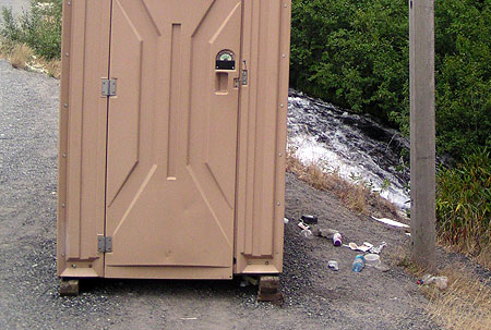
Camp Creek takes the brunt of trash and pollution from US 26. This scene is the unimproved roadside trailhead at Mirror Lake, where a chemical toilet (and associated trash) sits precariously above a steep bank dropping directly into the stream

Camp Creek takes the brunt of trash and pollution from US 26. This scene is the unimproved roadside trailhead at Mirror Lake, where a chemical toilet (and associated trash) sits precariously above a steep bank dropping directly into the stream

Just a few hundred yards downstream from the scene in the previous photo, Camp Creek spills over beautiful Yocum Falls, a seldom-visited spot bypassed by the modern highway. The pool below the falls is sullied with plastic cups, sport drink bottles and tires that have found their way into the stream from the highway

Just a few hundred yards downstream from the scene in the previous photo, Camp Creek spills over beautiful Yocum Falls, a seldom-visited spot bypassed by the modern highway. The pool below the falls is sullied with plastic cups, sport drink bottles and tires that have found their way into the stream from the highway

The traditional “building your way out” mindset has been bad for business in the local communities along the highway. The wider, noisier road has made it even less attractive for day tourists to risk a stop at the remaining shops and restaurants in the corridor. Worse, the huge 5-lane cross sections built on Highway 26 over the last decade have effectively cut the mountain villages in half by creating a scary barrier for local traffic to navigate, whether on foot, bicycle or in a vehicle.

Widening the Loop Highway is even worse for the natural environment, as highway trash, polluted runoff and blown gravel enters directly into the Salmon River, Still Creek, Camp Creek (pictured above) and the Zigzag River. All four streams serve as important salmon and steelhead habitat, a fact lost on the rush to make room for a few weekends of ski traffic each year.

A New Direction?

The Mount Hood Skiway was an early 1950s experiment to lessen parking pressure on Timberline Lodge - it failed, but may have been ahead of its time!

The Mount Hood Skiway was an early 1950s experiment to lessen parking pressure on Timberline Lodge – it failed, but may have been ahead of its time!

ODOT’s new MHMTP is both comprehensive and innovative. The plan is guided by the following objectives for how future travel should occur on the mountain:

• Improved highway safety for all users
• Expanded travel options year-round
• Reduced peak travel demand
• Enhanced mobility and access to recreation and local communities
• New projects should be financially feasible and sustainable
• New projects should be achievable in the next 15 years

The new focus on cost-effectiveness and a broader definition of desired outcomes beyond simply chasing traffic is new for ODOT — and for Mount Hood. It follows the lead of urban areas across the country, where cities are increasingly moving away from big-ticket road projects that seldom provide the advertised safety or mobility benefits used to justify them, and toward more practical solutions that have fewer unintended consequences.

A decade of futile "widening for safety" projects in the Highway 26 corridor has mostly resulted in dividing local communities and increasing highway runoff, with little traffic benefit

A decade of futile “widening for safety” projects in the Highway 26 corridor has mostly resulted in dividing local communities and increasing highway runoff, with little traffic benefit

To achieve these core objectives in managing the Mount Hood travel corridor, the MHMTP lays out four areas of proposed action – this is the real substance of the plan:

1. Better managing the system: in this area, the plan calls for another plan known as a “concept of operations”, which is transportation jargon for an operations blueprint for the Mount Hood loop from the City of Sandy to Hood River. Elements of an operations blueprint could range from web-based traveler information to new or upgraded electronic message signs along the highway, with real-time updates on traffic, parking, transit and emergencies.

The goal of this element of the MHMTP is to make the best use of the system through better-informed travelers and to better coordinate the various public agencies (ODOT, the Forest Service and the two counties) involved in operating the road system.

How it could be better: the details of the “concept for operations” aren’t nailed down at this point (thus the need for another plan), but one strategy not mentioned in the list of possibilities is variable speed limits along the entire loop. This key recommendation from ODOT’s 2010 Highway 26 Safety Audit deserves to be a priority above other, more costly highway projects already moving forward in the area. DOTs around the country are using this technology with excellent results in improving safety and traffic efficiency, and ODOT should join the movement.

An even larger gap in the strategy is an unwillingness by ODOT and the Forest Service to require the ski resorts to adopt peak pricing as a means to help spread out demand. The resorts are loathe to do this, given their troubled future (as described in Part 1 of this article), but if all three major resorts adopt the same policy, they will at least retain their current competitive positions with one another, while Mount Hood’s communities and environment would benefit from a coordinated effort to spread out the highway demand.

Not in the plan: pricing incentives for parking and lift tickets at the big three resorts to spread demand from weekend peaks

Not in the plan: pricing incentives for parking and lift tickets at the big three resorts to spread demand from weekend peaks

Sadly, it will be a very long time before the Forest Service asks the resort to adopt more aggressive peak pricing for lift tickets, but that is the best long-term solution available for spreading out ski demand. Short of that, ODOT holds the cards for managing parking, as all parking along the mountain portion of the Mount Hood Loop Highway falls within a state-designated SnoPark permit area.

Currently, ODOT charges a generic fee for annual and day passes to park at the SnoPark lots (including all three ski resorts), but the agency should consider using these permits to better manage demand on the highway. This is a very low-cost strategy to avoid some very high-cost road widening projects.

2. Bicycle and pedestrian projects: this much-needed element of the plan calls for improved bike and pedestrian crossings at key locations along the loop highway. Highway widening is also called for to allow for more shoulder space for bicycles, along with bike safety improvements at key intersections and traveler information for bicycles. While not driven by ski resorts, this element of the plan embraces the potential for Mount Hood to become a more balanced, year-round recreation destination, and the Loop Highway becoming less of a barrier to hikers and cyclists.

Notably, the famously crowded Mirror Lake trailhead is called out for relocation to address safety issues with the current trailhead. The new trailhead could be sited across the highway, accessed from an existing section of the Historic Mount Hood Loop Highway (that now serves the Glacier View SnoPark), and connected to the current trailhead with a new pedestrian bridge over US 26.

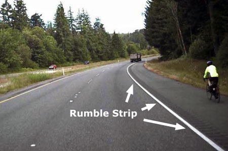
Rumble strips are very effective at keeping distracted drivers out of bike lanes, but bikes also need enough lane space to keep away from the rumble strip

Rumble strips are very effective at keeping distracted drivers out of bike lanes, but bikes also need enough lane space to keep away from the rumble strip

How it could be better: “widening” for bicycle lanes is a default recommendation that you might expect from ODOT, but the lanes along the Mount Hood loop are already very wide in many spots, so keep your fingers crossed that our highway planners are judicious about where to actually widen the road. In most cases, simply providing rumble strips along the shoulder stripe would go a long way to keep cycles safe from motor vehicle traffic, and require fewer subalpine trees to be cut for road widening.

A major gap in this element of the MHMTP is lack of policy direction on speeding or travel speeds — two of the three main contributors to serious accidents identified in the 2010 ODOT safety study (with winter conditions as the third).

Extending and enforcing the existing ODOT safety corridor and 45 mph speed limit from Rhododendron to the Hood River Meadows entrance to Mount Hood Meadows would make cycling along this most mountainous portion of the loop highway much safer – which in turn, makes cycling more attractive, especially on the lower sections of the loop that are generally snow free year-round.

"Widening for bicycle lanes" sounds easy, but the devil is in the details when the road travels through public forest lands

“Widening for bicycle lanes” sounds easy, but the devil is in the details when the road travels through public forest lands

3. Improved transit service: The MHMTP plan calls for new transit from Sandy to the mountain, and Clackamas County recently received a US Department of Transportation grant to expand its Mount Hood Express bus service from Sandy to Ski Bowl, Government Camp and Timberline Lodge. Rides are $2 each direction, with ten buses daily during the ski season, seven in the off-season. The trip from Sandy to Government Camp takes about 55 minutes and Timberline Lodge at about 75 minutes, so quite competitive with driving times and much less expensive.

It’s a good start, and long overdue. The fact that almost all traffic heading to the mountain during the winter season is destined for Government Camp, Timberline or Meadows makes the Mount Hood area highly serviceable with transit, provided a long-term funding mechanism can be found.

For too long, a very limited supply of shuttles and private ski buses at the Mount Hood resorts have been the sole transit option along the loop highway

For too long, a very limited supply of shuttles and private ski buses at the Mount Hood resorts have been the sole transit option along the loop highway

How it could be better: The proposed transit service in the MHMTP is great if you’re coming from Sandy — or able to drive and park your car there — but it doesn’t allow for truly car-free trips to the mountain in a region that is increasingly interested in having this option.

For years, people have wondered aloud about “extending MAX to the mountain”, but that will never happen — the cost would be astronomical and the ridership on the best of days wouldn’t come close to justifying the cost. But bus transit is completely within reach, and well-suited to the demand.

A proposal called “The Boot Loop” on this blog showed how it could be done — save for public and private interests along the loop highway coming together to make it happen. Let’s hope the Mountain Express pilot project is just the beginning of a more comprehensive transit system on Mount Hood and in the Gorge.

4. Safety projects: several critiques of ODOT’s ill-conceived “widening for safety” campaign along the Mount Hood loop have appeared in this blog over the past few years, and thankfully, some of the worst elements of the most recent phase between Rhododendron and Government Camp have been dropped.

Most recently, ODOT failed to receive construction bids within its project budget for this latest phase, and that is potentially good news if it means that some of the remaining bloated, environmentally destructive elements of the project (like cutting back cliffs on Laurel Hill) are scaled back.

Given this context, the safety projects contained in the MHMTP plan are refreshingly sensible and practice — truly “safety” projects, and not just an old-school highway widening agenda wrapped in an attractuve safety package.

ODOT owes the rural communities (like Rhododendron, above) along the loop highway retrofits to undo the damage from the "widening for safety"

ODOT owes the rural communities (like Rhododendron, above) along the loop highway retrofits to undo the damage from the “widening for safety”

How it could be better: travel speed is the single most important lever for highway engineers to reach for if improved safety is truly the desired outcome. ODOT was bold and forward-thinking when it adopted a safety corridor along a portion of Highway 26 several years ago, and especially when the agency adopted a 45 mph speed limit from Wildwood to Rhododendron.

There’s no reason why this successful strategy can’t be extended for the remainder of the ski commute along the Loop Highway, to the lower entrance at Mount Hood Meadows. As the 2010 ODOT safety audit clearly showed, nearly ALL of the serious accidents in this corridor were directly tied to heavy winter travel, and especially weekends, when the predictable crush of day skiers descends upon the mountain.

What’s Next?

ODOT will be wrapping up the MHMTP shortly. You can track the final recommendations on their project website:

Mount Hood Multimodal Transportation Plan website

As the MHMTP moves forward toward funding, the focus will shift to Clackamas and Hood River counties, the Forest Service, ODOT and the ski resorts working collaboratively to bring the various strategies completion. The plan sets forth three tiers of project, but all recommendations fall within a (relatively) short window of 15 years.

The Mirror Lake trailhead could see big changes under the proposed MHMTP plan

The Mirror Lake trailhead could see big changes under the proposed MHMTP plan

ODOT has an institutional habit of saying it “owns” the highways, but in fact, the public owns it – that’s us! Thus, it falls upon the true owners of the Loop Highway to track the details — the specific projects that will carry out the new direction called for in the MHMTP. Perhaps more importantly, it falls upon us to speak out against more funding of old-school road widening projects cloaked as “safety improvements” that could effectively cancel out the MHMTP proposals.

Over the next few years, the recommendations in the MHMTP will gradually be funded through ODOT’s statewide transportation improvement program and similar capital funding programs at the local level. Watch this blog for more details on how the dollars actually roll out in coming years on our beloved loop highway!

Restoring the Sahalie Falls Bridge

East Fork Bridge at Sahalie Falls as it appears from the modern Loop Highway

East Fork Bridge at Sahalie Falls as it appears from the modern Loop Highway

After years of delay and public agency wrangling, the long-awaited restoration of the East Fork Bridge at Sahalie Falls (henceforth simply called the “Sahalie Falls Bridge” in this article) began this summer. The project is advancing under a division of the Federal Highway Administration (FHWA) responsible for roads on public lands, and is scheduled for completion this year.

The Sahalie Falls Bridge was constructed as part of the final leg of the Mount Hood Loop Highway in the late 1920s. The bridge was completed in 1928, and is the most dramatic nod to the Samuel Lancaster’s Columbia River Highway on the Mount Hood portion of the loop highway.

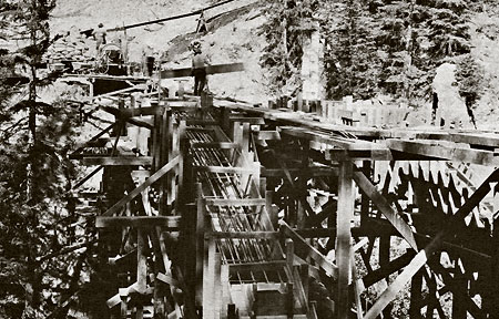
Construction of the East Fork Bridge in 1928 (USFS)

Construction of the East Fork Bridge in 1928 (USFS)

The structure was designed by federal lands bridge engineer H.R. Angwin as a graceful arch, spanning the East Fork directly in front of Sahalie Falls, with decorative railings and sidewalks built to allow travelers to stop and take in the inspiring views.

Complementing the idyllic setting is a cobblestone-faced drinking fountain, installed at the east end of the bridge. The fountain once provided a continuous supply of ice-cold mountain water to visitors, and was one of three original stone fountains placed along the Mount Hood portion of the old loop highway.

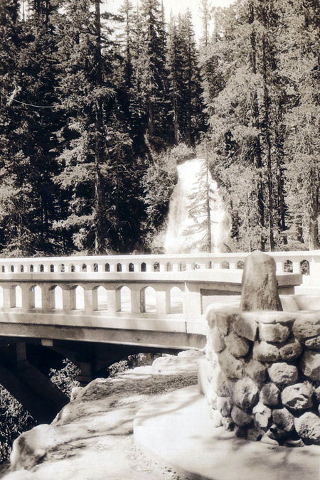
Sparkling new Sahalie Falls bridge and fountain in the early 1930s

Sparkling new Sahalie Falls bridge and fountain in the early 1930s

The bridge carried loop highway traffic well into the 1950s, until the modern-day Highway 35 was built, bypassing this section of the old road. The new “straightened” highway not only deprived travelers of seeing Sahalie Falls, it also skipped the mountain views across beautiful Hood River Meadows, just east of the falls on the old road.

Today, this bypassed section of the old highway remains open to the public (when snow-free) and will be drivable again once the bridge restoration is complete.

Who was H.R. Angwin?

One of the mysteries of the old bridge at Sahalie Falls is the life of the designer and builder, Henry Raymond (H.R.) Angwin. Public records show him to be the Senior Bridge Engineer in the San Francisco office for the U.S. Bureau of Public Roads from the 1930s through the 1950s. Over the span of his career, Angwin designed dozens of bridges in the western states.

Oakland Tribune Sunday, September 30, 1917

BETROTHALS HOME WEDDING

In a picturesque setting of pink, Miss Neville Stevenson became the bride last night of Henry Raymond Angwin. Eighty relatives [witnessed the] ceremony read by Dr. John Stevenson and William Angwin.

The bride wore a smart frock of white and silver with a conventional tulle veil and orange blossoms, and carried a shower bouquet of lilies of the valley. Her attendant, Miss [Mabel] Gustaffson, blonde as the bride is dark, was in pretty contrast to pink satin and tulle. The bride’s gown was taupe broadcloth with a chic taupe hat white fox furs accenting the tulle.

Mr. and Mrs. Angwin [will] leave for an extended trip through the east, visiting the interesting cities en route. The bride is the daughter of Mr. and Mrs. A. V. Stevenson, whose home on Newton Street was the scene of the pretty service. Returning to Oakland, the young people will take an apartment in the Piedmont.

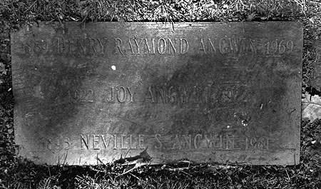
H.R. Angwin was born in 1889, graduated from Oakland High School in California in January 1907, and married Neville Stevenson ten years later, in 1917. They had been married 52 years when H.R. Angwin died in 1969. Neville Angwin died twelve years later, in 1981.

The Angwins had at least two children, Joy and Robert. Joy died as an infant, and is buried at Mountain View Cemetery in Oakland with her parents.

Mountain View Cemetery in Oakland, resting place of the Angwins (Wikimedia)

Mountain View Cemetery in Oakland, resting place of the Angwins (Wikimedia)

Cemetery marker for Henry, Neville and Joy Angwin (BillionGraves.com)

Cemetery marker for Henry, Neville and Joy Angwin (BillionGraves.com)

H.R. Angwin designed and built a number of familiar Oregon bridges during his tenure as a federal bridge engineer. The East Fork Bridge at Sahalie Falls was one of his first, completed in 1928. Two years later, Angwin designed and built the larger, and equally graceful Salmon River Bridge in Lincoln County. This hard-working gem also survives today, carrying heavy traffic on Highway 18 to the Oregon Coast.

H.R. Angwin's Salmon River Bridge in Lincoln County

H.R. Angwin’s Salmon River Bridge in Lincoln County

Several other Angwin bridges are scattered across Oregon, but most notable in the Mount Hood area are the steel truss bridges built along the Clackamas River Highway in the 1950s: Carter Bridge, Armstrong Bridge, Whitewater Bridge and Cripple Creek bridge all continue to carry traffic today.

(Author’s note: sadly, not much has been written about H.R. Angwin’s long career as a federal bridge builder, so this part of the article is included in hopes of improving awareness of his contributions, and perhaps inspiring further accounts of life)

The 2013 Restoration Project

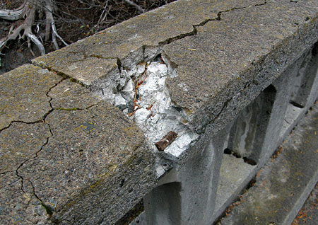
Frost damage to the railings on the Sahalie Falls Bridge in 2009

Frost damage to the railings on the Sahalie Falls Bridge in 2009

The Sahalie Falls Bridge had begun to show signs of serious deterioration by the late 1990s, and by the mid-2000s, whole chunks of the north railing were breaking loose — sadly, helped along by vandals pulling at the exposed rebar.

Railing Damage on the East Fork Bridge in 2009

Railing Damage on the East Fork Bridge in 2009

By 2008, the Oregon Department of Transportation (ODOT) had blocked vehicle access to the bridge, and a project was proposed in the state highway budget to restore the bridge. The original ODOT restoration project later evolved to become a FHWA project by 2011.

The restoration focuses on three areas of needed repair: (1) rebuilding the approach abutments on both ends of the bridge, (2) replacing the heavily damaged north railing cap and (3) restoring the footing on the historic fountain at the east end of the bridge (there may be other repairs planned, but there is little information available for this project, so this list covers the repairs underway as of October of this year).

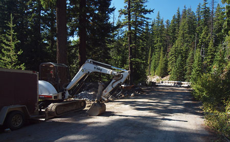
Construction at the old bridge was finally in full swing in September 2013

Construction at the old bridge was finally in full swing in September 2013

Restoring the bridge abutments involves pouring new reinforced concrete footings at each end of the bridge span and improving surface drainage at the west end to direct storm runoff away from the bridge. The gravel pullouts at both ends of the bridge also appear due for grading and resurfacing as part of the project, as they currently serve as construction staging areas.

The following images show the recent drainage work at the west end, along the approach to the west bridge abutment (as of mid-October), including a recently installed culvert (under the wet fill in the first photo) to address the drainage issues apparent in the earlier 2009 photo (second photo):

Major drainage work is underway as part of reconstructing the west bridge abutment

Major drainage work is underway as part of reconstructing the west bridge abutment

Repeated repairs to the abutment and debris washed onto the roadway is apparent in this 2009 view of the west approach to the bridge

Repeated repairs to the abutment and debris washed onto the roadway is apparent in this 2009 view of the west approach to the bridge

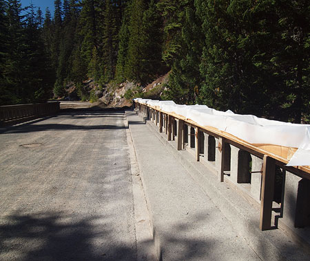
Repairs to the north railing cap extend for the full length of the bridge, with the new cap seated on original concrete railings. As of mid-October, the forms for the new cap had been constructed and were ready to be poured, presumably with concrete, topped by sand mortar. The next series of images show more detail of the railing cap replacement:

Forms in place for pouring a new cap along the north railing

Forms in place for pouring a new cap along the north railing

The forms for the new caps are secured from below with screw clamps

The forms for the new caps are secured from below with screw clamps

Close-up view of the wood forms constructed for the new railing cap

Close-up view of the wood forms constructed for the new railing cap

A peek inside the railing caps (below) shows careful attention to original design details, including quarter-round trim along the outer edges. New reinforcing rods are wired to the original rebar posts embedded in the rails.

When the new caps are poured, masons will use a screed (board) cut with a low arch to repeat the slightly curved top seen in the original cap. The plastic sheeting attached to the forms will be secured over the newly poured caps to slow the curing process to ensure a strong set.

A peek into the railing cap forms shows careful attention to original design details

A peek into the railing cap forms shows careful attention to original design details

In a nearby pile of demolition rubble, chunks of the old railing cap show the quarter round detail that follows the outer edge of the caps

In a nearby pile of demolition rubble, chunks of the old railing cap show the quarter round detail that follows the outer edge of the caps

The south railing is not part of the restoration project, apparently because of its relatively sound condition

The south railing is not part of the restoration project, apparently because of its relatively sound condition

The third element of the Sahalie Falls Bridge project is replacement of a portion of the concrete footing that supports the historic cobble-faced fountain. In the 2009 photo (below) you can see where a section of the fountain base facing the East Fork (behind the fountain) had sunk toward the creek over time, threatening the stability of the fountain.

The sunken east abutment and partially sunken footing on the old fountain can be seen in this 2009 view

The sunken east abutment and partially sunken footing on the old fountain can be seen in this 2009 view

The bowl and rim of the old fountain were restored at some point in the more recent past, and are not part of the current project. The fountain is one of three that survive along the loop highway. The fountain at Buzzard Point still functions, while the fountains at Sahalie Falls and Sherwood Campground (below) are no longer operational and simply serve as rain basins.

The bowl and rim of the fountain were restored at some point in the more recent past

The bowl and rim of the fountain were restored at some point in the more recent past

The three historic Mount Hood Loop fountains, compared

The three historic Mount Hood Loop fountains, compared

[Click here for a larger comparison photo]

This view shows the new concrete footing in place on downslope side of the old fountain

This view shows the new concrete footing in place on downslope side of the old fountain

Crews saved this piece of the old fountain footing -- perhaps to be repurposed as a bench?

Crews saved this piece of the old fountain footing — perhaps to be repurposed as a bench?

Once the restoration project is complete, the Sahalie Falls section of the old loop will re-open to traffic. For the past decade or so, the route has been signed as one-way at the west end, where it connects to the Bennett Pass interchange, so the best way to explore the old highway is follow the signs to Hood River Meadows, then turn left onto the old road before reaching the Meadows resort parking.

Celebrating the Historic Sahalie Falls Bridge

Now that the restoration work is finally underway, the stage is set for some much-needed visitor improvements to the Sahalie Falls area. The view of the falls from the historic bridge is missed by too many travelers, and the odd near-miss with the Umbrella Falls trail (just 100 yards from the bridge, but with no trail connection) has resulted in some messy boot paths formed by hikers attempting to see Sahalie Falls.

This proposal would address both issues, and make it easier to visit the old bridge and falls, whether as a spur from nearby hiking trails, or simply by pulling off Highway 35.

Sahalie Falls trail proposals

Sahalie Falls trail proposals

[Click here for a large map]

The first part of the proposal is a short hiking spur from the bridge to the nearby Umbrella Falls Trail. This would be a very simple trail to build, and could easily be constructed by volunteers. It would not only provide a safe way for hikers to view the falls, but would also allow for the various boot paths along this slope to be decommissioned, and some of the trampled vegetation to be restored.

The pullout on Highway 35 at Sahalie Falls is wide enough to easily allow for roadside parking and a new trailhead

The pullout on Highway 35 at Sahalie Falls is wide enough to easily allow for roadside parking and a new trailhead

The second part of the proposal is an accessible loop trail that would allow the elderly, disabled and families with small children to experience the East Fork in a new way.

The trailhead for the new loop would be at the east end of an existing pullout on Highway 35, where the historic highway bridge can be seen from the modern loop road. The first leg of the new loop trail would follow the East Fork to the base of little-known Lower Sahalie Falls, a charming waterfall hidden in the canyon beneath the historic bridge.

Lower Sahalie Falls

Lower Sahalie Falls

From here, the new accessible loop trail would cross the East Fork in front of the lower falls and gently traverse up the west slope of the canyon to the west bridge approach. Once at the old highway grade, the new path would cross the historic bridge, providing a view back to the trailhead pullout on Highway 35.

View down the East Fork to Highway 35 from the historic Sahalie Falls Bridge

View down the East Fork to Highway 35 from the historic Sahalie Falls Bridge

Visitors to the bridge inevitably cross to admire the views from both sides, so an accessible route would probably warrant a marked crossing at the two bridgeheads, where people using mobility devices could most safely access the sidewalks.

After enjoying the views from the bridge, visitors would continue past the east end to a resumption of the new loop trail, following the east leg back to the trailhead. The total distance of the accessible loop would be about 0.3 miles with a very modest elevation gain of about 60 feet.

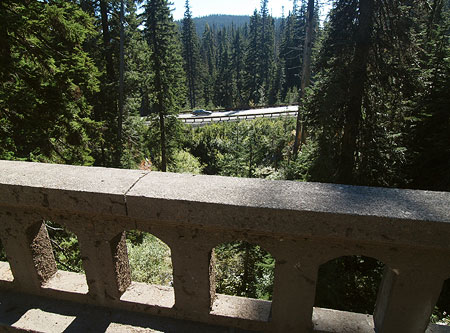
View of Sahalie Falls from the historic loop highway bridge

View of Sahalie Falls from the historic loop highway bridge

Accessible trails are often paved, but for this new route, a better option would be fine gravel, mostly because it would provide better traction in an often wet environment. But the proposed loop is also within the deposit zone for winter highway snow removal that sends a lot of grit used to sand icy roads far into the adjacent forest. A gravel trail surface could actually be enhanced by these annual deposits, where a paved surface would require sweeping to remove winter gravel.

What Would it Take?

As with all proposals in this blog, the Sahalie Falls accessible trail concept relies on the U.S. Forest Service — and in this case, Oregon Department of Transportation — acknowledging the need for more recreational and interpretive opportunities in the Gorge and on Mount Hood.

While the proposed spur connection to the Umbrella Falls trail could be built by volunteers, the proposed accessible loop trail would be a major endeavor that could only be accomplished by the Forest Service in conjunction with ODOT.

The original USGS survey marker at the east end of the bridge has been uncovered from years of debris

The original USGS survey marker at the east end of the bridge has been uncovered from years of debris

The added twist in this proposal is the need for an accessible trail, something in very short supply in our region despite a rapidly growing elderly and disabled population. Oregon State Parks and Recreation has made great strides in responding to this need in recent years, but the Forest Service lags behind badly, with few accessible facilities built in the last 30 years.

Fortunately, a new guide for designing accessible trails has recently been developed by the Access Recreation project, an ad-hoc organization formed to develop better design guidelines for public agencies involved in trail-building.

SahalieFallsBridge28

The guidelines are now available on the Access Oregon website, and cover everything from trail surface and slope recommendations to best practices for signage and trailside amenities that address the needs of elderly and disabled trail users. It’s a great resource for trail advocates and public agencies, alike — and could help shape new trail options on Mount Hood!

The Newton Clark Moraine

Mount Hood and the Newton Clark Moraine from Bennett Pass Road

Tucked on the remote east shoulder of Mount Hood is the Newton Clark Moraine, the largest glacial formation on the mountain, and one of its most prominent features. Yet this huge, snaking ridge remains one of Mount Hood’s least known and most mysterious landmarks.

At over three miles in length, and rising as much as a thousand feet above the glacial torrents that flow along both flanks, the Newton Clark Moraine easily dwarfs the more famous moraines along the nearby Eliot Glacier.

East Face Detail with Newton Clark Moraine

How big is it? The Newton Clark Moraine contains roughly 600 million cubic yards of debris, ranging from fine gravels and glacial till to house-sized boulders. This translates to 950 million tons of material, which in human terms, means it would take 73 million dump truck loads to haul it away.

Backcountry skiers often call the moraine “Pea Gravel Ridge”, which is a poor choice of words, as pea gravel is something you would expect in tumbled river rock. The Newton Clark Moraine is just the opposite: a jumble of relatively young volcanic debris, some of it located where it fell in Mount Hood’s eruptive past, some of it moved here by the colossal advance of the Newton Clark Glacier during the last ice age.

Newton Clark Moraine

As a result, the rocks making up the moraine are sharp and raw, not rounded, and the debris is largely unsorted. Giant boulders perch precariously atop loose rubble, making the moraine one of the most unstable places on the mountain.

In recent years, erosion on Mount Hood has been accelerating with climate change. Sections of the Newton Clark Moraine are regularly collapsing into Newton and Clark creeks, creating massive debris flows that have repeatedly washed out Highway 35, below.

2006 Newton Creek Washout on Highway 35 (USFS)

Today, an ambitious Federal Highway Administration project is underway to rebuild and — supposedly — prevent future washouts on Highway 35 at Newton Creek and the White River. But given those 73 million dump truck loads of debris located upstream on Newton Creek, it’s likely that nature has different plans for the area as climate change continues to destabilize the landscape.

Something a Little Different

Most glacial moraines on Mount Hood are lateral moraines, formed along the flanks of glaciers, or terminal moraines formed at the end of a glacier. The Newton Clark Moraine is different: it is a medial moraine, meaning that it formed between two rivers of ice.

(Wikipedia)

As shown in this schematic (above), medial moraines are more common in places like Alaska or Chile, where much larger glaciers flow for miles, like rivers. When these glaciers merge, a medial moraine is often created, marked by the characteristic stripe of rock that traces the border between the combined streams of ice.

At the surface of a glacier, only the top of a medial moraine is visible. Only upon a glacier retreating can the full size of a medial moraine be appreciated. In this way, the height of the Newton Clark Moraine is a reasonable estimate of the height (or depth) of the ancestral Newton Clark Glacier during the most recent ice age advance — the crest of the moraine approximates the depth of the former glacier.

The Newton Clark Prow

The Newton Clark Moraine is even more unique in that the two bodies of ice that formed the moraine flowed from the same glacier. Like the modern Newton Clark Glacier, the much larger ice age ancestor also began as a single, wide body of ice on Mount Hood’s east flank, but then split as it flowed around the massive rocky prow that now marks the terminus to the glacier.

The outcrop is typical of the stratovolcanoes that make up the high peaks of the Cascades. Stratovolcanoes are formed like a layer cake, with alternating flows of tough, erosion-resistant magma and loose ash and debris deposits. The Newton Clark Prow is a hard layer of magma in the “cake” that is Mount Hood, with looser layers of volcanic ash and debris piled above and below.

Newton Clark Prow detail from Gnarl Ridge

In fact, without this broad rib of volcanic rock to shore up its eastern side, the very summit of Mount Hood might well have been further eroded during the series of glacial advances that have excavated the peak.

Similar rocky outcrops appear elsewhere on the mountain, forming Mississippi Head, Yocum Ridge, Barrett Spur and the Langille Crags. Hikers visiting Gnarl Ridge know the Newton Clark Prow from the many waterfalls formed by glacial runoff cascading over its cliffs.

(Click here for a larger version)

The much softer and less consolidated rock below the prow made it easy for the ice age ancestor of the Newton Clark to scour away the mountain. This action created the huge alpine canyons that Clark and Newton creeks flow through today, as well as the enormous U-shaped valley of the East Fork Hood River.

A Glimpse into the Ice Age

While today’s Newton Clark Glacier flows a little over a mile down the east face of the mountain, its giant ice age ancestor once flowed more than 12 miles down the East Fork valley (today’s Highway 35 route), nearly to the junction of today’s Cooper Spur road. At its peak, the ancestral glacier was more than 1,200 feet deep as it flowed down the valley.

If you were to walk along the crest of the Newton Clark Moraine at that time (as suggested in the illustration, below), you would have likely been able to walk directly across the ice to Gnarl Ridge or today’s Meadows lifts, as the Clark and Newton Creek valleys were filled to the rim with rivers of ice.

Ancestral Newton Clark Glacier Extent

(Click here for a larger version)

This most recent ice age is known to scientists as the Fraser Glaciation, and extended from about 30,000 years ago until about 10,000 years ago. At its peak, the zone of perpetual snow was as low as 3,400 feet, though probably closer to 4,000 feet in the area east of Mount Hood.

This means the deflation zone — the point in its path when a glacier is melting ice more quickly than snowfall can replace — was probably somewhere near the modern-day Clark Creek Sno-Park, or possibly as low as the Gumjuwac Trailhead, where today’s Highway 35 crosses the East Fork.

Below this point, the ancestral glacier would have changed character, from a white jumble of cascading ice to one covered in rocky debris, yet still flowing toward its terminus at roughly at modern-day confluence of the East Fork with Polallie Creek (the map below shows a very generalized estimate of the ancestral glacier)

Geologists believe the Fraser-era glacial advances followed the path of earlier glaciers in their flow patterns. With the Newton-Clark glacier, scientists have found traces of at least two previous glacial advances from even more ancient glacial periods that extended far down the East Fork Valley prior to the Fraser Glaciation. This helps explain the magnitude of the glacial features in the East Fork valley, having been repeatedly carved into an enormous U-shaped trough by rivers of ice over the millennia.

Ancestral Newton Clark Glacier extending down the East Fork valley

(Click here for a larger version)

The timing of the Fraser Glaciation is even more fascinating, as it coincides with the arrival of the first humans in the Americas. It was during this time — at least 15,000 years ago, and likely much earlier — that the first nomadic people crossed the Bering Straight and moved down the Pacific Coast.

Does this mean that the earliest humans in the region might have camped at the base of Mount Hood’s enormous ice age glaciers, perhaps hunting for summer game along the outflow streams? No evidence exists to show just how far humans pushed into Mount Hood’s prehistoric valleys, but scientists now believe people have lived along the Columbia River for at least 10,000 years, and the oral histories of some tribes in the region are also believed to extend back to that time.

How to See It

The best way to see and appreciate the Newton Clark Moraine is along the Timberline Trail where it follows Gnarl Ridge. This route offers a wide-open view across Newton Canyon to the moraine. You can also see the active geology at the headwaters of Newton Creek, where the slopes of the moraine continue to change every winter. On a breezy day, you might also notice sulfur fumes blowing over the summit from the crater — a reminder that Mount Hood is still very much a living volcano today.

Mount Hood and the Newton Clark Moraine (on the left) from Gnarl Ridge

You can follow a detailed hike description to Gnarl Ridge from the Portland Hikers Field Guide at the following link:

Portland Hikers Field Guide: Gnarl Ridge Hike

Another way to see the moraine is from rustic Bennett Pass Road. In summer, you can walk or bike along the old road from Bennett Pass, and there are several viewpoints across the East Fork valley to the headwaters and the Newton Clark Moraine. In winter, you can park as the Bennett Pass Sno-Park and ski or snowshoe to one of the viewpoints — a popular and scenic option.

The most adventurous way to visit is to simply hike the crest of the moraine, itself. This trip is only for the most fit and experienced hikers, as the final segment is off-trail, climbing high above the Timberline Trail. The reward is not only close-up look at the mountain from atop the moraine, but also a rare look at a series of spectacular waterfalls that can only be seen from this vantage point.

Whatever option you choose, you’ll have unique glimpse into Mount Hood’s past — and possibly its future — through one of the mountain’s most unusual geologic features.

Highway 26 Widening Postscript… and Requiem?

Original Loop Highway section on Laurel Hill in the 1920s, later destroyed when the present highway was built in the 1960s

As a postscript to the previous two-part article, I offer some final thoughts on the proposed widening of the Mount Hood Highway in the Laurel Hill area:

First, the Oregon Department of Transportation (ODOT) process used to gather public input on projects like those proposed for Laurel Hill is abysmal. Information on the web is cryptic, at best, and generally absent. Amazingly, there is no opportunity to comment online, nor information on how or where to comment. When I contacted project managers about making comments, I was given different comment deadlines, a full month apart. The ODOT website contains no information on comment deadlines.

ODOT posts a “users guide” to the State Transportation Improvement Program (STIP) process used for funding decisions, but this document manages to be more cryptic than the draft STIP document, itself, since it has been written for government workers and program insiders, not citizens. The process is also designed to buffer the Oregon Transportation Commission from public comment, with any input that does make it to the ODOT region offices collected and processed in a way that effectively buries public concerns under official recommendations by ODOT managers and obscure “citizen” commissions called ACTs. Since there is no ACT for the Mount Hood area, the comment opportunities for the Laurel Hill proposals fall into an even murkier void. In the end, this is a process that is staff-driven, and out of step with the ethic of citizen-centered transportation planning.

Second, the STIP selection process is a done deal by the time most citizens see it, since projects emerge from within the ODOT bureaucracy, not through an open solicitation of public ideas and needs, or even a long-range plan that maps out a pool of projects to draw from.

Thus, the projects in the Laurel Hill area will be very difficult to stop, since they surfaced in the past STIP cycle, and are now about to be funded in 2010 and 2011 as a “routine” final step. Since citizens are discouraged from participation in the selection phase of project funding, these projects will likely advance to a design and construction phase that makes them inevitable before any real public outreach or discourse can really occur. This was the case in the previous “widening for safety” projects in the Wildwood area, where the broader public outreach to citizens in the adjacent corridor began long after the project was conceived and funded. This left area residents with a Hobson’s choice between various widening options for “safety” as opposed to real choices for improving safety that could have been less costly and destructive.

Loop highway construction in the Brightwood area in the 1930s

Third, it is time for the Oregon Transportation Commission to pull the plug on the notion of “widening for safety”. This is a dubious loophole in the funding process the OTC sets forth for project selection, where safety benefits generally bring projects to the top of the list.

That’s a laudable goal, but it allows widening projects cloaked under the “safety” mantle to advance, unquestioned, and become the first to be funded. But as the Wildwood project details admitted, these projects are mostly about “matching the cross-section” of previously widened highway sections in the vicinity, not safety. So, this is nothing more than an highway capacity agenda, and it should be openly considered as such, not slipped under the radar of the OTC.

The stakes are much higher for the Laurel Hill “widening for safety” projects. While future generations may choose to tear up the asphalt and replant the forests that were cut away to make room for a wider highway in the Wildwood and Rhododendron sections, the Laurel Hill projects will require ODOT to blast away more of Laurel Hill’s rocky face. These changes are permanent and destructive, and it would take centuries for the area to recover, should our children or grandchildren conclude that we made a grave error in judgement in an our efforts to save skiers a few minutes driving time. The decision ought to be considered carefully in this light, not slipped through without public discussion.

Simpler days: the original loop highway corkscrewed up Laurel Hill, molding to the terrain as it climbed the steep slopes made infamous by Oregon pioneers

It is also true that ODOT has the means for a very open discussion about the projects proposed on Highway 26, and could give the OTC a true sense of public support for these proposals. For example, ODOT could simply post signs along the highway advertising the projects, and direct interested citizens to an online opportunity to comment. The agency could even use the giant electronic message sign in Rhododendron for this purpose, if meaningful public involvement were truly the objective.

I submit these critiques as one who works in the transportation planning realm daily, so it is both frustrating and discouraging to imagine what an ordinary citizen would have to overcome to be heard in this process. It is a fact that transportation planning is an arcane and difficult to understand realm, and for this reason, Federal Highway Administration (FHWA) regulators are looking for more meaningful public involvement in transportation decisions at the state and local levels. The ODOT processes fall far short of what the FHWA envisions, where ordinary citizens could easily access information about projects that affect them, and make meaningful comment to decision makers.

To meet its regulatory expectations from the federal government, and its obligation to Oregon citizens who fund the very existence of ODOT, it is time for the agency to engage the public in a more meaningful way, and allow each of us to weigh in on how our tax dollars will be spent. The looming decisions about the Mount Hood Highway would be a good starting point for this needed reform.
_________________________________________

Download a copy of the Mount Hood National Park Campaign (PDF) comments on the Highway 26 projects: click here

Download a slide presentation of the 2009 safety audit (PDF) of the Laurel Hill section of Highway 26: click here