
The Bucher barn and Nesmith Point (2008)
For camera buffs, the century-old Bucher family dairy barn at the foot of St. Peters Dome in the Columbia River Gorge has been like an old friend. The huge, stately old structure could not have been more picturesque, with its bleached planks and rusty tin roof standing in dramatic contrast to the towering basalt walls of the Gorge.
Thus, it was to the great dismay of many when the barn came down this fall, and now is in the process of being salvaged.

The Bucher barn was located in the old Dodson district, a fading rural village that experienced its heyday in the 1930s, when the original Columbia River Highway was the premier travel route through the Gorge.
Until its recent collapse, the barn had survived to become the most prominent structure in the Dodson district in recent years, familiar to speeding traffic on I-84 (and plainly visible in the air photo, above).

The Bucher barn in happier days (2006)
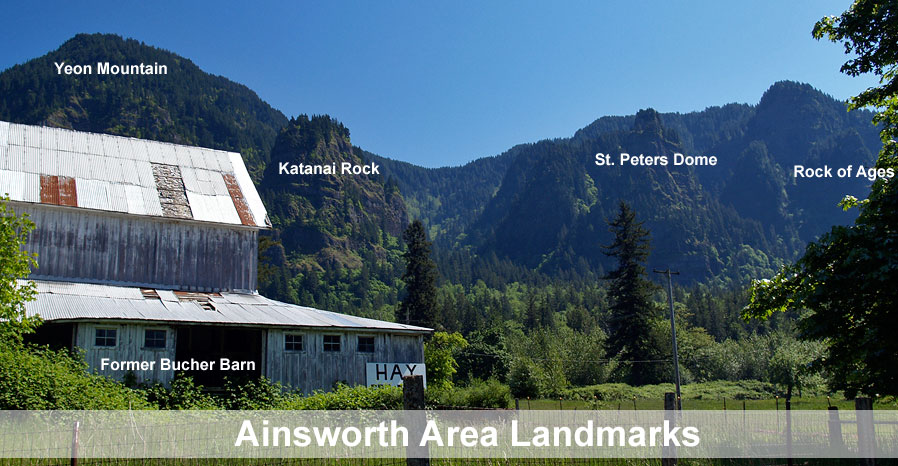
The Bucher barn was tucked at the base of the towering cliffs and spires of Ainsworth State Park, with Yeon Mountain, Katanai Rock, St. Peters Dome and Rock of Ages filling the skyline. Nesmith Point is also prominent, and is the loftiest cliff in the Columbia Gorge, rising nearly 4,000 feet directly above the river.
The barn was located in an area that made headlines in the winter of 1996, when a series of dramatic debris flows roared down from the Gorge rim and burst across I-84, closing the freeway for five days and destroying nearby homes — but sparing the barn. (click here for a full account of the debris flows)

Beginning of the end in November 2010
In recent years, the U.S. Forest Service and Oregon State Parks have been actively acquiring private land in proximity to the Bucher barn as part of implementing the long-term vision for the Columbia River Gorge National Scenic Area. According to the National Integrated Land System (NILS), these acquisitions may cover the Bucher barn parcel, which could explain the barn coming down, though I have not been able to verify this connection.
(Note: please see the postscript to this article for updated background on the ownership of the barn and decision to bring it down).

The fallen barn in November 2010
The current deconstruction of the Bucher barn was underway by mid-November of this year. The plank siding had been partially removed from the lower half of the structure by Thanksgiving, but the main building frame was still intact.
By late November, however, the building had been toppled, tipping forward toward the frontage road with the roof framing intact. Whether the collapse was intentional or from a structural failure is unclear, though the ongoing salvage operation suggests that it was dropped intentionally.

Almost gone in December 2010
A series of early winter storms gripped the Gorge in late November and early December of this year, but the salvage work continues, and by mid-December, half the roof frame of the Bucher barn has been removed, along with most of the metal roofing.
At the current rate of removal, the barn will likely be gone in a few weeks, taking a bit of Oregon history with it. Thankfully, it is one of the more photographed barns in the region, so will live on through images that captured its charm and unique setting.

Bucher barn salvage in December 2010
The sudden demise of the Bucher barn is a reminder that historic barns are fading away across the Oregon landscape, so hopefully others can be equally appreciated and documented while they are still standing.
If you are interested in seeing this rapidly disappearing bit of history, take the Ainsworth exit on I-84, then follow signs to the eastbound Frontage Road and John B. Yeon State Park. The barn is located one-quarter mile from the interchange, just beyond the first house. Please respect the private property signs, and stay outside the fenced pasture.
Postscript
In April 2011, Breanna Mohr, a member of the Bucher family, provided some additional family history on the Bucher barn. The building once belonged to her great-grandfather, Joseph Bucher, a dairy farmer in the Dodson area. When Joseph Bucher passed away, his farm was divided among his children, and the portion that included the barn was passed to his daughter. Breana Mohr goes on to say:
“Now to explain why it is being tern down. The barn has been falling down for many years now, and my aunt could not keep up with the work that it needed… So the family decided to tear it down. This has been a hard thing for my family because they all still remember it being full of milk cows, (my grandfather was the milk man in Dodson) and having to get up early in the morning to milk the cows.”
Breanna also pointed out that I didn’t include Katanai Rock in the original article. The name was new to me, but after a bit of research, I learned that this is the local name for the huge monolith immediately above the Bucher farm. I’ve taken a shot at identifying the various landmarks that make up the towering heights of Ainsworth State Park and the Dodson area, including Katanai Rock:

Click here for a large version of this photo
Though all but the Katanai name are official and found on USGS maps, interpreting the jumble of contours on the map as they related to real features on the ground turns out to be more difficult than I’d imagined. Thus, I’d appreciate any corrections to this schematic that local residents or area explorers have to offer.
Finally, I’d like to thank Breanna Mohr and the Bucher family for not only providing historical background on the area, but also for keeping this fine old structure standing for so long. While it shall be missed by all of us, it was enjoyed for decades for its picturesque charm, and lives on in our memories, as well!
