
The first hiking trails on Mount Hood were built in the late 1890s, radiating from the newly constructed Cloud Cap Inn on the mountain’s north side. The steep hike up the south Eliot Glacier moraine to Cooper Spur was perhaps the first trail, as it was part of the still-popular Cooper Spur route to the summit. The original climber’s trail is still used, though a much gentler route built in the 1960s now ascends the spur in a series of well-graded switchbacks.
The new, graded trail carries thousands of hikers to the top of Cooper Spur each summer. It is among the most spectacular alpine hikes in the country, with jaw-dropping views of the sheer north face of Mount Hood and a close-up look at the massive jumble of flowing ice that makes up the Eliot Glacier.

The snowfields in question on Cooper Spur are permanent enough to be mapped.
It’s hard to know exactly why the newer, graded trail was routed over a set of mostly permanent snowfields when it was built, but this design flaw continues to be a problem for this otherwise exceptional trail. The newer trail initially follows the climber’s route fairly closely, sticking to the rim of the Eliot Glacier where the snow melts early and reliably each summer.
But near the crest of Cooper Spur, the newer route suddenly crosses the face of the spur, traversing to the south shoulder and overlooking the Newton Clark Glacier. It is in this section where the route crosses a set of persistent snowfields that are nearly permanent in all but the driest years.

The snowfields clearly show up in this 1890s view of Mount Hood in late summer.
This flaw in the newer route is confusing and potentially dangerous to the many hikers who venture to the top of the spur each summer. At 8,514 feet, the summit of Cooper Spur is truly alpine, so one of the benefits of the modern trail is to provide a relatively manageable hike to the top of the spur for the average visitor, despite the high elevation.
But when the trail disappears into the snow in this final pitch, hikers often resort to climbing directly up the snowfield — a dangerous choice — or scrambling up the steep climber’s trail, with its loose rock and cinders creating a potentially dangerous option for many hikers.

The snowfields as viewed from Cloud Cap Inn in the late 1890s.
The design flaw in the newer route may also have environmental impacts: the climber’s trail isn’t really a “trail”, but rather, a braided confusion of boot paths made less stable and more extensive each year as the popularity of the Cooper Spur hike continues to grow.

Early 1900s maps don’t show the snowfields, but they do show the climber’s trail on Cooper Spur.
While the ecological impact might seem inconsequential at this elevation, where few plants can even survive, the physical scars left on the rocky slopes are real and warrant better management of recreation travel in the area.
The high tundra landscape on the slopes of Mount Hood represents one of the most unusual and sensitive in the region, and a stray boot print can last for years. The ever-increasing variations on the climber’s trail that form each summer can take years to recover, even if given the chance.

The USGS 7.5 minute maps of the 1960s were the first to map the snowfields as permanent features. This 1962 map pre-dates the modern Cooper Spur Trail.
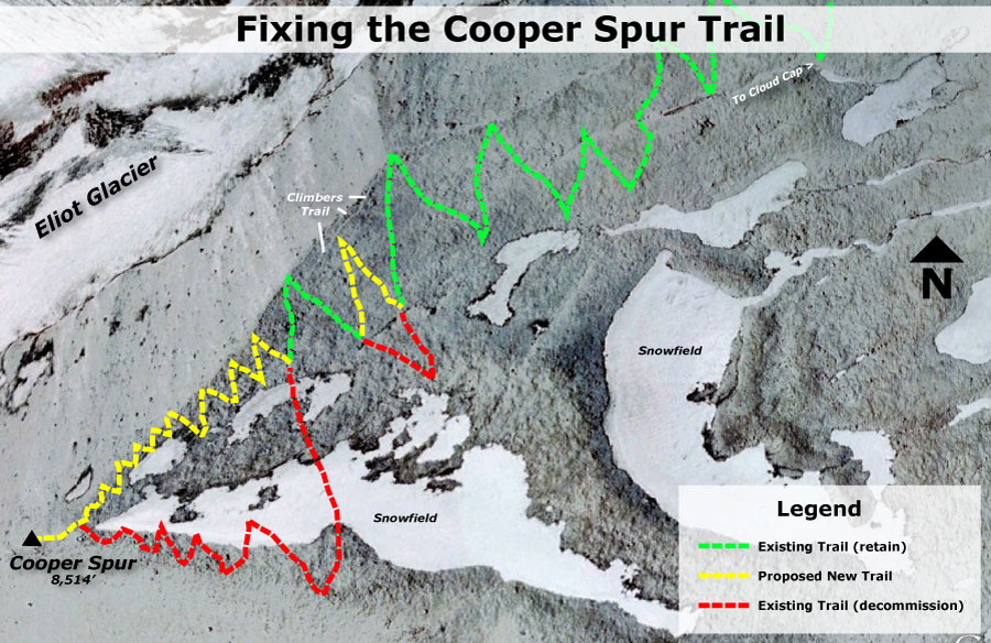
This article makes the case for addressing this problem in a couple of steps:
1. Realign the upper portion of the Cooper Spur Trail with a series of designed, graded switchbacks that roughly follow the climber’s trail, along the Eliot Glacier rim.
2. Decommission the problem sections that are usually snow-covered.
This proposal would not only corral the hiking hordes onto a more manageable, new path near the climber’s route, it would also leaves the bulk of the east slope of Cooper Spur untouched by hikers by decommissioning the old trail. This could greatly reduce the impact of the trail on the alpine ecosystem that exists on the slopes of Cooper Spur.

[Click here for a larger version of this map]
One of the most attractive aspects of this proposal is that it would be so easy to build. Building trails at this elevation, with the absence of soils and vegetation, is straightforward and very simple. The new route would simply need to be designed and surveyed, with construction done by volunteers or youth crews like the Northwest Youth Corps.

Looking up the climber’s trail to Cooper Spur and Mount Hood.
Trail construction would consists of rolling loose boulders and rocks to form a trail bench, and smoothing the surface of the new bench into a hiking tread with the abundant volcanic ash and glacial till that makes up most of the terrain at this elevation. This work is relatively easy, and surprisingly fast (I know this firsthand because I’ve adopted a couple of nearby trails in the area, and regularly rebuild worn trail segments in this high-elevation environment of rock and ice).
How to Help
If you’ve experienced the same frustration coping with the trail to Cooper Spur, your comments to the U.S. Forest Service can have an impact. This proposal represents a fairly simple effort, and there’s a good chance the Forest Service will respond if enough hikers weigh in on the hazards of the current trail alignment.
The best way to be heard is to go to the Mount Hood National Forest contact page and speak your mind — it’s easy, and you might just help get this trail fixed for generations to come!

Pingback: 2012 Mount Hood National Park Calendar « WyEast Blog