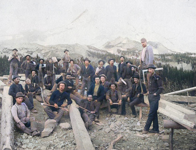
Workers cutting beams from solid pine trunks for the new Cloud Cap Inn during the summer of 1888. The (then) surging Eliot glacier loomed just beyond Cloud Cap in those early days (Author’s note: this is a modified historical image that I have colorized to bring the sense of the distant past a bit closer to our present-day world)
[click here for a large version]
When the builders of Cloud Cap Inn began construction in earnest in early summer 1889, the backdrop for Mount Hood’s first mountain lodge was radically different than today. The Northern Hemisphere was experiencing the final decades of a brief, still unexplained cooling period known as the Little Ice Age that stretched from the 1500s through the 1800s.
The cooling was modest, but enough to surge the Eliot Glacier down to the tree line, nearly filling the deep trough between the high lateral moraines that were created in the last true ice age, thousands of years prior. The debris-covered terminus (or snout) of the Eliot Glacier was in plain view from Cloud Cap, directly behind the workers on the left side of the photo, above. It was formidable wall of glacial ice and rock rising nearly 300 feet above the valley floor.
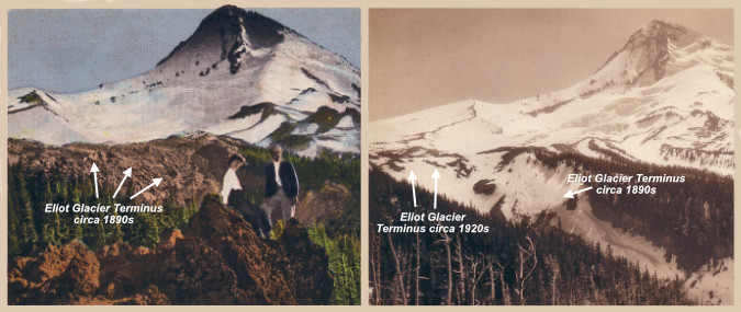
Early photo views of the Eliot Glacier’s terminus shows the river of ice already receding between the 1890s and 1920s
[click here for a large version]
The Little Ice Age faded in the 20th Century, and as the photo pair above shows, the Eliot Glacier was already receding from its recent surge by the 1920s. Today, the Eliot Glacier has retreated about a half mile from its terminus in 1889, and lost as much as half its depth to our warming climate.
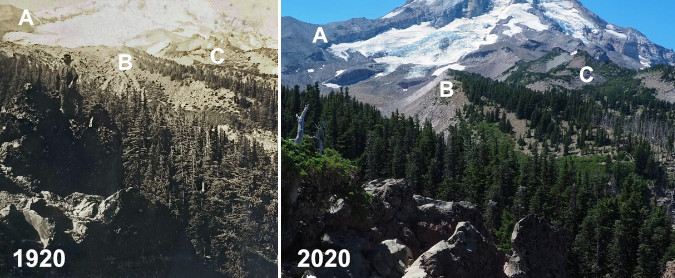
The following photo pair shows the dramatic change from 1920 to 2020. The change in the glacier’s thickness can be seen by (A) the exposed cliffs below Cooper Spur were carved into a vertical wall by the glacier at its peak. The glacier’s terminus (B) has receded dramatically over the past century, revealing the high moraines we now see rising above the Eliot Branch. A more subtle change (C) are the alpine forests gradually moving up the mountain as summer snowpacks diminish.
Another, more detailed 1920 view of the Eliot Glacier’s terminus compared to the same view in 2020 shows the radical change over the past century
[click here for a large version]
For much of the past century, these changes were gradual enough that only a few scientists and mountain climbers noticed the ongoing change. But since the turn of the millennium the pace of change has accelerated to an alarming rate as our climate warms.
This article documents this most recent period of change, over the two decades that span from 2002 to 2022, including how the landscape on the mountain, itself, as changed. The article focuses on the area around Cloud Cap and the Eliot Glacier, as viewed from the Cooper Spur trail, as this corner of the mountain has seen some of the most volatile change.
Why 2002 as a starting point? That answer has to do with technology, not climate change. That was the year that I began shooting with a digital camera. For someone who learned photography with a film camera (including plenty of spent time in the darkroom in the 1980s) the age of digital has been a revelation. Film and print paper was expensive, and while I have a lengthy archive of images going back to 1980, the digital era has allowed me to bring back hundreds of photos from a single trip to the mountain, where I might have captured a dozen during the film era that was rapidly winding down by the early 2000s.
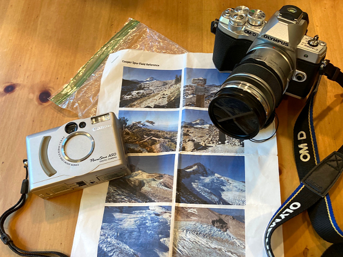
Then and now – my 2002 pocket camera and 2022 digital SLR, along with the 2002 photos I hoped to re-create.
The result is enough archived images beginning in 2022 to create a fairly thorough then-and-now comparison of the Eliot Glacier and surrounding environment along the Cooper Spur trail. The 2002 images came from a Canon A50 PowerShot pocket camera, still one of the best digital cameras I’ve owned over the years. Not long after this trip in 2002, I added my first digital SLR to my camera collection, and I have long since retired my film cameras for good. The 2020 images were captured with an Olympus EM-10 digital SLR, my fifth digital SLR, and easily my favorite (thus far).
To re-create the images from that 2002 trip, I carried a folded-up, modern-day version of a film-era proof sheet from that earlier visit in my pocket on a hike up Cooper Spur last September. Along the way, I did my best to match the scenes as I had viewed them 20 years prior. Once home, I was able to assemble 19 pairs that were close though to allow for nearly identical side-by-side comparisons. I’ve also noted a few points of interest for each image, keyed to both the 2002 and 2022 versions, to help highlight the changes that have unfolded. Because the embedded images in this article are inherently small, I’ve also posted a link below each image to a large version that will open in a new tab.
And now, how about a tour of these places in 2002 and 2022?
Change is constant… and surprising!
[click here for a large version]
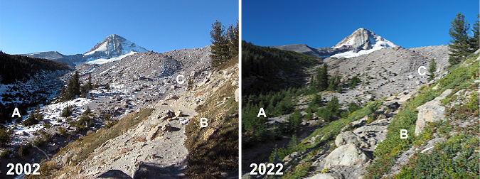
From Cloud Cap, the Timberline Trail route to Cooper Spur makes a dramatic entrance to the upper section of Tilly Jane Canyon and the first big view of Mount Hood. The changes in the first photo pair (above) are subtle, though telling. As is the case throughout the Cascades, groves of (A) Mountain hemlock continue their march to higher elevations, one more indicator of our changing climate. Lighter snowpacks (which translates to longer growing seasons) might also be the explanation for more expansive groundcover (B) of Juniper and Penstemon in the foreground. In distance (C), a pioneering Whitepark pine has survived to grow from a few feet tall to nearly 20 feet.
[click here for a large version]
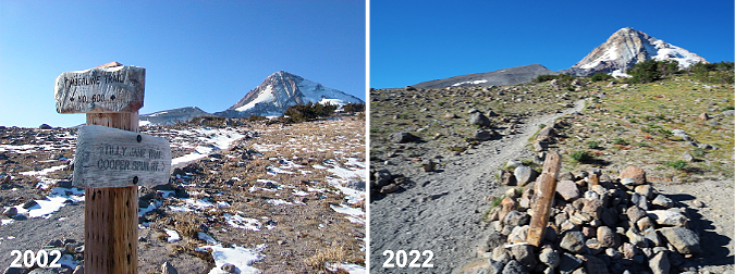
Moving further up the mountain, the Timberline Trail reaches a junction with the Tilly Jane and Cooper Spur trails (above), just above the tree line. Here, the most notable change is the battering the old trail sign has taken in 20 years of winter storms and avalanches. The two signboards were still around as recently as four years ago, but they were finally swept away in the last couple years. The bottom of the 8×8” post remains, though it had snapped off mid-way several years ago — a reminder of the power of moving winter snow in this avalanche-prone area!
[click here for a large version]
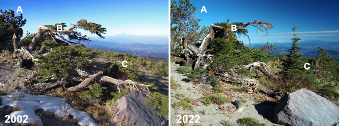
Just uphill from the trail junction, the next photo pair (above) shows a venerable Mountain hemlock that has caught the eye of many hikers over the years. Notably, the Whitebark pine just behind the hemlock (A) has grown considerably, a hopeful sign for a keystone species that has been hard hit by climate change and disease in recent decades. The hemlock (B) shows some wear, however. The upper limb that reached out toward Mount Rainier and Mount Adams has lost the battle with the winter elements, and some of the lower limbs seem to be fading, too. But in the timeless cycle of nature, a completely new Mountain hemlock (C) has grown from beneath its elder, no doubt helped along by nutrients from the decaying limbs of the older tree and the protection from the elements the old hemlock still provides.
[click here for a large version]
Further up the trail, the old stone warming hut at Cooper Spur appears (above). These shelters were built by the Civilian Conservation Corps (CCC) in the early 1930s, when the Timberline Trail was first completed. Thankfully, almost nothing has changed here, thanks to the work of volunteers who keep this old structure cabled to the ground and intact after nearly a century.
[click here for a large version]
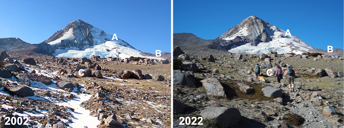
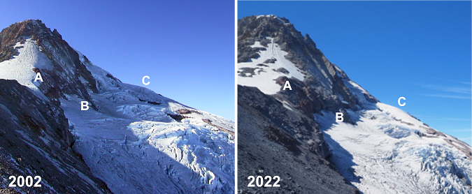
Above the old warming hut, the Cooper Spur Trail heads into tundra country (above) as it nears the 7,000 foot elevation on the mountain. From this perspective, the retreat of the Eliot Glacier starts to become apparent, especially to those familiar with the area. The rounded ice crest known to climbers as the Snow Dome (A) is notably smaller and the depth of the glacier has receded enough in the lower reaches (B) to drop beyond the top of the east moraine from this perspective. In the foreground (C) alpine wildflowers continue their march to higher elevations where only a few grasses once grew because of once-lingering snowpacks.
[click here for a large version]
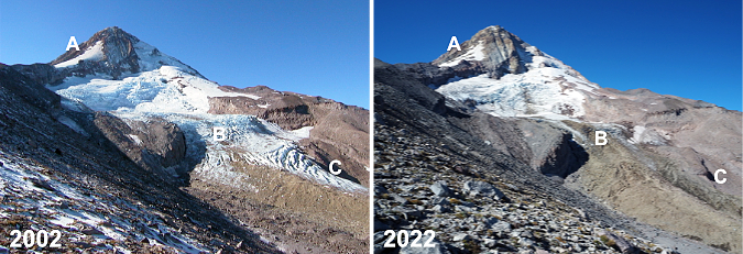
This photo pair (above) is from the first big view of the Eliot Glacier from the Cooper Spur Trail. The change over the past 20 years is unmistakable here. On the upper shoulder of the mountain (A), the snowfields that once led climbers to the summit well into summer are much smaller, making this approach in summer a very sketchy affair today, with much falling rock.
This pair of images also shows how the lower Eliot Glacier icefall has changed dramatically in just two decades of glacial retreat. The blue chaos of seracs and crevasses (B) that were once a prime ice climbing destination are now well below the “firn line”, the point at which a glacier is losing more ice than it is gaining. This line is generally where a glacier changes from blue and white clean ice to a gray mix of ice and rock, as the glacier gradually shrinks and melts in its descent. Further down (C), the decreasing depth of the glacier is especially notable where blue and white ice have disappeared.
[click here for a large version]
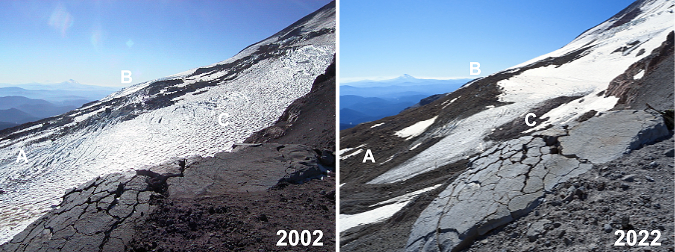
The next pair of images (above) is from an overlook just below the crest of Cooper Spur, at about the 8,000 foot elevation. Here, the Eliot Glacier is still impressive and awe inspiring as a mass of tumbling ice and wrinkled crevasses. The notable change in these views is the thinning of the ice (A and C) along the glacier’s margins, with piles of rubble appearing between lobes of flowing ice. The main icefall (B) also has some underlying rock showing as yet another sign of the thinning of the ice sheet
[click here for a large version]
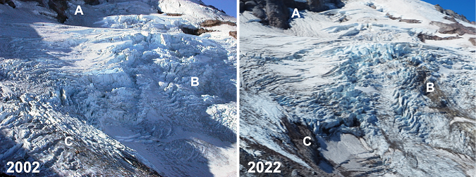
This pair (above) is simply a closer look at the main icefall from the same vantage point, showing (A) where the thinning ice mass has revealed more of the north wall of the mountain, and (b) where rock outcrops are now pushing through the icefall from below. Icefalls form because of these outcrops, so the appearance of the underlying rock is measure of the glacier depth decreasing. Twenty years ago, enough ice flowed over this outcrop to completely overwhelm it, whereas today we’re beginning to see traces of the rock beneath the glacier.
[click here for a large version]
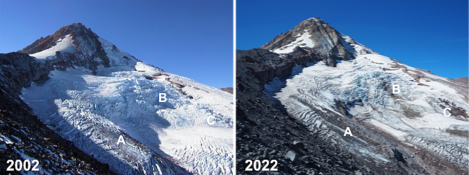
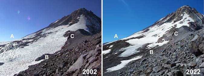
This is another view of the Eliot Glacier from just below the crest of Cooper Spur, looking across the upper part of the glacier. Here the shrinking snowfields on the climbing route above Cooper Spur (A) are more apparent, as are the exposed cliffs (B) below the north face of the mountain, where the thinning ice has revealed a vertical well. On the shoulder of the mountain, a once-crevassed section of moving glacier has slowed to become a snowfield along the margin of the glacier.
[click here for a large version]
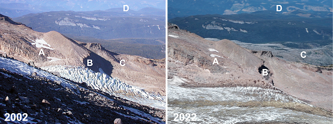
This photo pair (above) is looking across the Eliot Glacier from the crest of Cooper Spur, at about 8,500 feet elevation. It’s subtle, but the permanent snowfields (A) along the upper end of the Langille Crags are smaller today, and the lower icefall (B) is dramatically diminished, as shown in previous views. In the near distance (C) the silver ghost forest of the 2011 Dollar Lake Fire shows up today along the Mount Hood’s northern foot. In the far distance (D) the massive (and completely unsustainable) logging spree being carried out by timber giant Weyerhauser since taking over the timber holdings in the West Fork Hood River area a few years ago is painfully apparent.
[click here for a large version]
This pair (above) is a closer view of the previous set, focusing on the lower Eliot Glacier icefall. This comparison shows the thinning of the ice sheet (A and B) against the cliffs of the Langille Crags, and (C) the dramatic change on the near side of the glacier, where the firn line has moved several hundred feet up the mountain over two decades.
[click here for a large version]
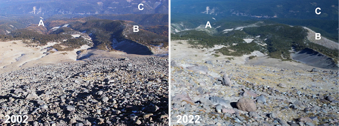
Moving away from the Eliot Glacier, this photo pair (above) shows the broad east slope of Cooper Spur from the crest, looking toward the canyon of the East Fork Hood River. The changes here are subtle, but still notable. Historic Cloud Cap Inn (A) still stands, despite being threatened by both the 2008 Gnarl Ridge Fire and 2011 Dollar Lake Fire. The ghost forests of the Gnarl Ridge Fire (B) are recovering rapidly today, filled with understory and rapidly growing Western Larch seedlings that are now 6-8 feet tall. In the distance, the human scars (C) caused by Forest Service clear cutting on the slopes of Surveyors Ridge in the 1980s and 90s are gradually fading away, too, as the forests there slowly recover.
[click here for a large version]
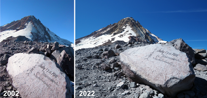
Happily, not much change at Hiroshima Rock (above) in 20 years – or even 122 years! This unlikely etching by a 1910 Japanese Climbing expedition has somehow survived more than a century of fierce ice and sand blasting, perhaps because the carving is on the leeward side of the rock? It remains a favorite touchstone for hikers passing through. Here’s an earlier blog article on this unique message from the past.
[click here for a large version]
This photo pair (above) is looking back toward the crest of Cooper Spur from a bit further up the mountain, with a feature known as Tie-in Rock in the foreground. As in previous photos, the burn scars (A) of recent forest fires can be seen in the distance. The seemingly inescapable modern phenomenon of rock stacking (B) is present on Tie-in Rock, too. Size is hard to gauge here, but the rock is about 15 feet tall and takes some effort scale — much less with rocks in hand! The Newton Clark Glacier’s retreat (C) is somewhat noticeable on the far right, though the changes are much more apparent in the image pairs that follow.
[click here for a large version]
This image pair (above) provides full-on view of the Newton Clark Glacier from Cooper Spur. This sprawling glacier faces southeast, and because it catches summer sun from sunrise until late afternoon, it is has been more visibly impacted by climate change than the northeast-facing Eliot Glacier. What was once an icefall (A) 20 years ago is now bare rock, with the glacier flowing around it. Along the margins of Cooper Spur (B and C) the shrinking expanse of the glacier is prominent.
[click here for a large version]
This is a similar view (above) looking south across the Newton Clark Glacier. Like the Eliot Glacier, the lower, blue and white ice crevasses (A) on the glacier have fallen below the firn line, replaced by a grey mix of moving rock and ice. On the far shoulder of the mountain the former icefall at the center of the glacier (B) has receded around the rock outcrop that once produced it. In the foreground (C), the thinning of the overall ice sheet is dramatic over just two decades. Mount Jefferson is visible on the far horizon.
[click here for a large version]
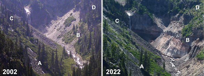
This photo pair (above) is from far below Cooper Spur, at an overlook above the Eliot Branch called Inspiration Point. I’ve included it in this series because the retreat of the glacier has had dramatic impacts downstream, too. As the glacier continues its retreat, the Eliot Branch is cutting a v-shaped channel into the soft, flat valley floor that was once beneath the glacier, releasing vast amounts of rocky debris into the stream below. Compounding that effect are periodic flood events that have repeatedly scoured the canyon. As this pair shows, the changes are extensive.
For reference, a grove of three trees (A) in the lower center of the above photo pair have dodged the mayhem, though a group just below this trio has been swept away by the Eliot Branch. Meanwhile, an entire stand of trees (B) on the west wall of the canyon has slipped away in a massive landslide, revealing raw, banded volcanic bedrock, below. Another stand of trees on the east side of the canyon (C) burned in the 2011 Dollar Lake Fire, as did the remaining trees (D) in the upper west side of the canyon. This continues to be a very active, dynamic area, with constant changes to the river channel and canyon walls.
[click here for a large version]
The final photo pair is a longer comparison of just over 120 years, as seen from Cloud Cap Inn. Mirroring the changes shown throughout this article, the Eliot is a much smaller glacier today than it was when my own grandparents were born around 1900. The mass of ice and rock (A) that once made up the terminus would be enough to fill up much of downtown Portland. The lesser-known Langille Glacier (B) has almost certainly stopped moving, and has become a series of icefields. The Coe Glacier (C) is also in retreat, despite its shady location on the north side of the mountain.
Changes like those we are seeing on Mount Hood are tough to absorb, and thus I was determined to end this article on a hopeful note. Why? Because I’m a hopeful and optimistic person to the core, but also because there is much we can do to slow the climate change that is affecting so much of our world.
[click here for a large version]
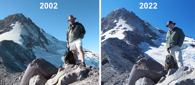
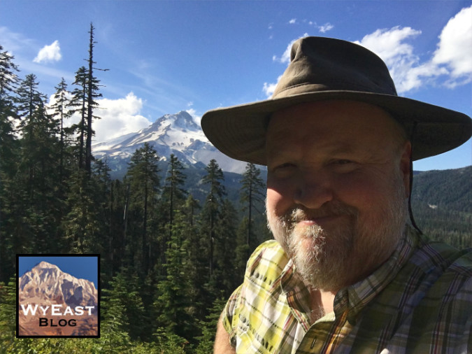
We’re not powerless against these changes, though we do have a limited time on this planet to do our part. And thus, the final image pair (above). Why, it’s me! In 2002 I was a 40-year-old with blond hair and a red beard. Fast forward to 2022 and… well, at age 60 there’s not much hair left and the beard has turned decidedly gray. Time is not on my side, to be sure, but there is plenty more I can do in my life!
The benefit of 20 more years of living is the knowledge that I can still hoof it to the top of Cooper Spur (if a lot more slowly — and feeling it more the next day, too!) and still see things I’ve never noticed before. In 2002 I was still just thinking about how I could help keep the century-old idea of a national park around Mount Hood and the Gorge alive. Two years later, I started the Mount Hood National Park Campaign website to put the idea into words and pictures (and yes, it does need an update!). Six years later, I started writing this blog to continue celebrating the future Mount Hood National Park. That’s something I can continue to do even when getting to the top of Cooper Spur is finally out of my reach!
At age 60 I know I can’t single-handedly stop the changes happening on Mount Hood and in the Gorge, whether it be from climate change to just the sheer growth in the number of people coming here. But age DOES bring the super-power of perspective that can only come from time and lived experience — and in my case, I’ve also got the photos to prove it! I’m able to put a face on those changes to help inspire caring and action toward a new vision for the future, one that focuses on sustainability and adaptation in the face of change. That’s the point of this article and the WyEast Blog, of course.
And what about the future..?
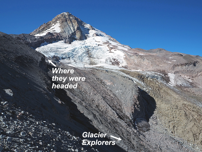
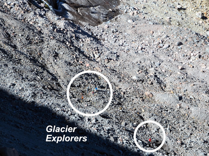
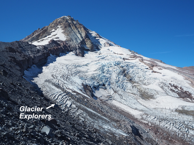
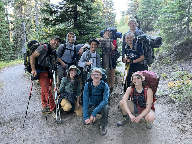
Throughout that day on Cooper Spur in September, I watched a group of young glacier explorers far below me, working their way through rock debris and over crevasses as they approached the main icefall on the Eliot Glacier. I took a few photos of the group along the way, and was thus delighted to run into them on their return to the trailhead that afternoon. I turns out they were students from Pacific University’s Outdoor Leadership Program, led by instructor Philip Friesen.
If the then-and-now photos of changes on Mount Hood are tough to look, this is where the real hopefulness in this article comes in. Phil’s program at Pacific is pointing a new generation of future leaders toward a life and careers in the outdoors that I believe will be transformational for many of the environmental challenges we’re facing today.
When I asked, here’s how Phil describes his program:
“I think the main thing to share with the world is that the students in our program focus on addressing systemic oppression and environmental issues while learning how to courageously lead others into the mountains, on rivers, and on the rock–we combine the joy of being outdoors in nature with the challenge of meeting some of our society’s biggest challenges.”
And there are many other educators like Phil out there helping young people of today turn their passion for the outdoors and their hunger to enact positive change into lifelong careers that will have a real impact in making a better world. As an old guy with only a few years left to do my part, I find this so inspiring and reassuring!
Phil Friesen (left) and his group of Pacific University students from the Outdoor Leadership Program are all smiles last September, even after a grueling climb up the Eliot Glacier!
Students in Phil’s program spend extensive time in the outdoors, learning how to hike, climb and kayak, so that they may be able to bring the outdoor experience to others over their lifetimes. This is the very best path toward conservation and sustainability, especially for our public lands. Only when we spend time there can we begin to feel the personal sense of ownership necessary to care for and protect these spaces in perpetuity.
I have great faith in what we have named “Generation Z”, and so does Phil. Young people majoring in Outdoor Leadership at Pacific are readying themselves for a life doing what they love, whether it be as a guide, ranger, naturalist or many other emerging careers in the growing outdoor industry. They’re also learning about the history of exclusion on our public lands, and the urgent need to remove barriers so that all Americans can enrich their lives in the same way that the most privileged among us already do. That hits home for them, too, as they are by far the most diverse generation in our history.
Phil plans to share these images with his students, most of whom were born around 2002, when I took that first set of photos. They will likely find them jarring, as they only know the Eliot Glacier of today, and may not realize how quickly it is fading away. But they have an abundance of passion for the environment, and I do think these photos will lend still more urgency to them in their commitment to make our world a better place.
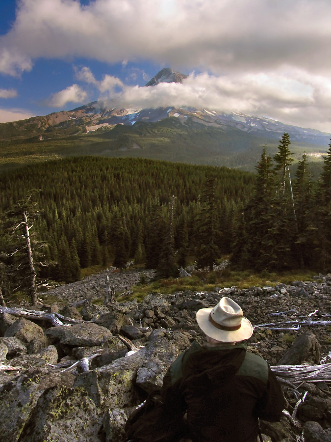
The author getting his head straight in the shadow of mighty WyEast before heading home for another week in civilization (Photo by Andy Prahl)
The real power of the Outdoor Leadership Program – and this is true for anyone who spends time in the outdoors – is the cascade of reflections that immersion in nature fosters. No matter your walk of life, time on a trail, among the trees or through mountain meadows, ensures the perspective, peace of mind and hopefulness needed to make the rest of our busy lives more successful. I refer to as my mental health time, when I get my head straight before another week of Zoom meetings and e-mails. Phil’s students are learning this early on, and I’m certain it will be as restorative and rejuvenating in their lives as it is in mine.
Phil’s group was all grins after a grueling day climbing up a glacier. Such is life when you’re 20 years old! They don’t know it yet, but they are part of what could be the most consequential generation in our history. They have no choice but to grapple with enormous challenges that my own generation has so short on. But because I do get to spend a fair amount of time around today’s Generation Z, I’m more certain than ever that they are special. They are uniquely up for the challenge. Phil’s students are way too young to know this quote that has guided since childhood, but they are nonetheless embracing it like no generation has before them:
________________
“Unless someone like you cares an awful lot,
it’s not going to get better. It’s not.”
-The Lorax
________________
And a final note to Phil Friesen and his Outdoor Leadership Program students: Thank you for the great things you are about to do!
________________
Author’s postscript: My best to all who have followed this blog over these many years! I greatly appreciate the support and especially your passion and concern for the future of our WyEast Country. I have a bunch of new articles planned for the coming year and look forward to sharing them with you!
In the meantime, I hope to see you on the trail!
Tom Kloster • January 1, 2023





Thanks for sharing these fantastic photos.
LikeLike
This is amazing work Tom. A lot of this is very interesting and personal since I (pioneered?) a “high route” above the Timberline Trail all the way around Mt Hood that I did up close and personal with these high points. (My route was generally non-technical and a hike. I’m aware of the ski route up high that is very different. I did have to dip below Reid and back up on my route too.) Thank you for this incredibly detailed historical record! Mike “GoalTech” Irving
LikeLike
Awesome as always. Technically, the digital revolution combined with the computer age allows the telling of important histories, stories and facts in a much more user-friendly manner. Imagine the photos we could have taken when younger and not encumbered with the need to ration the number of photos shot because of film. Let alone, as you have done here, create a time log of natural (or?) change. See you indeed on the trails.
LikeLike
I am not sure now long I’ve been following your blog but some years now. This last article was very impressive. I do spend lots of time hiking different trails on Wy East. In my younger years did several hikes from Cooper Spur, a place my father loved and took us to as kids. Thanks for sharing your photos.
LikeLike
Thank you Regis, Mike and Chris — appreciate you stopping by!
Mark, I have thought about that parallel universe many times — all of the trips I took during the film era and what I might have captured had digital arrived. One of my many jobs during college was selling cameras at a local camera shop, and as increasingly automated (especially autofocucs SLRs) 35mm film cameras were evolving in the 1980s, we thought THAT to be an impressive innovation! You do have to wonder what the future holds — and on that count, I surely didn’t expect my cell phone to ever compete with an SLR, but that day seems to be approaching rapidly. Appreciate you stopping by!
LikeLike
Tom, I love your writing and attention to detail. This just all makes me want to go hiking up on the mountain!
LikeLike
Thank you, Dan! 🙂
LikeLike
That was so beautiful and startling. I am 87 and have seen so many changes.
The wonderful hike from Cloud Cap to Meadows is out of my reach but the memories are still there.
LikeLike
An especially great post, Tom. I thank you for it.
Joel
LikeLike
Thank you, Joel! Flora, what I would give to have your memories! By the time I was six years old and hiking on Mount Hood, the Meadows ski resort was nearly open and that corner of the mountain changed forever. Thanks for reading — I’m honored!
LikeLike