
It is that time of year, so I will indulge in my annual plug for the Mount Hood National Park Campaign Calendar, of which all proceeds go to benefit Trailkeepers of Oregon (TKO). This article covers this year’s calendar scenes with some of their backstory, but if you’re itching to get a calendar before reading any further, here’s the link to my Zazzle store:
2023 Mount Hood National Park Calendar
Zazzle does a truly amazing job with these. They are beautifully printed on quality paper and orders typically arrive within about 10 days or so. I’ll post another link at the bottom of this article if you’d like to learn more about the images, first.
Another Year in WyEast Country…
Starting with the cover image (above), I picked an scene captured this fall, near Lolo Pass, on Mount Hood’s northwest side. This is my favorite profile of Mount Hood – a nearly perfect pyramid seemingly cut from solid stone that belies its origin as a stratovolcano. While most big Cascade volcanoes are lumpy and dome-shaped, glaciers have sculpted Mount Hood to have the many distinctive faces that often bely its volcanic origin. The sheer, towering Sandy Headwall in this view is among its most impressive.
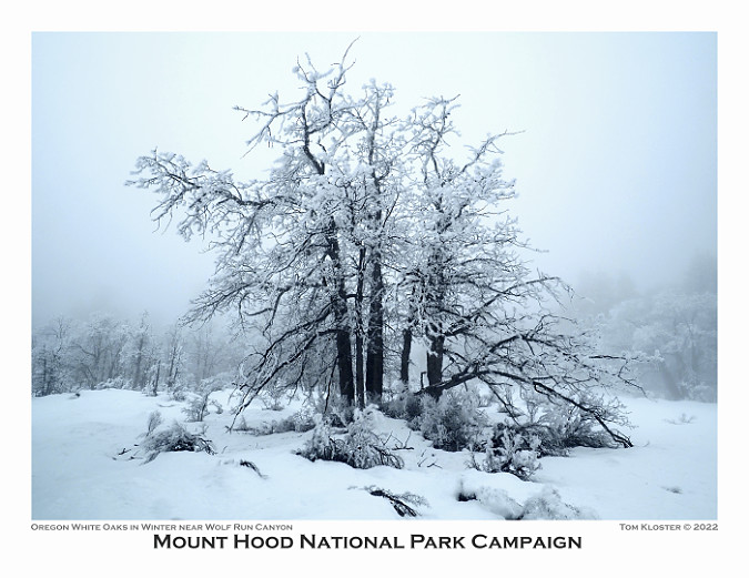
For January (above), I chose an image of a stunted group of Oregon white oak over on the east side of Mount Hood. Here, the forests transitions in the dry rain shadow of the Cascades from Ponderosa pine and Douglas fir at higher elevations, to short, tortured oaks that seldom exceed 10 or 15 feet in height – a tenth of what they might achieve under less harsh conditions. Eventually the oaks give way to the sagebrush hills of Oregon’s desert country.

Freezing fog crystals on Oregon white oak leaves
On this particular visit, freezing fog had hovered over the area for several days, leaving everything flocked in elaborate ice crystals. It’s one of my favorite weather phenomena, and it is surprisingly common in select spots on the east side of the mountain, where freezing fog often banks up against the Cascades in winter.
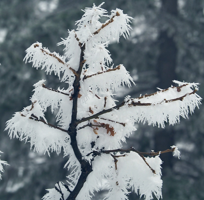
Freezing fog crystals on an Oregon white oak
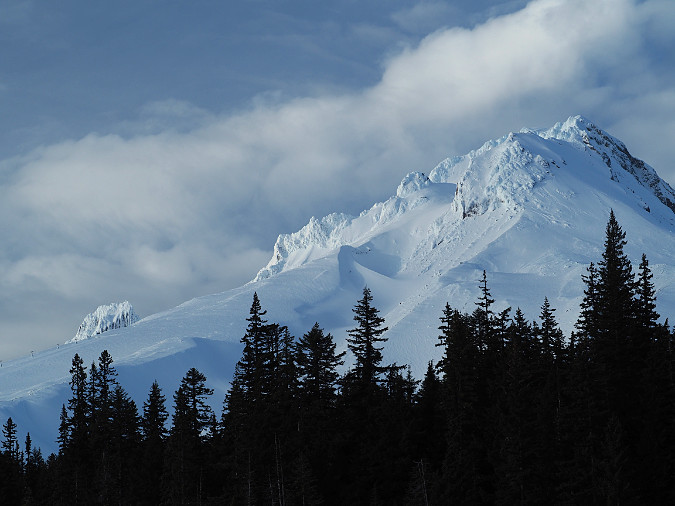
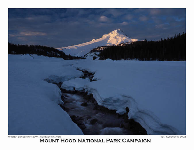
The February image (below) in the new calendar features the last light of a winter day on Mount Hood’s crater, as viewed on a snowshoe trick into the White River Canyon. From this perspective, you can visualize the extent of the mountain’s last major eruption in the 1790s. The smooth south slopes on the left that extend all the way from the crater area to Government Camp were formed by debris flows that streamed down the mountain as new lava poured out in the crater. Though it seems timeless, today’s Crater Rock — an 800-foot monolith guarding the left side of the crater — was formed during this event, and is just 230 years old!

This snowshoe trip was memorable for the changing conditions. It was a brief ray of winter sun between storms. It had been a cloudy day, with the mountain mostly hiding in the overcast. The next weather system was already moving in, but as evening approached, the clouds suddenly lifted from them mountain for about an hour. The image below was taken about 20 minutes before the calendar view, as the clouds were still lifting away from the summit. After the brief light show, sun dropped down and the mountain disappeared into clouds, once again.
Winter clouds lifting from the mountain in late afternoon
For March, I choose a sylvan scene at Columbia Hills Nature Preserve, on the north side of the Columbia River in the desert country east of Mount Hood. Here, the wildflowers were just beginning to bloom while the grove of Oregon white oak was still dormant after a cold, windy winter. The wispy spring clouds completed the scene! The Columbia Hills are a gem, and their transformation from cattle ranch to wildland over the past few decades is one of the great recent conservation stories in WyEast county.
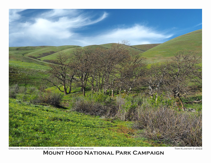
While I was setting up this photo, a pair of Western fence lizards were courting on a stack of rocks, nearby. They had found a warm, protected spot on a brisk day and didn’t seem too concerned about me. Just two friends soaking up the sun, or was it a romantic interlude? Hard to say, but they clearly were enjoying the re-emergence of spring, too.

Just friends..?
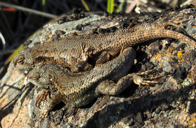
…or maybe more..?
The April calendar image (below) is a bit of an abstract made possible by weird geology and the brilliant colors of spring in the desert landscape. These are the Ortley Pinnacles, a sharply tilted layer of flood basalts that has been so uplifted that the once liquid layers of rock now stand almost on end. The bright yellow patches are Bigleaf maple flowering on the steep talus and groves (still leafless in this view) of Oregon white oak can be seen in the upper left.

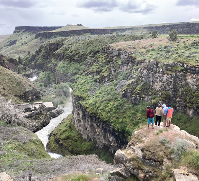
The scale of this image is a bit hard to appreciate, too, so this wider image (below) shows the river, a freight train and the 2,000-foot north wall of the Columbia River Gorge for reference. Though beautiful at any time of the year, the rainbow of colors in the east Gorge are especially striking in mid-spring.
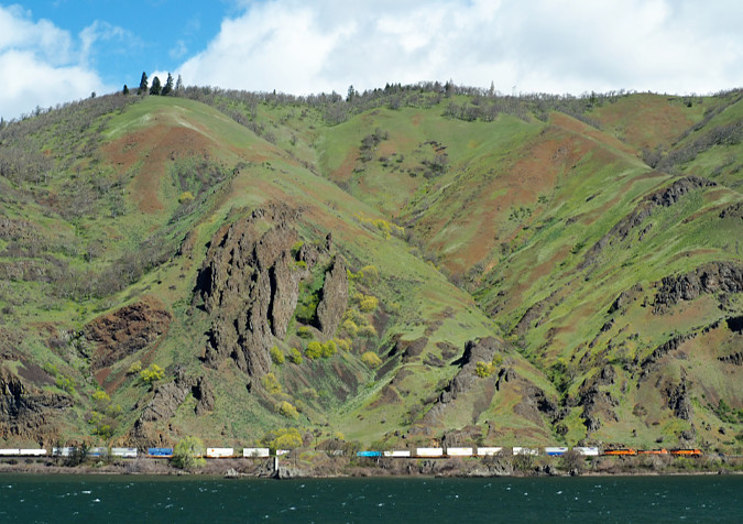
Freight train passing under the Ortley Pinnacles in the east Columbia River Gorge
Staying on the east side of Mount Hood, the May calendar image features another Columbia Hills Nature Preserve scene. This view, looking toward Mount Hood (and Mount Jefferson for the sharp-eyed), is across vast fields of yellow Arrowleaf balsamroot and blue Lupine that famously carpet the area in spring.

This is an increasingly popular place for hikers and photographers during the spring bloom, with people coming from all over the world to capture the spectacle of these meadows.
While setting up another photo, I watched an unexpected drama suddenly unfold through my lens (below). A white SUV suddenly appeared, with the driver apparently unaccustomed to driving on backroads. Rounding the corner too fast, they skidded off the soft shoulder and were quickly stuck in the ditch. Another driver soon stopped, and everyone seemed to be okay. Later, I passed a tow truck from The Dalles finally arriving to pull them out. A memorable day for these visitors, but at least they had a lovely backdrop while waiting for the tow!
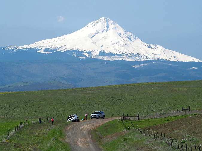
If you’re doing to ditch your car, you might has well choose a scenic spot!
For June, an image of White River Falls in all its spring runoff glory is the featured image. This is a favorite spot I’ve been visiting since the early 1980s. Over those years, it has continued to recover from its industrial past to re-emerge as one of the most striking features in the desert country east of Mount Hood. Until 1960, a small hydroelectric plant built at the turn of the 20th Century operated here, and much of the old infrastructure still remains in place as sort of an industrial ruins.
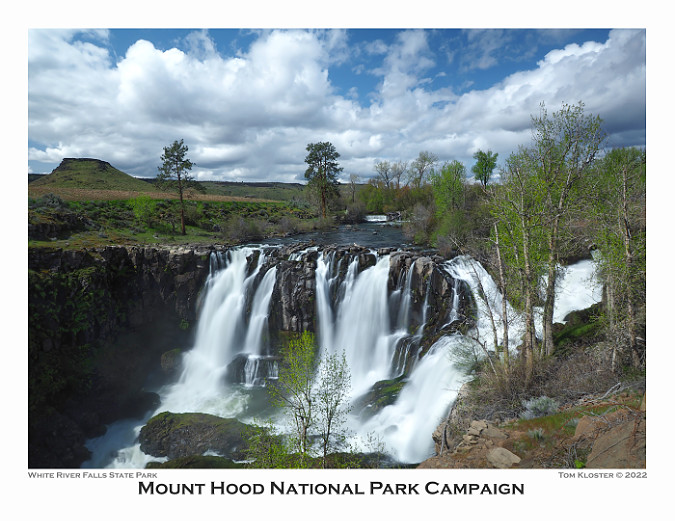
As the park gathered popularity in the late 2000s, the interior of the old power house took a real beating, with lot of tagging and senseless vandalism. Like so many parks, the steep increase in visitation is also taking a toll on the trails at White River falls, with old staircases just wearing out from the heavy use and new user paths sprouting in all directions.
In recent years, Oregon Parks and Recreation Department (OPRD) has stepped up their efforts at White River Falls, including securely enclosing the power house interior against further damage and increasing their efforts to managing tagging at the park. On-site park hosts now care for the park for from spring through fall, as well. Fact is, any park with a swimming hole is bound to deal with these issues, so it’ good to see OPRD beginning to get ahead of the problem.
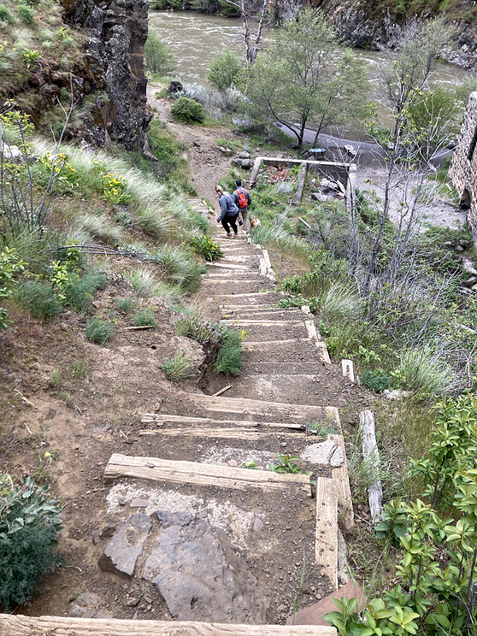
These steps made of railroad ties and concrete slabs have seen better days at White River Falls
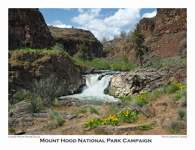
I continued the White River Falls theme in July, with a view of the lesser-known Lower White River Falls. This lovely spot is a short walk down the canyon from the historic powerhouse and is framed by desert wildflowers in early summer.
The trail to the lower falls – like most in the park – are social trails. Unfortunately, they are have become increasingly tangled and impactful as ever more new trails form with the growth in visitation. In desert environments, managing trail routes is especially important, as new user trails can leave tracks that last decades.
The good news at White River Falls is that there is a lot of park and thus much potential to spread visitors out a bit with a modest expansion of the trail system. And, the trails in the impacted areas just need some care and management to become sustainable again. Much of the work could be done by volunteers, too. Given the relative remoteness of the park, one option could be “volunteer vacation” events where trail volunteers spend a week working at a site. This would take advantage of the new restrooms and other accommodations already at the park.
Keeping hikers on the few trails that exist at White River Falls is a challenge. These hikers walked right past a closure sign.
In the coming year I’ll be sharing some concepts for expanding trail opportunities at White River Falls with an eye toward accommodating the continued growth in popularity and preserving its beauty and history. Both can be accomplished with some thoughtful planning, much of the work by volunteers.
Moving to August, I made the unusual choice of an image with people in it! That wasn’t really the plan, but these hikers walked through my setup and so I captured a few images. I later decided they added to the story of the pilgrimage experience that hiking up the shoulder of Mount Hood offers so many – in this case, the venerable trail to Cooper Spur.

I had about a dozen images from this sequence and chose one that would be anonymous. However, another consideration was an off-leash dog with the lead group. I’m a dog-lover (I currently have three) and am of the view that dogs in wilderness should always be leashed. There are lots of good reasons for this, mostly for the benefit of both wildlife and the dogs. However, this is not the law, and even in the few National Forest areas where leashes are mandated, the U.S. Forest Service does little to enforce the rules.
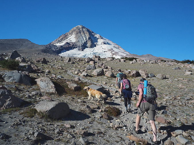
Hikers (and a hiker’s best friend) on the trail to Cooper Spur
Given that reality, I’ve got a mostly-written piece on “dog etiquette for hikers” that I will eventually post on the blog. Dog owners are just looking for a great outdoor experience, after all, and mostly don’t realize the impact of off-leash pets, so in the end, managing how we take our pets into the wild really depends on awareness and culture change. I’m already seeing that happen, albeit slowly.
For September, I chose an image of the Eliot Glacier from the same Cooper Spur hike featured in the previous month. The Eliot remains Mount Hood’s largest glacier, and the view into its mass of crevasses and seracs is truly breathtaking from the upper reaches of Cooper Spur. Yet, for old timers like me, the changes in the glacier in recent years are increasingly worrisome. To put a face on the change over the past couple of decades, I’ll be posting an article soon that does exactly that: side-by-side comparisons of change over the past 20 years. The differences are startling, and hopefully helpful inspiration to do our part to address global climate change.

A pleasant surprise that September day on Cooper Spur were swarms of Ladybugs all along the crest! Entomologists have studied this phenomenon extensively, and the thinking is that when bugs from opposite valleys meet along ridgetops to mate, they are rewarded with genetic diversity. In the moment, however, it was just a wild and crazy party atmosphere among the little beetles!

Scenic spot for a Ladybug convention!
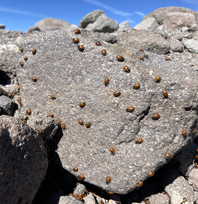
Lots of action, here – beetle romance in the air!
Moving on to October, I chose this image of Mount Hood from the shoulder of Vista Ridge. I’ve spent a lot of time on this side of the mountain over the past couple of decades, and like much of the mountain, this corner has seen a rapid increase in visitation. The Vista Ridge trailhead is really just a stubbed logging road, and thus ill equipped to handle the amount of traffic it sees, with cars park at crazy angles and backed up down the road on busy weekends.
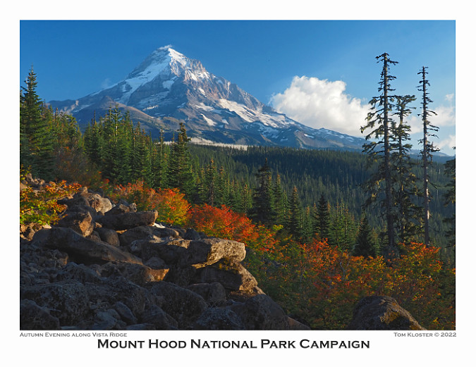
Therefore, another piece I’m planning to post in the coming year is a new trailhead concept for Vista Ridge that I’m actively working on with Trailkeepers of Oregon (TKO) to advance.
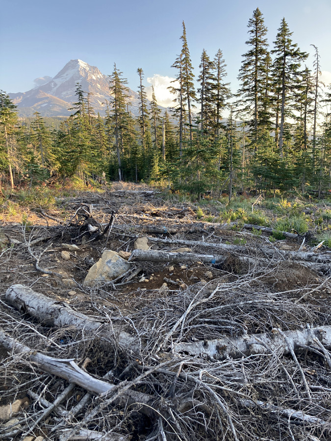
The idea is to solve the current trailhead crowding issues while also converting a section of the current access road to become an accessible trail – turning the roadside view captured above into a trail destination for less able-bodied visitors or those with mobility devices. Far too few of these opportunities exist on the mountain, so this seems like a good starting point.
Future Vista Ridge trailhead? Maybe…
The relocated Vista Ridge parking area would move downhill by a half mile to a recently logged area (above) that is already disturbed and better situated as a trailhead. Some of this work could be done by volunteers, but it will take a partnership with the Forest Service to make this happen. More to come on this concept!
For November, I chose a wintery scene from the Ponderosa pine country of Lookout Mountain, located just east of Mount Hood in the Badger Creek Wilderness. This image is from still another freezing frost event, along with a skiff of snow on the ground from an early winter storm.
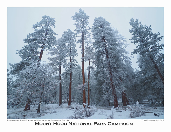
The contrast of rust-colored Ponderosa bark to the cool blues and greens of frost-covered pine needles is truly striking during these events. The effect is also fleeting, as even a light breeze can shake the ice crystals loose in a miniature snow flurry, and a break in the clouds would quickly melt them away.
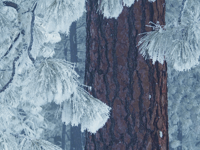
Freezing fog scene in a Ponderosa forest

Ice crystals decorating Ponderosa pine limbs
Last up, the December image is from another winter trek into the White River Canyon (below). On this quiet trip, I followed another snowshoer and her dog into the canyon on a weekday afternoon when crowds on the mountain were few.
Heading into the White River Canyon in winter
On the way back down the canyon, I set up the camera for some evening views of the mountain using long exposures to capture the movement of the White River. This image (below) ended up being my pick for the calendar.
However, I wrestled between a couple of images from this trip for the calendar, both taken from exactly the same spot, though about 20 minutes apart. So, if you like pink alpenglow scenes, you’ll be disappointed in my choice of the previous photo for the calendar! The image below was last light on the mountain that day.

Alpenglow along the White River
As with most years, I chose the 13 calendar images for 2023 from about 150 “keepers” that I had pulled aside over the year as favorites. The best thing about putting the calendar together each year is sharing my experiences in WyEast Country, while also challenging myself to see new places, or see familiar places in new ways. Every year I learn new so many new secrets about Mount Hood and the Gorge!
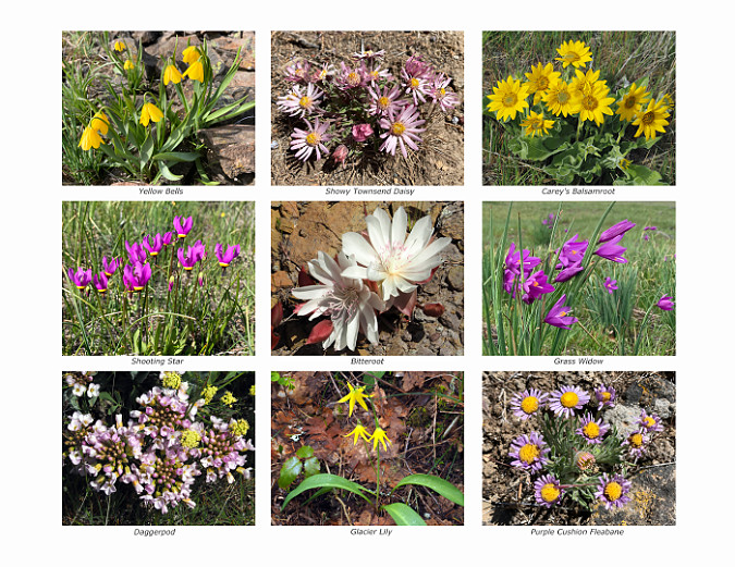
Also among the photos each year are nine wildflower images on the back of the calendar. My thanks to Paul Slichter’s for his terrific Flora and Fauna Northwest website and to the Oregon Wildflowers Facebook group administered by Greg Lief and Adam Schneider for their help on identifying several of these beauties.
So, there’s the backstory! If you’d like a calendar, they’re easy to order online from Zazzle – and to repeat, all proceeds go to Trailkeepers of Oregon (TKO), as always. Just follow this link:
2023 Mount Hood National Park Campaign Calendar
As always, thanks for following the WyEast Blog for another year. I hope to run into you on the trail sometime in 2023!

Tom Kloster | December 2022

Bravo, Tom! Your photos, your passion for the Mount Hood country and its landscapes, your writing — and your calendar supporting TKO: Wow! Inspiring, beautiful and thoughtful. One of the best blogs going in our corner of the world. … I do hope you put a bunch of your writings and photos together into a book one of these days. — A big fan in The Dalles.
LikeLiked by 1 person
Thank you, Dan! 🙂
LikeLike