20 years of change on Cooper Spur… and the future?

Workers cutting beams from solid pine trunks for the new Cloud Cap Inn during the summer of 1888. The (then) surging Eliot glacier loomed just beyond Cloud Cap in those early days (Author’s note: this is a modified historical image that I have colorized to bring the sense of the distant past a bit closer to our present-day world)

[click here for a large version]

When the builders of Cloud Cap Inn began construction in earnest in early summer 1889, the backdrop for Mount Hood’s first mountain lodge was radically different than today. The Northern Hemisphere was experiencing the final decades of a brief, still unexplained cooling period known as the Little Ice Age that stretched from the 1500s through the 1800s. 

The cooling was modest, but enough to surge the Eliot Glacier down to the tree line, nearly filling the deep trough between the high lateral moraines that were created in the last true ice age, thousands of years prior. The debris-covered terminus (or snout) of the Eliot Glacier was in plain view from Cloud Cap, directly behind the workers on the left side of the photo, above. It was formidable wall of glacial ice and rock rising nearly 300 feet above the valley floor.

Early photo views of the Eliot Glacier’s terminus shows the river of ice already receding between the 1890s and 1920s

[click here for a large version]

The Little Ice Age faded in the 20th Century, and as the photo pair above shows, the Eliot Glacier was already receding from its recent surge by the 1920s. Today, the Eliot Glacier has retreated about a half mile from its terminus in 1889, and lost as much as half its depth to our warming climate. 

The following photo pair shows the dramatic change from 1920 to 2020. The change in the glacier’s thickness can be seen by (A) the exposed cliffs below Cooper Spur were carved into a vertical wall by the glacier at its peak. The glacier’s terminus (B) has receded dramatically over the past century, revealing the high moraines we now see rising above the Eliot Branch. A more subtle change (C) are the alpine forests gradually moving up the mountain as summer snowpacks diminish.

Another, more detailed 1920 view of the Eliot Glacier’s terminus compared to the same view in 2020 shows the radical change over the past century

[click here for a large version]

For much of the past century, these changes were gradual enough that only a few scientists and mountain climbers noticed the ongoing change. But since the turn of the millennium the pace of change has accelerated to an alarming rate as our climate warms.

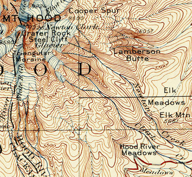
This article documents this most recent period of change, over the two decades that span from 2002 to 2022, including how the landscape on the mountain, itself, as changed. The article focuses on the area around Cloud Cap and the Eliot Glacier, as viewed from the Cooper Spur trail, as this corner of the mountain has seen some of the most volatile change.

Why 2002 as a starting point? That answer has to do with technology, not climate change. That was the year that I began shooting with a digital camera. For someone who learned photography with a film camera (including plenty of spent time in the darkroom in the 1980s) the age of digital has been a revelation. Film and print paper was expensive, and while I have a lengthy archive of images going back to 1980, the digital era has allowed me to bring back hundreds of photos from a single trip to the mountain, where I might have captured a dozen during the film era that was rapidly winding down by the early 2000s. 

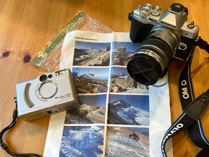
Then and now – my 2002 pocket camera and 2022 digital SLR, along with the 2002 photos I hoped to re-create.

The result is enough archived images beginning in 2022 to create a fairly thorough then-and-now comparison of the Eliot Glacier and surrounding environment along the Cooper Spur trail. The 2002 images came from a Canon A50 PowerShot pocket camera, still one of the best digital cameras I’ve owned over the years. Not long after this trip in 2002, I added my first digital SLR to my camera collection, and I have long since retired my film cameras for good. The 2020 images were captured with an Olympus EM-10 digital SLR, my fifth digital SLR, and easily my favorite (thus far).

To re-create the images from that 2002 trip, I carried a folded-up, modern-day version of a film-era proof sheet from that earlier visit in my pocket on a hike up Cooper Spur last September. Along the way, I did my best to match the scenes as I had viewed them 20 years prior. Once home, I was able to assemble 19 pairs that were close though to allow for nearly identical side-by-side comparisons. I’ve also noted a few points of interest for each image, keyed to both the 2002 and 2022 versions, to help highlight the changes that have unfolded. Because the embedded images in this article are inherently small, I’ve also posted a link below each image to a large version that will open in a new tab.

And now, how about a tour of these places in 2002 and 2022?

Change is constant… and surprising!

[click here for a large version]

From Cloud Cap, the Timberline Trail route to Cooper Spur makes a dramatic entrance to the upper section of Tilly Jane Canyon and the first big view of Mount Hood. The changes in the first photo pair (above) are subtle, though telling. As is the case throughout the Cascades, groves of (A) Mountain hemlock continue their march to higher elevations, one more indicator of our changing climate. Lighter snowpacks (which translates to longer growing seasons) might also be the explanation for more expansive groundcover (B) of Juniper and Penstemon in the foreground. In distance (C), a pioneering Whitepark pine has survived to grow from a few feet tall to nearly 20 feet.

[click here for a large version]

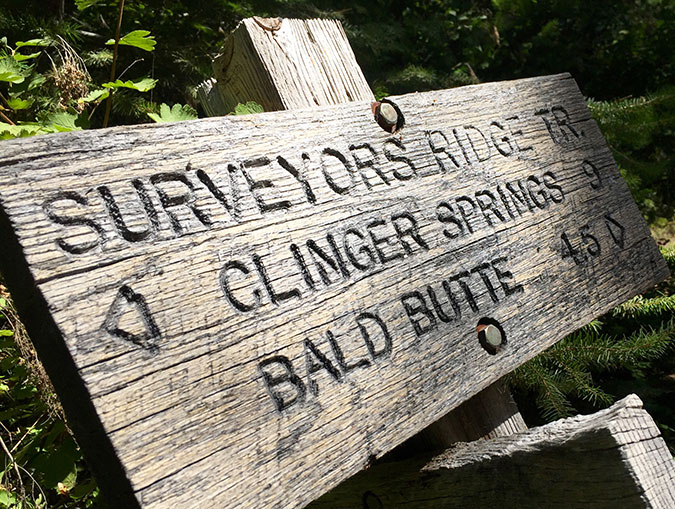
Moving further up the mountain, the Timberline Trail reaches a junction with the Tilly Jane and Cooper Spur trails (above), just above the tree line. Here, the most notable change is the battering the old trail sign has taken in 20 years of winter storms and avalanches.  The two signboards were still around as recently as four years ago, but they were finally swept away in the last couple years. The bottom of the 8×8” post remains, though it had snapped off mid-way several years ago — a reminder of the power of moving winter snow in this avalanche-prone area! 

[click here for a large version]

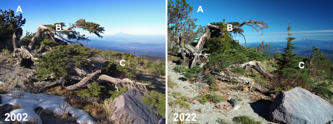
Just uphill from the trail junction, the next photo pair (above) shows a venerable Mountain hemlock  that has caught the eye of many hikers over the years. Notably, the Whitebark pine just behind the hemlock (A) has grown considerably, a hopeful sign for a keystone species that has been hard hit by climate change and disease in recent decades. The hemlock (B) shows some wear, however. The upper limb that reached out toward Mount Rainier and Mount Adams has lost the battle with the winter elements, and some of the lower limbs seem to be fading, too. But in the timeless cycle of nature, a completely new Mountain hemlock (C) has grown from beneath its elder, no doubt helped along by nutrients from the decaying limbs of the older tree and the protection from the elements the old hemlock still provides.

[click here for a large version]

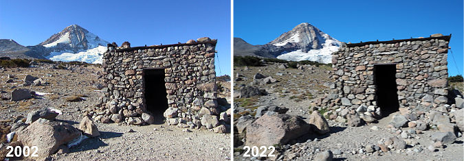
Further up the trail, the old stone warming hut at Cooper Spur appears (above). These shelters were built by the Civilian Conservation Corps (CCC) in the early 1930s, when the Timberline Trail was first completed. Thankfully, almost nothing has changed here, thanks to the work of volunteers who keep this old structure cabled to the ground and intact after nearly a century.

[click here for a large version]

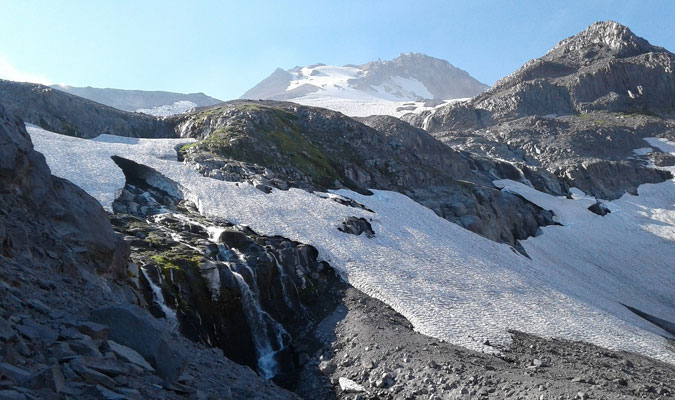
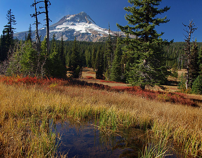
Above the old warming hut, the Cooper Spur Trail heads into tundra country (above) as it nears the 7,000 foot elevation on the mountain. From this perspective, the retreat of the Eliot Glacier starts to become apparent, especially to those familiar with the area. The rounded ice crest known to climbers as the Snow Dome (A) is notably smaller and the depth of the glacier has receded enough in the lower reaches (B) to drop beyond the top of the east moraine from this perspective. In the foreground (C) alpine wildflowers continue their march to higher elevations where only a few grasses once grew because of once-lingering snowpacks.

[click here for a large version]

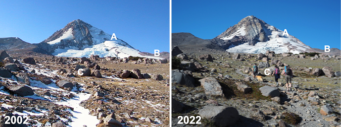
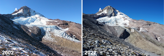
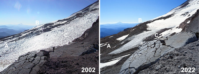
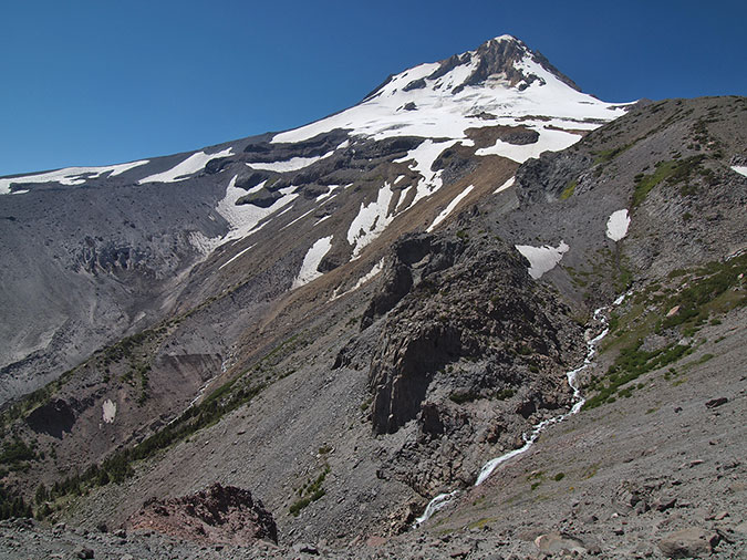
This photo pair (above) is from the first big view of the Eliot Glacier from the Cooper Spur Trail. The change over the past 20 years is unmistakable here. On the upper shoulder of the mountain (A), the snowfields that once led climbers to the summit well into summer are much smaller, making this approach in summer a very sketchy affair today, with much falling rock. 

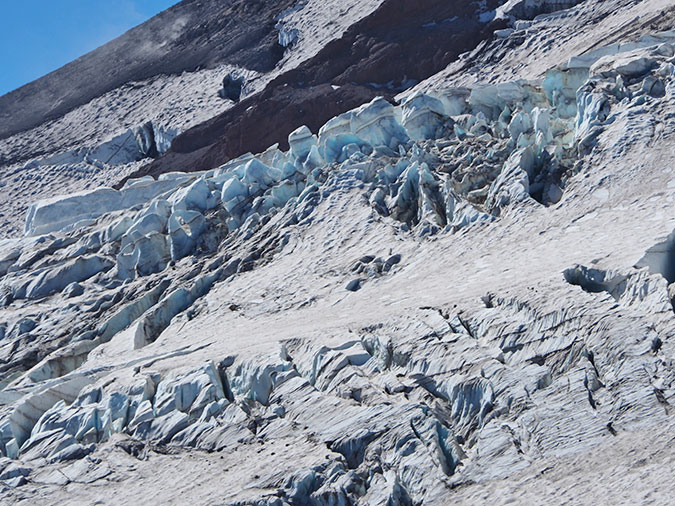
This pair of images also shows how the lower Eliot Glacier icefall has changed dramatically in just two decades of glacial retreat. The blue chaos of seracs and crevasses (B) that were once a prime ice climbing destination are now well below the “firn line”, the point at which a glacier is losing more ice than it is gaining. This line is generally where a glacier changes from blue and white clean ice to a gray mix of ice and rock, as the glacier gradually shrinks and melts in its descent. Further down (C), the decreasing depth of the glacier is especially notable where blue and white ice have disappeared.

[click here for a large version]

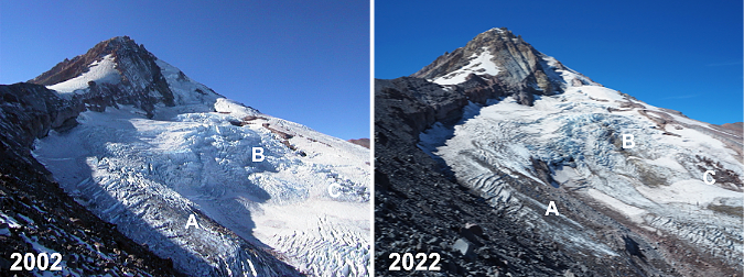
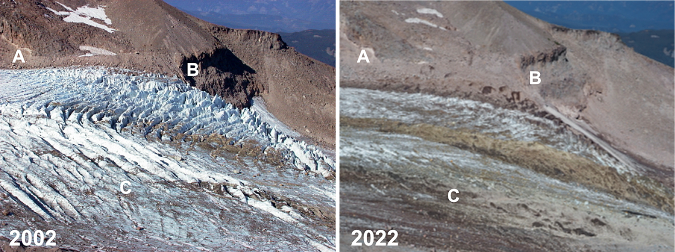
The next pair of images (above) is from an overlook just below the crest of Cooper Spur, at about the 8,000 foot elevation. Here, the Eliot Glacier is still impressive and awe inspiring as a mass of tumbling ice and wrinkled crevasses. The notable change in these views is the thinning of the ice (A and C) along the glacier’s margins, with piles of rubble appearing between lobes of flowing ice. The main icefall (B) also has some underlying rock showing as yet another sign of the thinning of the ice sheet

[click here for a large version]

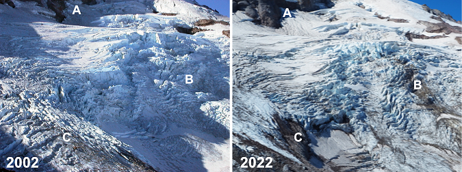
This pair (above) is simply a closer look at the main icefall from the same vantage point, showing (A) where the thinning ice mass has revealed more of the north wall of the mountain, and (b) where rock outcrops are now pushing through the icefall from below. Icefalls form because of these outcrops, so the appearance of the underlying rock is measure of the glacier depth decreasing. Twenty years ago, enough ice flowed over this outcrop to completely overwhelm it, whereas today we’re beginning to see traces of the rock beneath the glacier.

[click here for a large version]

This is another view of the Eliot Glacier from just below the crest of Cooper Spur, looking across the upper part of the glacier. Here the shrinking snowfields on the climbing route above Cooper Spur (A) are more apparent, as are the exposed cliffs (B) below the north face of the mountain, where the thinning ice has revealed a vertical well. On the shoulder of the mountain, a once-crevassed section of moving glacier has slowed to become a snowfield along the margin of the glacier.

[click here for a large version]

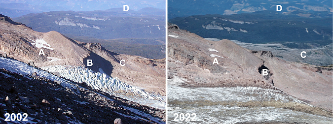
This photo pair (above) is looking across the Eliot Glacier from the crest of Cooper Spur, at about 8,500 feet elevation. It’s subtle, but the permanent snowfields (A) along the upper end of the Langille Crags are smaller today, and the lower icefall (B) is dramatically diminished, as shown in previous views. In the near distance (C) the silver ghost forest of the 2011 Dollar Lake Fire shows up today along the Mount Hood’s northern foot. In the far distance (D) the massive (and completely unsustainable) logging spree being carried out by timber giant Weyerhauser since taking over the timber holdings in the West Fork Hood River area a few years ago is painfully apparent.

[click here for a large version]

This pair (above) is a closer view of the previous set, focusing on the lower Eliot Glacier icefall. This comparison shows the thinning of the ice sheet (A and B) against the cliffs of the Langille Crags, and (C) the dramatic change on the near side of the glacier, where the firn line has moved several hundred feet up the mountain over two decades.

[click here for a large version]

Moving away from the Eliot Glacier, this photo pair (above) shows the broad east slope of Cooper Spur from the crest, looking toward the canyon of the East Fork Hood River. The changes here are subtle, but still notable. Historic Cloud Cap Inn (A) still stands, despite being threatened by both the 2008 Gnarl Ridge Fire and 2011 Dollar Lake Fire. The ghost forests of the Gnarl Ridge Fire (B) are recovering rapidly today, filled with understory and rapidly growing Western Larch seedlings that are now 6-8 feet tall. In the distance, the human scars (C) caused by Forest Service clear cutting on the slopes of Surveyors Ridge in the 1980s and 90s are gradually fading away, too, as the forests there slowly recover.

[click here for a large version]

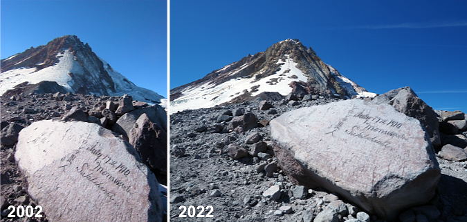
Happily, not much change at Hiroshima Rock (above) in 20 years – or even 122 years! This unlikely etching by a 1910 Japanese Climbing expedition has somehow survived more than a century of fierce ice and sand blasting, perhaps because the carving is on the leeward side of the rock? It remains a favorite touchstone for hikers passing through. Here’s an earlier blog article on this unique message from the past.

[click here for a large version]

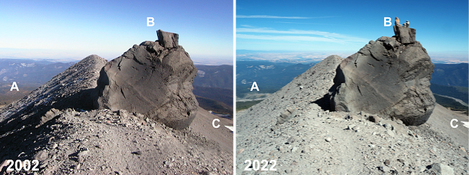
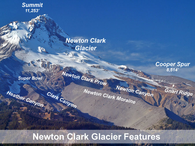
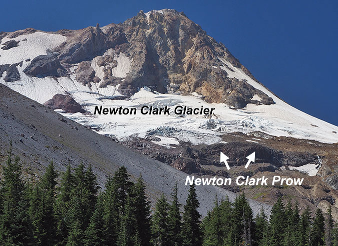
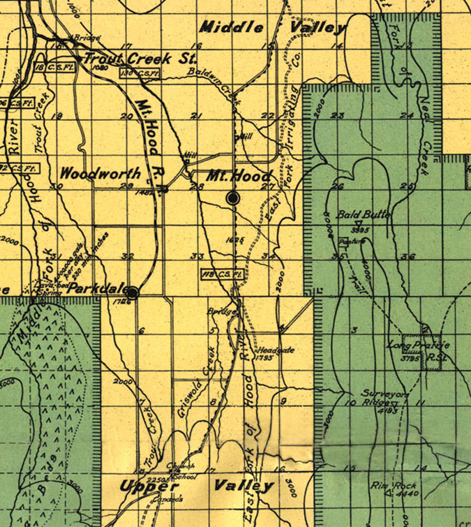
This photo pair (above) is looking back toward the crest of Cooper Spur from a bit further up the mountain, with a feature known as Tie-in Rock in the foreground. As in previous photos, the burn scars (A) of recent forest fires can be seen in the distance. The seemingly inescapable modern phenomenon of rock stacking (B) is present on Tie-in Rock, too. Size is hard to gauge here, but the rock is about 15 feet tall and takes some effort scale — much less with rocks in hand! The Newton Clark Glacier’s retreat (C) is somewhat noticeable on the far right, though the changes are much more apparent in the image pairs that follow.

[click here for a large version]

This image pair (above) provides full-on view of the Newton Clark Glacier from Cooper Spur. This sprawling glacier faces southeast, and because it catches summer sun from sunrise until late afternoon, it is has been more visibly impacted by climate change than the northeast-facing Eliot Glacier. What was once an icefall (A) 20 years ago is now bare rock, with the glacier flowing around it. Along the margins of Cooper Spur (B and C) the shrinking expanse of the glacier is prominent.

[click here for a large version]

This is a similar view (above) looking south across the Newton Clark Glacier. Like the Eliot Glacier, the lower, blue and white ice crevasses (A) on the glacier have fallen below the firn line, replaced by a grey mix of moving rock and ice. On the far shoulder of the mountain the former icefall at the center of the glacier (B) has receded around the rock outcrop that once produced it. In the foreground (C), the thinning of the overall ice sheet is dramatic over just two decades. Mount Jefferson is visible on the far horizon.

[click here for a large version]

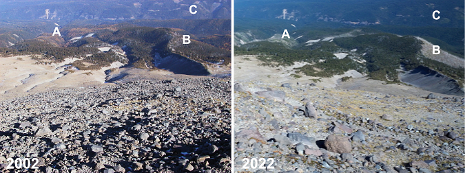
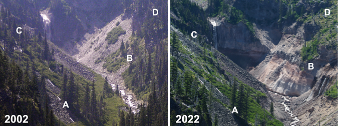
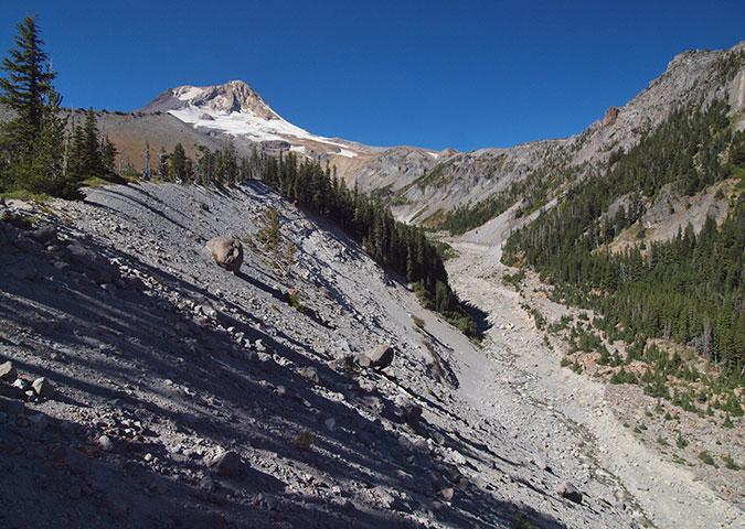
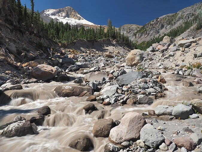
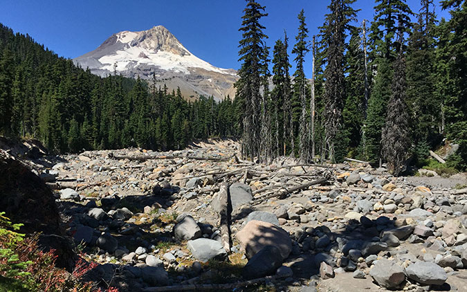
This photo pair (above) is from far below Cooper Spur, at an overlook above the Eliot Branch called Inspiration Point. I’ve included it in this series because the retreat of the glacier has had dramatic impacts downstream, too. As the glacier continues its retreat, the Eliot Branch is cutting a v-shaped channel into the soft, flat valley floor that was once beneath the glacier, releasing vast amounts of rocky debris into the stream below. Compounding that effect are periodic flood events that have repeatedly scoured the canyon. As this pair shows, the changes are extensive. 

For reference, a grove of three trees (A) in the lower center of the above photo pair have dodged the mayhem, though a group just below this trio has been swept away by the Eliot Branch. Meanwhile, an entire stand of trees (B) on the west wall of the canyon has slipped away in a massive landslide, revealing raw, banded volcanic bedrock, below. Another stand of trees on the east side of the canyon (C) burned in the 2011 Dollar Lake Fire, as did the remaining trees (D) in the upper west side of the canyon. This continues to be a very active, dynamic area, with constant changes to the river channel and canyon walls.

[click here for a large version]

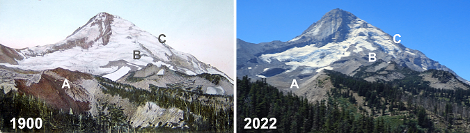
The final photo pair is a longer comparison of just over 120 years, as seen from Cloud Cap Inn. Mirroring the changes shown throughout this article, the Eliot is a much smaller glacier today than it was when my own grandparents were born around 1900. The mass of ice and rock (A) that once made up the terminus would be enough to fill up much of downtown Portland. The lesser-known Langille Glacier (B) has almost certainly stopped moving, and has become a series of icefields. The Coe Glacier (C) is also in retreat, despite its shady location on the north side of the mountain.

Changes like those we are seeing on Mount Hood are tough to absorb, and thus I was determined to end this article on a hopeful note. Why? Because I’m a hopeful and optimistic person to the core, but also because there is much we can do to slow the climate change that is affecting so much of our world.

[click here for a large version]

We’re not powerless against these changes, though we do have a limited time on this planet to do our part. And thus, the final image pair (above). Why, it’s me! In 2002 I was a 40-year-old with blond hair and a red beard. Fast forward to 2022 and… well, at age 60 there’s not much hair left and the beard has turned decidedly gray. Time is not on my side, to be sure, but there is plenty more I can do in my life!

The benefit of 20 more years of living is the knowledge that I can still hoof it to the top of Cooper Spur (if a lot more slowly — and feeling it more the next day, too!) and still see things I’ve never noticed before. In 2002 I was still just thinking about how I could help keep the century-old idea of a national park around Mount Hood and the Gorge alive. Two years later, I started the Mount Hood National Park Campaign website to put the idea into words and pictures (and yes, it does need an update!). Six years later, I started writing this blog to continue celebrating the future Mount Hood National Park. That’s something I can continue to do even when getting to the top of Cooper Spur is finally out of my reach!

At age 60 I know I can’t single-handedly stop the changes happening on Mount Hood and in the Gorge, whether it be from climate change to just the sheer growth in the number of people coming here. But age DOES bring the super-power of perspective that can only come from time and lived experience — and in my case, I’ve also got the photos to prove it! I’m able to put a face on those changes to help inspire caring and action toward a new vision for the future, one that focuses on sustainability and adaptation in the face of change. That’s the point of this article and the WyEast Blog, of course.

And what about the future..?

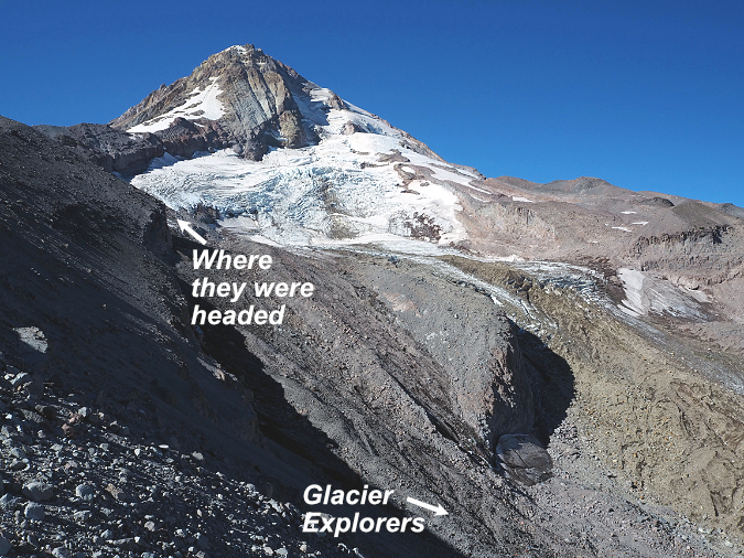
Throughout that day on Cooper Spur in September, I watched a group of young glacier explorers far below me, working their way through rock debris and over crevasses as they approached the main icefall on the Eliot Glacier. I took a few photos of the group along the way, and was thus delighted to run into them on their return to the trailhead that afternoon. I turns out they were students from Pacific University’s Outdoor Leadership Program, led by instructor Philip Friesen. 

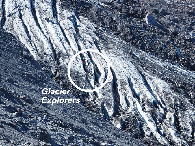
If the then-and-now photos of changes on Mount Hood are tough to look, this is where the real hopefulness in this article comes in. Phil’s program at Pacific is pointing a new generation of future leaders toward a life and careers in the outdoors that I believe will be transformational for many of the environmental challenges we’re facing today. 

When I asked, here’s how Phil describes his program:

“I think the main thing to share with the world is that the students in our program focus on addressing systemic oppression and environmental issues while learning how to courageously lead others into the mountains, on rivers, and on the rock–we combine the joy of being outdoors in nature with the challenge of meeting some of our society’s biggest challenges.”

And there are many other educators like Phil out there helping young people of today turn their passion for the outdoors and their hunger to enact positive change into lifelong careers that will have a real impact in making a better world. As an old guy with only a few years left to do my part, I find this so inspiring and reassuring!

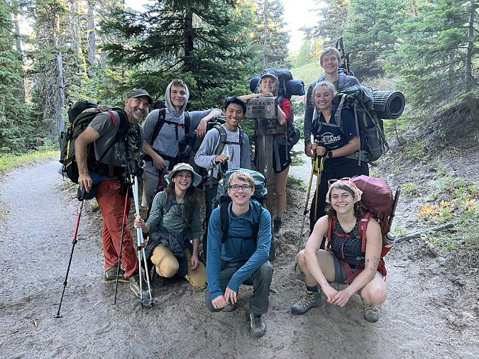
Phil Friesen (left) and his group of Pacific University students from the Outdoor Leadership Program are all smiles last September, even after a grueling climb up the Eliot Glacier!

Students in Phil’s program spend extensive time in the outdoors, learning how to hike, climb and kayak, so that they may be able to bring the outdoor experience to others over their lifetimes. This is the very best path toward conservation and sustainability, especially for our public lands. Only when we spend time there can we begin to feel the personal sense of ownership necessary to care for and protect these spaces in perpetuity.

I have great faith in what we have named “Generation Z”, and so does Phil. Young people majoring in Outdoor Leadership at Pacific are readying themselves for a life doing what they love, whether it be as a guide, ranger, naturalist or many other emerging careers in the growing outdoor industry. They’re also learning about the history of exclusion on our public lands, and the urgent need to remove barriers so that all Americans can enrich their lives in the same way that the most privileged among us already do. That hits home for them, too, as they are by far the most diverse generation in our history. 

Phil plans to share these images with his students, most of whom were born around 2002, when I took that first set of photos. They will likely find them jarring, as they only know the Eliot Glacier of today, and may not realize how quickly it is fading away. But they have an abundance  of passion for the environment, and I do think these photos will lend still more urgency to them in their commitment to make our world a better place.

The author getting his head straight in the shadow of mighty WyEast before heading home for  another week in civilization (Photo by Andy Prahl)

The real power of the Outdoor Leadership Program – and this is true for anyone who spends time in the outdoors – is the cascade of reflections that immersion in nature fosters. No matter your walk of life, time on a trail, among the trees or through mountain meadows, ensures the perspective, peace of mind and hopefulness needed to make the rest of our busy lives more successful. I refer to as my mental health time, when I get my head straight before another week of Zoom meetings and e-mails. Phil’s students are learning this early on, and I’m certain it will be as restorative and rejuvenating in their lives as it is in mine.

Phil’s group was all grins after a grueling day climbing up a glacier. Such is life when you’re 20 years old! They don’t know it yet, but they are part of what could be the most consequential generation in our history. They have no choice but to grapple with enormous challenges that my own generation has so short on. But because I do get to spend a fair amount of time around today’s Generation Z, I’m more certain than ever that they are special. They are uniquely up for the challenge. Phil’s students are way too young to know this quote that has guided since childhood, but they are nonetheless embracing it like no generation has before them:

________________

“Unless someone like you cares an awful lot,

it’s not going to get better. It’s not.”

-The Lorax

________________

And a final note to Phil Friesen and his Outdoor Leadership Program students: Thank you for the great things you are about to do!

________________

Author’s postscript: My best to all who have followed this blog over these many years! I greatly appreciate the support and especially your passion and concern for the future of our WyEast Country. I have a bunch of new articles planned for the coming year and look forward to sharing them with you!

In the meantime, I hope to see you on the trail!

Tom Kloster • January 1, 2023

Who was Newton Clark?

The Newton Clark Glacier flows from Mount Hood’s east face

High on Mount Hood’s broad east face is the Newton Clark Glacier, third largest of the twelve named glaciers on the mountain. Many assume a hyphen must be missing in what appears to be two surnames, especially since the two major glacial outflows from this glacier are separately known as Newton Creek and Clark Creek. Who is this Newton character… and what about Clark?

Instead, it turns out that Newton Clark was just one man who made his place in local history as one of the early surveyors mapping the Mount Hood area. And in a rarity among place names in Oregon, his full name made it to our maps, where our modern naming rules limit honorary place names to surnames. It also turns out that nearby Surveyor’s Ridge, with its popular mountain biking trail, is also named for Newton Clark, albeit anonymously.

Topo map of the Newton Clark Glacier on Mount Hood’s east face

The sprawling glacier named for Newton Clark is unique among Mount Hood’s glaciers: it’s wider than it is long! While glaciers like the Eliot, White, Coe and Reid flow down the mountain in rivers of ice, the Newton Clark Glacier is draped like a big ice blanket on the east face of the mountain high atop a steep bench formed by the Newton Clark Prow, a massive lava outcrop that prevents the glacier from flowing any further down the mountain. 

The Newton Clark Prow splits the glacier into its twin canyons, Clark Canyon to the south and Newton Canyon on the north. At nearly 8,000 feet in elevation, this jagged rock outcrop once divided a much larger ice age glacier into two rivers of ice that left today’s massive Newton Clark Moraine behind, a medial moraine that once had rivers of ice as high as the moraine flowing on both sides (you can read more on that topic in this blog article). Today, the Newton Clark Prow forms the rugged head of Newton Canyon, with summer meltwater from the glacier tumbling over its cliffs in dozens of waterfalls.

The broad Newton Clark Glacier is bordered on the north by Cooper Spur, a long, gentle ridge that extends from Cloud Cap to the summit of Mount Hood. At 8,514 feet, the summit of Cooper Spur is among the highest points in Oregon that can be reached by trail, and one of the more popular hikes on the mountain. The view from the top of Cooper Spur provides a close-up look the rugged, crevassed surface of the Newton Clark Glacier.

The Newton Clark Glacier from Cooper Spur
Giant ice pinnacles known as seracs are pushed into the air by this icefall on the Newton Clark Glacier

From below, the Newton Clark Glacier actually looks stranded (below), sitting unusually high on the mountain, with its crevasse fields spreading out in multiple directions as the glacier sprawls above the cliffs of the Newton Clark Prow.

The Newton Clark Glacier and Prow as viewed from Newton Canyon
Rare, close-up view of the Newton Clark Prow (photo: Chip Down)

Downstream, the Newton and Clark canyons eventually merge at the southern foot of the Newton Clark Moraine, where the flat, mile-wide floor of the East Fork Hood River valley begins. Here, the arms of the ice age ancestor of the Newton Clark Glacier continued for miles down the mountain toward Hood River, creating the broad, U-shaped valley we travel today on the OR 35 portion of the Mount Hood Loop Highway.

Newton and Clark creeks don’t quite merge as the converge at the foot of the Newton Clark Moraine

Surprisingly, the two glacial outflows don’t merge on the valley floor. Instead, they each flow into the East Fork Hood River separately, about a mile apart. Both Newton and Clark creeks are notoriously volatile glacial streams, each changing course on the floor of the East Fork valley during recurring flood events.

Of the two outflows, Newton Creek is the largest and most volatile stream, repeatedly sending massive debris flows down the East Fork Hood River valley over the years and washing out OR 35 in the process (more on that later). Clark Creek is less violent, but still a powerful glacial stream that challenges Timberline Trail hikers attempting to ford it during the summer glacial melt.

Now that we’ve met the Newton Clark Glacier and its sibling streams, what about the man behind the name?

Who was Newton Clark?

Newton Clark in the 1880s

Newton Clark was born in Illinois in 1838 and soon moved as a child with his family to Wisconsin as pioneer settlers. Clark spent his youth there, becoming an exceptional student and later studying surveying at the Point Bluff Institute.

In October 1860, Newton Clark married Scottish immigrant Mary A. Hill, and the two resided in North Freedom, Wisconsin. Just one year later, in September 1861, 23-year old Newton enlisted in the 14th Volunteer Infantry, Company K Wisconsin volunteers of the Union Army. His company served in 14 battles under General Ulysses. S. Grant in Civil War battles across the south. 

Newton Clark in the early 1900s

Like so many in their Civil War generation, young Newton and Mary’s married life was put on hold during his four years of service. Mary remained in Wisconsin with their young daughter during Newton’s infantry service, undoubtedly anxious for her young husband’s return from our nation’s deadliest war. 

When he left for battle, Newton said “If I never come back remember that you have our little Minnie to live for, work for her and she will be a comfort to you.” Newton later returned from battle, but their little Minnie died during his time away at war.

Newton Clark served as Quartermaster during his Civil War enlistment, and he furnished the flag that was raised above the Vicksburg, Mississippi courthouse when the war was ended on May 9, 1865. After the war, Newton was an active veteran with the Grand Army of the Republic (G.A.R.) fraternal organization. The above portrait above was taken late in is life, and proudly shows his G.A.R. insignia.

Detailed view of the G.A.R. insignia worn in the late 1800s

The G.A.R. was much more than what we think of with today’s fraternal organizations. Following the Civil War, the G.A.R. emerged as among the first and largest advocacy group on the nation’s political scene, dedicated to both political causes and the benevolent interests of their veteran members.

The G.A.R. was an important arm of the Republican Party (at the time, the progressive party in American politics), and in this capacity the organization was deeply involved in the reconstruction that followed the war. Among their efforts, the G.A.R. actively promoted voting rights for black Civil War veterans. They also became a racially integrated organization at a time when the emerging Jim Crow era was about to stall civil rights in this country with another century of racial segregation and persecution of black Americans. At its political peak in the late 1800s, the G.A.R. had nearly half a million members.

The G.A.R. Monument in Washington, D.C., located on Pennsylvania Avenue across from the National Archives (Wikipedia)

The G.A.R. also focused on advancing Republican candidates to public office and promoted patriotism and veteran’s rights across the country. This included providing pensions for veterans, creating hundreds of war memorials so that the Civil War might never be forgotten and establishment of Memorial Day as a national holiday, a legacy many of us celebrate without knowing of its origins. 

In his later years, Newton Clark served as an officer in the Ancient Order of United Workmen (A.O.U.W.) for decades, a fraternal benefit society formed to provide mutual social and financial support for its membership after the Civil War. By the late 1800s, it was the largest fraternal organization in the country, and one that Newton continued to serve until his death.

Newton and Mary’s Life in the West

Newton Clark is identified in this photo taken at Twin Oaks Farm in the Hood River Valley in 1914 (back row, center, wearing a bow tie) (photo: Hood River History)

Soon after Newton’s return from his service in the Civil War, he and Mary moved west to the new Dakota Territory that had been created in 1861, just as the Civil War erupted. There, the Clarks farmed as pioneers in what is now the state of South Dakota. 

The old Dakota Territory was massive, encompassing today’s North and South Dakota, most of Montana and the north half of Wyoming until statehood came to Wyoming and the Dakotas in 1888-89, long after the Clarks had moved again, this time to Oregon. 

During their time in the Dakota Territory, Newton and Mary continued to have children, in the wake of losing their baby daughter Minnie, eventually adding two daughters and a son to their young family. The Clarks built the first frame house in Minnehaha County, where they farmed on a homestead located two miles from today’s town of Sioux Falls. Newton also worked as a surveyor of public lands for eight years, where he laid out the sections and townships in much of the Dakota Territory.

Newton Clark entered politics while in the Dakota Territory, too. He served as school superintendent, and was chairman of the board of county commissioners in Minnehaha county for several years before serving as a state legislator in the Dakota Territorial Legislator in the early 1870s. Newton Clark’s public service in the Dakota Territory put his name on the map of today’s South Dakota, with Clark County and the county seat of Clark, South Dakota named for him.

Mary Clark (on the far right) at a garden party in the 1910s (photo: Hood River History)

The grasshopper plagues that swept the high plains in mid-1870s eventually drove Clark from the Dakota Territory, and he continued his family’s migration west to Oregon in 1877. That year, he left Mary behind to care for the children in the Dakota Territory while he joined up his parents, Thomas and Delilah Clark, who had been living in Colorado. 

Together, Newton and his parents traveled three months overland in the summer of 1877, arriving in the Hood River area on September 1. Mary Clark and their three children, William, Jeanette and Grace, eventually joined Newton and his parents in 1878, settling into their new home in Oregon.

Newton later said “I tried farming on my homestead in Dakota, but after two years of successful crops of grasshoppers, I became a disgusted with that form of agriculture and struck for Oregon, driving a team overland.”

Closer view of Mary Clark enlarged from the previous photo (photo: Hood River History)

Newton and Mary Clark arrived in Oregon with almost no money to their name, and set about creating a new life in Hood River. They were among the first pioneers to settle there, and Newton initially found work cutting cordwood and splitting shingles for other valley settlers. By 1878, he was able to purchase 160 acres on the west side of the Hood River Valley, where they built their family home. Newton’s parents built their home on an adjoining parcel.

Newton Clark said later of their new home “We found the Hood River Valley as nature had designed it and habited by a handful of the pioneers… the salubrity of the climate, its freedom from storms of wind and lightning of summer and its frigid blizzards of winter as compared with the Dakotas, all delighted us.”

Newton soon began taking contracts with the federal government to survey public lands in the rugged western and southern parts of Hood River County, establishing the section lines in the Upper Hood River Valley and surrounding mountain country that are still the basis of our maps today. Most of these areas would become part of today’s Mount Hood National Forest. Loggers in the early 1900s were still reporting survey marks on trees left by Newton Clark’s crews more than 30 years later.

Many of the section lines (the grid system based on township and range) on this early 1900s map of the Hood River Valley were surveyed by Newton Clark in the 1880s

Like today’s immigrants to Oregon, Newton Clark was drawn to explore the unmatched scenery that we sometimes take for granted. He was among the first to summit Mount Hood and he was also a member of the first party of white men to set eyes on iconic Lost Lake. 

Surveying and exploring in Mount Hood country the 1880s was difficult and dangerous. Trips into the mountains took days, with Clark’s crews carrying heavy supplies on their backs and packhorses. There were few trails, so much of the travel was cross-country, through dense, virgin forests.

Though not identified on the image, Newton Clark and Mary clearly appear beneath the arched window on the right in this photo taken at the Riverside Congregational Church in 1913 (photo: Hood River History)
A closer view of the previous photo showing Newton Clark and Mary standing behind him, looking over his right shoulder (photo: Hood River History)
Comparison of the known image of Newton Clark in 1914 at Twin Oaks (right) and 1913 Riverside Church photos (left), and it’s clearly Newton Clark in the Riverside photo (photos: Hood River History)
Comparison of the early 1910s garden party photo (left) and 1913 Riverside Church photos (right), and we can clearly see Mary Clark standing just behind her husband (photos: Hood River History)

Like other pioneer explorers of Mount Hood, Clark eventually had a feature on the mountain named for him. For unknown reasons, his full name was used in naming the Newton Clark Glacier. Perhaps this was to prevent confusion with the many features in the West named for William Clark, of the Lewis and Clark Expedition? It remains among the few places in Oregon to feature the full name of its namesake.

The Clarks left Hood River in 1888 when Newton was elected Grand Recorder of the A.O.U.W., his beloved fraternal older, though he retained some of his property in the Hood River Valley until his death. He served in this capacity with the A.O.U.W. for the next 20 years, with the family living in downtown Portland in a house at “400 Broadway”. Under Portland’s historic address system, this would have been at the corner of Broadway and Stark, where the Hotel Lucia now stands today — in theory, as least.

This illustrated map from 1890 shows a home located at the southeast corner of Broadway and Start, a few blocks from the once iconic Portland Hotel that stood where today’s Pioneer Courthouse Square is located.

While the 1890 map seems to provide a plausible case for where the Clarks lived in Portland, the fact that today’s historic Hotel Lucia (once called the Imperial) was built in 1909 at this corner clouds that history. The Clarks moved back to Hood River that year, which might make a plausible case for a new hotel going up where home had been, but newspaper accounts show them living at the same home in Portland a few years later, with their daughter. So, more research is needed to know just where the Clarks lived in Portland.

The historic Hotel Lucia was originally the Imperial, built in 1909, a full nine years before Newton and Mary Clark lived on Broadway at the end of their lives

The family returned to Hood River in 1909 when Newton retired from his A.O.U.W. office and built a new home on a hill above town that became their retirement residence.

During these later years in Hood River, the Clarks spent summers at a cabin Newton built at Lake Lyttle on the Oregon Coast, in today’s town of Rockaway Beach. Unlike today’s travelers, they didn’t follow roads to Rockaway Beach. Instead, they took the new Oregon Pacific Railway that had recently opened a route through the Coast Range from Hillsboro to Tillamook

It’s unknown if Newton’s parents joined him when the Clarks moved to Portland in 1888, but his father died in 1892 and historic accounts show his mother living with the Clark family in Portland when she died in 1905, at the age of 98. So, one possibility would be that Delilah Clark joined her son’s family when Thomas Clark passed away in 1892, though there are no history accounts to confirm this. 

What is clear is that Newton was close enough to his parents to bring them west to Hood River with his family in 1877, and later, to bring his elderly mother into his home in Portland. Somewhere out there, a portrait of the extended Clark family exists, and I’m hopeful a reader of this article might be able to help with that.

Newton Clark’s Family

True to the era, less is known about Newton Clark’s wife, Mary, beyond her husband’s description of their life together. She was a native of Edinburgh, Scotland, and according to the historical accounts available, she shared Newton’s passion and determination in their adventurous life as pioneers. 

Two of Newton and Mary’s children died while the parents were still living, baby Minnie in the early 1860s, while Newton was serving in the Civil War and later, their adult daughter Grace (Clark) Dwinell, in 1910. 

Grace finished school in Portland after the family had relocated there in 1888, and became a West Side (now Lincoln) High School graduate. What history is recorded about Grace describes her as outgoing and with a beautiful singing voice that she would often entertain with at family gatherings. 

West Side (which later became Lincoln) High School was located at 14th and Morrison in downtown Portland, seven blocks from where the Clarks live on Broadway. The school was completed in 1885, and opened while the Clarks were living in the neighborhood.
The ornate, gothic-style West Side (later called Lincoln) High School as it appeared when Newton Clark and his family lived in the neighborhood. This impressive structure is among the many grand buildings built in downtown Portland in the 1800s that were later razed as the city continued its rapid growth.

Grace Clark met young Frank Dwinnell while on a trip to visit family in Wisconsin, and he followed her back to Portland, where the two married.  They moved back to Wisconsin for a time and started a family, but sometime in the late 1890s, Grace contracted tuberculosis — then called “consumption” and the leading cause of death at the turn of the century. 

At the time, Grace attributed her illness to the harsh climate in Wisconsin, and the family relocated back to Oregon. After initially recovering from the disease, her tuberculosis eventually returned and Grace died in 1910 at the age of 37. Her funeral was held at Newton and Mary’s new home overlooking Hood River. Frank Dwinnell later moved back to Wisconsin with their young son and daughter to be near his family.

Grace (Clark) Dwinnell’s grave in the Idlewild Cemetery in Hood River

Two of Newton and Mary Clark’s children survived them, including their son William Lewis Clark and daughter Jeanette (Clark) Brazelton. Jeanette’s life is the least documented of the three Clark children who survived childhood, except that she became Mrs. W.B. Brazelton and appeared to living with her parents in their Portland home at the time of their deaths in 1918. I was unable to discover more about her life or even where she was buried for this article, so hopefully a reader will have more of Jeanette’s history to share.

William Lewis Clark followed his father’s footsteps and became a prominent civil engineer in Oregon. William was eleven when the family moved west to Oregon, and after finishing school in Hood River, he worked on his father’s survey crews. At age 19, William went to work for the Northern Pacific Railroad and later the Southern Pacific, overseeing various construction projects across the West. 

William Lewis Clark sometime around the turn of the 20th Century

William married Mary Ann Mabee in 1880 (later records show her as Estella Mabee), and the two would later have a son in 1899, Newton Mabee Clark, who would become a third-generation engineer in the Clark Family. Newton Mabee Clark attended Stanford University, graduating in 1916. He was enlisted in Stanford’s elite Student Army Training Corps, a unit of the U.S. Marines, and served in World War I. Newton M. Clark died in Seattle in 1975 and had no children.

In 1900, the year after his only son was born, William Lewis Clark left the railroads and became the City of Portland’s district engineer for next seven years. William returned with his family to Hood River in 1907, shortly before his parents made their own return to Hood River from Portland. 

For the next ten years he worked in the flour and grain business for C.H Stranahan in Hood River before returning to public service in 1917 for the Oregon Highway Department, at a time when the Historic Columbia River Highway construction was in full swing.

William Clark’s grave in the Idlewild Cemetery in Hood River

William finished his career with the City of Hood River, serving as city engineer from 1922 to (apparently) his death in April 1930, at the age of 62. Mary Ann (also listed as Estella) Clark moved to Seattle sometime after William’s death, apparently to be near their own son. She died in 1950 at the age of 75.

Back to Portland to serve his beloved A.O.U.W

Historical accounts show that Newton and Mary had moved back to Portland in about 1914. He had been called back from retirement to once again serve Grand Recorder of his beloved A.O.U.W. in the wake of so many members of the organization being called to serve active duty in World War I. If this timeline is correct, the Clarks spent just five years in Hood River after their 1909 return, and the photos in this article of the Clarks taking part in community life in Hood River marked their final days living there.

Newton and Mary Clark both died in 1918, and remarkably, both were exactly 80 years and 24 days old at the time of their deaths. Newton died on June 21 of that year at his daughter Jeanette Brazelton’s home in Portland, which seems to be the home where Newton and Mary lived in during their previous 20 years in Portland. Despite a global influenza pandemic that year, Newton died of a “paralytic stroke”, according to historical new accounts. 

The Riverside Community Church in Hood River today

Newton’s death was widely covered by newspapers in Portland and Hood River, and his funeral at Riverside Congregational Church in Hood River drew a large turnout from the community, including many of the surviving pioneers who had known the Clarks since the mid-1800s. However, Mary Clark was in failing health when her husband died, and she was unable to travel to Hood River to attend his service.

The Hood River Glacier published this tribute to Newton:

________________

Newton Clark

“A soldier, and a fighting one, for four years of his early manhood, and then a frontiersman, he experienced life as men of the following generations could not. It was a privilege to hear him recount tales of the days of the past. As everlasting as the hills and mountain crags he loved were the principles and rugged honesty of Newton Clark. He was loyal to the things he believed in and fought untiringly for their accomplishment. 

“But few men knew that Mr. Clark had passed the age of 80 years. He walked with erectness and his step was firm. News of his death brought a shock of grief to all here last Friday. His comrades, men who knew him best, and loved him, and the families of pioneers, heard the sad news with pains of deepest regrets. 

“Another of our pioneers has gone on the long trail, and we will miss him.”

The Hood River Glacier, June 27, 1918

________________

After the shock of Newton’s death, Mary seemed to be recovering and traveled to Hood River with Jeanette to visit their old home, returning in “better health and good spirits” according to news accounts. But on the morning of July 20, Jeanette found that her mother had died in the night at her home in Portland, just a month after Newton has passed away.

This tribute was published in the Hood River Glacier as the community mourned the loss of two of its most prominent pioneers:

________________

Newton and Mary Clark

“Married at North Freedom, Wisconsin on October 17, 1860, Mr. and Mrs. Newton Clark, of this city, have trodden the pathway of life’s long journey together longer than the most couples of Oregon. Yet few men or women who have not yet reached the three-score-and-ten mark are more active or vigorous than this sturdy couple, a typical product of the frontier and pioneer life. 

“With all faculties alert and hale and hearty both are enjoying their old age. Both are possessed of an optimism and enthusiasm that youth might envy.”

The Hood River Glacier, April 6, 1916 

________________

Though Newton and Mary Clark spent most of their years in Oregon living in Portland, their hearts were clearly in Hood River, where they had first carved out a life as Oregon pioneers. Not only did they choose to retire to Hood River (however briefly before Newton was called back to service), they also chose to be buried there, just a few steps from where they had buried their daughter Grace eight years before, and where their son William would be buried just twelve years after they died.

Newton Clark’s grave in the Idlewild Cemetery in Hood River
Mary Clark’s grave in the Idlewild Cemetery in Hood River, adjoining her husband’s burial spot

As I researched this article, I grew increasingly dumfounded that Newton Clark isn’t more celebrated in our local history. True, he does have a spectacular glacier named for him, which sure beats a street or local park, but his commitment to service puts him in rare company among the early pioneers in Oregon. Fortunately, his contemporaries recognized this and there are excellent historical accounts of his life, if only we take the time to discover them.

For the direct quotes from Newton Clark used in this article, I turned to a front-page interview and profile published on April 6, 1916 by the Hood River Glacier, just two years before his death. I’ve created a PDF of the entire article that [link=]you can read here.[/link]

For additional history, I turned to other news accounts from the era, as well as an excellent oral history largely written by Newton Clark, himself, in the History of Early Pioneer Families of Hood River, Oregon, compiled in 1913 by Mrs. D.M. Coon. Had these two efforts to record his life in his own words not been made, much of Newton Clark’s extraordinary contribution to our history would have ben lost to time.

And now, some unfinished business…

A Modest Proposal…

Newton Clark Glacier and the Newton Clark Moraine (center) after an early autumn snowfall on Mount Hood

Call it a burr under my saddle, but when I learned decades ago that Newton Clark was one man, not a hyphenation, it bothered me that the two outflow streams were each given one half of his name. It struck me as a combination of historical ignorance and a degree of disrespect behind that decision, wherever it came from. So, where did it come from?

My guess is that these were lighthearted names attached by an early forest ranger, long ago, when most of the features in our national forests were casually named with little thought that these names would stick for centuries to come. Perhaps even Barney Cooper, the first district ranger for the Hood River area, named these streams in the early 1900s? And if Barney came up with the names, then surely he knew Newton Clark personally? After all, Hood River was a very small community in those early days. Perhaps it was Newton Clark, himself, who came up with these names while out on a survey? 

History doesn’t provide an answer, but a look at some of the earliest topographic maps (below) confirms that both Newton and Clark creeks were named by the 1920s, when the Mount Hood Loop Highway had been completed and visitors began pouring into the area.

1920s map of Mount Hood showing Clark and Newton Creeks already named at the time the Mount Hood Loop highway was completed (lower right corner)

Whatever the reason behind the names for this pair of streams, the fact is that place names are one of the best and most durable ways to preserve our history for future generations. That’s why the confusion these names might cause remains a problem, at least in my mind.

Thus, I have a modest proposal, and it’s quite simple: add one word to the name of each stream and you not only solve the potential confusion, you also give Mary Clark her due. After all, would Newton have managed his remarkable life without a remarkable partner like Mary? Of course not. 

Therefore:

• Newton Creek should become Newton Clark Creek

• Clark Creek should become Mary Clark Creek

See how easy that is? And there’s some logic behind it, too, since Newton Creek carries the majority of the outflow from the Newton Clark Glacier. 

Here’s how this would look on the topographic maps — easy fix!

A slightly modified map…

Of course, when it comes to geographic names, nothing is easy! The Oregon Geographic Names Board (OGBN) is a volunteer panel administered by the Oregon Historical Society that serves as the overseer of geographic names in our state. New names or changes to existing names must be approved by this panel, and among their various criteria are support for public agencies (in this case the Forest Service) and the following:

“If the proposed name commemorates an individual, the person must be deceased for at least five years; a person’s surname is preferred; and the person must have some historic connection or have made a significant contribution to the local area.”

The Clarks have certainly passed the 5-year requirement, 102 years after their deaths. The second part of this requirement could be more of a challenge, but the fact that the Newton Clark Glacier already contains the full name of a historic figure would be my argument for making another exception, here. The last part is easy, as the contribution the Clarks made to the area is undeniable and well documented. Most importantly, the proposed change would also clear up potential confusion, something the OGBN also factors into their decisions.

So, I’ve added this to my list of OGBN proposals that I’ll someday submit when I have a moment, and when I do, I will reach out to the Hood River History Museum and U.S. Forest Service for their endorsements of the proposal, as well.

Exploring Newton Clark Country

Now that we’ve met Newton Clark and his family, the following is a short tour of the places named for him in Mount Hood country.

The Newton Clark Glacier sprawls across Mount Hood’s east face in this classic view from Elk Meadows

For Portlanders, the Newton Clark Glacier is on the dark side of the moon — it’s on the east face of the mountain, hidden from view from the rainy, evening side of the Cascade Range. But from the morning side of the mountain it’s prominent, and dominates the east face of Mount Hood.

Most who see the Newton Clark Glacier up-close view it from the crest of popular Cooper Spur, from nearby Elk Meadows or from Lookout Mountain, due east by five miles, across the East Fork valley. But some of the best views are from Gnarl Ridge, on the Timberline Trail. Here, the impressive scale of the Newton Creek canyon and the full width of the glacier are in full view. In summer, a series of tall waterfalls cascade from the glacier over the Newton Clark Prow and into Newton Canyon.

Vast Newton Canyon as seen from Gnarl Ridge, among the most awesome viewpoints on the mountain. The Newton Clark Glacier fills the east face of the mountain with the layered, black lava cliffs of the Newton Clark Prow at the base of the glacier

True to its name, Gnarl Ridge is home to hundreds of ancient, gnarled Whitebark pine that have survived the harsh conditions here for centuries. There’s no easy way to Gnarl Ridge. Both approaches, either from Cloud Cap or Hood River Meadows, involve a lot of climbing, though the scenery is some of the finest in Oregon. One advantage of the Cloud Cap approach is that no glacial stream crossings are required. However, several permanent, and potentially treacherous snowfields must be crossed on this highest section of the Timberline Trail.

The trail to Elk Meadows is among the most popular on the mountain, and deservedly so, and it provides a photogenic view of Mount Hood’s east face. This is a good family hike for a summer day, but it does require crossing Newton Creek without the aid of a footbridge — which can be an exciting experience. By mid-summer, Timberline Trail hikers have usually stitched together a seasonal crossing with available logs and stones, but expect wet feet when the water is high!

Footbridge over Clark Creek on the trail to Elk Meadows. In summer, the outflow creeks from the Newton Clark Glacier are milky with glacial till.

For a more remote experience, following the Newton Creek Trail to either Newton Creek or Clark Creek (or both) has dramatic views and a lot of rugged mountain terrain to explore. The route to the Newton Clark Trail crosses Clark Creek on a log bridge that has somehow survived this rowdy stream, then turns north and travels along Newton Creek before making a gradual climb along the northeast shoulder of the Newton Clark Moraine.

At the junction of the Newton Creek Trail with the Timberline Trail you can go right for a visit to Newton Creek or left to head over to Clark Creek. Or both, which is how I enjoy doing this hike.

Where Newton Creek canyon is vast and awesome, Clark Creek canyon has a few surprises, including lovely, verdant Heather Canyon, a side canyon with a string of splashing waterfalls.

A lone hiker climbs the east slope of Clark Canyon on the Timberline Trail. The Newton Clark Moraine is the massive, gray ridge on the right. Verdant Heather Canyon is on the left

The Clark Canyon headwall is also unique. The receding Newton Clark Glacier has left a wide, scoured rock amphitheater behind that has dozens of tiny streams running across its face in summer. To skiers, this is known as the “Super Bowl”, and it’s impressive to see close-up.

The headwaters of Clark Creek are among the most remote on the mountain, and feature dozens of glacial streams cascading steep cliffs below the Newton Clark Glacier

Downstream from the bowl, Clark Creek drops over a major waterfall (visible from the Timberline Trail) before reaching the debris-covered floor of the valley. This is where the Timberline Trail crosses Clark Creek, so if you like to avoid glacial stream crossings, it’s a nice turnaround spot for lunch. But if you don’t mind the crossing, a pretty waterfall on Heather Creek lies just a quarter mile beyond the Clark Creek crossing and makes for an especially lovely stop.

Clark Creek on a summer afternoon, heavy with glacial till during peak runoff

Heading the other direction on the Timberline Trail from the Newton Creek Trail junction quickly takes you to Newton Creek, proper. In most years, an impromptu rope helps hikers navigate a washed-out bank as you approach the chaotic canyon floor, and this is a preview of what can be one of the more difficult glacial crossings on the Timberline Trail. 

Newton Canyon from the Newton Creek Trail, just below the Timberline Trail

Like Clark Creek, you can skip the crossing this glacial stream and simply enjoy a lunch atop one of the many table-sized boulders that fill Newton Canyon, with a fine view of the mountain. The Newton Clark Glacier is more prominent here, and the steep cliffs of Gnarl Ridge and Lamberson Spur rise along the far canyon wall. 

The formidable crossing of Newton Creek on the Timberline Trail, one of more difficult of the many glacial stream crossings on the circuit

Newton and Clark creeks are both thick with glacial till in summer, and don’t make good water sources, but Heather Creek runs clear and there’s a tiny creek flowing into Newton Canyon where the Timberline Trail approaches the canyon floor that provides both drinking water and a couple of shady campsites.

Exploring Surveyors Ridge

Before the era of mountain biking, Surveyors Ridge Trail was a lightly used, lesser-known trail on the mountain that had originally been built for early forest travel.

Though an anonymous tribute, Surveyors Ridge is also named for Newton Clark, and it’s well worth exploring. If you’re a mountain biker, I need say no more. You’ve been there and taken in the sweeping vistas!

But if you’re a hiker, I recommend making a trip to Bald Butte, which forms the northern end of Surveyor’s Ridge. It’s known to a few as “the other Dog Mountain” for its beautiful yellow balsamroot and blue lupine meadows in May and early June each year that echo the much more popular counterpart in the Gorge. Plus, the view of Mount Hood and the upper Hood River Valley from Bald Butte are stunning.

Surveyors Ridge is named for Newton Clark, albeit anonymously. In his lifetime, few trails existed here

There are a couple of ways to get to Bald Butte. If you’re up for a stiff climb, you can take the Oak Ridge Trail (the trailhead is just south of the Hood River Ranger Station, off OR 35). This steep but scenic trail switchbacks up an open slope of Oregon white oak and spring wildflowers before entering forest and joining the Surveyors Ridge Trail. Turn left and hike a couple more miles and you’re on top of Bald Butte.

If you don’t mind driving a bit and are looking for a shorter climb, you can also take Pinemont Drive from where it intersects OR 35 (at the obvious crest between the middle and upper Hood River valleys) and follow this road for several miles to the east shoulder of Bald Butte. Watch for a gravel spur road on the right, shortly after you pass under a swath of transmission towers, and follow the spur to a trailhead under the powerlines. 

The view from the trailhead is spectacular enough, but following the trail from here (which is really the old, primitive lookout road) to the summit of Bald Butte is even more sublime, passing several wildflower meadows that bloom in May and early June.

The Surveyors Ridge Trail ends at Bald Mountain, where yellow Balsamroot and blue Lupine cover the slopes in May and early June

When you make the final ascent of Bald Butte, it’s hard to ignore the impact that off-road vehicles are having on the butte. Hopefully, the Forest Service decision to close most areas in the forest to these destructive vehicles will eventually be enforced. In the meantime, there’s a bit more on the subject in this earlier blog article on the fate of Bald Butte.

For a completely different slice of the Surveyor’s Ridge Trail, you can simply ramble the section north of Shellrock Mountain, where there are several big views of the mountain, plus a look into the weird terrain of Badlands Basin, where an ancient layer of volcanic ash and debris that has been carved into fantastic shapes. You can hike to this area from the Gibson Prairie Horse Camp. 

Mount Hood and Shellrock Mountain from the Surveyors Ridge Trail

The trail spur is located across the road, and if you turn left on the Surveyors Ridge Trail you’ll be heading toward views of Shellrock Mountain and Badlands Basin. Several handy boulders in the steep meadow pictured above make for a good destination for this short, easy hike. Turn right on Surveyors Ridge Trail, and you can take a shorter hike to Rimrock, where the views are somewhat overgrown, but still nice.

The 2006 Floods

Visiting the twin canyons of the Newton Clark Glacier is a great way to appreciate the raw power of the floods it has generated over the years. While Clark Creek can certainly hold its own, Newton Creek is the most fearsome stream on Mount Hood’s east side. Views along the lower section of the Newton Creek Trail (below) tell the story, with truck-sized boulders and stacks of 80-foot logs tossed about in a quarter-mile wide flood channel. 

Much of the more recent devastation you see here occurred in the fall of 2006, when heavy rains fell on a blanket of early snow, and combined to send a wall of rock and mud down the canyon.

Truck-sized boulders and whole trees stacked like matchsticks are silent testimony to the power of Newton Creek in this scene several miles below the glacier, where flash floods have created a debris zone a quarter mile wide. This scene is along the lower part of the Newton Creek Trail.

The debris flow roared down to Highway 35, blocking culverts, covering the road with boulders and washing out large sections of road bed. A similar event was occurring on the White River at the same time, temporarily cutting off access to the Mount Hood Meadows resort from both east and west. As sudden and violent as this event seemed, in reality it was part of an ongoing erosional process as old as the mountain, itself.

We can see this ancient story playing out in new LIDAR imagery, a form of aerial radar used to map the earth’s surface in stunning detail, revealing landforms that could never be captured with conventional surveying. Over the past decade, the Oregon LIDAR Consortium has been working to bring this new mapping technology to a larger audience, including for the Mount Hood area. LIDAR has allowed geoscientists to map the history of faults, floodplains and landslides as never before. 

The map below is from the Oregon LIDAR project, and shows how Newton and Clark creeks emerge from their narrow, twin mountain canyons to spread out on the floor of the broad East Fork Hood River valley. The valley floor is made up of loose debris deposited from these floods over the millennia, and both Newton and Clark creeks have changed course in this soft material with regularity. 

Lidar imagery in recent years has unveiled a long and recurring history of big floods and shifting stream channels in the Newton Clark flood zone. The Mount Hood Loop Highway crosses dozens of these old channels where it crosses the zone.

(Click here for a larger view of the Newton Clark Flood Zone map)

You can see this history in the maze of braided channels that show up on LIDAR. Whereas topographic maps simply show a relatively flat, featureless valley floor here, LIDAR reveals hundreds of interwoven flood channels across what we now know as the Newton Clark flood zone. 

Many of these channels were formed centuries ago, and some in our lifetimes. Some may have flowed for decades without much change, while others may have formed in a single event, then went dry. Both Newton and Clark creeks are continually on the move, and so long as the main steam of the East Fork is on the opposite, and downhill side the Mount Hood Loop Highway (OR 35), both streams will continue to wreak havoc on the highway.

In 2012 the Federal Highway Administration (FHWA) and ODOT replaced the bridge at White River and built massive new culverts for Clark and Newton Creeks on the east side of the mountain (below). 

To contend with the frequent flooding of Newton and Clark creeks, the Federal Highway Administration and ODOT built these massive flood control structures on OR 35 in 2012. They haven’t been tested by a major flood event… yet…

The following are a few photos taken after the water subsided in the fall of 2006, and ODOT crews were assessing the damage to OR 35. The damage shown here occurred over a 24-hour span.

A flash flood from the Newton Clark Glacier in the fall of 2006 sent walls of boulders and ash down the mountain, covering portions of Highway 35 in eight feet of debris (ODOT)
With culverts blocked by debris during the 2006 event, Newton Creek simply flowed down OR 35 (ODOT)
In this view from 2006, a raging Newton Creek simply dissolved the road bed under OR 35, leaving slabs of asphalt hanging in the air (ODOT)

So far, the new flood structures at Newton Creek have not been tested by a major flood event. But when you consider the mosaic of old stream channels in the LIDAR imagery that have been created over the centuries by hundreds of flood events, these new structures are temporary, at best. It’s only a matter of time.

____________________

I’ve mentioned several hikes in this part of the article, and they can also be found in much more detail in the Oregon Hikers Field Guide at the links below. Enjoy!

Gnarl Ridge from Hood River Meadows Hike

Gnarl Ridge from Cloud Cap Hike

Elk Meadows Hike

Bald Butte Hike

____________________

Hood River History Museum (photo: Hood River History)

Special thanks to the Hood River History Museum for permission to include photos from their outstanding collection of historic images in this article. Like all museums, they are closed to the public until further notice because of the COVID-19 pandemic. This has an immediate impact on funding their operations, so please consider supporting the museum during this crisis with a donation. You can make one-time or ongoing monthly donations via PayPal, just go to the “donate” link on their website to support their valuable work.

And another special thanks to Oregon Hikers off-trail legend Chip Down for permission to use his photo of the Newton Clark Prow, one of the least-explored places on Mount Hood. You can read his trip report and see more of his outstanding photos of the Newton Clark backcountry over here.

______________

Postscript:this article was two years in the making (!), as the story of Newton Clark is told in bits and pieces in century-old sources. Despite the miracle of the internet and the astonishing information we have at our fingertips in our time, uncovering local history is still like peeling back the layers of an onion. With each new discovery, more mysteries are uncovered… and blog articles get a bit longer and a bit later!

In this spirit, please help me improve this short history of Newton and Mary Clark and their family where I’ve made errors or omissions. 

Thanks for stopping by and reading this especially long entry!

Tom Kloster | May 2020

The Newton Clark Moraine

Mount Hood and the Newton Clark Moraine from Bennett Pass Road

Tucked on the remote east shoulder of Mount Hood is the Newton Clark Moraine, the largest glacial formation on the mountain, and one of its most prominent features. Yet this huge, snaking ridge remains one of Mount Hood’s least known and most mysterious landmarks.

At over three miles in length, and rising as much as a thousand feet above the glacial torrents that flow along both flanks, the Newton Clark Moraine easily dwarfs the more famous moraines along the nearby Eliot Glacier.

East Face Detail with Newton Clark Moraine

How big is it? The Newton Clark Moraine contains roughly 600 million cubic yards of debris, ranging from fine gravels and glacial till to house-sized boulders. This translates to 950 million tons of material, which in human terms, means it would take 73 million dump truck loads to haul it away.

Backcountry skiers often call the moraine “Pea Gravel Ridge”, which is a poor choice of words, as pea gravel is something you would expect in tumbled river rock. The Newton Clark Moraine is just the opposite: a jumble of relatively young volcanic debris, some of it located where it fell in Mount Hood’s eruptive past, some of it moved here by the colossal advance of the Newton Clark Glacier during the last ice age.

Newton Clark Moraine

As a result, the rocks making up the moraine are sharp and raw, not rounded, and the debris is largely unsorted. Giant boulders perch precariously atop loose rubble, making the moraine one of the most unstable places on the mountain.

In recent years, erosion on Mount Hood has been accelerating with climate change. Sections of the Newton Clark Moraine are regularly collapsing into Newton and Clark creeks, creating massive debris flows that have repeatedly washed out Highway 35, below.

2006 Newton Creek Washout on Highway 35 (USFS)

Today, an ambitious Federal Highway Administration project is underway to rebuild and — supposedly — prevent future washouts on Highway 35 at Newton Creek and the White River. But given those 73 million dump truck loads of debris located upstream on Newton Creek, it’s likely that nature has different plans for the area as climate change continues to destabilize the landscape.

Something a Little Different

Most glacial moraines on Mount Hood are lateral moraines, formed along the flanks of glaciers, or terminal moraines formed at the end of a glacier. The Newton Clark Moraine is different: it is a medial moraine, meaning that it formed between two rivers of ice.

(Wikipedia)

As shown in this schematic (above), medial moraines are more common in places like Alaska or Chile, where much larger glaciers flow for miles, like rivers. When these glaciers merge, a medial moraine is often created, marked by the characteristic stripe of rock that traces the border between the combined streams of ice.

At the surface of a glacier, only the top of a medial moraine is visible. Only upon a glacier retreating can the full size of a medial moraine be appreciated. In this way, the height of the Newton Clark Moraine is a reasonable estimate of the height (or depth) of the ancestral Newton Clark Glacier during the most recent ice age advance — the crest of the moraine approximates the depth of the former glacier.

The Newton Clark Prow

The Newton Clark Moraine is even more unique in that the two bodies of ice that formed the moraine flowed from the same glacier. Like the modern Newton Clark Glacier, the much larger ice age ancestor also began as a single, wide body of ice on Mount Hood’s east flank, but then split as it flowed around the massive rocky prow that now marks the terminus to the glacier.

The outcrop is typical of the stratovolcanoes that make up the high peaks of the Cascades. Stratovolcanoes are formed like a layer cake, with alternating flows of tough, erosion-resistant magma and loose ash and debris deposits. The Newton Clark Prow is a hard layer of magma in the “cake” that is Mount Hood, with looser layers of volcanic ash and debris piled above and below.

Newton Clark Prow detail from Gnarl Ridge

In fact, without this broad rib of volcanic rock to shore up its eastern side, the very summit of Mount Hood might well have been further eroded during the series of glacial advances that have excavated the peak.

Similar rocky outcrops appear elsewhere on the mountain, forming Mississippi Head, Yocum Ridge, Barrett Spur and the Langille Crags. Hikers visiting Gnarl Ridge know the Newton Clark Prow from the many waterfalls formed by glacial runoff cascading over its cliffs.

(Click here for a larger version)

The much softer and less consolidated rock below the prow made it easy for the ice age ancestor of the Newton Clark to scour away the mountain. This action created the huge alpine canyons that Clark and Newton creeks flow through today, as well as the enormous U-shaped valley of the East Fork Hood River.

A Glimpse into the Ice Age

While today’s Newton Clark Glacier flows a little over a mile down the east face of the mountain, its giant ice age ancestor once flowed more than 12 miles down the East Fork valley (today’s Highway 35 route), nearly to the junction of today’s Cooper Spur road. At its peak, the ancestral glacier was more than 1,200 feet deep as it flowed down the valley.

If you were to walk along the crest of the Newton Clark Moraine at that time (as suggested in the illustration, below), you would have likely been able to walk directly across the ice to Gnarl Ridge or today’s Meadows lifts, as the Clark and Newton Creek valleys were filled to the rim with rivers of ice.

Ancestral Newton Clark Glacier Extent

(Click here for a larger version)

This most recent ice age is known to scientists as the Fraser Glaciation, and extended from about 30,000 years ago until about 10,000 years ago. At its peak, the zone of perpetual snow was as low as 3,400 feet, though probably closer to 4,000 feet in the area east of Mount Hood.

This means the deflation zone — the point in its path when a glacier is melting ice more quickly than snowfall can replace — was probably somewhere near the modern-day Clark Creek Sno-Park, or possibly as low as the Gumjuwac Trailhead, where today’s Highway 35 crosses the East Fork.

Below this point, the ancestral glacier would have changed character, from a white jumble of cascading ice to one covered in rocky debris, yet still flowing toward its terminus at roughly at modern-day confluence of the East Fork with Polallie Creek (the map below shows a very generalized estimate of the ancestral glacier)

Geologists believe the Fraser-era glacial advances followed the path of earlier glaciers in their flow patterns. With the Newton-Clark glacier, scientists have found traces of at least two previous glacial advances from even more ancient glacial periods that extended far down the East Fork Valley prior to the Fraser Glaciation. This helps explain the magnitude of the glacial features in the East Fork valley, having been repeatedly carved into an enormous U-shaped trough by rivers of ice over the millennia.

Ancestral Newton Clark Glacier extending down the East Fork valley

(Click here for a larger version)

The timing of the Fraser Glaciation is even more fascinating, as it coincides with the arrival of the first humans in the Americas. It was during this time — at least 15,000 years ago, and likely much earlier — that the first nomadic people crossed the Bering Straight and moved down the Pacific Coast.

Does this mean that the earliest humans in the region might have camped at the base of Mount Hood’s enormous ice age glaciers, perhaps hunting for summer game along the outflow streams? No evidence exists to show just how far humans pushed into Mount Hood’s prehistoric valleys, but scientists now believe people have lived along the Columbia River for at least 10,000 years, and the oral histories of some tribes in the region are also believed to extend back to that time.

How to See It

The best way to see and appreciate the Newton Clark Moraine is along the Timberline Trail where it follows Gnarl Ridge. This route offers a wide-open view across Newton Canyon to the moraine. You can also see the active geology at the headwaters of Newton Creek, where the slopes of the moraine continue to change every winter. On a breezy day, you might also notice sulfur fumes blowing over the summit from the crater — a reminder that Mount Hood is still very much a living volcano today.

Mount Hood and the Newton Clark Moraine (on the left) from Gnarl Ridge

You can follow a detailed hike description to Gnarl Ridge from the Portland Hikers Field Guide at the following link:

Portland Hikers Field Guide: Gnarl Ridge Hike

Another way to see the moraine is from rustic Bennett Pass Road. In summer, you can walk or bike along the old road from Bennett Pass, and there are several viewpoints across the East Fork valley to the headwaters and the Newton Clark Moraine. In winter, you can park as the Bennett Pass Sno-Park and ski or snowshoe to one of the viewpoints — a popular and scenic option.

The most adventurous way to visit is to simply hike the crest of the moraine, itself. This trip is only for the most fit and experienced hikers, as the final segment is off-trail, climbing high above the Timberline Trail. The reward is not only close-up look at the mountain from atop the moraine, but also a rare look at a series of spectacular waterfalls that can only be seen from this vantage point.

Whatever option you choose, you’ll have unique glimpse into Mount Hood’s past — and possibly its future — through one of the mountain’s most unusual geologic features.

Return of the Mountain Goat

Rocky Mountain Goats by Albert Bierstadt

Along their return trip across the continent, on April 10, 1806, the Lewis and Clark expedition visited a small Indian village on what is now Bradford Island, in the heart of the Columbia River Gorge. Here, they traded for a beautiful white hide from what we now know as a Rocky Mountain Goat. Meriwether Lewis described it unmistakably in his journal as a “sheep”, white in color with black, pointed horns. The Bradford Island villagers told the expedition the hide had come from goat herds on the high cliffs to the south of what is now Bonneville, on the Oregon side.

Two days later, the expedition encountered another group of Indians, this time near present-day Skamania, on the Washington side of the river. A young Indian woman in the group was dressed in another stunning white hide, and this group also told of “great numbers of these animals” found in “large flocks among the steep rocks” on the Oregon side.

Rocky Mountain Goats by John Woodhouse Audubon

A century later, New York attorney Madison Grant produced the first comprehensive study of the Rocky Mountain Goat for the New York Zoological Society, in 1905. Grant described the historical range of the species extending from British Columbia south along the Cascade Crest to Mount Jefferson. At the time of his research, he reported that mountain goats had “long since vanished from Mt. Hood and from other peaks in the western part of the State, where they once abounded”.

Coincidentally, Grant’s report was published just a few years after the Mazamas mountaineering club formed on the summit of Mount Hood, selecting the Rocky Mountain Goat as their namesake and mascot — apparently, decades after the species had been hunted out in the Mount Hood region.

Early 1900s linen postcard from Glacier National Park

Another century later, on July 27, 2010, the Oregon Department of Fish and Wildlife (ODFW) and Confederated Tribes of Warm Springs made history by releasing 45 Rocky Mountain Goats in the remote backcountry of Whitewater Canyon, on the east slopes of Mount Jefferson, just inside the Warm Springs Reservation.

The Mt. Jefferson release marked a symbolic and spiritual milestone for both conservationists and the Warm Springs Tribe, alike, restoring goats to their native range after nearly two centuries. The release also marked the first step in a major goat reintroduction effort, as envisioned in the landmark 2003 plan developed by ODFW to return goats to their former ranges throughout Oregon.

2010 release near Mt. Jefferson (Photo by Jim Yuskavitch/ODFW)

When the 2003 ODFW plan was developed, about 400 goats were established in the Wallowa and Elkhorn ranges, a few dozen in Hells Canyon, and a few scattered goats had dispersed just beyond these concentrations. The plan calls for moving goats from these established populations to historic ranges in the Oregon Cascades, including in the Columbia River Gorge. The proposed Gorge introduction sites include the rugged Herman Creek headwaters, the open slopes and ridges surrounding Tanner Butte and the sheer gorge face below Nesmith Point. The plan also calls for reintroducing goats at Three Fingered Jack and the Three Sisters in the Central Oregon Cascades.

Members of the Confederated Tribes holding goat kids at 2010 release (Photo by Jim Yuskavitch/ODFW)

The new effort to bring goats back to the Oregon Cascades is not without controversy. Conservation groups have taken the U.S. Forest Service and ODFW to court over lack of adequate environmental review of the plan to bring goats to the Gorge, and the agencies are now completing this work. The legal actions that have slowed the Gorge reintroductions helped move the Warm Springs effort forward, and are likely to move sites near Three Fingered Jack and the Three Sisters ahead of the Gorge, as well.

The 2003 reintroduction plan is also based on selling raffle-based hunting tags that fund the reintroduction program. This strategy is surprising to some, given the small number of animals surviving in Oregon. However, with the raffle for a single tag in 2010 raising nearly $25,000 for the program, it’s clear that selling hunting rights will help guarantee funding the reintroduction effort at a time when state budgets are especially tight.

Mountain Goats on Mount Hood?

The renewed interest in bringing mountain goats back to the Cascades, and the notable omission of Mount Hood from the ODFW plan as a release site, raises an obvious question: why not? The plan doesn’t provide details, but the likely arguments are lack of available habitat and the overwhelming presence of humans on Mount Hood.

The ODFW plan prioritizes sites that can support at least 50 goats, including space for adult males to roam separately from herds of females and juveniles. Without knowing a specific acreage requirement for individual animals, the following comparison of Mount Hood to the Goat Rocks area helps provide perspective — with an estimated 300 mountain goats thriving at Goat Rocks. These images are at identical scale, showing comparative amounts of alpine terrain:

The Goat Rocks (above) clearly has more prime habitat terrain at the margins of timberline, thanks to the maze of ridges that make up the range. But in total alpine area, the Goat Rocks are not much larger than Mount Hood (below), so it appears that Mount Hood has the space and habitat for at least 50 goats.

The human presence at Mount Hood is a more compelling argument against reintroducing goats. The south side of the mountain is busy year-round, thanks to three ski resorts, with lifts reaching high above timberline into what would otherwise be prime goat habitat. Snowshoers and Nordic skiers fill the less developed areas along the loop highway, making the south side one of the busiest winter sports areas in the region.

However, on the east, north and west sides of the mountain, human presence is mostly seasonal, limited to hikers in summer and fall along the Timberline Trail. These faces of the mountain have also been spared from development by the Mount Hood Wilderness, and thus offer long-term protection as relatively undisturbed habitat. This view of the mountain from the north gives a good sense of the many rugged alpine canyons and ridges that are rarely visited, and could offer high-quality goat habitat:

Since we know goats once thrived on Mount Hood, and adequate habitat seems to exist for goats to survive today, the real hurdle might simply be perception — that wildlife managers cannot imagine wild goats coexisting with the human presence that exists on some parts of the mountain. If so, we may miss a valuable opportunity to reintroduce goats where a large number visitors could view and appreciate these animals.

To help remedy this apparent blind spot, the following are a couple of digital renderings of what once was — and perhaps would could be — on Mount Hood. The first view is from Gnarl Ridge, on the east side of the mountain. Here, goats would find plenty of habitat in the high ramparts bordering the Newton Clark Glacier. This area is among the most remote on Mount Hood, so ideal for goats seeking a little privacy from human visitors:

The most obvious Mount Hood habitat is on the north side, on the remote, rocky slopes that border the Eliot, Coe and Ladd glaciers. This part of the mountain is only lightly visited above the Timberline Trail, and rarely visited in winter. It’s easy to picture goats making a home here, on the slopes of Cooper Spur:

(click here for a larger view)

Wildlife managers probably have good reason for skepticism about bringing goats back to Mount Hood. After all, the risks are clearly greater here than at less developed sites.

But let’s reverse these arguments: what if mountain goats were viewed as an end goal in restoring Mount Hood? What if this challenge were reframed as “what would it take for mountain goats to thrive here?” What if successful restoration of Mount Hood’s ecosystems were simply defined by the ability to support an iconic native species like the mountain goat, once again?
________________________

To read an Oregonian article (PDF) on the 2010 Mt. Jefferson goat release, click here.