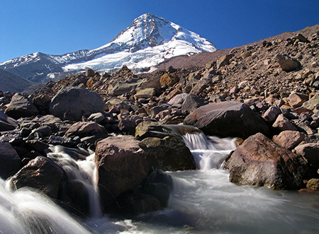
The Eliot Branch and Mount Hood
A few weeks ago the Forest Service contacted me about a recent article posted on this blog, It’s Time to Fix the Eliot Crossing!
The article proposed some simple solutions for restoring a washed-out section of the Timberline Trail at the Eliot Branch, which has been offically closed for nearly a decade, and is quite dangerous for those who choose to ignore the closure signs.
The article critiqued Forest Service inaction on the problem, and especially the agency obsession with the “million dollar bridge” solution of somehow installing a supension bridge over the disintegrating canyon of the Eliot Branch. This stream is the unruly outflow from the Mount Hood’s Eliot Glacier, largest of the mountain’s glaciers.

Crossing the Eliot Branch in better days on the old footbridge
The proposed susppension bridge would have been prohibitively expensive, and had little chance of ever being funded. Worse, any bridge built here stands a very good chance of being destroyed: the steady retreat of the Eliot Glacier will continue to unravel the canyon below for the foreseeable future as the Eliot Branch carves into new ground once covered by glacial ice.
Because of the critical nature of the article, I expected some grief from the Forest Service. Instead, I learned the Hood River Ranger District has now scrapped its “million dollar bridge” solution and is pursuing a simpler downstream crossing, very similar to what was proposed in the blog article. That’s great news!
The Hood River District staff invited me to meet with them and have a look at their new proposal, so I sat down with one of their Forest Service planners in late December to hear the details. The following are highlights from that conversation.
While they are still in the very early stages of laying out a route, the following map shows the general corridor (in green) the Forest Service has scouted for a “low trail” solution, compared to the new trail concept proposed in the earlier blog article (dashed red):
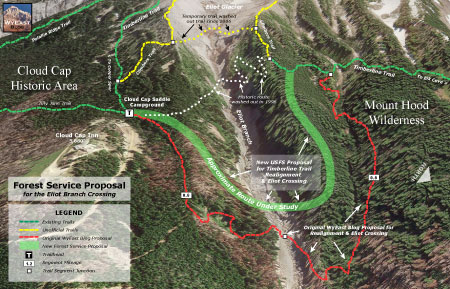
(Click here for a larger version)
The conceptual Forest Service route would descend the east wall of the Eliot Branch canyon in a series of short switchbacks, just upstream from the ravine where the route was proposed in the blog article.
Once across the Eliot Branch, the Forest Service route would traverse along the ridge that forms the west wall of the canyon, while the route proposed in the blog article followed a tributary stream up a ravine that leads to the Timberline Trail. The Forest Service route is a bit shorter, at 1.2 miles, but follows the same “keep it simple” principles laid out in the blog article.
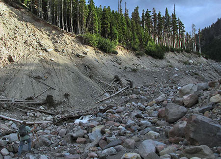
The Eliot Branch in the vicinity of the proposed crossing (photo © Tim Burke)
Here’s the best news: the Forest Service hopes to have the new trail under construction in 1-2 years, and have already begun scouting possible alignments. Even better, they hope to involve volunteers in some aspect of the construction, and have reached out to Trailkeepers of Oregon (TKO) to begin that conversation (note: the author is also active in TKO).
This has been a long time coming, and kudos are in order for the Hood River Ranger District for getting this project unstuck — and especially for new staff at the Hood River office who have been instrumental in putting the “million dollar bridge” fiasco behind us. While much more work lies ahead for this project to become a reality, it’s a promising change of direction and a new level of commitment from Forest Service to finally fix this problem.
I’ll post updates on the project here over the next couple of years as the details come into view, of course!
A Mea Culpa is in Order…
When I arrived at the Hood River Ranger District last December for the Timberline Trail meeting, I was surprised to see that the visitor facilities had been dramatically upgraded! This was to my chagrin, as I had lamented the need to do so in this blog article in early 2014. It turns out that the finishing touches to the remodeled Hood River offices were being made at about the time I posted those comments here, so a mea culpa is in order!
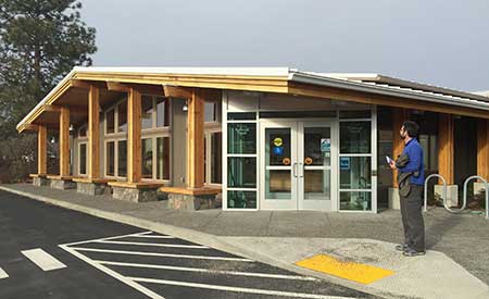
Like me, you probably won’t notice the changes to the Hood River Ranger Station when driving by on the Mount Hood Loop Highway, as the public face of the building has been redesigned to face south, not toward the highway to the east. In fact, the building looks much the same from the highway to the casual eye — though an addition to the main building, new signage and an outbuilding have been constructed in what was once a very large parking lot (see below).
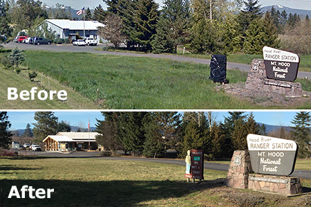
Before and after highway views of the ranger station
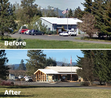
Before and after views of the ranger station
The new orientation makes perfect sense when you stand in front of the building, however. A picturesque view of Mount Hood rising above orchards fills the scene — a view echoed and embraced by the pyramid-shaped wall of windows that define the new visitor center.
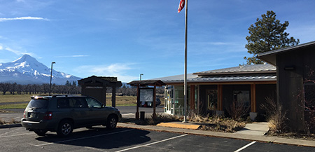
Mount Hood fills the southern horizon
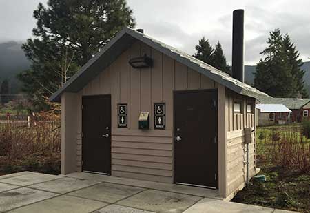
The revamped building exterior has ADA-compliant parking and ramps, a small plaza, updated informational sign kiosk, carved welcome sign, bike rack and a new pit toilet. The latter is a much-needed addition that is less elegant than the flush toilets provided at the new Zigzag Ranger Station, but still a nice step forward.
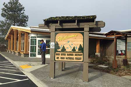
This carved sign welcomes visitors to the new facility
The new visitors center is ADA accessible
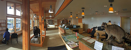
Once inside the new visitors center, you will find a main desk staffed by a Forest Service ranger, and a nice mix of interpretive displays, ranging from historical artifacts to a collection of mounted wildlife specimens found in the Mount Hood region. The center also has a very good selection of field guides and maps for sale, in addition to many free USFS informational materials.
A nice touch inside the building is a terrestrial telescope mounted on a tripod in front of one of the large picture windows, allowing visitors to take a closer look at the mountain that looms above the ranger station.
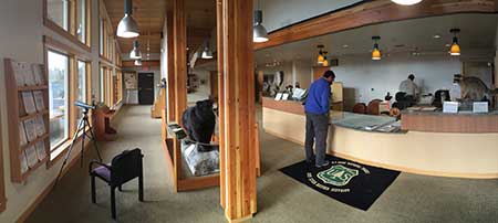
Interior panorama of the visitors center (note telescope on the left)
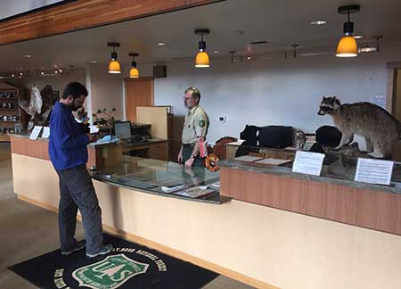
Rangers staff the new front desk at the visitors center
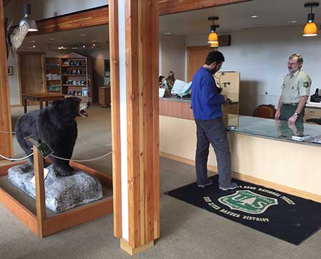
Watch out… bears lurk behind posts in the new facility!
The wildlife specimens will be fun and informative for families visiting the center, as kids are universally drawn to animal displays. Each mounted display has a detailed info card to help parents become instant experts on the different species represented, or for older kids (and adults) to simply browse and learn from.
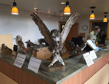
Owls on display at the front desk
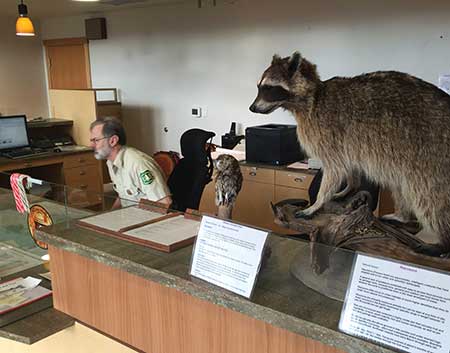
Guard raccoon is on duty 24/7…
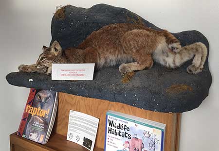
A particularly menacing bobcat is on display!
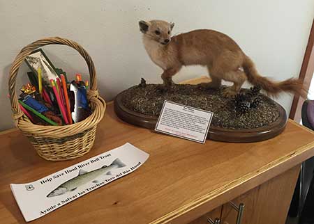
This Pine Marten is in charge of the Bull Trout bumper stickers…
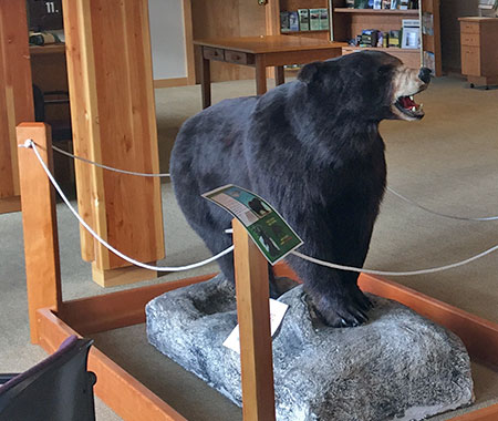
Black bear roaming near the front desk
The bookstore is located at the west end of the visitor center and creatively designed as a rolling, self-contained portable display. The book offerings are excellent, including many of the most popular regional hiking, climbing, skiing and snowshoeing guides, plus field guides to area flora, fauna and history. Posters and coffee-table books celebrating Mount Hood are also featured.
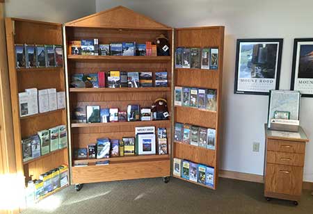
The rolling bookstore has an excellent cross-section of materials
The map offerings in the rolling bookstore are also excellent, including USFS maps for most National Forests in Oregon and Washington, and official Forest Service maps for wilderness areas in the more immediate Mount Hood region.
The map selection also includes several independently published trail and ski maps, including the exceptional National Geographic Trails Illustrated series for Mount Hood and the Gorge and maps for the Pacific Crest Trail. There are even Green Trails topographic maps for the Mount Hood region (below).
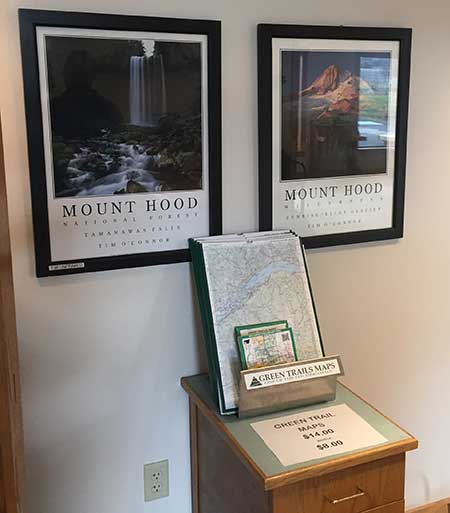
Green Trails topographic maps for sale
Historical interpretation is somewhat more limited at the new center, anchored by a fine carved sign (presumably Works Progress Administration or Civilian Conservation Corps?) that once stood at the Cloud Cap junction on the old loop highway. The impressive old sign is flanked with captioned photos of north side history on the mountain.
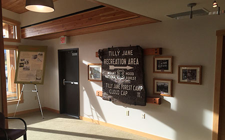
History displays at the west end of the new facility
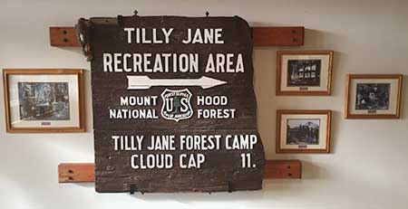
Historic Tilly Jane sign anchoring the history displays
A mounted poster from the Mount Hood Scenic Byway series provides a bit more history of the Cloud Cap Inn and the early climbing history of the north side.
Hopefully, new displays will be added over time to explore more of the rich history of the upper Hood River Valley and north side of Mount Hood: the long Native American history in the area, settlement of the upper Hood River Valley in the 1800s, early Forest Service history on Mount Hood and completion of the Mount Hood Loop Highway in the 1920s are just some of the stories that deserve to be told here.
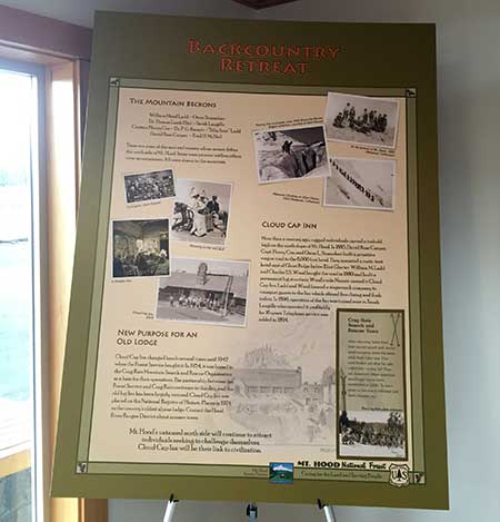
Mount Hood Scenic Byway history poster
There are still some gaps in the visitor experience at the revamped ranger station that could use some attention. First, heavy landscaping hides the Ranger Station from southbound highway traffic (which is how most visitors travel to the mountain), and the signage along the highway is easy to miss. Adding a simple “Visitors Center” sign to the existing entrance marker would be helpful.
Second, the visitor center hours posted at the door differ from what appears on the official Mount Hood Forest website. At least two variations appear on the website, depending where Google takes you: the main website listing shows a M-F schedule, while the dedicated Hood River Ranger District page includes Saturdays in the daily schedule.
The new center elegantly packs a lot into a modest space
The signs at the main entrance to the Ranger Station split the difference, showing M-F hours, but extending to include Saturdays from Memorial Day through Labor Day. In all of these variations, the actual hours are the same: from 8:00 AM to 4:30 PM, closed on all federal holidays.
Obviously, Saturday operating hours are at a premium, both for the Forest Service in covering their expense of keeping the building open, but also for visitors, who are more likely to be traveling here on weekends than weekdays.
Hopefully, the agency can someday find a way to keep the visitors center part of the Ranger Station open on Saturdays (and even Sundays?) year-round. Weekends are undeniably the busiest visitor time on the mountain, and Mount Hood is busy year-round.
Closed mornings, evenings and weekends..?
Finally, the pit toilets located outside the new visitor center are currently locked when the visitors center is closed — an unwelcome and unfortunate surprise for travelers who stop early or late in the day, or on weekends.
In the long term, a better way to address the mismatch between federal government hours and those when the public is most likely to be recreating (weekends and holidays) would be to expand the outside informational and interpretive displays to better serve visitors when the main building is closed. This could even include locating interpretive displays some near the pit toilets, and leaving them unlocked on weekends and holidays.
Despite these rough edges, the new visitor center really shines for the Hood River Ranger District. The new facility should greatly enhance the visitor experience for those seeing the area for the first time.
But even if you’re a seasoned Mount Hood hiker, the new center deserves a stop on your next trip through the area. Plan for 20-30 minutes to explore the displays and browse the books and maps.

Thanks for being proactive about this, Splinty. Even though my fantasy solution involved zip lines, this re-route is the best way to go. I scouted out the ridge crossing the FS is proposing back in 2008 and like it for the lack of ash-and-loose-scree walls that are unavoidable south of the new proposed crossing. Regaining the ridge west of the Eliot was dufficult without a trail, but that terrain is tamable.
LikeLike
That is great news, indeed! Glad they’re going to get a new route going and not spend a ton of money on it. Would love to help with the volunteer efforts, so keep us posted!
LikeLike
Congratulations. I really hope they start listening to you about some of the other things you’ve blogged about. Since you may have their ear, there is one other thing they are doing that bugs me. Maybe you might consider blogging about it or talking to them. That is they allow some of the campground concessionaires to charge parking fees at trailheads. It is legitimate at Lost Lake, since that is a private inholding, but it is not at Trillium Lake, which is supposed to take the passes just like other trailheads, but the concessionaire has posted a sign saying the NW Forest Pass and the Senior and Disabled passes are not good there, you have to pay $5 to them. I ignore the sign and dare them to do something about it, but they never have. Apparently, they didn’t look at the contract before they signed it, but I don’t think it is legal as the passes are governed by Federal law, and are supposed to be good at all trailheads.
LikeLike
Thanks for stopping by, Jon & Chase!
Ditto gebanks — I do have the outsourcing of our trailheads and campgrounds on the future articles list, including a “citation” that I proudly treasure, courtesy the Thousand Trails corporate vendor that operates many of the “contracts”. Totally offensive to the notion of public lands — I couldn’t agree more!
LikeLike