
Each year at about this time I assemble the Mount Hood National Park Scenic Calendar. The proceeds are modest, but do help support the Mount Hood National Park Campaign website, WyEast Blog and related project expenses. But the main purpose is to simply promote the national park concept, and make the case for the campaign with pictures.

What the calendar looks like – oversized 11×17” pages you can actually use!
I’ve published the calendars since 2004, so this year’s calendar marks the ninth edition. All of the photos in the calendar are from trips and trails I’ve explored over the past year. I get a surprising number of questions about the photos, so in addition to simply announcing the 2013 calendar, this article tells a bit of the story behind the new images — and some are surprising!
The 2013 Scenes
The cover image for the 2013 calendar is Upper McCord Creek Falls, located just west of Cascade Locks. This is a popular destination for Columbia Gorge lovers, though often overshadowed by its more famous downstream sibling, Elowah Falls.

Cover Scene: Upper McCord Creek Falls
Upper McCord Falls is unique in that it flows as a twin cascade. A little known fact is that a third segment used to flow during the rainy season as recently as the 1970s, just to the left of the two segments shown in the photo (above). The third segment has since been blocked by stream debris, however, so for now, Upper McCord is best known as a twin cascade.
The falls is popular with photographers, but in 2010 was briefly obstructed by a large treetop that had split from atop a nearby maple, landing perfectly on its head, directly in front of the falls. While the local photography community simply grumped and groaned about this unfortunate development, Gorge waterfall explorer and photographer Zach Forsyth did something about it: he scrambled down the slope, and neatly tipped the 40-foot up-ended tree on its side. Thus, Zach made this year’s calendar cover possible – thanks, Zach!

Upper McCord Creek Falls with “the stump” in 2010
Upper McCord Creek Falls is tucked away in the hidden upper canyon of McCord Creek, just a few hundred yards from the brink of Elowah Falls. The trail to the upper falls is especially spectacular, following a ledge chiseled into sheer cliffs in the early 1900s to pipe water to the former Warrendale Cannery, below (portions of the pipe system can be seen along the trail). The falls is hidden from view until you abruptly arrive at the dramatic overlook, directly in front of the falls – one of the finest and most unexpected scenes in the Gorge.
The January calendar scene is a wintery view of the rugged west face of Mount Hood, just emerging from the clouds after a fresh snowfall. This view was captured just a few weeks ago near Lolo Pass, as the evening light was briefly catching the summit.

January Scene: West face after an early winter storm
Like most “mountain in the mist” images, this one was a reward for patience: I waited for two chilly hours for the clouds to clear! It worth the wait, though I’ve also had my share of disappointments when that glorious glimpse of the mountain didn’t materialize.
For the month of February, I picked an image from a trip last winter along the Little Zigzag River. I had planned to snowshoe to Little Zigzag Falls from the Kiwanis Camp, but there were only about 18 inches of snow on the ground, much of it fluffy and new. So, I simply trudged through leaving some very deep boot prints in my wake — and happily, the only footprints on the trail that afternoon.

February Scene: Little Zigzag River in winter
The weather was extremely cold on this visit, revealing one of the surprising effects of running water in winter: it turns out the sheer volume of relatively “warm” water (that is, above freezing) flowing down the Little Zigzag river actually heats the narrow canyon, much like an old steam radiator heats a room.
Following this radiator analogy, the temperate gradient is most noticeable when air temperatures are really cold. It was about 12º F that day, yet the air right next to the stream, and especially in front of Little Zigzag Falls measured in at a “balmy” 30º F. I found myself peeling off layers while shooting the stream and falls, only to hurriedly put them back on as I ventured back down the trail and into the real cold!
For the month of March I chose another waterfall scene, this time the lush, verdant base of popular Latourell Falls in the Columbia Gorge.

March Scene: Latourell Falls in spring
On this visit to the falls, Oregon State Parks construction crews were starting work on several major upgrades to viewpoints along this busy trail. As a result, the most popular trailhead at the Latourell Wayside was closed. Instead, I took a back route to the falls and had the place to myself for the better part of an hour — nearly unheard of on what should have been a busy spring weekend at Latourell Falls.
The April calendar scene is from Rowena Plateau at the McCall Preserve, in the dry, eastern Columbia Gorge. The iconic yellow balsamroot and blue lupine were in peak bloom on this sunny afternoon in mid-spring, and the glassy surface of the Columbia River in the background reveals a rare day of calm in the normally windy Gorge. The very tip of Mount Adams peeks over the hills on the horizon, on the Washington side of the river:

April Scene: Balsamroom and lupine on Rowena Plateau
The trip to Rowena was especially memorable for me, as I was hiking with an old college friend who was visiting Oregon for a few days. Rowena was a great place to catch up on news and old memories.
My friend also happens to be an eminent geologist working for the federal government, so we had a great conversation about the mystery of “desert mounds” (also known as “biscuit scablands”), which found on Rowena Plateau and in other areas in the Columbia Basin (watch for a future WyEast Blog article on this subject…).

Hikers passing one of the mysterious desert mounds on Rowena Plateau
Continuing the balsamroot-and-lupine theme, the May scene in the new calendar comes from Hood River Mountain, a tract of private land that is (for now) open to the public, but at risk of closure, due to heavy use by hikers.
This is one piece of land that will hopefully come into public ownership someday, before a less responsible private owner places trophy homes on these beautiful slopes. I wrote about this unfortunate oversight in the Columbia River Gorge Scenic Act in this article from a few years ago.

May Scene: Hood River Mountain in May
On Memorial Day last spring, I made a trip to Dry Creek Falls, a beautiful waterfall saddled with one of the most unfortunate and uninspiring place names in the Gorge! The June calendar image is from that trip, and captures Dry Creek rambling through the forest a few hundred yards below the falls.

June Scene: (not so) Dry Creek in spring
This area has a unique history: an old, derelict diversion dam and waterworks survives at the base of the falls, where the City of Cascade Locks once tapped the stream for municipal water in decades past. Perhaps this is the origin of “Dry Creek” name — did the stream below the diversion actually go dry when the dam was installed? Perhaps, but today it flows year-round, and makes for a beautiful streamside hike in spring.

Dry Creek Falls and the remains of the old diversion dam and waterworks
The July scene in the 2013 calendar is from a trip to Elk Cove last August. This is one of my annual pilgrimages, and I have photographed this particular spot just east of Cove Creek too many times to count — yet I’m always excited to get there, and recapture the stunning scene.

July Scene: Summer wildflowers at Elk Cove
The wildflower bloom on Mount Hood was delayed by several weeks this year, so even though I was a bit late in visiting Elk Cove, there was still a bumper-crop of purple aster mixing with the blue lupine and mop-heads of western anemone, or Old Man of the Mountain.
Not visible in the calendar view of Elk Cove are the blackened forests directly behind me: the Dollar Fire of 2011 swept across a 5-mile swath along the northern foot of Mount Hood, charring the northern fringes of Elk Cove, including several large stands of mountain hemlock that frame the view from 99 Ridge.

The Dollar Fire burned a 5-mile swath across the north slope Mount Hood
Though it’s initially shocking to see healthy forests killed by fire, it is also part of the natural cycle of forest renewal. Thus, we’ll now have a front-row seat to the fire recovery process that will unfold over the coming years along the popular north side trails. I wrote this blog article on the Dollar Fire earlier this year.
For the August calendar image, I picked a less familiar scene from an otherwise popular hike: the soaring trail to the 8,514’ summit of Cooper Spur. To beat the crowds, I set my alarm for 3 AM and raced to the trailhead at Cloud Cap. I was the first to arrive at the string of dramatic viewpoints along the trail, and caught the first rays of sun lighting up the northeast face of the mountain.

August Scene: Eliot Glacier from Cooper Spur
This view is from the north shoulder of Cooper Spur, just below the summit, and looking into the impressive jumble of crevasses and icefalls along the Eliot Glacier. Though the sky was crystal clear (you can see the moon setting to the left of the mountain), the winds from the south were strong and blustery. So, getting this shot from the lee side of the spur also meant enjoying some respite from the intense wind and blowing volcanic grit.
For the September image, I selected a lesser-known view of the mountain: the remote and rugged Newton Canyon, on the southeast side, where Mount Hood has a broad, massive profile.

September Scene: Rugged Newton Creek Canyon on the east side of Mount Hood
Glacial Newton Creek is best known for the havoc it brings far below, where the stream has repeatedly washed out Highway 35 with violent debris flows that toss Toyota-size boulders and whole trees across the road in their wake. Construction crews were busy this summer completing yet another repair, this time for damage that occurred in the 2006 floods. As always, the new road is bigger and higher than the old. We’ll see if Newton Creek is persuaded to flow through the new series of larger flood culverts this time…
The October scene is from Wahclella Falls on Tanner Creek, a popular family hike that also provides terrific viewing of spawning salmon and steelhead in early autumn.

October Scene: Wahclella Falls in autumn
Fall colors were somewhat muted in 2012, thanks to an unusually long, dry summer that extended well into October. As a result, the broadleaf trees in many areas had already dropped a lot of leaves due to the stress of the drought, before they would even have a change to change with the seasons.
While fall colors at Tanner Creek were less affected by the summer drought, the autumn scene in this year’s calendar has to make due without without the help of the particular tree, the Wahclella Maple I wrote about earlier this year. You can see the hole it left by comparing this year’s image (above) and a 2010 image (below).

Wahclella Falls in 2010 with the Wahclella Maple still standing above the footbridge
Since 2007, I’ve made annual trips with friends and volunteers to tend to the Old Vista Ridge Trail on the north side of Mount Hood. This historic gem from the early 1900s was an overgrown, forgotten victim of the Forest Service clear-cutting juggernaut for some 40 years, but somehow managed to escape their chainsaws.
Volunteers re-opened the Old Vista Ridge Trail in 2007, spurred in part by a Forest Service scheme to turn the area into a playground for dirt bikes and ATVs — an appalling plan that was eventually abandoned, in part because the rediscovered trail had revealed the beauty of the area to so many.
In 2010, the trail became the official northern boundary of the expanded Mount Hood Wilderness, when President Obama signed a new wilderness bill into law. This change should close the door on future Forest Service threats to the area, and today the hike into one of the best on the mountain.

November Scene: Mount Hood from Owl Point
The November calendar scene is from a viewpoint along the Old Vista Ridge Trail known as Owl Point, the rocky outcrop with stunning views of the mountain. Bright red huckleberries light up the foreground in this scene, and the first dusting of snow highlights the mountain. In the distance, you can also pick out the browned forests on the slopes of Mount Hood, where the Dollar Fire swept across the base of the mountain in 2011.
The final image in the new calendar is another taken from Lolo Pass, perhaps one of the most spectacular views of Mount Hood. This image was taken just before sundown after a fresh snowfall had blanketed the mountain.

December Scene: Winter arrives at Lolo Pass
I paid the price for taking in the sunset that night at Lolo Pass, as my car was broken into at the trailhead – something I’d somehow managed to avoid in all my years of hiking! As frustrating as it was to deal with the repairs and lost belongings… I’d do it all over again just to spend those magical hours watching the mountain that night — it was truly breathtaking! Here, take a closer look, and see for yourself:
Mount Hood from Lolo Pass | 2012
_________________
The thirteen images I chose for the 2013 calendar are from a few thousand images I’ve taken this year on something just shy of 40 outings to Mount Hood and the Gorge — a bit less time on the trail than a typical year would allow, but no complaints! As always, these adventures took me to new places and discoveries, as well as fond visits to my favorite old haunts.
And as always, the magnificent scenery further confirmed my conviction that Mount Hood should (and will!) be set aside as our next National Park! Hopefully, the calendar makes the case, as well.
How can you get one, you ask?
The new calendars are available online:
2013 Mount Hood National Park Calendar at CafePress
They are large and functional, measuring 17” across by 22” tall when hung, with plenty of room for writing notes and scheduling activities. CafePress packages them carefully, with each calendar sealed against a corrugated cardboard backing for support.
The calendars sell for $29.99 + shipping, with about 25% of the proceeds going to support the Mount Hood National Park Campaign. They make terrific stocking stuffers (…although you’ll need an 11×17” stocking…), and CafePress now makes it even easier by offering PayPal as an option.
And as always, thanks for your support!
_______________________________________
Addendum: Gorge uber-Guru Scott Cook set me straight on a couple of comments in the above article:
Hey Tom, so of course I read your blog like a good Gorge denizen. A couple of points…I’m not trying to sound like a know-it-all…but I know that you do like to get at the bottom of things and eschew conjecture:
The pipes visible on the Upper McCord trail are from Myron Kelly’s pulp mill, not Warren’s cannery. There are some pix on my blog of Kelly’s mill and iterations of his pipes. I have another old pic too showing the pipe running along the cliff cleft, illustrating to me that the cleft was a pipeway instead of a WPA/CCC construction.
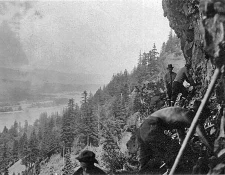
(author’s note: here’s a photo I shared with Scott that shows CCC crews clearing out the old waterline shelf to make way for the trail to Upper McCord Falls — note the Historic Columbia River Highway, far below, and the CCC crew bosses in full uniform)
…and, about Dry Creek falls, the Creek was called Dry Creek before the water works were installed. The reason is that just downstream of the PCT trail bridge, just down the access road 200yards, the creek dries up in the summer to nothing, just a dry creek bed as the creek goes subterranean until re-emerging downstream of the powerline corridor.
If you walk down the access road in the summer, the stream is of course flowing under the bridge, but when you walk downstream the sound goes away and you just figure the stream curved away from the road, but nope, if you bushwhack over just 100 feet you’ll see the dry stream…as you will if you continue down the access road also.
Down the (Dry Creek) access road is a bunker-looking building that was built in the 30’s to store the water from the stream’s waterworks for the city’s first municipal supply. The water shed is still in use today, but the water is pumped upwards into it from wells in the town below.
Next edition of Curious I’ll have Dry Creek Falls as a loop using the powerline access road…so people can learn the history and see the Dried-up Creek as well (cuz everyone loves a loop). Look for my pix on Google Earth of all this stuff and the dried-up creek. -Scott
Thanks, Scott!

Beautiful pics and project, Tom. Love the January shot. Would you share where you took that from or is that a secret spot?
LikeLike
No secret at all, Jon — it’s from Lolo Pass Road about 1/4 mile east of the pass, as you descend toward Elk Creek. Thanks for stopping by!
LikeLike