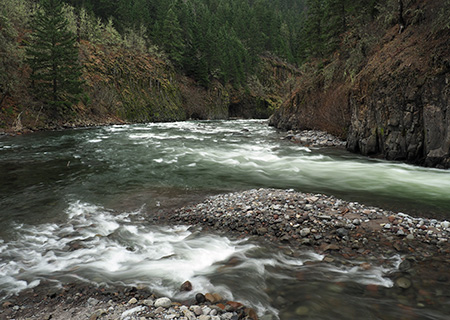
Dollar Lake Fire: Five Years After

dollarfirefiveyears01

The Dollar Lake Fire from Bald Butte in August 2011

In 2006, the Bluegrass Fire raced along Bluegrass Ridge, torching the subalpine forests above Elk Meadows on Mount Hood’s east flank. In 2008, the Gnarl Fire burned a much larger swath of the east slope, from just above Elk Meadows to the Eliot Branch canyon, nearly destroying century-old Cloud Cap Inn, Snowshoe Lodge and the historic structures at nearby Tilly Jane Campground. Heroic efforts by Forest Service firefighters spared these priceless jewels of Mount Hood’s history, with the fire burning within a few yards of these old structures.

In August 2011, the Dollar Lake Fire was the third in a string of major fires that would ravage the slopes of Mount Hood in a period of just five years, this time burning the north slopes of the mountain. Lightning started the Dollar Fire started on a weekend, just below the popular Elk Cove trail and was immediately reported by hikers in the area.
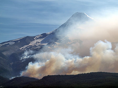
dollarfirefiveyears02

The Dollar Lake Fire burning below Elk Cove

The Dollar Fire soon erupted to become one of the most fiercely fought and carefully documented fires in recent memory as it swept to the west, eventually threatening Bonneville Power Administration transmission lines at Lolo Pass and the nearby Bull Run Watershed, source of Portland’s drinking water.

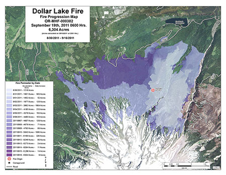
The fire wasn’t fully contained until the end of September of that year, eventually burning more than 6,200 acres of forest (maps and photos of the fire can still be viewed on the InciWeb interagency website).

dollarfirefiveyears03

Flare-up in the Dollar Lake Fire in August 2011

Firefighting efforts were initially slow to arrive at the Dollar Fire, and some (including the media and members of Oregon’s Congressional delegation) accused the Forest Service of purposely allowing the fire to grow because it was inside the Mount Hood Wilderness where it didn’t threaten areas open to commercial logging. But a subsequent investigation pointed to overstretched firefighting resources, a growing problem as the federal land agencies struggle to fund the spiraling forest fire phenomena across the west.
dollarfirefiveyears04

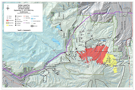
Location of the Dollar Lake and Gnarl fires

 [click here for a large map]

By the time fall rains arrived, the fire had burned almost the entire north slope of Mount Hood, a 5-mile swath stretching from the Eliot Branch on the east to Cathedral Ridge on the west. Almost all of the burn was subalpine Noble fir forest, though a few old-growth mountain hemlock stands along the Timberline Trail were burned at Elk Cove and Cairn Basin.
dollarfirefiveyears05

Timeline and extent of the Dollar Lake fire

[click here for a large map]

The eastern extent of the Dollar Burn contained large stands of Western larch, a fire forest species adapted to frequent, low intensity fires. Most of these trees did not appear to survive the fire, however, due to its extreme heat and intensity.
dollarfirefiveyears06

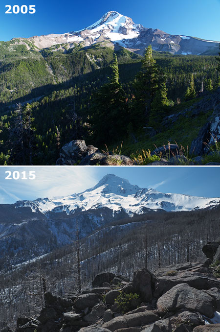
Ground zero for the Dollar Lake fire is the foreground in these views from the Elk Cove Trail taken before the burn and five years after the fire

 [click here for a large map]

In fact, very few trees survived the fire except along its margins, where a beneficial mosaic burn pattern left standing trees and some undergrowth to help begin the recovery phase. This is the new reality facing our forests, as a century of fire suppression continues to fuel catastrophic fires that completely destroy forest on a massive scale.

Summer 2012: Immediate Aftermath

dollarfirefiveyears07

Total destruction along Vista Ridge in 2012

The dense network of trails that cross through the Dollar Burn provide a front-row seat to how (and if) our forests recover from catastrophic fires inside a protected wilderness, without human intervention. In the immediate aftermath of the Dollar Fire, the picture was bleak. In the heart of the burn, the forest kill was nearly complete, as even the duff layer on the forest floor was burned away, exposing a thin layer of volcanic soils vulnerable to erosion.
dollarfirefiveyears08

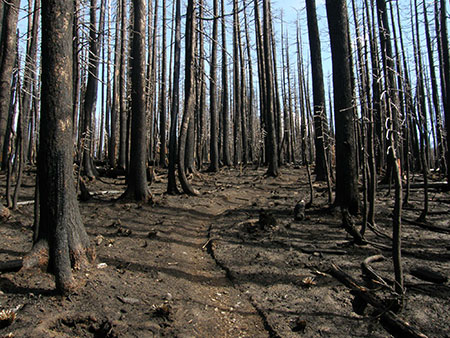
Blackened trees in 2012, before scorched bark began to peel away

One of the first lessons of the fire was the importance of tree debris in stabilizing the unprotected soil. The living trees in this forest weren’t burned so much as boiled alive as their living cambium layer was superheated beneath their bark. The surprising result in the first season after the fire was scorched bark peeling away to reveal untouched wood underneath.

The piles of peeled bark provided an immediate layer of mulch over the exposed soil, with smaller twigs and limbs also helping to form the beginnings of a new duff layer on the burnt soil.

dollarfirefiveyears09

Trees inside the burn shed their scorched bark in the first year, helping stabilize exposed soils

The roots of some understory plants in the worst of the burn zone also survived the fire, including huckleberry, beargrass and avalanche lilies. Two years after the fire, seeds blown into the burn began to establish, and the recovery was underway in surprisingly short order. Read more about the initial recovery in this 2012 WyEast Blog article.

2016: Five Years of Recovery

This year marks the five-year anniversary of the fire, and the recovery within the Dollar Burn is in full swing, though it will take a century or more for the area to fully recover – more on that in a moment.

How does the Dollar Burn of today compare to the first summer after the fire? As the July scenes along the Vista Ridge Trail (below) show, the understory is recovering rapidly.

dollarfirefiveyears10

Comparison of the recovery along the Vista Ridge Trail in 2012 and 2016

In 2012, avalanche lilies sprung from bulbs spared by the heat of the fire, creating striking stripes of white blossoms and bright green foliage where these plants survived. A few beargrass (a close relative of the lily family) also survived, thanks to deep underground roots that escaped the fire. A few scattered huckleberry and other understory shrubs also sprouted from surviving roots in the first summer after the fire.

In recent years, the beargrass and avalanche lily display in the Dollar Burn has become a spectacular attraction for early season hikers on the Vista Rigde Trail as these fire survivors continue flourish and spread in the bright new conditions. Other shrubby survivors, like huckleberry, have also continued to recover, thriving in the bright new conditions created by the fire.

But the story in the last few years of the recovery has been the arrival of new plants in the burn zone, blown in by seed or deposited by wildlife. These include more understory species, but also the first few conifers to take root.
dollarfirefiveyears11

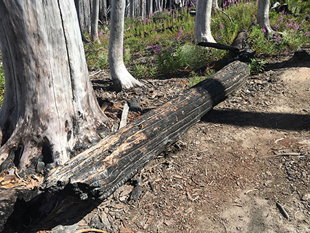
This trailside log was a favorite resting spot for hikers on the Vista Ridge Trail before the Dollar Fire. Since the fire, hikers still rest here and have begun to polish away the charred surface along the top of the log – presumably with a charcoal backside as their souvenir!

After five years, most of the scorched bark has fallen from the torched trees, and the trunks underneath have bleached from their initial golden shades of newly exposed wood to weathered silver and gray shades of a “ghost forest”.

The standing ghost trees still retain a surprising number of their limbs, and perhaps more surprising, very few have toppled in the five years since the fire. This is testament to the fact that the core of these trees didn’t burn. Most will stand for decades before insects and decay finally bring them down.
dollarfirefiveyears12

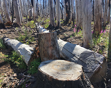
These felled Noble fir along Vista Ridge Trail reveal a forest that was more than 300 years old before the fire

A few trees in the burn zone were cut by firefighters in an attempt to create fire lines. Today, these cut stumps provide a look at the age of this forest. While the trees in the Dollar Burn aren’t particularly large by Pacific Northwest standards, they were actually quite old. The cut tree shown above was more than 300 years old and stump below is from a tree that had grown on Vista Ridge for 360 years!
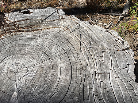
dollarfirefiveyears13_360years

This ancient Noble fir was 360 years old when it succumbed to the catastrophic Dollar Lake fire

The extreme weather conditions and thin soils make for a hard life for subalpine trees, stunting their relative size compared to lower-elevation forests.

The relatively modest size of these trees compared to their impressive age is another reminder of the vulnerability of our subalpine Noble fir forests that are still being logged commercially. While they continue to be “harvested” in unprotected areas under the premise of sustainability, these trees take centuries to reach a size worthy of commercial cutting, making the “harvest” more like mining than tree farming.

The Pioneers
dollarfirefiveyears14

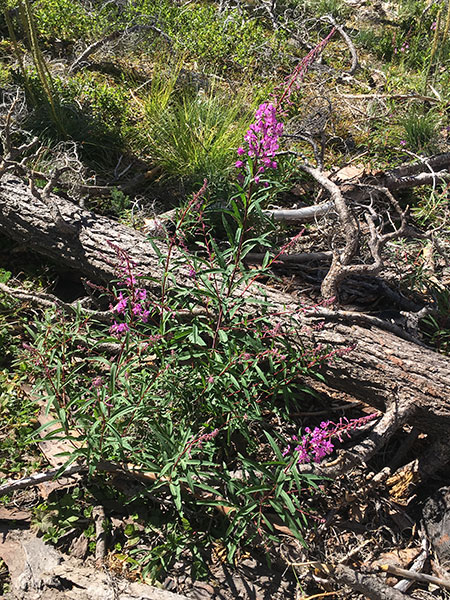
Fireweed is the rock star of the pioneer plants species in the burn zone

The understory in the Dollar Burn is noticeably greener just five years after the fire, and a closer look reveals a handful of plant species doing the heavy lifting at this stage in the forest recovery. At the top of the list of pioneer species is fireweed, (described here in the previous article in this blog).

dollarfirefiveyears15

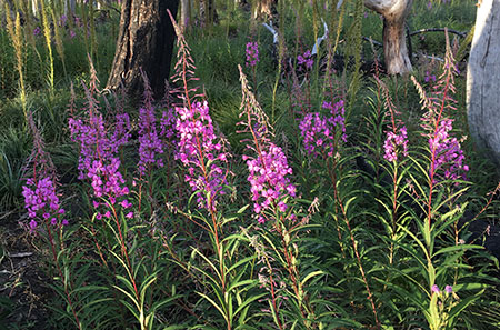
Fireweed crowding the Vista Ridge Trail in 2016

True to its name, fireweed has evolved to be the first in line to resettle burned or disturbed areas. These plants produce massive quantities of winged seeds that can quickly reach very large areas. They are also hardy perennials with large root systems, so also play an important role in stabilizing exposed soil.

In the Dollar Burn, fireweed has already colonized large areas, creating a spectacular flower displays from mid-summer through fall.

dollarfirefiveyears16

Showy blooms of Fireweed in late summer on Vista Ridge

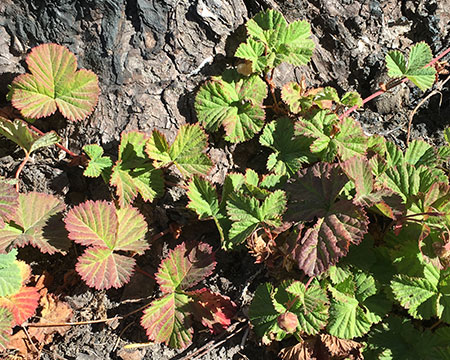
Look between the drifts of fireweed and you’ll find other pioneers taking root. One surprising species is the diminutive wild dwarf bramble (sometimes called wild strawberry for its resemblance of its runners and leaves to domestic strawberries). These tiny plants are now found throughout the burn, threading through piles of bark and limbs.
dollarfirefiveyears17

Wild dwarf bramble growing over charred bark along the Vista Ridge Trail

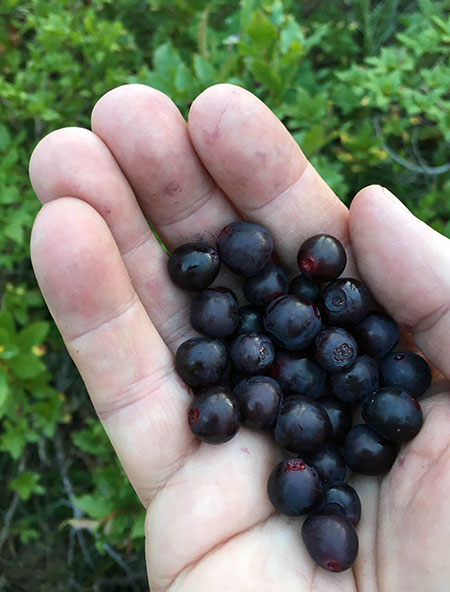
Huckleberries also continue their comeback, mostly from the surviving roots of established plants that grew before the fire but also as seedlings. In a few spots, the understory was not completely destroyed, and in these areas huckleberry is responding strongly to the bright conditions with abundant berry production.

dollarfirefiveyears18

Huckleberry seedlings emerging on Vista Ridge

dollarfirefiveyears19

Huckleberry seedlings growing from the base of a burned snag on Vista Ridge
dollarfirefiveyears20

Huckleberries that survived the fire are producing abundant berry crops in the suddenly sunny environment in the Dollar Burn

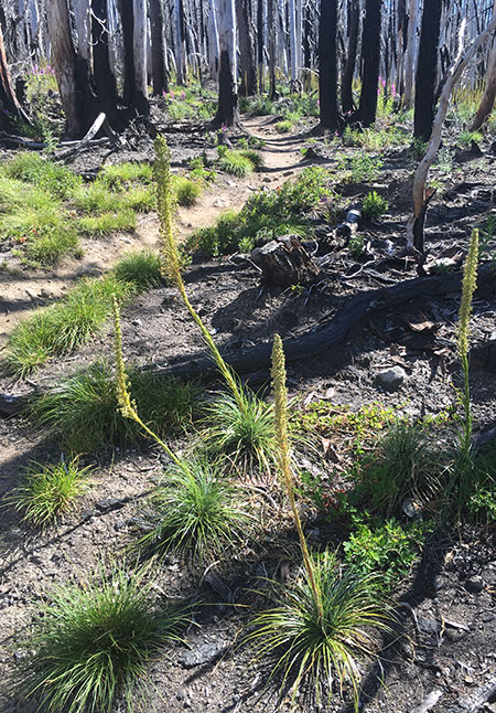
Though they were among the few understory survivors, the recovery of beargrass has been more gradual than expected. Most plants seem to be growing from roots that survived the fire, though the first big bloom of these survivors (and the seeds they produced) only arrived over the past two years.
dollarfirefiveyears21

Beargrass emerging from surviving roots are just beginning to produce blooms within the burn zone

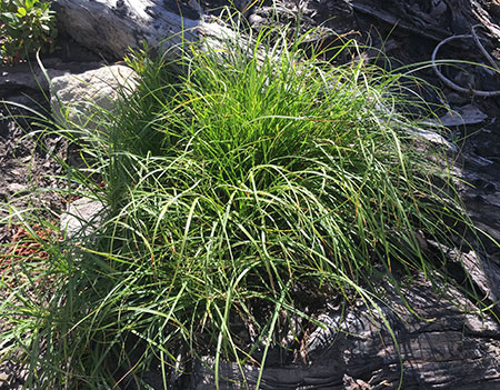
Clumping grasses have also arrived throughout the burn, as well as the occasional rush in moist, protected pockets.

dollarfirefiveyears22

Rush growing in a moist hollow on Vista Ridge
dollarfirefiveyears23

Clumping grasses are taking root in some of the driest areas of the Dollar Burn

Elderberry is among the few woody understory pioneers to arrive in this stage of the Dollar Burn recovery. These plants are scattered widely, growing in less burned areas, and may also be growing from surviving roots.

dollarfirefiveyears24

This young Elderberry shrub is just getting started in the burn zone in 2016

Conifers are just getting started five years after the Dollar Fire. Almost all of the conifer seedlings at this point in the recovery are Mountain hemlock and Noble fir, the dominant evergreens in Mount Hood’s subalpine forests.

By counting branch tiers, a few young trees as old as four years can be found, but most are one or two year-old seedlings. But if you look closely, there are also many seedlings that have not survived the harsh summers in the burn zone, where there is little shade and the sandy mountain soils are extremely dry by the time rain reappears in the fall.

This is the sorting process at work, where only a few seedlings will survive winter cold, summer heat and competition from understory plants to someday become part of the new forest canopy.

dollarfirefiveyears25

Young Mountain hemlock in the Dollar Burn in 2016

dollarfirefiveyears26

Three-year old Noble Fir in the Dollar Burn in 2016

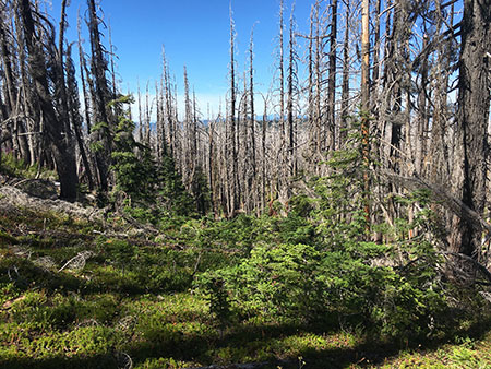
Though most of the Dollar Fire was an overheated catastrophe for the forest, killing almost everything, there are a few spots where the fire cooled and burned in a “mosaic” pattern, leaving a few surviving trees and much of the understory.

These areas are lush islands of life just five years after the fire, underscoring their importance in the recovery and why cooler mosaic burns can be beneficial to the long-term health of a forest. Pioneer species are much more abundant in heavily burned areas that are immediately adjacent to these surviving patches than in other parts of the burn, as plants quickly spread from these islands of green.
dollarfirefiveyears27

Island of green where the Dollar Lake Fire spared a section of forest that now serves as a nursery for regenerating the burn zone

While the Dollar Burn is recovering at nature’s pace, without human intervention, the Forest Service has given the nearby Gnarl Burn section along Cloud Cap Road a recovery boost by planting conifer seedlings. These trees were planting in 2010, about a year before the Dollar Lake Fire and following commercial removal of burned trees along the historic road.

dollarfirefiveyears28

Planted conifers in the Gnarl Burn along Cloud Cap Road in 2016

Today, these trees are thriving, and the main effect of replanting is the diversity of species, including lodgepole pine, western larch, Western white pine, Englemann Spruce and even whitebark pine at higher elevations. Noble fir and mountain hemlock do not seem to have been part of the replanting, perhaps because these species are the most likely to recover without human intervention.

The Long View?
dollarfirefiveyears29

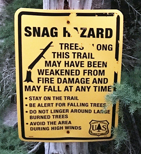
Hazard tree warning at the Vista Ridge trailhead

Hikers on the north side of Mount Hood will continue to have a front-row seat to the forest recovery in the Dollar Burn. Already, there are some surprising lessons.

First, the main victims of blowdown since the fire have often been the few trees that survived the fire intact. This is because of the sudden exposure of their canopy to winter winds and snow loads, and is a surprising blow to the forest recovery these trees would otherwise be helping to seed the burn zone.

dollarfirefiveyears30

Toppled surviving Noble fir in the burn zone in 2016

dollarfirefiveyears31

A surviving canopy becomes a liability in a burned forest, as surviving trees along Vista Ridge were tipped by winter storms in 2016

The Dollar Burn generally stayed well below timberline (and the Timberline Trail), leaving most of the alpine zone intact. But where the fire did burn into places like Elk Cove, Eden Park and Cairn Basin, we will also have an opportunity to watch how alpine ecosystems react to fire.

Some of Mount Hood’s most ancient forests grow in this zone, and have presumably survived because they are somewhat isolated from lower-elevation forests and often grow in moister conditions where snowpack is greater and summer days are cooler. But the forest could take centuries to recover in these areas, impacting the many species of plants and wildlife that live exclusively at this elevation.
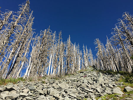
dollarfirefiveyears32

It could take centuries for this high-elevation forest of Mountain hemlock and Whitebark pine on Vista Ridge to recover from the fire

In human terms, it’s hard to see forest fire cycles in perspective, but in the case of the Dollar Burn, we have the benefit of early photographs from the area. Forest surveys show that the Red Hill area on the north edge of the Mount Hood Wilderness burned in the early 1900s, and were barely recovering by the 1950s (see below).

dollarfirefiveyears33

The view from Owl Point in 1952 and 2016 shows the cycle of fire on Mount Hood’s north slope over the past century (top photo courtesy Hood River History Museum)

[Click here for a larger version]

Today, the forest in this northern edge of the wilderness has substantially recovered after a century of regrowth, and now the view is reversed: the silvery ghost forests of the Dollar Fire now mark the once-green slopes of Mount Hood as viewed from Owl Point, while green forests and beargrass meadows cover the former Red Hill burn in the foreground.

dollarfirefiveyears34

Looking down on the Dollar Burn and Owl Point in the distance from the Timberline Trail in 2016

So far, so good, but the larger question in an era of climate change is whether our forests will continue to recover from catastrophic fire – or logging – in the way that we have always assumed they will.

As the recovery unfolds in the Dollar Lake, Gnarl and Blue Ridge burns on Mount Hood we’ll learn how resilient our forests really are, and hopefully make better decisions in protecting them for the benefit of future generations.
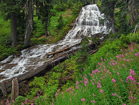
Fireweed: a rose by any other name..?

Fireweed01

Fireweed frames Umbrella Falls on the East Fork Hood River

Somewhere in the long history of botanical naming slander was committed, as the common name “Fireweed” was given to one of the most beautiful and useful plants found in our forests – and around the world. Thus, the noble Fireweed (Chamerion angustifolium) comes to be associated with notoriously invasive plants like Horseweed, Bindweed, Chickweed, Tumbleweed and Pigweed!

But Fireweed is anything but a weed, at least by the most common definitions:

weed  (wēd) noun

A plant considered undesirable, unattractive, or troublesome, especially one that grows where it is not wanted and often grows or spreads fast or takes the place of desired plants.

To the contrary, Fireweed is a widespread native in northern latitudes, growing from sea level to timberline in a remarkable range of habitats. The common name is half-right, as Fireweed is among the first and most prolific plants to return to burned areas, performing an essential role in stabilizing soil and providing shade for other flora to gradually return. Fireweed is equally at home in moist meadows, forest margins and wherever the ground has been disturbed by human or natural activity.

Fireweed02

Fireweed has carpeted the 2011 Dollar Fire on the north slopes of Mount Hood

The string of fires over the past decade on the east and north slopes of Mount Hood have brought a sea of brilliant Fireweed blossoms to the mountain each summer. Fireweed spreads readily by seed, but are hardy perennials, so they provide years of soil stabilization once established in burned forests or disturbed areas.

Fireweed blossoms are spectacular: their spikes can grow as tall as six feet, though typically they are 3-4 feet in height. Their flowering plumes can have 50 or more blossoms, opening first at the base of the spike and progressing through their long blooming season, typically from June to September.

Fireweed03

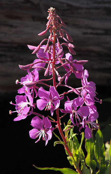
Fireweed flower spike

Each Fireweed blossom has four petals that alternate with four narrow sepals, surrounding white stamen and a pistil that splits in fourths.

Depending on your eyes, the blossoms are anything from hot pink to bright fuchsia. The flower stems are often bright crimson, as well, adding to the striking appearance of these plants during their bloom season.

Fireweed04

Fireweed flower spike

The leaves on Fireweed long, narrow strips, radiating from the stem like steps on a ladder. Their leaves give the Fireweed its Latin name of “angustifolium” (meaning narrow-leaved). A close look at the leaves reveals an unusual feature: circular veins looping back to the leaf stem instead of terminating at the edges like most plants.

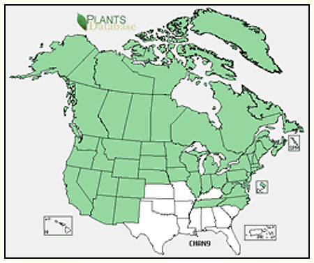
Given their adaptability to the wide range of habitats we have in Oregon, it’s not surprising that Fireweed is found across much of North America, as well as northern Europe:

Fireweed05

Fireweed is especially common in the boreal snow forests of Alaska and Canada, where the provincial flag of the Yukon Territory incorporates the Fireweed blossom:

Fireweed06

While Fireweed has an important ecological role as a pioneer species in burned areas, it was also collected by native peoples in the Northwest for a variety of human uses. Its leaves were brewed to make tea, and nutrient-rich spring shoots were collected as edible greens. Even the fluffy silk from its seed pods were used for weaving.

Today, Fireweed honey and other products from its nectar are still made where the flower is in abundance in places like Alaska, Canada and Northern Europe.

Fireweed Life Cycle

Fireweed07

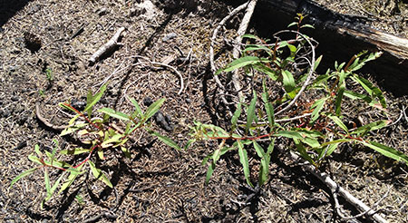
Young Fireweed patch in a recently burned area

Fireweed is a perennial species with the spirit of an annual. While it springs to life from hardy roots and stems each spring, Fireweed grows as easily from its abundant seeds as any annual species, and thus its ability to quickly colonize burned or disturbed areas.

Young plants often produce one large flower spike and a couple of small spikes from auxiliary buds along the main stem. The young Fireweed shown in the photo above are typical, with young plants growing in a dense patch, each producing one main flower spike.

As Fireweed plants continue to grow over successive seasons, they form multiple branches, each with one or more large flower spike. In this way, a single mature plant is eventually capable of producing dozens of spikes. The image below shows a larger, mature Fireweed with several large flower clusters growing from the main plant.

Fireweed08

Mature Fireweed with multiple stems

Just as the blossoms of Fireweed open progressively beginning from the base of the flower spikes toward, older blossoms soon produce elongated pink seed capsules (below) even as the tip of the flower spike is still producing blossoms.

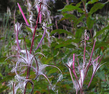
Within each capsule, seeds are attached to a fluff of silk that acts as a tiny parachute to carry them far and wide when the capsule splits open. This is the secret to the Fireweed’s remarkable ability to colonize.

A single Fireweed plant can produce 300 to 400 seeds per capsule and as many as 80,000 seeds per plant that will float as far as the wind will take them. Seeds can persist in the soil for years and survive fire, further helping the plant function as a pioneer species in burned areas.

Fireweed09

Fireweed seed capsules opening to reveal silk seed parachutes (USDA)

Fireweed seedlings quickly grow to form their first flower spike and produce seeds by their second year, while also establishing rhizomes that allow mature plants to spread and form clumps.

The first seedlings in a burn often take root where fire debris provides protection and mulch, with new plants quickly filling in the gaps in the first years after a fire. First year Fireweed seedlings look like this:

Fireweed10

First year Fireweed seedlings

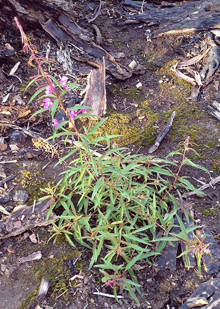
This two-year old seedling is coming into its prime in a still scorched area of the Dollar Fire burn, along the Vista Ridge trail:

Fireweed11

Second-year Fireweed with a main flower spike and several auxiliary spikes

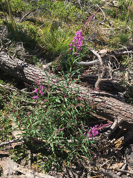
This more mature Fireweed plant has begun to spread its rhizomes and form a clump as it sends up multiple flower spikes in a protected spot by a fallen tree:

Fireweed12

Mature Fireweed

Adding to their colorful display, Fireweed leaves often turn to blazing shades of red and crimson in autumn, another showy feature of this remarkable plant:

Fireweed13

Fireweed foliage in autumn shades of red (USDA)

At higher elevations, the perennial stems of Fireweed are flattened by winter snowpack, but can survive the winter cold to produce broader clumps when new growth emerges in the next growing season.

What’s in a name?

With all of its beauty, versatility and ecological function, why isn’t the Fireweed more celebrated – outside of the Yukon Territory, that is?

Oh, be some other name! What’s in a name? That which we call a rose by any other name would smell as sweet…”

(Juliet Capulet, upon seeing her first Fireweed..?)

 One reason might be its humble name, so one option would be to revert to the British name of “Rosebay Willowherb”, a common name with origins in its herbal use dating to the late 1500s.

Fireweed14

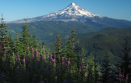
Fireweed frames Mount Hood from Waucoma Ridge

But in the spirit of bucking norms and traditions, how another option that could be a more complimentary, modern version of it’s weedy current name? Like Fireroot? Or Fireflower? How about Fireleaf? Nope… doesn’t quite work.

How about… Firestar! Hmm… this minor adjustment would honor its essential role in stabilizing burned forests, but with a positive spin – after all, it is a “star” in this role! What do you think?

Yes, it would be a really big lift. A quick web search reveals an aerospace company, energy crystals, software brand, sci-fi novel, rolling fire doors and… a mutant Marvel Comics superheroine! If all of the above are anything like the Yukon Territory, they’d be honored to share their corporate namesake with a beautiful wildflower, right?

Where to see Fire…. star!

Fireweed15

Fireweed crowds the Vista Ridge trail as it passes through the Dollar Fire burn

I’m not really sure how to go about establishing a new common name for a flower, but since many have multiple common names, it must be possible. So, why not try?

In that spirit, here are a couple of trails where you can enjoy magnificent displays of Firestar on the slopes of Mount Hood from mid-July into September:

Elk Cove Trail: this moderately steep trail travels through the heart of the 2011 Dollar Fire, passing near the origin of the fire just below the Coe Overlook and lots of Firestar. The overlook makes a good stopping point for those looking for a shorter hike, though Elk Cove is always a lovely place to spend an afternoon.

Vista Ridge to Eden Park & Cairn Basin: this moderately graded trail hikes through the western expanse of the 2011 Dollar Fire, passing fields of Firestar along the way before looping through idyllic Eden Park and Cairn Basin. Be prepared for a couple crossings of Ladd Creek, a glacial stream that fluctuates with summer melt on hot afternoons.

Enjoy!

A New Vision: Restoring Hiyu Mountain

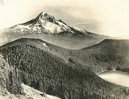
Hiyu01BullRunHood1900s

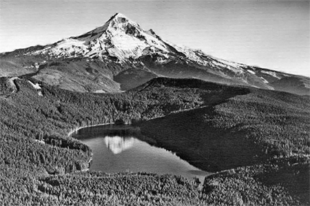
Early 1900s view of Mount Hood and Bull Run Lake, with Hiyu Mountain on the far right and Sentinel Peak on the left

Hidden in plain sight at the foot of Mount Hood and the headwaters of Portland’s Bull Run watershed, Hiyu Mountain is a little-known, much abused gem. No one knows why this graceful, crescent-shaped mountain was named with the Chinook jargon word for “much” or “many”, and sadly, only a very few know of Hiyu Mountain today.

This little mountain deserves better. The broader vision of the Mount Hood National Park Campaign is to heal and restore Mount Hood and the Gorge as a place for conservation and sustainable recreation, ending a century of increasing commercial exploitation and profiteering. As part of this vision, Hiyu Mountain could once again become a place of “hiyu” beauty, where snowcapped WyEast fills the horizon and where Bull Run Lake, indigo source of Portland’s drinking water, could finally be seen and celebrated by the public these lands belong to.

Two Worlds

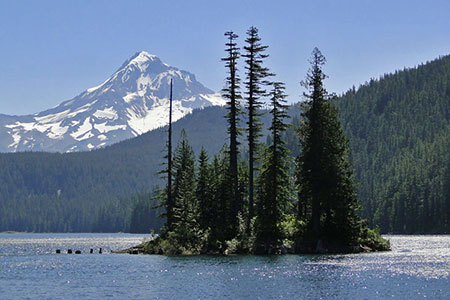
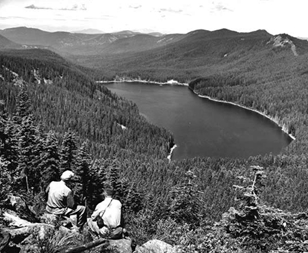
Hiyu02BullRunHood2010GuyMeacham

Dodge Island and Mount Hood from Bull Run Lake; Hiyu Mountain is the tall, crescent-shaped ridge rising behind the island (photo courtesy Guy Meacham)

Hiyu Mountain rises 1,500 feet directly above Bull Run Lake, the uppermost source of Portland’s water supply. Lolo Pass is on the south shoulder of the mountain, connecting the Hood River and Sandy River valleys. The two sides of Hiyu Mountain mountain couldn’t be more different.

The northern slope that forms the shoreline of the Bull Run Lake is almost untouched by man, almost as pristine as it was when the Bull Run Watershed was established in the late 1800s.

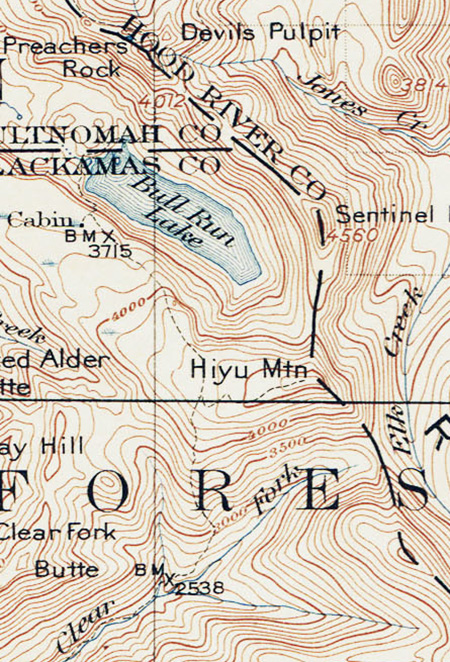
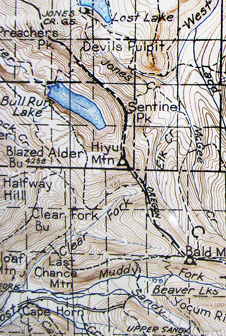
Hiyu03TopoMap1911

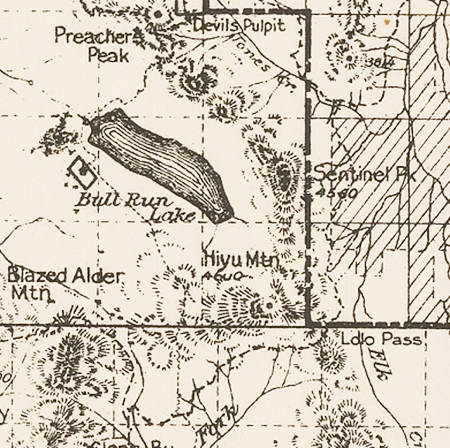
Early 1900s map of Hiyu Mountain and Bull Run Lake

Massive old growth Noble fir forests tower along these northern slopes, where rain and snow from Pacific storm fronts is captured, emerging in the crystal mountain springs that form the headwaters of the Bull Run River.

Almost no one visits this part of Bull Run, save for an occasional Portland Water Bureau worker. This land has been strictly off-limits to the public for nearly 120 years, and remained untouched even as the Bull Run Reserve was developed as a municipal watershed.

Hiyu04ForestMap1915

Early 1900s map showing Hiyu Mountain and the first trails over Lolo Pass

On the south slope of Hiyu Mountain things were surprisingly pristine until the 1950s. This area was also part of the original Bull Run Reserve, but was later ceded – in large part because the south slopes of Hiyu Mountain drain to the Clear Fork of the Sandy River, and away from the Bull Run watershed.

Since the 1950s, a conspiracy of forces has almost completely altered the south face of the mountain and its summit crest. By the mid-1950s, the Forest Service had begun what would become an extensive industrial logging zone here, mining ancient trees in dozens of sprawling, high-elevation clear cuts in the remote Clear Fork valley.

These forests will take centuries to recover, and are today mostly thickets of plantation conifers in woeful need of thinning. The maze of logging roads constructed to cut the forests are now buckling and sliding into disrepair on the steep mountain slopes.

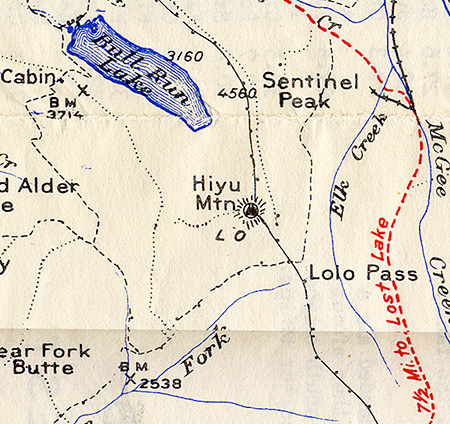
Hiyu05TopoMap1927

1927 map of Hiyu Mountain, Bull Run Lake and the south corner of Lost Lake

By the late 1950s, a logging road had finally pushed over the crest of Lolo Pass. At just 3,330 feet, Lolo is the lowest of mountain passes on Mount Hood and a route long used by Native Americans. But surprisingly, it was the last to see a road in modern times. The road over Lolo Pass coincided with the completion of The Dalles Dam in 1957, some 50 miles east on the Columbia River.

While the dam is most notorious for drowning Cello Falls, a place where native peoples had lived, fished and traded for millennia, it also sent half-mile wide power transmission corridors west to Portland and south to California. Thus, the new road over Lolo Pass enabled the most egregious insult to Hiyu Mountain, with the parade of transmission towers we see today tragically routed over the shoulder of Mount Hood.

The power corridor took advantage of the easy passage over Lolo Pass, an absence of tourists and public awareness (at the time) on this remote side of the mountain, and was built with complete disregard for the natural landscape. It remains as Mount Hood’s worst scar.

Hiyu06TransmissionLines

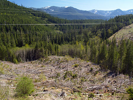
The Bonneville Power Administration’s quarter-mile wide perpetual clearcut that follows their transmission lines over the shoulder of Hiyu Mountain

 Today, the south side of Hiyu Mountain remains a jarring landscape of ragged clearcuts, failing logging roads and the quarter-mile wide swath of power lines.

With regular clearing and herbicides, the Bonneville Power Administration (BPA) ensures that nothing much grows under its transmission lines except invasive weeds. It’s a perpetual, linear clearcut that serves primarily as a place for illegal dumping and a shooting range for lawless gun owners who ignore (or shoot) the hundreds of BPA “no trespassing” signs. It is truly an ugly and shameful scene that cries out for a better management vision.

The Lookout Era

Hiyu07Lookout1930

The original lookout tower on Mount Hood in the late 1920s

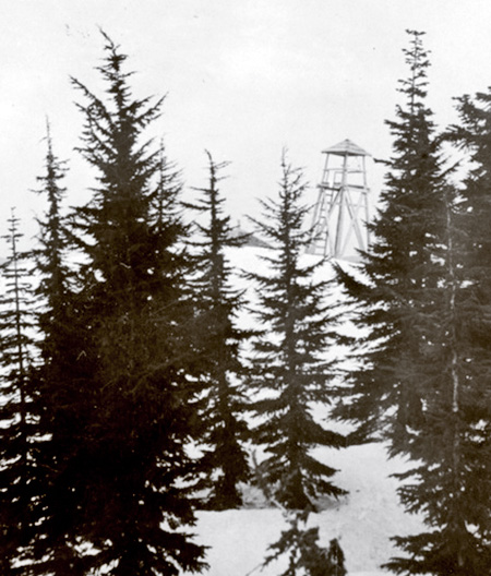
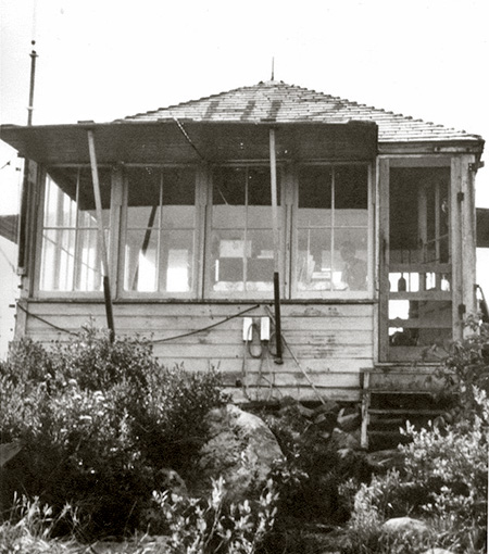
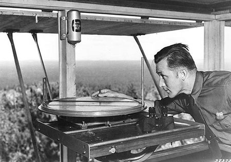
By 1929, the Forest Service had built a 20-foot wooden lookout tower with an open platform atop Hiyu Mountain (above). It was an ideal location, with sweeping views of both the Bull Run Reserve and the entire northwest slope of Mount Hood. A roof was soon added to the original structure, but in 1933 a more standard L-4 style lookout cabin replaced the original structure (below). The new lookout provided enclosed living quarters for lookout staff, complete with a cot, table and wood stove – and an Osborne fire finder in the center of the one-room lookout.

Hiyu08Lookout1933

The 1933 Hiyu Mountain Lookout in the 1950s

Hiyu09Firefinder

Osborne Fire finder in the 1930s (USDA)

When the new Hiyu Mountain lookout was constructed in 1933, the Forest Service was also completing a comprehensive photographic survey from its hundreds of lookout sites throughout Oregon. These photos are now an invaluable historical record. Forest Service photographers used a special panoramic camera to capture the full sweep of the view from each lookout, creating a trio of connecting panoramas from each location.

The following photographs are taken from a panoramic survey at Hiyu Mountain in 1934, and tell us what the area looked like in those early days.

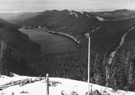
The first photo (below) looks north, toward Bull Run Lake, but also shows the fresh fire lane cut into the forest along the Bull Run Reserve boundary – visible on the right and along the ridge at the top of the photo.

Hiyu10BullRunLakeView1934

Bull Run Lake from Hiyu Mountain in 1934

(click here for a larger photo)

The fire lane is no longer maintained and has now largely reforested. The northern view also shows a simple wind gauge mounted on a pole below the lookout tower and the perfect cone of Mt. St. Helens on the horizon, as it existed before its catastrophic 1980 eruption.

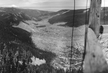
The view to the northeast (below) shows Mount Adams on the distant horizon, and a completely logged West Fork Hood River valley, below. The Mount Hood Lumber Company milled the old growth trees cut from this valley at the mill town of Dee, on the Hood River. The ruins of their company town (and a few surviving structures) can still be seen along the Lost Lake Highway today. Trees cut in the West Fork valley were transported to Dee by a train, and a portion of today’s Lolo Pass road actually follows the old logging railroad bed.

Hiyu11WestForkView1934

The logged-over West Fork valley from Hiyu Mountain in 1934

(click here for a larger photo)

Unfortunately, much of the West Fork valley continues to be in private ownership today. Longview Fiber owned the valley for decades, but sold their holdings in a corporate takeover in the late 2000s to a Toronto-based Canadian trust. More recently, Weyerhauser took ownership of the valley, and has embarked on a particularly ruthless (and completely unsustainable) logging campaign that rivals the complete destruction seen in these photos from the 1930s (watch for a future WyEast Blog article on this unfortunate topic).

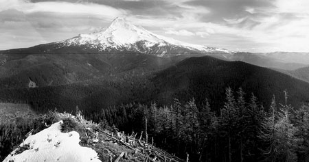
To the southeast (below), Mount Hood fills the horizon in spectacular fashion, but there are some interesting details in the photo, too. In the foreground, the rocky spur that forms the true summit of Hiyu Mountain has been cleared to enhance the lookout views. The continued swath of logging in the West Fork valley can be seen reaching the foot of Mount Hood on the left.

Hiyu12HoodView1934

Mount Hood from Hiyu Mountain in 1934

(click here for a larger photo)

A detailed look (below) at the western panorama in the Hiyu Mountain series shows a lot of cleared forest, a necessity as the summit ridge continues in this direction for than a mile, blocking visibility for the new lookout. In this detailed scene, we can also see stacked logs and lumber that were presumably used to build a garage and other outbuilding that were added to the site in the 1930s.

Hiyu13WestView1934

Recently cleared trees at the Hiyu Lookout site in 1934

 (click here for a larger photo)

When it was constructed, the lookout on Hiyu Mountain was remote and reached only by trail. Materials for the new structured were brought in by packhorse. The nearest forest guard station was at Bull Run Lake, where Portland Water Bureau rangers staffed log cabins while guarding the water supply.

A dense network of trails connected the Hiyu Mountain lookout to Bull Run Lake and other lookouts in the area. As the 1930s era Forest Service map (below) shows, a telephone line (the dash-dot line) also connected Hiyu Mountain to other lookouts on Hiyu Mountain and to the cabins at Bull Run Lake. The phone line north of the lookout followed the fire lane, and is likely still there, lost in the forest regrowth.

Hiyu14TrailsMap

1930s map of Hiyu Mountain showing the extensive trail network of the pre-logging area

The 1930s forest map also shows the original alignment of the (then) new Oregon Skyline Trail, now the Pacific Crest Trail (PCT). According to the map, the trail crossed right through the logged-over area of the West Fork valley (between the tributaries of Elk Creek and McGee Creek on the map) in the 1934 panorama photos, so not exactly a scenic alignment. Today’s McGee Creek trail is a remnant of this earlier route from Mount Hood to Lost Lake.

Today’s PCT stays near the ridge tops, roughly following some of the old forest trails from Mount Hood to Lolo Pass, then across the east slope of Hiyu Mountain, toward Sentinel Peak. A 1946 forest map (below) shows the Oregon Skyline Trail to already have been moved to the ridges between Bald Mountain and Lost Lake, though the area was still without roads at the time.

Hiyu15_1946TrailsMap

1946 forest map of the Hiyu Mountain area – oddly, Lolo Pass is not even marked!

By the early 1950s, there were dozens of forest lookouts in the area north of Mount Hood, with structures on nearby Buck Mountain, Indian Mountain, Lost Lake Butte, Bald Mountain, East Zigzag Mountain, West Zigzag Mountain and Hickman Butte. All were within sight of the lookout on Hiyu Mountain, and must have provided welcome — if distant – company to lookout staff.

During the 1950s, roads were finally pushed into the Clear Fork valley and over Lolo Pass as the industrial logging era began on our national forests. During this period, a logging road was constructed between Lolo Pass and Bull Run Lake, including a spur that climbs to the summit of Hiyu Mountain.

Hiyu16BullRunView1953

Bull Run Lake from Hiyu Mountain in the 1950s

Though not widely known today, the logging agenda of the U.S. Forest Service from the 1950s through the 1980s did not spare the Bull Run Reserve. In the 1960s and 70s, alone, some 170 mile of logging roads were cut into the mountain slopes of Bull Run. By the 1990s, 14,500 acres of these “protected” old growth forests of 500-year old trees had been cut, or roughly 20 percent of the entire watershed had been logged. Public protests and legal challenges to stop the logging began as early as 1973, but only in 1996 did legislation finally ban the destruction of Bull Run’s remaining ancient forests.

By the early 1960s, the Forest Service had begun to phase out the forest lookouts, and Hiyu Mountain’s lookout structure was removed by 1967. Since then, the main function of the summit road has been to log the south slope and summit ridge of the mountain and to provide access to radio antennas where the old lookout building once stood. The easy road access to the summit also brought one of Mount Hood’s seismic monitors to Hiyu Mountain in more recent years.

The Ridiculous Red Zone

Hiyu17BullRunLake1960

Hiyu Mountain is the long, dark ridge rising above Bull Run Lake and in front of Mount Hood in this 1960s photo

As recently at the 1980s, it was still legal – and physically possible – to follow the old, unmaintained lookout trail from Lolo Pass to the summit of Hiyu Mountain. Sadly, the Forest Service has since officially closed the trail as part of their stepped-up campaign with the City of Portland Water Bureau to deny any public access to the Bull Run Reserve, even for areas outside the physical watershed.

A few have dared to follow the Hiyu Mountain trail in recent years, and report it to be overgrown, but in excellent shape. The trail climbs through magnificent old Noble fir stands before emerging at the former lookout site. The route doesn’t come remotely close to the actual water supply in Bull Run, which underscores the ridiculousness of the no-entry policy.

Meanwhile, in recent years the City of Portland has been forced to flush entire reservoirs at Mount Tabor and in Washington Park because of suspected contamination from vandals. Yet, these reservoirs continue to be completely accessible and uncovered and in the middle of the city, protected only by fences.

Hiyu18BullRunLakeHiyuPWB

Mount Hood from Bull Run Lake – Hiyu Mountain is the tall ridge immediately in front of Mount Hood in this view (Portland Water Bureau)

Why so little security in the middle of Portland, where the actual water supply is in plain sight and easily vandalized, and so much security where there is little chance of coming anywhere near the water source?

The answer seems to be a mix of dated laws, entrenched bureaucracy and a heavy dose of smokescreen marketing. Portland’s water supply has been under scrutiny by federal regulators in recent years for its vulnerability to tampering – or, perhaps more likely, natural hazards like landslides (Bull Run Lake was created by one, after all), catastrophic forest fires or even a volcanic eruption at nearby Mount Hood. This is because the water coming into city pipes is currently unfiltered.

Hiyu19TourBus

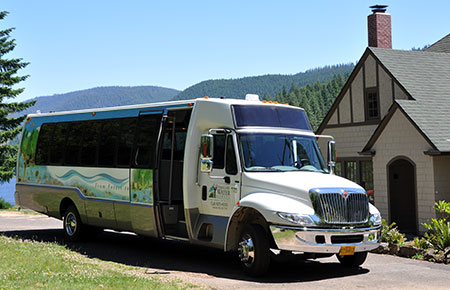
Portland’s Water Bureau provides day tours for a limited number of Portlanders each summer willing to pay $21 for the trip. This is the only way the public can legally visit Bull Run (Wikimedia)

Portland’s elected officials are loathe to fund the price tag for modernizing the system to make it more safe and resilient. In their effort to avoid having to fund and build a filtration system, the City has instead relied heavily on the feel-good mystique of the Bull Run Reserve as a pristine, off-limits place where such measures simply aren’t needed. So far, Portlanders seem content to buy this excuse for preserving the status quo.

That’s too bad, because it’s always shortsighted to exclude the public from access to our public lands, especially if the purpose is as important as ensuring safe drinking water in perpetuity.

A better approach for both the City and the Forest Service would be just the opposite: look for opportunities to involve Portlanders in their Bull Run watershed, including trails like the route to Hiyu Mountain that could give a rare look at the source of our drinking water. Which brings us to…

A New Vision for Hiyu Mountain?

Hiyu20TillamookForestCenterTribune

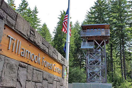
The popular reproduction lookout tower at the Tillamook Forest Center (Portland Tribune)

We already have a model for honoring Hiyu Mountain’s history at the Tillamook Forest Center, in Oregon’s Coast Range. This relatively new interpretive site is occasionally mocked for its prominent forest lookout tower without a view, but the purpose of the lookout is to educate visitors, not spot fires. Each year, thousands of visitors get a glimpse of how these lookouts came to be, and why they have largely disappeared from the landscape.

A similar project could work at Hiyu Mountain, though a restored lookout tower there could be for the dual purpose of educating visitors on both the history of forest lookouts and the story of the Bull Run Reserve, with birds-eye view of Bull Run Lake from the tower. A restored Hiyu Mountain tower could also provide a more aesthetic alternative for mounting Forest Service communications equipment now installed on top of the mountain.

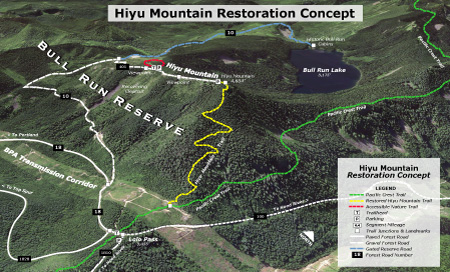
The concept below would reopen the road to the summit of Hiyu Mountain to the public, with a restored lookout tower as the main attraction. Visitors would have stunning views of Mount Hood and into Bull Run Lake. The old lookout trail from Lolo Pass would also be reopened, providing a way for more active visitors to explore the area and visit the restored lookout tower.

Hiyu21ConceptMapSmall

(Click here for a larger map)

This concept would not put anyone in contact with Bull Run Lake or any of Portland’s Bull Run water, though it would provide a terrific view of the source of our drinking water. It would also pull back the shroud of secrecy around our watershed that allowed hundreds of acres of irreplaceable Bull Run old growth to forest be quietly logged just a few decades ago – the very sort of activity the public should know about when it’s happening on our public lands.

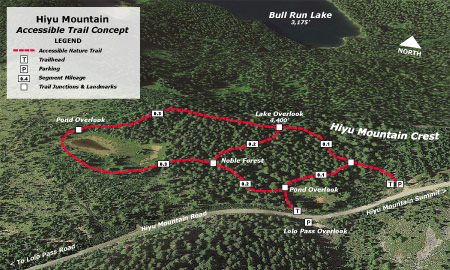
Another feature in this concept is an accessible trail (see map, below) to viewpoints of Bull Run Lake and a pair of scenic ponds that somehow survived the massive Forest Service clearcutting campaign on Hiyu Mountain’s crest.

The idea is to provide much-needed trail experiences for people with limited mobility or who use mobility devices, such as canes, walkers or wheelchairs. Trails with this focus are in short supply and demand for accessible trails is growing rapidly as our region grows. Why build it here? Because everyone should be able to see and learn about their water source, regardless of their mobility.

Hiyu22AllAccessTrailMapSmall

(Click here for a larger map)

These recreational and interpretive features would also allow Hiyu Mountain to begin recovering from a half-century of abuse and shift toward a recreation and interpretive focus in the future. While logged areas are gradually recovering, the area will need attention for decades to ensure that mature stands of Noble fir once again tower along Hiyu Mountain’s slopes.

What would it take..?

What would it take to achieve this vision? The Hiyu Mountain lookout trail is in fairly good shape, and could be restored by volunteers in a single season if the entry ban were lifted. The concept for an accessible loop could be funded with grants that specifically target accessible trails if the Forest Service were to pursue it. And forest lookout organizations already maintain several historic lookouts in Oregon, so they could be a resource for recreating and maintaining a lookout at Hiyu Mountain.

Hiyu23BullRunGate

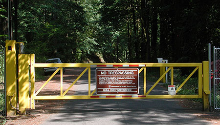
Welcome to your Bull Run watershed… (Wikimedia)

Most of the infrastructure is already in place, and just waiting for a better management vision for Hiyu Mountain. I’ve described one here, and there are surely others that could provide both public access and restoration.

But only the U.S. Forest Service and City of Portland Water Bureau can move us away from the antiquated entry ban at Bull Run. Hiyu Mountain would be the perfect place to start!


Meet Brian Chambers!

BrianChambers01

Editors note: periodically, I feature local artists and writers in this blog. Brian Chambers is a local photographer in Hood River who has been capturing stunning images of Mount Hood and the Columbia River Gorge. Here’s a recent conversation with Brian.

Brian has also offered to donate a portion of any sales resulting from this interview to the Friends of the Gorge, Trailkeepers of Oregon (TKO) and the Columbia Land Trust, so be sure to mention the blog if you purchase Brian’s photos! (more info following the interview)

_______________

WyEast Blog: Great to meet you, Brian! How long have you been shooting landscape photography in the area?

Brian Chambers: I first came to Hood River on vacation in 1996. I immediately fell in love with the place and had moved here within one year. That was back in the old days of film. I had done a ton of photography way back in high school and had my own darkroom but did less and less as I got older. I was doing a little bit of photography when I moved here but it wasn’t until I bought my first DSLR in 2008 that my hobby became a full-blown addiction.

BrianChambers02SevenmileHill01

Mount Hood from the Eastern Gorge

(click here to view a large version in Brian’s gallery)

WyEast: What are your favorite Gorge locations for shooting – the ones you go back over and again?

Brian: It changes so much from year to year. I tend to find a new location and maybe pre-visualize some images in my mind. I will go back over and over until I am satisfied with the images I can capture with my camera. I will keep trying until I get that special combination of light and composition that really matches what I had seen in my mind.

The thing I like the most about the gorge is the variety. If I had the energy I could shoot a fresh snow fall on a mountain stream at sunrise, at lunch take on moss covered waterfall, at sunset capture the most amazing wildflower scene, and a midnight capture an abandoned house in the middle of a wheat field. I really feel the options are arguably the best in the country.

BrianChambers03UpperHoodValley

Upper Hood River Valley orchards at sunrise

 (click here to view a large version in Brian’s gallery)

Some of my favorites include shooting the orchards of Hood River, Hood River itself with the river in the foreground and the mountain behind it, the view down the gorge anywhere there is exciting light from places like Rowena, Underwood viewpoint, Mitchell point. I have been heading to some of the more off-trail waterfalls and really enjoying the exploring aspect of that. I love Mt Adams in the fall for the color. I could go on all day.

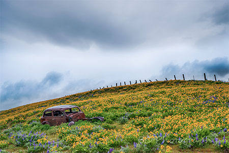
Early in the spring I am really drawn to the east hills. A few years ago it was the Rowena crest, then it was Dalles Mountain, then it was the Memaloose Hills Hike area.

BrianChambers04RowenaSunrise

Sunrise a Rowena Crest

(click here to view a large version in Brian’s gallery)

WyEast: What makes those locations special?

Brian: One big factor is the flowers. Especially this year, although it was an early bloom, it was off the charts good. I don’t think I have ever seen it that good. I love the openness of the land, being able to see the light interacting with terrain. The different compositional options, with 360 degree views and the amazing mountain and gorge views in the background. Sitting in a field of wildflowers all alone watching the rising sun dancing with Mount Hood and lighting up the flowers. It doesn’t get much better than that.

WyEast: What about your favorite Mount Hood locations?

Brian: Well in the winter I spent a ton of time snowshoeing up the White River. It has such an easy access to an amazing mountain view with the river in the foreground. I am almost embarrassed to say how many times I have gone up there looking for the perfect light. I finally got a couple of images I am pretty happy with this year. Persistence can pay off.

BrianChambers05WhiteRiverSunrise

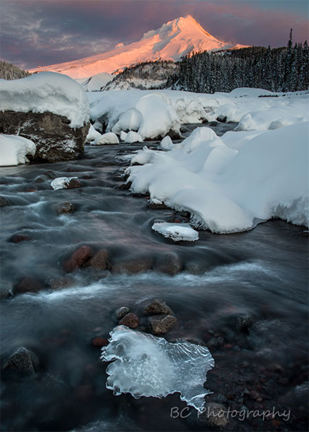
Sunrise on Mount Hood and the White River

 (click here to view a large version in Brian’s gallery)

In the summer I often am heading up to the WyEast Basin and Cairn Basin area. I like that you can take several different trails to get there and it is this wonderful mix of high alpine, lush wildflowers, refreshing streams and small waterfalls with some of the best close-up views of the mountain. The number of great subjects in such a small area is almost mind-boggling.

WyEast: Some of your most stunning photos are shot during the golden hours of early morning or evening – do you have any tips for shooting in those conditions?

Brian: Getting up earlier and staying out later is usually the simplest thing people can do to greatly improve their photography. It is very difficult to get as compelling a photo in the middle of the day. The rapidly changing light around sunrise and sunset can really add a ton of interest, color and excitement to your images. Watch the sky, satellite images and weather forecasts to see if there is going to be enough clouds to make the sky interesting but not too many so that the sun is blocked.

BrianChambers06CairnBasin

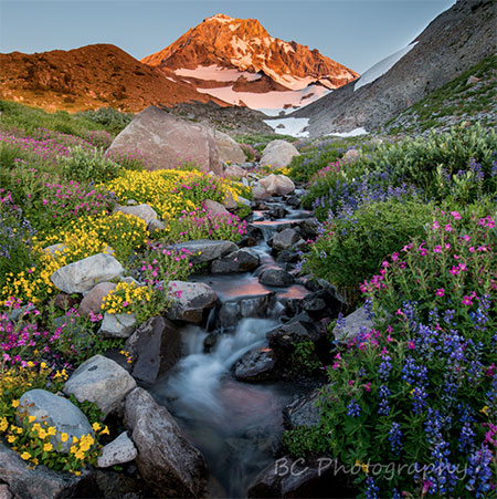
Late afternoon wildflowers near Cairn Basin on Mount Hood

 (click here to view a large version in Brian’s gallery)

A tripod is critical for getting clear shots when it is darker. I suggest shooting in RAW not JPEG and bracketing your exposures to capture all of the detail in the brightest and darkest parts of the image.

Be Patient. I can’t tell you the number of times I have been taking pictures and all the other photographers have left and 10 minutes after a boring sunset the sky just lights up.

BrianChambers07AdamsSunset

Autumn sunset at Mount Adams

(click here to view a large version in Brian’s gallery)

That being said, I would be lying if I didn’t say I am just like everyone else in that I sometimes can’t pull myself out of bed in the early morning and I sometimes head to the brewpub at sunset rather than out to shoot. My family is pretty tolerant of me heading out to shoot but I try to balance life and responsibility with photography. Find the balance that makes you happy.

WyEast: You also have some amazing photos that feature the night sky. How exactly do you capture those images?

Brian: It is surprisingly easy if you have a fairly new digital camera. Have a solid tripod. I suggest getting to your location before it gets dark. Set up all your gear, compose your image and focus. Cameras are unable to auto-focus in the dark so you need to focus before it gets too dark and then set your camera to manual focus so it will not try to refocus.

Start taking pictures before it is totally dark and see what happens. Learn how to adjust your camera in manual exposure. Set your aperture to wide open (the smallest number possible), your shutter speed to around 20 or 30 seconds. Crank your ISO up to 800 or 1600 or even higher and fire away. The beauty of digital is it doesn’t hurt to mess up. If it is too dark crank up your ISO higher or lengthen your shutter speed. If it is too bright turn your ISO down.  Look at your results and see what works and what doesn’t. Play and have fun.

BrianChambers08CooperSpurStars

Milky Way and Mount Hood from below Cooper Spur

 (click here to view a large version in Brian’s gallery)

WyEast: Those are great tips! Some of your images of Mount Hood and the Gorge also feature lightning, which seems especially challenging to capture. Other than not standing on high ground – which, actually, it looks like you were – what can you tell us about getting a great lightning photo?

Brian: First of all be safe. I think a lot photographers tell stories of risking life and limb to “get the shot”. Probably not worth it and often just an embellishment to make it sound more dramatic. I like to find a place where I can shoot while sitting in the car or at least find shelter immediately.

BrianChambers09EastGorgeLightning

Thunderstorm lighting up the East Gorge

(click here to view a large version in Brian’s gallery)

It helps to have a cable release or some other way of triggering your camera like a remote control. That allows you to be safe in the car while the camera is outside. If it is dark and you can use a long exposure you can just set the camera to shoot continuously. Sort of a “spray and pray” method but there is nothing worse than missing that solitary lightning bolt.

If it is daylight, the “spray and pray” method doesn’t work because most cameras get bogged down and stop shooting after 20 seconds or so. In that case you can just watch and try to push the button with every strike. It sounds impossible but it can work with a little practice. We don’t get much lightning here so I have yet to invest in a lightning trigger but it’s a device that senses the lightning and takes the photo for you. Pretty handy if you do a ton of lightning shots.

BrianChambers10LostLakeLightning

Lightning at Mount Hood and Lost Lake

 (click here to view a large version in Brian’s gallery)

I have a couple of apps that show you live lightning hits so you can see if it’s worth heading out. And be ready if the conditions change. One of my favorite lightning shots at Lost Lake (above) was purely luck. I was there to take a photo of the sunset when a small storm popped up. I kept taking pictures until I got my shot.

WyEast: You’re based in Hood River, Brian. I’m wondering where you see the fine art scene going in the Gorge over the long term? Do you see art becoming a significant part of the Gorge and Mount Hood economy in the future?

Brian: It is definitely growing. I don’t think there were any art galleries in town when I moved here in 1997. Now it seems like there is one on every block. Many restaurants and breweries also display local artists. Hood River has over 20 new outdoor works of art on display around town. There are so many talented artists in the gorge. I think people are drawn to the quality of life and inspired by amazing beauty at our doorstep.

BrianChambers11StormyGorge

Stormy Gorge evening

(click here to view a large version in Brian’s gallery)

Art can play a significant part in the economy. It is just one more great reason for people to visit the gorge and it fits well with the winery and brewery tours, the Fruit Loop orchard tour and outdoor recreational tourism that the gorge is so rightly known for. I think the artwork can be a long-term reminder of the specialness of the area and for both tourists and people who live here. I love when people look at one of my pictures and it reminds them of some special times they have had here.

BrianChambers12SpiritFalls

Spirit Falls on the Little White Salmon River

(click here to view a large version in Brian’s gallery)

One thing that I am very excited about is helping to organize a temporary art gallery event in downtown Hood River on July 1st -3rd week. Eighteen local artists, including myself, have banded together to showcase and hopefully sell our work. We are having beer and wine and small plates of food, with an opportunity to view work from wide variety of different types of artists.

We will all be on hand all three days to discuss our artwork. The event will be at 301 Oak Street in downtown Hood River. I encourage anyone interested to stop in and say “hello”!

WyEast: That sounds like a great event, Brian! As an artist working in the Gorge, what are some of the challenges you’ve faced in becoming established?

Brian: It has been a slow steady process. Sometimes it seems agonizingly slow.  When I first started taking pictures I didn’t dream that people would want to purchase them. I looked around and saw so many great photographers.

BrianChambers13DufurHomestead

Abandoned homestead near Dufur, Oregon

 (click here to view a large version in Brian’s gallery)

Early in my progression as a photographer I was lucky enough to be accepted into the Columbia Center for the Arts. At that time it was a critical place of support for me. They encouraged me and treated me as a true artist so that I began to think of myself that way. I started to sell some work and began to grow in confidence. Every year they would have a photo contest and I was fortunate enough to win first place among hundreds of entries, including some really talented photographers.

That was a big step for me. Then I branched out and started displaying my work in local bakeries, restaurants and brewpubs. I started to gain more followers and confidence. In the last year or so, I have started to post more consistently on Facebook (www.facebook.com/BrianChambersPhotography/) and connect with people there.

BrianChambers14GorgeHike

Brian teaching photography on a recent Friends of the Gorge outing

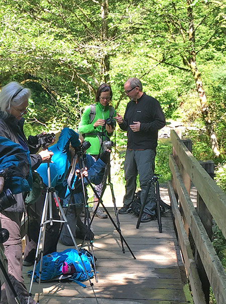
I have also begun teaching a little (including the Friends of the Gorge hike where we met). It is something I really enjoy and want to get better at, and something I have considered doing more frequently in the future.

Hood River is full of talented photographers and artists and most of them have been really supportive and welcoming to me.

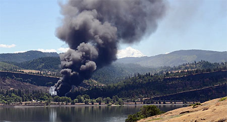
WyEast: When we met recently on that Friends of the Gorge hike, we talked about the controversy over oil and coal trains traveling through the Gorge. Since then, of course, a worst-case scenario unfolded when an oil train derailed in Mosier on June 3 of this year. What are your thoughts on the oil and coal trains moving through the Columbia River rail corridor?

Brian: That was a real eye opener for me.  I had been out for a road bike ride in the exact location ½ hour before the accident. When I heard about it I actually went to take pictures from across the river. You can see a time lapse I took on my Facebook page. Just watching all the black smoke block out the view of Mt Hood was really a horrible sight.

BrianChambers14OilTrainStill

Brian captured this video of the June 3rd oil train crash in Mosier, Oregon

 (click here to view a large version of this video in Brian’s gallery)

I got stuck in a traffic jam heading home. It took me 2 hours to get home when it would normally take me 10 or 15 minutes. It really made me think about how the unique geography and infrastructure of the Gorge can really amplify any disaster. There are very limited driving options, and if one or two roads are closed people can become trapped.

I also think the accident was not a worst-case scenario. It was lucky it didn’t happen in the center of Mosier or Hood River, where there is a lot more potential for damage and it was lucky it happened on an unusually light wind day. If it had been windy I can only imagine how bad the fire could have been.

WyEast: You’ve hiked the trails of Mount Hood and the Gorge and have seen the growing crowds. Many are concerned that the area is being loved to death. What are your thoughts?

Brian: Wow, what a question. This is something I think about almost daily. Even in my short time here I have seen a tremendous change in the volume of hikers to areas that were once quiet and relatively unknown, like the Columbia Hills Park and Memaloose Hills. I used to go there in the spring and see almost no one. This year they were just packed with people. Which, on one hand, is wonderful that people are out there learning to love the gorge and discovering new places. It is great for society that people are out exercising and recharging in nature. I feel like people will fight to save places once they see how special they are.

BrianChambers16ColumbiaHills

Columbia Hills State Park in spring

 (click here to view a large version in Brian’s gallery)

On the other hand, overcrowded trails and unsafe parking lots are a real concern and take away from everyone’s enjoyment.  As a photographer, I am always looking for the un-crowded wild places and I am afraid as I share them I might be contributing to them becoming crowded and over used.

There is an area near The Dalles that I am just in love with right now and I went there more than a dozen times the last couple years during the wildflower bloom and saw less than a handful of other hikers, and usually didn’t see anyone. Although part of the reason for that is starting my hike before 5 AM! I am torn between never telling anyone about it and wanting everyone to know how amazing it is. The word is already getting out and I suspect it will be packed in a couple years.

BrianChambers17SevenmileHill02

Mount Hood from an “undisclosed location”…

 (click here to view a large version in Brian’s gallery)

I guess I am an optimist. Nature seems to have the ability to not just heal people, but also itself. Just last week I was walking through the Dollar lake fire on Mt Hood. A few years ago it was a scene of total destruction. Everything dead and blackened. Now it’s hard to see the ground due to the huge number of flowers. If we can just try to get out of the way the land can usually do amazing things to recover from damage.

BrianChambers18GorgeSunset

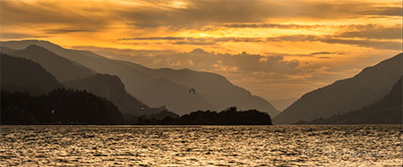
Gorge Sunset near Mitchell Point

 (click here to view a large version in Brian’s gallery)

Ultimately, I think the best answer is more trails. That is why I fully support the work you and others like you are doing. Saving the remaining wild places and creating sustainable hiking trails. I hope as the crowds worsen that will become a bigger priority for more and more people.

WyEast: Last question, and one you probably knew was coming: you’re a veterinarian by trade, so I’m wondering if you’d like to weigh in on bringing dogs into the Gorge? And in particular, what are some tips you would offer for keeping dogs (and people) safe, based on your experiences as a care giver?

Brian: Well, one disease that people new to the area may not have heard of is salmon poisoning. Don’t let your dog eat raw salmon or steelhead. It can cause severe vomiting and diarrhea that can be fatal. As I am sure all hikers already know, there are a few ticks in the area! There are plenty of good tick control medications available for your dog.

BrianChambers19GorgeRainbow

East Gorge rainbow

 (click here to view a large version in Brian’s gallery)

There are lots of dangers out on the trails and roads most of which can be avoided by keeping your dog on a leash and using common sense. I just recently saw a dog that was bitten by a rattlesnake on Dog Mountain. I have seen dogs killed by heat stroke, dogs killed by trains, falls from cliffs, cuts caused by skis, dogs lost in the wilderness, attacked by coyotes and other wild animals, falls from the back of pickup trucks, and too many hit by cars to count.

We also have a lot of poison oak in the Gorge. Keeping your dog on a leash is also a good way to make sure he stays out of poison oak, which can also be transferred to you from your dog’s coat.

BrianChambers20McCallSunset

Spring sunset in the Gorge from Memaloose Hills

 (click here to view a large version in Brian’s gallery)

Lastly, just like you and I, you should avoid overdoing the activity level for your dog’s fitness level. If you have an out of shape dog that doesn’t exercise, don’t start with a long bike ride on a hot day. As your dog starts to age you need to start to reduce the length of the hikes and bikes to ones that will not cause them pain or distress.

It can be hard to do because the dogs often want to go, even when their body is unable. Talk with your vet if your dog is slowing down or seeming stiff and sore, as there are plenty of options to help with that.

WyEast: That’s great information! Thanks for taking the time to chat, Brian – and for celebrating the Gorge and Mount Hood with your amazing photography. We look forward to seeing more of your work!

Brian: It really was my pleasure.

_______________

You can support Brian Chambers’ photography by following him on Facebook:

Brian Chambers Photography on Facebook

Through July 15th, Brian will be donating 20% of proceeds from photos he sells to people who mention this article to the Friends of the Gorge, Trailkeepers of Oregon (TKO) and the Columbia Land Trust, so it’s a great time to support him! (please note that this excludes the July 1-3 pop up gallery)

 Check out more of Brian’s images at:

Brian Chambers Gallery on Zenfolio

 And you can contact Brian directly through e-mail by clicking here.

And finally, learn more about the July 1-3 pop up art gallery in Hood River at:

Art in the Gorge on Facebook


WyEast Roundup!

Lots going on as we enter 2016 in WyEast country, so this article is a bit of a roundup, beginning with yet another commemorative nod from our federal government in the form of…

Columbia River Gorge Priority Mail Express Stamp!

WyEastRoundup01Stamp01

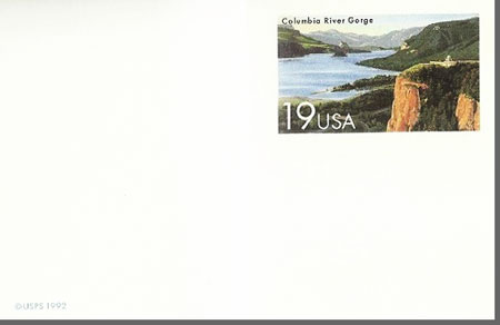
On December 30, 2015 the U.S. Postal Service released another stamp celebrating the Columbia River Gorge, joining the 1992 USPS postcard of the same, classic scene of Crown Point as viewed from Chanticleer Point (Women’s Forum Park).

WyEastRoundup01Stamp02

While the 1992 commemorative card was an affordable $0.19, the new Gorge stamp is a hefty $22.95, making for a steep addition to stamp collections! This new Priority Mail Express stamp is available in panes of 10 (for a mere $229.50!), and in the words of the Postal Service, the new stamp “celebrates the grandeur of the Columbia River Gorge” with the following:

Approximately 80 miles long and up to 4,000 ft. deep, the gorge runs along the Columbia River to form part of the border between Oregon and Washington. The stamp art captures the beauty of the Columbia River as it winds its way through the steep cliffs of the Cascade Mountain Range. The historic Vista House sitting atop Crown Point and overlooking the river 725 ft. below shimmers in the golden light of the setting sun.

Illustrator Dan Cosgrove of Chicago worked under the direction of Phil Jordan of Falls Church, VA, to create the stamp image.

The artists captured a faithful rendering of the scene, but I can’t help but wonder why a local illustrator wasn’t selected? After all, the Portland region is home to so many, including Paul A. Lanquist (PAL), the creative force behind dozens of “new retro” posters of Pacific Northwest scenes, like this view of Vista House:

Courtesy: Discover the Northwest

Courtesy: Discover the Northwest

So, save your money on that spendy USPS stamp and consider supporting a Northwest artist, instead. You can find Paul Lanquist’s posters at Discover the Northwest and many other outlets.

Still Creek Trails

As part of a recent series of articles on the Mirror Lake backcountry and Wind Creek Basin, I proposed the following concept for eventually expanding trails in this pocket wilderness:

WyEastRoundup02StillCreek01

(click here for large map)

After posting these articles, I happened to be researching the area for a related topic and was surprised to find many of my “proposed” trails on early maps. I’m going to chalk that up as “imitation being the sincerest form of flattery” as I’m sure I’ve studied these maps before, and must have noticed these earlier trails! Or so it would seem?

Nonetheless, it was a pleasant (re)surprise to discover that we once had a hefty trail network here, as it helps make the case for bringing more trails in this area to reality someday. Past is prologue! And who knows, maybe some of these old treads still survive?

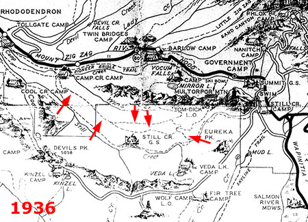
WyEastRoundup02StillCreek02

(click here for large map)

A closer look at the 1937 forest map (above, marked with red arrows) reveals a rim trail that followed the north side of Still Creek valley from Camp Creek to – what’s that? – a trail between Still Creek and Mirror Lake!

These old trails show up on a more “official” 1939 forest map (below), with added detail showing the connector to Still Creek continuing south to (what still exists today as) the Eureka Peak trail. This explains what has always been an odd trail fragment at Eureka Peak and raises the intriguing question of whether the segment north of Still Creek to Wind Lake and beyond still exists?

WyEastRoundup02StillCreek03

(click here for large map)

These old routes persist on forest maps dating into the late 1940s, when the commercial logging assault on our forests began wiping out hundreds of miles of old trails (below).

WyEastRoundup02StillCreek04

(click here for large map)

But Mirror Lake, the Wind Creek Basin and Still Creek valley were still recovering from the catastrophic Sherar Burn when the logging bonanza took off in the mid-1900s, and were mostly spared from clear cutting and logging roads. That not only gave today’s pocket wilderness, but it also bodes well for traces of these old trails to still survive – and someday be rediscovered and restored, perhaps?

Eliot Crossing Update

Lots of news on the Eliot Crossing proposal, first described in this WyEast Blog article from 2014. As reported earlier, the Forest Service is moving a trail project forward this year that will finally restore the missing section of the Timberline Trail at the Eliot Branch crossing.

The following map originally appeared in this blog, but later became a Trailkeepers of Oregon (TKO) map for the purpose of the Eliot Crossing project, and now is being shared with the Forest Service, as well:

WyEastRoundup03EliotCrossing

(click here for large map)

In January, Claire Pitner, Forest Service project manager for the new trail at the Hood River Ranger District, sent this good news to local non-profits involved in the project:

“I wanted to let you know that the environmental analysis for the Eliot Reroute was signed yesterday. Furthermore, earlier this week we received word that the Regional Office is providing funding to complete the project. Much of the work will be done using a contractor with volunteer assistance as well.

“We are working on finalizing the contract package in hopes of having a contractor long before we are able to access and do work at the site. I’m looking forward to working with TrailKeepers to get some good work done this summer!”

By early February, the local media picked up on the story with (surprise!) mentions of the WyEast Blog in The Oregonian and Willamette Week – a nice plug for the blog and the Eliot Crossing project!

In early March, the TKO board will be meeting with the Forest Service and several other non-profit organizations to begin planning volunteer activities related to the project. It should be a fun, family-friendly opportunity for volunteers to be part of the project, and I’ll post updates on the project as more details become available.

LG TV Mystery Mountain Ad

I’ll end the roundup on a whimsical note, courtesy LG, the electronics giant. I spotted the following print ad over the holidays and something about it looked too familiar – as it should have. This is our very own Trillium Lake…

Do not attempt to adjust your television…

Do not attempt to adjust your television…

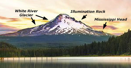
…except it isn’t, unless you’re looking in the rear-view mirror of your kayak (or canoe). A closer look at the mountain (below) shows all the major features of WyEast reversed, with a misplaced White River glacier flowing down the southwest slope of the mountain (imagine the mayhem in Rhododendron!), and poor Illumination Rock and Mississippi Head rudely moved to the east side of the mountain:

This looks vaguely familiar…

This looks vaguely familiar…

But the really goofy part of this ad is the appearance of what seems to be an Italian (Burano?) or perhaps Icelandic fishing village teleported to the Oregon Cascades:

Preview of a future Forest Service concession..?

Preview of a future Forest Service concession..?

As always, it’s good to see our mountain (and Gorge) making regular appearances in print media from around the world, even if the graphic artists can’t resist making a few improvements. Even with the artistic tinkering, these ads underscore the world-class nature of these amazing places… and their national park-worthiness, of course!

2016 Campaign Calendar!

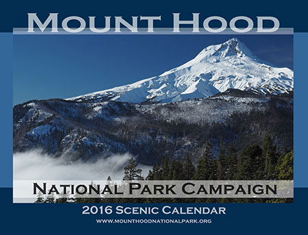
00aCalendarCoverGumjuwac

Each year since 2004, I’ve produced an annual “Mount Hood National Park Campaign Scenic Calendar”. It’s mostly for fun and to showcase the mountain (and Gorge) in a way that helps move beyond the too-often heard “it’s too [fill in the defeatist excuse] to become a national park.”

Wrong! In fact, the spectacular scenery, dramatic human history and sheer diversity of ecosystems in such a compact space make it a perfect candidate! Thus, the “idea campaign”, now entering its 12th year.

Each scenic calendar does put a modest $4 into keeping the campaign website and this blog up and running, but the main reason for picking one up is to simply enjoy looking at our someday national park through every month of the year. They sell for $29.95 over on my new campaign store:

Mount Hood National Park Campaign Store

If you’ve purchased a campaign calendar before, you’ll note that I’ve moved from CafePress to Zazzle for printing. This is in part due to CafePress dropping large format calendars from their offerings. But in truth, I’ve had mixed experiences with the company in recent years, and have heard the same from others who purchased calendars there. So, it was time to bail.

By contrast, Zazzle seems to provide a much better customer experience and the print quality is exceptional – especially compared to CafePress. I’ve been impressed, and I think you’ll be pleased, too!

Now, bear with me as I indulge in my annual reflections from the past year as illustrated by photos from the 2016 calendar…

The Cover Shot

00bCalendarCoverGumjuwac

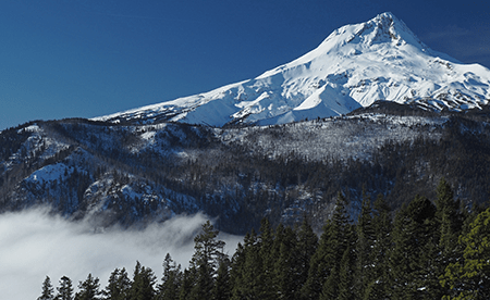
Mount Hood and valley fog from Gumjuwac Overlook

The view on the cover of the 2016 calendar is from a favorite viewpoint that is surprisingly unknown and never crowded. It’s along the Gumjuwac Trail, and the combination of a steady climb and not much information on maps or guidebooks to indicate a viewpoint seems to have kept this spot out of the mainstream… for now!

The cover shot came on one of those bright blue mountain days when the East Fork Hood River valley was blanketed in dense, freezing fog, thanks to a classic temperature inversion.

00cCalendarCoverGumjuwac

Silver thaw on vine maple along the Gumjuwac Trail

The temperature at the trailhead along the East Fork that November day was a foggy 28 degrees. The first part of the climb along the Gumjuwac Trail was through a wonderland of glazed trees before breaking out of the fog about 1,500 feet above the trailhead. There, the temperature was suddenly in the 40s and allowed for a relatively balmy lunch in the sun!

The Monthly Images

For the January image in the 2016 calendar, I chose a photo taken along the historic Bennett Pass Road (below) after the first big snowfall of the 2014-15 winter season. As it turned out, it was also the last big snowfall! We soon entered a long year of drought in the Pacific Northwest that left the Cascades with the lightest snow pack in years.

01CalendarBennettPass

January features Mount Hood from Bennett Pass Road

The February image of the north face of Mount Hood (below) was taken from a mostly bare Old Vista Ridge Trail in mid-May, with a fresh coast of spring snow at the upper elevations of the mountain that belied the ongoing drought. The trail would normally have 5-10 feet of snow on the ground at that time of year, but the drought of 2015 was already well underway, and many mountain trails were eerily snow-free by early June.

02CalendarNorthFace

February features a close-up of the north face of Mount Hood

For March, I chose a close-up photo of Wahclella Falls (below) on Tanner Creek taken in early May. This has become one of the most popular trails in the Gorge, and remains my favorite, as well. In 2015, I hiked this lovely trail a total of seven times, spanning the four seasons.

On this particular trip, an impromptu, full-blown Bohemian wedding unfolded on the rocks above the falls while I was shooting this image – complete with baskets of rose petals and various acoustic instruments wafting (somewhat in tune) above the roar the falls. It was undoubtedly an unforgettable wedding for the lucky couple, and just another quirky Gorge experience for hikers passing through..!

03aCalendarWahclellaFalls

March features Wahclella Falls on Tanner Creek

The Wahclella Falls photo required a bit more commitment than simply showing up with a tripod. The falls are well-guarded with huge, truck-sized boulders, so to capture this image I packed creek waders and eased out to about mid-thigh in very “refreshing” water to get a clear view of the falls. After 20 minutes in the stream, it took awhile for the circulation to return to my legs…

03bCalendarWahclellaFalls

Thawing my legs after some quality time in the middle of Tanner Creek

This year I started a new guided hike series for the Friends of the Gorge focuses on waterfall photography for beginners. Tanner Creek is the perfect trail for this, with world-class scenery along a short, safe loop trail.

Though the main goal for most hikers at Tanner Creek is Wahclella Falls, the lower creek is especially good for learning the camera basics of long exposures and filters. The April scene (below) was captured during one of these guided hikes.

04aCalendarTannerCreek

April features a sylvan scene along lower Tanner Creek

While poking around the boulders along Tanner Creek for a good photo that day, I nearly stepped on a pair of garter snakes (below) sunning themselves in the filtered sunlight. I assume this to be a mother and offspring, but will defer to the herpetologists on that point!

04bCalendarTannerCreek

Garter snakes on the banks of Tanner Creek

For the May image, I selected a perennial favorite of a lot of photographers, Triple Falls on Oneonta Creek (below). This is one of those spots that just calls out “national park!” It’s a completely unique waterfall that perfectly captures the elements that make Gorge scenes like this unmistakable: bright, crystal clear streams tumbling over sculpted black basalt, framed by velvet blankets of moss and ferns and shaded by the lush foliage of the Cascade rainforest. It’s no wonder the Gorge waterfalls have become iconic, drawing admirers from around the world.

05aCalendarTripleFalls

May features Triple Falls on Oneonta Creek

The trail to Triple Falls was briefly closed on a couple of occasions in 2015 thanks to a large landslide that occurred just below Middle Oneonta Falls, about a half mile below Triple Falls. On the way down from my trip to Triple Falls, I ran into Bruce Dungey (below), a U.S. Forest Service trail crew legend who has worked for the agency for 38 years and in the Gorge since 1992. He had been fine-tuning a temporary route his crew had built through the landslide.

05bCalendarTripleFalls

Forest Service trail crew legend Bruce Dungey working on the big slide that briefly closed the Oneonta Trail last year

We chatted as he was packing up his gear and hiked back to the trailhead together. Bruce quietly lamented the collapse of funding for trail crews in the Gorge over the time he has worked here. As recently as the 1990s, three crew leaders (including him) each led a crew of five working on Gorge trails. Today, there are a total of three trail workers remaining for the entire scenic area.

During the same period, Bruce has seen trail use explode, and he and his remaining crew are struggling just to keep up with the sheer numbers of hikers. Making things worse are bizarre new “sports” like trail bombing, where hikers intentionally cut across switchbacks for the fun of it, in a race to get to the bottom.

Bruce will soon be retiring, taking an immense amount of knowledge of the Gorge trails with him. My conversation with him was yet another reminder that we all need to work together to rearrange our priorities, and move recreation funding to the top of the priority list at our federal agencies.

06aCalendarOwlPoint

June features Owl Point on the Old Vista Ridge Trail

The June image is another from Owl Point (above), a beautiful rocky perch along the Old Vista Ridge Trail. The trail here was almost lost to neglect after being dropped from Forest Service maintenance in the 1970s, but since 2007, this old gem has been gradually restored by a small army of anonymous volunteers.

Today, the old trail looks better than ever, keeping alive one of the earliest routes built on the mountain. Hikers have noticed: the summit register at Owl Point recorded more than 60 entries in 2015, including visitors from as far away as Japan and Europe, and Owl Point is now featured in several hiking guides.

The Owl Point hike took special meaning for me this year, as I was able to take an old friend and college roommate (below) there for a one-day reunion. We couldn’t have had a more idyllic day. It’s no secret that trails are the perfect place for reconnecting with old friends!

06bCalendarOwlPoint

Old friends and mountain trails are a perfect combination!

For July, I selected one of my few wildflower scenes from 2015 (below), captured along the Timberline Trail near Timberline Lodge.

07aCalendarTimberlineTrailHood

July features the Timberline Trail near Timberline Lodge

The early wildflower bloom caught many hikers by surprise, with places like Elk Cove and Paradise Park peaking a full month early from their typical August bloom time. I was among them, and completely missed the bloom at Elk Cove for the first time in over a decade.

The following side-by-side shows Elk Cove still blooming in late August in 2012 and completely gone to seed by August 4 in 2015:

07bElkCovePortraitComparison

The August image in the new calendar is also from the Timberline Trail, this time in a sloping lupine meadow captured in early July on the brink of White River Canyon (below).

08aCalendarWhiteRiverRim

August features lupine meadows on the slopes of White River Canyon

The vastness of the White River Canyon is always an awesome thing to see, and despite the retreat of the White River Glacier, its rugged terminus is still an impressive sight, too. It’s hard to know just how far the glacier will recede with climate change upon us, but it’s fair to say that the lower extent in this photo from last summer (below) may be gone in just a few years, leaving a few moraines behind to mark its former extent.

08bCalendarWhiteRiverRim

White River Glacier is receding in a warming climate…

For September, I chose a photo of the relatively new log bridge on the Trail 400 (The Gorge Trail) over Gorton Creek (below). This handsome footbridge replaced a nearly identical version that had decayed enough to become unstable a few years ago. But the new bridge has quickly weathered to appear as if it has been here for decades, making this is one of the more photogenic spots in the Gorge. It’s rarely busy here, so also a favorite escape of mine on otherwise crowded weekends in the Gorge.

09aCalendarGortonCreekBridge

September features the Gorge 400 Trail bridge over Gorton Creek

When approaching the Gorton Creek area, this sign (below) at the entrance of the Wyeth Campground always seems odd – after all, most campgrounds in the Gorge have piped water systems from nearby springs.

09bCalendarGortonCreekBridge

Surprising sign at the Wyeth Campground…

But the story behind the water problems at Wyeth unfolds as you approach Emerald Falls, the unofficial name for the photogenic lower cascade on Gorton Creek. A 1930s-era diversion dam and pipe system at the falls has gradually been falling apart, with various jury-rigged efforts to keep the system functioning over the years.

When I visited Gorton Creek this year, the latest fix consisting of a riprap of logs (below) had been placed beneath a new section of water line leading to the campground. It’s unclear if this fix will actually restore potable water at Wyeth, but there’s apparently a renewed effort by the Forest Service to do so.

09cCalendarGortonCreekBridge

The fragile, exposed waterworks below Emerald Falls

Fall colors were surprisingly good this year, despite the devastating drought that saw many deciduous trees dropping their leaves in mid-August. By late October, however, many Gorge trails were lighting up with the familiar bright yellow displays we expect from our resident maples, including Elowah Falls (below).

10CalendarElowahPano

October features Elowah Falls

The Elowah Falls photo is actually a 3-image, blended panorama from a long-forgotten overlook that was bypassed when the modern trails were built in the McCord Creek area. It still provides one of the finest views of the falls, but only if you know where to find the old trail!

11aCalendarMirrorLakeWaterfowl

November features tunra swans at Mirror Lake, below Crown Point

For November, I selected an image from “the other” Mirror Lake described in this blog article. While I was able to capture some fall colors and even a group of tundra swans flying through the scene, my main goal in visiting this spot was to replicate an 1870s image of this same spot (below), as captured on glass slides by pioneering photographer Frank Haynes.

11bCalendarMirrorLakeWaterfowl

Echo Bay Comparison (1880s – 2015)

Click here for a larger image

I didn’t quite nail it, in part because I didn’t want to spook the abundant waterfowl resting here, and also because I was running out of dry land to walk on. But it was fun to trace the footsteps of an early photographer. Next time, I’ll try getting a bit closer to the exact spot where Frank Haynes stood by visiting outside of the migratory season for swans, geese and ducks.

For December, I picked a somewhat unconventional (for me) image of a group of mountain hemlock, noble fir and Alaska cedar near Barlow Pass after the first (and only) heavy snowfall, below.

12aCalendarSnowyBarlowPass

December features a winter wonderland near Barlow Pass

But my real goal on that early snowshoe trip last winter was a different photo, the view of Mount Hood from the Buzzard Point overlook (below) along the historic loop highway. In the end, I thought I’d break from tradition and use a more intimate scene for the calendar – hopefully, you will agree, and apologies if you prefer the alpenglow scene!

12bCalendarSnowyBarlowPass

Later that evening near Barlow Pass

The new calendar format offered by Zazzle also gives me the back cover of the calendar to design, and that’s a major enhancement over CafePress. I thought long and hard about what to put on the back, and ended up doing a wildflower collage (below), since close-up images of flora never make it into my calendars.

13CalendarBackCover

The back cover features nine of my favorite wildflower images

For the curious, the flora were taken at the following locations, starting in the upper left and working across:

Top Row:

  • Vine maple near Clear lake
  • Clackamas White Iris near Pup Creek Falls
  • Fairy Slipper (or Calypso) orchid near Cabin Creek

Middle Row:

  • Tiger lily along the Horsetail Creek trail
  • Columbine near the base of Elowah Falls
  • Paintbrush along the summit of Hood River Mountain

Bottom Row:

  • Chocolate lily in the hanging meadows above Warren Creek
  • Gentian along McGee Creek
  • Maidenhair fern near Upper McCord Creek Falls

That’s it for this year’s calendar! Looking ahead toward 2016, I hope to keep up my current pace of WyEast articles as I focus more of my efforts as a volunteer for Trailkeepers of Oregon, among other pursuits. And spend time on the trail, of course!

14CalendarHappyNewYear

“You know, this would make a GREAT national park!”

As always, thanks for reading this blog, and especially for the kind comments you’ve sent over the years. I’ve never felt better about Mount Hood and the Gorge someday getting the recognition (and Park Service stewardship) they deserve! That’s largely because of a passionate new generation of Millennials who are questioning the tactics and somewhat stale vision of the conservation movement’s old guard.

While it’s true that we oldsters have savvy and insight borne of experience, it’s also true that fighting too many battles can leave activists tired and resigned. So, bring on the new blood with their refreshing idealism and optimism! We are about to hand them the keys to the movement, and I very much like where they want to take us.

Happy trails to you in 2016!

Tom Kloster | Wy’East Blog

A New Vision for Mirror Lake (Part 2 of 3)

MirrorLake2.01

Today’s Mirror Lake trailhead will soon be history

 Big changes are coming to the Mirror Lake Trail on Mount Hood, perhaps the single most visited trail on the mountain. This is the second of three articles on the future of Mirror Lake, and the need for a broader vision to guide recreation in the area. This article focuses on the alternatives under consideration for a new trailhead.

____________

It’s true. We’re about to lose the historic Mirror Lake trailhead along Highway 26. If you’re like me (and countless other Oregonians), you might have been introduced to hiking and the great outdoors along this classic family trail.

The visibility and convenience of the Mirror Lake trailhead, with its prominent location along the last bend of the Mount Hood Loop Highway as you approach Government Camp, is one of the main reasons this trail has functioned as a “gateway” for novice hikers, stopping at the first trail they see. The short hike to the lake has also made this trip friendly and fun for families with very young kids.

Until recently, the Mirror Lake Trail was also the perfect place to learn the sport of snowshoeing — until the Oregon Department of Transportation (ODOT) closed the trailhead to winter parking in 2010, that is.

MirrorLake2.02

Low snowfall in the winter of 2010 meant the first winter closure of the Mirror Lake trailhead went largely ignored, though the closure has become real in subsequent years

The 2010 winter closure foreshadowed the future, as ODOT always intended to close the trailhead entirely. Now, after years of back and forth with the Forest Service and an array of advocacy groups, and ODOT has won this battle. ODOT’s determination to morph our loop highway into an urban-style freeway came in the form of the $37 million widening project now underway (read more about there here: https://wyeastblog.org/2014/06/30/u-s-26-construction-begins/), and in the tradition of most state highway departments, it was an unstoppable force.

Planning the New Trailhead

Now that the Forest Service has agreed to relocate the trailhead, a little-known branch of the federal government known as the Western Federal Lands Highway Division is taking the lead on finding a new site on behalf of both ODOT and the Forest Service. The planning process kicked off in earnest on October 29 with a lightly attended open house at the Zigzag Ranger District, and the proposal details have since been added to the project website.

You may have seen other changes in the area. ODOT is midway through a major widening of the Mount Hood Highway that will bring a freeway-style concrete barrier to the entire Laurel Hill grade, from Government Camp all the way down to the Kiwanis Camp Road (the old highway section that leads to Little Zigzag Falls).

MirrorLake2.03

“New and improved” highway scars like these along the Mount Hood loop are part of ODOT’s plan to allow weekend skiers to drive just a bit faster

This means the historic trailheads at Laurel Hill and Mirror Lake will only be accessible from the eastbound highway. Portland area hikers leaving Mirror Lake would need to drive east to Government Camp and turn around to head west. Likewise, hikers coming from the east would need to drive to the bottom of the hill, and turn around at Kiwanis Camp Road to reach the Laurel Hill and Mirror Lake trailheads.

Given the implications of the new highway median, the Forest Service has conceded to move the trailhead, and not further explore options for keeping the historic trailhead open to general use. To help this effort, the Forest Service received a grant in 2014 that helped fund the analysis of different trailhead options.

MirrorLake2.04

(click here for a larger map)

The most promising of the various trailhead options under consideration from a logistics standpoint is simply using the Ski Bowl parking area (which, like the rest of the Ski Bowl land, is owned by the public with a long-term lease granted to Ski Bowl to operate here). Not surprisingly, the resort is concerned about sharing their highway access, and was present at the October 29 project open house.

Despite the resort’s concerns, the FHWA and Forest Service have nonetheless ruled out other possible sites (described later in this article), and are now focused solely on the Ski Bowl site with several design options under consideration. The following map shows the four options in relation to the Ski Bowl parking lot:

MirrorLake2.05

(click here for a larger map)

The preferred site has other complications. Much of the land here is within a protected stream buffer that follows Camp Creek. Government Camp’s sewage treatment facility is also located here (in the center of the map, above, and pictured below), and must be designed around for both security and aesthetic reasons.

MirrorLake2.06

The Government Camp sewage treatment plan hides just behind a thin band of trees along the Ski Bowl parking area.

The new trailhead project proposes about fifty parking spaces in the new parking area. That sounds small (and is), considering the crowds on a typical weekend at Mirror Lake, but that’s intentional. The Forest Service is looking to reduce the human impact on Mirror Lake, with a parking area sized to what they see as the optimal maximum for the area (more on this later in the article).

With the proposed new parking area and trail located adjacent to Ski Bowl, there is obviously a large existing parking area that will allow a lot more than 50 cars at trailhead in the off-season for the resort, so it’s unclear of limiting the number of spaces can really limit the number of hikers on the trail. The Ski Bowl resort’s concerns are mostly about winter use, when snowshoers and backcountry skiers could overflow to use the resort parking area and displace resort visitors.

MirrorLake2.07

Panorama of the massive new road cut underway opposite the historic Mirror Lake trailhead on US 26; a concrete median will soon be added here.

The Forest Service and ODOT are proposing to plow the new trailhead parking area in winter and (presumably) add it to the SnoPark system, so this represents a big improvement over the current situation.

Since the ODOT winter closure of the existing trailhead was put in place, snowshoers have simply walked the shoulder of Highway 26 from Ski Bowl to gain access to the historic trailhead — a potentially dangerous (and rather scary) idea. Providing plowed winter access at the new trailhead should resolve this problem.

Another benefit of locating the new trailhead at the Ski Bowl site is proximity to Government Camp. The village has been working hard to become a year-round resort community with a network of new trails now surrounding the community. All four design options would create much better access to Mirror Lake and the surrounding wilderness area for Government Camp visitors and residents, albeit with a sketchy highway crossing.

Considering the Options

With the approximate site for the new trailhead already selected at Ski Bowl, the FHWA and the Forest Service are now concentrating on design options. The Ski Bowl site has many physical limitations, so the focus is on how to integrate the new trailhead with the various site constraints presented by the proximity to Ski Bowl, including the wastewater treatment plant and a 340-foot protected buffer along Camp Creek, itself.

The first design (Option 1) features a suburban style cul-de-sac that would double back from the west approach along Highway 26, running parallel to the highway:

MirrorLake2.08

(click here for a larger map)

This option would require a lot of tree removal as well as extensive fill under the turnaround portion. It would also extend into the protected buffer along Camp Creek. The turnaround is oversized for snowplows, but this design also creates a practical parking enforcement issue during the snow-free seasons, as hikers would almost certainly park in the turnaround during busy summer weekend.

The second design (Option 2) features a triangular loop tucked behind the wastewater treatment plant:

MirrorLake2.09

(click here for a larger map)

This design is an improvement over the first option because it allows for more efficient plowing and use of paved areas. The landscaped center area could even function as a useful place for a few picnic tables for waiting visitors meeting at the trailhead during the snow-free seasons.

The loop in Option 2 could also make it more efficient for law enforcement to patrol and for users to spot suspicious activity. However, like the first design, this option intrudes significantly into the 340-foot protected buffer along Camp Creek and would require removal of a fairly large number of trees.

The third design (Option 3) features a tighter loop that omits the landscaped center included in the second option:

MirrorLake2.10

(click here for a larger map)

Like the first two options, this version extends significantly into the protected buffer along Camp Creek and would require a fair amount of fill and tree removal. Like the second option, Option 3 makes efficient use of paved areas and the loop design would make for easier plowing and patrolling by law enforcement.

The fourth option is the “preferred” option by FHWA and the Forest Service:

MirrorLake2.11

(click here for a larger map)

 This option is preferred mostly because it falls outside the protected 340-foot Camp Creek buffer. I walked the site with the Zigzag District Ranger in late 2014, and while it does make sense as the most compact design, it’s also an attempt to squeeze a lot into a very narrow, surprisingly steep strip of land between the treatment plant and highway.

While the mockup illustration (above) for Option 4 shows a few trees left between the parking area and treatment plant, in reality it would be difficult to achieve the amount of fill required to build the new parking area without removing all of the trees along the north edge of the treatment plant. Over time, this could be remedied with new tree plantings along the fill slope, but in the near term, visitors would enjoy a birds-eye view of the open settling ponds and the treatment plant operators may be concerned about this new level of public visibility.

Tree removal is a concern in all of the designs, as this area contains stands of Alaska cedar, a high-elevation cousin of Western red cedar found throughout the Government Camp area, but relatively uncommon in the Cascades.

MirrorLake2.11a

The graceful, drooping form of Alaska Cedar make it a prized commercial landscape tree

All four options feature a very tight turning sequence for drivers arriving from the west, with a right turn into the shared driveway with the Ski Bowl resort, and almost immediately a second right turn into the trailhead parking. These turns create a blind corner for approaching traffic that probably warrants a deceleration lane along the highway — especially given ODOT’s determination to promote high-speed travel along the loop highway.

No Longer Considered…

The FHWA and Forest Service have already dropped some intriguing trailhead locations that I will briefly describe here. For context, the map below shows four of the five sites original sites (those located closest to Government Camp) considered — the four final design options now under consideration are all located at Site 2 on this map:

MirrorLake2.12

(click here for a larger map)

Site 1 is at the end of the Kiwanis Camp Road, which is really an original segment of the Mount Hood Loop Highway:

MirrorLake2.13

(click here for a larger map)

This site already serves as the trailhead for the Little Zigzag Falls trail and a closed section of the old highway leads to the Pioneer Bridle Trail. This site was dropped because of the added distance to reach Mirror Lake and the difficulty in creating a trail crossing over Highway 26 for hikers.

Site 2 is the Ski Bowl location where the previously described design options are still under study:

MirrorLake2.14

(click here for a larger map)

Sites 3 and 4 are located along another portion of the original Mount Hood Highway, opposite Site 2 and the Ski Bowl parking area:

MirrorLake2.15

(click here for a larger map)

The Glacier View snow park and trailhead is already located along this segment of old highway, and the concept behind both Sites 3 and 4 was to build a larger, shared snow park with a pedestrian bridge over Highway 26 to connect to the Mirror Lake trail. These sites were dropped because of the scale and complexity of spanning Highway 26 with a foot bridge, especially after the highway widening project greatly increased the width of the highway, itself.

Site 5 is located at a quarry at the foot of Laurel Hill, below a prominent rocky knob along the highway created by the road cut (and known as the “Map Curve” to ODOT):

MirrorLake2.16

(click here for a larger map)

While this site was dropped because of its distance from Mirror Lake, it nevertheless offers exciting opportunities as an alternative trailhead and the potential for a broader strategy to manage the heavy visitation to Mirror Lake. Part 3 of this series will explore the possibility of a larger trail network and more hiking options as a strategy for reducing the pressure on Mirror Lake in the long term.

Tragedy of the Commons?

As disappointing as it may be to lose the historic Mirror Lake trailhead, there are some clear environmental benefits that could be achieved.

First, the new trailhead will about a mile east of the historic trailhead, meaning a longer hike by about two miles, round trip. While this will make the trail less accessible to young families, it’s also true that the lake is showing serious damage from overuse. If the more distant trailhead discourages a few hikers, that could be a win for the lake.

MirrorLake2.17

The Forest Service has done extensive soil stabilization work at Mirror Lake just to keep pace with heavy foot traffic.

As I have argued before on this blog, placing physical barriers to outdoor recreation is tragically short sighted if our goal as a society it to encourage people to be more active and to enjoy and take responsibility for our public lands. Thus, I favor other strategies for addressing heavy use on trails, including peak parking fees at the busiest trailheads.

Eventually, the Mount Hood National Forest will have to adopt a real parking strategy on some of its most heavily used sites, but the agency so far has not acknowledged that reality. Instead, its planners are viewing washed-out bridges (Ramona Falls) and trailhead closures (Mirror Lake) as helpful interventions to tame the masses. That’s a poor solution pretending to be a strategy.

Nonetheless, the Forest Service is clearly a long way from adopting a comprehensive trailhead parking policy at Mount Hood, so for Mirror Lake. Making the hike more difficult is probably the only near-term option if the number of hikers can actually be reduced, however short-sighted the approach.

MirrorLake2.18

Rill erosion like this is common where Highway 26 abuts Camp Creek, pouring road gravel and pollutants directly into a protected salmon and steelhead stream

Moving the Mirror Lake trailhead could also allow for a meaningful effort by ODOT and the Forest Service to protect Camp Creek from sediment and runoff pollution from Highway 26.

While ODOT is spending tens of millions to carve away solid rock slopes in order to widen the highway, no funds were set aside to improve stream protection for Camp Creek. The creek is home to protected salmon and steelhead, and eventually it flows into the Sandy River — one of the few spawning streams in the Columbia River system with no dams to block fish passage.

MirrorLake2.19

Highway runoff now pours sediment and pollutants directly into Camp Creek at the Mirror Lake trailhead.

MirrorLake2.20

Looking east along Camp Creek (on the right) and Highway 26 showing rill erosion directly from the road surface into the stream

The Forest Service has indicated a commitment to decommission and restore the historic trailhead once the new trailhead has been constructed. That’s a good start, but it’s unclear whether channeling highway runoff away from Camp Creek is part of that plan.

Ideally, ODOT would construct a concrete curb to divert highway runoff for the entire 1-mile highway section that abuts Camp Creek, from the historic trailhead east to the Ski Bowl entrance.

The actual drainage design would more complex, as the amount of runoff here is clearly enough to erode dozens of rills into the shoulder and directly to Camp Creek, as shown in the photos above. But the removal of the Mirror Lake trailhead represents an opportunity for ODOT to show it cares about more than just moving ski traffic at slightly higher speeds.

The agency also has the funds to address highway runoff into Camp Creek as part of the current widening project, as all ODOT projects include hefty contingency set-asides for just this sort of unanticipated expense — as much as one third of the overall project budget is typically “contingency”.

How to Comment

If you love Mirror Lake or care about Camp Creek, it’s worth commenting on the trailhead relocation project, if only because precious few will take the time to do so. The FHWA, ODOT and Forest Service really do take public comments into consideration, especially when it brings new information to their decisions.

MirrorLake2.21

The resort village of Government Camp from above Mirror Lake.

Here are two suggested areas to focus on your comments on:

What would you like to see in the preferred alternative (Option 4)?

Are you frustrated with the winter closure of the existing Mirror Lake trailhead? Be sure to mention this in your comments on the proposed new trailhead, as it will need to be design to be plowed and subsequently added to the Snow Park system to serve as a year-round trailhead.

Consider commenting on other trailhead amenities, as well, such as restrooms, secure bicycle parking, trash cans, drinking fountain, signage, picnic tables, a safe pedestrian crossing on Highway 26 for hikers coming from Government Camp or any other feature you’d like to see.

How would you like to see Camp Creek protected?

The project vaguely proposes to restore the existing shoulder parking area to some sort of natural condition. Consider commenting on how this restoration might work to benefit Camp Creek, which is now heavily affected by highway runoff and the impacts of parking here.

In particular, mention the need to divert highway runoff away from Camp Creek for the entire 1-mile stretch from the old trailhead to the Ski Bowl entrance. The proposed parking area restoration is the perfect opportunity to address the larger need to improve the watershed health.

You can comment to Seth Young at the Federal Highway Administration via e-mail or learn more about the project here:

Mirror Lake Trailhead Project Information:

___________________

 Federal Highway Administration

Seth English-Young, Environmental Specialist

Western Federal Lands Highway Division

610 East Fifth Street

Vancouver, WA 98661-3801

Phone: 360-619-7803

Email: seth.english-young@dot.gov

 ___________________

Subscribe to Project Newsletters

To be added to our mailing list, please send an email to seth.english-young@dot.gov.

 ___________________

For U.S. Forest Service specific questions contact:

Laura Pramuk

Phone: 503-668-1791

Email: lbpramuk@fs.fed.us

___________________

 Thanks for helping guide the future of Mirror Lake!


A New Vision for Mirror Lake (Part 1 of 3)

Summer evening view of Mount Hood from Mirror Lake

Summer evening view of Mount Hood from Mirror Lake

Big changes are coming to the Mirror Lake Trail on Mount Hood, perhaps the single most visited trail on the mountain. This is the first of three articles on the future of Mirror Lake, and the need for a broader vision to guide recreation in the area.
____________

As part of the unfortunate widening of the Mount Hood Highway currently underway west of Government Camp (see this article for more on the subject), the Oregon Department of Transportation (ODOT) has persuaded the U.S. Forest Service to close the existing, historic trailhead for the Mirror Lake Trail.

ODOT claims safety is the chief concern, a point I will visit later in this series. For now, though, it looks like our highway department will close yet another roadside trailhead in a campaign to gradually morph the Mount Hood Highway into full-fledged freeway.

Going back to the beginning…

Just as Mount Hood generally bears the development pressures of being an hour from Portland, and along transportation corridor that dates to the 1840s, Mirror Lake has long carried the burden of being the closest mountain lake to Portland, and the first easily accessible trailhead along the loop highway.

Because of its proximity, the lake shows up on the earliest maps of the Government Camp area, when the Mount Hood Loop Highway had a very rough, early alignment and was not yet a loop. The original Skyline Trail map (below) from the early 1900s shows Mirror Lake just west of the new trail, and a version of the early loop road before the Laurel Hill switchbacks were built.

1920s-era map of Mount Hood and the Government Camp area

1920s-era map of Mount Hood and the Government Camp area

By the early 1920s, the effort to complete the loop highway was in full swing, including the graceful switchbacks that scaled Laurel Hill (below), the spot where Oregon Trail immigrants had to lower their wagons with ropes because of the steepness of the terrain. Surprisingly, a formal trail to Mirror Lake had not yet been constructed by this time.

1920s map of the first paved alignment of the Mount Hood Loop Highway at Government Camp

1920s map of the first paved alignment of the Mount Hood Loop Highway at Government Camp

Other maps from the early 1900s (below) tell another story about Mirror Lake: it was within the northern extent of the Sherar Burn, a massive fire that had destroyed forests from the Salmon River to Camp Creek. As recently as the 1980s, bleached snags from the fire were standing throughout the Mirror Lake area.

1920s map showing the Sherar Burn extent in the Mirror Lake area

1920s map showing the Sherar Burn extent in the Mirror Lake area

The Sherar Burn of the mid-1800s created vast tracts of huckleberries across the area, and during the early days of the highway, huckleberry pickers were a common sight, selling coffee cans of fresh berries to mountain visitors (below).

Huckleberry pickers in the 1930s at the Little Zigzag River bridge, below Laurel Hill

Huckleberry pickers in the 1930s at the Little Zigzag River bridge, below Laurel Hill

Mirror Lake, itself, looked quite different in the 1920s, too. Today’s tree-rimmed lake was mostly surrounded by burned snags and fields of beargrass and huckleberry in the 1920s (below).

Mirror Lake in the late 1920s

Mirror Lake in the late 1920s

Sometime in the late 1920s or early 1930s, a new trail was constructed from the new highway to Mirror Lake. The trail began at a sharp turn on the old highway, traversing above the north shoulder of Yocum Falls on Camp Creek, crossing to the south side of the creek at the spot where the modern trailhead is located today (see maps below).

This lower section (from the bend in the old highway to the modern trailhead) of the original Mirror Lake trail was destroyed just 25 years later, when the modern highway grade cut through the area. This portion of the old highway still exists in this area, accessible from the Laurel Hill historic landmark pullout (currently closed because of the highway widening).

1930s map of the original Mirror Lake Trail

1930s map of the original Mirror Lake Trail

1930s map of the Mirror Lake Trail and surrounding area

1930s map of the Mirror Lake Trail and surrounding area

When the original Mirror Lake Trail was built, the trailhead was located just a few yards beyond an impressive roadside viewpoint of Yocum Falls on Camp Creek (below). Today, the forest has recovered so completely in this part of the Sherar Burn that this viewpoint is completely overgrown. It is still possible to visit Yocum Falls from the old highway grade, though, by following rough use trails.

Yocum Falls as it once appeared from the original Mount Hood Loop Highway

Yocum Falls as it once appeared from the original Mount Hood Loop Highway

The lower section of the original trail seems to have followed the rambling extent of Yocum Falls quite closely before the trail was destroyed by the modern highway. While the current trailhead gives a brief glimpse of the top of the falls, the old route seems to have provided a nice view of the falls since lost (more on this topic in the third part in this series).

Today, the modern Mirror Lake trailhead continues to provide a popular drop-in hike for families and casual hikers, but the convenience comes at a price. The shoulder parking area is large enough to allow up to 100 cars, and on busy weekends, still more hikers park along the highway all the way to Government Camp, walking the highway shoulder to reach the trailhead.

The Mirror Lake Trail was never designed to handle this much traffic, nor is the small lake able to handle so many visitors. These concerns are part of the Forest Service thinking in why a new trailhead should be constructed.

Camp Creek suffers from its close, unprotected proximity to Highway 26 and the Mirror Lake Trail parking.

Camp Creek suffers from its close, unprotected proximity to Highway 26 and the Mirror Lake Trail parking.

Meanwhile, the 1950s-era trailhead pullout in use today was built at a time when little thought was given to environmental impacts. As a result, highway fill was pushed to the edge of Camp Creek, exposing an important salmon and steelhead stream to heavy loads of silt and pollution from parked vehicles. A visit to Yocum Falls, just downstream, reveals a troubling amount of road debris and the sharp odor of pollution in an otherwise healthy stream corridor.

While these growing impacts on Mirror Lake and Camp Creek aren’t the reason ODOT gives for closing the current Mirror Lake Trailhead, they are compelling arguments to consider.
____________

The next part of this 3-part series will take a closer look at ODOT’s arguments for closing the existing trailhead and the Forest Service proposal for a new trailhead located east of the existing access.

The Other Mirror Lake

"Palisades, Columbia River" This 1880s scene captured by Frank J. Haynes, official photographer for the Union Pacific Railroad. Crown Point (then called "Thor's Heights") and its lacy waterfall are the backdrop for what was known as Echo Bay in the early days of settlement.

“Palisades, Columbia River” This 1880s scene captured by Frank J. Haynes, official photographer for the Union Pacific Railroad. Crown Point (then called “Thor’s Heights”) and its lacy waterfall are the backdrop for what was known as Echo Bay in the early days of settlement.

Though seen by far more travelers than the famous Mirror Lake on Mount Hood, a stunning lake by the same name in the Columbia Gorge is unknown to most. That’s because most of the visitors to the “other” Mirror Lake, in plain sight at the foot of Crown Point, are usually speeding by on I-84. Stealing a glimpse of this lovely lake while dodging the steady stream of Walmart trucks that race through the Gorge is risky business!

This “other” Mirror Lake also has a deeper identity crisis: after all, it has only been around since the modern highway through the Gorge was built in the 1950s, and sliced off what was once an inlet to the Columbia to form the shallow lake we know today.

"Echo Bay, Columbia River" by Frank J. Haynes (1885)

“Echo Bay, Columbia River” by Frank J. Haynes (1885)

When the earliest photographers were visiting the Gorge in the 1880s, the inlet was known as Echo Bay, formed where Young Creek (the stream that flows from nearby Shepperd’s Dell) meandered through extensive wetlands, and finally into the Columbia River.

The idyllic scene of Echo Bay in the late 1800s was framed by stately stands of Black cottonwood and Oregon ash, a rocky basalt island with a gnarled grove of Oregon white oak, flocks of ducks and geese and a wispy waterfall cascading down the massive cliffs of Crown Point, above. All of these scenic ingredients are still found there, today, albeit hemmed in by roads and railroads.

Early 1900s view of Crown Point, Echo Bay, Rooster Rock and the salmon cannery from Chanticleer Point.

Early 1900s view of Crown Point, Echo Bay, Rooster Rock and the salmon cannery from Chanticleer Point.

With an 800-foot buttress on one side and the main steam of the Columbia River on the other, Echo Bay was the path of least resistance when the railroads came to the Gorge in the late 1800s. Today’s Union Pacific tracks generally follow the historic railroad alignment, traversing the base of Crown Point along the south shore of the bay, and passing within a few feet of Crown Point’s waterfall.

This early 1900s topographic map shows Echo Bay as it existed until World War II (under the words Rooster Rock). Crown Point isn't labeled on this early map, but is the marked by the sharp bend in the historic highway directly adjacent to Echo Bay.

This early 1900s topographic map shows Echo Bay as it existed until World War II (under the words Rooster Rock). Crown Point isn’t labeled on this early map, but is the marked by the sharp bend in the historic highway directly adjacent to Echo Bay.

Another early map view, this time from around 1900, showing the steep access road that connected the cannery at Rooster Rock to Chanticleer Point and the historic Columbia River Highway on the rim of the Gorge.

Another early map view, this time from around 1900, showing the steep access road that connected the cannery at Rooster Rock to Chanticleer Point and the historic Columbia River Highway on the rim of the Gorge.

Later in the 1800s, a salmon cannery opened near the mouth of the bay, at another small cove at the western base of Rooster Rock (the cannery was also located near the spot where the Lewis and Clark Expedition had camped on November 2, 1805 on their westward journey). Until the late 1940s, the only land access to the cannery was along a narrow dirt road that descended from the rim of the Gorge at Chanticleer Point (explorers can still follow that old road, and state parks planners are considering reopening it as a trail in the future).

Rooster Rock and salmon cannery in the early 1900s.

Rooster Rock and salmon cannery in the early 1900s.

Few travelers used the old cannery road, so for more than sixty years of the post-settlement era in the Gorge, Echo Bay was most seen from train windows, or glimpsed from the high cliffs along the Historic Columbia River Highway after it was completed in 1916.

  1920s view east from near Chanticleer Point showing Rooster Rock, the salmon cannery, original railroad, Echo Bay and Crown Point.


1920s view east from near Chanticleer Point showing Rooster Rock, the salmon cannery, original railroad, Echo Bay and Crown Point.

1920s view east from Crown Point showing the wetlands and meadows of Young Creek that extended east from Echo Bay (the edge of the bay is in the lower left corner of this photo)

1920s view east from Crown Point showing the wetlands and meadows of Young Creek that extended east from Echo Bay (the edge of the bay is in the lower left corner of this photo)

By the end of World War II, the old highway was deemed too slow and narrow for the 20th Century and Americans were increasingly interested in traveling by automobile, not rail. So, by the 1940s a massive project to build a river-level, modern highway through the Gorge was underway.

The modern highway through the Gorge was built in a nearly straight line on twenty feet of rock fill across the lowlands below Crown Point. The elevated road kept the highway surface above flood levels, but also served as a dike, cutting off Echo Bay from the river and forming the strong of small lakes we know today.

1920s view from Chanticleer Point with the approximate route of the modern highway shown as the dashed orange line, along with other landmarks in the Gorge.

1920s view from Chanticleer Point with the approximate route of the modern highway shown as the dashed orange line, along with other landmarks in the Gorge.

[click here for a larger view]

At some point in the 1950s, the largest of these lakes became known as Mirror Lake, though the origin of the name is unknown. The newly created Mirror Lake joined a very long list of lakes with that name, and notably a very famous cousin that mirrors Mount Hood.

While the changes to the area that came with the 1950s construction of the modern highway through the Gorge were mostly in the negative column for the natural environment, the convenient new road access did allow ODOT (which once operated our state park system) to build a large new state park at Rooster Rock in the mid-1950s.

This 1954 map shows the (then new) modern highway and Mirror Lake of today, though the lake had not yet been named the Rooster Rock interchange and park developments had not been constructed.

This 1954 map shows the (then new) modern highway and Mirror Lake of today, though the lake had not yet been named the Rooster Rock interchange and park developments had not been constructed.

Land acquisition for the new Rooster Rock State Park began in 1937, and continued well beyond the development of the park, with a total area of nearly 900 acres by the mid-1980s.

The new park included its very own interchange on the highway, though it was built at the cost of pushing the eastbound exit ramp over a filled area of the lake. Hundreds of paved parking spots were build along a half-mile stretch of beach that once lined the Columbia River here, and Rooster Rock became one of the most heavily-visited state parks in Oregon.

The brand-new interchange and Rooster Rock State Park as it appeared in the late 1950s, adjacent to Mirror Lake.

The brand-new interchange and Rooster Rock State Park as it appeared in the late 1950s, adjacent to Mirror Lake.

Today, the beach (and the accompanying crowds) at Rooster Rock have mostly eroded away, in part because of changes in dredging of the shipping channel. Yet, one remnant of the former Echo Bay can still be seen here, as a small, unnamed cove at the eastern foot of Rooster Rock that is the truncated mouth of Echo Bay, cut off by the modern highway. The little cove now hosts a boat dock, and is easily seen by eastbound highway travelers.

The boat docks in the remnant of Echo Bay that still survives north of the highway, below Rooster Rock (the cliffs of Crown Point are in the background; photo Oregon State Pqrks).

The boat docks in the remnant of Echo Bay that still survives north of the highway, below Rooster Rock (the cliffs of Crown Point are in the background; photo Oregon State Pqrks).

Young Creek still flows into Mirror Lake, but is now channeled through a culvert under the highway to the small cove by Rooster Rock, where it then flows into the Columbia River.

For more than a century, the lowlands along Young Creek and Echo Bay were farmed by early settlers in the area, but in recent decades the entirety of the original Young Creek wetlands adjacent to Mirror Lake have come into public ownership as part of Rooster Rock State Park.

1950s view of the Young Creek lowlands east of Mirror Lake and the (then) new Highway 30.

1950s view of the Young Creek lowlands east of Mirror Lake and the (then) new Highway 30.

The State of Oregon has since been restoring the Young Creek lowland to its former natural state as a wildlife reserve, with a lush mosaic of tree stands, meadows, marshes and ponds. Mirror Lake, itself, has become a surprising haven for waterfowl, with flocks of geese, ducks and white egrets resting and nesting there — a surprising and welcome twist in an area so heavily impacted by human activity over the past 150 years.

Visiting Mirror Lake

While a lake flanked on one side by a freeway and a railroad on the other might not seem like a promising hiking destination, the views of Mirror Lake are just as spectacular today as they were when the first photographers visited Echo Bay in the 1880s.

You can visit the modern lake by taking the eastbound Rooster Rock State Park exit. The park access road curves left, across the freeway overpass. Instead, park on the gravel shoulder on the right, where a gated service road drops to the lake.

Modern topo maps of the Mirror Lake, Crown Point and the Rooster Rock State Park area.

Modern topo maps of the Mirror Lake, Crown Point and the Rooster Rock State Park area.

(click here for a larger map view)

You can follow the service road and explore along the lakeshore in about the same spot that Frank Haynes captured the iconic view at the top of this article in 1885. All of the land here is public, so feel free to explore and reflect on both the long human history and natural beauty of this remarkable spot!

Cool news in the summer heat!

Hood River Confluence at Punchbowl Park (photo by Peter Marbach)

Hood River Confluence at Punchbowl Park (photo by Peter Marbach)

In my last post, I alluded to some pending good news on the WyEast beat, and in this article I’ll share a trio of pleasantly cool developments for our otherwise scorching summer:

Punchbowl Park Project

Starting off with the big news, the folks behind the Punchbowl Park project learned in late June that they had been awarded a State of Oregon grant of $470,000. These funds will make it possible for Hood River County to acquire the 103-acre Punchbowl Park site in partnership with the Western Rivers Conservancy.

Kayakers at the Hood River Confluence at Punchbowl Park (photo by Peter Marbach)

Kayakers at the Hood River Confluence at Punchbowl Park (photo by Peter Marbach)

This is a huge step forward for this citizen-led movement, a major grass-roots effort guided by Heather Staten of the Hood River Valley Residents Committee (HRVRC). Now that the future of the site is secure, Heather and her organization will be working with the county to begin building a recreational trail network through the new park for the public to enjoy.

Map of proposed trail network at Punchbowl Park

Map of proposed trail network at Punchbowl Park

[click here for a larger map]

Much more work lies ahead for Punchbowl Park, and I’ll continue to post updates here on new developments and opportunities to get involved in the trail building over the coming years. Kudos to Heather and those who pitched in for the tireless work that made this happen. Bringing this area into public ownership is a once-in-a-lifetime opportunity, and one that will pay off for many generations to come!

You can already explore Punchbowl Park in its undeveloped state now by following the maze of user trails that already exist there. You will likely notice signs of recent logging — part of an operation to remove diseased trees from the forest in hopes of limiting their spread. The long-term plan for the new park is to let nature take over, and allow the forest to recover to a more natural state after a century of timber harvesting.

Restore Warren Falls

Warren Creek canyon (and falls) from across the Columbia

Warren Creek canyon (and falls) from across the Columbia

For a second bit of cool news, we move west to Warren Falls. In mid-July, I sent a “Hail Mary” plea to local legislators in the Hood River area asking for their (divine?) intervention to somehow prod the Oregon Department of Transportation (ODOT) into decommissioning the Warren Creek diversion tunnel and restoring Warren Falls. I’ve posted several articles on this proposal (as well as this Oregon Field Guide story) in hopes of doing this needed restoration work when the state will have heavy equipment in the area as part of the next phase of the Historic Columbia River Highway (HCRH) State Trail, which will soon cross Warren Creek.

My plea for help was answered promptly and with enthusiasm by State Senator Chuck Thomsen of Hood River. Senator Thomsen agreed to me at the Starvation Creek Wayside early one morning last week for an inspection of the Warren Falls site and a briefing on my proposal to restore the falls. After our tour, he offered to write a letter to both ODOT and the Governor’s office asking them to put Warren Falls on their to-do list. Boom!

The author with Senator Chuck Thomsen at Warren Creek

The author with Senator Chuck Thomsen at Warren Creek

More to come, but simply contacting a legislator has already triggered a call from an ODOT surrogate, essentially asking me to cease and desist in my efforts. I assured them that I had no desire to delay the larger state trail project, but still believe the agency should (and can) do right by undoing their illegal diversion of Warren Creek — and restoring Warren Falls in the process.

I’m convinced that if ODOT channeled the spirit of Samuel Lancaster when he designed the historic highway a century ago, they would easily discover both the will and funding needed to make this happen. And if they do, Sam Lancaster will surely approve — wherever he might be!

If you’re interested in more detail, here’s a (large) PDF of my Hail Mary! letter to Senator Thomsen.

Palmer Glacier gets a Reprieve

Like tractors on a corn field, snowcats plow (and salt) the Palmer Glacier for summer skiers

Like tractors on a corn field, snowcats plow (and salt) the Palmer Glacier for summer skiers

Five years ago, I posted this article challenging the Timberline Ski Resort on their practice of “conditioning” the Palmer Glacier with the equivalent of 500 tons (picture 500 pickup loads) of salt on the glacier each summer.

To defend the practice, the resort points to water quality testing downstream showing only “reasonably elevated levels” of salt in the tributaries that feed into the Salmon River, as if there is something reasonable about purposely pouring salt into one of our premier rivers. The Salmon River is not only treasured for its epic waterfalls and rugged gorge, it’s also a wild and scenic river and among the few salmon and steelhead streams in the Oregon Cascades with no downstream dams to block fish migration. There’s a lot at stake, here.

The source of the Salmon River at the terminus of the Palmer Glacier

The source of the Salmon River at the terminus of the Palmer Glacier

The Forest Service, meanwhile, is also of the “well, let’s see what happens” mindset, and officially permits the Timberline resort to keep dumping tons of salt on Mount Hood most fragile glacier. And yes, it’s still a glacier in name, though you may have noticed that the official media term coming from both the Timberline Resort and the Forest Service is the dismissive “Palmer Snowfield”. I can only guess the thinking behind this, but it’s hard to imagine it not being an attempt to downplay the impacts of salting the glacier.

Yup, still the Palmer Glacier…

Yup, still the Palmer Glacier…

Meanwhile, the Palmer Glacier continues to shrink, along with the rest of our Cascade glaciers in this period of global climate change. The Timberline Resort actually posted a letter to President Obama on their website proclaiming their “strong support for policies to address climate change”, all the while purposely accelerating the melting of their bread-and-butter glacier. Given the contradiction, it’s fairly easy to differentiate the empty rhetoric from the short-term profit motives.

How salty is this runoff from the Palmer Glacier? Enough for the Timberline Resort to be on the defensive, apparently.

How salty is this runoff from the Palmer Glacier? Enough for the Timberline Resort to be on the defensive, apparently.

Ski areas don’t just bring invisible pollution to the Salmon River -- here, a broken boundary pole and ski trash litter the Salmon River headwaters.

Ski areas don’t just bring invisible pollution to the Salmon River — here, a broken boundary pole and ski trash litter the Salmon River headwaters.

The greatest tragedy is that we own the land and the glacier, not the resort. They’re simply leasing the space. So, after the glacier is gone, we’ll own the polluted alpine slopes left behind by the salting practice — as the effects of salt pollution are long-term in nature, and of little concern for ski resort balance sheets or Forest Service concession permits.

So, where’s the cool news in this story? Just that the Timberline resort is closing down the Palmer ski season this weekend — a full month before their advertised “June through Labor Day” summer season concludes.

The Palmer Glacier won't miss those snowcats, skiers or tons of salt this August!

The Palmer Glacier won’t miss those snowcats, skiers or tons of salt this August!

This bit of good news for the Palmer Glacier and Salmon River is real: it translates into hundreds of tons of salt that won’t be spread on the glacier over the month of August this year, and that in turn equals less salt in the river and fragile alpine slopes in a dangerously low water year. It might even mean less melting of the glacier than might happen otherwise.

So, it’s cool news of a sort… and might just help keep the Palmer Glacier around just a bit longer.

Zack Frank’s Undiscovered America

The intrepid Zack Frank visits Mount Hood country

The intrepid Zack Frank visits Mount Hood country

A few weeks ago I had the pleasure of meeting Zack Frank, the young photojournalist behind Undiscovered America, his project to photograph 56 places across the country that should become the next generation of national parks — Mount Hood and the Columbia River Gorge among them! With this ambitious project, he hopes to contribute to a new vision for the next 150 years of conservation in America.

We met at Punchbowl Falls on the West Fork Hood River, a fitting spot for a conversation about overlooked gems that could stand next to the nation’s best-known national parks with a little vision and restoration. Our meeting was made possible by local filmmaker Christopher Alley, whose Ampersand Productions is currently filming a documentary dedicated to the new national parks movement, and featuring the Mount Hood National Park Campaign, in particular.

The film crew: Emily Wahl, Eric Macey and Christopher Alley

The film crew: Emily Wahl, Eric Macey and Christopher Alley

Zack came to the Undiscovered America idea from seeds sown in his youth, when his family drove from Pennsylvania to the great parks of the northern Rockies, including Yellowstone. These early experiences helped shape Zack’s refreshingly holistic vision for the national parks that would focus on restoring gems like Mount Hood and the Columbia Gorge as unique ecosystems that are not represented in the national park system today.

His 6-month grand tour of future parks is funded through a successful Kickstarter campaign that drew nearly 300 backers and set a record for nature photography projects. Zack will be the first known photographer to visit the 50+ sites proposed for national park status.

Once his tour is complete, Zack will release a 200-page Undiscovered America book documenting his journey, and hopefully rallying a new parks movement in the same way that earlier photographers brought places like Yellowstone, Yosemite, the Redwoods and North Cascades to the public conscience for the first time. Images from his trek will also be displayed as a traveling show in art galleries across the country, further helping to spread his vision for a new era of national parks.

Stage 1 of Zack's journey focused on the southern part of the country

Stage 1 of Zack’s journey focused on the southern part of the country

Though Mount Hood and the Gorge are part of Zack’s tour, they are different in that they are anything but “undiscovered”! Yet, they do fit perfectly the larger frame of bringing more enlightened and sustainable land management to these special places under the unique stewardship of the National Park Service.

Zack brings his experience as a photojournalist in the United States Marine Corp to the project. After meeting with him, it was clear that also he also brings a remarkable degree of wisdom, confidence and determination to the project that are beyond his years, a reflection of his time spent in Iraq during his service to our country.

We’re also very fortunate that Zack has chosen to continue his service to the country in the form of his Undiscovered America project. Hearing about his vision for the next wave in the American conservation movement was a breath of fresh air. Too many in the old guard of the movement have become prisoners of playing defense, a necessary posture during an era of intense attack on the environment, for sure, but now suddenly out of touch with a new generation of Americans looking for a more compelling and sweeping new vision.

Zack’s project avoids that the fear tactics and hot-button issues approach to conservation that no longer resonates with younger people, who instead are responding more to messages of hope, new ideas and opportunities to work collaboratively for broader solutions than the false choice of “wilderness-or-nothing”. National parks offer a great fit for this generation.

Stage 2 of Zack's tour begins in the Pacific Northwest and travels across the northern states

Stage 2 of Zack’s tour begins in the Pacific Northwest and travels across the northern states

Zack says that he marches to the drum of the likes of John Muir, Timothy O’ Sullivan and Ansel Adams, and embraces the same sweeping vision that caught the imagination of the American mainstream and helped build the National Park System we treasure today. Most importantly, he thinks in increments of decades and centuries — not just the next election campaign or fundraising cycle. In that way, he is true to the pioneering conservationists he holds as his inspiration.

I challenged Zack with a series of defeatist arguments I have heard against protecting Mount Hood and the Gorge as a national park — all too often from some of Oregon’s conservation leaders: how can an area with ski resorts, major highways, utility corridors and cut-over forest lands even be considered for national park status?

One by one, he knocked these arguments down with real examples of existing parks where these supposed deal-killing obstacles like these are managed within a park context, in concert with a broader conservation philosophy that still ensures a sustained natural legacy.

The author meeting with Zack at Punchbowl Falls

The author meeting with Zack at Punchbowl Falls

Zack Frank doesn’t see himself as a standard bearer, simply part of an emerging coalition. But what I saw in Zack is the face of a new generation of conservation leaders — whether he knows it, or not — who are unencumbered by false dichotomies and narrow orthodoxy that have too often muted the conservation movement. He is solidly a millennial, and like so many of his generation that I encounter, Zack gives me a renewed energy and sense of optimism that we can once again do great things on the conservation front, and starting with a new national parks movement!

We’re just passing through, after all…

Tribal fishing at Punchbowl Falls

Tribal fishing at Punchbowl Falls

During our visit on the high cliffs above Punchbowl Falls, we watched as a group of tribal fisherman worked the massive pool below the falls for spring Chinook. As they went about their tasks, it struck me that these men were fishing in the footsteps of generations of ancestors who had harvested salmon at this spot for millennia — and that that the stakes are very high for the Mount Hood region, right now.

For centuries, the abundant ecosystems of Mount Hood and the Gorge have supported a large Native American population with a natural bounty that only now is at risk, thanks to just a few decades of rapid development and over-harvesting of resources. In this context, the broader frame that Zack Frank raises for Mount Hood the Gorge is this: we’re just passing through, so what will we choose to leave behind for future generations?

Tribal fishermen at Punchbowl Falls

Tribal fishermen at Punchbowl Falls

While the ecosystems in the Mount Hood region have so far been resilient in the face of these new pressures (the forests have continued to recover after repeated harvesting, salmon return to ancient habitat when we reopen once-damned streams like the West Fork), we are now facing an unprecedented onset of global climate change. Will the sprawling maze of new clear cuts that now mar the upper West Fork valley recover, once again? Probably. But for the first time in millennia, we don’t really know for sure, and so our margin of error grows narrower in just how far we can push the ecosystem to meet our needs.

Selective thinning at the Punchbowl Park site

Selective thinning at the Punchbowl Park site

On our walk to Punchbowl Falls, Zack and I talked about some of the answers that were all around us. Restoring Mount Hood means thinning plantation thickets, where industry efforts to short-circuit the natural reforestation cycle on clear cuts has left dangerously crowded stands of unhealthy, fire-prone trees. One such thinning project was underway at the Punchbowl site, where the Western Rivers Conservancy has carefully removed several insect-compromised trees from the forest.

The Punchbowl property, itself, provides another answer: private land trusts working with local communities and governments to restore and bring into public ownership the most important sites and habitats. This continues to be the winning formula for Mount Hood and the Gorge, with much work to be done — and still a need for a larger national park vision to guide often fragmented efforts. Like most of the sites on Zack’s tour, the broader vision for Mount Hood and the Gorge will require a creative blend of acquisition, restoration and new partnerships.

Wy’East Comes to Visit

As I finished my interview with Zack Frank, the tribal fisherman below us were packing up their harvest for the day — a string of salmon that would soon provide food for their families or perhaps be sold in one of the familiar roadside fish stands.

Wy'East makes an appearance at Punchbowl Falls

Wy’East makes an appearance at Punchbowl Falls

As we watched them scale the cliffs above the falls with their catch, the crest of Mount Hood — Wy’East — suddenly emerged from the clouds, brilliant with a fresh dusting of snow. Zack had spent the morning on the mountain, socked in by a lingering Pacific front, so it was his first sighting of the mountain on this leg of his trek.

The scene unfolding at that moment could not have made a better case for why Mount Hood and the Gorge deserve better: the raw beauty, the amazing collection of ecosystems, from rain forest, fire forests and oak savannah to alpine and desert ecosystems; and perhaps most unique to the area, the rich, unparalleled human history. It was all right there in front of us, and I was thrilled that it could be part of Zack’s journey!

How to support Zack

Zack’s current project was successfully funded through his Kickstarter campaign, but you can still support him by visiting his website and ordering a copy of his forthcoming Undiscovered America book.

Mockup of Zack's forthcoming book about his journey

Mockup of Zack’s forthcoming book about his journey

You can also be a friend of the national parks. Zack recommends the National Parks Conservation Association (and be sure to let the know you support new parks!), but I would suggest an even broader offering: an open mind to what might be, and a willingness to help a new generation of leaders realize their bold aspirations — including a new national parks movement!

An Overdue Warren Falls Update (…and a bombshell!)

Warren Falls lives! Well, occasionally… during the wettest winter storms

Warren Falls lives! Well, occasionally… during the wettest winter storms

Time is running out on the Restore Warren Falls! project. This summer the next phase of the Historic Columbia River Highway (HCRH) State Trail project will begin construction of a segment that will pass right in front of the falls.

The new trail construction in the area is not simply an ideal opportunity to finally undo what the Oregon Department of Transportation (ODOT) did to this magnificent waterfall 76 years ago — it’s probably the only opportunity in our lifetimes.

In that spirit, I thought an update on the project and Warren Falls was in order — plus share a bit of a bombshell that was sent to me recently!

Checking in on Warren Falls

First, a quick visit to Warren Creek: in mid-April I made a couple visits to Warren Falls as part of my twice-annual Friends of the Gorge hikes. As has become the norm in recent years, the natural falls clearly flowed again this winter during heavy runoff that overwhelmed the diversion weir at the top of the falls.

The flood path from the briefly reborn falls cleared leaf debris as shown by the arrows in this photo…

The flood path from the briefly reborn falls cleared leaf debris as shown by the arrows in this photo…

…and in this photo, where the overflow stream continued down the ancient creekbed

…and in this photo, where the overflow stream continued down the ancient creekbed

These regular overflows make more sense when you look at the condition of the weir — the following photos from the top of the falls show just how clogged the giant “trash rack” has become, and also how badly the upper lip of the rack has been exposed as the concrete diversion dam continues to erode:

Over its 76-year life the enormous weir has become twisted and clogged with debris, causing more overflows each year

Over its 76-year life the enormous weir has become twisted and clogged with debris, causing more overflows each year

The steel beams that make up the weir are also coming loose from their foundation as the concrete diversion dam deteriorates with time

The steel beams that make up the weir are also coming loose from their foundation as the concrete diversion dam deteriorates with time

The Friends of the Gorge hikers always marvel at the strange, unsettling scene of a dry waterfall. Like most who visit Warren Falls, many are also saddened by the idea that the ODOT could have been so cavalier in altering such a beautiful scene at Warren Creek so grotesquely.

While the original decision to divert the falls can arguably be blamed on the thinking of the era (late 1930s), I would submit that allowing this tragic mistake to continue to exist is equally cavalier and dismissive of the natural landscape at Warren Creek. Thus, my campaign to attach the burden of undoing the mess at Warren Falls to ODOT — and in particular, their looming state trail construction project that will soon begin in the area.

Gorge Friends hike at Warren Creek in April

Gorge Friends hike at Warren Creek in April

While researching Warren Falls over the winter, I finally found a definitive story on the official naming of the creek. The name “Warren” comes from Warren “Barney” Cooper, and early forest ranger in the Mount Hood area (and part of the Cooper family described in this previous article).

This Oregonian article documents (in the last paragraph) when Warren Cooper’s name finally became the official name of the creek in 1948, though it had been in unofficial use for years:

WarrenFallsUpdate07

So, we now learn that Warren Lake and creek were once called “Warm Lake” and “Warm Creek”. Warren Lake is situated on a high, rocky shoulder of Mount Defiance, and shallow enough to be “warm” in late summer, so that could be the simplest explanation for this early name.

The name “Warren” appears on maps and early documents from well before this 1948 decision, so the timing of the article is interesting, especially so long after Warren Cooper’s death in 1920. Was the naming in 1948 simply cartographic housekeeping or an overdue recognition of a pioneering forest ranger by those who followed him?

As always, every answer brings a few new questions!

Friends of Warren Falls… are everywhere!

Since the Oregon Field Guide story on the Restore Warren Falls! project first aired the fall of 2012 (watch the documentary here), several anonymous “friends” of Warren Falls have quietly contacted me with offers to help.

OFG's Vince Patton and Michael Bendixen looking for the illusive Warren Falls in the winter of 2012

OFG’s Vince Patton and Michael Bendixen looking for the illusive Warren Falls in the winter of 2012

Most surprising among the proposals were offers to simply “monkey-wrench” the weir at the top of the falls to speed up its demise! While I’m sympathetic to both the frustration and impatience behind the monkey-wrenchers out there, I’m also concerned that tinkering with the weir might actually be illegal (though it’s hard to see how a decaying structure that no public agency will claim responsibility for could somehow also become the basis for legal action..?)

More importantly, I’m concerned that formally removing the weir and associated debris will become increasingly difficult if the structure is further compromised. I’ve therefore thanked the monkey-wrenchers for their passion, but encouraged them to be patient and allow the slow wheels of government to turn a bit further..!

…and the bombshell…

Another piece of information that trickled in from an anonymous attorney and friend of Warren Falls is found in plain sight: in the Oregon Revised Statutes. Specifically, ORS 538.200, which exists solely to prohibit the diversion of “streams forming waterfalls near the Columbia River Highway” for “any purpose whatsoever”.

While quite clear in its intent, this might seem like a very general reference. But the statute (which was signed into law in the early 1900s, before the Warren Falls diversion) goes on to list each of the streams and waterfalls that fall under this protection — including Warren Creek, in ORS 538.200(26)!

An unusual view of Warren Creek topping its weir and overflowing into its natural falls (visible behind the trees)

An unusual view of Warren Creek topping its weir and overflowing into its natural falls (visible behind the trees)

What does this new information mean? For starters, it means that ODOT — at the time, called the Oregon Highway Division — broke the law in 1939 when it blasted a diversion tunnel and erected a dam and weir to pipe Warren Creek away from its natural falls and streambed. That is quite clear.

What is unknown is whether the ODOT decision to defy the law in the late 1930s was brazen in its intent. As hard as that possibility is to believe, it is also very hard to believe the agency wouldn’t have known about the law, given that it had been enacted just a few years prior the Warren Falls diversion project being concocted in the early 1930s — and was specifically aimed at the state’s premier highway of the era.

What does it mean today? In my view, it means that ODOT now has BOTH a legal and ethical responsibility to undo what it has done to Warren Falls. That couldn’t be more clear.

The End Game?

For the past four years I’ve been beating the drum to connect the restoration of Warren Falls to the massive, multi-million dollar Historic Columbia River Highway state trail project, without much success. So far I have:

• been turned away by both Oregon State Parks and the U.S. Forest Service, both claiming the falls lies on the other agency’s property (though it quite clearly falls on Oregon State Parks land)

• unsuccessfully pitched the cause to three of the premier conservation groups active in the Gorge, including on-site tours, but did not persuade any of the groups to adopt the cause.

• unsuccessfully made the case twice before the Historic Columbia River Highway steering committee, with some sympathetic interest from the committee, but a deep reluctance to seriously consider the idea. It was added as an item “for consideration” — but later dropped due to cost concerns.

• successfully pitched the idea to the producers of Oregon Field Guide story, and while ODOT staff involved in that effort were sympathetic to the state of Warren Falls, the publicity created by the story did not change their recommendations to their steering committee for any further consideration of restoring the falls.

• posted a string of articles on this blog and started a Facebook group two years ago to continue to rally the cause, but these efforts haven’t made a noticeable dent at ODOT, either.

We are now in the end game, and I don’t think the Warren Falls will ever be restored if the work doesn’t happen when ODOT has heavy equipment in the area later this year. After that, it will most likely be up to Mother Nature, and that’s would be such a sad commentary to future generations when they judge the state of the world we choose to leave them.

From the beginning, I have argued that restoring the falls isn’t about money, but rather, about responsibility. ODOT created the mess that now exists at Warren Creek, and for a whole variety of safety, ethical, environmental — and now, legal — reasons that I’ve argued over the years, it’s time for the agency to own up to their responsibility.

No fooling, ODOT has $2 million annually in a “contingency” fund for exactly the kind of work that restoring Warren Falls would entail — and just allocated another half-million dollars to cover additional costs for the state trail project in the Warren Creek area.

It turns out the money has always been there, too. On April 1, ODOT quietly pulled nearly a half-million dollars in “contingency” funds into this latest phase of the state trail as a consent item before the Oregon Transportation Commission. The new money is for a previously unplanned bridge over nearby Gorton Creek, a worthy addition at the east end of the current phase of construction. Warren Falls could be restored for a fraction of that amount – if only the will and sense of agency responsibility at ODOT existed.

My next efforts will focus beyond ODOT, given my fruitless efforts to work with the agency. At the top of my list of arguments is the newly discovered fact that the agency violated state law when they built the project in 1939 — underscoring the notion that ODOT has both ethical and legal obligations to own up to restoring the falls. The agency clearly has funding available for worthy efforts like this one if the desire exists. I will be making that argument, as well.

There's still time to realize this vision… but not much.

There’s still time to realize this vision… but not much.

I’ll post a follow-ups to article with more details soon, and especially how you might be able to help get the restoration of Warren Falls unstuck from our state bureaucracy. Most of all, a big thanks to all who have offered to help — and as always, thank you reading this blog and caring about Mount Hood and the Gorge!

Punchbowl Park Update

PunchbowlUpdate01

In late January, I posted an article on the proposed Punchbowl Park project at the confluence of the east and west forks of the Hood River. Since then, community activists have worked with Hood River County officials to move the project forward with a remarkable public outreach effort and bold vision for the new park.

Heather Staten, executive director of the Hood River Valley Residents Committee (HRVRC) and the leading force behind the project took a few minutes this week to give an update on the project, and what lies ahead for this exciting proposal.
______________

WyEast Blog: How did the Punchbowl Park project get started, and what is the role of the HRVRC?

Heather Staten: Hood River County and Western Rivers Conservancy, the property’s current owner, had worked unsuccessfully for several years on grants to fund acquisition of the 100-acre property as a County Park. Those efforts had flown under the radar of most local people, even those with close associations to the property. Last summer, David Meriwether, the County Administrator approached me about conducting a robust public process where we would really discover the community’s vision for the property.

My organization, the Hood River Valley Residents Committee (HRVRC), was well-placed to run such a public outreach effort. We’re Oregon’s oldest local land-use advocacy group, with a 38-year history of protecting farms, forests and special natural places. David also knew me from the campaign to reopen Hood River’s libraries when they were closed due to budget cuts. So he knew we had both the local knowledge and organizational capacity to run a really inclusive public process.

WyEast: You’ve made a real effort to involve the broader community in this planning effort. What are some of the most common themes you’re hearing?

Staten: This was a community planning effort. I can’t imagine many planning processes that involved as many people as intensely as this one. Part of it is the nature of the property–it is spectacularly beautiful. People are passionate about it so they have strong opinions. They use it, love it and want to protect it.

One of the things that was interesting to me was how people prioritized protecting the place over whatever they did there. There was real consensus that preserving the natural and ecological features of the place was the most important thing. Whenever there was choice that provided greater convenience for users but at the price of degrading the resource, the public always chose to protect the resource. For instance, they rejected campgrounds and drive up boat ramps.

Heather Staten (holding notebook) on one of her many community tours of the proposed Punchbowl Park

Heather Staten (holding notebook) on one of her many community tours of the proposed Punchbowl Park

WyEast: What makes the site special in a way that warrants a public park?

Staten: Everyone falls under the spell of the rugged wild beauty of the site and its unique and stunning combination of basalt columns, fast moving water and rich flora and fauna. It packs a lot of diversity in a relatively small site — two waterfalls, the confluence of two rivers, basalt canyon, conifer forest on the west side of the property and a really lovely Oregon white oak woodland on the east side.

There is the thrilling experience of walking along the ridge of the canyon with the water crashing far below then a very different experience down at the confluence when you stand at water level with rivers on either side of you joining together. The site provides rare and precious access to the river for anglers, kayakers, rafters and swimmers. In 15 miles, there are only a couple of legal public access points to the river.

WyEast: The proposal includes several new trails. Aren’t there already trails on the site? What would the new trails offer and how would they be built?

Staten: Until now the trail system has consisted of an old logging road and a spider web of social trails that people have created all over the ridge above the West Fork. People know about the waterfall, they can hear and see the water so they cut their own paths to get there. There are so many of these social trails that they are causing environmental damage.

The big idea is to build a new trail to go where people want to go. The new trail will run along the ridge and connect the major, stunning views and access points along the west fork offering kind of a curated experience of the river canyon. Also as part of Phase One we’ll build a forest loop through the woods.

We’ve got an even grander plan for Phase Two, a wooden footbridge over the East Fork that would link the east and west sides of the property. It will greatly expand the length of the trail system and offer a greater diversity of experience. The east side of the river is a hidden gem, with an intact Oregon white oak forest, great vistas of the confluence and river access to the main stem Hood River.

The trail building will mostly be a volunteer effort. We were lucky to meet with Trailkeepers of Oregon (TKO) several months ago — their advice has been invaluable. Trailkeepers will provide the professional expertise and tools and Hood River will provide the local volunteer muscle. It’s a model that Hood River County has used successfully for all of their mountain bike trails on county forest land.

Trail concept proposed as part of the Punchbowl Park plan

Trail concept proposed as part of the Punchbowl Park plan

[click here for a larger view]

WyEast: Punchbowl Falls has been a traditional Native American fishing site, were tribal interests involved in the park planning? If so, what sort of themes did you hear from the tribes?

Staten: The area around Punchbowl Falls, particularly the bowl just below the falls, has been a fishing site for members of the Confederated Tribes of the Warms Springs (CTWS) and their tribal ancestors for centuries. Tribal members attended the public meetings and we consulted with the manager of the CTWS hatchery program in the area.

Tribal members were concerned with interference with their fishing season and with the protection of the riparian corridor for salmon and steelhead habitat. Along with ODFW, the Tribes have been working for the last few years to restore a spring Chinook run to the Hood River. Spring Chinook used to be a very productive fishery on the Hood River but was effectively extinct by the late 1960s, a casualty of dams and detrimental logging practices.

Fishing platform at Punchbowl Falls (courtesy Heather Staten)

Fishing platform at Punchbowl Falls (courtesy Heather Staten)

In 2010, the Powerdale Dam was removed from its location downstream from the Punchbowl area, making the Hood River a free-flowing river again. It’s still early, but there are signs that the chinook run is coming back, so tribal members were concerned that any development at the park, like trail building, be done in a way that did not effect water quality.

Along with their treaty fishing rights, the tribes have some exclusive fishing rights at the property: only tribal members are permitted to fish within 200 feet of Punchbowl Falls. Sport anglers must stay downstream of that boundary, just north of where Dead Point Creek falls enters the Hood River.

WyEast: When you visit Punchbowl Falls, it’s hard not to notice the concrete fish ladder that was built in the 1950s, as it’s a bit of an eyesore. What is the long-term plan for the fish ladder?

Staten: Yes, it is an eyesore, but it is used by fish as part of the salmon recovery program. There is not yet a plan for the fish ladder. Investigating whether the fish ladder could be removed was outside the scope of this project but definitely worth further research.

Punchbowl Falls is one of the most photographed locations in Hood River County so we have seen hundreds of old photos of the falls before the fish ladder was constructed in 1959. It does kind of break your heart when you see the basalt columns on the west side of the falls that have been replaced by that concrete.

Punchbowl Falls in 1942, before construction of the fish ladder (in 1959)

Punchbowl Falls in 1942, before construction of the fish ladder (in 1959)

WyEast: Last week the Hood River County Board of Commissioners endorsed the Punchbowl Park proposal. What are the next steps?

Staten: The Board of Commissioners endorsed the park proposal, committed to a budget to develop the park and authorized the County to apply for grants to fund the park’s acquisition. The Commissioners were supportive, enthusiastic and excited about the opportunity to create this park. The big deadline coming up is April 1, when we need to have our grant application in for the Local Government Grant Program of Oregon Parks and Recreation Department (OPRD).

WyEast: Anything else you’d like to add?

Staten: At the end of our presentation to the Board of Commissioners, the chair asked if anyone in the audience would like to speak. A gentleman stood up and said that whenever he went to a National Park, somewhere in experiencing the park, he felt a moment of gratitude because he realized that 100 years ago someone had the vision and the drive to save it for the public, like John Muir at Yosemite. He said that at Punchbowl, we had the opportunity to be the people that saved it for future generations. This is a park not just for us, but also for our great-great grandchildren.
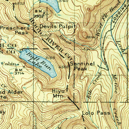
WyEast: Heather, thanks for taking the time to talk about the project, and for all your work in leading this effort. It’s truly a once-in-a-lifetime opportunity, and you’ve really galvanized the community with your vision for protecting this amazing place!

_________________

To view a copy of the Punchbowl Park plan, click here to download a PDF version.

Good News from the Hood River RD!

The Eliot Branch and Mount Hood

The Eliot Branch and Mount Hood

A few weeks ago the Forest Service contacted me about a recent article posted on this blog, It’s Time to Fix the Eliot Crossing!

The article proposed some simple solutions for restoring a washed-out section of the Timberline Trail at the Eliot Branch, which has been offically closed for nearly a decade, and is quite dangerous for those who choose to ignore the closure signs.

The article critiqued Forest Service inaction on the problem, and especially the agency obsession with the “million dollar bridge” solution of somehow installing a supension bridge over the disintegrating canyon of the Eliot Branch. This stream is the unruly outflow from the Mount Hood’s Eliot Glacier, largest of the mountain’s glaciers.

Crossing the Eliot Branch in better days on the old footbridge

Crossing the Eliot Branch in better days on the old footbridge

The proposed susppension bridge would have been prohibitively expensive, and had little chance of ever being funded. Worse, any bridge built here stands a very good chance of being destroyed: the steady retreat of the Eliot Glacier will continue to unravel the canyon below for the foreseeable future as the Eliot Branch carves into new ground once covered by glacial ice.

Because of the critical nature of the article, I expected some grief from the Forest Service. Instead, I learned the Hood River Ranger District has now scrapped its “million dollar bridge” solution and is pursuing a simpler downstream crossing, very similar to what was proposed in the blog article. That’s great news!

The Hood River District staff invited me to meet with them and have a look at their new proposal, so I sat down with one of their Forest Service planners in late December to hear the details. The following are highlights from that conversation.

While they are still in the very early stages of laying out a route, the following map shows the general corridor (in green) the Forest Service has scouted for a “low trail” solution, compared to the new trail concept proposed in the earlier blog article (dashed red):

EliotCrossingRedux03

(Click here for a larger version)

The conceptual Forest Service route would descend the east wall of the Eliot Branch canyon in a series of short switchbacks, just upstream from the ravine where the route was proposed in the blog article.

Once across the Eliot Branch, the Forest Service route would traverse along the ridge that forms the west wall of the canyon, while the route proposed in the blog article followed a tributary stream up a ravine that leads to the Timberline Trail. The Forest Service route is a bit shorter, at 1.2 miles, but follows the same “keep it simple” principles laid out in the blog article.

The Eliot Branch in the vicinity of the proposed crossing (photo © Tim Burke)

The Eliot Branch in the vicinity of the proposed crossing (photo © Tim Burke)

Here’s the best news: the Forest Service hopes to have the new trail under construction in 1-2 years, and have already begun scouting possible alignments. Even better, they hope to involve volunteers in some aspect of the construction, and have reached out to Trailkeepers of Oregon (TKO) to begin that conversation (note: the author is also active in TKO).

This has been a long time coming, and kudos are in order for the Hood River Ranger District for getting this project unstuck — and especially for new staff at the Hood River office who have been instrumental in putting the “million dollar bridge” fiasco behind us. While much more work lies ahead for this project to become a reality, it’s a promising change of direction and a new level of commitment from Forest Service to finally fix this problem.

I’ll post updates on the project here over the next couple of years as the details come into view, of course!

A Mea Culpa is in Order…

When I arrived at the Hood River Ranger District last December for the Timberline Trail meeting, I was surprised to see that the visitor facilities had been dramatically upgraded! This was to my chagrin, as I had lamented the need to do so in this blog article in early 2014. It turns out that the finishing touches to the remodeled Hood River offices were being made at about the time I posted those comments here, so a mea culpa is in order!

Like me, you probably won’t notice the changes to the Hood River Ranger Station when driving by on the Mount Hood Loop Highway, as the public face of the building has been redesigned to face south, not toward the highway to the east. In fact, the building looks much the same from the highway to the casual eye — though an addition to the main building, new signage and an outbuilding have been constructed in what was once a very large parking lot (see below).

Before and after highway views of the ranger station

Before and after highway views of the ranger station

Before and after views of the ranger station

Before and after views of the ranger station

The new orientation makes perfect sense when you stand in front of the building, however. A picturesque view of Mount Hood rising above orchards fills the scene — a view echoed and embraced by the pyramid-shaped wall of windows that define the new visitor center.

Mount Hood fills the southern horizon

Mount Hood fills the southern horizon

The revamped building exterior has ADA-compliant parking and ramps, a small plaza, updated informational sign kiosk, carved welcome sign, bike rack and a new pit toilet. The latter is a much-needed addition that is less elegant than the flush toilets provided at the new Zigzag Ranger Station, but still a nice step forward.

This carved sign welcomes visitors to the new facility

This carved sign welcomes visitors to the new facility

The new visitors center is ADA accessible

The new visitors center is ADA accessible

Once inside the new visitors center, you will find a main desk staffed by a Forest Service ranger, and a nice mix of interpretive displays, ranging from historical artifacts to a collection of mounted wildlife specimens found in the Mount Hood region. The center also has a very good selection of field guides and maps for sale, in addition to many free USFS informational materials.

A nice touch inside the building is a terrestrial telescope mounted on a tripod in front of one of the large picture windows, allowing visitors to take a closer look at the mountain that looms above the ranger station.

Interior panorama of the visitors center (note telescope on the left)

Interior panorama of the visitors center (note telescope on the left)

Rangers staff the new front desk at the visitors center

Rangers staff the new front desk at the visitors center

Watch out… bears lurk behind posts in the new facility!

Watch out… bears lurk behind posts in the new facility!

The wildlife specimens will be fun and informative for families visiting the center, as kids are universally drawn to animal displays. Each mounted display has a detailed info card to help parents become instant experts on the different species represented, or for older kids (and adults) to simply browse and learn from.

Owls on display at the front desk

Owls on display at the front desk

Guard raccoon is on duty 24/7…

Guard raccoon is on duty 24/7…

A particularly menacing bobcat is on display!

A particularly menacing bobcat is on display!

This Pine Marten is in charge of the Bull Trout bumper stickers…

This Pine Marten is in charge of the Bull Trout bumper stickers…

Black bear roaming near the front desk

Black bear roaming near the front desk

The bookstore is located at the west end of the visitor center and creatively designed as a rolling, self-contained portable display. The book offerings are excellent, including many of the most popular regional hiking, climbing, skiing and snowshoeing guides, plus field guides to area flora, fauna and history. Posters and coffee-table books celebrating Mount Hood are also featured.

The rolling bookstore has an excellent cross-section of materials

The rolling bookstore has an excellent cross-section of materials

The map offerings in the rolling bookstore are also excellent, including USFS maps for most National Forests in Oregon and Washington, and official Forest Service maps for wilderness areas in the more immediate Mount Hood region.

The map selection also includes several independently published trail and ski maps, including the exceptional National Geographic Trails Illustrated series for Mount Hood and the Gorge and maps for the Pacific Crest Trail. There are even Green Trails topographic maps for the Mount Hood region (below).

Green Trails topographic maps for sale

Green Trails topographic maps for sale

Historical interpretation is somewhat more limited at the new center, anchored by a fine carved sign (presumably Works Progress Administration or Civilian Conservation Corps?) that once stood at the Cloud Cap junction on the old loop highway. The impressive old sign is flanked with captioned photos of north side history on the mountain.

History displays at the west end of the new facility

History displays at the west end of the new facility

Historic Tilly Jane sign anchoring the history displays

Historic Tilly Jane sign anchoring the history displays

A mounted poster from the Mount Hood Scenic Byway series provides a bit more history of the Cloud Cap Inn and the early climbing history of the north side.

Hopefully, new displays will be added over time to explore more of the rich history of the upper Hood River Valley and north side of Mount Hood: the long Native American history in the area, settlement of the upper Hood River Valley in the 1800s, early Forest Service history on Mount Hood and completion of the Mount Hood Loop Highway in the 1920s are just some of the stories that deserve to be told here.

Mount Hood Scenic Byway history poster

Mount Hood Scenic Byway history poster

There are still some gaps in the visitor experience at the revamped ranger station that could use some attention. First, heavy landscaping hides the Ranger Station from southbound highway traffic (which is how most visitors travel to the mountain), and the signage along the highway is easy to miss. Adding a simple “Visitors Center” sign to the existing entrance marker would be helpful.

Second, the visitor center hours posted at the door differ from what appears on the official Mount Hood Forest website. At least two variations appear on the website, depending where Google takes you: the main website listing shows a M-F schedule, while the dedicated Hood River Ranger District page includes Saturdays in the daily schedule.

The new center elegantly packs a lot into a modest space

The new center elegantly packs a lot into a modest space

The signs at the main entrance to the Ranger Station split the difference, showing M-F hours, but extending to include Saturdays from Memorial Day through Labor Day. In all of these variations, the actual hours are the same: from 8:00 AM to 4:30 PM, closed on all federal holidays.

Obviously, Saturday operating hours are at a premium, both for the Forest Service in covering their expense of keeping the building open, but also for visitors, who are more likely to be traveling here on weekends than weekdays.

Hopefully, the agency can someday find a way to keep the visitors center part of the Ranger Station open on Saturdays (and even Sundays?) year-round. Weekends are undeniably the busiest visitor time on the mountain, and Mount Hood is busy year-round.

Closed mornings, evenings and weekends..?

Closed mornings, evenings and weekends..?

Finally, the pit toilets located outside the new visitor center are currently locked when the visitors center is closed — an unwelcome and unfortunate surprise for travelers who stop early or late in the day, or on weekends.

In the long term, a better way to address the mismatch between federal government hours and those when the public is most likely to be recreating (weekends and holidays) would be to expand the outside informational and interpretive displays to better serve visitors when the main building is closed. This could even include locating interpretive displays some near the pit toilets, and leaving them unlocked on weekends and holidays.

Despite these rough edges, the new visitor center really shines for the Hood River Ranger District. The new facility should greatly enhance the visitor experience for those seeing the area for the first time.

But even if you’re a seasoned Mount Hood hiker, the new center deserves a stop on your next trip through the area. Plan for 20-30 minutes to explore the displays and browse the books and maps.

Finally, a chance to save Punchbowl Falls!

Mount Hood rises in the distance above Punchbowl Falls

Mount Hood rises in the distance above Punchbowl Falls

After nearly 150 years in private ownership, a spectacular basalt gorge along the West Fork Hood River might finally be preserved as a new park. The second of two community meetings on the proposal is rapidly approaching, and is well worth attending if you’re interested in the future of this magnificent place:

Punchbowl Falls Community Workshop
Tuesday, February 10th – 6-7:30 pm
Hood River County Offices
601 State Street, Hood River

If you can’t make the meeting, the county has also set up an online comment forum: click here to complete the survey

About the Proposal

The centerpiece of this exciting proposal is Punchbowl Falls, a cousin to the more famous Punch Bowl Falls on Eagle Creek, in the Columbia Gorge. Both are textbook examples of a “punch bowl” waterfall, pouring into huge, circular bowls carved over the millennia by the upwelling action of the plunging waterfalls. While the more famous Punch Bowl Falls is taller, the Punchbowl Falls on the West Fork is far more powerful, and has carved a much larger amphitheater.

But first, a word about names, as much confusion exists between these waterfall cousins: the lesser-known “Punchbowl” on the West Fork is spelled as one word, while the more famous “Punch Bowl” falls on Eagle Creek uses two words. It’s subtle difference, but important, as these are the official USGS names for the waterfalls, as shown on the maps below:

PunchBowl01

The story of how Punchbowl Falls may finally be preserved for the public began in 2006, when the Western Rivers Conservancy acquired a 20-acre parcel containing the falls from West Fork from Longview Fiber (this is a company that has been aggressively clear-cutting its vast holdings in the upper West Fork watershed over the past decade at an alarming and reckless pace in recent years, so the risk to Punchbowl Falls was real).

The surrounding 82 acres that make up the balance of the Western Rivers property were purchased from Pacificorp in 2010, in tandem with the utility removing its Powerdale Dam, a few miles downstream on the main branch of the Hood River. This purchase includes the beautiful and rugged confluence of the East and West Forks of the Hood River, a powerful spot that remains surprisingly wild and pristine, given the long human presence in this area.

This acquisition marks the beginning of an ambitious effort by the Western Rivers Conservancy to acquire and restore thousands of acres of unprotected West Fork watershed that have been ravaged by relentless logging over the past 130 years, and the eventual restoration of native salmon runs to this beautiful canyon.

Peering into the huge amphitheater at Punchbowl Falls

Peering into the huge amphitheater at Punchbowl Falls

The removal of the dam and consolidation of private land in the spectacular Punchbowl Falls area are huge developments toward the long-term restoration of the Hood River riparian system.

But much work lies ahead, and the most immediate question is whether Hood River County can secure the funds to purchase the 102 acre Punchbowl Falls site from Western Rivers Conservancy for $578,000 — an asking price that is about half the value of the property.

To reach this goal, Hood River County is an application for an Oregon Parks and Recreation (OPRD) grant for purchase of this Punchbowl site. An unsuccessful application was submitted, but failed to win OPRD funding, so in this round the Hood River Valley Residents Committee (HRVRC), a local land-use advocacy group, is sponsoring community outreach activities to help broaden support for the county park proposal.

Early 1900s postcard view of salmon jumping Punchbowl Falls

Early 1900s postcard view of salmon jumping Punchbowl Falls

The area has a long history of recreation as a popular swimming and fishing, which explains why the HRVRC events thus far have had a very strong response: 60 people attended the first community workshop in January, and more than 400 responses have been submitted to the comment website.

Should Hood River County fail to secure state funding for purchase of the site in the near future, the Western River Conservancy is likely to eventually sell the property to another private conservation group, putting future public access in question. While the site has never been more protected from private development, continued public access is now very much at stake.

Early 1900s swimmers cross the falls on a giant old-growth log; note the log bridge in the background where the modern high bridge is now located (Hood River History Museum)

Early 1900s swimmers cross the falls on a giant old-growth log; note the log bridge in the background where the modern high bridge is now located (Hood River History Museum)

It’s apparently common for small communities like Hood River County to win funding on a second try from OPRD for projects like this, so your feedback and support is important in helping make the case to the State of Oregon that Punchbowl Falls and the Hood River confluence deserve to be both protected and forever open to the public as a park.

Please take the time to complete the survey if you can’t make the final county meeting in February: Punchbowl Falls Park Survey

Here’s a map of the proposal from the Hood River County website to familiarize you with the area:

PunchBowl05

Click here for a larger PDF version of the map.

A Virtual Tour of the Site

If you haven’t been to Punchbowl Falls, here’s a brief virtual tour. The visit starts at this unassuming steel gate at a large parking turnout, just before Punchbowl Road crosses a high bridge over the West Fork:

The gate at the Punchbowl Falls trailhead

The gate at the Punchbowl Falls trailhead

A short walk down a rustic service road leads to a maze of informal side paths veering off to the left, toward the imposing rim of the West Fork gorge.

The main attraction here is the massive basalt amphitheater carved by Punchbowl Falls. The walls of the canyon provide some of the best displays of columnar basalt jointing found anywhere in the region. How large is the amphitheater? The scale is hard to appreciate from photos, but Portland’s Memorial Coliseum would fit inside, with headroom to spare!

Looking into the Punchbowl from the east

Looking into the Punchbowl from the east

The curving concrete structure to the right of the falls is a fish ladder constructed in 1957 to improve fish passage (though early photos clearly show fish climbing the falls). A closer look at the fish ladder reveals a dilapidated wooden staircase attached to the basalt columns on the far wall of the canyon. The stairs appear to have been added at the time the fish ladder was constructed:

A rickety staircase descends the west wall of the canyon to the fish ladder

A rickety staircase descends the west wall of the canyon to the fish ladder

An even closer look shows the staircase to be in a serious state of disrepair, and a potentially dangerous hazard to the many swimmers who flock to the Punchbowl in summer:

That last step to the fish ladder is a doozy..!

That last step to the fish ladder is a doozy..!

This is an example of the kind of feedback to include when you comment on the park proposal — for example, simply removing the stairs, and perhaps removing or modifying the fish ladder (below) could help it blend these features with the natural surroundings and make the area safer for visitors.

Downstream view of the fish ladder…

Downstream view of the fish ladder…

….and the upstream view

….and the upstream view

A look downstream from above Punchbowl Falls reveals another waterfall cascading into the gorge from the west. This is the falls on Dead Point Creek, which flows from the high slopes of Mt. Defiance into the Hood River:

Downstream view from above the Punchbowl to Dead Point Falls

Downstream view from above the Punchbowl to Dead Point Falls

The structures above Dead Point Falls are part of a fish hatchery built by the State of Oregon in 1920. The state sold the hatchery at some point in the past, and it is now owned by Troutlodge, a private company that grows and markets fish eggs from several hatcheries in the western states. The hatchery has also been on the market over the past year, but (unfortunately) is not part of the park proposal at this time. Perhaps this could be a second phase of a county park purchase?

Walking downstream along the canyon rim, Dead Point Falls comes into full view. The falls and the canyon wall below the hatchery are fully within the lands owned by the Western Rivers Conservancy, and part of the park proposal:

Dead Point Falls

Dead Point Falls

A closer look at the Dead Point Falls shows a second tier spilling in from the right side. This is the outflow from the hatchery ponds, located behind the buildings that can be seen from the canyon rim, and makes for a unique waterfall:

Dead Point Falls

Dead Point Falls

One of the buildings in the 1920 fish hatchery complex on Dead Point Creek

One of the buildings in the 1920 fish hatchery complex on Dead Point Creek

After visiting a series of waterfall viewpoints along the canyon rim, the network of boot paths curves back to the primitive service road, which descends gently toward the confluence of the West and East Forks of the Hood River — about 1/2 mile downstream from the trailhead.

The confluence is a remarkable place where two powerful rivers collide, creating an enormous gravel bar that makes for a fine lunch spot for taking in the scene. The West Fork enters the confluence at a leisurely pace, emerging from a deep pool between basalt buttresses. The East Fork (shown below) makes a more raucous entrance, roaring around a sharp bend in a series of steep rapids as it tumbles toward the West Fork.

The confluence of the East and West Forks

The confluence of the East and West Forks

The confluence area is fully contained within the Western Rivers Conservancy property, and would be part of a future park. The conservancy holdings include the west (far) wall of the canyon for another mile downstream from this spot, and about the first half-mile of the east wall of the canyon beyond the East Fork is included.

After returning to the trailhead parking area, it’s worth taking a few minutes to walk down Punchbowl Road to the dizzying concrete bridge that spans the upper gorge. There’s plenty of room to safely walk on the bridge, but the side walls are low enough that you’ll want to keep an eye on young kids and pets on a leash.

The dizzying view into Punchbowl Gorge from the bridge

The dizzying view into Punchbowl Gorge from the bridge

From the bridge vantage point, the West Fork corkscrews through a narrow gorge carved into spectacular basalt formations. The gorge area surrounding the bridge is also within the Western Rivers Conservancy holdings, and part of the park proposal.
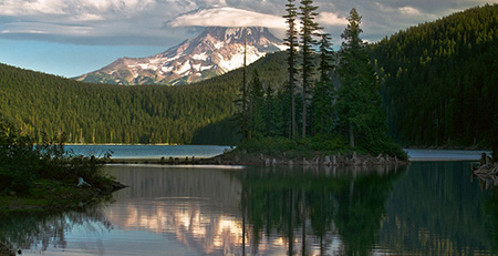
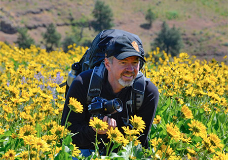
The proposed park site also has trail access in the Winans community, located on the east side of the East Fork, where Iowa Street joins the Dee Highway, north of the Dee junction. This trail is much less traveled than those in the Punchbowl Falls area, and mainly used for fishing access to the area below the confluence.
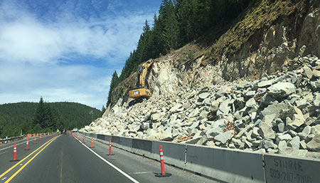
How to find Punchbowl Falls?

If you would like to visit the area after reading this virtual tour, simply follow the Dee Highway from Hood River to the old mill town of Dee, forking to the right and following signs to Lost Lake. Immediately after crossing the East Fork in Dee, head right at a sprawling 3-way intersection, then go straight at another 3-way junction, onto Punchbowl Road. Watch for a large parking area on the right after a short distance, just before the road crosses the high bridge over the Punchbowl gorge.