Lots going on as we enter 2016 in WyEast country, so this article is a bit of a roundup, beginning with yet another commemorative nod from our federal government in the form of…
Columbia River Gorge Priority Mail Express Stamp!

On December 30, 2015 the U.S. Postal Service released another stamp celebrating the Columbia River Gorge, joining the 1992 USPS postcard of the same, classic scene of Crown Point as viewed from Chanticleer Point (Women’s Forum Park).
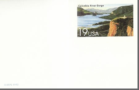
While the 1992 commemorative card was an affordable $0.19, the new Gorge stamp is a hefty $22.95, making for a steep addition to stamp collections! This new Priority Mail Express stamp is available in panes of 10 (for a mere $229.50!), and in the words of the Postal Service, the new stamp “celebrates the grandeur of the Columbia River Gorge” with the following:
Approximately 80 miles long and up to 4,000 ft. deep, the gorge runs along the Columbia River to form part of the border between Oregon and Washington. The stamp art captures the beauty of the Columbia River as it winds its way through the steep cliffs of the Cascade Mountain Range. The historic Vista House sitting atop Crown Point and overlooking the river 725 ft. below shimmers in the golden light of the setting sun.
Illustrator Dan Cosgrove of Chicago worked under the direction of Phil Jordan of Falls Church, VA, to create the stamp image.
The artists captured a faithful rendering of the scene, but I can’t help but wonder why a local illustrator wasn’t selected? After all, the Portland region is home to so many, including Paul A. Lanquist (PAL), the creative force behind dozens of “new retro” posters of Pacific Northwest scenes, like this view of Vista House:

Courtesy: Discover the Northwest
So, save your money on that spendy USPS stamp and consider supporting a Northwest artist, instead. You can find Paul Lanquist’s posters at Discover the Northwest and many other outlets.
Still Creek Trails
As part of a recent series of articles on the Mirror Lake backcountry and Wind Creek Basin, I proposed the following concept for eventually expanding trails in this pocket wilderness:

(click here for large map)
After posting these articles, I happened to be researching the area for a related topic and was surprised to find many of my “proposed” trails on early maps. I’m going to chalk that up as “imitation being the sincerest form of flattery” as I’m sure I’ve studied these maps before, and must have noticed these earlier trails! Or so it would seem?
Nonetheless, it was a pleasant (re)surprise to discover that we once had a hefty trail network here, as it helps make the case for bringing more trails in this area to reality someday. Past is prologue! And who knows, maybe some of these old treads still survive?
(click here for large map)
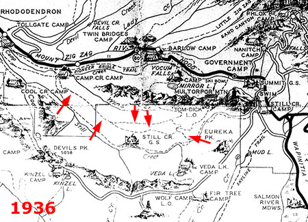
A closer look at the 1937 forest map (above, marked with red arrows) reveals a rim trail that followed the north side of Still Creek valley from Camp Creek to – what’s that? – a trail between Still Creek and Mirror Lake!
These old trails show up on a more “official” 1939 forest map (below), with added detail showing the connector to Still Creek continuing south to (what still exists today as) the Eureka Peak trail. This explains what has always been an odd trail fragment at Eureka Peak and raises the intriguing question of whether the segment north of Still Creek to Wind Lake and beyond still exists?

(click here for large map)
These old routes persist on forest maps dating into the late 1940s, when the commercial logging assault on our forests began wiping out hundreds of miles of old trails (below).

(click here for large map)
But Mirror Lake, the Wind Creek Basin and Still Creek valley were still recovering from the catastrophic Sherar Burn when the logging bonanza took off in the mid-1900s, and were mostly spared from clear cutting and logging roads. That not only gave today’s pocket wilderness, but it also bodes well for traces of these old trails to still survive – and someday be rediscovered and restored, perhaps?
Eliot Crossing Update
Lots of news on the Eliot Crossing proposal, first described in this WyEast Blog article from 2014. As reported earlier, the Forest Service is moving a trail project forward this year that will finally restore the missing section of the Timberline Trail at the Eliot Branch crossing.
The following map originally appeared in this blog, but later became a Trailkeepers of Oregon (TKO) map for the purpose of the Eliot Crossing project, and now is being shared with the Forest Service, as well:

(click here for large map)
In January, Claire Pitner, Forest Service project manager for the new trail at the Hood River Ranger District, sent this good news to local non-profits involved in the project:
“I wanted to let you know that the environmental analysis for the Eliot Reroute was signed yesterday. Furthermore, earlier this week we received word that the Regional Office is providing funding to complete the project. Much of the work will be done using a contractor with volunteer assistance as well.
“We are working on finalizing the contract package in hopes of having a contractor long before we are able to access and do work at the site. I’m looking forward to working with TrailKeepers to get some good work done this summer!”
By early February, the local media picked up on the story with (surprise!) mentions of the WyEast Blog in The Oregonian and Willamette Week – a nice plug for the blog and the Eliot Crossing project!
In early March, the TKO board will be meeting with the Forest Service and several other non-profit organizations to begin planning volunteer activities related to the project. It should be a fun, family-friendly opportunity for volunteers to be part of the project, and I’ll post updates on the project as more details become available.
LG TV Mystery Mountain Ad
I’ll end the roundup on a whimsical note, courtesy LG, the electronics giant. I spotted the following print ad over the holidays and something about it looked too familiar – as it should have. This is our very own Trillium Lake…

Do not attempt to adjust your television…
…except it isn’t, unless you’re looking in the rear-view mirror of your kayak (or canoe). A closer look at the mountain (below) shows all the major features of WyEast reversed, with a misplaced White River glacier flowing down the southwest slope of the mountain (imagine the mayhem in Rhododendron!), and poor Illumination Rock and Mississippi Head rudely moved to the east side of the mountain:
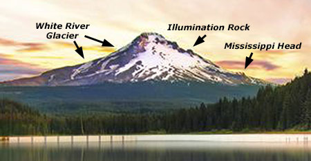
This looks vaguely familiar…
But the really goofy part of this ad is the appearance of what seems to be an Italian (Burano?) or perhaps Icelandic fishing village teleported to the Oregon Cascades:

Preview of a future Forest Service concession..?
As always, it’s good to see our mountain (and Gorge) making regular appearances in print media from around the world, even if the graphic artists can’t resist making a few improvements. Even with the artistic tinkering, these ads underscore the world-class nature of these amazing places… and their national park-worthiness, of course!

Looking at old maps certainly makes me sad for all the trails we’ve lost. The Gifford-Pinchot Forest is even worse. There were some very spectacular waterfalls that you could hike to 80 years ago that now are only for scramblers and bushwackers. Just recently, we lost Big Creek Falls there. The usual excuse is no money for trail maintenance. I don’t think it was just logging roads taking trails out. In lots of places there was no logging but the trails still were let go. It isn’t like there are less hikers now than 80 years ago. Quite the reverse.
LikeLike