Mount Hood rises in the distance above Punchbowl Falls
After nearly 150 years in private ownership, a spectacular basalt gorge along the West Fork Hood River might finally be preserved as a new park. The second of two community meetings on the proposal is rapidly approaching, and is well worth attending if you’re interested in the future of this magnificent place:
Punchbowl Falls Community Workshop
Tuesday, February 10th – 6-7:30 pm
Hood River County Offices
601 State Street, Hood River
If you can’t make the meeting, the county has also set up an online comment forum: click here to complete the survey
About the Proposal
The centerpiece of this exciting proposal is Punchbowl Falls, a cousin to the more famous Punch Bowl Falls on Eagle Creek, in the Columbia Gorge. Both are textbook examples of a “punch bowl” waterfall, pouring into huge, circular bowls carved over the millennia by the upwelling action of the plunging waterfalls. While the more famous Punch Bowl Falls is taller, the Punchbowl Falls on the West Fork is far more powerful, and has carved a much larger amphitheater.
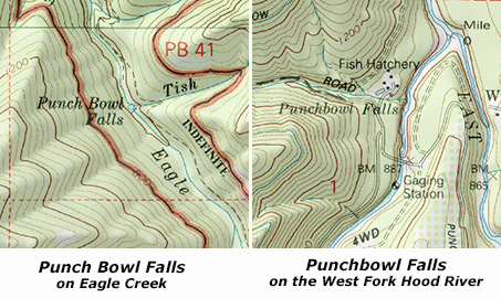
But first, a word about names, as much confusion exists between these waterfall cousins: the lesser-known “Punchbowl” on the West Fork is spelled as one word, while the more famous “Punch Bowl” falls on Eagle Creek uses two words. It’s subtle difference, but important, as these are the official USGS names for the waterfalls, as shown on the maps below:
The story of how Punchbowl Falls may finally be preserved for the public began in 2006, when the Western Rivers Conservancy acquired a 20-acre parcel containing the falls from West Fork from Longview Fiber (this is a company that has been aggressively clear-cutting its vast holdings in the upper West Fork watershed over the past decade at an alarming and reckless pace in recent years, so the risk to Punchbowl Falls was real).
The surrounding 82 acres that make up the balance of the Western Rivers property were purchased from Pacificorp in 2010, in tandem with the utility removing its Powerdale Dam, a few miles downstream on the main branch of the Hood River. This purchase includes the beautiful and rugged confluence of the East and West Forks of the Hood River, a powerful spot that remains surprisingly wild and pristine, given the long human presence in this area.
This acquisition marks the beginning of an ambitious effort by the Western Rivers Conservancy to acquire and restore thousands of acres of unprotected West Fork watershed that have been ravaged by relentless logging over the past 130 years, and the eventual restoration of native salmon runs to this beautiful canyon.
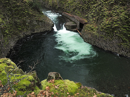
Peering into the huge amphitheater at Punchbowl Falls
The removal of the dam and consolidation of private land in the spectacular Punchbowl Falls area are huge developments toward the long-term restoration of the Hood River riparian system.
But much work lies ahead, and the most immediate question is whether Hood River County can secure the funds to purchase the 102 acre Punchbowl Falls site from Western Rivers Conservancy for $578,000 — an asking price that is about half the value of the property.
To reach this goal, Hood River County is an application for an Oregon Parks and Recreation (OPRD) grant for purchase of this Punchbowl site. An unsuccessful application was submitted, but failed to win OPRD funding, so in this round the Hood River Valley Residents Committee (HRVRC), a local land-use advocacy group, is sponsoring community outreach activities to help broaden support for the county park proposal.
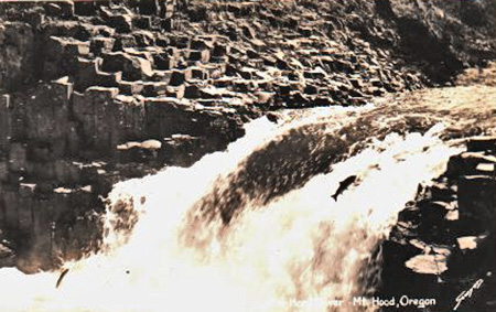
Early 1900s postcard view of salmon jumping Punchbowl Falls
The area has a long history of recreation as a popular swimming and fishing, which explains why the HRVRC events thus far have had a very strong response: 60 people attended the first community workshop in January, and more than 400 responses have been submitted to the comment website.
Should Hood River County fail to secure state funding for purchase of the site in the near future, the Western River Conservancy is likely to eventually sell the property to another private conservation group, putting future public access in question. While the site has never been more protected from private development, continued public access is now very much at stake.
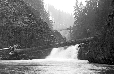
Early 1900s swimmers cross the falls on a giant old-growth log; note the log bridge in the background where the modern high bridge is now located (Hood River History Museum)
It’s apparently common for small communities like Hood River County to win funding on a second try from OPRD for projects like this, so your feedback and support is important in helping make the case to the State of Oregon that Punchbowl Falls and the Hood River confluence deserve to be both protected and forever open to the public as a park.
Please take the time to complete the survey if you can’t make the final county meeting in February: Punchbowl Falls Park Survey
Here’s a map of the proposal from the Hood River County website to familiarize you with the area:
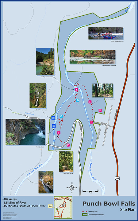
Click here for a larger PDF version of the map.
A Virtual Tour of the Site
If you haven’t been to Punchbowl Falls, here’s a brief virtual tour. The visit starts at this unassuming steel gate at a large parking turnout, just before Punchbowl Road crosses a high bridge over the West Fork:
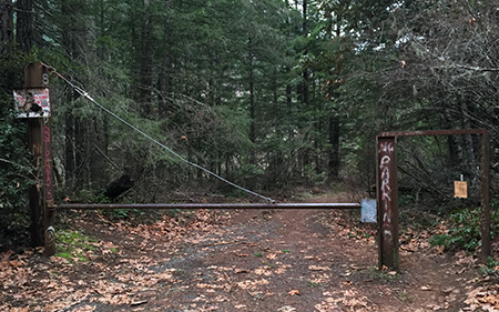
The gate at the Punchbowl Falls trailhead
A short walk down a rustic service road leads to a maze of informal side paths veering off to the left, toward the imposing rim of the West Fork gorge.
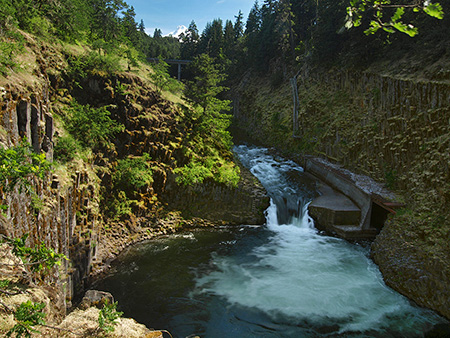
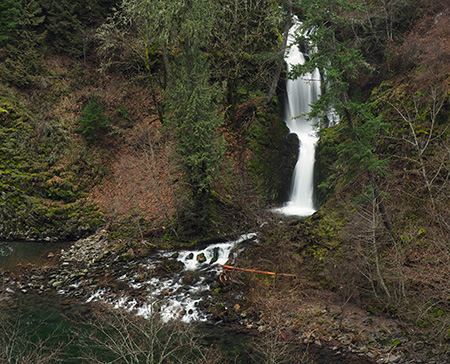
The main attraction here is the massive basalt amphitheater carved by Punchbowl Falls. The walls of the canyon provide some of the best displays of columnar basalt jointing found anywhere in the region. How large is the amphitheater? The scale is hard to appreciate from photos, but Portland’s Memorial Coliseum would fit inside, with headroom to spare!
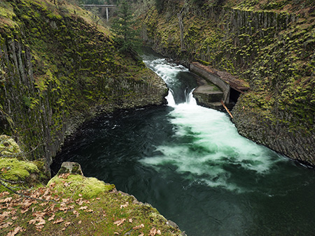
Looking into the Punchbowl from the east
The curving concrete structure to the right of the falls is a fish ladder constructed in 1957 to improve fish passage (though early photos clearly show fish climbing the falls). A closer look at the fish ladder reveals a dilapidated wooden staircase attached to the basalt columns on the far wall of the canyon. The stairs appear to have been added at the time the fish ladder was constructed:
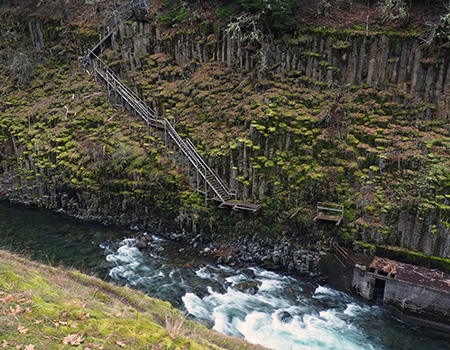
A rickety staircase descends the west wall of the canyon to the fish ladder
An even closer look shows the staircase to be in a serious state of disrepair, and a potentially dangerous hazard to the many swimmers who flock to the Punchbowl in summer:
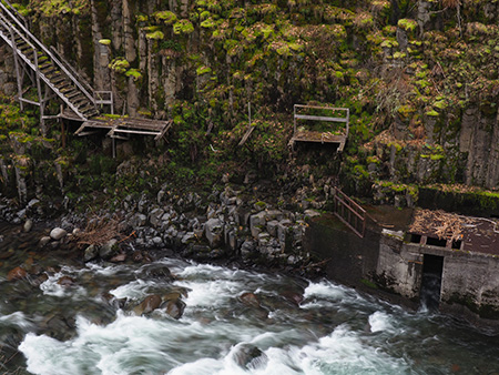
That last step to the fish ladder is a doozy..!
This is an example of the kind of feedback to include when you comment on the park proposal — for example, simply removing the stairs, and perhaps removing or modifying the fish ladder (below) could help it blend these features with the natural surroundings and make the area safer for visitors.

Downstream view of the fish ladder…
….and the upstream view
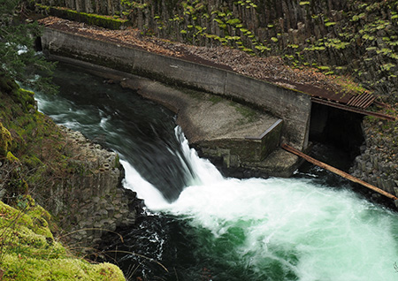
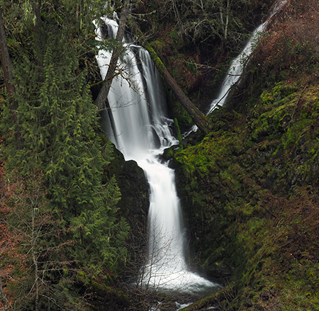
A look downstream from above Punchbowl Falls reveals another waterfall cascading into the gorge from the west. This is the falls on Dead Point Creek, which flows from the high slopes of Mt. Defiance into the Hood River:
Downstream view from above the Punchbowl to Dead Point Falls
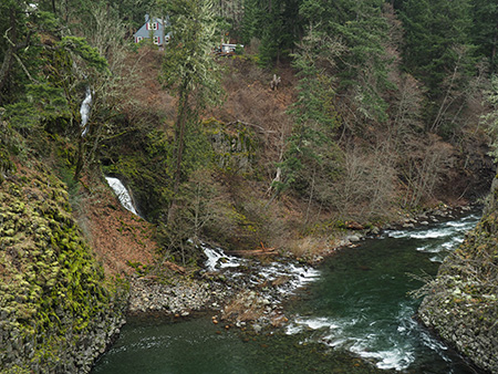
The structures above Dead Point Falls are part of a fish hatchery built by the State of Oregon in 1920. The state sold the hatchery at some point in the past, and it is now owned by Troutlodge, a private company that grows and markets fish eggs from several hatcheries in the western states. The hatchery has also been on the market over the past year, but (unfortunately) is not part of the park proposal at this time. Perhaps this could be a second phase of a county park purchase?
Walking downstream along the canyon rim, Dead Point Falls comes into full view. The falls and the canyon wall below the hatchery are fully within the lands owned by the Western Rivers Conservancy, and part of the park proposal:
Dead Point Falls
A closer look at the Dead Point Falls shows a second tier spilling in from the right side. This is the outflow from the hatchery ponds, located behind the buildings that can be seen from the canyon rim, and makes for a unique waterfall:
Dead Point Falls
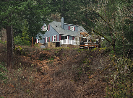
One of the buildings in the 1920 fish hatchery complex on Dead Point Creek
After visiting a series of waterfall viewpoints along the canyon rim, the network of boot paths curves back to the primitive service road, which descends gently toward the confluence of the West and East Forks of the Hood River — about 1/2 mile downstream from the trailhead.
The confluence is a remarkable place where two powerful rivers collide, creating an enormous gravel bar that makes for a fine lunch spot for taking in the scene. The West Fork enters the confluence at a leisurely pace, emerging from a deep pool between basalt buttresses. The East Fork (shown below) makes a more raucous entrance, roaring around a sharp bend in a series of steep rapids as it tumbles toward the West Fork.
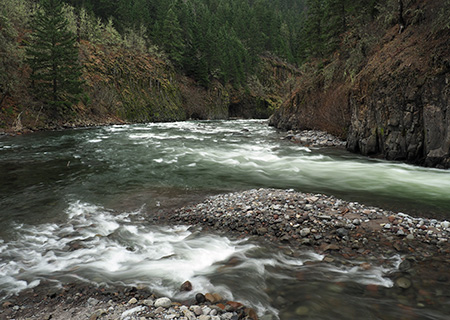
The confluence of the East and West Forks
The confluence area is fully contained within the Western Rivers Conservancy property, and would be part of a future park. The conservancy holdings include the west (far) wall of the canyon for another mile downstream from this spot, and about the first half-mile of the east wall of the canyon beyond the East Fork is included.
After returning to the trailhead parking area, it’s worth taking a few minutes to walk down Punchbowl Road to the dizzying concrete bridge that spans the upper gorge. There’s plenty of room to safely walk on the bridge, but the side walls are low enough that you’ll want to keep an eye on young kids and pets on a leash.

The dizzying view into Punchbowl Gorge from the bridge
From the bridge vantage point, the West Fork corkscrews through a narrow gorge carved into spectacular basalt formations. The gorge area surrounding the bridge is also within the Western Rivers Conservancy holdings, and part of the park proposal.
The proposed park site also has trail access in the Winans community, located on the east side of the East Fork, where Iowa Street joins the Dee Highway, north of the Dee junction. This trail is much less traveled than those in the Punchbowl Falls area, and mainly used for fishing access to the area below the confluence.
How to find Punchbowl Falls?
If you would like to visit the area after reading this virtual tour, simply follow the Dee Highway from Hood River to the old mill town of Dee, forking to the right and following signs to Lost Lake. Immediately after crossing the East Fork in Dee, head right at a sprawling 3-way intersection, then go straight at another 3-way junction, onto Punchbowl Road. Watch for a large parking area on the right after a short distance, just before the road crosses the high bridge over the Punchbowl gorge.

Funny you go through the trouble to differentiate “Punch Bowl” from “Punchbowl”, and it’s wrong on the map.
LikeLike
Well, that was kind of the idea! Hoping to clear that up a bit… 🙂
LikeLike
For clarification, the gray house you pictured was originally part of the State of Oregon fish hatchery. We purchased the house in 1975 when the State of Oregon sub-divided the property. It has not been a part of the fish hatchery since and is privately owned by us. It is not part of the Troutlodge property and is not for sale. The majority of the property owned by Troutlodge has no view of the Punchbowl.
Jon and Zoe Purnell
LikeLike
Thanks for commenting and clarifying that point, Jon & Zoe – and for taking care of your historic home!
LikeLike