
The view from Raker Point in a 1930s postcard
Each year, thousands visit beautiful Lost Lake, one of the most beautiful and iconic places in Mount Hood country. The view of Mount Hood mirrored in the lake has been photographed countless times and has graced hundreds of postcards, calendars and scenic books. Some visitors to the lake climb the old lookout trail to Lost Lake Butte, which provides a sweeping view of the mountain, but only glimpses of the lake as once-burned forests continue to recover there.
Yet, not long ago, another dramatic view was possible: Lost Lake nestled in the forests beneath Mount Hood, framed with blooming Pacific Rhododendrons. This scene was captured from the crest of Raker Point, a rocky spur due north of Lost Lake, and briefly a forest lookout site in the early 1930s.

The view from Raker Point as captured in a Ray Atkeson postcard in the late 1940s
The view from Raker Point appeared in early postcards, and was later captured by Oregon’s famed photographer Ray Atkeson (above) in images that appeared widely in calendars, postcards and even automobile ads (below) in the 1950s.
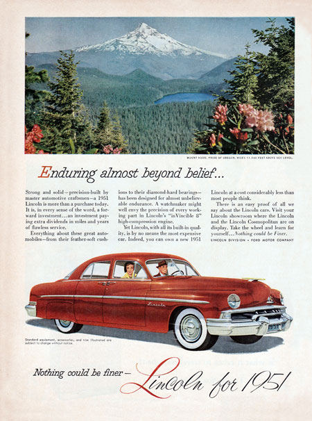
1951 Lincoln ad featuring the view from Raker Point
Ironically, the famous images captured by Atkeson were made possible by the industrial logging that began sweeping our national forests in the decades following World War II. By the late 1940s, a logging spur pushed over the saddle between Sawtooth Ridge and Raker Point, providing easy access to the spectacular view, even as it enabled the destruction of old growth forests that once grew there.
Today, the old logging road to Raker Point has been decommissioned by the Forest Service and the clearcut slopes are slowly recovering. Now, Raker Point has become all but forgotten.
Where is Raker Point?
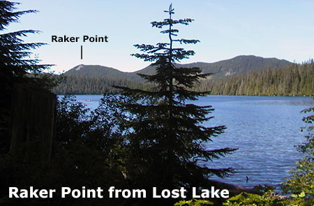
Raker Point isn’t the tallest or most impressive among the Cascade peaks that rise up around Lost Lake, but it is the best positioned for a grand view of the lake and Mount Hood. Raker Point can be seen from the Lakeshore Trail, where it rounds the south end of the lake, as shown above.
When the Forest Service first brought a road to Lost Lake and lookout towers to the Lost Lake area in the 1920s and early 1930s, Raker Point was much more prominent, thanks to wildfires in the early 1900s that had cleared both Raker Point and Lost Lake Butte. Their open summits made ideal forest lookout sites.
This early 1930s view shows Raker Point and other nearby peaks from Hiyu Mountain, another lookout site located several miles to the south, and Raker Point’s bald summit clearly stands out:

[click here for a larger image]
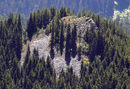
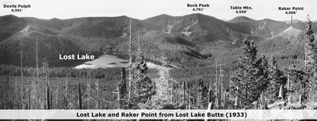
A closer 1933 view from nearby Lost Lake Butte in 1933 shows the scorched summit of Raker Point much more clearly. The impressive old growth forests of the Lost Lake Basin are also on display in this view:

Scorched Raker Point from Lost Lake Butte in the early 1930s
This rare 1933 perspective of Raker Point and Lost Lake is from Sawtooth Ridge, where a temporary (and misnamed) “Raker Point” lookout was briefly located:

[click here for a larger panorama]
The origin of Raker Point’s name is unclear, but it’s likely that an early Forest Service ranger or surveyor named the peak — and perhaps was the namesake, too?
Today, forests have returned to all but the rocky summit and surrounding talus slopes on Raker Point. This view (below) from the Lake Branch Road shows the now green slopes, with just a small opening near the top of the butte. Does this mean the classic view of Lost Lake and Mount Hood captured by Ray Atkeson in the 1940s has been lost?

Raker Point rises above the talus fields along the Lake Branch Road
The answer can be found on the opposite side of Raker Point. This view from Indian Mountain, located a few miles north and across the Lake Branch Valley from Raker Point, shows the still open, rocky crest framed in talus slopes and groves of Noble Fir:
The rocky crest of Raker Point from the north, as viewed from Indian Mountain
While rhododendrons may not thrive on the summit, the views of Mount Hood and Lost Lake are clearly still intact, though probably framed in Noble fir boughs and drifts of huckleberries.
The Proposal
The Lost Lake area already has a fine network of trails, but a new route to Raker Point would bring needed opportunities to this popular recreation area.
First, the classic view from Raker Point is reason enough to warrant trail access to the summit. But a trail to Raker Point would also serve as a more attainable challenge for families visiting Lost Lake.
Today, hikers can make the 2-mile trek to the summit of Lost Lake Butte. Yet, while the view from there is excellent, it pales in comparison to Raker Point. More importantly, a trail to Raker Point would shave 400 feet of elevation gain in half the distance compared to the Lost Lake Butte hike, making it much more accessible to casual hikers and families with young children.
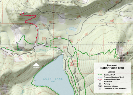
[click here for a large map]
The proposed trail is simple: it would begin along a segment of the Old Skyline Trail that traverses the base of the Raker Point, and connects to the nearby campground, resort cabins and lodge at Lost Lake.
Trail building would be straightforward, as well. The area is outside protected wilderness, so would not present limitations on the use of power saws and or other heavy equipment in the construction. The modest 1-mile length of the proposed new trail also puts it within financial reach in this era of cash-strapped federal land agencies.
[click here for a large panorama]
The new trail would also be accessible from trailheads along the Lake Branch Road, allowing hikers to visit the trail without adding to the crowds and congestion at Lost Lake, proper.
What would it take to make this happen? Interest from Forest Service officials, for sure, but support from the Lost Lake Resort operators, in particular, could put this new trail on a fast track. The resort would clearly benefit from a new family-friendly trail option near the lodge, and would be powerful advocates if they were to bring this argument to the Forest Service.
So, consider mentioning the idea if you happen to visit the resort this summer..!
__________________________
Postscript: at about the time I was writing this article, uber-adventurer Paul Turner was exploring Raker Point and nearby Sawtooth Ridge. He posted some excellent photos from his trip over here on the Oregon Hikers forum. Thanks, Paul!

Great post Tom. Do you think you would also be able to see Mt St Helens from the summit? Like the view from the Hiyu picture. Or is is too low? (obviously Mt St Helens is a bit lower than it was in that photo too)
LikeLiked by 1 person
Thanks, Brian! Yes, I think it’s probably too low — by about 500 feet.
LikeLike
Mr. Kloster,
Once again, a very detailed and informative post, sharing history of the area and suggesting practical solutions for increased recreation in the Mt. Hood/Columbia Gorge region. Thank you!
LikeLiked by 1 person
Once again I had no interest in the topic of your post, but read it anyway because I knew I’d get fresh insights into the history of our region, and enjoy a well-reasoned and thoroughly documented argument in support of the public good. And once again, I was not disappointed in the least.
LikeLiked by 1 person
Thank you for taking the time to read the blog, Jim & Joel! Much appreciated! 🙂
LikeLike
Love the blog. I live up Lolo Pass Rd., and spend alot of time on that side of the pass. So very interesting learning the history you share, seeing the images, and pondering the potential for the future!
LikeLiked by 1 person