These venerable steel towers will soon be a memory in the Gorge
Author’s preface: having spent more than 30 years in public service, it frustrates me to see any level of government making anything less than a consistent, substantial and meaningful effort to engage the broader public in its decision making. All public entities should be held to this high standard, whether local, state or federal.
So, when I stumbled across the Bonneville Power Association (BPA) decision to significantly rebuild the prominent power line corridor that links Bonneville Dam to Hood River, I was disappointed to learn that the decision involved a handful of select stakeholders and two short windows for public comment that saw little notice or participation. We should expect more, and the BPA should step up its commitment to real public engagement, not meager efforts that do little more than check regulatory boxes.
_______________
According to a retired BPA employee who once joined me on a hike near Starvation Creek, the daring alignment of the power line corridor that provided the first electricity from Bonneville Dam to Hood River is the doing of no less than Franklin D. Roosevelt. As the story goes, FDR was on his famous tour of the Mount Hood Loop Highway on September 28, 1937, with stops to inspect Bonneville Dam and dedicate Timberline Lodge.
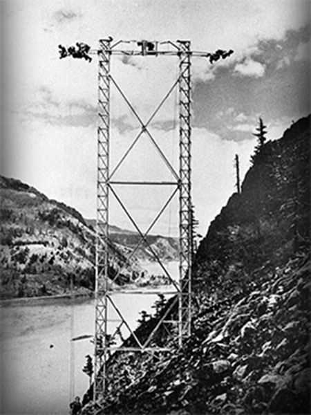
BPA workers building the daring new power lines across Shellrock Mountain in 1937 (BPA)
After leaving Bonneville, FDR asked about the power lines that were under construction, and a BPA official told the president they would be built on slopes high above the Gorge, where the terrain was easier to navigate. FDR reportedly barked at the official “I want those power lines down here, where the people can see the electricity that we’re bringing to their communities!”
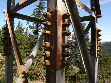
So began the project to build the BPA power lines across the rugged cliff faces of the Columbia River Gorge. Amazingly, most of the work was done by hand, with pack mules carrying materials to the often dizzying cliff-top tower locations. While it’s hard to view any power line as “scenic”, the sheer audacity in how these towers were designed and built can’t help but impress hikers passing under them today.
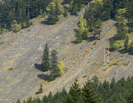
The Shellrock Mountain power line and trail today
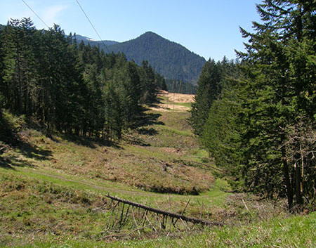
The Bonneville to Hood River corridor is one among many power lines that transmit hydro-power along the Columbia, but this corridor is notable in that much of it is serviced through a network of trails where the terrain was too extreme to support service roads. Many of these trails have morphed into recreation trails over the years.
Big Changes Coming this Summer
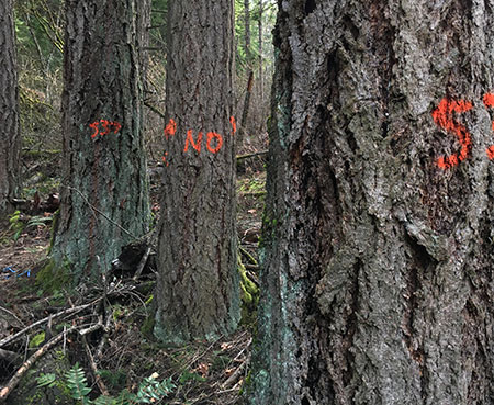
Trees marked for cutting at Viento State Park
After eighty years of maintaining the Gorge power line corridor in much the same state, the BPA is about to significantly change both the look of the towers and some of the access routes. I stumbled across this reality earlier this spring when I was exploring the area above Viento State Park, where I encountered a few dozen mature Douglas fir marked for cutting.
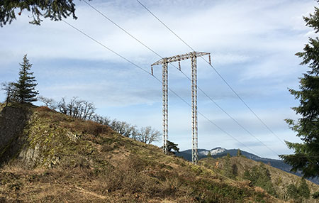
At first, I thought it might be a thinning project of some sort, but upon some research, discovered that the BPA was about to replace all of the steel towers and many of the wood pole towers along the corridor and expand several of the access spur roads. Up to 30 of the new towers will be steel “mono-poles”, a departure in both look and height from somewhat rustic old structures that now exist on the corridor.
The project also proposes to remove up to 747 trees to allow access roads to be widened and rebuilt, and the BPA proposes “temporary disturbance” to over 58 acres and “permanent disturbance” to about one-third of an acre.
More trees marked for cutting in the Gorge power line corridor
For the scoping phase of this project, the BPA opened a public comment period of six weeks and held a public meeting in Hood River in the spring of 2014. They received 12 written comments during the scoping phase and four people attended this meeting. Sadly, this dismal turnout was during the critical window for raising issues to be considered by the BPA as part of the environmental assessment.
The agency also reached out to tribes and a few interest groups they have long engaged in their public outreach, but their effort falls short of a meaningful commitment to fully engage the public, as evidenced by the meager input they received. The BPA held a second public meeting and opened a final six-week comment period on the draft environmental assessment last fall. As one of the largest and most reliably funded public agencies in existence, the BPA can and should do better.
Who Weighed in?
The BPA’s overly aggressive removal of native vegetation in the power line corridor and subsequent abundance of invasive species was a theme in comments received
While the BPA received very little input from their limited effort to reach out to the public, there were a few commenters. The Friends of the Columbia River Gorge were one again our reliable and invaluable watchdogs in the Gorge weighed in with extensive comments, including the following on the BPA proposal:
[The BPA should] mitigate scenic impacts by installing new structures that would be less visually discordant in the landscape. Where steel towers are needed, we ask that weathering steel be employed to reduce visibility.
Include a robust invasive species eradication and restoration strategy. The BPA transmission line corridor is frequently infested with invasive plants, such as Armenian blackberry. While replacing structures, BPA should remove invasive plants and restore native vegetation communities that would be compatible with long-term vegetation management requirements.
BPA should also thoroughly document existing native vegetation communities and determine the need for future vegetation management. BPA’s past vegetation removal efforts have removed vegetation that poses no threat to the transmission line system, which unnecessarily harms wildlife habitat and creates openings for invasive plants.
The Pacific Crest Trail Association also weighed in, with concerns about how the proposed changes could degrade the PCT where the power line crosses the trail near the Bridge of the Gods trailhead. Among their concerns:
The existing view from the trail is a long line of sight down a decidedly unnatural appearing power line corridor, crisscrossed with roads. Forest Service scenery management principles dictate that developments viewed from a sensitive viewing area should strive to mimic “the form, line, color, texture, and pattern common to the landscape.”
Contrary to this, the improved roads will stand out visually as artificial, in what’s already an artificial corridor of cleared vegetation. The improvements would disrupt the PCT traveler’s experience because they clearly mark human manipulation and diminish the desired sense of remoteness from civilization.
While it’s suboptimal for the PCT to follow any road at all, at least the existing condition of the road is rustic. Upgrades to the road, including resurfacing with imported materials, will make it appear and feel more industrialized for the PCT traveler. A related effect, because the road is already dominant over the trail, is that people get lost and continue to follow the road, despite trail signage. Improving the road would exacerbate this situation.
The trail crosses directly under one of the structures, in fact, between the poles and their guy lines. This site can’t help but appear impacted by the proposed improvements. There will be three poles instead of two, and, clearly a good deal of ground disturbance involved in upgrading this structure.
These exacerbated visual impacts to the trail could be best ameliorated by reconfiguring the intersection, and reconstructing portions of the PCT where necessary to meet the BPA line in a spot that lends itself better to disguise. Such a trail relocation would be as much as .5 mile long, and would require its own NEPA study. We propose that this NEPA study, and subsequent trail construction by PCTA’s volunteer crews, be funded by BPA as a mitigation measure.
The Columbia River Gorge National Scenic Area (CRGNSA) unit of the U.S. Forest Service wrote extensive comments, mostly reminding the BPA of regulatory requirements related to the Gorge and the need to conduct environmental assessments when trails or other recreation facilities within the corridor would be significantly impact. The CRGNSA did not comment on opportunities to improve the access trails along the corridor to serve as recreational trails.
What to Expect this Summer?
This project is now going forward in largely the form that was first proposed in 2014 as the preferred action by the BPA. What does this mean for your favorite trails in the Gorge? Here’s are some key excerpts from the BPA’s 410-page draft environmental assessment, beginning with a project overview:
“The Proposed Action is to: (1) rebuild portions of the Bonneville-Hood River transmission line within the rebuild area for the Project (the 22-mile-long segment from structure 1/5 to the Hood River Substation); (2) rebuild the Cascade Locks Tap [author’s note: this is the point where the community of Cascade Locks taps into the power line corridor]; and (3) improve and extend the access road and trail system that allows BPA access to and from the transmission line. Specifically, the Proposed Action would involve the following components:
- Removal of wood-pole and lattice-steel H-frame transmission line structures constructed prior to 1999 (including cross arms, insulators, hardware, and guy wires) and replacement with a combination of wood-pole H-frame structures and steel-monopole structures.
- Retirement of unnecessary transmission line structures.
- Replacements of conductors and guy wires.
- Replacement of insulators and hardware in locations with no structure or conductor replacement.
- Improvement, reconstruction, and extension of existing access roads and trails.
- Installation or replacement of bridges, fords, culverts, and access road gates.
- Establishment of temporary staging areas, helicopter flight yards, and tensioning sites (for pulling and tensioning conductors).
- Installation of temporary guard structures for stringing lines over roads and other utilities.
- Removal of vegetation at various locations along the transmission line right-of-way and access roads.
- Re-vegetation of areas disturbed by construction activities.
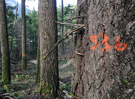
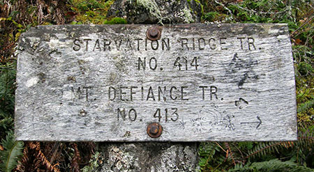
Hikers are mostly likely to notice the changes on trails that also serve as access to the power lines or cross the corridor, including the Pacific Crest Trail, Starvation Ridge, Mount Defiance, Wygant and Mitchell Point trails. Off-trail explorers will also see changes in the bluffs above Viento State Park and on Shellrock Mountain.
The Mount Defiance and Starvation Ridge Trails could be noticeably affected where they pass through the power line corridor
Here’s an except from the environmental assessment that describes the changes we will likely see in these places:
“BPA currently uses a combination of existing roads and foot trails to access the transmission line. BPA holds permits and access road and foot trail easements for access across public and private land. Through these permits and easements, BPA has previously constructed roads and foot trails to access the transmission line. These access roads and foot trails are primarily located within the transmission line right-of-way, but there are also some access roads and foot trails located outside the right-of-way where required due to terrain constraints or other factors.
In a few locations, BPA currently does not have express easement rights to use some existing roads or foot trails that provide access to the transmission line. At these locations, BPA would acquire about 4.4 miles of easement rights to use various sections of the existing roads and trails. Generally, BPA obtains a 50-foot-wide easement for access road rights and 20-foot-wide easements for foot trails.
BPA’s existing access roads for the line are typically 14 feet wide with an additional 3-foot offset from each side for slopes or drainage ditches, resulting in a total disturbance width of about 20 feet. Access road reconstruction and improvement activities associated with the Proposed Action would occur within this prism, except in areas with curves or on steep slopes where work would occur outside of this prism because of necessary cut and fill.
In areas with identified sensitive resources, such as wetlands or sensitive habitat, access road widths would be reduced to 12 feet and the offsets on either side would be reduced to 2 feet, for a total area of disturbance of 16 feet to minimize temporary and permanent impacts.
Trail reconstruction or extension activities would result in a typical trail bed width of 18 inches that would require a total clearing area of 2 to 4 feet. For trails crossing steep talus areas, such as Shellrock Mountain, trail bed widths may be as small as 12 inches due terrain constraints. To provide trail stability in these steep areas, sideboards would be installed with rebar or rocks would be keyed into the hill.
On talus slopes, the trail bed would be comprised of compacted course surface material. In non-talus areas, the trail bed would be at grade and would consist of native material. All trail work areas would be accessed by foot and trail improvement, reconstruction, or extension work would be conducted with hand held equipment.”
More information on the project can be found on the BPA’s project website.
It’s never to late to be heard…
BPA power line tower to be replaced on the Viento Bluffs
With a little more effort in their public outreach (like contacting trail organizations), the BPA would certainly have heard plenty of comments from the general public, and especially from hikers who regularly visit the corridor. Much of the commentary would likely have focused on how popular trails like Starvation Ridge and Mount Defiance will be impacted by the project.
But it could also have been an opportunity for hikers to propose expanded use of the power line trails by hikers, including areas like Shellrock Mountain and the area between Starvation Creek and Viento Creek that have tremendous scenic value. While the Forest Service declined to call out this opportunity, these trail sections also could help complete Gorge Trail 400.
No doubt the BPA wouldn’t be enthusiastic about bringing more hikers to the corridor, but the land belongs to the public and there’s no reason not to make full use of the routes the BPA will be building and maintaining with our public funds.
The BPA corridor crossing Shellrock Mountain (BPA)
Is it too late to weigh in? Yes, for the most part. The project entered the final stage of the environmental impact process this spring and is scheduled to move into construction this summer. But if you’re concerned about how the construction is proceeding on the ground, you can contact the BPA directly with your concerns or comments:
Chad Hamel
Project Manager
Bonneville Power Administration
P.O. Box 61409
Vancouver, WA 98666-1409
Tel 800-622-4519
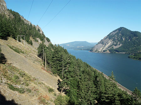
The most interesting section of BPA trail that is not currently a signed route is the trail over Shellrock Mountain. While this is only for the most experienced hikers today, it’s a great adventure that includes magnificent views of the Gorge that few enjoy. Hopefully, this route will someday be connected to Gorge Trail 400 — as it should have been as part of this project.
In the meantime, consider exploring the corridor by visiting the connecting trails at Mitchell Point, Wygant Peak, Starvation Creek and where the PCT crosses the corridor on the route to Dry Creek Falls.
Most of the land in the corridor is in public ownership and managed by Oregon Parks and Recreation or the U.S. Forest Service, so you are free to walk the trails and service roads here. This is the best way to see first-hand how your public lands are being managed, even if the BPA has let us down in their efforts to involve the public in this project.
