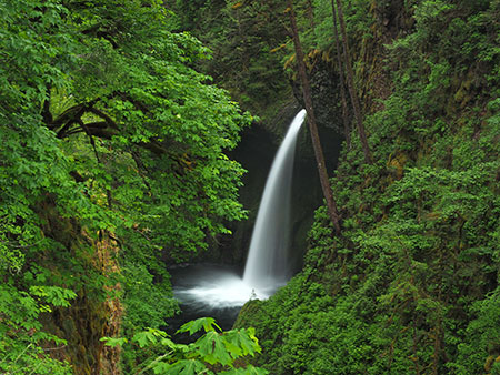
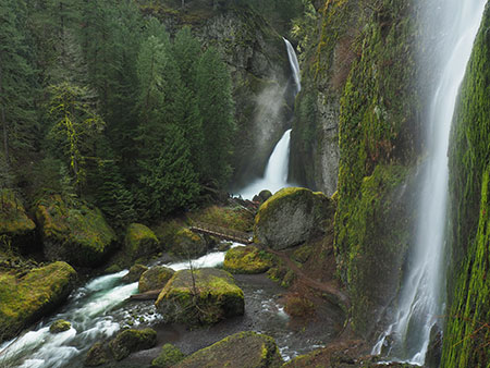
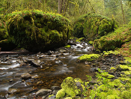
Metlako Falls from the viewpoint that is no more…
The buzz in hiking circles over the past few weeks has been the massive cliff collapse at iconic Metlako Falls on Eagle Creek. While the falls, itself (and the gorgeous surrounding amphitheater that also includes 100-foot Sorenson Creek Falls) was not affected by the collapse, the cliff-edge viewpoint that countless hikers have visited over the decades is now only a memory.
It started with a crack in the ground…
In late November, local hiker Karl Peterson posted a report with images of a deep, ominous crack in the forest floor above the Metlako viewpoint at his Portland Hikers Facebook group. Karl correctly predicted that some sort of collapse or landslide was imminent, though few expected something of this scale.
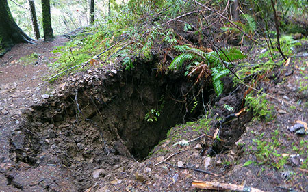
The foreboding crack that formed in November (photo: Karl E. Peterson)
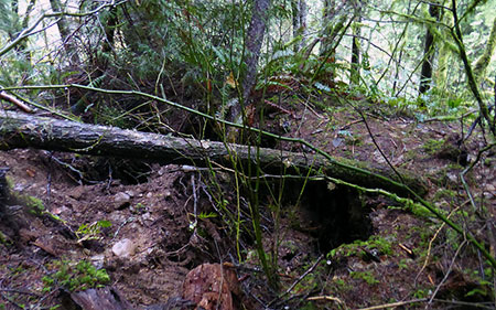
Another view of the crack in late November (photo: Karl E. Peterson)
While major landslides and cliff collapses are regular events that continue to shape the Gorge as we know it, Karl’s discovery of the crack appears to be the first time an imminent collapse was observed and predicted in this way. Karl also reported trees leaning toward the 200-foot abyss, a more common predictor of landslides.
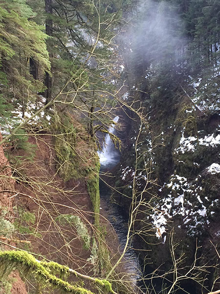
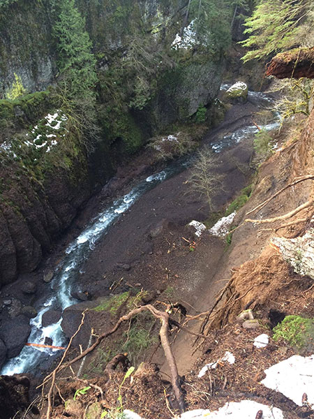
Roughly a month after Karl’s discovery, a massive 300-400 foot long section of the east wall of the gorge below Metlako Falls dropped 200 feet into Eagle Creek. The collapse occurred sometime between December 17 (currently, the date of the last known photo taken from the overlook) and 26 (when the first known photos of the collapse were taken), but was apparently not witnessed by anyone – and thankfully, nobody was injured or killed by the event.
Metlako Falls from above the old viewpoint – for reference, the arching maple in front of the falls is the same as the one to the left of the falls in the opening photo in this article (photo: Nathan Zaremskiy)
Given the year-round crowds on the Eagle Creek trail, the lack of eyewitnesses suggests the collapse occurred at night, or perhaps on a day when travel was especially light due to winter weather in the Gorge that week.
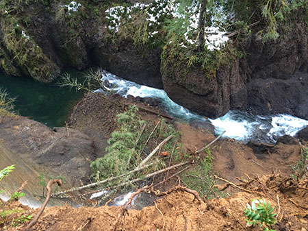
The sheer volume of debris in the creek was enough to temporarily block the stream, and a deep pool is still backed up behind the jumble of automobile-sized boulders and smaller material, as shown in these amazing photos by Karl, and fellow photographers Don Nelsen and Nathan Zaremskiy:
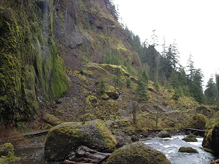
A view of the sheer escarpment where the cliff split off and the large pool created by the debris in the creek below (photo: Don Nelsen)
A wider view of the new escarpment and debris at the base of the cliff, with Metlako Falls in the distance (photo: Don Nelsen)
This dizzying view looks straight down from the brink at Eagle Creek, pushed against the west cliff wall by the debris pile (photo: Nathan Zaremskiy)
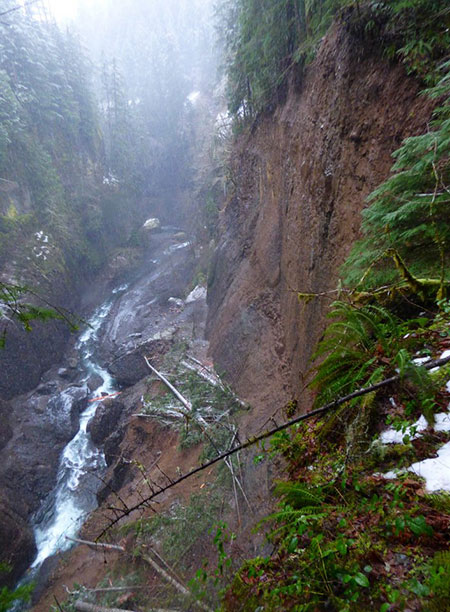
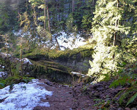
The escarpment left by the collapse is sheer and still unstable, with trees and remnants of forest floor still dangling on the edge, as shown in these photos taken after the event:
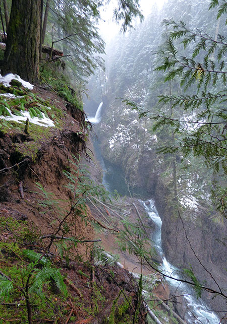
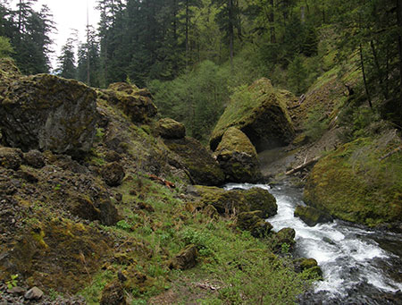
This view looks downstream toward the old viewpoint location and the full extent of the collapse (photo: Don Nelsen)
Another view looking downstream from just below the old viewpoint, and toward the bend in Eagle Creek at the north end of the Metlako gorge (photo: Nathan Zaremskiy)
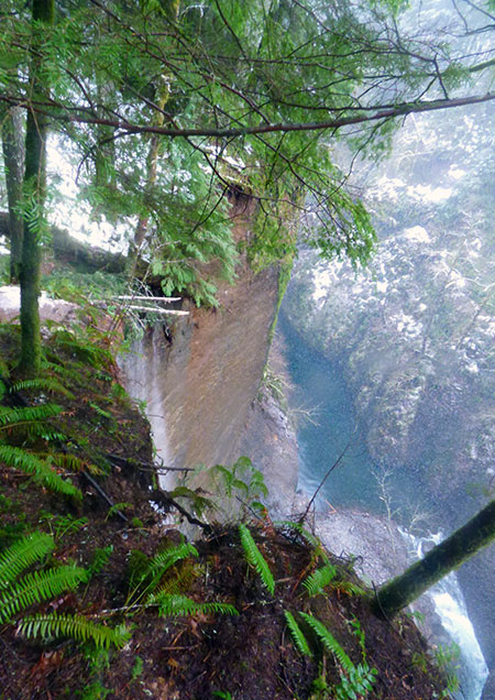
A portion of the short spur trail to the old Metlako viewpoint still exists… until it ends at this scary abyss:
The old spur trail ends abruptly at the edge of the new escarpment… yikes! (photo: Karl E. Peterson)
Nathan Zaremskiy also created this stunning YouTube video of the scene after the collapse:
Just the Gorge doing its thing?
It turns out that the collapse at Metlako is as routine to the evolution of the Gorge landscape as rain, waterfalls and basalt cliffs, albeit measured over decades and centuries.
Several collapses have occurred over the past few decades, and are fairly well documented. One of the most dramatic occurred on September 6, 1995 when a massive, bus-sized slab of basalt dislodged from the vertical cliff behind Multnomah Falls.
Even in the era before ubiquitous cell phone cameras, one visitor managed to capture this startling image of the of the rockfall exploding into the splash pool at the base of the falls, completely inundating Benson Bridge (you can see it if you look closely) with water and debris:
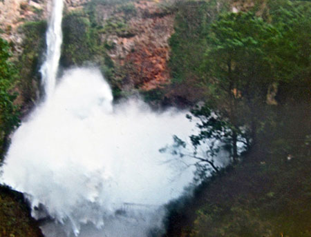
The astonishing photo capturing the rockfall at Multnomah Falls in 1995 (USFS)
One person on the bridge was slightly injured with flying rock debris, but amazingly, no deaths or other injuries were reported.
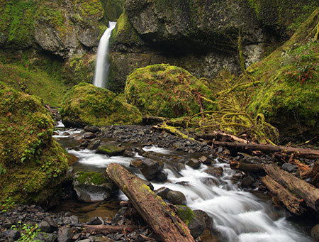
In 1973, a massive cliff collapse along Tanner Creek below Wahclella Falls was so large that it temporarily stopped the flow of the creek, cutting off the water supply downstream to the Bonneville Hatchery. The landslide created a lake on Tanner Creek that persisted until the late 1970s, long enough to show up on USGS topo maps:
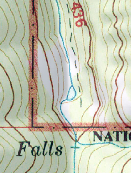
The lake formed by the Tanner Creek cliff collapse in 1973 lasted just long enough to appear on USGS maps.
Today, this slide is still recovering, and remains one of the most visible and fascinating places to witness the power of nature at work. The trail to Wahclella Falls was rebuilt as a loop in the late 1980s, with the western leg traveling over the toe of the landslide, among the giant boulders left in its wake.
The view downstream toward the Tanner Creek landslide debris field (and west leg of the loop trail).
The giant boulders in this downstream view are at the toe of the Tanner Creek landslide, and initially dammed the creek here to form a small lake.
The east leg of the loop trail climbs high above the creek, providing a birds-eye view of the scene, and true sense of scale of the event:
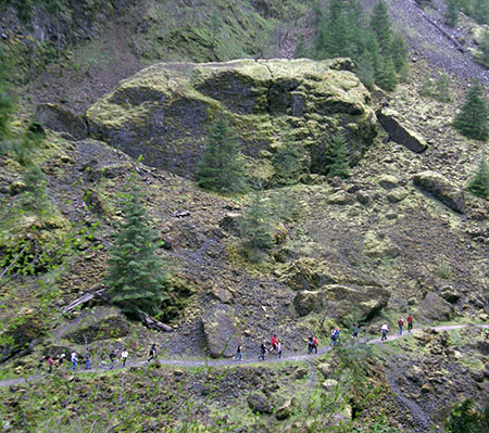
This view across Tanner Creek canyon shows hikers along the trail section that crosses the debris field below one of several house-sized boulders scattered in the rubble.
Though we don’t know exactly how or when the jumble of house-sized boulders scattered below Wahclella Falls arrived there, they each bring their own story of a catastrophic wall collapse that is part of a continuum as the Gorge streams continue to etch their canyons into the underlying basalt.
Each of the giant boulders scattered below Wahcella Falls has its own story of a major cliff collapse.
A less-traveled canyon just over the ridge from Tanner Creek also experienced a major wall collapse sometime in the recent past. Moffett Creek cascades over its own spectacular series of wateralls, but no trails lead into this remote canyon. Instead, explorers follow the stream, where massive boulders are scattered along the way. In one section, they form a beautiful moss-covered garden, with glacier lilies blooming on top of the boulders in early spring:
Giant boulders scattered along Moffett Creek
At Moffett Falls, the first waterfall on the stream, a major rockfall dropped the garage-sized boulders in front of the cascade sometime in the late 1980s or 1990s:
The huge boulders below Moffett Creek Falls are relatively new arrivals to the scene.
This event also obliterated an alder forest that extended along the canyon floor below the falls, perhaps as the debris dam abruptly collapsed under the pressure of Moffett Creek backing up behind it.
What’s next for Metlako?
Eagle Creek is perhaps the most visited trail in the Gorge, with hikers crowding the area since the trail first opened nearly a century ago, but the history of the old spur trail and viewpoint at Metlako Falls is unclear.
Because of the early popularity of the trail, it’s odd that old photos of the falls don’t seem to exist, compared to the many photos and postcards from the 1920s and 1930s of other waterfalls and overlooks along the trail. This suggests that the viewpoint at Metlako Falls was developed later.
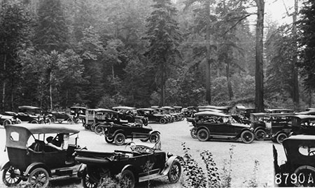
Overflowing parking at Eagle Creek is not new..!
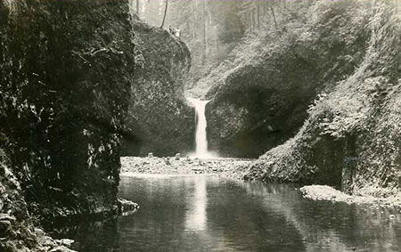
Early photos of Punchbowl Falls and other sights along the Eagle Creek trail are common… so why not Metlako Falls?
The galvanized steel posts and cable railings at the old viewpoint were newer than the original hand cables that famously line several of the exposed cliff sections along the trail, so it seems likely they were added later – perhaps with the spur trail, itself.
One possibility could be that Civilian Conservation Corps (CCC) workers built the spur and overlook in the 1930s, when other trails were being added throughout the Gorge. The railing design also matches that of other trails built in the 1930s and 1940s in the Gorge.
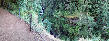
Panoramic view of the old viewpoint at Metlako, now lost to the ages.
(click here for a large view of the old Metlako viewpoint)
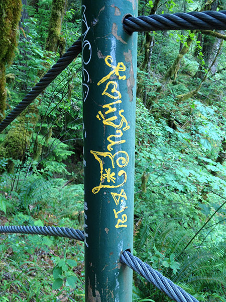
The steel railings at Metlako seemed newer than the original trail (and the tagging still newer)
For now, the Forest Service has roped off the short spur trail that once led to Metlako Falls, warning hikers to stay away from the still-unstable area. But the agency is also reported to be exploring the possibility of a new viewpoint of the falls.
Such a viewpoint seems unlikely, based on early reports by hikers. The collapse took away an enormous amount of cliff, yet left a section near the falls that now blocks the view from the new cliff wall downstream. If so, Metlako may live on mostly as a memory for most, though photographers with drones will no doubt attempt to recreate the iconic view that once was!
Like losing an old friend…
…and on a personal note, the news of the Metlako viewpoint collapse came hard, as I had been doing periodic maintenance of the overlook several years ago as a volunteer for Trailkeepers of Oregon to preserve the view.
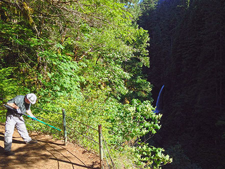
Improving the view at Metlako Falls
The work consisted of carrying an 18-foot pole pruner to the site and trimming the thicket of bigleaf maple shoots, ocean spray and snowberry that blocked the view and encouraged visitors to climb over the railing (!) for a look at the falls.
It was fun and rewarding work, albeit unnerving to watch the trimmings float over the vertical brink of the 200-foot cliff and into the creek, below. I worked with the sure safety of a the cable fence, but always thought about the rugged early trail builders who worked along these cliffs to create the original Eagle Creek trail – brave souls!
So, to close out this article, I’ll post one of the last photos I took from the old viewpoint in June 2016…
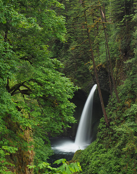
Metlako Falls as it will live on in photographs and memories.
…and along with so many other hikers and waterfall lovers, say goodbye to this wonderful spot…

Excellent coverage on Metlako Tom!
________________________________
LikeLike
Thank you, Brent!
LikeLike
You must have removed too much vegetation with your viewpoint clearing! Must have destabilized the slope.
Just kidding of course.
LikeLike
Thank you for this extensive update…
LikeLike
Great article
If you want to know the exact date of the land side collapse, stop and talk to the eagle creek Hatchery. It blocked the river for an hour or two and they scrambled to protect the fish at the hatchery
LikeLike
Here’s to the “rugged early trail builders” and the more recent trail protectors! Thanks, Tom (and your trail protector partners).
LikeLike