
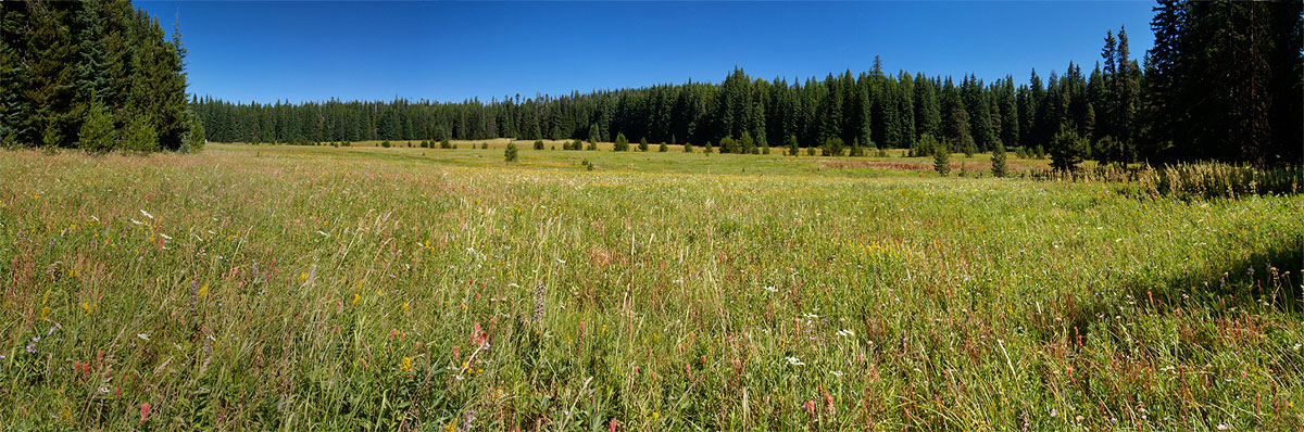
Brooks Meadow from the west
Brooks Meadow is one in a string of sunny meadows located on the gentle northern slopes of Lookout Mountain, just east of Mount Hood. At 35 acres, Brooks Meadow is among the largest, and has a long human history thanks to the water and forage it offers. It was likely visited for centuries by Native Americans, and in the late 1800s, was grazed with sheep following white settlement of the region.
(Click here for larger view of Brooks Meadow)
Early settlement trails in the area connected the dots between meadows and water sources, with several converging at the Brooks Meadow by the early 1900s. A guard station was constructed at the upper end at that time, near the junction of three trails at the north edge of the meadow. Later, the trails became primitive forest roads.

Brooks Meadow was surrounded by clearcuts by the 1980s
By the 1950s, sheep and cattle grazing in the Lookout Mountain area was on the decline, giving way to a boom in commercial logging. Timber harvests focused on the big ponderosa and larch stands unique to the east slopes, and mills in the area thrived. The timber boom hit its peak in the 1980s, when miles of logging roads and hundreds of clearcuts transformed the slopes of Lookout Mountain.
When the sawdust settled in the early 1990s, Brooks Meadow was somehow spared, a lush island in a forest that had been almost completely logged in all directions. By sheer luck, when the commercial logging boom swept the area, the old primitive road and trail system was mostly bypassed or destroyed by the modern, paved roads that carries logs to the mills.

A thin veil of trees were spared along the periphery of Brooks Meadow
At Brooks Meadow, a new paved route was built around the north side of the meadow (shown above), bypassing the historic dirt track through the center of the meadow. The Dufur Mill Road was also paved, and routed just south of the meadow, proper.
Thankfully, the relocated roads kept the steady stream of log trucks out of the meadow, and allowed the fragile ecosystem to survive the logging era relatively intact. In fact, the curtain of trees that was spared along the margins largely hides the meadow from today’s travelers, allowing Brooks Meadow to remain surprisingly unknown.

Old topographic maps still show the abandoned dirt roads and former Guard Station at Brooks Meadow
When the paved roads were built, the primitive roads through the meadow were simply abandoned, and never properly decommissioned. In the intervening years, these abandoned roads have begun to reforest, thanks to the drainage that keeps the old roadbed drier than the surrounding meadow, and survivable for trees.
A closer view (below) of Brooks Meadow shows the abandoned road, and the dotted line of young trees that have begun to grow along the old roadbed. The location of the former guard station that once stood here is also shown.

The old road through Brooks Meadow is revealed by the young trees growing along it
Many of the meadows in the Mount Hood area are shrinking, thanks in part to a century of fire suppression and climate changes that allow for gradually encroaching forests. For Brooks Meadow, the threat comes from within, as well, with the strip of forest along the old road threatening to divide-and-conquer the meadow with reforestation.
This doesn’t have to happen, of course. The purpose of this article is to prod the U.S. Forest Service to consider a brushing project to remove the young trees along the old roadbed, and perhaps consider changes to the road’s drainage features that would help the old roadbed blend into the meadow, once again.
The brushing project is straightforward: there are about 60 young trees scattered along the old road, and they are small enough to removed by volunteers armed with bow saws and loppers. The drainage project would likely require more work, but could still be done by volunteers, assuming it is akin to trail maintenance work using hand tools.
Here is my offer to the U.S. Forest Service: I will assemble work crews of 10-12 volunteers for the brushing and drainage work needed to save Brooks Meadow. I believe the brushing could be done in a single day, and the drainage work in 2-3 volunteer days. Let’s get it done – we just need the green light from you!
Visiting Brooks Meadow
The best time to visit Brooks Meadow is in June and early July, when the wildflowers are at their best. In many spots, the flowers are waist-deep, and you will be surrounded by the sound of buzzing bees, singing birds and perhaps even spot elk or deer. There is no formal trail, but the going is easy if you follow the tree line along the edges of the meadow.

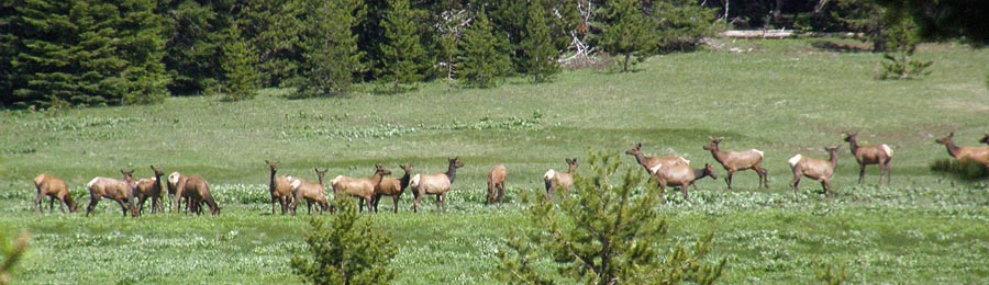
Elk grazing in the upper section of Brooks Meadow in 2009
(Click here for a larger view)
The route begins at the pullout “trailhead” at the west end of the meadow (see driving instructions, below). The best way to tour the meadow is clockwise from the pullout, following just inside the treeline. This will keep your feet fairly dry, and protect the most pristine inner portions of the meadow from human traffic.
In the clockwise loop around the meadow, you will be rewarded with mountain views from the upper end, and huge drifts of wildflowers in early summer. Autumn is also a beautiful time to visit the meadow, though you should wear hunters colors whenever hiking on the east side in fall. In morning and evening, there are often elk and deer browsing in the meadow. Be forewarned not to approach elk herds — simply enjoy them from a distance.

One uncommon plant to look for in the meadow is Agoseris elata, or tall agoseris. This plant is in the sunflower family, and looks a bit like a dandelion blossom on steroids. Agoseris elata grows in just two places in the entire Mount Hood National Forest — Brooks Meadow and nearby Bottle Prairie.
How to Get There
Brooks Meadow is located just off Forest Road 44, east of Mount Hood. Follow Oregon 35 from either Hood River or US 26 to the Forest Road 44 junction. Turn east, and follow Road 44 uphilll for several miles to the obvious intersection with Forest Road 17, where Forest Road 44 abruptly turns right. Continue straight at this intersection, onto Road 17, and immediately watch for a pullout just 100 yards from the intersection.
(There are no restrooms or water sources at this informal trailhead. The nearest facilities are at the Sherwood campground, located along Highway 35, north of the Road 44 junction)
Postscript
After publishing this article, I noticed that the Forest Service and City of The Dalles have been busy posting the boundaries of The Dalles Water Watershed, again, including the informal trailhead at Brooks Meadow.

At least the shooters appreciate the new targets posted at Brooks Meadow
It’s a bit hard to take the closure seriously (most don’t, actually), given how the agencies have carved up this once pristine area with miles of logging roads and hundreds of clearcuts. More absurd is the fact that the “protected” stream flowing from the meadow is soon piped under paved Brooks Meadow Road in an open culvert — apparently, an area where protection isn’t required. Beer cans tossed in the culvert from passing pickup trucks complete this ironic picture.
So, use your judgment in visiting Brooks Meadow. While it’s hard to believe that hikers visiting the meadow to appreciate its beauty would actually be prosecuted (and spend the advertised six months in jail and a $500 fine, no less!) the posted closure is for real, unfortunately.

Tom –
There is Boy Scout Camp nearby (Camp Baldwin) that could probably generate a bunch of volunteers.
I could help rally my son’s troop to help with this effort.
LikeLike
Based on this posting, I decided to visit a couple weeks ago. One thing you do not mention that is very important- public access to this site is prohibited. The site is located within the City Dalles municipal watershed and it is explicity signed that access is prohibited and subject to a $500 fine.
A disappointment because it sure did look like a nice meadow! Kudos on a very nice writeup.
LikeLike
Thanks, Tom – that’s a great idea (and I have a bit of history with Camp Baldwin, myself — staff alumnus from back in the day). I’m hoping to connect with a Mount Hood NF biologist that I talked to awhile back, and see if this can happen.
Steve, thanks for posting that caveat. I noticed the same thing last weekend, when I saw that new boundary signs had been posted up and down Surveyors Ridge Road. I’ve updated the article, accordingly, though with a bit of grumbling, as I’m not a believer in the need to lock visitors out of watersheds.
LikeLike
Pingback: 2012 Mount Hood National Park Calendar « WyEast Blog