![]()
Since tourists first began exploring Samuel Lancaster’s graceful new Columbia River Highway in 1915, Latourell Falls has been a favorite stop. In the early days, a pair of roadhouses (the Falls Chalet and the Falls Villa) flanked the highway at the east end of the dramatic highway bridge spanning the creek, and offered lunch with a view of the falls.
Today, the falls are the main focus of Guy Talbot State Park, with thousands of visitors each year exploring the series of loop trails that circle the lower falls and follow Latourell Creek to the upper falls.
The Falls Chalet in 1915
The scenes along Latourell Creek are beautiful and iconic, and most visitors simply accept that this place will be protected forever for the public. Yet, experienced hikers notice something different about this western-most of the waterfall trails in the Columbia Gorge: it’s not pristine, at least not in the way that other streams in the Gorge are. Despite the beautiful setting, big trees, wildflowers and waterfalls, something about this stream seems degraded.
![]()
When crossing the rustic footbridge at the thundering base of Latourell Falls, there is often a distinct odor of algae in the air. A closer look at the stream reveals not only algae on the rocks, but also crusty mineral deposits that also suggest degraded water quality in this beautiful stream, and would help explain the algae blooms.
This close-up view (below) is a detailed look at the lower right corner of the previous image of Latourell Falls. The close-up view reveals white mineral deposits and yellow-grown algae stains on several boulders and cobbles. This view also shows fine silt deposits (brown areas in the lower right) that suggest some sort of major disturbance in the watershed.
![]()
Why is this? What’s behind the water quality problems on this otherwise untouched stream?
Going to the Source
Upstream from the waterfalls and throngs of visitors along the lower canyon section of Latourell Creek, an explanation for the degraded water quality is revealed. Though few visitors to the lower reaches of the stream would imagine it, the headwaters of Latourell Creek are privately owned, with a number of homes and a lot of logging along the stream.
Amazingly, more than three quarters of the Latourell Creek watershed lies outside the protection of public parks and the Columbia River Gorge National Scenic Area (CRGNSA).
While the private homes are partly responsible for the nutrients that feed algae and leave mineral deposits in Latourell Creek (from lawn chemicals, septic tanks and other sources), the aggressive logging of private lands in the upper watershed is the greatest risk to stream quality.
![]()
The environmental impact of logging in the headwaters is painfully obvious, with canyon slopes recklessly harvested in clearcuts. This is a discredited, outmoded form of timber management that shouldn’t be practiced anywhere, much less a stream of this caliber that flows into a National Scenic Area.
The clearcut photos shown here were taken in the summer of 2010, with most of these harvests just a couple of years old. In this view (below), an older clear cut can also be seen on the hillside across the canyon, and is just beginning to recover with a light green layer of growth. Most of these forests have been cut several times, with ever-shortened growth cycles between harvests, thanks to a growing market value for marginal timber.
![]()
In this view (below) raw skid roads in the lower right drain directly into Latourell Creek, which flows along the tree line, at the edge of the clearcut. Erosion from bare slopes and logging roads is responsible for the most fine sediments (mud) seen below, in the protected sections of Latourell Creek. These sediments not only spoil the stream bottom, they also introduce minerals at a rate which promotes the growth of algae, which in turn, can also harm stream health.
![]()
Sadly, Oregon law continues to allow timber harvesting using the clearcut method, and the few environmental protections that do exist for stream protection on private timberlands are little compensation for the effects of clear cutting.
The tragic reality is that in Oregon, the timber lobby is still king. Twenty years of non-stop public relations advertising (kicked off during the early 90s Spotted Owl crisis) by Big Timber have been surprisingly effective in keeping the public largely misinformed on what is really happening in private forests.
In this view (below) of upper Latourell Creek, the private property owner has left the minimal amount of riparian “buffer” required by Oregon law. The trees in this photo are less than ten feet from the edge of Latourell Creek, and most of what you see is actually growing on the opposite bank from the clearcut. Clearly, this practice threatens severe erosion and sediments from the logged area entering the stream in a region where rainfall amounts can reach 100 inches annually.
![]()
Clearcuts threaten more than steams and water quality, however. In the 1990s, the Oregon timber lobby was forced to accept limits on clearcutting above roads and dwellings because of a number of catastrophic slides that had been triggered around the state by the practice.
Yet, few limits on logging below developed roads exist, and in the case of the upper Latourell canyon clearcuts, the impact of logging on the slopes below the local roadways is real. In the following view, large trees have not only been recklessly cut from the slope below the road, but the remaining smaller trees and shrubs have been sprayed with herbicide — a routine treatment after clearcutting — and thus killing what was left of root systems that help hold the slope together. As the image indicates, there are already active slides along this slope, triggering road repair costs that will fall upon the public to fix, not the private land owner.
![]()
This photo (below) shows the slide repair in more detail — a 200-foot section of road that has already been filled and patched repeatedly, and now will likely continue to fail thanks to a slope that has been further destabilized by aggressive logging.
![]()
What’s the Solution?
For much of Oregon, the fate of clearcutting is an open question, with the timber lobby thus far successful in its efforts to prevent the practice from being outlawed. That’s a shame, and a sad commentary on our state politics. But in the case of Latourell Creek, there’s another option.
When the authors of the Columbia River National Scenic Area (CRNSA) were drawing up maps, they focused on scenery and what could be seen from points along the Columbia River. As a result, the scenic act ignored a crucial lesson learned from the newer national parks of the 1960s — most notoriously, Redwoods National Park — that when acquiring park lands, complete ecosystems and watersheds should define the boundaries.
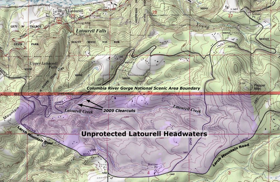
A look at the CRNSA boundary in the Latourell Creek headwaters shows the problem: the upper watershed falls outside the scenic area, and thus is excluded as a place for meaningful regulation or public land acquisition.
![]()
It doesn’t have to be this way, however. These lands should be added to the CRNSA, and managed holistically, with the health of the spectacular lower canyon in mind.
After all, Latourell Creek is the only major stream on the Oregon side of the Gorge to straddle the boundary, and thus a good case can be made for amending the CRNSA boundary to incorporate the complete watershed. This would allow for better regulation of private lands in the headwaters, at a minimum, and also allow for CRNSA land acquisition funds to be used here.
Upper Latourell Falls
Another argument in favor of expanding the CRNSA boundary is the convenience of Larch Mountain Road in defining the Latourell Creek watershed. This popular recreation route is already viewed as “part” of the scenic area, albeit outside the boundary in this section. Therefore, an expanded boundary would allow the full Larch Mountain Road corridor to be managed as an extension of the scenic area. This extent is reflected on the map, above.
What Would it Take?
Amending the CRNSA requires an act of Congress, and though it sounds daunting, minor changes to federal boundaries of this sort are common as “riders” on larger federal lands bills.
While better regulation of private lands in the upper Latourell watershed would surely come from an expanded CRNSA, the chief benefit would be the ability to acquire lands for restoration. Already, the Forest Service has acquired hundreds of acres of private elsewhere in the Gorge, and the upper reaches of Latourell Creek would be best protected by fully restoring the watershed.
Upper Latourell Falls
Yet another option could be for advocacy organizations — like the Friends of the Columbia Gorge or Trust for Public Lands — to acquire the upper watershed lands. However, these groups generally operate inside the existing CRNSA boundary, and focus limited funds on still-pristine lands or those with exceptional scenic value.
In the end, it seems that our best bet is for the Oregon Congressional delegation to consider a “housekeeping” update to the CRNSA, including boundary refinements. Perhaps a 20-year review of the CRNSA is in order in 2016?

Very interesting Tom, I had no idea. That’s one of my favorite hikes with the boys. Something more to think about now.
LikeLike