The Noblest of Firs

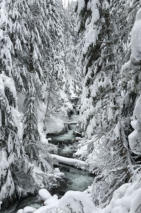
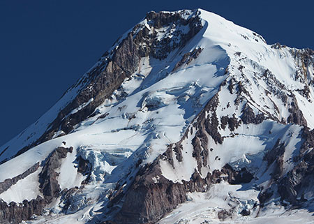
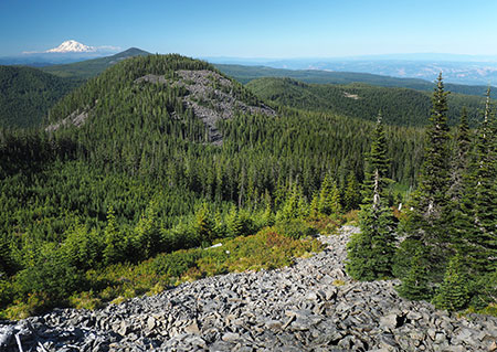
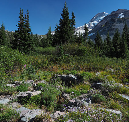
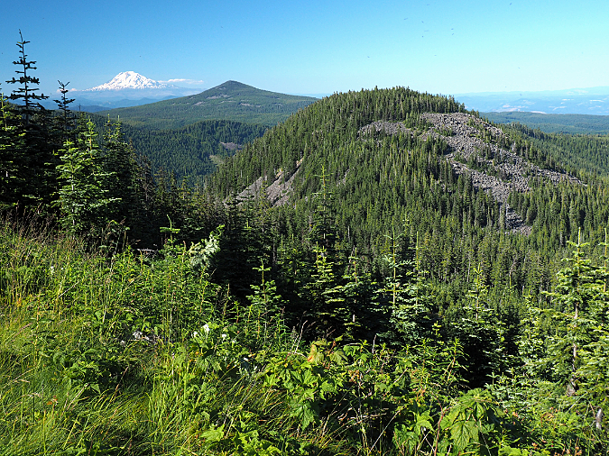
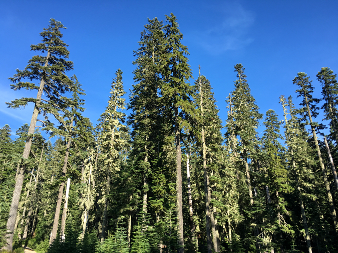
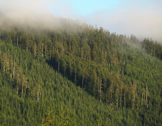
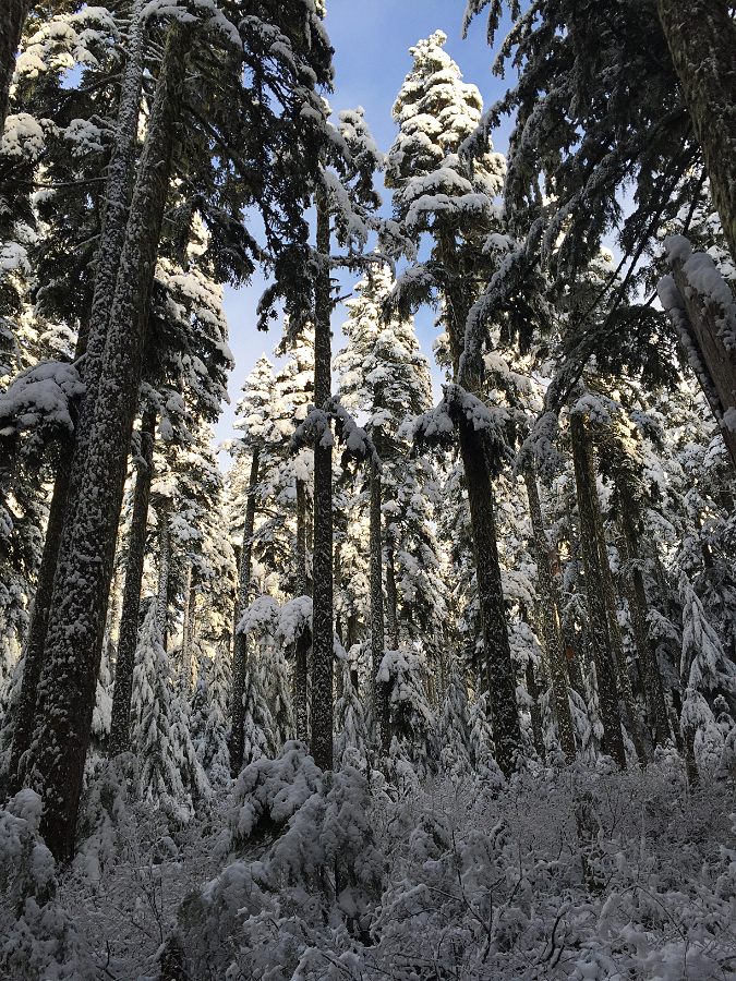
Forests of Noble fir forests spread out to the horizon along the crest of Waucoma Ridge, just north of Mount Hood (Mount Adams in the distance)

We’re coming into another holiday season when millions of Americans will set up a Christmas tree cut in Oregon. There’s a good chance it will be a Noble fir, long prized as the most beautiful and durable of Christmas trees, representing about a third of the cut tree industry here. 

There was a time when Noble fir grown as holiday trees were left in their natural state, which features elegant tiers of symmetrical branches and soft, deep green, upwardly curving needles. In recent years, Nobles grown for mass-market consumption have increasingly been sheared to produce a densely branched, unnatural thicket (acknowledging my bias, here!) in the same way that Douglas fir have long been cultivated in the Christmas tree trade. Still, the un-sheared Nobles remain the gold standard, and they sell for gold-standard prices at tree lots, too.

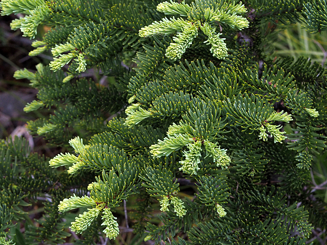
New grown emerging on Noble fir boughs
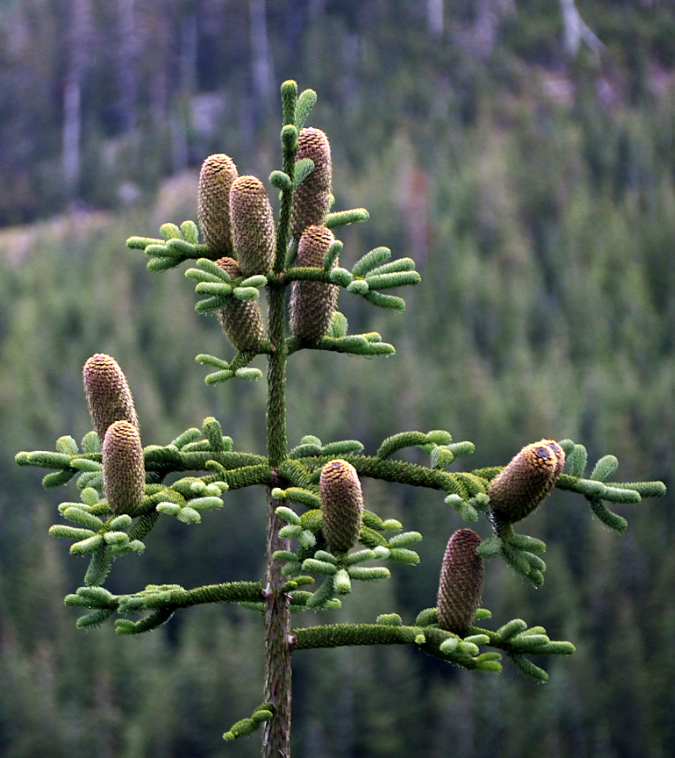
Noble fir cones

In Oregon, families also have the option of cutting their own Christmas trees at U-cut tree farms, a popular benefit of living in a region that produces millions of holiday trees for the nation. It’s also possible to cut your own tree on National Forest land, a tradition that dates back a century or more. Though more regulated today by the U.S. Forest Service, families looking for a more adventurous option than local tree lot can head up to designated areas on the mountain (typically powerline corridors or recovering clear cuts) and bring home their own cut tree.

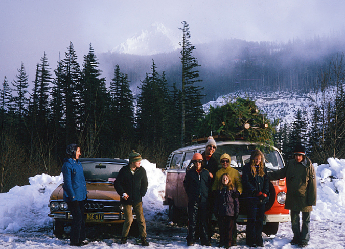
The author at age 11 (second from left) with family and friends on a 1973 trip to Lolo Pass to cut Christmas trees. Noble fir were always the goal, but in those days of heavier mountain snows, simply reaching the Noble fir zone in December was an adventure!

Christmas trees are pretty much the extent of public knowledge of the noblest of our true firs. As the common name might suggest, noble fir is the largest of all true firs. Their name was given in the fall of 1825 by botanist David Douglas when he ventured into the high country above the Columbia River River Gorge, in the vicinity of today’s Cascade Locks. Though he wasn’t specific about the peak he climbed on the north side of the river, it is believed to be today’s Table Mountain. A few days later, he climbed to a high point on the Oregon side, most likely today’s Benson Plateau.

On this pair of climbs, he came upon magnificent, old-growth stands of Noble fir, and gave them their well-deserved name. While they are undeniably beautiful as young trees, old-growth Noble fir are a sight to behold. Like many of our Pacific Northwest conifers, these trees grow to be giants, with the largest on record reaching nearly 300 feet in height and nearly 10 feet in diameter.  

Old-growth Noble fir forests near Mount Hood’s Bennett Pass

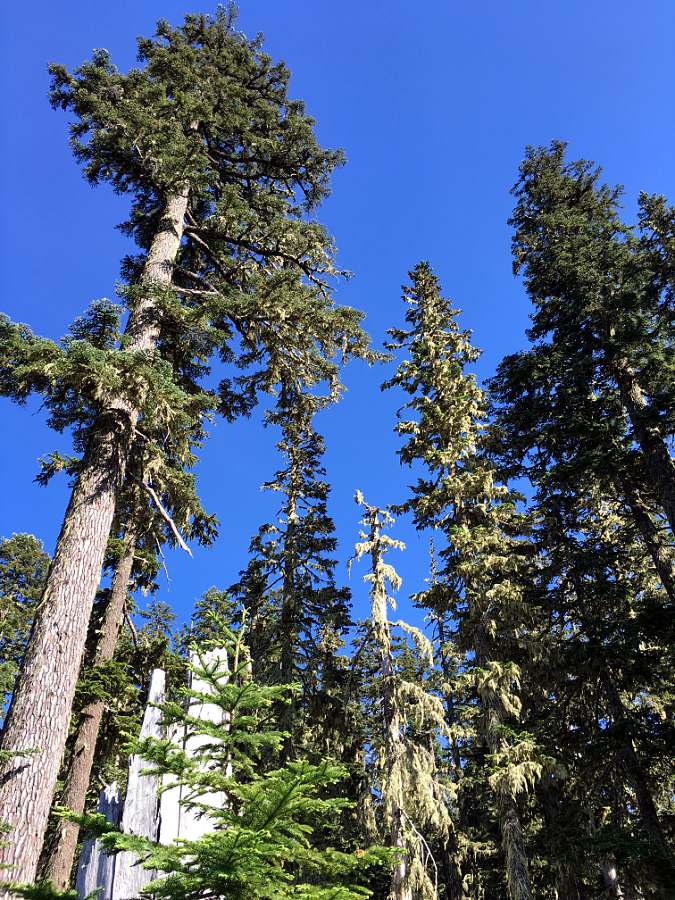
An ancient Noble fir giant towers above the surrounding forest canopy near Bennett Pass

Noble fir are also unique to the Pacific Northwest, with a range that extends from just above of Snoqualmie Pass in Washington south to the Siskiyou Mountains in Southern Oregon and the Trinity Alps region along the northern edge of California. In their southern extent, they are known to hybridize with California’s Shasta fir, a variety of the Red fir that grows in the Sierras and extends into the southern fringe of the Noble fir range.

Despite their willingness to grow in planted rows as farmed Christmas tree seedlings in the hot, dry summers of the Willamette Valley floor, Noble fir are a subalpine species. They typically grow at elevations of 3,500 feet to 5,500 feet, where they are long-lived and acclimated to the harsh winters of our mountains. Not surprisingly, they grow more slowly under these conditions, but they are tremendously adaptable, and often grow on very steep mountain slopes and exposed, rocky ridgetops.

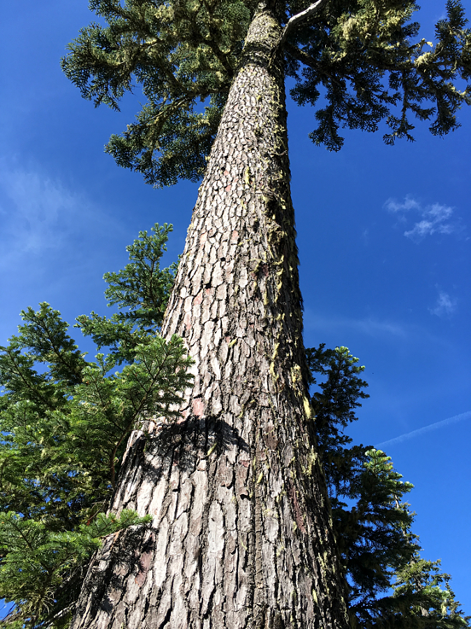
Centuries-old Noble fir giant near Bennett Pass

Noble fir is a sun-loving pioneer species in our forests, quickly colonizing in burn areas to form pure, long-lived stands. Hike through one of the towering old-growth stands found in the high country of the Columbia Gorge or on the peaks surrounding Mount Hood, and you’re likely walking through an old burn, with the age of the trees as a good indicator of when fire last roared through, long ago. That’s because they are not only post-fire colonizers, but also highly susceptible to fire as mature trees, as they lack the protective bark of fire-adapted conifers like Ponderosa pine and Western larch.

This cycle of burn-and-rebirth in our Noble fir forests is on full display today on the north slopes of Mount Hood, where the 2011 Dollar Lake Fire burned through sprawling stands of subalpine Noble fir. These forests were almost entirely killed where the fires swept through, yet today, the forest recovery is already well underway, with young Noble fir seedlings leading the way among other post-fire pioneer species.

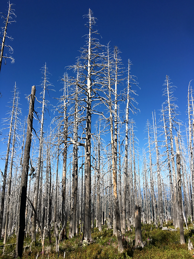
Ghost forest of Noble fir skeletons where the Dollar Lake Fire swept through a decade ago

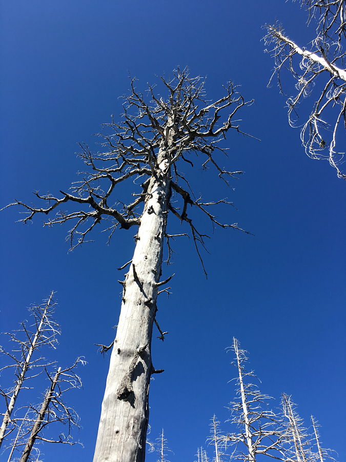
Ancient Noble fir killed by the Dollar Lake Fire will provide wildlife habitat for many decades to come as a new forest grows here

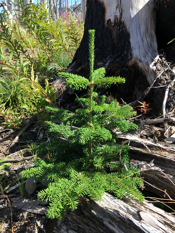
Noble fir seedling emerging from the charred ashes of the Dollar Lake Fire

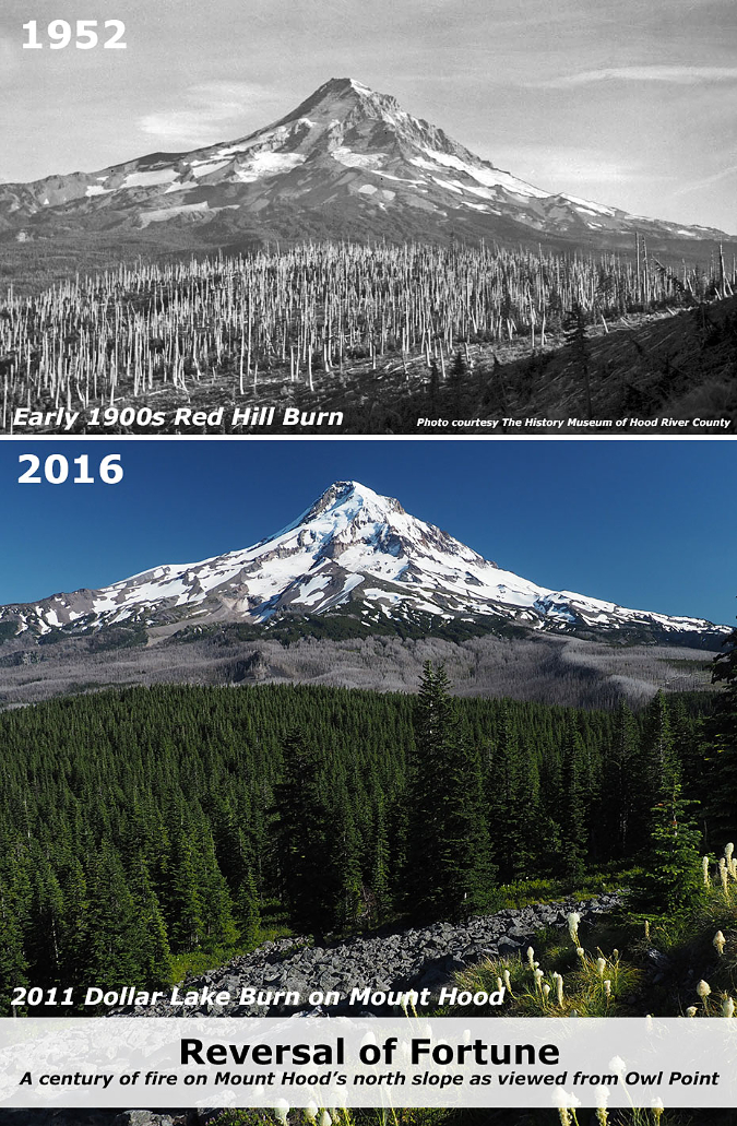
Meanwhile, across the Clear Branch canyon on the north of the mountain, the forests along the crest of Blue Ridge and at Owl Point (along today’s Old Vista Ridge Trail) are made up almost entirely of Noble fir that had colonized an earlier burn there, one that occurred sometime in the early 1900s. This pair of photos (below) from Owl Point shows how the foreground was burned and just beginning to recover in 1952, while 70 years later the scene is reversed: the forests along Blue Ridge and Owl Point have largely recovered, while the north slope of the mountain is just beginning its recovery from the 2011 Dollar lake Fire.

When our Noble fir forests are spared of fire and logging, individual trees can easily live up to 400 years.  The oldest known Noble fir have reached 600 to 700 years, though trees of this age are exceedingly rare after more than a century of commercial logging in the Pacific Northwest. 

In the early days of extensive logging, in the late 1800s and early 1900s, true firs were considered a lesser wood, so the timber industry marketed the massive, old-growth Noble firs as “Larch”. This explains two Larch Mountains in the Columbia River Gorge, one on each side of the river, and each the site of extensive turn-of-the-century logging in the early 1900s. The better-known Larch Mountain is on the Oregon side, and its broad, high elevation slopes provided a perfect habitat for Noble fir.

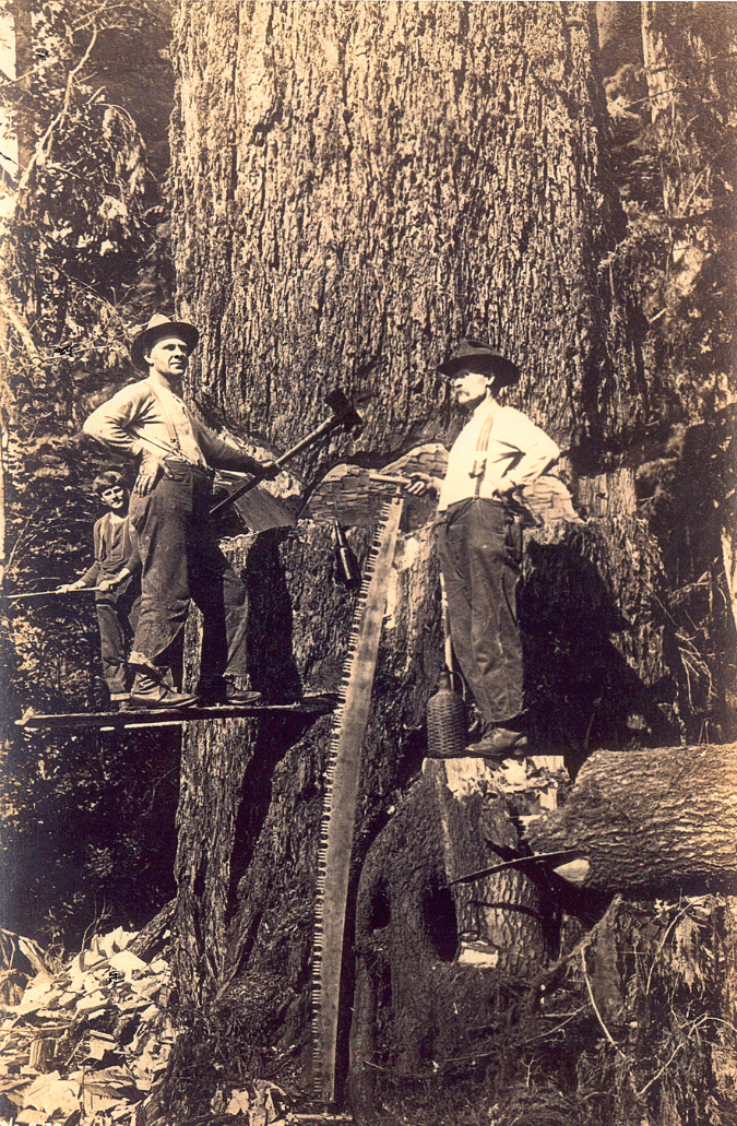
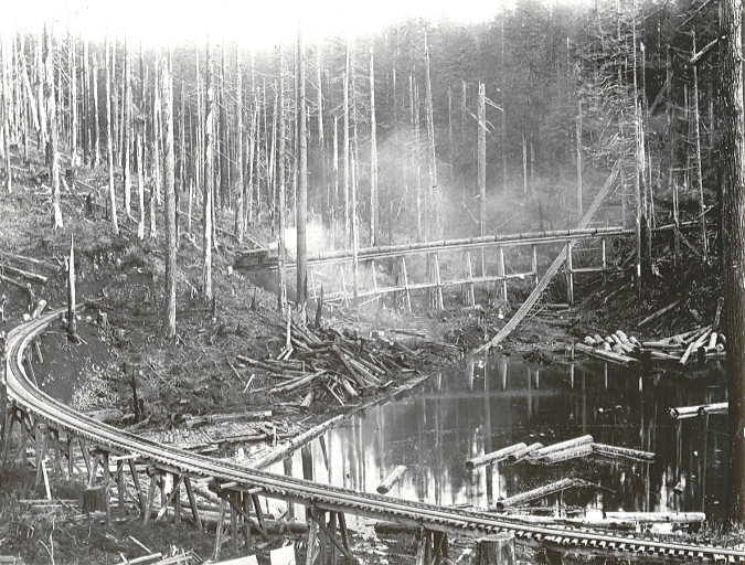
Loggers felling a massive Noble fir on Larch Mountain in 1905

By the early 1900s, the Bridal Veil Mill on the Columbia River had established an upstream sister mill in the heart of these Noble fir forests, where the trees were hundreds of years old, having been spared by fire for many centuries. The upstream mill was known as the Palmer Mill (and later, New Palmer Mill, after the first mill burned), and a road on Larch Mountain still carries its name. 

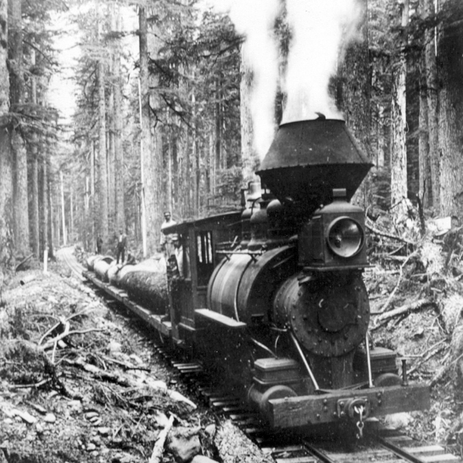
Loggers carried giant Noble fir cut on the slopes of Larch Mountain to the New Palmer Mill on logging railroads. This scene is from 1905

Old-growth Noble fir logs were milled at the original Palmer Mill site on the north slope of Larch Mountain. This scene is from 1896, when logging of the virgin Noble fir forests there was in its heyday

Palmer Mill was attached to the main mill by a long flume that followed Bridal Veil Creek, and it was the hub for a massive logging enterprise on Larch Mountain that felled most of the virgin Noble fir forests. Huge logs were first sent to Palmer Mill on a branched system of logging railroad spurs, then milled into rough lumber that was floated down the flume system to the Bridal Veil Mill for finishing into construction grade lumber.

Today, all but a few traces of the Palmer Mill are gone, and many of the Noble fir forests on Larch Mountain are approaching 100 years in age. The area somehow dodged the 2017 Gorge Fire that swept through vast areas of the Gorge, burning through thousands of acres of Noble fir forests in the Gorge high country. 

Noble fir in the age of Climate Change

Today, Noble fir country in the western Oregon Cascades is a checkerboard of clear cuts that mark the advent of National Forest logging that began on a commercial scale in the late 1940s. When these trees were cut, the catch phrase used to justify logging ancient forests was “sustained yield”, though sustained yield forestry never envisioned restoring ancient forests to their natural state. Instead, the management philosophy was to provide a continual supply of 60-100 year-old trees from plantations that could be repeatedly logged via a vast network of logging roads built in our forests from the late 1940s through the early 1990s.

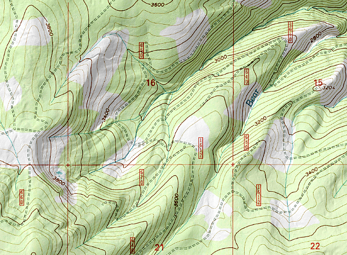
When 7.5 minute USGS maps were created in the 1950s and early 60s, there were already thousands of clear cuts on Forest Service lands that showed up on the new maps as a checkboard in heavily logged areas like Mount Hood’s Blue Ridge (shown here). Many more clear cuts followed, and sixty years later, these clear cuts are often overcrowded plantations of conifers that the Forest Service is now thinning through new timber sales

Despite the early bias against true firs, the wood produced by Noble fir eventually came to be valued for being light and strong, and was used during World War II in aircraft, as well as more common construction uses in windows, doors and paper production. This led to aggressive logging in the later years of the commercial timber boom of the 1950s-90s, when lower elevation forests had already been logged over, and high-elevation Noble fir forests were increasingly targeted. 

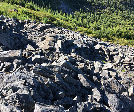
The Pacific Crest Trail follows the crest of this ridge near Lolo Pass, where heavily logged, high-elevation Noble fir forests have been slow to recover. These clear cuts are now 40-50 years old, and yet the stunted, crowded young plantation trees are still dwarfed by the groves of big, old-growth trees that were spared the chainsaw

Clearcutting on the steep, mountainous terrain where Noble fir grow was never sustainable, at least as measured in human lifetimes. The big, high elevation Noble fir forests sold off by the Forest Service were often hundreds of years old, with even the smaller-diameter trees well over a century old. There was never a chance to produce a rotating “crop” of trees at these elevations large enough to justify logging for generations to come, but that didn’t slow the rush to log these forests.

Instead, the logging boom finally peaked with the listing of the Spotted Owl and subsequent “timber wars” in the early 1990s, and it has never fully recovered, though some logging on our national forests continues today.

This Noble fir fell across the Timberline Trail recently, and was sawed out by trail crews. While it is only about 15” in diameter, a count of the annual growth rings revealed this tree to be over 160 years old, demonstrating how elevation and mountain conditions slow the growth of these trees

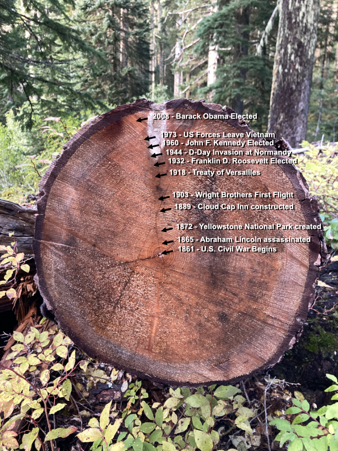
It’s easily to lose perspective on just how old the trees in our mountain forests really are. The above is a timeline of human events that unfolded since this tree took root as a Noble fir seedling on Mount Hood until a windstorm knocked it down in 2020. This tree is approximately 14 inches in diameter and 160 years old.

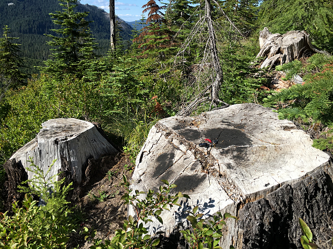
These stumps near Bennet Pass mark some of the oldest and largest Noble fir ever logged near Mount Hood, with some of these trees approaching 300 years old when they were cut. These stumps look like they might be a couple years old, with bark still intact. In fact, these trees were logged about 30 years ago, yet the Noble fir seedlings growing in this recovering clear cut are barely six feet tall

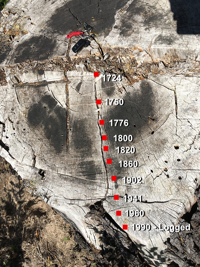
This is the same stump that appears in the foreground in the previous photo, with approximate dates according to tree rings. When it was cut, it has lived through more than a quarter of the first millennium.

The Bennett Pass clear cut (shown above) might look recent, given the intact condition of the stumps and the young Noble fir trees just getting established. Yet, this forest was cut nearly 30 years ago, as shown in the aerial photo pair (below). Thanks to its high elevation at over 4,000 feet, and resulting slow forest recovery, this logged area is still just beginning to reforest.

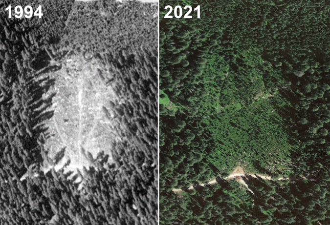
After nearly 30 years, this clear cut in an old-growth Noble fir forest near Bennett Pass is only beginning to recover

These examples are typical of logged Noble fir forests throughout the Mount Hood National Forest. They simply haven’t recovered at the pace the Forest Service assumed when logging was still king. Noble fir seedlings in these cut-over areas have often grown very slowly, reaching just 6 or 8 feet in height after 30 or 40 years of post-logging recovery. The slow recovery has also compounded the fragmentation effect on wildlife that depend on uninterrupted old-growth forest habitat.

Today, the Forest Service is grappling with the perfect storm of an aging, overbuilt system of spur roads from the heyday of commercial logging coupled with increasingly catastrophic forest fires resulting from climate change and a century of fire suppression. This is especially true in high-elevation Noble fir country, where clear cut plantations are especially vulnerable to summer drought and fire, and logging roads are impacted by severe winter conditions.

To meet these challenges, along with Congressional quotas for timber production that have always been unsustainable, the Forest Service has pivoted to forest thinning the thickets of young plantation trees in previously logged areas. It’s arguable that this strategy will help restore forests to a healthy state, but sadly, the Forest Service mission isn’t to restore a mature, healthy forest. Their goal is to bring more marketable logs to maturity, the primary management objective for much of Mount Hood National Forest.

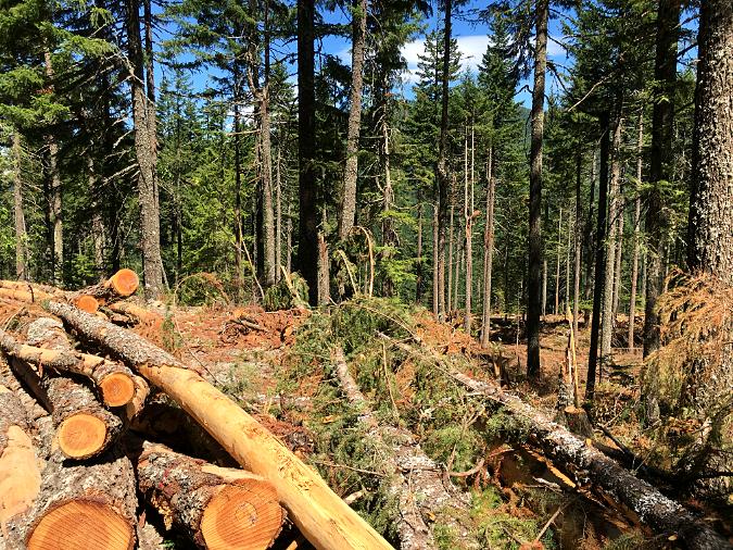
Forest thinning operation on Butcher Knife Ridge, north of Mount Hood, where roughly one third of the trees have been removed from a clear cut plantation to encourage a more diverse forest structure

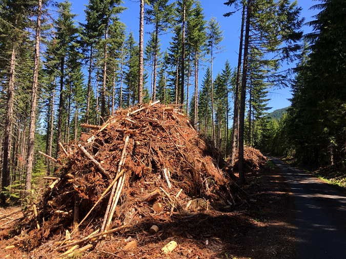
Forest thinning typically produces massive piles of woody debris, as seen here on Blue Ridge, just outside the Mount Hood Wilderness. Logging debris was historically burned as “slash”, though new uses are under development to make better use of this material as we enter the age of widespread forest thinning

The jury is out as to whether forest thinning improves the health of crowded plantations better than simply doing nothing, given the impact of heavy equipment on tree root systems and the forest understory.  The science does suggest that thinning can help as a preventative means for reducing forest fire severity, since it removes potential fuel from the forest. The benefit of thinning Noble fir plantations is less clear, however, since the species is already more vulnerable to fire than other conifers, and seldom survives fire.

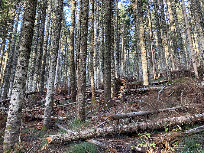
Noble fir also tolerate crowded conditions better than other conifers, presumably because these trees are so effective at colonizing burns and often form nearly pure stands in the process. Young Noble fir forests often have little understory beyond a carpet of beargrass because the trees are so closely spaced. But these pure stands have also evolved to self-thin over time, maturing to a more open canopy that allows huckleberry, rhododendron and other mountain understory species to thrive among more widely spaced, mature trees. In these forests, young Noble fir are also part of the understory, as the forest canopy continues to regenerate.

The following images show self-thinning in a young (about 80 years old) Noble fir forest on Bald Mountain, along the Timberline Trail. A recent windstorm selectively toppled the weakest among these trees, a timeless process that Noble fir don’t need our help with.

Recent downfall in a young stand of Noble fir on Bald Mountain are part of an ongoing, self-thinning process these trees have evolved for

Recent self-thinning event in a pure Noble fir stand on Bald Mountain. If it doesn’t burn, this protected forest inside the Mount Hood Wilderness will continue to self-thin, becoming an old-growth Noble fir forest in time

With logged high-elevation forests recovering very slowly, and high-elevation spur roads failing especially badly, and the mounting negative impacts of clear cutting, continued logging of our Noble fir forests simply isn’t a sustainable practice. A new management philosophy that centers on forest restoration and climate adaptation over timber extraction is long overdue.

Instead of waiting a century or more to produce marketable Noble fir saw logs, these recovering forests could be sold for credits on the carbon market, using their gradual recovery as carbon offsets for polluting industries. Over the long term, Noble fir have immense capacity for carbon capture and storage. Scientists studying the ancient Noble fir forests at the Goat March Research Natural Area, near Mount St. Helens, have determined this forest to have a biomass second only to the coastal Redwood forests of Northern California.

A mature, thriving Noble fir forest at the 4,000 elevation on Mount Hood, with a diverse mix of mature and younger trees, and a few wildlife snags 

Such a shift in Forest Service philosophy would not only help the global response to climate change, it would also yield a host of other benefits that high elevation forests in our region provide – a list that include critical wildlife habitat, cooler and more stable stream runoff for endangered salmon and steelhead and crucial water supplies for nearby communities that depend on mountain snowpack that forests help retain.

Mature Noble fir forest on Mount Hood, with towering old-growth trees mixed with younger trees and a dense understory

Such a shift in focus would also allow for the Forest Service to retire many of its deteriorating logging spur roads, and revenue from the sale of carbon credits could provide needed funding to do the work. Beyond the escalating cost to maintain them, these roads are notorious for triggering landslides and dumping sediments into streams when cut-and-fill roadbeds fail from plugged culverts or landslides. They also represent an increasing hazard in the form of human-caused forest fires and illegal dumping, as some of the worst lawless activity occurs on these remote roads where law enforcement simply cannot have a meaningful presence.

This road decommissioning work has already begun in the Mount Hood National Forest, though only in fits and starts, as it has thus far been driven by declining agency budgets more than an eye toward forest recovery and restoration. A focus on the broader outcomes of climate, water quality and fish habitat could speed up this important work with a new sense of urgency.

Where to see Noble fir

Want to see some of these trees close-up? One of the best and most accessible places is the short trail to Sherrard Point, which is the rocky summit pinnacle of Larch Mountain. The road to the summit picnic area and Sherrard Point trail is gated in the winter, but usually opens by early June. An easy, paved trail and series of stairsteps leads to the viewpoint.

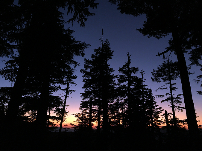
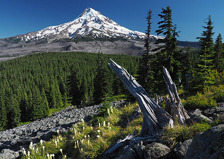
Noble fir giants at sunset in WyEast country

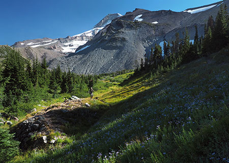
If you’d like a longer hike, the short, steep climb to the summit of Bald Mountain, near Lolo Pass, leads through some of the best old growth Noble fir in the Mount Hood area:

Bald Mountain from Top Spur

For an even longer hike, start from Lolo Pass and follow the Pacific Crest Trail to Bald Mountain, with much of the route through Noble fir forests:

Bald Mountain from Lolo Pass

Perhaps the best Noble fir forests in the Cascades are at Goat Marsh, near Mt. St. Helens. A short trail takes you into this fascinating research area and some of the largest known Noble fir trees in the world:

Goat Marsh Lake

Bald Mountain and Goat Marsh are snowed in during the winter months, but typically open by early June.

Enjoy!

_________________

Tom Kloster | November 2021

2017 Campaign Calendar!

mhnp_calendar01

[click here for a large image]

Each year since the Mount Hood National Park Campaign began in 2004, I’ve published a wall calendar to celebrate the many reasons why Mount Hood and the Columbia River Gorge should be our next national park. You can pick up a calendar here:

 2017 Mount Hood National Park Campaign Calendar

The calendar sales help cover some of the costs of keeping the campaign website and WyEast blog up and running. More importantly, they ensure that I continue to explore new places in the gorge and on the mountain, as each calendar consists exclusively of photos I’ve taken in the previous year. In this article, I’ll provide some of the stories behind the photos in the new Mount Hood National Park Campaign Calendar.

 The Calendar

Beginning in 2016, I’ve published the calendar at Zazzle, where the quality of printing and binding is much better than my former printer. The excellent print quality shows in the front cover (above), a view of the northwest face of Mount Hood from Cathedral Ridge where the color accuracy does justice to the vibrant cliffs on this side of the mountain.

An added bonus with Zazzle is the ability to include a full-color spread on the back of the calendar. As with the 2016 calendar, I’ve used this space to show off some of the flora I’ve photographed over the past year – and this year, I added berries and a butterfly to the mix, too:

mhnp_calendar02

[click here for a large image]

The monthly layout remains the same as last year, with a classic design that serves nicely as a working calendar for kitchens or offices:

 mhnp_calendar03

The finished calendar hangs 14 inches wide by 22 inches tall, with a white wire binding.

 The Images

The following is a rundown of the 12 images inside the calendar by month, with a link to a large version of each image, too. This year, I’ve posted especially large versions to allow for a closer look at these scenes (in a new window), and you can see them by clicking the link beneath each preview image.

The 2017 calendar begins with a chilly Tamanawas Falls for the January image. This impressive waterfall is located on Cold Spring Creek on Mount Hood’s east slope:

mhnp_calendar04

Tamanawas Falls in winter clothes

 [click here for a large image]

This popularity of this trail in winter has ballooned in recent years, from almost no visitors just a decade ago to traffic jams on winter weekends today.

The scenery explains the popularity. While the trail is lovely in the snow-free seasons, it’s downright magical after the first heavy snows in winter. The scene below is typical of the many breathtaking vistas along the hike during the snow season.

mhnp_calendar05

Cold Spring Creek gets just a little bit colder

It’s still possible to have the place to yourself, however. Go on a weekday, and you’re likely to find just a few hikers and snowshoers on the trail. Thus far, no Snow Park pass is required here – though that will surely come if the weekend crowds continue!

For February, I picked an image of Mount Hood’s steep north face, featuring the icefalls of the Coe and Ladd glaciers:

mhnp_calendar06

Mount Hood’s mighty north face from Owl Point

[click here for a large image]

This view is unique to the extent that it was taken from the Old Vista Ridge trail to Owl Point – a route that was reopened in 2007 by volunteers and provides a perspective of the mountain rarely seen by most visitors.

 For March, I selected an image of Upper Butte Creek Falls:

mhnp_calendar07

Lovely Upper Butte Creek Falls in spring

[click here for a large image]

This is on the margins of Mount Hood country, but deserves better protections than the Oregon Department of Forestry (ODF) can ever provide, given their constitutional obligation to log state forests to provide state revenue.

While ODF has done a very good job with the short trails that reach the waterfalls of Butte Creek, the bulk of the watershed is still heavily managed for timber harvests. Who knows, someday maybe it will be part of a Mount Hood National Park? It’s certainly worthy.

On this particular trip last spring, I returned to the trailhead to find these notes on my windshield:

mhnp_calendar08

Our future is in good hands!

Not much damage to the car, and the note more than made up for it! I did contact Jesse, and ended up speaking to his dad. I thanked him for being an excellent parent. With dads (and moms) like this, our future is in good hands!

For April, I picked this scene from Rowena Crest at the height of the Balsamroot and Lupine bloom season:

mhnp_calendar09

Rowena Crest in April splendor

[click here for a large image]

Just me and a few hundred other photographers up there to enjoy the wildflowers on that busy, sunny Sunday afternoon! Look closely, and you can see a freight train heading west on the Union Pacific tracks in the distance, lending scale to the enormity of the Gorge.

For the May image, I chose the classic scene of Punch Bowl Falls along the popular Eagle Creek Trail in the Gorge:

mhnp_calendar10

Punch Bowl Falls in spring

 [click here for a large image]

The spring rains faded quickly this year, resulting in much lower flows along Eagle Creek by the time spring greenery was emerging, making it less chilly to wade out to the view of the falls. To the right of the falls you can also see the latest downfall to land in front of the falls. To my eye, this adds to the scene, so I see it as a plus.

This isn’t the first big tree to drop into the Punch Bowl in recent years. In the mid-2000s, another large tree fell directly in front of the falls, much to the frustration of photographers:

mhnp_calendar11

Punch Bowl Falls in 2006 with an earlier fallen tree in front of the falls

 That earlier tree was flushed out a few years ago, only to be replaced by the current, somewhat less obtrusive downfall a couple of years ago. Here’s a wider view showing this most recent addition, including the giant root ball:

mhnp_calendar13

Gravity at work once again at Punch Bowl Falls

This pattern will continue as it has for millennia, as other large Douglas fir trees are leaning badly along the rim of the Punch Bowl. They eventually will drop into the bowl, too, frustrating future generations of photographers!

 The Punch Bowl, itself, changes over time. This early view from the 1920s shows a lot more debris inside the bowl compared to recent decades, possibly from erosion that followed an early 1900s forest fire in the Eagle Creek canyon:

mhnp_calendar12

Punch Bowl Falls in the 1920s

Look closely and you can see flapper-era hikers on the rim of the bowl and several rock stacks left by visitors on the gravel bar – some things never change!

The June image in the new calendar is the opposite of Punch Bowl Falls. While thousands visit Eagle Creek each year, the remote spot pictured below is rarely visited by anyone, despite being less than a mile from Wahtum Lake and the headwaters of Eagle Creek. This view is from a rugged, unnamed peak along Waucoma Ridge, looking toward another unnamed butte and snowy Mount Adams, in the distance:

mhnp_calendar14

A place of ancient significance, yet lost in our modern time

[click here for a large image]

For the purpose of keeping track of unnamed places, I’ve called the talus-covered butte in the photo “Pika Butte”, in honor of its numerous Pika residents. The peak from which the photo is taken is an extension of Blowdown Ridge, a much-abused, heavily logged and mostly forgotten beauty spot that deserves to be restored and placed under the care of the National Park Service.

The view of “Pika Butte” was taken while exploring several off-trail rock knobs and outcrops along Blowdown Ridge, but what made this spot really special was stumbling acxross a cluster of Indian pits (sometimes called vision quest pits). One pit is visible in the lower left corner of the wide view (above) and you can see three in this close-up view from the same spot:

mhnp_calendar15

If only these stones could tell us the story behind the mystery!

Nobody really knows why ancient people in the region made these pits, but it’s always a powerful experience to find them, and imagine the lives of indigenous peoples unfolding in the shadow of Mount Hood. These pits had a clear view of the Hood River Valley, with the Columbia River and Mount Adams in the distance. Indian pits often feature a sweeping mountain or river view, adding to the theory that they were built with a spiritual purpose.

For July, another photo from Owl Point along the Old Vista Ridge trail. This wide view shows some of the beargrass in bloom on the slopes of Owl Point on a sunny afternoon in July:

mhnp_calendar16

Mount Hood fills the skyline from Owl Point

[click here for a large image]

Since this historic trail was adopted by volunteers in 2007, it has become increasingly popular with hikers. Several geocaches are located along the way, as well as a summit register at Owl Point with notes from hikers from all over the world. A few recent entries among hundreds in the register show the impact that this amazing “new” view of Mount Hood has on visitors to Old Vista Ridge:

mhnp_calendar17

mhnp_calendar18

mhnp_calendar19

In a few months I’ll share some exciting news about the Old Vista Ridge Trail, Owl Point and the surrounding areas on Mount Hood’s north slope. Stay tuned!

For August, I picked another scene on the north side of the mountain, this time at iconic Elk Cove along the Timberline Trail:

mhnp_calendar20

Swale along Cove Creek in Elk Cove

[click here for a large image]

The hiker (and his dog) approaching me in this photo stopped to chat, and I was surprised to learn that he was a regular reader of this blog!

As we talked about the changes to the cove that came with the 2011 Dollar Lake Fire (that burned the north and west margins of the cove), he mentioned finding the foundation from the original Civilian Conservation Corps (CCC) shelter in the brush near Cove Creek! We crossed the creek and in a short distance, came to the unmistakable outline of the shelter:

mhnp_calendar21

The old Elk Cove shelter foundation is surprisingly intact – but hidden

This structure was once one of several along the Timberline Trail, but fell into disrepair following avalanche damage sometime in the 1950s or early 1960s. This image is apparently from the mid-1960s, showing the still somewhat intact ruins of the shelter:

mhnp_calendar22

The beginning of the end for the Elk Cove shelter in the 1960s

The location of the shelter was a surprise to me, as I had long thought the building was located near a prominent clearing and campsite near the middle of Elk Cove. Now that I know the exact location, I plan to reproduce the 1960s image on my next trip to the cove, for comparison.

For September, I chose a quiet autumn scene along Gorton Creek, near the Wyeth Campground in the Columbia Gorge (below). This is a spot I’ve photographed many times, just downstream from popular Emerald Falls:

mhnp_calendar23

Pretty Gorton Creek in the Wyeth area of the Gorge

[click here for a large image]

This area has a fascinating history, as today’s Wyeth Campground is located on the grounds of Civilian Public Service Camp No. 1, a World War II work camp for conscientious objectors. The men serving at this camp built roads and trails throughout the Gorge, in addition to many other public works projects. The camp operated from 1941-1946. You can learn more about the Wyeth work camp here.

The October scene is familiar to anyone who has visited the Gorge. It’s Multnomah falls, of course, dressed in autumn colors:

mhnp_calendar24

A bugs-eye view of Multnomah Falls?

[click here for a large image]

If the photo looks different than your typical Multnomah Falls view, that’s because I blended a total of eight images to create a horizontal format of this very vertical falls to better fit the calendar. Here’s what the composite looked like before blending the images:

mhnp_calendar25

To young photographers of the digital age, blending photos is routine. But for those of us who started out in the age of film photography and darkrooms, the ability to blend and stack images is nothing short of magical – and fun! While younger photographers are increasingly exploring film photography as a retro art, the digital age is infinitely more enjoyable than the days of dark rooms, chemicals and expensive film and print paper for this photographer.

I paused before including a winter-season photo of Wahclella Falls for the November calendar image (below). Why? Because I’ve used a photo from this area in nearly every calendar since I started assembling these more than a decade ago. It’s my favorite Gorge hike – I visited Tanner Creek and Wahclella Falls five times in 2016 – and have photographed this magnificent scene dozens of times, and yet it never gets old.

mhnp_calendar26

Wahclella Falls is a winter spectacle!

[click here for a large image]

I decided to include this Wahclella Falls scene because it captured a particularly wild day on Tanner Creek last winter. The stream was running high, filling the canyon with mist and seasonal waterfalls drifted down the walls of the gorge on all sides.

The huge splash pool at the base of the falls was especially wild – more like ocean surf than a Cascade stream, and if you look closely, you can also see a hiker braving the rain and cold to take in this view:

mhnp_calendar27

Roaring falls, big boulder… and tiny hiker

I also liked the turbulent stream below the falls, which also boiled more like ocean surf than a mountain stream:

mhnp_calendar28

Tanner Creek comes alive in winter

 So, another calendar featuring Wahclella Falls? Yes, and it certainly won’t be the last. This is among the most magical places in the Gorge – or anywhere!

 Finally, for the December image I selected a photo from my first official attempt at capturing the Milky Way over Mount Hood. This view is across Laurance Lake, on the north side of the mountain:

mhnp_calendar29

Milky Way rising over Laurance Lake and Mount Hood

[click here for a large image]

The glow on the opposite side of the lake is a campfire at the Kinnikinnick Campground, and was just a lucky addition to the scene. While we waited for the Milky Way to appear, there were several campers arriving, making for some interesting photo captures. With a 30-second exposure set for stars, this image also captures the path of a car driving along the south side of the lake to the campground:

mhnp_calendar30

Headlights and campfires in a Laurance Lake time exposure

My tour guide and instructor that evening was Hood River Photographer Brian Chambers, who I profiled in this WyEast Blog article in June. Thanks for a great trip, Brian!

mhnp_calendar31

The author with Brian Chambers somewhere under the Milky Way

So, if you’re looking to support the blog and Mount Hood National Park campaign or just have an ugly fridge to cover, you can order the new calendar on Zazzle.

_________________

…and finally, given the unusual events in our recent national election, some reflections on what it might mean for Mount Hood and the Gorge…

Post-election deju vu: back to the future..?

mhnp_calendar32

Viewed through the lens of protecting public lands and the environment, the presidential election results on November 8 are discouraging, at best. For those of us who have voted in a few elections, it feels a lot like the Reagan Revolution of 1980.

So, the following is a bit of speculation on what lies ahead based upon what we’ve been through before, but with the caveat that unlike that earlier populist surge against government, the environmental agenda of the coming Trump administration is somewhat less clear and appears less ideologically driven.

Ronald Reagan’s vision for government brought a very specific mission to dismantle environmental regulations and open up public lands to commercial interests. To carry out the mission, President Reagan appointed the highly controversial James Watt to head the Department of Interior, and the nearly as controversial Anne Gorsuch to run the EPA. John Block was tapped to head of the Department of Agriculture (which oversees the U.S. Forest Service). Watt and Gorsuch were attorneys, Block a farmer who had entered politics as an agriculture administrator in the State of Illinois.

mhnp_calendar33

James Watt’s radical vision for our public lands threatened to derail Ronald Reagan in his first term

Watt and Gorsuch became infamous for their open disdain for conservationists and the agencies they were appointed to administer. Watt was the Reagan administration’s sympathetic gesture to the original Sagebrush Rebellion. Block focused primarily on an ideological rollback of farm subsidies and programs that dated to the Dust Bowl, and that would eventually be his downfall.

The important lesson is that all three rode in with a “revolution” mandate, and over-reached in their zeal to rewrite American policy overnight. The blowback was instant, and though they did harm our conservation legacy during their embattled tenures, they didn’t have the lasting impact many had feared. Both Watt and Gorsuch were forced to resign before the end of President Reagan’s first term, and Block resigned in the first year of Reagan’s second term.

mhnp_calendar34

Even Readers Digest covered the EPA Superfund scandal that drove Anne Gorsuch out of office!

Gorsuch was eventually pushed out by Reagan for attempting to conceal EPA Superfund files from Congress as part of an unfolding scandal, becoming the first agency head to be cited for contempt of Congress. Before the scandal drove her from office, Gorsuch became Anne Gorsuch Burford when she married James Burford, Reagan’s Bureau of Land Management (BLM) chief, further fueling concern about whether environmental protections could be objectively enforced on BLM lands.

John Block lasted five years, but was pushed out in early 1986 as the worst farm crisis since the Great Depression unfolded under his tenure. Watt left in more spectacular fashion after stating (apparently a joke) that an ideally balanced advisory panel would include ”a black, a woman, two Jews and a cripple.” (and in the age of Google, he has been deservedly forgotten, with the more consequential James Watt – inventor of the steam engine – reclaiming his name in history).

mhnp_calendar35

Bloom County has some fun with Oregon’s Rajneeshee saga… and Ronald Reagan’s failed cabinet appointees

Will history repeat itself? We’ll see, but there is no reason to assume that the conservation community – and, importantly, the American public – will be any less motivated to speak out if the Trump administration attempts a similar rollback on public land and environmental protections to what the Reagan Administration attempted.

Yes, there will be lost ground, but there will also be unexpected gains. That’s our system. Recall that the same President Reagan who brought James Watt to the national stage also signed the Columbia River Gorge Scenic Area Act into law thirty years ago, on November 17, 1986 (famously “holding his nose”, in his words). In his first term, President Reagan signed the Oregon Wilderness Act into law on June 26, 1984, creating 22 new wilderness areas covering more than 800,000 acres.

As President Obama said in his reflection on the election, “democracy is messy”. He also reminded the president-elect that our system of governance is more cruise ship than canoe, and that turning it around is a slow and difficult process, no matter what “mandate” you might claim. That is by design, of course.

…and the WyEast Blog in 2017..?

Looking ahead toward 2017, I hope to keep up my current pace of WyEast Blog articles as I also continue my efforts as board president for Trailkeepers of Oregon, among other pursuits. And spend time on the trail, of course!

mhnp_calendar36

The author somewhere in Oregon’s next national park…

As always, thanks for reading the blog, and especially for the kind and thoughtful comments many of you have posted over the years. The blog is more magazine than forum, but I do enjoy hearing different perspectives and reactions to the articles.

Despite the election shocker this year, I’ve never felt better about Mount Hood and the Gorge someday getting the recognition (and Park Service stewardship) they deserve! That’s because of a passionate new generation of conservations are becoming more involved in the direction of our nation and our public land legacy. The 2016 election seems to have accelerated the passion this new generation of stewards brings to the fight.

Our future is in very good hands, indeed.

 See you on the trail in 2017!

 Tom Kloster | Wy’East Blog


Proposal: Waucoma Bicycle Backcountry

It’s no secret that mountain bikes have been relegated to second-class status when it comes to recreation trails. They’re not allowed in designated wilderness areas, and even with the special set-asides for mountain bikes called out in the recent Mount Hood Wilderness additions, the trail options around the mountain are limited.

It’s also true that bikes and hikers don’t always mix well. Since I’m both a hiker and cyclist, I’m probably more comfortable than most hikers when it comes to shared trails. I love to hike and bike the Surveyor’s Ridge Trail, for example, but most hikers shy away because of its popularity among mountain bikers.

The view toward Mount Hood from Blowdown Mountain

This article is a proposal for something a little different for mountain bikers: the concept is to convert fading logging roads in a scenic area directly adjacent to the Mark O. Hatfield Wilderness to become a dedicated bicycle backcountry. In addition to providing an exciting set of mountain biking trails, the concept would specifically allow for bikepacking — overnight camping at a several destinations that would be bike-in, only.

Most importantly, this new destination would be close to both Portland and the mountain biking hub of Hood River, where bicycle tourism has become an important part of the recreation economy.

[click here for a large, printable map]

The best part of this proposal is that it wouldn’t take much to put the network together. Converting fading roads and constructing just 2.9 miles of new trail (shown in yellow on the map, above) would create a 25-mile bike network of bike-only trails (shown in blue) in an area with terrific scenery, creating as close to a wilderness experience as you can have while on two wheels.

The Proposal

The proposed bicycle backcountry would straddle the high country along Waucoma Ridge, about ten miles due north of Mount Hood. Two main trailheads would serve the backcountry: a new trailhead would be constructed in the headwaters valley of Divers Creek, serving as the primary entry into the bicycle backcountry. The existing Wahtum Lake trailhead would serve as overflow. Both are accessed on paved roads. A third, more remote trailhead would be located at the headwaters of Green Point Creek, accessed by a primitive road.

The view toward Indian Mountain from Waucoma Ridge

Trails

The proposed network has three kinds of bicycle facilities: converted logging roads (dashed blue on the map) functioning as single or dual track routes, new single track bike trails (dashed yellow) and striped bikeways (solid blue) on a short segment of paved Wahtum Lake Road that serves as a critical connection in the proposed network.

The focus of the network is on bicycle loop tours. From the proposed new trailhead, dozens of tour variations are possible, thanks to the dense network of old roads in this area, and the potential to connect and convert them. One out-and-back trail exists, following the Waucoma Road to Indian Mountain (under this proposal, the road would be gated to motor vehicles at the Wahtum Lake trailhead)

Washington’s big volcanoes fill the skyline on the slopes of Indian Mountain

The main focus of the new trail system would be Blowdown Mountain, a surprisingly rugged shield volcano whose gentle summit ridge belies a rugged east face, featuring a craggy volcanic plug rising above a series of forested glacial cirques. An attractive spur road traverses the entire summit ridge of Blowdown Mountain, and would form the spine of the trail network in this part of the bicycle backcountry.

Three small lakes are located in glacial cirques on the northeast flank of the mountain, and views from the high ridges include nearby Mount Hood, to the south, and the high peaks of the Hatfield Wilderness, to the north. The big Washington State volcanoes complete the scene on the northern skyline.

Spring wildflowers line the rustic route Indianhead Ridge with Mount Hood in the distance

The western part of the proposed network focuses on Indianhead Ridge, another high shoulder of the Waucoma Ridge complex, extending south toward the West Fork Hood River. The proposed trail network in this section would include extensive ridge top rides, with panoramic views of Mount Hood and the steep east face of Indian Mountain.

This part of the bicycle backcountry would also encompass the Waucoma Ridge Road, gating and converting the route to bike-only use except for Forest Service vehicles. The road leads through exceptionally scenic terrain, including the former lookout site on Indian Mountain, and fine views into the Eagle Creek valley, within the Hatfield Wilderness. The road, itself, forms the Hatfield Wilderness boundary.

Beautiful Scout Lake in the proposed Waucoma bicycle backcountry

This section of the proposal network also includes seldom-visited Scout Lake, a beautiful forest lake that has historically been stocked with brook trout by the Oregon Department of Fish and Wildlife (ODFW).

Campsites

Five bikepacking campsites are proposed along the new trail circuit. One is simply the existing Indian Springs Campground, an excellent but largely forgotten primitive campground in need of repair. New campsites would be located at Ottertail Lake, the Talus Pond near Gray Butte, Mosquito Lake and Scout Lake, with each offering 5-15 tent sites.

Unlike the nearby Hatfield Wilderness, bikepacking campsites in the new backcountry would feature rustic picnic tables, fire rings and secure hitching racks for bicycles — features that aren’t allowed in a wilderness area, but would be welcome additions in the bicycle backcountry.

Mosquito Lake basin from Blowdown Mountain, with Mt. Defiance and Mt. Adams in the distance

What would it take?

The viability of this proposal is in its simplicity: less than three miles of new trail would open a 25-mile network, with dozens of loop options that could be tailored to the ability of individual mountain bikers. Most of the work required could be done with the help of volunteers, from trail building and campsite development to signage and ongoing maintenance. Some heavy equipment would be required to develop the new, main trailhead and decommission vehicle access to converted roads.

The view across Ottertail Lake basin toward Tomlike Mountain and Mt. St. Helens

Of course, the proposal would also require the Mount Hood National Forest (MHNF) to fully devote the Waucoma Ridge area to quiet recreation. A few years ago, that would have been unlikely, but in recent years, the agency has not only adopted plans to phase out hundreds of miles of logging roads, but also a policy to focus OHV use in a few, very specific areas of the forest. The recent developments could move this proposal into the realm of the possible if sufficient support exists for a bicycle backcountry.

It would take dedicated support from the mountain biking community to make the case to the Forest Service, ideally in a partnership with the agency that would include volunteer support in developing the trail system.

Cyclist on the new Sandy Ridge trail system, an example of collaboration between the USFS and bicycle advocates (City of Sandy)

The good news is that mountain bicycling organizations are already working hard to develop trails elsewhere in the Mount Hood region (such as the Sandy Ridge trail complex, pictured above) and hopefully would find this proposal worth pursuing. If you’re a mountain biker, you can do your part by forwarding this article to like-minded enthusiasts, or your favorite mountain biking organization. It’s a great project just looking for a champion!
____________

Bikepacking Resources

Bikepacking.net is an online community that focuses on off-road touring, away from cars, with great information on gear, routes and trip planning.

The Adventure Cycling Association posted this helpful article on how to pack for your bikepack trip.

Another good article on what to pack for your bikepack on the WhileOutRiding.com blog.

The International Mountain Bicycling Association is the premier organization and advocate for backcountry bicycling.

In the Mount Hood region, the Northwest Trail Alliance is the IMBA Chapter doing the heavy-lifting on bicycle trail advocacy.