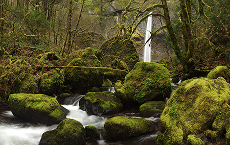
McCord Creek takes on more subtle hues in winter
Beautiful McCord Creek boasts a pair of impressive waterfalls that are among the most photogenic in the Columbia River Gorge. The falls are tucked into John B. Yeon State Park, a lesser-known park located about halfway between Multnomah Falls and Cascade Locks.
The rustic CCC-era trails to McCord Creek’s waterfalls have been “discovered” in recent years from spring through fall by crowds of weekend hikers. Yet, the area is surprisingly un-crowded during the wet winter months, from late fall through early spring, and the muted winter tones are just as beautiful.
The area also has a long and fascinating human history that is on display throughout the hike, if you know where to look. This article provides a guide to both the trail and the history of the McCord Creek area.
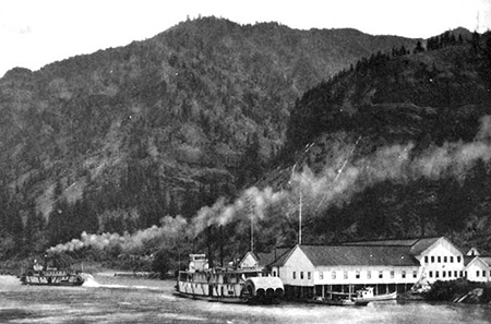
Frank Warren’s salmon cannery (site of today’s Warrendale) in 1902
The human history in this part of the Gorge stretches back thousands of years, as the river was home to a thriving culture of Native American peoples.
The Upper Chinookan people of the Columbia River Gorge fished the legendary autumn salmon runs and picked huckleberries and other wild fruits and forage before moving away from the river during the often harsh winters that we know so well today. An especially elaborate example of the mysterious stone pits thought to be built by native people for ceremonial purposes can still be found high above McCord Creek, on Wauneka Point.
White settlement came to the Gorge in the 1800s, and ushered in an era of profound tragedy for the native people, with epidemics of measles and other European diseases decimating native populations, and white settlement displacing native peoples from places they had inhabited for millennia. It’s an uncomfortable reality to confront today, but also important to never forget as we try to understand our history.
White settlers were equally destructive for the land and natural resources, as well. In a matter of a few decades, the Gorge slopes were almost completely logged of ancient forests and giant fish wheels built along the river were part of the commercial overfishing that nearly collapsed the salmon runs that had sustained Native Americans here for thousands of years.
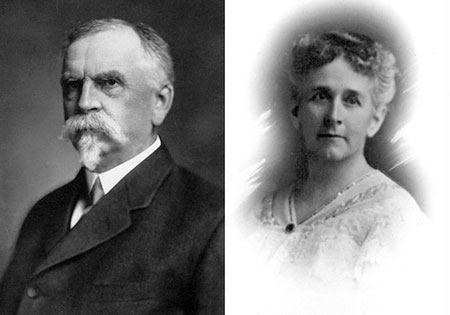
Frank and Anna Warren in the early 1900s
Frank Warren was among the prominent industrialists operating fish wheels to supply a cannery he built at Warrendale. Today, only a residential district by that name remains to mark the site, just downstream from McCord Creek.
In the heyday of the Columbia River canneries at the turn of the 20th Century, canned salmon from the Warren packing company was exported around the world, and Columbia River canned salmon was as ubiquitous as cans of tuna are in our supermarkets today. But overfishing by gill nets, fish traps and fish wheels nearly destroyed the salmon runs. Fish wheels were finally outlawed by the 1930s, as the canning industry on the Columbia continued its decline. The last salmon cannery on the river closed in the 1970s.
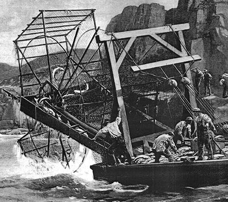
1890s Harpers Weekly illustration of a Columbia River fish wheel
Warren’s packing business made him a millionaire, and he and his wife Anna celebrated their 40th anniversary in style with a 3-month European tour in 1912. For their return trip, the Warrens reserved a first-class stateroom on the maiden voyage of the RMS Titanic.
Anna Warren’s riveting account of the Titanic disaster in April 1912 was featured in the Morning Oregonian twelve days after the incident, creating a local sensation. Her tragic story recounted how her husband Frank helped her onto a lifeboat, with Anna assuming he had followed her in. Instead, when she looked back, she saw Frank helping other women into the boats.
At the time Anna Warren’s account was published, Frank Warren’s fate was still unknown, but he was later identified as among the more than 1,500 who perished that night. Anna Warren was one of just 710 survivors of the disaster.
Myron Kelly’s pulp mill at McCord Creek in the 1890s
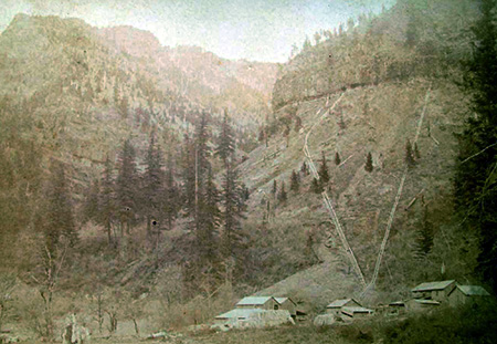
At about the same time that Frank Warren was operating his Warrendale cannery in the late 1800s, another settler by the name of Myron Kelly was operating a small pulp mill near McCord Creek. Kelly’s mill used a pair of 400-foot long, riveted steel penstocks to power the pulp manufacturing. Though the mill is long gone, portions of the penstocks still survive. They are clearly visible in the 1890s view of the mill, above.
The penstocks were fed with water from McCord Creek, diverted from above the waterfalls, and routed to the penstocks along the cliff-top ledge we now use as a hiking trail. Kelly used a natural break between basalt layers to blast out the ledge, and hardware from the pipe system is still found throughout the cliff area today. Black cottonwood trees — the same we see lining the river today — provided the raw material for making pulp.
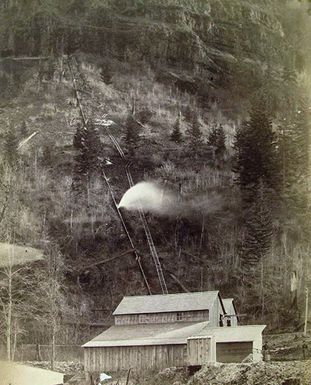
This 1890s photo shows water spouting from the long penstock that drove Myron Kelly’s pulp mill
Surviving portions of the two penstocks are prominently crossed by the trail to Upper McCord Creek Falls, along with other relics sprinkled through the forest. The large wood water cistern located near McCord Creek trailhead is not from the Kelly pulp mill era, surprisingly, and was added later to supply water to area homes.
The early industrial settlements in the Gorge relied on railroads and ships for transport, as there was no road until the early 1900s. That changed in 1916, when the new Columbia River Highway was dedicated with much fanfare. The highway is still famous, cherished by millions of visitors over the past century for its careful attention to the landscape and surrounding Gorge scenery. Perhaps most iconic are its string of graceful bridges.
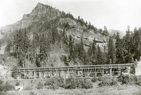
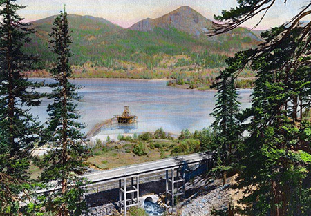
Columbia River Highway bridge at McCord Creek under construction in 1915 (Wauneka Point towers above)
The original highway bridge at McCord Creek was completed in 1915, and while it wasn’t as graceful as some of the more famous arched bridges, it was nonetheless a spectacular structure. Early travelers not only had a front-row view of Elowah Falls on McCord Creek, but also a sweeping vista across the Columbia to Beacon Rock and the mountains that rise along the Washington side of the Gorge.
The original McCord Creek Bridge was among the longest along the old highway at 365 feet. The old structure was durable enough to be incorporated into the first “modern” highway in the Gorge in the 1950s, when much of the original Columbia River Highway was bypassed. The original McCord Creek Bridge was simply expanded to carry the wider road, and later a twin structure was built to accommodate the development of today’s freeway. The original bridge structure was finally replaced in 1987 with a new bridge, after 70 years of service.
Completed McCord Creek bridge in 1915, with the Kelly pulp mill conduits visible in the cliffs high above, and Elowah Falls behind the bridge
The new McCord Creek Bridge in the 1920s as it appeared from the cliffs above Elowah Falls
By the 1930s, the New Deal programs of Franklin D. Roosevelt’s national recovery effort brought the Civilian Conservation Corps (CCC) to the Gorge. Many of the trails we enjoy today were built — or rebuilt — by the CCC, including the McCord Creek trail.
The CCC crews were expert trail builders, and made quick work of the steep Gorge slopes with carefully graded switchbacks constructed with miles of hand-built, rustic stone retaining walls. The original trail at McCord Creek began at the east end of the old highway bridge, traversed to dramatic viewpoints of Elowah Falls, then crossed McCord Creek to climb the east shoulder of the canyon to the upper falls.
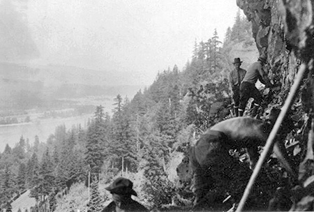
Civilian Conservation Corps crew building the catwalk section of the McCord Creek Trail in 1936 (highway bridge visible in lower left corner of photo)
It was here that the CCC trail builders seized upon the route of Myron Kelly’s penstock conduit around the towering cliffs above Elowah Falls. The photo above shows crews clearing the ledge in 1936 to repurpose the route as a bold new hiking trail.
The galvanized steel handrails that now give some assurance to hikers along this airy catwalk are not mentioned in a fairly detailed 1936 Daily Oregonian story describing the new trail. These were probably added in the 1950s, when similar railings were installed in other parks around the Gorge — and it’s easy to see why this retrofit was needed as you walk along the 300-foot brink!
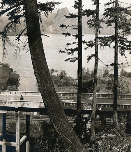
Beacon Rock and the McCord Creek Bridge as they appeared from the original CCC trail to Elowah Falls
The 1936 Daily Oregonian article also mentions one of the more famous features of the area during the early days of the Columbia River Highway. The McCord Creek Bridge construction in 1915 had unearthed a large petrified tree near the east end of the bridge, embedded in the road cut. The tree became a popular feature along the old road, and also marked the start of the McCord Creek trail.
The whereabouts of the petrified tree are unknown today, as it must have been moved (or destroyed) when the modern highway was constructed in the 1950s. Curious Gorge author Scott Cook speculates that it may have found its way to Cascade Locks, where a petrified log now sits on display at the Marine Park. Petrified logs are not uncommon in this part of the Gorge, however, so the fate of this most famous log may never be known for certain.
Update: Scott Cook has located the petrified tree! It was apparently shipped to the University of Oregon Natural History Museum when the modern freeway was built, and placed next to a replica of the Willamette Meteorite. Scott tells me that ODOT historic highway staff approached museum officials a couple of years ago about moving the tree back to its original home (of a few million years), but it’s unclear if that idea gained any traction. The beautiful new McCord Creek bridge sure seems like an appropriate home for the old tree! Stay tuned – I’ll report any news on the subject as it comes.
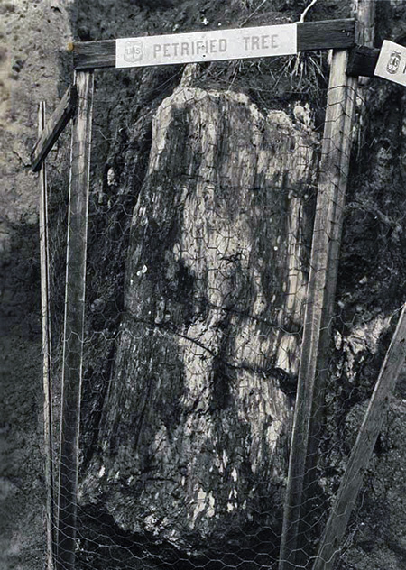
This petrified log was located at the east end of the McCord Creek bridge, near the original trailhead
The human history of the McCord Creek area has taken another dramatic turn in recent years with the construction of the Historic Columbia River Highway (HCRH) State Trail. The new bike and pedestrian route is an ambitious, decades-long effort by the State of Oregon to restore lost sections of the original highway, eventually re-connecting the entire original route from Troutdale to The Dalles.
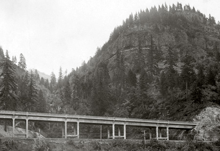
In 2012, construction of the HCRH State Trail section from John B. Yeon State Park to Tanner Creek was in full swing, and featured a handsome new bridge over McCord Creek that rivals the original highway bridges in its design and attention to detail.
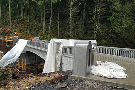
The new Historic Columbia River Highway state trail bridge at McCord Creek under construction in 2012
The completion of this new segment of the HCRH State Trail has opened loop high opportunities in the McCord Creek area, as well as the opportunity to bike and hike — as described below in this article.
Exploring the Trail Secrets of McCord Creek
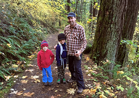
A young family enjoying the McCord Creek Trail in late autumn
Now that you know some of the history of McCord Creek, it’s time to explore the trail! This is a half-day hike for most, so makes for a great option during the short days of winter, when most higher elevation trails are snowed in. It’s also a great family hike, with lots to look at and modest grades throughout, thanks to careful design by its CCC builders.
Like most Gorge trails, the hike has cliffs, poison oak and ticks, so keep an eye on small kids, leash your dog, learn to identify and avoid poison oak and do a tick check when you get home. One of the added advantages of doing this hike during the winter months is that poison oak leaves have dropped, greatly reducing the possibility of bringing home an itchy rash from your hike! Ticks are also much less active in winter — and not particularly prevalent in this particular area — though you should always do a tick check after hiking in the Gorge.
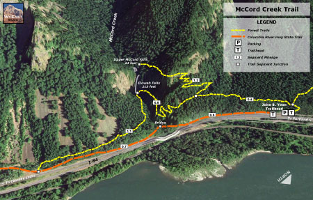
McCord Creek Trail map
[click here for a larger, printable map]
The hike starts at the John B. Yeon trailhead (driving instructions at the end of this article), and after passing the old wooden cistern mentioned above, you immediately reach the first poorly-signed junction. The trail to the right heads off to Nesmith Point, so continue straight (left) instead, past an empty signpost and traverse above the trailhead parking area.
Soon, the trail begins a very gradual climb on what is actually an old roadbed, now just a very wide and rustic path. This section of trail was opened sometime after the modern freeway was constructed in the 1950s, and the original trailhead for the McCord Creek trail relocated from its old location on the east side of the creek.
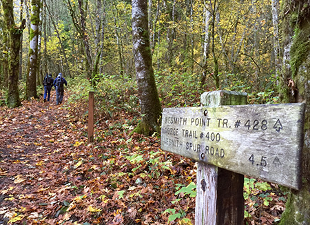
The first of several confusing signs along the trail…
At about one-half mile from the trailhead, the old roadbed ends at a “T” junction with the original CCC trail and another confusing signpost. From this point in the hike, the trip has two forks, with up-and-back spurs to follow, one to each of the two waterfalls. The best way to enjoy the hike is to go right at this junction, and continue climbing toward Upper McCord Creek Falls as your first destination.
As you climb the 1.2 miles to the upper falls, watch for the beautifully constructed stone retaining walls that line much of the trail. They are now cloaked in moss and licorice fern, but have held up amazingly well since the stones were first placed almost 80 years ago by CCC workers.
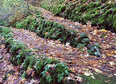
Legacy of the CCC – rustic stone retaining walls like these are found throughout the hike
After several switchbacks through steep forest, you will encounter the remains of the old pulp mill penstock pipes. One is located at the end of a switchback, the other crosses the main trail.
Look closely at the second pipe, and you can see the doomed efforts of some early trail crew to actually cut through the surprisingly solid pipe! Up close, you can also see the thousands of rivets used to assemble pipes of this kind in the late 1800s in a way that could withstand the intense water pressure.
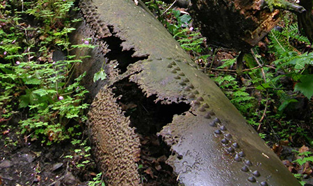
Myron Kelly’s sturdy penstock pipes still survive along the upper trail
The trail passes through a couple more switchbacks beyond the penstock pipes before reaching the spectacular and exhilarating catwalk section, some 300 dizzying feet above McCord Creek. The handrail makes this section very safe, so take the time to look for traces of the old mill conduit that once carried water from McCord Creek around this ledge — there are old bolts and bits of pipe if you watch closely.
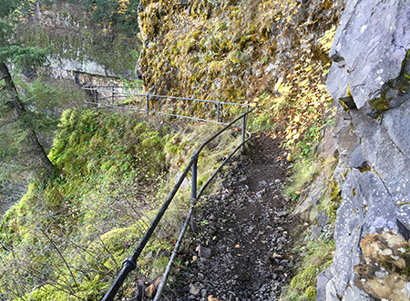
The catwalk section has reassuring railing atop the 300-foot cliffs
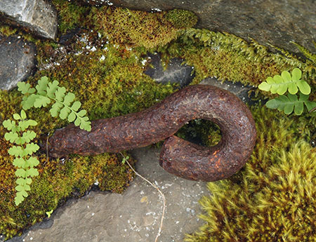
Traces of the old waterworks are still visible on the upper trail
The views from the cliffs are also impressive. On most days, Aldrich and Table Mountains on the Washington side of the Columbia River dominate the horizon, but on clear days, the very top of Mount Adams can also be seen. Further on, the catwalk section of trail also allows a birds-eye view of Elowah Falls dropping into its huge amphitheater, far below.
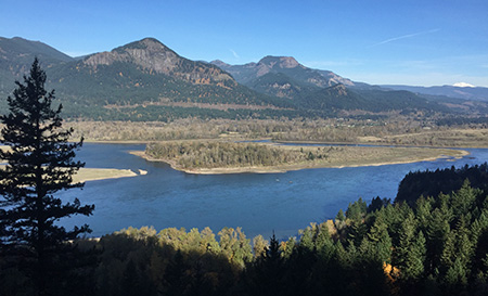
Sweeping cliff-top views stretch across the Columbia to Aldrich and Table Mountains — and the very top of Mount Adams, in the distance
If you happen to be hiking the trail during the busier months of May or early June, you’ll have an extra treat on the catwalk section, as the rocks are lined with tiny, hanging wildflowers that cling to the cliffs. Conversely, if you hike the trail in very cold winter weather, you’ll find a spectacular array of icicles along this section (making the handrail that much more appreciated!)
The catwalk portion of the hike ends abruptly when the trail disappears into the lush upper canyon of McCord Creek. Just a few steps into this beautiful rainforest, the view suddenly opens to the twin cascades of Upper McCord Creek Falls. This is an idyllic spot to stop for lunch and photographs. The trail continues a few hundred yards to the edge of McCord Creek, just above the falls, where the intake for Myron Kelly’s pulp plant was apparently located.
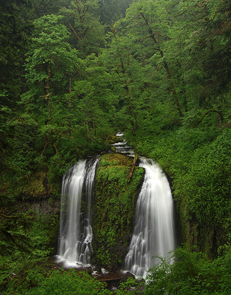
Lovely Upper McCord Creek Falls
To complete the second leg of the hike, retrace your route down to the “T” junction and continue straight (right) in a traverse across a mossy talus field. Soon, the trail abruptly drops into the lower McCord Creek canyon with another series of switchbacks. In this section, you’ll see old cable railings at an overgrown viewpoint that dates to the 1940s or 50s. You will also have a view down to the new McCord Creek Bridge on the HCRH State Trail, far below.
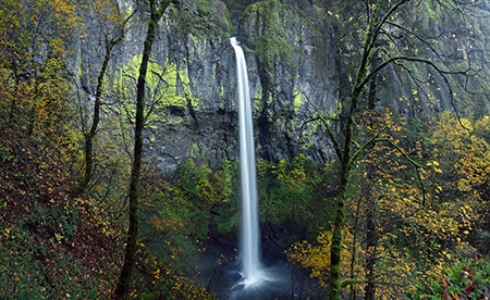
The lower trail soon traverses above noisy McCord Creek before arriving at the spectacular base of 213-foot Elowah Falls. The trail crosses the stream on a wooden footbridge here, and during the rainy season, expect to get wet — the spray is impressive!
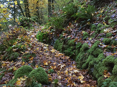
This pretty section of the original CCC trail is now bypassed, but fun to explore
You can do the fragile canyon ecosystem at Elowah Falls a favor in this area by not scrambling up the various boot paths that have formed here. Most are dead-ends left by hiking newbies that go nowhere, but are beginning to have an impact on the landscape.
Instead, there’s a better way to visit a lesser-visited viewpoint of the falls. Simply continue beyond the footbridge and begin traversing downstream along the canyon for about one-quarter mile. As the trail begins to curve away from the stream, watch for an obvious path on the right and above the main trail. This is a bypassed section of the original trail, and it’s in excellent shape for exploring.
You can follow the old tread past a couple of switchbacks, then to a fork, where a short spur leads left to a spectacular, boulder-top view of the Elowah Falls, framed by bigleaf maples. The main portion of the old tread continues a bit further, then dead-ends at another great view of the falls, where you can also see the modern trail and footbridge, below.
Elowah Falls from a viewpoint along the old trail section
If you do explore this abandoned section of trail, please stay on the tread — it’s obvious and easy to follow, with much of it still lined with CCC stone retaining walls. In recent years, boot paths to the viewpoints on the old trail have formed from the modern trail, below, so be sure not to reinforce these and simply retrace your steps along the old route to return to the main trail.
If you’re looking for a longer hike and more variety, you can also continue east from Elowah Falls for about a mile to the newly completed HCRH State Trail, where you’ll find a signpost marking the junction. Turn left on the wide, paved trail and follow it 1.2 miles back to the Yeon Trailhead, passing the impressive new McCord Creek Bridge along the way — another nice stop along the hike. This section of the new HCRH State Trail is noisy, as it follows the freeway closely, but it’s an interesting and new way to appreciate the Gorge from a different perspective.
How to Get There
From Portland, take I-84 to Ainsworth (Exit 35), a few miles east of Multnomah Falls and the eastern access to the drivable western section of the Historic Columbia River Highway. Turn left at the first intersection, then almost immediately turn right onto a frontage road where signs points to Warrendale. From here, continue east on the frontage road to the Yeon State Park trailhead, where the frontage road terminates at an eastbound freeway ramp. To return to Portland, follow the frontage road west to the Ainsworth interchange, and follow signs to Portland.
No trailhead permits are required here, and no restrooms or water are provided (note: water and restrooms are available just west of the Ainsworth interchange, at Ainsworth State Park). Dogs must be leashed in this state park! At least two dogs have had to be rescued by search and rescue teams in the Gorge after falling from cliffs this year because of careless owners who took exception to posted rules. Please set an example and respect this rule… and enjoy your trip!
______________
Special thanks to Scott Cook for his help on this article! Be sure to pick up a copy of Scott’s new guide to Portland: PDXccentric: the odyssey of Portland oddities! You can learn more on the PDXccentric Facebook page.

Pingback: 2015 Calendar… and looking back on 2014! | WyEast Blog