Muddy Fork Debris Flow at 20 Years

20 years later, it’s hard to imagine the massive debris flow that roared down the verdant Muddy Fork valley in 2002…

Earlier this year I posted a “then-and-now” look at the changes to the Cooper Spur area on Mount Hood’s east flank over the past 20 years, including dramatic changes to the Eliot Glacier. This article provides a similar look at forces of nature that have once again reshaped the Muddy Fork canyon, on Mount Hood’s steep western flank. 

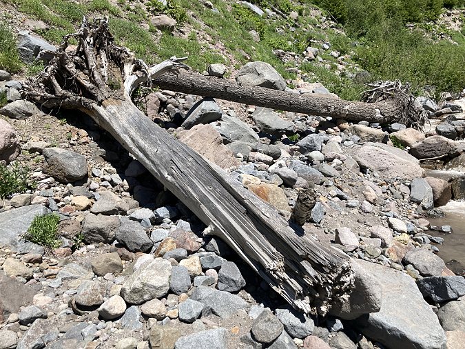
The story begins in the winter of 2002-03 with a massive debris flow triggered by a landslide in the upper Muddy Fork canyon. The event occurred sometime during the winter season, when deep snow-covered hiking trails, and thus went unnoticed until the snowpack cleared that spring. The event immensely powerful, mowing down whole forests and raising the valley floor of the upper Muddy Fork by as much as 20 feet. Whole trees were snapped off and carried downstream with the debris, forming huge piles that still give mute testimony to the power of the event.

Stacks of downed trees still give mute testimony to the violence of the 2002 event

Though the exact origins of the initial landslide remain unknown, the event was probably not triggered by a collapse within the Sandy Glacier that looms above the Muddy Fork, as there were few signs of the debris flow near the glacier, above the section of the upper canyon where the landslide scars were obvious. Instead, the debris flow likely began as a major slope collapse within the steep confines of upper canyon, where the Muddy Fork tumbles between sheer rock cliffs and steep talus slopes. 

The scars from the 2002 collapse are still plainly visible today (below), but the debris fields it created downstream are rapidly being reclaimed by new forests. The landslide created new cliffs and steep walls within the upper canyon, including new waterfalls along the Muddy Fork where the stream suddenly plunged over the newly exposed bedrock. 

The massive 2002 cliff collapse in the upper reaches of the Muddy Fork canyon gave birth to a debris flow that spread for miles downstream

Below the cliff-lined section of the upper canyon, the debris flow fanned out, spreading the landslide debris across the broad floor of the Muddy Fork valley. Nobody witnessed the event, so it’s unknown exactly how it played out. However, the wide debris fields of rock and sand clearly resulted from a major event, as did the complete removal of a standing forest. 

Trees swept up in the flow were stacked in piles that suggested a lot of water content in the debris flow – as much mud as it was rock – due to saturated winter soils and possibly a sudden snowmelt, perhaps from an unusually mild winter storm.  Whole trees were rafted on their sides until they were beached in giant log jams against forest stands along the valley margins that somehow survived. Evidence of the flow only became apparent when hikers returned that spring to find the Timberline Trail completely erased where it had crossed the Muddy Fork.

The raw cliffs and talus slopes surrounding McNeil Falls are still recovering from the event after 20 years

Over the course of the two decades that have since passed, the Muddy Fork quickly cut through the new debris to reach the old valley floor, revealing splintered stumps from trees that were snapped off during the event, then buried in the debris (below). This has confined the stream to a deep channel in the upper valley that limits its once-meandering ways across the valley floor, at least for now. However, the event only affected the north branch of the Muddy Fork, leaving the south branch almost untouched. 

Large trees by the thousands were snapped off and upended by the debris flow, then buried on the floor of the Muddy Fork valley

The Muddy Fork quickly excavated a new channel in the debris flow, unearthing trees like these that had been buried on their sides under the debris

While the north branch is currently confined to its newly cut channel, this is a temporary condition. Debris flows along Mount Hood’s glacial streams are a nearly constant reality, and even major events like the one that occurred on the Muddy Fork in 2002 are not uncommon. As jarring as these events are to witness, they also give us a privileged glimpse into the very processes that have shaped the mountain we know today. In time, smaller debris flows will gradually choke the current channel with debris, and the Muddy Fork will once again meander across the valley floor – just 20 feet higher than it was in 2002.

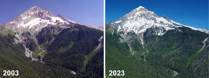
The Muddy Fork debris flow then… and now

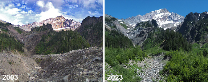
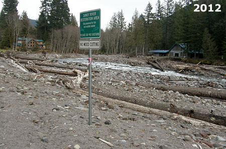
Though it wasn’t apparent to casual visitors from a distance, hikers who knew the mountain immediately spotted the debris flow from the open slopes of Bald Mountain, where the Timberline Trail provides a sweeping view of Mount Hood’s west face. Before the debris flow, the two main branches of the Muddy Fork had similar floodways at the head of the valley, below the Sandy Glacier. As the 2003 image (below, left) shows, the north branch was suddenly much wider. Today, forest recovery has nearly erased signs of the debris field (below, right) from this vantage point.

[click here for a large version of this photo pair]

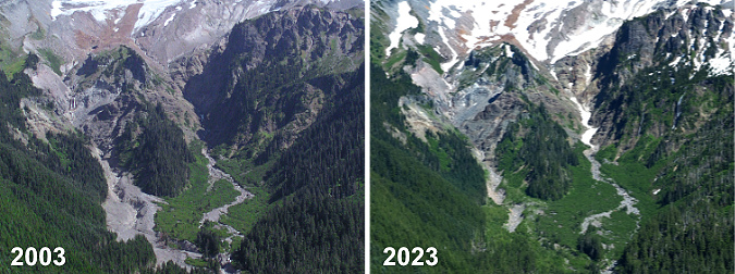
A closer look at this photo comparison reveals the scale of the debris flow in the summer of 2003, shortly after the event (below, left). The debris field was up to 1/4 mile wide and left up to 20 feet of debris in the channel of the north branch of the Muddy Fork. After 20 years (below, right), a carpet of green, recovering forest has already reclaimed much of the new debris field.

[click here for a large version of this photo pair]

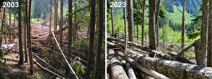
Down at ground zero, the scene at the head of the Muddy Fork valley in 2003 (below, left) was of astonishing destruction. Whole forests were toppled and piled like matchsticks along the margins of the debris flow, pushing into standing forests just high enough on the valley walls to have escaped the waves of debris. 

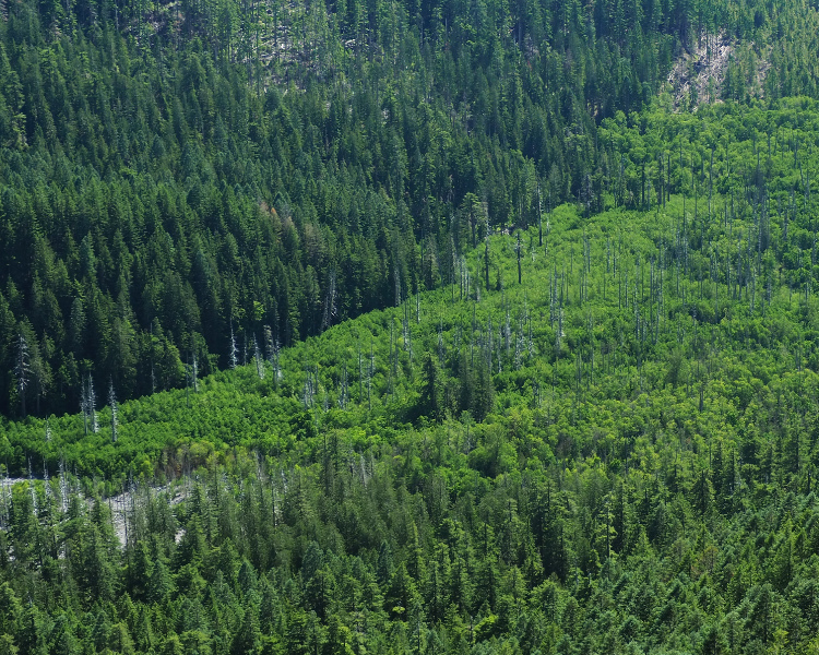
Twenty years later (below, right), most of the forest debris remains, though new logs were added to the jumble in the September 2020 wind event (described in this WyEast Blog article) that swept over Mount Hood. The new, mostly decidious forest rapidly emerging on the debris flow can also be seen in the 2023 image as the bright green band in the mid-background.

[click here for a large version of this photo pair]

The debris flow was still raw and unstable in the summer of 2003 (below, left), but after 20 years, a dense young forest (below, right) of Red Alder, Cottonwood and scattered Douglas Fir is quickly stabilizing the debris field. The health and vigor of this young forest growing on a 20-foot layer of boulders, gravel and sand is testament to the remarkable fertility of volcanic soils. While this new deposit contains almost new organic matter or true soil, the mineral content is rich in iron, potassium, phosphorus and other mineral nutrients essential to plant growth.  

[click here for a large version of this photo pair]

Red Alder and Cottonwood are no surprise, here. Both are pioneer species known for their ability to colonize disturbed areas – but the presence of Douglas Fir is a surprise (two can be seen in the foreground of the 2023 image). If the young firs growing within this largely deciduous new growth can keep pace with their broadleaf neighbors, the new forest could begin to be dominated with evergreen conifers within a few decades, speeding up the succession process that typically unfolds in a recovering forest.

Looking downstream (west) from the center of the debris field in 2003 (below, left) provided a true perspective on the scale of the event, with large debris deposits mounded against heaps of stacked, toppled trees. After 20 years, the recovery (below, right) is rapidly obscuring the view, though Bald Mountain can still be seen over the young tree tops. The tallest of the young trees in the 2023 view are Cottonwood and most of the smaller tree are Red Alder. The conifer in the foreground is a young Douglas Fir – roughly 15 tears old and about eight feet tall.

[click here for a large version of this photo pair]

Turning back (east) toward the mountain from roughly the same spot, the view in 2003 (below, left) revealed a new channel through the debris that the Muddy Fork had almost immediately begun excavating. By 2023 (below, right) the channel has been widened over the years, though its depth has since stabilized at the old valley floor level. The second photo also shows the new forest quickly hemming the channel in from both sides.

[click here for a large version of this photo pair]

Still, the Muddy Fork is a glacial stream, and therefore volatile. It continues to expand, then refill its new channel with debris from smaller flood events that occur almost every year.

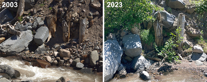
On one of my first visits to the debris field, I spotted a row of tree stumps (below) that marked the original valley floor – or perhaps an ancient valley floor? In this spot, the Muddy Fork had cut down through the loose flow material, exposing these sure markers of a former level of the valley floor. 

One surprise is how quickly the Muddy Fork settled in to its new landscape after the debris flow. As these photos show, the stream quickly cut its way to the former valley floor then mostly stopped cutting any deeper in the many years that followed, despite its famously volatile flow. These stumps – and even the two large boulders to the left – remain today much as they were 20 years ago, despite being directly adjacent to the stream and exposed to the many flood events that occur here.

[click here for a large version of this photo pair]

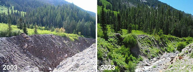
Looking downstream (below) from just above the spot where the stumps were revealed, you can see how little change to the new channel has occurred since it was initially carved in the year after the event. The large boulder on the lip of the channel (left side of these images) is still perched there – and the three Noble fir growing it that survived the original event are still thriving today, nearly twice as tall. 

[click here for a large version of this photo pair]

The most notable difference in the above photo pair is how debris has begun to refill the channel, as evidenced in the 2023 photo on the right. This process will continue over time until the channel has filled and the Muddy Fork is once again meandering across the main valley floor.

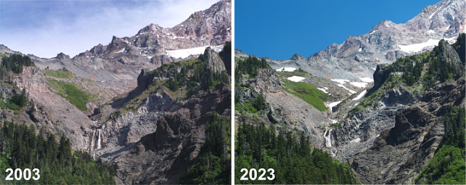
I don’t have good photo records of the narrow, upper canyon of the north branch Muddy Fork from prior to the 2002 debris flow. However, I have seen both photos (and even paintings) of this idyllic scene from the 1980s and 90s that show a waterfall here. Based on those earlier images, I do think that a single waterfall existed before the debris flow, roughly where the new falls is located today. Waterfall hunters have dubbed this “McNeil Falls”, referencing nearby McNeil Point – just off to the right in the photo pair, below.

[click here for a large version of this photo pair]

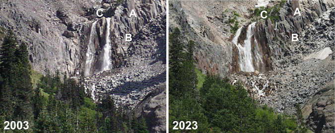
While the landslide and debris flow that it triggered in 2002 did seem to move McNeil Falls somewhat, the most notable change was to produce a twin waterfall – something waterfall hunters (the author included!) prize. However, as the reshaped falls has continued to evolve over the two decades since the event, the two segments have gradually begun to merge into one – or so I thought until I took a closer look for this article. 

In the following photo pair, you can see that the Muddy Fork has actually been carving away debris from the sloped bedrock, and simply moved the falls northward and down the cliff scarp. You can see the shift by matching the rocks marked “A” on the right, the dark notch to the left of the letter “B” and the protruding rock marked “C” that – surprisingly – used to divide the two tiers of the falls! Today, the south (right) tier of the semi-twin drop is really the original north tier, and a completely new tier has formed to the left of this original tier where landslide debris was cleared from the rock ledge. 

[click here for a large version of this photo pair]

Look closely at the above photo pair and you can also see some very large boulders perched to the left of the falls as they existed in 2003. These have since been eroded away, and contributed to the pile of rock debris that has accumulated at the base of the falls in the 2023 photo –shortening the falls a bit.

What will the future bring for McNeil Falls? My guess is that it will continue to shift north a bit more, likely becoming a single tier – twin waterfalls are rare! But even as it find its way to a lower brink along that cliff scarp, the stream will also gradually move loose rock away from the base of the falls as the canyon walls stabilize, so it might become taller over time. There are other examples of exactly this phenomenon on other big waterfalls around Mount Hood – most notably, Stranahan Falls, on the Eliot Branch, which has gained at least 30 feet in height from an eroding canyon floor at its base. Of course, McNeil Falls will also continue to suffer the brunt of the Muddy Fork’s volatile nature and keep changing and reinventing for centuries (and millennia) to come.

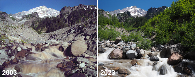
Downstream from the falls, the bed of the Muddy Fork continues to gradually collect new debris as the channel carved in the years immediately after the debris flow continues to fill. This can be seen in the photo pair (below), where large boulders now fill the floor of the new channel – and even support young alder and willow pioneers on small midstream islands.

[click here for a large version of this photo pair]

The downstream effects of the 2002 debris flow on the Muddy Fork were less dramatic, yet still reshaped the way the river flows through its valley. This view of the valley (below) from Bald Mountain is roughly two miles below the source of the debris flow. The large rock and gravel deposits along the stream are still plainly visible twenty years later, though the bright green alder and willow colonies have begun to reforest the flooded area. In this view, you can also see the bleached ghost trees along both sides of the stream that were killed by the debris flow. 

Though riparian trees like Sitka alder and willows are making inroads, the Muddy Fork continues to meander across the debris flow where the valley is less steep and the stream less channeled

These disturbed areas now serve as important habitat for raptors and cavity-nesting birds alike, along with many other species that require standing skeleton trees to survive. The dense new riparian growth (below) is equally important to many species that require streamside habitat. While major events like the 2002 debris flow might be shocking for us, it’s also a reminder that violent processes like this are built into the cycle of the ecosystem – they are required for the species who have adapted over millennia to forests that continually cycle through disruption and recovery. 

Large areas of the debris flow have recovered further downstream from the event, marked by the bright green stands of alder, willow and cottonwood along the Muddy Fork in this view from Bald Mountain

Debris flow pioneers

Whether from fire, debris flow or even human-caused events like logging, watching our forests recover and rebuild provides invaluable insight into the role individual species play in the health of forests. Where we used to value our forests mostly for the lumber that could be harvested (and therefore, mostly for big conifers) we now know that non-commercial species like alder, willow and cottonwood are as essential to forest health as the conifers.

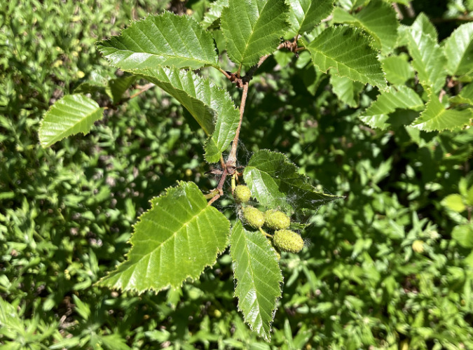
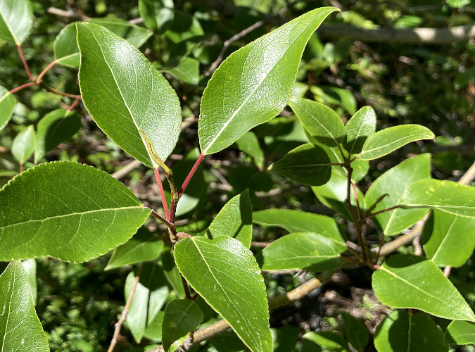
Twenty years into the recovery, I expected to find Sitka alder (below) dominating the young forests returning to the debris flow, as these tough, adaptable trees among the first to reclaim disturbed ground wherever it might occur. They are often called “slide alder” for their ability to survive in avalanche chutes, as they freely bend and give under the heaviest of winter snow loads, often popping new leads from horizontal, snowpack-flattened limbs. But alders have a super-power that is especially important in forest recovery: they are nitrogen fixers that enrich the soil as they grow, making them uniquely suited as pioneers in disturbed areas.

Sitka alder growing on the Muddy Fork debris flow

What I didn’t expect to find in the recovering forest atop the debris flow were Black cottonwood (below). Yet, many are thriving throughout the alder thickets, outpacing the alders since they can easily grow to 50-60 feet in mountain environments compared to just 30-40 feet for alders. Cottonwood are fast growers, too, especially where they can tap into a steady supply of groundwater – something the shallow water table in the Muddy Fork valley provides in abundance. They are important wildlife trees, too, including the browse they provide as young trees and the nesting cavities that form in the trunks of older trees as they mature.

Cottonwood growing on the Muddy Fork debris flow

An even more startling pioneer in the recovering forest on the debris flow are Douglas fir (below). These trees don’t require much of an introduction — as our state tree and a species found all over Oregon. I didn’t expect to find so many here, in part because we’ve been conditioned by the timber industry to believe these native conifers must be hand-planted after logging, and then only after all other vegetation that might compete has been killed with herbicides.  

Douglas fir growing on the Muddy Fork debris flow

Douglas fir are fast growers, and with their early arrival as pioneers in the new forests along the Muddy Fork, there’s a good chance they will keep pace with both the alders and cottonwood and quickly begin to restore a conifer overstory – though “quick” is measured in decades and centuries when describing forest recovery! 

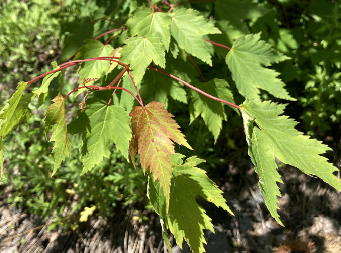
Douglas maple growing on the Muddy Fork debris flow

Another surprise in the new forest growing on the debris flow is Douglas maple (above), a close cousin to our Vine maple, and sometimes called Rocky Mountain maple. These attractive trees are sprinkled throughout the young trees returning to the Muddy Fork and they are positioned to become part of the future understory of a mature conifer stand. Where alder and cottonwood are eventually shaded out by taller conifers, Douglas maple are more tolerant of shade, and can coexist with the big trees. They are also more drought-tolerant than their Vine maple cousins, and thus well-suited to the sandy upper layers of the debris flow that can become quite dry during summer droughts.

The cycle continues… except faster, now

Just as the recent series of wildfires in WyEast country have given us the gift of insight into how a forest regenerates after a burn, the debris flow on the Muddy Fork is providing a glimpse into the resilience of Mount Hood’s forests in the face of growing disturbances from climate-driven floods, landslides and debris flows. There is no way to know if the 2002 landslide in the Muddy Fork canyon was triggered by climate change, yet scientists do know that extreme rain events and unusually saturated soils are increasingly triggering such events. And while these events have always occurred, the extreme and often erratic nature of our storms in recent years has accelerated the pace and scale of flooding and debris-flow events on the mountain. The good news from the Muddy Fork is that our forests are – so far – coping well with these changes, especially in riparian areas where the restored habitat is most critical. 

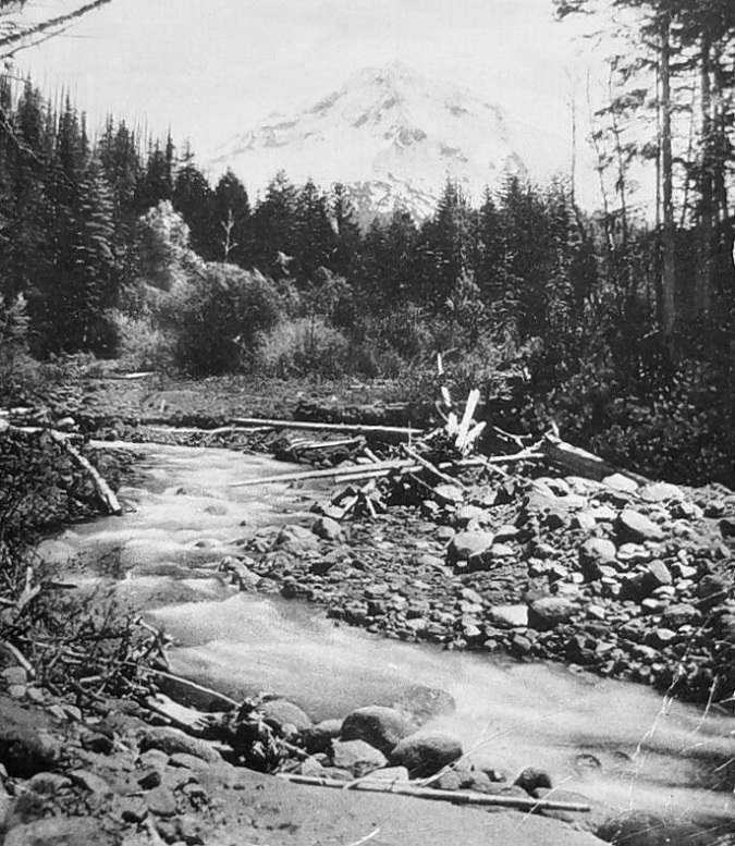
Early 1900s scene along the upper Sandy River

Historic images and geologic evidence show these events to be part of a timeless cycle of destruction and rebirth. This image (above) show the upper Sandy River valley in the early 1900s, with mix of debris and young streamside vegetation (the willows and alders toward the background) that look much like today’s conditions. Clearly, periodic floods and debris flow events had always played a role, here.

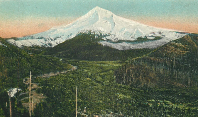
This image (below) is a wider, hand-tinted view from about 1900 that shows the Muddy Fork branch of the Sandy River hugging the left side of the valley, with obvious signs of flooding and debris flows. There’s a story in the young forests covering the balance of the flat Sandy River valley floor, too (known as Old Maid Flat) in this view: at the time the photo was taken, just over a century had elapsed since the Old Maid eruptions on Mount Hood covered this entire valley with a debris flow that extended 50 miles downstream to the Columbia River, creating today’s Sandy River Delta. This very early view also shows burn scars (colorized as white snow) around the western foot of the mountain that have long-since recovered, and are now covered with dense forests of Noble fir.

The Muddy Fork is the open channel on the left in this colorized view of the Sandy River Valley from about 1900

While these events may seem random and jarring in from the perspective of a human lifetime, when you connect the dots between events over geologic time, the continuum is that of a mountain in a perpetual state of both eroding and occasionally rebuilding itself, one catastrophic event after another.

It is this long view that helps us understand and appreciate how our forests have evolved not to a specific end-state (the view from a logging perspective), but instead, have evolved to continually adapt to their conditions in a perpetual state of renewal and rebirth. The fact that our forests are rebounding so readily in places like the Muddy Fork or the scorched slopes of the Gorge fire — even now, in the midst of climate change – is both inspiring and reassuring in a time of unprecedented change in the world around us.

A Tale of Two Ranger Stations: Part Two

Forest Service guard on duty at the Upper Sandy station in the 1930s

Forest Service guard on duty at the Upper Sandy station in the 1930s

Mount Hood National Forest (MHNF) recently completed a $1.7 million overhaul of its Zigzag Ranger Station, the de-facto visitor gateway to Mount Hood. Yet the historic Upper Sandy Guard Station, a National Historic Landmark located just a few miles away, near popular Ramona Falls, has fallen into a serious state of disrepair.

Basic repairs needed to save the historic guard station would cost a fraction of what the Zigzag project cost, so why has the Upper Sandy structure been so badly neglected? Part two of this article looks at some of the reasons behind this frustrating paradox, and some possible solutions.

1930s: Guarding Portland’s Watershed

The Upper Sandy Guard Station was built along the newly constructed Timberline Trail in the 1930s. Its purpose was to house a Forest Service guard, stationed there to patrol the Bull Run Reserve — Portland’s water supply — where it abutted the new around-the-mountain recreation trail. At the time, the Bull Run boundary was much more expansive, touching the northwest corner of Mount Hood.

Guard stations were important landmarks for early forest travelers

Guard stations were important landmarks for early forest travelers

The Upper Sandy Guard Station was one of dozens dotting the Mount Hood National Forest in the 1930s, all built to protect forest resources from timber poaching and other illegal activities. Several of the old guard stations could only be reached by trail, and the roads that did reach them were primitive.

The guard stations also served as a supply and communications base for the scores of fire lookouts built throughout the forest, often connected by phone lines that can still be found along less-traveled trails today. As recreation use along forest trails grew in the 1920s and 30s, guard stations also provided a comforting presence for hikers exploring the largely undeveloped national forests of the time.

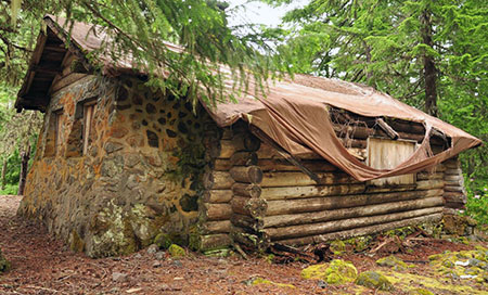
Today the Upper Sandy Guard Station is slowly fading away (Cheryl Hill © 2013)

Today the Upper Sandy Guard Station is slowly fading away (Cheryl Hill © 2013)

View of the handsome stonework that makes the guard station unique  (Cheryl Hill © 2013)

View of the handsome stonework that makes the guard station unique (Cheryl Hill © 2013)

The industrial logging era that began in the national forests by the late 1940s soon made guard stations obsolete: as thousands of miles of logging roads were bulldozed into remote areas once only accessible by trail, forest administrative operations were consolidated into a few ranger district office, and most of the old guard stations were shuttered.

The unused buildings soon fell into disrepair, and most of these structures were dismantled or burned by the Forest Service in the late 1950s and 1960s (along with most fire lookouts, also deemed obsolete as aerial fire surveillance began).

When the Bull Run Division boundary was changed in 1977, the Upper Sandy Guard Station was left miles away from the resource it was built to defend. One year later, the Mount Hood Wilderness was expanded to encompass the building, sealing its fate as a relic in the eyes of the Forest Service.

In recent years the roof on the Upper Sandy Guard Station has partially collapsed, despite crude repairs by volunteers  (Cheryl Hill © 2013)

In recent years the roof on the Upper Sandy Guard Station has partially collapsed, despite crude repairs by volunteers (Cheryl Hill © 2013)

The few guard stations that did survive decades of neglect intact now represent a precious glimpse into an earlier, idyllic time in the national forests. They now stand as historical gems, worthy of special protection.

Some of these structures have already been preserved, like the Clackamas Lake Guard Station near Timothy Lake, while others have been allowed to fade away nearly to oblivion, like the Upper Sandy Guard Station. A few that survived intentional destruction by the Forest Service have nonetheless been lost to neglect, like the former High Prairie Guard Station on Lookout Mountain, a building that was partially standing as recently as the early 1980s.

Ruins of the High Prairie Guard Station in 1983 before it faded into the meadow

Ruins of the High Prairie Guard Station in 1983 before it faded into the meadow

In September 2009, the National Park Service finally added the Upper Sandy Guard Station to the U.S. National Register of Historic Places, a move that many considered to be the building’s salvation. After all, the Forest Service had actively sought the historic designation and local Forest Service historians had strongly advocated for preservation of the building. Thus, the disappointment in the years since, as even the most rudimentary Forest Service efforts to stabilize the building failed to materialize.

Instead, the Forest Service posted the following notice on the building, “warning” hikers that entering the structure presented a dire hantavirus risk from resident deer mice. The notice actually admits that only one (!) documented hantavirus case has ever been documented in Oregon, and that “there is no evidence that the disease is carried by rodents who call this building home.”

Of course, deer mice surely inhabit every other historic wilderness structure in the wilderness areas around Mount Hood, yet no health warnings are posted on the shelters at McNeil Point, Cairn Basin, Cooper Spur and Elk Meadows or the lookout at Devils Peak, where hikers routinely camp inside (and maintain) the structures. So, the point of this notice on the Upper Sandy structure seems to be to frighten visitors from entering — or perhaps maintaining — the structure.

The Forest Service has posted this "health warning" on the structure to discourage visitors  (Cheryl Hill © 2013)

The Forest Service has posted this “health warning” on the structure to discourage visitors (Cheryl Hill © 2013)

The Upper Sandy Guard Station was added to the elite National Register partly because of its historic role as a base for patrolling the Bull Run Reserve, but mostly as the only surviving design of its kind in the Pacific Northwest. The building has a unique, rustic architecture that embodies the New Deal programs that put skilled craftsmen and laborers to work on our public lands as part of the 1930s economic recovery.

Most notable is the massive stone masonry end wall that has probably helped stabilize the structure as the log walls continue to deteriorate. Its unique design combining rubble stone and wood walls make it one of a kind among the more than 700 forest administrative buildings constructed during the New Deal era.

The building was constructed by a seven-man crew in the summer of 1935 with a budget of $958.88, including materials: two carpenters worked at the rate of $7/day and two laborers assisted at the more modest rate of $4/day. The guard station was completed on September 28, 1935.

Today the building suffers serious holes roof and will almost certainly be lost in a few years without an immediate effort to stabilize the structure, or better yet, all of the work needed to fully restore this building. So, why is the Forest Service allowing this to happen? Blame it on the Wilderness..?

Does the Upper Sandy Guard Station have a future? (Cheryl Hill © 2013)

Does the Upper Sandy Guard Station have a future? (Cheryl Hill © 2013)

For a time following the 2009 National Historic Register listing, the old guard station had an advocate in the Northwest Forest Conservancy (NFC), a local non-profit focused on preserving several historic forest structures in the Mount Hood National Forest. Today, the NFC appears to be inactive, and there are no advocates pressing for the building to be rescued.

Prior to the 2009 Historic Register listing, the NFC formally proposed managing a restored building. Today, several historic structures in the Tilly Jane area (on the northeast side of Mount Hood) are managed in this way by the Oregon Nordic Club under an agreement with the Forest Service.

Under such an arrangement, the Upper Sandy Guard Station could have been put it to year-round use as part of its restoration. The NFC envisioned volunteers to staff the guard station during the summer, as the proximity to both the trailhead and nearby Ramona Falls makes the guard station a natural base for both volunteers and visitors. Sadly, this plan never moved forward.

The Upper Sandy Guard Station was prominent on this 1939 map of the Timberline Trail, along with the log shelter that once stood at Ramona Falls

The Upper Sandy Guard Station was prominent on this 1939 map of the Timberline Trail

Despite the agency effort to list the building on the National Register, friends of the old guard station within the Forest Service are surprisingly scarce, and mostly limited to historic resource specialists whose workloads spans multiple forests.

Unfortunately, the Upper Sandy Guard Station carries a still heavier burden than simply a lack of interest from the Forest Service: since a 1978 expansion, the guard station has located within the Mount Hood Wilderness, which by some interpretations means it should be allowed to fade into the oblivion in deference to protecting the untrammeled nature of wilderness.

Is it really that simple? Not at all, but internal Forest Service e-mails on the fate of the historic structure show Mount Hood National Forest recreation planners quickly turning to this argument in defending the decision to let the Upper Sandy Guard Station fall further into disrepair. The same e-mail exchanges also reveal internal rivalries between recreation and historic resource staff that have more to do with protecting recreation budgets than adhering to strict interpretations of the Wilderness Act.

Letting this historic building deteriorate is also at odds with the 1999 Mount Hood National Forest facilities master plan, a forest-wide effort to address surplus Forest Service building. The facilities master plan identified the Upper Sandy Guard Station as surplus building, but set no policy for decommissioning or disposing of the structure — one of the core purposes of the facilities plan.

The Devils Peak lookout has apparently found favor with the Forest Service, despite its location inside the Salmon-Huckleberry Wilderness

The Devils Peak lookout has apparently found favor with the Forest Service, despite its location inside the Salmon-Huckleberry Wilderness

The 1999 facilities plan includes other historic structures located inside wilderness area, notably the lookouts at Bull of the Woods and nearby Devils Peak. Both lookouts are included in the National Historic Lookout Register, which is often a first step toward listing in the more rigorous National Historic Landmark Register.

While the Forest Service is silent on Bull of the Woods lookout (and the structure is now showing signs of serious disrepair) the Devils Peak Lookout is described on the Mount Hood National Forest website “open to the public” and maintained as a Forest Service facility.

Why the disparity, especially given that the Devils Peak lookout lacks National Historic Register status? For now, that remains a mystery, as the Forest Service does not seem to have a comprehensive plan for their historic wilderness structures, nor a consistent policy on which structures will be allowed to deteriorate beyond the point of repair — including the remaining Timberline Trail shelters and other facilities across the forest that have gradually been incorporated into new wilderness areas over the years.

This massive new bridge over modest Ramona Creek was built in 2012 inside the Mount Hood Wilderness, less than a mile from the Upper Sandy Guard Station.

This massive new bridge over modest Ramona Creek was built in 2012 inside the Mount Hood Wilderness, less than a mile from the Upper Sandy Guard Station.

Still more confounding is the fact that the Forest Service constructed an elaborate new bridge over Ramona Creek in 2012, just a mile from the Upper Sandy Guard Station and well within the Mount Hood Wilderness. Ramona Creek is a modest stream that can be easily crossed without a bridge, so how was this structure justified?

In a reportedly confrontational exchange in 2007 over the Upper Sandy Guard Station several years ago, a recreation planner from the Zigzag Ranger District responded to questions about the structure with “Have you READ the Wilderness Act? Man-made structures are NOT allowed!” Yet, the same planner was apparently responsible for construction of the elaborate new wilderness bridge over Ramona Creek in 2012.

Clearly, the Mount Hood National Forest has no consistent policy on structures in wilderness areas, historic or otherwise, and thus the highly selective, subjective decisions by district-level staff to build new structures while allowing historic structures to deteriorate.

So, what to do? Fortunately, the answer seems to be coming from the federal land agencies, themselves.

Rethinking the Wilderness Act

Core to the Mount Hood National Forest rationale for letting the Upper Sandy Guard Station fade into oblivion is the opinion — albeit, selectively applied — that “man made structures are not allowed” in wilderness areas. This opinion stems from a series of three recent court decisions and is now widely shared as gospel among the federal land rank-and-file staff.

The stone Cooper Spur shelter along the Timberline Trail is among the historic gems that depend on a better interpretation of the Wilderness Act to survive for future generations

The stone Cooper Spur shelter along the Timberline Trail is among the historic gems that depend on a better interpretation of the Wilderness Act to survive for future generations

However, there is an emerging opinion among wilderness experts within the federal agencies that maintaining and restoring historic wilderness structures is consistent with the 1964 Wilderness Act, and that recent court decisions are more a reflection of flawed arguments made by the federal government in defending its actions to protect historic (and other) structures in wilderness areas. This new argument starts with a key passage in the Wilderness Act, which is the basis for the recent court decisions:

Except in certain specific instances, “there shall be no…structure or installation within any [wilderness] area.” (Wilderness Act, Section 4(c))

In their defense, the federal government has pointed to another passage in the Wilderness Act, arguing that the maintenance or restoration of historic structures qualifies as “use” and is clearly called out among the public purposes of the act:

“Except as otherwise provided in this Act, wilderness areas shall be devoted to the public purposes of recreational, scenic, scientific, educational, conservation, and historical use.” (Wilderness Act, Section 4(b))

Yet, in recent decisions the courts have focused upon the “except as otherwise provided” preface to this clause, and in three key decisions have interpreted historic structures to be at odds with the Wilderness Act. The new thinking emerging among federal wilderness experts focuses on a different defense that would build on this passage in the Wilderness Act:

“A wilderness…may also contain ecological, geological, or other features of scientific, educational, scenic, or historical value.” (Wilderness Act, Section 2(c))

Under this argument, a new approach to defending protection of historic resources in wilderness areas would focus on the “value” of the resource, not “use”, and therefore the mere existence of a demonstrably historic resource like the Upper Sandy Guard Station would be enough to justify maintenance (and even restoration) over time. Finally, another section of the Wilderness Act fills out this new approach, where the act states that structures are generally prohibited except:

“…as necessary to meet minimum requirements for the administration of the area for the purpose of this Act.” (Wilderness Act, Section 4(c))

Therefore, if historic structures represent a “feature of value”, then preserving the structure would be the “minimum requirement” for administering the resource. That’s a lot of legal wrangling, but it could just be what saves our historic wilderness structures.

The Upper Sandy Guard Station sits on a flat bench above the Sandy River, just off the modern alignment of the Pacific Crest Trail.

The Upper Sandy Guard Station sits on a flat bench above the Sandy River, just off the modern alignment of the Pacific Crest Trail.

Taking this interpretation a step further, the fact that “scientific, educational (and) scenic” values are also listed suggests that preserving the Upper Sandy Guard Station by virtue of using it as an overnight rental facility or even staffing it to provide an administrative presence along the overwhelmingly popular Ramona Falls Trail would also be “values” that pass muster under the Wilderness Act. So far, this new approach has not been tested in the courts, but it does offer a hopeful alternative to the troubling direction of recent decisions.

The historic Green Mountain Lookout near Glacier Peak, saved from the federal courts in 2014 by an Act of Congress

The historic Green Mountain Lookout near Glacier Peak, saved from the federal courts in 2014 by an Act of Congress

In the meantime, historic resource advocates in the State of Washington recently short-circuited these recent court decisions in a successful effort to save the Green Mountain Lookout, located inside the Glacier Peak Wilderness.

The Forest Service was taken to court in 2010 over a major restoration of the historic lookout needed to save the structure after years of neglect, including the use of helicopters to carry materials to the remote lookout site. In 2012, the case resulted in one of the three court rulings that have since become the mantra against protecting wilderness structures, and the Forest Service began preparing to remove the building under court order.

Historic resource advocates in Washington State were stunned, and took the case to their congressional delegation. Under the leadership of Senators Patty Murray and Maria Cantwell, Congress acted to permanently protect the structure in April of this year, paving the way for the Forest Service to continue to maintain the Green Mountain lookout for the enjoyment of the public indefinitely.

Saving it by using it?

Ramona Falls is among the most visited wilderness destinations in the country and could use a better ranger presence - why not use the Upper Sandy Guard Station as a base?

Ramona Falls is among the most visited wilderness destinations in the country and could use a better ranger presence – why not use the Upper Sandy Guard Station as a base?

So, how can the Upper Sandy Guard Station be saved? Above all, the building needs an energetic advocate in the form of a non-profit dedicated to historic preservation our public lands – or perhaps even a “Friends of the Upper Sandy Guard Station” non-profit.

The fact that the Mount Hood National Forest has been so arbitrary in its decisions to maintain or build some wilderness structures while allowing others to fall into disrepair is an opportunity: consistent, persistent pressure should be enough to get the Forest Service to do the right thing, and save this priceless old building.

Another possibility is an act of Congress, mirroring the Green Mountain precedent. Given the dire state of the building, perhaps Oregon Senators Ron Wyden and Jeff Merkley could follow in the footsteps of Washington Senator Murray and Cantwell, and simply direct the Forest Service (and the courts) to preserve and restore the building?

These original windows on the guard station were intact as recently as 2008

These original windows on the guard station were intact as recently as 2008

But even with needed repairs, the Upper Sandy Guard Station still lacks a sustaining purpose beyond its intrinsic value as a historic structure. Clearly, the Forest Service sees little value in the building, but to hikers, the structure could be invaluable if managed as a recreation resource.

Here’s how: in summer the guard station could operate in its intended function, with volunteer rangers living in the building during the period when the Sandy River trail bridge is installed (late May through September).

This would put a needed presence on a trail that is heavily traveled, and unfortunately has problems with car break-ins and rowdy visitors at Ramona Falls. The building has the potential to be quite comfortable, as it was originally served with a piped water supply (since removed), and had a sink, small kitchen and even a shower stall that still survives.

Original brass window hardware was still present in 2008, but has since been stripped from by building by vandals

Original brass window hardware was still present in 2008, but has since been stripped from by building by vandals

Volunteer seasonal rangers could also serve as interpreters, giving tours of the old structure and answering questions at Ramona Falls, where the overwhelming share of visitors are casual hikers and young families new to the forest.

Once the seasonal trail bridges have been removed in fall, the guard station could transition to a winter rental, much as several lookouts in the area and the historic guard station at Tilly Jane are operated today. The Old Maid Flat area is a popular snowshoeing and Nordic skiing area, and a restored guard station would be an idyllic overnight destination in high demand. Revenue from rentals could also help pay for needed maintenance and repairs to the structure.

This magnificent fireplace stands at the center of the guard station; the room in the background is a built-in shower, lined with galvanized steel.

This magnificent fireplace stands at the center of the guard station; the room in the background is a built-in shower, lined with galvanized steel.

Could this really work? There are some logistical consideration that would have to be bridged by the Forest Service to actually bring the building back into public use, but they are not insurmountable. First, regular use of the structure would require an outhouse to be restored to the site. Hopefully the original location could be determined from old photos or building plans.

Second, the building would need to be supplied with firewood for winter use, which in turn, would require a woodshed. The National Historic Register evaluation of the building describes a shed that was apparently dismantled many years ago, but could be faithfully restored as part of reconstructing the guard station as it was originally built.

Today, the main structural risk to the building is where several holes have formed in the roof around the chimney. The tarps visible in this photo were placed by the National Historic Register survey crew in 2008 to help stabilize the building.

Today, the main structural risk to the building is where several holes have formed in the roof around the chimney. The tarps visible in this photo were placed by the National Historic Register survey crew in 2008 to help stabilize the building.

Supplying the Guard Station with firewood would be another matter, as any firewood would need to be collected without the use of power tools — a routine task for the hardy individuals who built these structures, but more daunting to us in the modern era. This could be one of the activities of the summer resident rangers. Bundles firewood could also be dropped at the site when a helicopter is already being used to pull out the Sandy River hiking bridge at the end of the summer season.

What next?

Hopefully, this beautiful old structure will find a champion soon, as time is running out for the Upper Sandy Guard Station. While the building condition was described as “excellent” as recently as the 1980s, it has begun to experience major problems from neglect. Worse, vandals have since stripped the building of furnishings and even burned the original wood shutters. The Upper Sandy Guard Station deserves better!

If you would like to help out, consider sending a message to the Forest Service or even your congressional representatives expressing your support for saving this one-of-a-kind window into the past before it’s too late:

Contact Mount Hood National Forest Contact Senator Ron Wyden Contact Senator Jeff Merkley Contact Rep. Earl Blumenauer

If you would like to see the building for yourself, it’s easy to find. The building is on a bench above the Sandy River floodplain, just a few hundred feet off the trail where the Ramona Falls loop intersects the Pacific Crest Trail, near Ramona Falls. The best time to visit is during the summer, when the Sandy River hikers bridge has been installed for the season.

Sandy Glacier Caves: Realm of the Snow Dragon

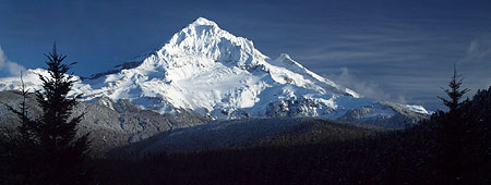
The Sandy Glacier is front and center in the classic view of Mount Hood from Lolo Pass

The Sandy Glacier is front and center in the classic view of Mount Hood from Lolo Pass

Oregon Public Broadcasting’s venerable Oregon Field Guide series kicks off it’s 25th season in October with a remarkable story on the hidden network of glacier caves that have formed under the Sandy Glacier, high on Mount Hood’s west flank.

In the video preview (below), Oregon Field Guide executive producer Steve Amen says that “in the 25 years we’ve been doing Oregon Field Guide, this is the biggest geologic story that we have ever done”. This is bold statement from a program that has confronted all manner of danger in documenting Oregon’s secret places!

Glacier caves are formed by melt water seeping through glaciers and flowing along the bedrock beneath glaciers. Over time, intricate networks of braided tunnels can form. Because a glacier is, by definition, a river of moving ice, exploring a glacier cave is inherently dangerous — and this is what makes the upcoming Oregon Field Guide special so ambitious.

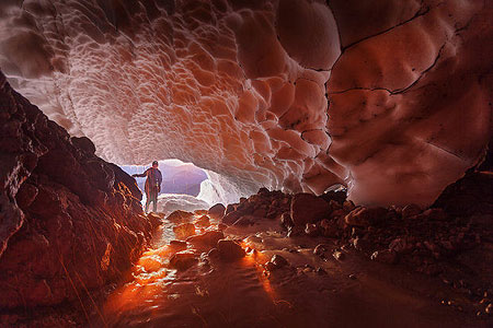
Otherworldly scene from Oregon Field Guide's upcoming "Glacier Caves" special (Brent McGregor/OPB)

Otherworldly scene from Oregon Field Guide’s upcoming “Glacier Caves” special (Brent McGregor/OPB)

Cave explorers have been actively exploring and mapping the extent of the Sandy Glacier caves for the past three years. This previously unknown network of caves has been dubbed the Snow Dragon Glacier Cave System by cavers Eduardo Cartaya, Scott Linn and Brent McGregor in July 2011. Cavers have since surveyed (to date) well over a mile of caves in the network, with parts of the cave system nearly 1,000 feet deep.

Ice Cave or Glacier Cave? Here in volcano country, it’s worth noting that a glacier cave is different than an ice cave. Where a glacier cave has roof of glacial ice, an ice cave occurs where persistent ice forms inside an underground, rock cave. In the Pacific Northwest, we have several examples where ice has accumulated inside lava tubes to form true ice caves, such as the Guler Ice Cave near Mount Adams and Sawyer’s Ice Cave in Central Oregon.

To date, the Snow Dragon cave network consists of three caves that intersect, dubbed the Snow Dragon, Frozen Minotaur, and Pure Imagination caves. Within these caves explorers have discovered a fantastic landscape of streams and waterfalls flowing under a massive, sculpted ceiling of ice.

The caves are punctuated by moulins (pronounced “MOO-lawn”), or vertical shafts in the ice formed by meltwater. Some of these moulins are dry, some are still flowing, and a few have have grown to become skylights large enough serve as entry points into the cave system for daring explorers.

Caving expeditions to the Sandy Glacier caves by the National Speleological Society (NSS) in 2011 and 2012 were featured in the February 2013 NSS News, with a dramatic photo of colossal moulin on its cover. These volunteer expeditions included NSS geologists, glaciologists, spelunkers, scuba divers and mountain climbers who spent eight days documenting the cave system from a base camp high atop the Sandy Glacier.

Sandy Glacier caves on the cover of the National Speleological Society News earlier this year

Sandy Glacier caves on the cover of the National Speleological Society News earlier this year

According to the NSS explorers, the Snow Dragon cave complex is the largest ice cave complex in the lower forty-eight states, and one of the largest in the world. To date, these explorers have found icy passages ranging from huge, ballroom-sized open spaces with 40-foot ceilings to narrow, flooded crawl sapces only a few feet high, and passable only with diving gear.

The Oregon High Desert Grotto, an affiliate of the NSS, has posted a series of fascinating maps documenting their explorations on their website.

The Story Behind the Sandy Glacier Caves?

Glacier caves typically form near the snout of a glacier, and explorers simply follow the outflow stream into the cave system. Such was the case with Paradise Ice Caves at Mount Rainier (now disappeared) at the terminus of the Paradise Glacier. More recently, hikers have explored the outflow opening at the Sandy Glacier, as well.

Topographic map of Mount Hood's west flank and the Sandy Glacier

Topographic map of Mount Hood’s west flank and the Sandy Glacier

[click for a larger map]

The Snow Dragon caves under the Sandy Glacier are different, however. While the glacier does have an outflow opening to the cave system, the cave network extends far beyond the terminus of the glacier, apparently reaching almost to the headwall, nearly a mile away and almost 2,500 feet above the terminus in elevation. The scale and scope of these caves seems to be partly the result of the glacier shrinking, and not just the effects of melting near the terminus of the glacier.

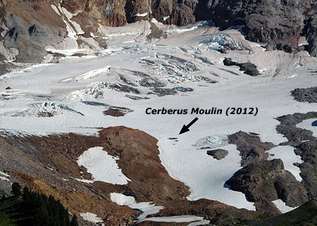
This broader phenomenon first became apparent when a huge moulin — known informally to many hikers as the “glory hole” and formally named the Cerberus Moulin by cavers — appeared in the glacier a few years ago. The Cerberus Moulin is plainly visible to hikers from nearby McNeil Point, which also serves as the jump-off point for explorers.

The Cerberus Moulin is located along the lower, receding edge of the Sandy Glacier

The Cerberus Moulin is located along the lower, receding edge of the Sandy Glacier

A closer view of the Cerberus Moulin in the Sandy Glacier

A closer view of the Cerberus Moulin in the Sandy Glacier

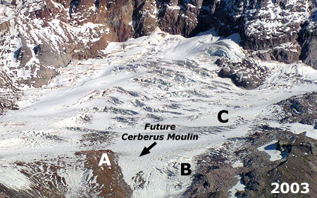
The following photos of the Sandy Glacier were taken nine years apart, in 2003 and 2012, and show the startling retreat of the glacier over just the past decade. The Cerberus Moulin had not yet formed in the 2003 photo, but is plainly visible in the 2012 image. For reference, the broad moraine to the left of the Cerberus Moulin is labeled as (A) in the photos:

Sandy Glacier in 2003

Sandy Glacier in 2003

Sandy Glacier in 2012

Sandy Glacier in 2012

The photo comparison shows big changes in the activity of the glacier, too. What was once an icefall near the terminus of the glacier (B) in 2003 has since receded to the point that the rock outcrop that was beneath (and formed) the icefall is now exposed in the 2012 image. Likewise, the lower third of the glacier (C) was clearly crevassed and actively moving in the 2003 image compared to the 2012 image, where an absence of crevasses shows little glacial movement occurring today in this section of the glacier.

The rapidly shrinking glacier could be an explanation for the relative stability and remarkable extent of the caves underneath the ice. The increased melting is sending more runoff through and under the glacier, helping to form new moulins feeding into the ice caves.

The slowing movement of the lower portion of the glacier could also help explain why the cave network has become so extensive, as more actively flowing ice would be more likely to destroy fragile ice caves before they could become so extensive and interconnected.

Part of a Larger Story

The Sandy Glacier Caves discovery is really part of the much larger story of Mount Hood’s rapidly shrinking glaciers. After millennia of relative stability, we are witnessing broader changes to the landscape surrounding in response to the retreat of the glacial ice.

The downstream effects in recent years from Mount Hood’s melting glaciers have been startling, and the Sandy Glacier is no exception. Sometime during the winter of 2002-03, a massive debris flow was unleashed from just below the terminus of the Sandy Glacier, and roared down the Muddy Fork canyon. The wall of mud and rock swept away whole forests in its wake, burying a quarter mile-wide swath in as much as fifty feet of debris.

Looking across the 2002-03 Muddy Fork debris flow

Looking across the 2002-03 Muddy Fork debris flow

The view (above) looking across the 2002-03 Muddy Fork debris flow shows toppled trees at the margins, while the forests in the main path of the flow were simply carried away.

The view downstream (below) from the center of the debris flow shows the scope of the destruction, with the debris at least 50 feet deep in this spot where the Timberline Trail crosses the Muddy Fork.

Looking downstream from the middle of the 2002-03 Muddy Fork debris flow

Looking downstream from the middle of the 2002-03 Muddy Fork debris flow

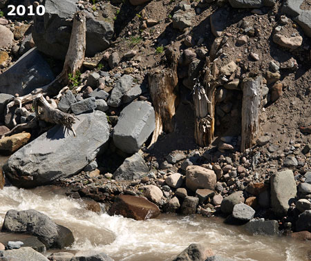
The Muddy Fork has only recently carved its way down through the 2002-03 debris to the original valley floor, revealing mummified stumps from the old forest and visible giving scale to the scope of the event (below).

Seven years after the 2002-03 flow, the Muddy Fork had cut a channel down to its original elevation, revealing the full depth of the flow.

Seven years after the 2002-03 flow, the Muddy Fork had cut a channel down to its original elevation, revealing the full depth of the flow.

These stumps of trees snapped off by the 2002-03 debris flow have reappeared where the Muddy Fork has carved down to the original river level.

These stumps of trees snapped off by the 2002-03 debris flow have reappeared where the Muddy Fork has carved down to the original river level.

With no way to know how long Mount Hood’s glaciers will continue to retreat, catastrophic events of this kind will recur in the coming decades. Runoff from the retreating glaciers will continue to carve away at newly exposed terrain once covered by ice, with periodic debris flows occurring as routine events.

In November 2006, another major flood event in the Sandy River canyon caused damage even further downstream, in the Brightwood area, where private homes line the Sandy River:

Damage from the 2006 flood was still being repaired when yet another major storm burst stormed down the valley in January 2011. During this event, a large section of Lolo Pass road briefly becoming part of the Sandy River, and scores of homes were cut off from emergency responders:

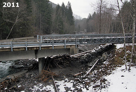
The 2011 event washed out the south approach to the Old Maid Flat Bridge over the Sandy River, forcing the Forest Service to jury-rig a temporary ramp to the bridge. The entire crossing has since been replaced, but like all repairs to streamside roads around the mountain, there is no reason to assume that another event won’t eventually destroy the new bridge, too.

The Old Maid Flat Bridge over the Sandy River was repaired with a temporary approach ramp (on the right in this photo) where the bridge approach had washed out by raging water

The Old Maid Flat Bridge over the Sandy River was repaired with a temporary approach ramp (on the right in this photo) where the bridge approach had washed out by raging water

The two homes in the distance barely survived the 2011 flood event on the Sandy River

The two homes in the distance barely survived the 2011 flood event on the Sandy River

This wider view shows the rebuilt section of Lolo Pass Road that was briefly a channel of the Sandy River during the January 2011 flood

This wider view shows the rebuilt section of Lolo Pass Road that was briefly a channel of the Sandy River during the January 2011 flood

Similar events have occurred over the past several years on the White River, Ladd Creek, East Fork Hood River and the Middle Fork Hood River. The predicted climate changes driving these events give every indication that we will continue to watch similar dramatic changes unfold around Mount Hood in decades to come.

The November 2006 debris flows in the White River canyon buried Highway 35 in boulders (ODOT)

The November 2006 debris flows in the White River canyon buried Highway 35 in boulders (ODOT)

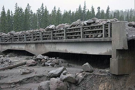
During the 2006 debris flows, the old White River Bridge was completely inundated, leaving an eight-foot layer of boulders on the bridge (ODOT)

During the 2006 debris flows, the old White River Bridge was completely inundated, leaving an eight-foot layer of boulders on the bridge (ODOT)

By late 2012, the Federal Highway Administration had built a new, much larger bridge over the White River designed to survive future debris flows

By late 2012, the Federal Highway Administration had built a new, much larger bridge over the White River designed to survive future debris flows

Just as the wildfires that burned through forests on the eastern and northern flanks of Mount Hood over the past few years have given us new insights into the cycle of forest renewal, the unfolding geological events linked to changing glaciers provide a similar opportunity to better understand these natural processes, too.

While these destructive events are tragic to our sentimental eyes, the rebirth of a forest ecosystem is truly remarkable to witness — as is the discovery of the Sandy Glacier ice caves in the midst of the larger decline of Mount Hood’s glaciers. All of these sweeping events are reminders that we’re just temporary spectators to ancient natural forces forever at work in shaping “our” mountain and its astoundingly complex ecosystems.

So, stay tuned and enjoy, this show is to be continued!
_________________________

OPB Airing Dates

Here are the broadcast dates for the Oregon Field Guide premiere:

• Thursday, October 10 at 8:30 p.m. on OPB TV
• Sunday, October 13 at 1:30 a.m. on OPB TV
• Sunday, October 13 at 6:30 p.m. on OPB TV

For fans of the show, a 25th Anniversary retrospective will also be airing on Thursday, October 3rd. You can learn more about OFG and view their video archive on their website.
_________________________

October 4th Postscript

Author with Brent McGregor on October 4

Author with Brent McGregor on October 4

In the small world department, I had the honor of meeting epic caver, climber and photographer extraordinaire Brent McGregor on the Timberline Trail this afternoon. He and caving partner Eric Guth had spent the night near the entrance to the Snow Dragon Glacier Cave!

After learning a LOT more about the Snow Dragon cave complex from Brent today (and having my jaw drop repeatedly as I heard about their exploits under the glacier!), I’ve updated the above article — including the more accurate use of the name Cerberus Moulin in lieu of the generic “glory hole” nickname that some hikers have been using.

Brent also pointed me to a couple fascinating new videos from OPB that just add to the anticipation of the Glacier Caves premiere on OPB:

Behind the Scenes of Glacier Caves: Mt. Hood’s Secret World

Special Glacier Caves website from OPB

And finally, one more link: the Glacier Caves OPB documentary will be screened in a free, special preview on October 9th at the Hollywood Theater. Here’s the link to the event Facebook page:

Glacier Caves Special Preview

Thanks for the terrific conversation, Brent – great meeting you and Eric!