Meet Brian Chambers!

BrianChambers01

Editors note: periodically, I feature local artists and writers in this blog. Brian Chambers is a local photographer in Hood River who has been capturing stunning images of Mount Hood and the Columbia River Gorge. Here’s a recent conversation with Brian.

Brian has also offered to donate a portion of any sales resulting from this interview to the Friends of the Gorge, Trailkeepers of Oregon (TKO) and the Columbia Land Trust, so be sure to mention the blog if you purchase Brian’s photos! (more info following the interview)

_______________

WyEast Blog: Great to meet you, Brian! How long have you been shooting landscape photography in the area?

Brian Chambers: I first came to Hood River on vacation in 1996. I immediately fell in love with the place and had moved here within one year. That was back in the old days of film. I had done a ton of photography way back in high school and had my own darkroom but did less and less as I got older. I was doing a little bit of photography when I moved here but it wasn’t until I bought my first DSLR in 2008 that my hobby became a full-blown addiction.

BrianChambers02SevenmileHill01

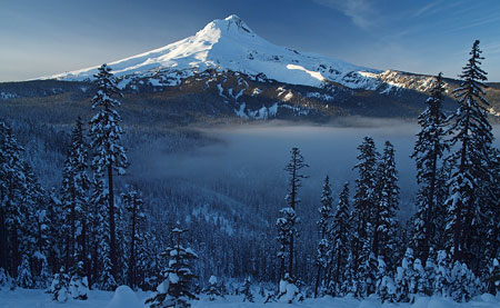
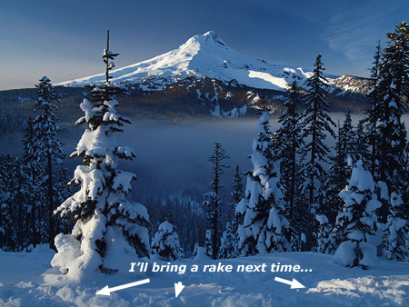
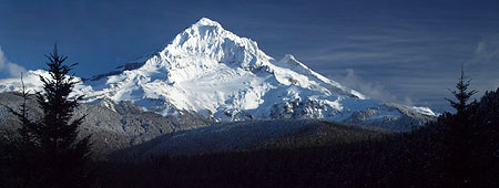
Mount Hood from the Eastern Gorge

(click here to view a large version in Brian’s gallery)

WyEast: What are your favorite Gorge locations for shooting – the ones you go back over and again?

Brian: It changes so much from year to year. I tend to find a new location and maybe pre-visualize some images in my mind. I will go back over and over until I am satisfied with the images I can capture with my camera. I will keep trying until I get that special combination of light and composition that really matches what I had seen in my mind.

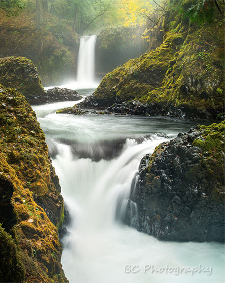
The thing I like the most about the gorge is the variety. If I had the energy I could shoot a fresh snow fall on a mountain stream at sunrise, at lunch take on moss covered waterfall, at sunset capture the most amazing wildflower scene, and a midnight capture an abandoned house in the middle of a wheat field. I really feel the options are arguably the best in the country.

BrianChambers03UpperHoodValley

Upper Hood River Valley orchards at sunrise

 (click here to view a large version in Brian’s gallery)

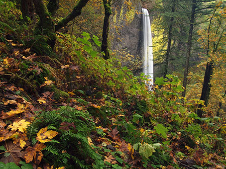
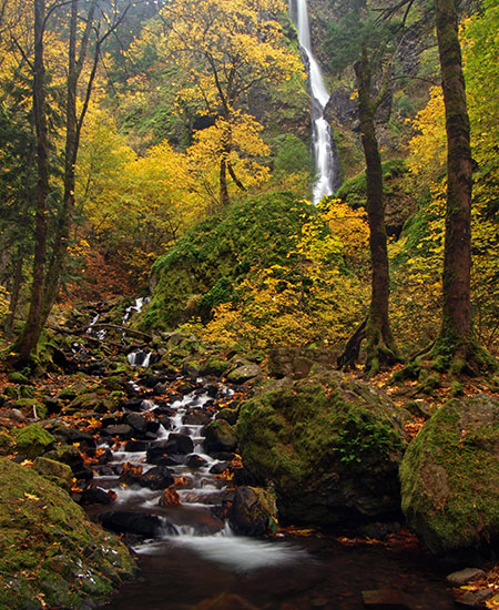
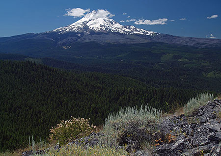
Some of my favorites include shooting the orchards of Hood River, Hood River itself with the river in the foreground and the mountain behind it, the view down the gorge anywhere there is exciting light from places like Rowena, Underwood viewpoint, Mitchell point. I have been heading to some of the more off-trail waterfalls and really enjoying the exploring aspect of that. I love Mt Adams in the fall for the color. I could go on all day.

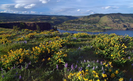
Early in the spring I am really drawn to the east hills. A few years ago it was the Rowena crest, then it was Dalles Mountain, then it was the Memaloose Hills Hike area.

BrianChambers04RowenaSunrise

Sunrise a Rowena Crest

(click here to view a large version in Brian’s gallery)

WyEast: What makes those locations special?

Brian: One big factor is the flowers. Especially this year, although it was an early bloom, it was off the charts good. I don’t think I have ever seen it that good. I love the openness of the land, being able to see the light interacting with terrain. The different compositional options, with 360 degree views and the amazing mountain and gorge views in the background. Sitting in a field of wildflowers all alone watching the rising sun dancing with Mount Hood and lighting up the flowers. It doesn’t get much better than that.

WyEast: What about your favorite Mount Hood locations?

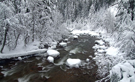
Brian: Well in the winter I spent a ton of time snowshoeing up the White River. It has such an easy access to an amazing mountain view with the river in the foreground. I am almost embarrassed to say how many times I have gone up there looking for the perfect light. I finally got a couple of images I am pretty happy with this year. Persistence can pay off.

BrianChambers05WhiteRiverSunrise

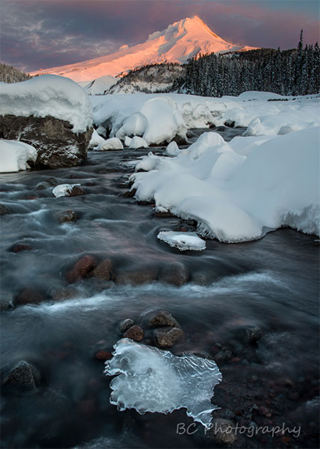
Sunrise on Mount Hood and the White River

 (click here to view a large version in Brian’s gallery)

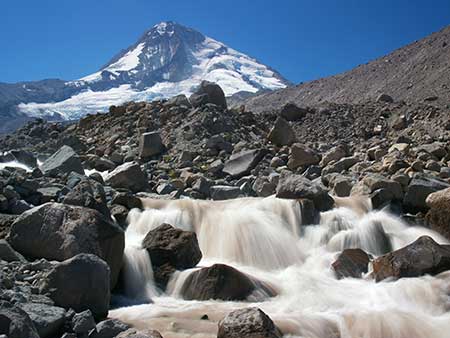
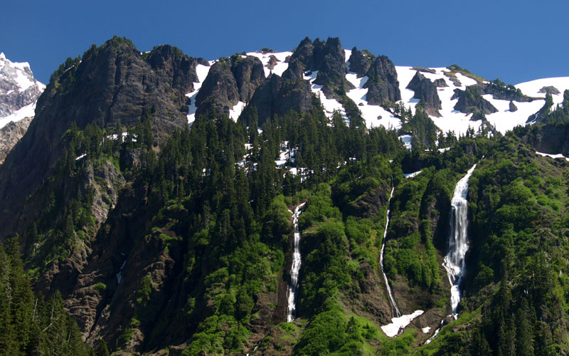
In the summer I often am heading up to the WyEast Basin and Cairn Basin area. I like that you can take several different trails to get there and it is this wonderful mix of high alpine, lush wildflowers, refreshing streams and small waterfalls with some of the best close-up views of the mountain. The number of great subjects in such a small area is almost mind-boggling.

WyEast: Some of your most stunning photos are shot during the golden hours of early morning or evening – do you have any tips for shooting in those conditions?

Brian: Getting up earlier and staying out later is usually the simplest thing people can do to greatly improve their photography. It is very difficult to get as compelling a photo in the middle of the day. The rapidly changing light around sunrise and sunset can really add a ton of interest, color and excitement to your images. Watch the sky, satellite images and weather forecasts to see if there is going to be enough clouds to make the sky interesting but not too many so that the sun is blocked.

BrianChambers06CairnBasin

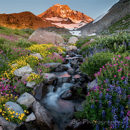
Late afternoon wildflowers near Cairn Basin on Mount Hood

 (click here to view a large version in Brian’s gallery)

A tripod is critical for getting clear shots when it is darker. I suggest shooting in RAW not JPEG and bracketing your exposures to capture all of the detail in the brightest and darkest parts of the image.

Be Patient. I can’t tell you the number of times I have been taking pictures and all the other photographers have left and 10 minutes after a boring sunset the sky just lights up.

BrianChambers07AdamsSunset

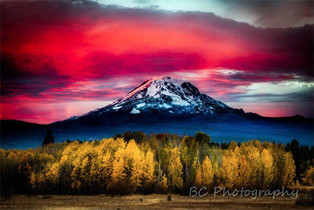
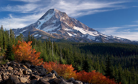
Autumn sunset at Mount Adams

(click here to view a large version in Brian’s gallery)

That being said, I would be lying if I didn’t say I am just like everyone else in that I sometimes can’t pull myself out of bed in the early morning and I sometimes head to the brewpub at sunset rather than out to shoot. My family is pretty tolerant of me heading out to shoot but I try to balance life and responsibility with photography. Find the balance that makes you happy.

WyEast: You also have some amazing photos that feature the night sky. How exactly do you capture those images?

Brian: It is surprisingly easy if you have a fairly new digital camera. Have a solid tripod. I suggest getting to your location before it gets dark. Set up all your gear, compose your image and focus. Cameras are unable to auto-focus in the dark so you need to focus before it gets too dark and then set your camera to manual focus so it will not try to refocus.

Start taking pictures before it is totally dark and see what happens. Learn how to adjust your camera in manual exposure. Set your aperture to wide open (the smallest number possible), your shutter speed to around 20 or 30 seconds. Crank your ISO up to 800 or 1600 or even higher and fire away. The beauty of digital is it doesn’t hurt to mess up. If it is too dark crank up your ISO higher or lengthen your shutter speed. If it is too bright turn your ISO down.  Look at your results and see what works and what doesn’t. Play and have fun.

BrianChambers08CooperSpurStars

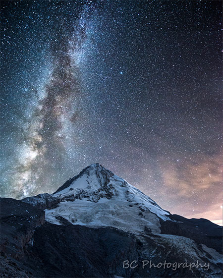
Milky Way and Mount Hood from below Cooper Spur

 (click here to view a large version in Brian’s gallery)

WyEast: Those are great tips! Some of your images of Mount Hood and the Gorge also feature lightning, which seems especially challenging to capture. Other than not standing on high ground – which, actually, it looks like you were – what can you tell us about getting a great lightning photo?

Brian: First of all be safe. I think a lot photographers tell stories of risking life and limb to “get the shot”. Probably not worth it and often just an embellishment to make it sound more dramatic. I like to find a place where I can shoot while sitting in the car or at least find shelter immediately.

BrianChambers09EastGorgeLightning

Thunderstorm lighting up the East Gorge

(click here to view a large version in Brian’s gallery)

It helps to have a cable release or some other way of triggering your camera like a remote control. That allows you to be safe in the car while the camera is outside. If it is dark and you can use a long exposure you can just set the camera to shoot continuously. Sort of a “spray and pray” method but there is nothing worse than missing that solitary lightning bolt.

If it is daylight, the “spray and pray” method doesn’t work because most cameras get bogged down and stop shooting after 20 seconds or so. In that case you can just watch and try to push the button with every strike. It sounds impossible but it can work with a little practice. We don’t get much lightning here so I have yet to invest in a lightning trigger but it’s a device that senses the lightning and takes the photo for you. Pretty handy if you do a ton of lightning shots.

BrianChambers10LostLakeLightning

Lightning at Mount Hood and Lost Lake

 (click here to view a large version in Brian’s gallery)

I have a couple of apps that show you live lightning hits so you can see if it’s worth heading out. And be ready if the conditions change. One of my favorite lightning shots at Lost Lake (above) was purely luck. I was there to take a photo of the sunset when a small storm popped up. I kept taking pictures until I got my shot.

WyEast: You’re based in Hood River, Brian. I’m wondering where you see the fine art scene going in the Gorge over the long term? Do you see art becoming a significant part of the Gorge and Mount Hood economy in the future?

Brian: It is definitely growing. I don’t think there were any art galleries in town when I moved here in 1997. Now it seems like there is one on every block. Many restaurants and breweries also display local artists. Hood River has over 20 new outdoor works of art on display around town. There are so many talented artists in the gorge. I think people are drawn to the quality of life and inspired by amazing beauty at our doorstep.

BrianChambers11StormyGorge

Stormy Gorge evening

(click here to view a large version in Brian’s gallery)

Art can play a significant part in the economy. It is just one more great reason for people to visit the gorge and it fits well with the winery and brewery tours, the Fruit Loop orchard tour and outdoor recreational tourism that the gorge is so rightly known for. I think the artwork can be a long-term reminder of the specialness of the area and for both tourists and people who live here. I love when people look at one of my pictures and it reminds them of some special times they have had here.

BrianChambers12SpiritFalls

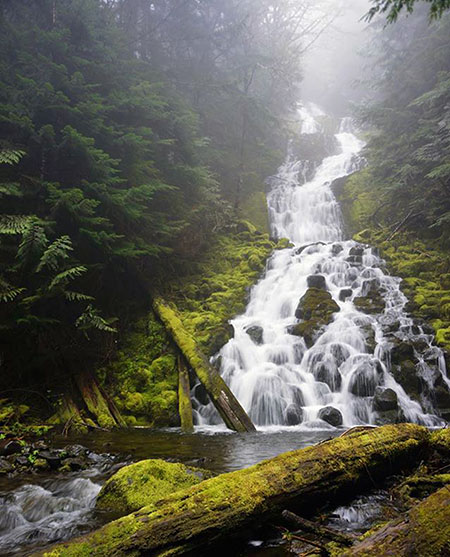
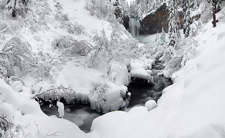
Spirit Falls on the Little White Salmon River

(click here to view a large version in Brian’s gallery)

One thing that I am very excited about is helping to organize a temporary art gallery event in downtown Hood River on July 1st -3rd week. Eighteen local artists, including myself, have banded together to showcase and hopefully sell our work. We are having beer and wine and small plates of food, with an opportunity to view work from wide variety of different types of artists.

We will all be on hand all three days to discuss our artwork. The event will be at 301 Oak Street in downtown Hood River. I encourage anyone interested to stop in and say “hello”!

WyEast: That sounds like a great event, Brian! As an artist working in the Gorge, what are some of the challenges you’ve faced in becoming established?

Brian: It has been a slow steady process. Sometimes it seems agonizingly slow.  When I first started taking pictures I didn’t dream that people would want to purchase them. I looked around and saw so many great photographers.

BrianChambers13DufurHomestead

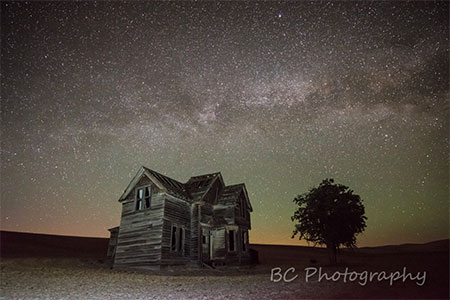
Abandoned homestead near Dufur, Oregon

 (click here to view a large version in Brian’s gallery)

Early in my progression as a photographer I was lucky enough to be accepted into the Columbia Center for the Arts. At that time it was a critical place of support for me. They encouraged me and treated me as a true artist so that I began to think of myself that way. I started to sell some work and began to grow in confidence. Every year they would have a photo contest and I was fortunate enough to win first place among hundreds of entries, including some really talented photographers.

That was a big step for me. Then I branched out and started displaying my work in local bakeries, restaurants and brewpubs. I started to gain more followers and confidence. In the last year or so, I have started to post more consistently on Facebook (www.facebook.com/BrianChambersPhotography/) and connect with people there.

BrianChambers14GorgeHike

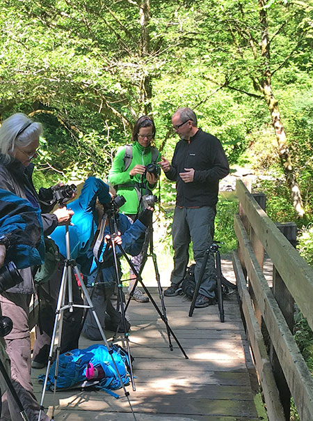
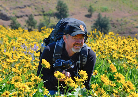
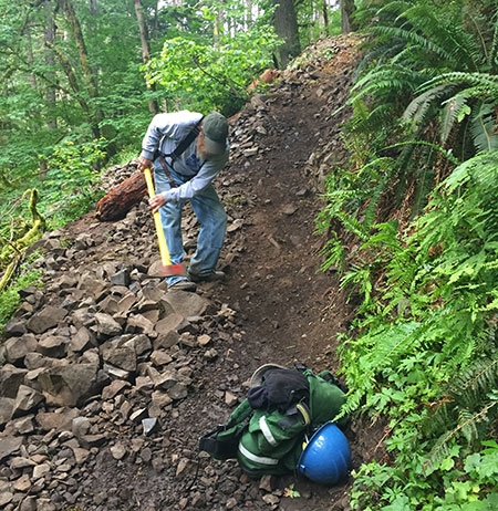
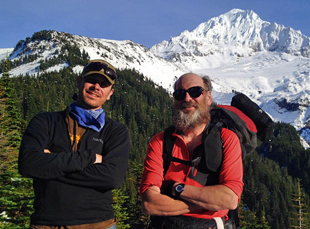
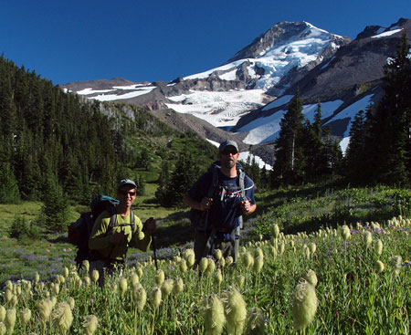
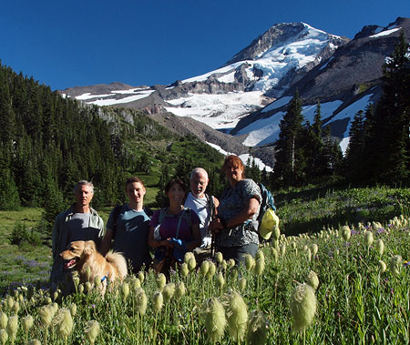
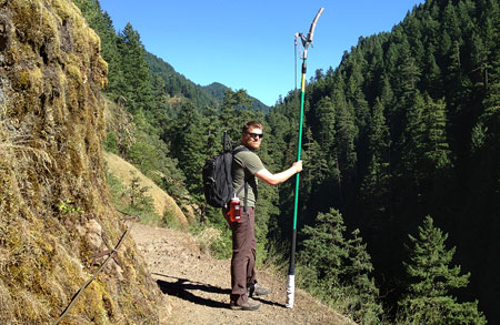
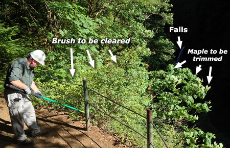
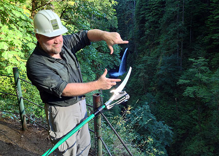
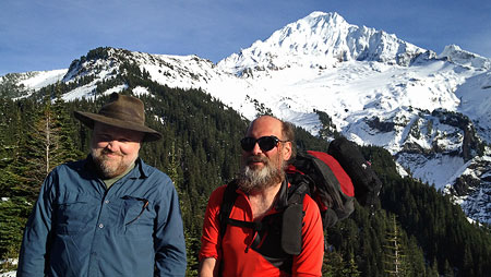
Brian teaching photography on a recent Friends of the Gorge outing

I have also begun teaching a little (including the Friends of the Gorge hike where we met). It is something I really enjoy and want to get better at, and something I have considered doing more frequently in the future.

Hood River is full of talented photographers and artists and most of them have been really supportive and welcoming to me.

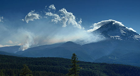
WyEast: When we met recently on that Friends of the Gorge hike, we talked about the controversy over oil and coal trains traveling through the Gorge. Since then, of course, a worst-case scenario unfolded when an oil train derailed in Mosier on June 3 of this year. What are your thoughts on the oil and coal trains moving through the Columbia River rail corridor?

Brian: That was a real eye opener for me.  I had been out for a road bike ride in the exact location ½ hour before the accident. When I heard about it I actually went to take pictures from across the river. You can see a time lapse I took on my Facebook page. Just watching all the black smoke block out the view of Mt Hood was really a horrible sight.

BrianChambers14OilTrainStill

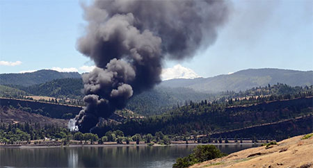
Brian captured this video of the June 3rd oil train crash in Mosier, Oregon

 (click here to view a large version of this video in Brian’s gallery)

I got stuck in a traffic jam heading home. It took me 2 hours to get home when it would normally take me 10 or 15 minutes. It really made me think about how the unique geography and infrastructure of the Gorge can really amplify any disaster. There are very limited driving options, and if one or two roads are closed people can become trapped.

I also think the accident was not a worst-case scenario. It was lucky it didn’t happen in the center of Mosier or Hood River, where there is a lot more potential for damage and it was lucky it happened on an unusually light wind day. If it had been windy I can only imagine how bad the fire could have been.

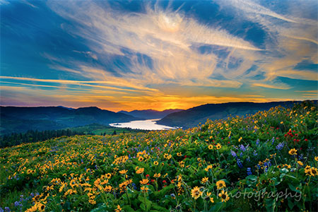
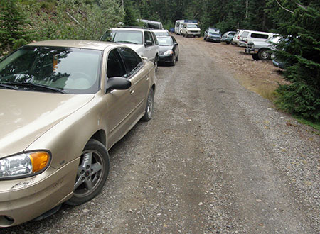
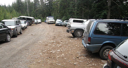
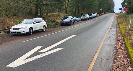
WyEast: You’ve hiked the trails of Mount Hood and the Gorge and have seen the growing crowds. Many are concerned that the area is being loved to death. What are your thoughts?

Brian: Wow, what a question. This is something I think about almost daily. Even in my short time here I have seen a tremendous change in the volume of hikers to areas that were once quiet and relatively unknown, like the Columbia Hills Park and Memaloose Hills. I used to go there in the spring and see almost no one. This year they were just packed with people. Which, on one hand, is wonderful that people are out there learning to love the gorge and discovering new places. It is great for society that people are out exercising and recharging in nature. I feel like people will fight to save places once they see how special they are.

BrianChambers16ColumbiaHills

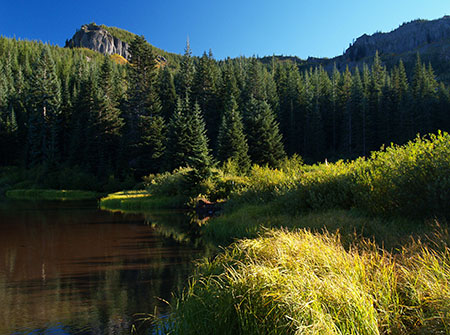
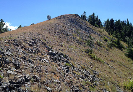
Columbia Hills State Park in spring

 (click here to view a large version in Brian’s gallery)

On the other hand, overcrowded trails and unsafe parking lots are a real concern and take away from everyone’s enjoyment.  As a photographer, I am always looking for the un-crowded wild places and I am afraid as I share them I might be contributing to them becoming crowded and over used.

There is an area near The Dalles that I am just in love with right now and I went there more than a dozen times the last couple years during the wildflower bloom and saw less than a handful of other hikers, and usually didn’t see anyone. Although part of the reason for that is starting my hike before 5 AM! I am torn between never telling anyone about it and wanting everyone to know how amazing it is. The word is already getting out and I suspect it will be packed in a couple years.

BrianChambers17SevenmileHill02

Mount Hood from an “undisclosed location”…

 (click here to view a large version in Brian’s gallery)

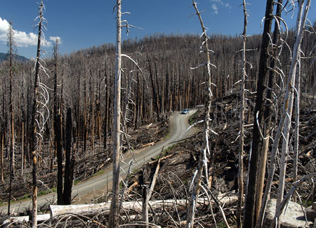
I guess I am an optimist. Nature seems to have the ability to not just heal people, but also itself. Just last week I was walking through the Dollar lake fire on Mt Hood. A few years ago it was a scene of total destruction. Everything dead and blackened. Now it’s hard to see the ground due to the huge number of flowers. If we can just try to get out of the way the land can usually do amazing things to recover from damage.

BrianChambers18GorgeSunset

Gorge Sunset near Mitchell Point

 (click here to view a large version in Brian’s gallery)

Ultimately, I think the best answer is more trails. That is why I fully support the work you and others like you are doing. Saving the remaining wild places and creating sustainable hiking trails. I hope as the crowds worsen that will become a bigger priority for more and more people.

WyEast: Last question, and one you probably knew was coming: you’re a veterinarian by trade, so I’m wondering if you’d like to weigh in on bringing dogs into the Gorge? And in particular, what are some tips you would offer for keeping dogs (and people) safe, based on your experiences as a care giver?

Brian: Well, one disease that people new to the area may not have heard of is salmon poisoning. Don’t let your dog eat raw salmon or steelhead. It can cause severe vomiting and diarrhea that can be fatal. As I am sure all hikers already know, there are a few ticks in the area! There are plenty of good tick control medications available for your dog.
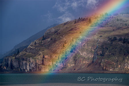
BrianChambers19GorgeRainbow

East Gorge rainbow

 (click here to view a large version in Brian’s gallery)

There are lots of dangers out on the trails and roads most of which can be avoided by keeping your dog on a leash and using common sense. I just recently saw a dog that was bitten by a rattlesnake on Dog Mountain. I have seen dogs killed by heat stroke, dogs killed by trains, falls from cliffs, cuts caused by skis, dogs lost in the wilderness, attacked by coyotes and other wild animals, falls from the back of pickup trucks, and too many hit by cars to count.

We also have a lot of poison oak in the Gorge. Keeping your dog on a leash is also a good way to make sure he stays out of poison oak, which can also be transferred to you from your dog’s coat.

BrianChambers20McCallSunset

Spring sunset in the Gorge from Memaloose Hills

 (click here to view a large version in Brian’s gallery)

Lastly, just like you and I, you should avoid overdoing the activity level for your dog’s fitness level. If you have an out of shape dog that doesn’t exercise, don’t start with a long bike ride on a hot day. As your dog starts to age you need to start to reduce the length of the hikes and bikes to ones that will not cause them pain or distress.

It can be hard to do because the dogs often want to go, even when their body is unable. Talk with your vet if your dog is slowing down or seeming stiff and sore, as there are plenty of options to help with that.

WyEast: That’s great information! Thanks for taking the time to chat, Brian – and for celebrating the Gorge and Mount Hood with your amazing photography. We look forward to seeing more of your work!

Brian: It really was my pleasure.

_______________

You can support Brian Chambers’ photography by following him on Facebook:

Brian Chambers Photography on Facebook

Through July 15th, Brian will be donating 20% of proceeds from photos he sells to people who mention this article to the Friends of the Gorge, Trailkeepers of Oregon (TKO) and the Columbia Land Trust, so it’s a great time to support him! (please note that this excludes the July 1-3 pop up gallery)

 Check out more of Brian’s images at:

Brian Chambers Gallery on Zenfolio

 And you can contact Brian directly through e-mail by clicking here.

And finally, learn more about the July 1-3 pop up art gallery in Hood River at:

Art in the Gorge on Facebook


The High Cost of Free Parking (part 2 of 2)

ParkingCostPartTwo01

Cars now overflow the remote Vista Ridge trailhead routinely

This is the second in a two-part series that takes its name from Donald Shoup’s ground-breaking book “The High Cost of Free Parking”, first published in 2005. Shoup documents the many unintended effects of free parking in cities, and many of his proven principles could apply to trailheads in our public lands, as well.

The second part in this series explores some possible solutions for the parking crisis facing the trailheads of the Columbia River Gorge and Mount Hood, and the value of confronting the true costs of free parking to our most treasured public lands.
__________________

No more free parking!

Does anyone really expect free parking at a Timbers or Blazers game, or drop in for dinner without a reservation at one of Portland’s finest restaurants to find a table waiting? Or be exempted from tolls when crossing the Columbia at Hood River and the Bridge of the Gods in Cascade Locks? Of course not, but that doesn’t mean we don’t reserve the right to complain about it! That’s human nature.

ParkingCostPartTwo02

Bumper-to-bumper at Vista Ridge on a Friday

Such is the dilemma for public land managers face as they attempt to impose limits on access to our trails on Mount Hood and in the Gorge. While we can all probably agree that the impacts we now see from overuse require limits on access, we’d probably like someone else to suffer the inconvenience.

The good news is that our most overused trails are relatively few in number. Any seasoned hiker can rattle them off, as many already avoid these trails on popular weekends and seasons: Angels Rest, McCord Creek, Wahclella Falls and Eagle Creek in the Gorge are now infamous for their crowds, while Ramona Falls, Mirror Lake, Salmon River, Elk Meadows and (most recently) Tamanawas Falls on Mount Hood see overflowing weekend crowds.

ParkingCostPartTwo03

Frustrated hikers pushed out of the Wahclella Falls trailhead have resorted to parking on the I-84 off-ramp

Experienced hikers already know where the lesser-visited trails are and make a point of steering toward these places for a quieter, better outdoor experience. However, as the Portland region continues its rapid growth, even some of these “secret” trails are starting to show some strain: Herman Creek, Starvation Ridge and Gorton Creek in the Gorge and Vista Ridge, Bald Mountain and Cooper Spur have all seen spikes in use over the past decade or so as hikers seek less crowded trails.

We have met the enemy and he is… us!

The first step in adopting a trailhead parking policy to address overcrowding is to recognize the problem: when trailheads routinely overflow, it’s a problem! You can see this on weekends on every one of the overcrowded trails mentioned above. The crowding is now year-round in the Gorge and whenever the ground is snow-free up on Mount Hood.

For some trails, like Mirror Lake and Eagle Creek, the crowds extend beyond the weekends, especially on Fridays and Mondays. But even on these most heavily used trails, weekdays usually mean plenty of parking to spare, with no overflow.

This variation in day-to-day use at the most crowded trailheads is a case study for variable parking fee, with fees set higher on weekends and holidays, and lower (or not at all) on weekdays. As Donald Shoup demonstrates in “The High Cost of Free Parking”, adopting such a strategy can shift weekend and holiday use to less popular trailheads with free parking, or to non-peak days at more popular trailheads.

ParkingCostPartTwo04

The popular Wahclella Falls trailhead still has open spaces on most weekdays

If we adopted a variable pricing policy tomorrow for overused trailheads in the Gorge, we could cut weekend crowding on trails now being harmed by overuse in half, overnight. Sounds easy, right? Well, one complication comes from the public blowback that would almost certainly occur. Remember, we all reserve the right to complain when things aren’t free!

Another complication comes from the fact that several of the most popular trailheads also have heavy tourist use. Places like Horsetail Falls, Wahkeena Falls and Multnomah Falls in “waterfall alley” are good examples where the majority of peak period visitors aren’t hikers, just people touring the Historic Columbia River Highway and walking the paved paths to the most famous roadside views.

Shared tourism and hiking trailheads should be priced, too, as they fit the same definition for overcrowding with parking spilling far beyond established parking areas. Crowding is crowding.

ParkingCostPartTwo05

The impacts of overuse in the Gorge are real and jarring. This boot path cutting a switchback on the Oneonta Creek trail formed in just the past two years.

At Multnomah Falls, a new hazard has emerged from the overflow on weekends, with visitors now parking beyond the narrow historic highway viaducts that flank the falls and lodge. Signs on the viaducts sternly warn against pedestrians walking along them, but whole families are now a common sight in the narrow viaduct vehicle lanes on busy spring and summer weekends at Multnomah Falls.

At Oneonta Gorge, the huge overflow of visitors has created a hazard for hikers attempting to scale the log jam at the mouth of the gorge, and ruined the outdoor experience for those who make it beyond the log pile with a noisy, carnival atmosphere.

ParkingCostPartTwo06

Vandals have almost completely carved up the walls of the restored Oneonta Tunnel since it opened six years ago…

ParkingCostPartTwo07

…a testament to the destructive behavior that allowing large crowds to from on our public lands can foster?

Worse, the overcrowding at Oneonta has led to a shameful degree of vandalism in the recently restored highway tunnel. Would vandals pay to park here? Perhaps, but at least the crowds that lead to that sort of destructive behavior could be prevented with managed parking. Otherwise, this precious gem will likely have to be closed to the public, once again.

At Mount Hood, overcrowding at places like the Salmon River Trail and Ramona Falls has also led to vandalism and car break-ins, in addition to heavy impacts on trails. Managed parking could greatly improve the situation here, while allowing hikers to discover the many lesser-used trails on Mount Hood that could benefit from more boot traffic while providing a far better hiking experience.

ParkingCostPartTwo08

A relatively quiet weekday at the massive (and overflowing on weekends) Ramona Falls trailhead

In many of these examples, a parking pass is already required today, but this has little effect on managing peak use. The key difference is variable pricing for parking that provides an incentive for visitors to avoid peak periods at the busiest trailheads, but gives options of other trails or off-peak days when little or no parking fee is charged. It’s a proven approach whose time as come in our most visited public lands.

…and now transit!

Since proposing a “Boot Loop” transit service on this blog four years ago, we’ve seen significant steps forward in providing transit service to Mount Hood and the Gorge. The Mount Hood Express now provides daily service from the Portland area and on the Washington side of the Gorge, transit service now connects to Stevenson, with a new shuttle to Dog Mountain.

ParkingCostPartTwo09

The new Mount Hood Express bus provides daily service to the mountain.

On the Oregon side of the Gorge, the Oregon Department of Transportation (ODOT) is partway through a pilot project to bring transit service to the most heavily visited spots in the Gorge. ODOT plans to provide service from a park-and-ride location inside the Portland area to the most popular trailheads in the Gorge.

Transit service provides a needed option to driving, especially for those who do not have access to a private vehicle, but also to those who simply want to avoid the hassle of driving (and parking).

Transit is also a good counterpoint to adopting a parking strategy for the Gorge and Mount Hood, as parking fees provide an incentive to use transit during peak periods, which in turn, helps provide the critical mass to keep the service going. This is a tried and proven relationship between parking policy and transit in cities, and overdue as a strategy in our most heavily used recreation sites.

ParkingCostPartTwo10

Park transit station at Niagara Falls State Park, New York

That said, transit is mostly a way to provide another option for visitors. It simply won’t have the capacity to have much impact on overall visitation during peak periods, when parking areas at our most popular trailheads is already overflowing to two or three times the planned capacity for the trail.

How could this work?

Applying Donald Shoup’s parking management practices to recreation areas is less complicated than in an urban setting for the simple fact that there are so few places to manage, most have a single entrance point and they are all in public ownership.

ParkingCostPartTwo11

The Forest Service recently completed a major remodel of the Wahkeena Falls wayside to better manage crowds, but without managing parking, this new landscaping doesn’t stand a chance of surviving the overload.

The public reaction to actually putting a price on parking at our busiest trailheads, even during peak periods, is the driver for why we aren’t already attempting this – not the complexity of actually making it work. After all, cities around the world are already doing it, and against much more complex obstacles.

So, what are the parking management tools that could be borrowed from cities? Here are some that could work in the Gorge and on Mount Hood:

ParkingCostPartTwo12a

ParkingCostPartTwo12e

ParkingCostPartTwo12d

ParkingCostPartTwo12c

ParkingCostPartTwo12b

These systems are all being used in cities today, and some combination of these practices could be applied to parking on our public lands. One challenge for public lands would be on-site enforcement, however, as this is an essential ingredient for urban parking policies.

On this point, I propose that a portion of the trailhead parking revenue could be steered toward dedicated county law enforcement to patrol parking areas. Not only would this provide an essential incentive for visitors to pay their fee, but it would also bring a much-needed security presence for busy trailheads that are increasingly targeted for car break-ins.

ParkingCostPartTwo13

The Starvation Creek wayside does triple duty as a popular trailhead, wayside for tourists and freeway rest stop. This site is a candidate for a combination of short-term timed parking and long-term fee parking.

So, how much revenue does a parking strategy generate? Well, consider that the City of Portland collects some $35 million annually in parking fees from its downtown meters, which in turn contributes to the city’s transportation budget for street maintenance. The city also collects another $7 million annually in fines for parking violators, more than enough to cover its enforcement costs.

While a parking strategy for the Gorge or Mount Hood would be unlikely to bring that much parking revenue, the Portland model does show that fee parking at the most popular trailheads in the Gorge and on Mount Hood could not only cover operational costs, but also bring new revenue for woefully underfunded trail maintenance and construction. That could be a valuable selling point to regular hikers and visitors.

Those pesky agency permits…

One of the institutional obstacles to adopting a coordinated parking strategy for the Gorge, in particular, is the mix of land management agencies involved: the U.S. Forest Service, Oregon Parks and Recreation Department (OPRD) and Washington Department of Natural Resources (DNR) all have some sort of parking permit that applies to some of their respective recreation sites.

ParkingCostPartTwo14

Welcome to Wahclella Falls! Forest Pass or $5 fee required… here.

The Forest Service and OPRD both have a mix of free and fee sites, with the Forest Service requiring a $30 annual Northwest Forest Pass or $5 day-use fee at places like Eagle Creek or Wahclella Falls, but no charge at its busiest locations like Multnomah Falls, Horsetail Falls and Wahkeena Falls, where tourists outnumber hikers. OPRD charges $5 day-use fees at places like Rooster Rock and Benson Lake, but not at busy trailheads like McCord Creek and Latourell Falls.

Meanwhile, on the Washington side of the Columbia, DNR charges a $30 annual fee or $10 daily fee for its Discover Pass to park at places like Beacon Rock, Hamilton Mountain and all other Washington State recreation areas.

All of these are flat-fee permits, so they do nothing to help discourage overcrowding on busy weekends and arguably encourage more use, since an annual fee provides a flat rate for unlimited visits. In fact, the annual passes do just the opposite, encouraging multiple visits for a flat rate. There’s nothing wrong with hikers spending a lot of time in the Gorge, of course, but we all share the burden when it comes to managing the impacts through trailhead parking fees.

ParkingCostPartTwo15

It’s unclear how much revenue is left for trails once administration costs for the Northwest Forest Pass are covered.

Today, trailhead permits are pitched for their ability to generate funds to build and maintain trails, but hikers are rightly skeptical about how much funding actually goes to trails. In the end, it’s not a problem of the trail passes, but rather, by the low fees relative to the trail impacts the most popular trails are experiencing.

For example, a hiker purchasing an annual permit for $30 and spending a dozen days in the Gorge or on Mount Hood each year pays just $2.50 per visit to cover their trail impacts, or less than many hikers will spend on coffee en route to the trailhead.

ParkingCostPartTwo16

Lots of passes and hassle, not much revenue for trails… and no impact on crowding.

There is little chance the states of Oregon and Washington and the U.S. Forest Service will ever join forces and create a unified trail pass, and besides, their pass systems aren’t effective at managing peak use, anyway. Instead, they should cooperate to adopt a pricing strategy for our most overused trails that is an add-on to (or replacement for) the existing pass system at these locations.

The ethics of putting a price on parking?

At this point, you might be thinking (as I generally do) that we should all enjoy free access to our public lands. Of course we should! We pay for tem every April 15, after all. Thus, adding parking fees at our overused trails will most certainly bring howls from avid hikers who spend a lot of time on the trail, and who dutifully purchase their $30 annual trail passes now.

ParkingCostPartTwo17

Would revenue from a parking policy bring more of this to the Gorge and Mount Hood? Almost certainly, if managed properly.

Yet, when overuse starts to bring the “tragedy of the commons” to our most cherished places, it’s time for all of us to step up and find a solution. Putting a price on parking is a proven and effective way to get there. More importantly, pricing is really only needed on our most heavily traveled trails. Most trails will continue to be “free”… of a parking fee, anyway.

Putting a price on parking arguably discriminates against people with limited incomes or who are unable to visit in off-peak periods when little or no fee is required. Land managers will therefore need to consider ways to ensure that everyone can visit our public lands, no matter their ability to pay. But such programs are already in place in several state and National Parks, and could be easily included in a Gorge or Mount Hood parking strategy.

ParkingCostPartTwo18

That’s no road – it’s what the Angels Rest trail has become in recent years, thanks to massive overuse from a complete lack of parking management at the trailhead.

Today, land managers are already beginning to put restrictions on overflow parking in the Gorge and on Mount Hood. It’s a good first step, but not enough to address peak demand on weekends and holidays, and in the end will mostly frustrate visitors who have arrived expecting place to park.

The next step for our public agencies is to start managing parking, itself. It’s long past time to try it in the Gorge and on Mount Hood, for the sake of our trails and most treasured places.

A New Vision for Mirror Lake (Part 3 of 3)

MirrorLakeVision01

Mirror Lake and Mount Hood from Tom Dick and Harry Mountain

 Big changes are coming to the Mirror Lake Trail on Mount Hood, perhaps the single most visited trail on the mountain. This is the third in a three-part series on the future of Mirror Lake, and the need for a broader vision to guide recreation in the area. This article focuses on a (much!) bolder vision that would provide new backcountry experiences and help take pressure off heavily visited Mirror Lake.

_____________

On March 30, 2009, President Obama signed into law a wilderness bill that brought thousands of acres of land around Mount Hood under permanent protection from logging and other commercial development.

Most of these new areas were expansions of existing wilderness, and such was the case for the backcountry that forms the backdrop for Mirror Lake. This new wilderness area stands as an island, bounded by US 26 on the north and the Still Creek Road on the south. This map shows the new island of wilderness:

MirrorLakeVision02

Click here for a larger map

The new wilderness area encompasses most of the remote, seldom visited Wind Creek drainage and much of Tom Dick and Harry Mountain. As you can see from the map, this island wilderness was added to the nearby Salmon-Huckleberry Wilderness, located to the south. That might be because the new area falls below the 5,000 acre threshold for new wilderness, but it was a missed opportunity to give the area its own wilderness identity.

While Mirror Lake, itself, was left just outside the boundary, the rugged mountain backdrop above the lake is now protected in perpetuity from development, and ski resort expansion, in particular — and whatever else might have been dreamed up by those trying to exploit this beautiful area to make a buck off our public lands.

MirrorLakeVision03

The rugged slopes of Tom Dick and Harry Mountain rising above Mirror Lake are now protected forever

The new wilderness protection also offers an opportunity to rethink how Mirror Lake itself will be protected in the long term. While not the closest wilderness area to the Portland region, it is perhaps the most accessible. That means demand for exploring the Mirror Lake area will only grow over time, no matter where the new trailhead is eventually located.

The Mirror Lake trailhead study took a baby step toward a broader vision for the wilderness area with the intriguing (and now discarded) “Site 5”, which would have moved the trailhead to the base of Laurel Hill, along Camp Creek (see below). Forest Service planners considered a new trail along Camp Creek to connect this lower trailhead to the existing trail – and in doing so, briefly floated the idea of a completely new streamside hike, something the Mount Hood area is woefully short on.

MirrorLakeVision04

Click here for a larger map

It’s true this site would have been a poor replacement for the existing trailhead, simply because of its distance from Mirror Lake. But the idea should be still explored on its own merits – along with other opportunities to build a true trail network in the new Mirror Lake wilderness.

While the Forest Service is rightly concerned about the impacts of heavy foot traffic on Mirror Lake, making it more difficult to get there doesn’t solve the larger issue: over the next 25 years, a million new residents are expected in the greater Portland region, and new trails are essential to spreading out the already overwhelming demand from hikers.

MirrorLakeVision05

Mount Hood from Tom Dick and Harry Mountain

But you might be surprised to know there are no plans to do so. For a variety of frustrating reasons, the Forest Service is doing just the opposite: hundreds of miles of trails are suffering from serious maintenance backlogs, and the agency is actively looking for trails to drop from the maintained network across the Pacific Northwest.

At Mount Hood, the Forest Service is still working from a decades-old forest plan that was written when the Portland region was smaller by about 800,000 residents. In that time, you can count new trails added to the system on one hand – while dozens of legacy trails have been dropped from maintenance. We hear that there’s no just money for trails – and yet, millions are spent each year on the other programs that are clearly a greater Forest Service priority.

To reverse this counter-intuitive downward spiral, the first step is a bold vision to shift the agency toward embracing new trails, and moving recreation to the top of their priorities for Mount Hood. The Mirror Lake area is a perfect place to start.

Taking the Long View

New trail proposals are a regular feature in this blog, but they are usually very specific fixes to a particular trail that should happen in the near term (with a couple of notable exceptions focused on backcountry cycling, found here and here.

The following proposal is different: this is a trail concept that would likely be built over years and decades, but with an eye toward a complete system over the long term. The goal is to absorb some of the inevitable growth in demand for trails while also offering a reasonable wilderness experience.

The proposal comes in two parts. The first focuses on Mirror Lake and the adjacent island of wilderness that encompasses the Wind Creek Basin, while the second part focuses on connections to the main Salmon-Huckleberry Wilderness, to the south. The trail concepts for the first part are shown on this map:

MirrorLakeVision06

Click here for a larger map

The trails shown in red on the map are new trail proposals, and would be built over time to provide alternatives to the overused Mirror Lake trail. Trails in green exist today. The new trails would provide access to new, largely unknown scenic destinations in this pocket wilderness, as well as overnight wilderness camping potential for weekend backpackers.

A key piece in this trail concept is a pair of new routes that would create a Mirror Lake loop from the proposed trailhead at Ski Bowl (see close-up map, below).

MirrorLakeVision06a

Click here for a larger map

While the other trail concepts proposed in this article are intended as a long-term, alternative vision to the status quo in the Mirror Lake area, the Mirror Lake loop trails could – and should — happen in the near term. The Mirror Lake loop concept builds on existing trails and could be built today, if the Forest Service were to embrace the idea.

The new connecting trail from the proposed Ski Bowl trailhead is already part of the Forest Service proposal for relocating the existing trailhead, and will be constructed as part of moving the trailhead.

MirrorLakeVision07

The Tom Dick and Harry traverse concept (the 1.3 mile connector along the north slope of the mountain) could be an important complement to the existing up-and-back trail by offering a loop option. The connector would also provide a real trail alternative to the informal summit ridge trail that eventually ends up following service roads under ski lifts back to the trailhead.

Loop trails not only reduce the impact on individual routes, they also offer more scenery for hikers and less crowding – which helps ensure a better wilderness experience.

MirrorLakeVision08

Moving to the north edge of the Mirror Lake trail concept map, the “Site 5” idea of a lower trailhead along Camp Creek is included, connecting from the Site 5 trailhead location to the Mirror Lake Trail.

While this trail concept seems to be too close to the US 26 highway corridor to provide much of a respite from urban noise, the saving grace is Camp Creek, itself. The creek tumbles along several hundred feet below the, and the sounds of this mountain stream would be more than enough to mask highway noise for hikers if the trail were designed to follow the creek.

MirrorLakeVision09

Looking down… waay down at Camp Creek from Highway 26

The Camp Creek trail concept has a lot to offer hikers: a rare, streamside trail in the Mount Hood corridor, an easy grade for families and a year-round hiking season, with most of the proposed trail located below the winter snow level.

Best of all, the Camp Creek canyon hides a once-famous series of cascades that make up Yocum Falls. These falls are seldom visited today, but the Camp Creek trail concept would pass in front of the beautiful lower tier of this series of waterfalls before climbing to the Mirror Lake trail. The falls would likely become the main focus of this trail for families or casual hikers looking for a short 3-mile, streamside hike.

MirrorLakeVision10

Beautiful Yocum Falls on Camp Creek

Building on the “Site 5” trailhead and Camp Creek trail proposal, this Mirror Lake trails concept includes a new route that would explore Wind Creek. This route would begin at Site 5, following Camp Creek downstream to Wind Creek, then climb into the remote Wind Creek basin. This proposed trail would provide a true wilderness experience, just off the Highway 26 corridor.

Along the way, the proposed Wind Creek trail would include a short spur (see map) to an overlook atop the familiar, towering cliffs that are prominently seen from Highway 26 along the north slope of Tom Dick and Harry Mountain.

MirrorLakeVision11

Google Earth view of the familiar cliffs on Tom Dick and Harry Mountain that would provide a short viewpoint destination off the proposed Wind Creek Trail.

MirrorLakeVision12

Mount Hood as it would appear from the new viewpoint along the proposed Wind Creek Trail.

But the Wind Creek trail concept would have even more to offer hikers: waterfall explorers Tim Burke and Melinda Muckenthaler recently discovered a series of beautiful, unmapped wateralls along Wind Creek where it tumbles from its hanging valley into Camp Creek.

MirrorLakeVision13

Middle Wind Creek Falls (photo courtesy Tim Burke)

MirrorLakeVision14

Upper Wind Creek Falls (photo courtesy Tim Burke)

Above the waterfalls, the proposed trail would enter the Wind Creek Basin, eventually connecting with existing trails on Tom Dick and Harry Mountain to create a number of possible loop hikes and backpacking opportunities.

Foremost among the backpack destinations would be Wind Lake, a pretty, surprisingly secluded lake that is currently only accessible by first navigating a tangle of service roads and resort trails at Ski Bowl. The Wind Creek trail concept would allow hikers to visit this wilderness spot without having to walk through the often carnival-like activities that dominate during the summer months at the resort.

MirrorLakeVision15

Wind Lake (Photo courtesy Cheryl Hill)

A final piece of the concept for the Mirror Lake-Wind Creek backcountry would be a new trail connecting Wind Lake to the Still Creek Road and Eureka Peak Trail. This new route would pass a couple of small, unnamed lakes south of Wind Lake, then traverse a rugged, unnamed overlook that towers 1,600 above the floor of the Still Creek valley (see concept map, above).

MirrorLakeVision16

Looking across the seldom-visited Wind Lakes Basin toward Mount Jefferson

The proposed trail linking Wind Lake to the Eureke Peak trail would also be the first step in better connecting the wilderness island that encompasses the Wind Creek Basin and Mirror Lake to the main Salmon Huckleberry Wilderness, to the south. And on that point…

 Thinking even bigger!

In the long-term, the island of wilderness that covers the Wind Creek-Mirror Lake area should be more fully integrated with the main Salmon-Huckleberry wilderness to enhance both recreation and the ecosystem. This second part of the trail concept for the Mirror Lake area is a broader proposal that encompasses the north edge of the main Salmon-Huckleberry wilderness area, and includes few ideas on how to get there (see map, below).

MirrorLakeVision17

Click here for a larger map

The centerpiece of this part of the trail proposal is to close Still Creek Road from the Cool Creek trailhead to the Eureka Peak trailhed to motorized vehicles. The concept is to leave this nearly 6-mile section of road (shown in yellow on the map) open to cyclists and horses and for occasional administrative use by Forest Service vehicles.

MirrorLakeVision18

Beautiful Still Creek

A corresponding trail concept (shown on the above map) is to build a stream-level hiking trail that parallels the service road, but alternates at each bridge, staying on the opposite side of Still Creek from the road. True, hikers could simply follow the closed road, but the idea is to offer another much-needed, low elevation streamside trail to the area, taking pressure off the few options that currently exist (in particular, the Salmon River).

Closing the trail to motor vehicles would also help control some of the historic problems with dumping, target shooting and vandalism in the area. It would also create a quiet zone for wildlife moving between the main Salmon Huckleberry Wilderness and the wilderness island covering the Mirror Lake-Wind Creek area.

Another concept in this second, broader proposal is a ridge trail along the Salmon River-Still Creek divide, from Devils Peak to Eureka Peak. This little-known arm of the Salmon Huckleberry Wilderness is dotted with rock outcrops and open ridges that offer sweeping views of Mount Hood and the Still Creek valley. This trail concept would new backpack loops possible from the Highway 26 corridor.

MirrorLakeVision19

The Salmon River-Still Creek Divide (with clouds filling the Still Creek valley)

The ridge trail concept proposes two new trails between Veda Butte and Eureka Peak, creating a smaller loop in this area that would traverse open talus slopes and ridge tops with fine views of Mount Hood and Veda Lake.

MirrorLakeVision20

Veda Lake and Mount Hood

MirrorLakeVision21

Veda Lake and Veda Butte

The west end of the proposed ridge trail would connect to the extensive network of trails that converge on Devils Peak and its historic lookout tower. The Cool Creek, Kinzel, Green Canyon and Hunchback Mountain trails would all connect to the proposed ridge trail, creating many hiking loop and backpack options, as well as trail access from the Salmon River area to the Mirror Lake and Wind Creek backcountry.

MirrorLakeVision22

Mount Hood from the Cool Creek Trail

Is this vision for Mirror Lake and the Wind Creek Basin farfetched? Only if we limit our imagination and expectations to the existing forest management mindset.

Consider that nearly all of the trails ever built on Forest Service lands were constructed in just a 20-year span that ended in the mid-1930s, using mostly hand tools, and with budgets a fraction of what is spent today. The real obstacles to a renewed focus on trails and recreation aren’t agency resources, but rather, a lack of vision and will to make it happen.

What can you do?

MirrorLakeVision23

Mirror Lake in winter

For now, these trail concepts are just a few ideas of what the future could be. The critical step in the near term is to simply avoid losing ground when the Mirror Lake trailhead is moved. If you haven’t commented already, consider weighing in on the issue – the federal agencies are still accepting our feedback!

Here are three suggested areas to focus on your comments on:

  1. What would you like to see in the preferred alternative? (see Option 4 in the first part of this article series)?

Are you frustrated with the winter closure of the existing Mirror Lake trailhead? Be sure to mention this in your comments on the proposed new trailhead, as it will need to be design to be plowed and subsequently added to the Snow Park system to serve as a year-round trailhead.

Consider commenting on other trailhead amenities, as well, such as restrooms, secure bicycle parking, trash cans, drinking fountain, signage, picnic tables, a safe pedestrian crossing on Highway 26 for hikers coming from Government Camp or any other feature you’d like to see.

  1. How would you like to see Camp Creek protected?

The project vaguely proposes to restore the existing shoulder parking area to some sort of natural condition. Consider commenting on how this restoration might work to benefit Camp Creek, which is now heavily affected by highway runoff and the impacts of parking here.

In particular, mention the need to divert highway runoff away from Camp Creek for the entire 1-mile stretch from the old trailhead to the Ski Bowl entrance. The proposed parking area restoration is the perfect opportunity to address the larger need to improve the watershed health.

  1. Would you like to see a new vision for the larger Mirror Lake/Wind Creek backcountry?

Share some of the ideas and proposals from this article or other ideas of your own! The Forest Service recreation planners are reviewing the comments from the trailhead relocation project, so it can’t hurt to make a pitch for more trails in the future – even if the recent history has been in the opposite direction.

In particular, mention the loop trail idea described for Mirror Lake, particularly the traverse trail shown on the first concept map. This new trail has a real chance of being built in the near term of there’s public support for it.

You can comment to Seth Young at the Federal Highway Administration via e-mail or learn more about the project here:

Mirror Lake Trailhead Project Information:

Federal Highway Administration

Seth English-Young, Environmental Specialist

Western Federal Lands Highway Division

610 East Fifth Street

Vancouver, WA 98661-3801

Phone: 360-619-7803

Email: seth.english-young@dot.gov

 Subscribe to Project Newsletters

To be added to their mailing list, please send an email to seth.english-young@dot.gov.

 For U.S. Forest Service specific questions contact:

Laura Pramuk

Phone: 503-668-1791

Email: lbpramuk@fs.fed.us

How will the summer of 2015 affect our fall colors?

Shepperd's Dell dressed in autumn golds

Shepperd’s Dell dressed in autumn golds

Oregon may not have the neon rainbow of New England’s fall colors, but we put on a pretty good show if you know where and when to look. However, 2015 will be different, as the extended drought and scorching summer heat has already affected our fall colors this year, even before the leaves began to turn.

To understand why, you have to start with the basics of how leaf colors change with the seasons, and how weather and other factors influence the autumn show each year.

Leaf Biology 101!

Most of our northwest deciduous trees and shrubs leaf out in spring, grow green leaves through the summer, then turn to various shades of yellow and gold in fall, with a few red leaves in the mix. Vine maple, huckleberry and mountain ash provide our most brilliant reds, and most of the larger deciduous trees in our forests turn to some shade of gold, orange or yellow.

Vine maple colors range from pale yellow (in shade) to bright crimson (in full sun)

Vine maple colors range from pale yellow (in shade) to bright crimson (in full sun)

The green color in summer and spring foliage comes from chlorophyll, the amazing molecule that absorbs sunlight and allows for photosynthesis — the process by which plants convert sunlight into carbohydrates (sugars) essential to their growth.

During the spring and summer growing seasons, chlorophyll is produced continually, keeping deciduous leaves green. But as the days shorten with the approach of winter, the decrease in sunlight triggers a change in how cells in the stem of each leaf divide, gradually blocking the flow of both nutrients and chlorophyll to leaves. The cells that form this barrier within the leaf stem are known as the “abscission layer”.

Like vine maple, mountain ash fall colors range from light yellow to brilliant red, based on sun exposure

Like vine maple, mountain ash fall colors range from light yellow to brilliant red, based on sun exposure

Ready for more leaf biology? Well, the yellows, reds and golds of autumn are colors that already reside in leaves, but are revealed as the change to the flow of chlorophyll is blocked by the development of the abscission layer in early fall.

Yellows and golds in fall leaves come from “xanthophylls”, a pigment thought to regulate light in the photosynthesis process. Reds and purples come from “anthocyanins”, a molecule that is believed to complement the green of cholorophyll in the photosynthesis process — but is more commonly is found in flowers, where it functions to attract pollinators.

Dark, cool and wet…

Okay, enough leaf biology! If deciduous leaves are certain to turn color in autumn by their very chemistry, how do environmental factors fit into the leaf cycle? Here are the key forces that shape the timing and brilliance (or lack thereof) in our autumn color show:

Bright sun and cool temperatures: a crisp, abrupt fall pattern speeds up and pronounces the abscission process by which chlorophyll is blocked from leaves. This helps to promote sudden and dramatic color shows. Likewise, a mild, extended Indian Summer tends to slow the process, with a more gradual color change and leaves changing and falling over a longer period.

Cool mountain nights and bright, sunny days set these vine maple ablaze on Mount Hood's Vista Ridge

Cool mountain nights and bright, sunny days set these vine maple ablaze on Mount Hood’s Vista Ridge

Bright days and cool nights also enhance reds and purples in plants with abundant anthocyanins in their leaves. These include vine maple, huckleberry and mountain ash, our most vibrant fall foliage. That’s also why these colors are more prominent at higher elevations where bright days cool nights are guaranteed, even as the valleys are under a blanket of fog.

Early frosts: contrary to popular belief, early frosts hurt fall colors more than they help, as the production of anthocyanin-based colors of red and purple are abruptly interrupted by a premature formation of the abscission layer. If you’ve hiked in the mountains in late August after an early cold snap, you’ve undoubtedly seen a carpet of dropped leaves under huckleberries and other deciduous shrubs.

Drought: like early frosts, drought can trigger a premature formation of the abscission layer, leading to early color change and leaf drop. If you’ve been hiking in the Gorge or on Mount Hood this summer, you likely saw this effect of the drought we are experiencing. While some leaves survive later into autumn, the broader effect is a muted show, as many leaves have already dropped long before the typical fall color season. This is has already been the effect of the drought this year in both the Gorge and on Mount Hood.

Early autumn storms: the arrival of a Pineapple Express storm pattern during Labor Day week of 2013 did a fine job of stripping our maples and other deciduous trees of many of their leaves weeks before they would normally turn and begin to lose their foliage. It’s not common for early storms of this magnitude in our region, so it might be the most notorious culprit in stealing our fall colors!

The colors in this view of Umbrella Falls on Mount Hood are mostly huckleberry -- red when in full sun and yellow in shady stream areas

The colors in this view of Umbrella Falls on Mount Hood are mostly huckleberry — red when in full sun and yellow in shady stream areas

In an ideal year, normal rainfall in spring and summer are followed by a cool, dry Indian summer with warm days and cool nights in the 40s or 50s. This year, we’ve got the Indian summer condtions, but the drought has already triggered leaf drop in a lot of our deciduous forests. Thus, we’re likely to have a so-so color display this Fall.

Where and When to Catch the Colors

A muted fall color display this year shouldn’t keep you from heading out to enjoy it! In a typical year, the high country colors peak in September through early October. Mid-elevation areas and canyons usually peak from mid-October through mid-November, depending on the mix of tree species.

Here are some of the best spots in the Mount Hood area to catch the autumn color:

Elk Cove from Vista Ridge – this 9-mile out-and-back hike is one of the best for exploring Mount Hood’s high country without having to ford glacial streams or suffer huge elevation gains (though you will gain substantial elevation). In September of a typical year, fall colors light up the trail, especially as you descend into Elk Cove, but note that the colors are long gone from this hike in our drought year — see the Oregon Hikers Field Guide description

Elk Cove in late September (in a typical year)

Elk Cove in late September (in a typical year)

Clackamas River Trail – another close option for Portlanders, with a moderately long hike to Pup Creek Falls, albeit with moderate elevation gain. This trail is lined with bigleaf maple, but also has impressive vine maple shows in a recovering burn section that bring shades or red and coral to the trail in October. You’ll also see Douglas maple here, a close but less common cousin to vine maple — see the Oregon Hikers Field Guide description

Brilliant vine maple along the Clackamas River Trail

Brilliant vine maple along the Clackamas River Trail

Lookout Mountain Loop – Always a spectacular hike on a clear day, in October you will also see the annual spectacle of western larch turning golden yellow across the eastern slopes of the Cascades. Larch are a deciduous conifer — a rarity, and an impressive sight — see the Oregon Hikers Field Guide description

Whole mountainsides around Lookout Mountain light up with western larch turning in mid-to-late October

Whole mountainsides around Lookout Mountain light up with western larch turning in mid-to-late October

Latourell Falls Loop – Very close to Portland, this is a popular family hike that visits two waterfalls in a lovely rainforest canyon. In late October, bigleaf maple that dominate the forests here light up in shades of yellow and orange, often covering the trail ankle-deep in their huge leaves — see the Oregon Hikers Field Guide description

The Latourell Falls loop trail still has some color in early November

The Latourell Falls loop trail still has some color in early November

Starvation Creek Loop – like the Latourell loop, Starvation Creek has an abundance of bigleaf maple, but the crisper weather and abundant sun of the eastern Gorge often makes for a brighter show here. Families can simply explore the paved trails around the main falls, but the Lower Starvation hike makes for a fun, if sometimes steep loop past more waterfalls and clifftop viewpoints — see the Oregon Hikers Field Guide description

Bigleaf and vine maple put on a reliable show at Starvation Creek Falls in October

Bigleaf and vine maple put on a reliable show at Starvation Creek Falls in October

Butte Creek Trail – an under-appreciated family trail that does require navigating some harshly managed corporate timber holdings. The outrageous, utterly unsustainable clear-cutting only makes the pristine public forests and waterfalls along the trail that much more spectacular in comparison. This is an ideal October hike, with fall colors typically peaking in the last half of the month. This trail really shines in rainy or overcast weather, when the rainforest glows with countless autumn shades of yellow, gold and orange against a backdrop of deep green – see the Oregon Hikers Field Guide description

The author ankle-deep in maple leaves on the Butte Creek Trail

The author ankle-deep in maple leaves on the Butte Creek Trail

The great thing about taking in fall colors is that the weather really doesn’t matter — a soggy hike through the brilliant yellows of bigleaf and vine maple in a waterfall canyon is just as spectacular as a sunny day hiking through a sea of red and orange in Mount Hood’s huckleberry fields.

Better yet, if you have kids, it’s also a great time to expose them to hiking and exploring the outdoors… though you should also plan on hauling home a hand-picked collection of autumn leaves..!

Enjoy!

It’s Time to Fix the Eliot Crossing!

Eliot Branch and Mount Hood before the 2006 washout

Eliot Branch and Mount Hood before the 2006 washout

Another hiking season has passed, marking eight long, inexcusable years since an intense November storm washed out the Timberline National Historic Trail near Cloud Cap in 2006.

Since then, countless hikers from around the world have arrived at this world-class destination only to find cryptic temporary notices stapled to trailhead signs announcing that the segment of the trail crossing the Eliot Branch has been closed indefinitely by the U.S. Forest Service.

Hikers on the seasonal bridge over the Eliot Branch that was in place from the mid-1990s until 2006

Hikers on the seasonal bridge over the Eliot Branch that was in place from the mid-1990s until 2006

Most round-the-mountain hikers start at Timberline Lodge and hike clockwise, and therefore often learn of the Eliot Branch closure halfway through their 40-mile trek. Understandably, many of these hikers began working their way across the deeply eroded canyon in the years following the closure. Today hundreds of hikers each hear ignore the Forest Service notices and follow sketchy boot paths across the Eliot Branch to complete the Timberline Trail circuit.

Why the delay in repairing the trail at the Eliot Branch? The Forest Service claims lack of funding, suggesting in 2010 that “studies were underway” for a million dollar suspension bridge at the current crossing location. Such a project would “require an appropriation by Congress” to fund, according to a Forest Service district ranger at the time.

A second, more practical option under consideration was a significant reroute of the Timberline Trail at the Eliot Branch, which according to the Forest Service at the time, would require “constructing 1.5 miles of new trail to a lower crossing of the creek, then 1.5 miles back up to the existing trail”.

Eight years have passed since the 2006 washout, and four since the Forest Service last gave any indication of working toward a solution for the Timberline Trail. Since then, neither option proposed in 2010 for restoring the crossing has materialized. Instead, Oregon’s premier hiking trail remains an embarrassment, and a testament to the frustrating inability of the Forest Service to set agency priorities that match those of the public they serve.

These seasonable bridge footings were bolted to a pair of huge boulders that were swept away in the 2006 washout

These seasonable bridge footings were bolted to a pair of huge boulders that were swept away in the 2006 washout

The 2006 flood event wasn’t the first time the Eliot Crossing had washed out in recent years. In the mid-1990s, a similar washout erased an earlier crossing that had been in place since the Timberline Trail was constructed in the 1930s. The Forest Service responded to the first washout by appropriating sections of a pair of climber’s trails that ascend moraines on both sides of the Eliot Canyon, and constructing a new crossing between the two trails, above the original crossing.

This new crossing (pictured above) lasted only a few years, until the 2006 storm further deepened the Eliot Branch canyon, this time much more substantially. The new crossing featured a pair of bridge anchors bolted to boulders that straddled the Eliot Branch, and a seasonal bridge that could be reassembled and installed on site each year, similar to the Sandy River bridge near Ramona Falls.

The sorry state of the "closed" Eliot Branch crossing today: a sketchy scramble up a crumbling 300 foot slope, aided by a rope left by hikers

The sorry state of the “closed” Eliot Branch crossing today: a sketchy scramble up a crumbling 300 foot slope, aided by a rope left by hikers

Removable, seasonal bridges are an excellent solution to the dilemma of keeping the Timberline Trail open in an era when retreating glaciers and increasingly erratic weather promises to continue deepening all of Mount Hood’s newly exposed glacial valleys.

This point was underscored earlier this year when an unusually strong summer storm washed out the seasonal Sandy River crossing. While one hiker was tragically killed in the incident, dozens were able to cross to safety because of the seasonal bridge.

For this reason, studying elaborate permanent solutions, such as the “million dollar” suspension bridge, are an exercise in futility. Whole sections of the Eliot Branch canyon have collapsed into the stream over the past two decades during heavy flooding, and there is no reason to assume that this pattern won’t continue to rearrange the landscape for decades to come.

This article proposes a more modest and immediate fix that mirrors the re-route option once considered by the Forest Service. This is a project that could have been constructed shortly after the 2006 floods with minimal cost and an excellent ability to adapt to future flood events.

Lessons from Up North

Wonderland Trail bridge across the Nisqually River in Mount Rainier National Park (Wikimedia)

Wonderland Trail bridge across the Nisqually River in Mount Rainier National Park (Wikimedia)

The Eliot Branch crossing is a perfect example of how the U.S. Forest Service and National Park Service differ in their budget priorities and working relationships with volunteers. It’s instructive to look at how the Park Service responded to the same 2006 storms and flooding that impacted Mount Rainier National Park.

The damage to the 92-mile Wonderland Trail around Mount Rainier was exponentially worse than anything on Mount Hood. This is largely because several of Mount Rainier’s 26 glaciers dwarf even the Eliot Glacier, Mount Hood’s largest, and the Wonderland Trail has three times the glacial stream crossings of the Timberline Trail.

The Wonderland Trail not only crosses many more glacial streams in its circuit around Mount Rainier, it also has bridges across most of them, where most of Mount Hood’s glacial streams have no bridges (requiring hikers to ford most of the glacial streams). So, not only did the Park Service have a trail more than twice as long to restore, but also many times the number of bridges to repair along the Wonderland Trail.

Despite the much greater challenge, the Park Service managed very little disruption for hikers. The Wonderland Trail uses a reservation system, and the Park Service took the precautionary step of not accepting reservations for the 2007 hiking season, in light of the scope of damage to many trail sections and crossings. Yet, the Wonderland Trail was reopened to hikers on August 3, 2007, less than a year after the 2006 floods!

The National Park Service continually maintains dozens of wilderness bridges on the 92-mile long Wonderland Trail around Mount Rainier, despite much worse washouts and much more difficult crossings than anything found on Mount Hood (Wikimedia)

The National Park Service continually maintains dozens of wilderness bridges on the 92-mile long Wonderland Trail around Mount Rainier, despite much worse washouts and much more difficult crossings than anything found on Mount Hood (Wikimedia)

The rapid repairs to the Wonderland Trail happened because re-opening the trail was a top priority for the Mount Rainier National Park. To manage this feat, the staff enlisted some 1,700 volunteers in the effort, with tens of thousands of volunteer labor from organizations like the he Washington Conservation Corps and Student Conservation Association.

The proposal described in this article for the Eliot Branch could easily have been completed in 2007, too, had restoring the trail been a priority for the Forest Service, and especially if volunteer labor had been tapped from any number of organizations involved in trail work in Oregon. Instead, the repairs have waited eight years, with no end in sight.

It’s time to finally fix the Timberline Trail to ensure the safety of hikers determined to make the crossing, and to end the embarrassment of visitors to our region from around the world experiencing this national treasure in such a shameful state of disrepair.

A Simple and Affordable Solution!

EliotCrossing07

[click to see a large version]

The simplest solution to finally restoring the Eliot Branch crossing is to go lower and low-tech. Instead of waiting for a dubious “million dollar” suspension bridge to be funded, a better option would be a new crossing downstream with a simple, seasonal plank bridge.

Why go low? Mostly because the durable bedrock layers that form Stranahan Falls (located about a mile downstream from the current crossing) have also checked down-cutting of the canyon in that stretch by the Eliot Branch. Where the upper canyon has been carved some 150 feet deeper since the 1990s, the lower canyon section, just above Stranahan falls, shows much less erosion during this period.

As shown on the proposal map (above), this new section of the Timberline Trail would depart from Cloud Cap Saddle trailhead, initially following a shallow ravine to the rim of the Eliot Branch canyon. The new trail would then switchback down the east wall of the canyon, reaching the new crossing (shown below) about 0.5 miles from the start of the new trail.

EliotCrossing08

[click to see a large version]

The new, lower stream crossing would be similar to most other glacial fords on the Timberline Trail, except that a bridge is proposed here (as they should be at all glacial crossings on Mount Hood – watch for a future article on that topic!).

This is in part because a bridge has traditionally been provided at this crossing, but also because the crossing location is very close to the Cloud Cap Saddle trailhead, and located at the wilderness boundary, so it would present fewer obstacles to build and maintain. Until the Eliot Branch settles down, however (and that could decades from now – or never), it makes sense to install a season bridge similar to that used on the Sandy River.

From the proposed lower crossing of the Eliot Branch, the new trail would traverse along a side stream that enters the main canyon from the west, climbing approximately 0.8 miles to the resumption of the existing Timberline Trail.

EliotCrossing09

[click to see a large version]

The 600-foot elevation loss (and subsequent gain) for this proposed new alignment of the Timberline Trail would be comparable to what was already required for the old, upper crossing, though the overall mileage of the new route would be slightly longer (by about 0.3 miles). However, the length of the proposed new trail would be less than half of what the Forest Service was considering for a lower crossing option in 2010.

The key to the new crossing location is its proximity to Stranahan Falls, and the massive band of andesite bedrock that not only forms the falls, but also prevents further down-cutting in the area above the falls. As shown the illustrations (above and below), this location is the one spot in the upper reaches of the Eliot Branch canyon that has a reasonable chance of stabilizing in the near term.

EliotCrossing10

[click to see a large version]

As an aside, the area near the brink of Stranahan Falls is arguably the most stable in terms of down cutting, with the streambed now scoured to bedrock for some distance above the falls. But a crossing here would not only add to the elevation loss/gain and distance for the new trail, it would also require some challenging trail construction in the very steep and complex terrain that surrounds the top of the falls.

There are also additional waterfalls to negotiate in the area immediately above Stranahan Falls, including a 25-foot waterslide just above the main falls and a 35″ upper falls just upstream from the waterslide. While it would surely be a spectacular location for a trail crossing, it would also very difficult to build and maintain over time.

A crossing at Stranahan Falls would also encourage more off-trail exploring of the falls area than is desirable, both for public safety and environmental concerns. So, based on these considerations, the crossing location proposed in this article seems to be the best spot for ensuring long-term stability and reasonably straightforward design and construction.

What will it Take?

Sadly, this fine bridge over Clark Creek is among the few surviving on Mount Hood, and the only surviving permanent crossing on a glacial stream.

Sadly, this fine bridge over Clark Creek is among the few surviving on Mount Hood, and the only surviving permanent crossing on a glacial stream.

What would it take to actually build this simple solution for reconnecting the Timberline Trail? Not as much as we’ve been led to believe by the Forest Service. Here’s how the proposal described in this article could be built right away, in 2015:

The total length of the proposed new Timberline Trail section is approximately 1.3 miles, with the first (and most rugged) half mile occurring outside the Mount Hood Wilderness boundary. This would allow for mechanized equipment to be used on that section of new trail, while only hand tools could be used to construct the sections west of the Eliot Branch, inside the wilderness.

These young hikers are experiencing a tainted rite of passage with the long and often treacherous detour required to complete the Timberline Trail (Photo courtesy Christopher Alley)

These young hikers are experiencing a tainted rite of passage with the long and often treacherous detour required to complete the Timberline Trail (Photo courtesy Christopher Alley)

One Forest Service source (the USFS Trails Unlimited enterprise program) estimates the cost of building new trails to be between $2,500 to $12,000 per mile. That’s a big range, to be sure. So for the purpose of this article, I used the top of that range to put the cost of actually constructing the proposed trail at just over $15,000, given that the trail would involve both wilderness construction and steep terrain.

Other costs would include environmental analysis (if needed – this proposal may qualify as a categorical exception), design and surveying. But even if these administrative and technical costs were to triple the cost of the overall project, restoring the Timberline Trail along this alignment might still be possible for well under $100,000, using Forest Service cost estimates. That is a relatively manageable amount that could reasonably be funded from an annual Mount Hood National Forest operating budget of more than $20 million.

So, what’s the delay? First, it’s hard to believe the Forest Service hasn’t considered an inexpensive option like the one proposed here. Yet, no such project has been formally proposed by the agency.

It’s also possible that the Forest Service is still fixated on the more dramatic, elaborate fix described by forest officials in 2010. Such projects are known to bring political favor back at the USFS headquarters in Washington D.C. for their “wow factor” over more mundane projects, after all. Unfortunately, such a project does not appear in the Forest Service schedule of proposed actions (SOPA) where a proposal of that scale would almost surely have to be listed.

This is the frustrating map that still greets Timberline Trail hikers on the Mount Hood National Forest website after eight years

This is the frustrating map that still greets Timberline Trail hikers on the Mount Hood National Forest website after eight years

[click here for a large version]

A third possibility is that the Forest Service is holding the trail hostage in protest to budget cuts that have affected most federal agencies over the past several years. While this might seem far-fetched, consider that Oregon Congressmen Earl Blumenauer and Greg Walden made a much-publicized 4-day trek around the Timberline Trail in July 2005 to highlight issues facing the mountain, just one year before the Eliot Crossing washed out.

Whatever the reason, fixing the Timberline Trail doesn’t seem to be a real priority for the Forest Service. Why else would the most important trail in the Mount Hood National Forest have languished for the past eight years? In that time, the agency has spent tens of millions on other forest projects.

The sad saga of the Timberline Trail closer at the Eliot Branch is also another reminder of just how different the situation at Mount Hood might be if it were under National Park management… which is the much better solution in the long term.
________________

Special thanks to Tim Burke and Melinda Muckenthaler for use of your photos – and for some of the most amazing waterfall exploring anyone has ever done on Mount Hood!

The “Other” Shellrock Mountain

Mount Hood rises above Shellrock Mountain and Badlands Basin

Mount Hood rises above Shellrock Mountain and Badlands Basin

Hidden in plain sight above the Hood River Valley, Shellrock Mountain is a little-known peak with a familiar name. Though it shares a name with its better-known cousin in the Columbia River Gorge, the “other” Shellrock Mountain has much more to offer, and is easier to explore.

The “other” Shellrock Mountain is located along the Surveyors Ridge trail, a route popular with mountain bikers who ride from one glorious viewpoint to another along this well-traveled route. At one point on the trail, an obscure wooden sign points to Shellrock Mountain, but really just marks a short spur trail with a view of the south face of Shellrock. Beyond this modest view, few visitors take the time to explore the mountain or the rugged Badlands Basin, located nearby.

Hidden in plain sight: Shellrock Mountain is from Cooper Spur Road

Hidden in plain sight: Shellrock Mountain is from Cooper Spur Road

[click here for a larger view]

Reaching the summit of Shellrock Mountain involves a short, stiff off-trail scramble up the northeast slope of the peak (more about that later), where a stunning view stretches from the nearby glaciers of Mount Hood to the big peaks of the southern Washington Cascades and arid desert country of the eastern Columbia River Gorge.

Shellrock Mountain sits astride the Hood River Fault, a 20-mile long scarp that forms the east wall of the Hood River Valley. The scarp also forms the last high ridge of the Cascade Range in the Mount Hood area, with evergreen forests giving way to the arid deserts of Eastern Oregon just a few miles east of Shellrock Mountain. This proximity to the desert ecosystem brings together a blend of mountain and desert flora and fauna that make Shellrock Mountain and its surrounding area unique.

While most of the uplifted ridge along the Hood River Fault is composed of ancient layers of basalt, andesite and dacite, the Badlands Basin reveals the more recent debris of a pyroclastic flow, the same roiling mixture of steam, volcanic ash and rock that roared from Mount St. Helens in the May 1980 eruption. This flow originated from Mount Hood during its early formation.

Badlands Basin sprawls against the northern foot of Shellrock Mountain

Badlands Basin sprawls against the northern foot of Shellrock Mountain

Badlands Basin is located at the headwaters of Cat Creek, on the north flank of Shellrock Mountain. Here, the ancient pyroclastic flow has been carved into a fantastic landscape of pinnacles, ridges and goblins that is unmatched elsewhere in the region. The Badland Basin formation spreads across about 100 acres, rising nearly 1,000 above Cat Creek.

The maze of formations in Badlands Basin as viewed from Shellrock Mountain

The maze of formations in Badlands Basin as viewed from Shellrock Mountain

Exploring the Badlands Basin is a rugged and surreal experience for the rare visitors who make their way through the jagged formations. No trails go here, and the terrain is both steep and exposed. But once inside the formation, individual spires and ridges take on a new life, as their bizarre shapes come into focus on a human scale. The Badlands are surprisingly alive, too, with a unique ecosystem of desert and sun-loving alpine flora thriving in dry meadows among the rock outcrops.

Badlands Basin: “The Grizzly Bear”

Badlands Basin: “The Grizzly Bear”

Badlands Basin: “The Hippo”

Badlands Basin: “The Hippo”

Badlands Basin: “The Iguana”

Badlands Basin: “The Iguana”

Together, Shellrock Mountain and the adjacent Badlands Basin are special places that beg to be explored. While the Surveyors Ridge Trail provides a good view into the area, new trails that explore the strange formations of the Badlands up-close and reach the airy summit of Shellrock Mountain could make these places much more accessible for hikers and cyclists. What would these new trails look like?

Proposal: Shellrock Mountain Loop Trail

This proposal calls for a new trail to Shellrock Mountain and Badland Basin from the Loop Highway. Why start at the highway? It makes sense for several reasons: first, the new trailhead at Cat Creek would be only about one-third mile from the popular Dog River Trailhead, making a long and spectacular loop possible for mountain bikers, as the Dog River Trail also connects to the Surveyors Ridge Trail.

Second, a highway trailhead would make the area much more accessible and secure for all visitors, as highway trailheads are easier for law enforcement to patrol, and highway traffic, alone, acts as significant deterrent against car clouters.

ShellrockMountain08

[click here for a large version]

Finally, a trailhead along the Loop Highway could be open most of the year, allowing for winter snowshoe access to the high country around Shellrock Mountain when the Surveyors Ridge Road is buried under snowdrifts.

The proposed Shellrock Mountain Loop would have two legs: a 2.5 mile northern leg would follow Cat Creek to the base of Badlands Basin, then wind through the rock formations to a junction with the Surveyors Ridge Trail. A southern leg would climb the long ridge west of Shellrock Mountain to a separate junction with the Surveyors Ridge Trail, about a mile south of the northern leg. The Surveyors Ridge trail would connect these new trails, creating the loop.

A short summit spur trail would lead from the existing Surveyors Ridge Trail to the rocky top of Shellrock Mountain, providing a side-trip option for cyclists on the ridge and the main destination for hikers on the new Shellrock loop trail.

The following oblique views show the proposed trails from both west and east perspectives:

ShellrockMountain09

[click here for a large version]

ShellrockMountain10

[click here for a large version]

What Would it Take?

In 2009, President Obama signed a bill into law creating the Mount Hood National Recreation Area (MHNRA), a small but significant new form of protection for the Mount Hood area. The MHNRA concept has mountain bikes in mind, as it provides a way to protect recreation areas in a wild state, but without bicycle restrictions (under federal law, bicycles are not allowed in designated wilderness areas).

Shellrock Mountain and Mt. Hood from the Surveyors Ridge Trail

Shellrock Mountain and Mt. Hood from the Surveyors Ridge Trail

The entirety of Shellrock Mountain and the Badlands Basin fall within the MHNRA designation, and as such, deserve to be considered for proposals like this one. The Forest Service has shown an encouraging willingness to work with mountain biking advocates to build new bike trails in the Surveyors Ridge area, too. So while the agency has generally opposed building new trails anywhere else, there is a good chance that the Shellrock Mountain Loop could be build if mountain bike advocates were to embrace the idea.

The first mile of both legs of the new trail would also fall on Hood River County land. The county currently focuses most of its energy on logging its forest holdings, but has worked with mountain bikers in the Post Canyon area to diversify the kinds of uses that county land can be dedicated to.

Nope, this sign doesn’t lead to Shellrock Mountain… yet…

Nope, this sign doesn’t lead to Shellrock Mountain… yet…

In the Shellrock Mountain area, Hood River County has already logged off the big trees, so hopefully the County would see the wisdom of shifting the focus in this area to recreation, as well – and possibly consider funding for trail construction, as well.

Most importantly, mountain biking advocates like the International Mountain Biking Association (IMBA) have a terrific record of trail building, and with help from other trail advocates like Trailkeepers of Oregon (TKO), could be the catalyst in bringing together a collaborative effort of volunteers, the Forest Service and Hood River County in creating this new trail system.

How to Visit Shellrock Mountain

Sturdy hikers can visit Shellrock Mountain today with a bit of wayfinding expertise and some bushwhacking skills. The best starting point is an unofficial trailhead located along the Surveyors Ridge Road.

A brave bushwhacker heads for Shellrock’s summit

A brave bushwhacker heads for Shellrock’s summit

To reach the trailhead from Hood River, drive the Loop Highway (OR 35) ten miles south of I-84 to a crest just beyond the Mount Hood Mill, where you turn left onto Pinemont Drive. This road eventually becomes Surveyors Ridge Road, alternating between paved and gravel surfaces, but is always easily passable for any car.

At almost exactly 11 miles from where you turned off the main highway, watch for an unmarked trail heading to the right at an obvious bend in the road. Park here, and follow the short path to the Surveyors Ridge Trail, just a few feet off the gravel road. Shellrock Mountain is visible directly ahead of you!

The open summit ridge of Shellrock Mountain

The open summit ridge of Shellrock Mountain

From here, turn left (south) and follow the Surveyors Ridge trail for about one-third mile to a gentle crest along the forested east shoulder of Shellrock Mountain. If you pass the trail sign pointing to Shellrock Mountain, you’ve gone too far.

At the crest, head directly uphill on whatever path you can find through the forest, then abruptly leave the trees and reach the open east slopes of Shellrock Mountain, where you will wind among patches of manzanita and ocean spray as you work your way toward the summit. Don’t forget to look back periodically to help you retrace your steps upon your return!

Mount Hood fills the horizon from the top of Shellrock Mountain

Mount Hood fills the horizon from the top of Shellrock Mountain

Soon, you will reach the summit ridge with a series of viewpoints of the Badlands Basin (and your starting point) spreading out to the north and Mount Hood towering to the southwest.

From this vantage point, you can also see the full extent of the 2008 Gnarl Fire that burned the eastern slopes of Mount Hood, sweeping from near Gnarl Ridge on the far left horizon toward Cloud Cap, located right of center. The historic Cloud Cap Inn was barely spared by this blaze. In 2011, the Dollar Fire was started by a lightning strike west of Cloud Cap, sweeping over the right shoulder of the mountain for several miles toward Lolo Pass. For more on the Dollar Fire, click here.

Early stages of the 2008 Gnarl Fire from near Shellrock Mountain

Early stages of the 2008 Gnarl Fire from near Shellrock Mountain

You’ll want to linger on the summit, and be sure to bring along a good map to help you identify the many features near and far that can be seen from this lonely summit. For photographer, the best time to visit in in the morning, which the light on Mount Hood is at its best.

Enjoy!

U.S. 26 Construction Begins

Vestige of better days: ferns and moss are gradually erasing the long-abandoned original loop highway on Laurel Hill

Vestige of better days: ferns and most are gradually erasing the long-abandoned original loop highway on Laurel Hill

Over the past few years, I’ve posted a series of articles in this blog challenging the Oregon Department of Transportation “safety” projects for U.S. 26 in the Mount Hood area. Most of the projects to date have been highway widening cloaked as “safety”, and ODOT has been incrementally widening the highway to five lanes from west of Wemme through Rhododendron over the past decade.

Today, they’ve set their sights on the Laurel Hill section of the highway, where extensive sections of the mountainside will soon be blasted away, ostensibly to prevent rocks from falling on the highway. But as always, the highway “will be widened for safety”.

The big road cut in the center of this Google Earth view will get even bigger with the latest ODOT project

The big road cut in the center of this Google Earth view will get even bigger with the latest ODOT project

The current batch of projects aren’t as bad as they might have been: working from a solid “F” grade as originally rolled out, they’ve moved somewhere into the “D-” range. The project is still a costly dud to taxpayers, approaching $40 million and counting. But the extent of new lanes has been scaled back somewhat and the center median has also been shortened on the west end from what was originally conceived.

Sadly, ODOT can do better — and has, especially in the Columbia River Gorge, where their excellent I-84 Strategy guides design. But on Mount Hood the focus has been on moving traffic, with impacts on the scenic character of Oregon’s tallest peak as an afterthought.

This slope across from the Mirror Lake trailhead will be blasted away to allow for road widening

This slope across from the Mirror Lake trailhead will be blasted away to allow for road widening

For Mount Hood travelers, it’s going to be a radical change. Not only will the physical highway scars on Laurel Hill grow substantially, the road itself will be more freeway-like, thanks to a concrete center median that will stretch four miles from the Kiwanis Camp junction at the bottom of the hill to Government Camp.

While the new median will physically prevent the relatively rare head-on crashes that can occur in winter conditions (when heavy ski traffic is present), ODOT has no shown plans to actually lower the speed limit in this stretch of highly. This would be the most cost-effective way to prevent crashes, and was recommended as a priority by their own safety consultants, but couldn’t compete with the road widening agenda.

You Can’t Get There from Here

The most obvious impact of the new median will be visual. ODOT has been vague about just how ugly the median will be. There are many examples across the country where state highway departments have constructed reasonably attractive median barriers in scenic corridors. Yet, while early ODOT materials on the project suggested a similar approach at Mount Hood, the agency seems to be retreating to a standard Jersey barricade, like you might find on the Banfield Freeway.

The Laurel Hill Chute historic site will be a lot harder to reach for westbound tourists

The Laurel Hill Chute historic site will be a lot harder to reach for westbound tourists

The "improved" highway will allow fewer visitors to take in this mind-boggling view of the "chute" used by Oregon Trail pioneers to descend Laurel Hill

The “improved” highway will allow fewer visitors to take in this mind-boggling view of the “chute” used by Oregon Trail pioneers to descend Laurel Hill


Another impact from the medians that will affect hikers is access to the popular Mirror Lake trailhead and Laurel Hill Chute trail. Once the median is in place, hikers will have to approach from the west to reach these trails, which means that if you are approaching from Government Camp, you would need to drive four miles down Laurel Hill to the Kiwanis junction, turn around and retrace your route to Laurel Hill or Mirror Lake.

Likewise, the hordes of Portlander who fill the Mirror Lake trailhead, in particular, will need to drive to Government Camp or Ski Bowl to make their return trip, as turning west from the trailhead will no longer be possible.

This is Going to Take Awhile

This latest phase of the U.S. 26 widening project begins this summer, and, according to ODOT, will continue through 2016 in the months of April-October each year! ODOT warns travelers that intermittent traffic closures during these construction windows will last 20 minutes and can occur at any time when construction is underway — longer when blasting occurring.

Here’s a rundown of the details from ODOT:

• Around-the-clock closure to one lane in each direction until October 31, 2015
• Blasting will require up to 1-hour closures of U.S. 26 three days a week Monday through Thursday between 5:30 p.m. to 7:30 p.m.
• Intermittent traffic stops lasting 20-minutes anytime
• Increased truck traffic on U.S. 26
• Intermittent single lane closures and flagging for other work
• No construction on holidays and Sundays
• No construction from November to March of each year. During this time all existing lanes will re-open

If that last point leaves no doubt, this project continues spend a lot of general fund dollars on ski traffic — and the reckless driving associated with ski traffic — during winter weekends.

Finding a New Vision for US 26

The “good” news (ironically) is that ODOT is rapidly running out of highway funding. This reality is statewide, thanks to the declining value of a cents-per-gallon gas tax losing ground to inflation and the Oregon Legislature increasingly bonding away future gas taxes to pay today’s bills. It’s a sad state of affairs for transportation in Oregon, but it might also provide a needed opportunity for ODOT to develop a more holistic vision for the Mount Hood corridor.

The agency knows how to do this: ODOT’s I-84 Strategy for the Columbia Gorge guides project design in the National Scenic Area and is a perfect approach for coming up with a more enlightened, sustainable vision for the Mount Hood corridor, as well.

ODOT's excellent I-84 Strategy is a perfect blueprint for a new U.S. 26 vision on Mount Hood

ODOT’s excellent I-84 Strategy is a perfect blueprint for a new U.S. 26 vision on Mount Hood

One very encouraging development is the Mount Hood Multimodal Plan, reported on here in an earlier article. While past efforts to actually manage the ski traffic that drives so many bad highway design decisions in the corridor haven’t gone anywhere, the new plan seems to have legs. That’s good news for Mount Hood at a time when good news is in short supply.
_______________

For more information about the U.S. 26 project and ODOT:

U.S. 26 Website

I-84 Strategy(PDF)

Previous WyEast Blog articles on the U.S. 26 project:

Highway 26 Widening – Part One

Highway 26 Widening – Part Two

Highway 26: Last Chance to Weigh in!

Highway 26 Postscript… and Requium?

Ski Traffic & the Loop Highway: Part 1

Ski Traffic & the Loop Highway: Part 2

2014 Mount Hood National Park Calendar

2014Calendar00a

Each year at about this time I assemble the Mount Hood National Park Scenic Calendar. The proceeds are modest, but do help support the Mount Hood National Park Campaign website, WyEast Blog and related project expenses. But the main purpose is to simply promote the national park concept by making the case for the campaign with pictures.

What the calendar looks like - oversized 11x17” pages you can actually use!

What the calendar looks like – oversized 11×17” pages you can actually use!

I’ve published the calendars through CafePress since 2004, so this year’s calendar marks the tenth edition. All of the photos in the calendar are from trips and trails I’ve explored over the past year.

I get a surprising number of questions about the photos, so in addition to simply announcing the 2014 calendar, this article tells a bit of the story behind the new images.

The 2014 Scenes

Cover: Sandy Headwall and Glacier from McGee Ridge

Cover: Sandy Headwall and Glacier from McGee Ridge

The cover photo of the Sandy Glacier headwall is really a nod to a chance encounter I had with Brent McGregor, the fearless cave explorer profiled in the Thin Ice: Exploring Mount Hood’s Glacier Caves, a recent Oregon Public Broadcasting feature. I had just posted a WyEast blog article on the program a few days prior, and happened to run into Brent and his climbing partner, Eric Guth, on the Timberline Trail that day in October.

2014Calendar02

Brent and Eric were on their way down from spending the night in the Snow Dragon glacier cave, and provided me with an amazing personal account of their adventures inside the caves. I also learned a bit of the glacier cave geography from the spot where we met atop McGee Ridge. The cover image for the calendar was taken from that spot awhile after the (now famous) ice cave explorers continued down the trail. A most memorable evening!

January: Tamanawas Falls dressed in white

January: Tamanawas Falls dressed in white

The monthly scenes begin with a snowy afternoon at Tamanawas Falls in the January image (above). The photo was taken in December 2013, and stitched together from three separate photos — the first of three such composite images in this year’s calendar.

The conditions were perfect that day, and a bit deceptive, as this was the first big snowfall of the season — and thus we was able to simply hike up the trail without snowshoes, albeit with the aid of boot spikes.

Brother-in-law David taking in the magic at Tamanawas

Brother-in-law David taking in the magic at Tamanawas

My brother-in-law David joined me for the hike to Tamanawas Falls, celebrating his return to Oregon after spending the past thirty years living in distant places, far from the life he knew growing up here among tall trees, big mountains and countless waterfalls – the best kind of reunion!

The February image (below) is an evening scene from one of the viewpoints along the historic Bennett Pass Road. The blanket of valley fog rolled in just as the sun dropped behind the mountain ridges, making for an especially peaceful scene.

February: WyEast's under-appreciated southeast side from near Bennett Pass

February: WyEast’s under-appreciated southeast side from near Bennett Pass

Ironically, the story behind the image is anything but quiet, as I was visiting Bennett Pass on New Years Day — apparently, along with the rest of Portland area population!

A “pristine” framing of this image suffered as a result, as the fresh blanket of snow from the previous night had already been heavily trampled by the small army of skiers and snowshoers (and their dogs) that day! Otherwise, I would have loved to included this image (below), with a pretty little noble fir in the foreground in the calendar. Maybe I should bring along a rake next time..?

Heavy ski and snowshoe traffic on New Years Day!

Heavy ski and snowshoe traffic on New Years Day!

For the March image, I picked a mid-winter Gorge scene captured at Elowah Falls on McCord Creek, just west of Cascade Locks (below). This is another composite image, made from a total of six photos, with the goal of giving a panoramic feel that matches the immensity of the setting.

This is the finished image:

March: Elowah Falls in late winter hues

March: Elowah Falls in late winter hues

The six separate images look like this before merging:

Six photos make up the original panorama at Elowah

Six photos make up the original panorama at Elowah

Once merged, I cropped the final image to fit the dimensions of the calendar:

The calendar image was then snipped from the composite image

The calendar image was then snipped from the composite image

There’s a bit of a story to this scene, too: the graceful, multi-trunked bigleaf maple framing the falls will soon succumb to the power of McCord Creek, as the stream has recently eroded the bank to the point that the main trunk of the tree is hovering over the creek, in mid-air (below).

Change is coming to this maple along McCord Creek

Change is coming to this maple along McCord Creek

This section of McCord Creek has suddenly experienced a lot of erosion in the past few years, so this is part of a larger change happening to this iconic spot – much more to come as we watch the power of nature at work, and a reminder that change is constant in the natural landscape!

For April, I picked a familiar spot in the Columbia Gorge at Rowena Crest (below), where the blooming lupine and arrowleaf balsamroot frame the river and town of Lyle in the distance. It was a typically blustery day in the Gorge last spring when I visit this spot, and though the overall bloom in the east Gorge in 2013 was somewhat disappointing, the McCall Preserve at Rowena still had a very good flower show.

April: blustery winds at Rowena Crest..? Naturally!

April: blustery winds at Rowena Crest..? Naturally!

The May image (below) is from the wonderful little loop trail at Butte Creek Falls, an gorgeous little canyon in the otherwise heavily logged foothills southwest of Mount Hood. This view shows the upper falls, a quiet, understated cascade that hides an impressive cave tucked behind the falls. The main falls of Butte Creek if just downstream.

May: pretty Upper Butte Creek Falls is tucked away in serious logging country

May: pretty Upper Butte Creek Falls is tucked away in serious logging country

I enjoy this trail because of the contrasts, as the approach to the trailhead passes through some of the most horrendously cut over timber corporation holdings in Oregon. By comparison, the vibrant, mossy canyon holding Butte Creek is a reminder of what we’ve lost — and hopefully will restore, someday.

Spring is waterfall season in Oregon, so the June image stays with the theme, this time countering little-known Upper Butte Creek Falls with the queen of all Oregon cascades, Multnomah Falls (below).

June: a composite photo from a very busy viewpoint

June: a composite photo from a very busy viewpoint

This image is the third blended photo in the 2014 calendar, this time composed of three separate images (below) taken at the perennially crowded lower overlook along the Multnomah Falls trail. As with the other composite images, my goal was to give broader context to the scene — in this case, the massive array of cliffs that surround Multnomah Falls.

Three photos came together for the Multnomah Falls image

Three photos came together for the Multnomah Falls image

As always, mountain scenes fill the summer months of the calendar, starting with a view of Mount Hood’s towering west face for July (below). This image was captured in mid-July, and though a bit late for the full glory of the beargrass bloom, it does capture the final phase of the bloom. This scene is from one of the hanging meadows high on the shoulder of McGee Ridge, looking into the valley of the Muddy Fork.

July: beargrass bloom in the hanging meadows above the Muddy Fork

July: beargrass bloom in the hanging meadows above the Muddy Fork

For the August calendar scene, I chose an image from a hike to Elk Cove. It’s a bit of a repeat from past calendars, but one of my (and most everyone else, I suspect) favorite views of the mountain. The alpine bloom came late to Elk Cove this year, and still hadn’t peaked when I shot this photo in early August:

August: my annual pilgrimage to "the view" from Elk Cove

August: my annual pilgrimage to “the view” from Elk Cove

I’ve shot this scene many times, but on this particular trip several hikers passed by while I waited for the afternoon light to soften. Two groups stopped to chat and pose for me, including a pair of hiking buddies doing the Timberline Trail circuit and a family from Olympia, Washington visiting Elk Cove for the first time (below).

Round-the-mountain hikers arriving for a night at Elk Cove

Round-the-mountain hikers arriving for a night at Elk Cove

This group traveled from Olympia to visit Elk Cove

This group traveled from Olympia to visit Elk Cove

Both shots let out a little secret about my favorite photo spot at Elk Cove: it’s only about ten feet off the Timberline Trail, which crosses right through the drift of western pasque flower in the foreground!

For the September scene, I picked an image of Wiesendanger Falls on Multnomah Creek (below), named for Albert Wiesendanger, a pioneering forester in the Columbia River Gorge.

September: Albert Wiesendanger earned a place name with his falls on Multnomah Creek

September: Albert Wiesendanger earned a place name with his falls on Multnomah Creek

Most hikers are (understandably) looking upstream, toward Wiesendanger Falls, when they walk through Dutchman’s Tunnel (not a true tunnel, but more of a ledge carved into the basalt cliff) along Multnomah Creek, just below the falls.

Thus, few see this inconspicuous bronze plaque at the south end of the tunnel honoring Albert Wiesendanger:

2014Calendar20

Wiesendanger not only had an important role in shaping of the trails and campgrounds we now enjoy in the Columbia River Gorge, he also went on to lead the Keep Oregon Green campaign. He is a little-known giant in our local history, and deserves to have his story more widely told.

The October scene isn’t from a trail, but rather, a somewhat obscure dirt road high on the shoulder of Middle Mountain (below), in the Hood River Valley. I learned of this spot several years ago, and often make the bumpy side trip if I’m passing through in early evening — it’s one of the more stunning views in the area, showing off the spectacular Upper Hood River Valley at its finest.

October: The upper Hood River Valley from a lesser-known viewpoint on Middle Mountain

October: The upper Hood River Valley from a lesser-known viewpoint on Middle Mountain

For November, I chose a photo of Wahclella Falls on Tanner Creek taken a year ago (below), in early November 2012. Why? Because the monsoons we experienced in September of this year really did a number on the fall colors. Foliage was battered by the winter-like weather, and trees were deprived of the normal autumn draught conditions that help put the brilliance in our fall.

November: Tanner Creek as it would normally appear in early November

November: Tanner Creek as it would normally appear in early November

The result of our cold, wet September was a very early leaf fall and generally muted fall colors, as can be seen in these views of Wahclella Falls taken from the same spot at almost the same time of year in 2012 and 2013:

Our rough September weather in 2013 was devastating to autumn foliage

Our rough September weather in 2013 was devastating to autumn foliage

Finally, a winter scene along the East Fork of the Hood River (below) wraps up the 2014 calendar as the December image. This photograph was taken from the footbridge leading to Cold Spring Creek and Tamanawas Falls, and was captured on the same day as the opening January image in this year’s calendar.

December: The East Fork Hood River in winter

December: The East Fork Hood River in winter

Among the missing elements in this year’s calendar are scenes from the Cloud Cap area and Cooper Spur, on Mount Hood’s north side. This is largely due to the indefinite closure of the historic Cloud Cap Road, abruptly announced by the Forest Service earlier this year.

This road closure had a big impact on recreation. While it’s possible for seasoned hikers to make the much longer trek from the nearby Tilly Jane trailhead, for most (especially families and less active hikers), it means that Cooper Spur and the spectacular views of the Eliot Glacier will have to wait until another year.

Cloud Cap Road in 2010: salvage logging slash lines the road two years after the Gnarl Fire swept through in August 2008

Cloud Cap Road in 2010: salvage logging slash lines the road two years after the Gnarl Fire swept through in August 2008

The reason for the Cloud Cap Road closure is a bit more worrisome: five years after the Gnarl Fire roared through the area — and four years after an extensive salvage logging operation toppled hundreds of “hazard” trees along the road — the Forest Service has decided that standing trees must once again be felled in order to “protect the public”.

Oddly enough, the road remains open to hikers, skiers and cyclists — apparently because the hazardous trees only fall on cars? We can only hope that the scars from this latest “improvement” don’t further degrade the historic road, when huge piles of slash were left behind, where they still line the old road.

One that didn’t make it…

Metlako Falls (from the wrong side of the fence)

Metlako Falls (from the wrong side of the fence)

The above view of Metlako Falls on Eagle Creek was in my folder of favorite 2013 images to include in the annual calendar, but I decided to save the scene for another year. Why? Because in July, I headed up a mighty (okay, two-man) Trailkeepers of Oregon crew to clear out the brush that has blocked safe viewing of Metlako Falls for many years.

Previously, the only way to capture a photo like the one above, photographers had to step OVER the cable hand rail, and stand perilously close to the 200-foot brink dropping into the Eagle Creek Gorge. The hazard to hikers was bad enough, but the “sweet spot” for photos was so over-used that it was starting to erode the ground underneath it, potentially destabilizing the rest of the cliff-top Metlako Falls overlook.

Chris Alley was one half of the TKO crew, and the only hiker with a 16-foot pole pruner on the Eagle Creek Trail that day!

Chris Alley was one half of the TKO crew, and the only hiker with a 16-foot pole pruner on the Eagle Creek Trail that day!

The solution was straightforward: the Gorge unit of the Forest Service approved our plan to trim the offending brush using a 16-foot pole saw. This kept us safely on the uphill side of the cable fence, with just enough reach to clip the brush.

The task at hand: trim overgrown brush and maple limbs

The task at hand: trim overgrown brush and maple limbs

With my Trailkeepers partner Chris Alley along for the project, we made quick work of the offending branches on a rather hot, sticky day. After a couple hours of sawing and lopping, Metlako Falls was once again safely in view! This is a project I’d wanted to do for awhile, so it was great to finally have it sanctioned as a Trailkeepers of Oregon project.

The author: "I can see clearly now (the brush is gone)!"

The author: “I can see clearly now (the brush is gone)!”

Now, I’m looking forward to next spring, when I’ll head up there during the waterfall prime time to re-capture the scene — safely, this time! I’ve already been back this year, and enjoyed seeing casual hikers admiring the unobstructed falls, snapping photos on their iPhones.
_________________

The thirteen images I chose for the 2014 calendar are from a few thousand images I’ve taken this year on close to 50 outings to Mount Hood and the Gorge! As always, the magnificent scenery only strengthened my conviction that Mount Hood should (and will!) be set aside as a National Park! Hopefully, the scenes in the calendar continue to make the case, as well.

How can you get one?

The new calendars are available online:

2014 Mount Hood National Park Calendar at CafePress

They are large and functional, measuring 17” across by 22” tall when hung, with plenty of room for writing notes and scheduling activities. CafePress packages them carefully, with each calendar sealed against a corrugated cardboard backing for support. You can also order them with gift wrapping at additional charge.

The calendars sell for $29.99 + shipping, with about 25% of the proceeds going to support the Mount Hood National Park Campaign. They make terrific stocking stuffers (…although you’ll need an 11×17” stocking…), and CafePress now makes it even easier by offering PayPal as an option.

And as always, thanks for your support of the blog and the campaign!

Sandy Glacier Caves: Realm of the Snow Dragon

The Sandy Glacier is front and center in the classic view of Mount Hood from Lolo Pass

The Sandy Glacier is front and center in the classic view of Mount Hood from Lolo Pass

Oregon Public Broadcasting’s venerable Oregon Field Guide series kicks off it’s 25th season in October with a remarkable story on the hidden network of glacier caves that have formed under the Sandy Glacier, high on Mount Hood’s west flank.

In the video preview (below), Oregon Field Guide executive producer Steve Amen says that “in the 25 years we’ve been doing Oregon Field Guide, this is the biggest geologic story that we have ever done”. This is bold statement from a program that has confronted all manner of danger in documenting Oregon’s secret places!

Glacier caves are formed by melt water seeping through glaciers and flowing along the bedrock beneath glaciers. Over time, intricate networks of braided tunnels can form. Because a glacier is, by definition, a river of moving ice, exploring a glacier cave is inherently dangerous — and this is what makes the upcoming Oregon Field Guide special so ambitious.

Otherworldly scene from Oregon Field Guide's upcoming "Glacier Caves" special (Brent McGregor/OPB)

Otherworldly scene from Oregon Field Guide’s upcoming “Glacier Caves” special (Brent McGregor/OPB)

Cave explorers have been actively exploring and mapping the extent of the Sandy Glacier caves for the past three years. This previously unknown network of caves has been dubbed the Snow Dragon Glacier Cave System by cavers Eduardo Cartaya, Scott Linn and Brent McGregor in July 2011. Cavers have since surveyed (to date) well over a mile of caves in the network, with parts of the cave system nearly 1,000 feet deep.

Ice Cave or Glacier Cave? Here in volcano country, it’s worth noting that a glacier cave is different than an ice cave. Where a glacier cave has roof of glacial ice, an ice cave occurs where persistent ice forms inside an underground, rock cave. In the Pacific Northwest, we have several examples where ice has accumulated inside lava tubes to form true ice caves, such as the Guler Ice Cave near Mount Adams and Sawyer’s Ice Cave in Central Oregon.

To date, the Snow Dragon cave network consists of three caves that intersect, dubbed the Snow Dragon, Frozen Minotaur, and Pure Imagination caves. Within these caves explorers have discovered a fantastic landscape of streams and waterfalls flowing under a massive, sculpted ceiling of ice.

The caves are punctuated by moulins (pronounced “MOO-lawn”), or vertical shafts in the ice formed by meltwater. Some of these moulins are dry, some are still flowing, and a few have have grown to become skylights large enough serve as entry points into the cave system for daring explorers.

Caving expeditions to the Sandy Glacier caves by the National Speleological Society (NSS) in 2011 and 2012 were featured in the February 2013 NSS News, with a dramatic photo of colossal moulin on its cover. These volunteer expeditions included NSS geologists, glaciologists, spelunkers, scuba divers and mountain climbers who spent eight days documenting the cave system from a base camp high atop the Sandy Glacier.

Sandy Glacier caves on the cover of the National Speleological Society News earlier this year

Sandy Glacier caves on the cover of the National Speleological Society News earlier this year

According to the NSS explorers, the Snow Dragon cave complex is the largest ice cave complex in the lower forty-eight states, and one of the largest in the world. To date, these explorers have found icy passages ranging from huge, ballroom-sized open spaces with 40-foot ceilings to narrow, flooded crawl sapces only a few feet high, and passable only with diving gear.

The Oregon High Desert Grotto, an affiliate of the NSS, has posted a series of fascinating maps documenting their explorations on their website.

The Story Behind the Sandy Glacier Caves?

Glacier caves typically form near the snout of a glacier, and explorers simply follow the outflow stream into the cave system. Such was the case with Paradise Ice Caves at Mount Rainier (now disappeared) at the terminus of the Paradise Glacier. More recently, hikers have explored the outflow opening at the Sandy Glacier, as well.

Topographic map of Mount Hood's west flank and the Sandy Glacier

Topographic map of Mount Hood’s west flank and the Sandy Glacier

[click for a larger map]

The Snow Dragon caves under the Sandy Glacier are different, however. While the glacier does have an outflow opening to the cave system, the cave network extends far beyond the terminus of the glacier, apparently reaching almost to the headwall, nearly a mile away and almost 2,500 feet above the terminus in elevation. The scale and scope of these caves seems to be partly the result of the glacier shrinking, and not just the effects of melting near the terminus of the glacier.

This broader phenomenon first became apparent when a huge moulin — known informally to many hikers as the “glory hole” and formally named the Cerberus Moulin by cavers — appeared in the glacier a few years ago. The Cerberus Moulin is plainly visible to hikers from nearby McNeil Point, which also serves as the jump-off point for explorers.

The Cerberus Moulin is located along the lower, receding edge of the Sandy Glacier

The Cerberus Moulin is located along the lower, receding edge of the Sandy Glacier

A closer view of the Cerberus Moulin in the Sandy Glacier

A closer view of the Cerberus Moulin in the Sandy Glacier

The following photos of the Sandy Glacier were taken nine years apart, in 2003 and 2012, and show the startling retreat of the glacier over just the past decade. The Cerberus Moulin had not yet formed in the 2003 photo, but is plainly visible in the 2012 image. For reference, the broad moraine to the left of the Cerberus Moulin is labeled as (A) in the photos:

Sandy Glacier in 2003

Sandy Glacier in 2003

Sandy Glacier in 2012

Sandy Glacier in 2012

The photo comparison shows big changes in the activity of the glacier, too. What was once an icefall near the terminus of the glacier (B) in 2003 has since receded to the point that the rock outcrop that was beneath (and formed) the icefall is now exposed in the 2012 image. Likewise, the lower third of the glacier (C) was clearly crevassed and actively moving in the 2003 image compared to the 2012 image, where an absence of crevasses shows little glacial movement occurring today in this section of the glacier.

The rapidly shrinking glacier could be an explanation for the relative stability and remarkable extent of the caves underneath the ice. The increased melting is sending more runoff through and under the glacier, helping to form new moulins feeding into the ice caves.

The slowing movement of the lower portion of the glacier could also help explain why the cave network has become so extensive, as more actively flowing ice would be more likely to destroy fragile ice caves before they could become so extensive and interconnected.

Part of a Larger Story

The Sandy Glacier Caves discovery is really part of the much larger story of Mount Hood’s rapidly shrinking glaciers. After millennia of relative stability, we are witnessing broader changes to the landscape surrounding in response to the retreat of the glacial ice.

The downstream effects in recent years from Mount Hood’s melting glaciers have been startling, and the Sandy Glacier is no exception. Sometime during the winter of 2002-03, a massive debris flow was unleashed from just below the terminus of the Sandy Glacier, and roared down the Muddy Fork canyon. The wall of mud and rock swept away whole forests in its wake, burying a quarter mile-wide swath in as much as fifty feet of debris.

Looking across the 2002-03 Muddy Fork debris flow

Looking across the 2002-03 Muddy Fork debris flow

The view (above) looking across the 2002-03 Muddy Fork debris flow shows toppled trees at the margins, while the forests in the main path of the flow were simply carried away.

The view downstream (below) from the center of the debris flow shows the scope of the destruction, with the debris at least 50 feet deep in this spot where the Timberline Trail crosses the Muddy Fork.

Looking downstream from the middle of the 2002-03 Muddy Fork debris flow

Looking downstream from the middle of the 2002-03 Muddy Fork debris flow

The Muddy Fork has only recently carved its way down through the 2002-03 debris to the original valley floor, revealing mummified stumps from the old forest and visible giving scale to the scope of the event (below).

Seven years after the 2002-03 flow, the Muddy Fork had cut a channel down to its original elevation, revealing the full depth of the flow.

Seven years after the 2002-03 flow, the Muddy Fork had cut a channel down to its original elevation, revealing the full depth of the flow.

These stumps of trees snapped off by the 2002-03 debris flow have reappeared where the Muddy Fork has carved down to the original river level.

These stumps of trees snapped off by the 2002-03 debris flow have reappeared where the Muddy Fork has carved down to the original river level.

With no way to know how long Mount Hood’s glaciers will continue to retreat, catastrophic events of this kind will recur in the coming decades. Runoff from the retreating glaciers will continue to carve away at newly exposed terrain once covered by ice, with periodic debris flows occurring as routine events.

In November 2006, another major flood event in the Sandy River canyon caused damage even further downstream, in the Brightwood area, where private homes line the Sandy River:

Damage from the 2006 flood was still being repaired when yet another major storm burst stormed down the valley in January 2011. During this event, a large section of Lolo Pass road briefly becoming part of the Sandy River, and scores of homes were cut off from emergency responders:

The 2011 event washed out the south approach to the Old Maid Flat Bridge over the Sandy River, forcing the Forest Service to jury-rig a temporary ramp to the bridge. The entire crossing has since been replaced, but like all repairs to streamside roads around the mountain, there is no reason to assume that another event won’t eventually destroy the new bridge, too.

The Old Maid Flat Bridge over the Sandy River was repaired with a temporary approach ramp (on the right in this photo) where the bridge approach had washed out by raging water

The Old Maid Flat Bridge over the Sandy River was repaired with a temporary approach ramp (on the right in this photo) where the bridge approach had washed out by raging water

The two homes in the distance barely survived the 2011 flood event on the Sandy River

The two homes in the distance barely survived the 2011 flood event on the Sandy River

This wider view shows the rebuilt section of Lolo Pass Road that was briefly a channel of the Sandy River during the January 2011 flood

This wider view shows the rebuilt section of Lolo Pass Road that was briefly a channel of the Sandy River during the January 2011 flood

Similar events have occurred over the past several years on the White River, Ladd Creek, East Fork Hood River and the Middle Fork Hood River. The predicted climate changes driving these events give every indication that we will continue to watch similar dramatic changes unfold around Mount Hood in decades to come.

The November 2006 debris flows in the White River canyon buried Highway 35 in boulders (ODOT)

The November 2006 debris flows in the White River canyon buried Highway 35 in boulders (ODOT)

During the 2006 debris flows, the old White River Bridge was completely inundated, leaving an eight-foot layer of boulders on the bridge (ODOT)

During the 2006 debris flows, the old White River Bridge was completely inundated, leaving an eight-foot layer of boulders on the bridge (ODOT)

By late 2012, the Federal Highway Administration had built a new, much larger bridge over the White River designed to survive future debris flows

By late 2012, the Federal Highway Administration had built a new, much larger bridge over the White River designed to survive future debris flows

Just as the wildfires that burned through forests on the eastern and northern flanks of Mount Hood over the past few years have given us new insights into the cycle of forest renewal, the unfolding geological events linked to changing glaciers provide a similar opportunity to better understand these natural processes, too.

While these destructive events are tragic to our sentimental eyes, the rebirth of a forest ecosystem is truly remarkable to witness — as is the discovery of the Sandy Glacier ice caves in the midst of the larger decline of Mount Hood’s glaciers. All of these sweeping events are reminders that we’re just temporary spectators to ancient natural forces forever at work in shaping “our” mountain and its astoundingly complex ecosystems.

So, stay tuned and enjoy, this show is to be continued!
_________________________

OPB Airing Dates

Here are the broadcast dates for the Oregon Field Guide premiere:

• Thursday, October 10 at 8:30 p.m. on OPB TV
• Sunday, October 13 at 1:30 a.m. on OPB TV
• Sunday, October 13 at 6:30 p.m. on OPB TV

For fans of the show, a 25th Anniversary retrospective will also be airing on Thursday, October 3rd. You can learn more about OFG and view their video archive on their website.
_________________________

October 4th Postscript

Author with Brent McGregor on October 4

Author with Brent McGregor on October 4

In the small world department, I had the honor of meeting epic caver, climber and photographer extraordinaire Brent McGregor on the Timberline Trail this afternoon. He and caving partner Eric Guth had spent the night near the entrance to the Snow Dragon Glacier Cave!

After learning a LOT more about the Snow Dragon cave complex from Brent today (and having my jaw drop repeatedly as I heard about their exploits under the glacier!), I’ve updated the above article — including the more accurate use of the name Cerberus Moulin in lieu of the generic “glory hole” nickname that some hikers have been using.

Brent also pointed me to a couple fascinating new videos from OPB that just add to the anticipation of the Glacier Caves premiere on OPB:

Behind the Scenes of Glacier Caves: Mt. Hood’s Secret World

Special Glacier Caves website from OPB

And finally, one more link: the Glacier Caves OPB documentary will be screened in a free, special preview on October 9th at the Hollywood Theater. Here’s the link to the event Facebook page:

Glacier Caves Special Preview

Thanks for the terrific conversation, Brent – great meeting you and Eric!

A Trio of Lilies

Glacier Lily (Wikimedia)

Glacier Lily (Wikimedia)

Spring and early summer in the Gorge and around Mount Hood brings countless wildflowers. Perhaps the most striking are the varied siblings of the Lily family that are so familiar to us. This list includes the stately Trillium in early spring, the spectacular white trumpets of the Washington (or is it Mount Hood?) Lily, the blazing Columbia Tiger Lily in early summer and sprawling mountain meadows of Beargrass and Cornflower in high summer. All of these iconic species are part of this impressive family of wildflowers.

Within this crowded list of celebrity siblings are a trio of smaller lilies in the Erythronium genus that can be a bit confusing to distinguish from one another. They are surely worth getting to know: the yellow Glacier Lily, white Avalanche Lily and cream-colored Oregon Fawn Lily are among the most charming wildflowers found in our wild places. This article offers a profile of each of these plants, tips for identifying them and places to see them in their native habitat.

Oregon Fawn Lily
Erythronium oregonum

Oregon Fawn Lily

Oregon Fawn Lily

First up from this trio of lilies is the Oregon Fawn Lily, the largest of the Erythronium genus, and perhaps the most elegant. The Fawn Lily grows at low elevations, preferring open forest and meadows in the Coast Range, Cascade and Siskiyou canyons and foothills.

Oregon Fawn Lily can be found in rainforest regions from California to British Columbia (USDA)

Oregon Fawn Lily can be found in rainforest regions from California to British Columbia (USDA)

Oregon Fawn Lily is found in most of Oregon's wet, western counties (USDA)

Oregon Fawn Lily is found in most of Oregon’s wet, western counties (USDA)

Oregon Fawn Lily have beautifully marked 4-9″ leaves, with a mottled pattern of green, light green and rusty brown that gives these plants their other common name of Trout Lily. These distinctive leaves are the easiest way to identify Fawn Lily. Their graceful blossoms form in clusters of 1-3 per stem, and range in color from white to cream, with yellow anthers. Each flower measures 1-3″ across on stems that range in height from 6-16″.

Oregon Fawn Lily blooms from April through early June. Like all of the Erythronium species, Oregon Fawn Lily emerges from a small bulb in spring and dies back in late summer after producing a 3-sided seed pod, going dormant for the winter.

A reliable place to spot Oregon Fawn Lily is along the Salmon River Trail, where they grace mossy slopes and cliff gardens in the lower sections of the canyon. They can also be found closer to home at the Camassia Nature Preserve in West Linn.

Avalanche Lily
Erythronium montanum

Avalanche Lily

Avalanche Lily

As the common name suggests, Avalanche Lily grows in mountain snow zones, preferring alpine and subalpine forests and meadows. These are among the first flowers to bloom after the snow melts, often forming dramatic carpets with their white, nodding flowers.

Avalanche Lily is found along the Cascade crest, from British Columbia south to Oregon (USDA)

Avalanche Lily is found along the Cascade crest, from British Columbia south to Oregon (USDA)

In Oregon, Avalanche Lily has been reported in the northern and central Oregon Cascades, along the high ridges of our basin-and-range country and on a remote outpost on Saddle Mountain, near Astoria (USDA)

In Oregon, Avalanche Lily has been reported in the northern and central Oregon Cascades, along the high ridges of our basin-and-range country and on a remote outpost on Saddle Mountain, near Astoria (USDA)

Avalanche Lily flowers are white with a yellow base, and thus similar in appearance to Oregon Fawn Lily. But Avalanche Lily is much smaller, growing just 6-8″ tall — an adaptation to their harsh mountain habitat. Their leaves are bright green, shiny and strap-shaped, growing 4-8″ long and 1/2″ wide. Notably, they lack the mottled leaf pattern of the Oregon Fawn Lily, the surest way to distinguish between these species.

Typical field of Avalanche Lily (USDA)

Typical field of Avalanche Lily (USDA)

By the time most hikers make it into the high country in mid-summer, Avalanche Lily blooms have often faded, and have been replaced by distinctive 3-sided seedpods that will ripen by late summer. Like the Oregon Fawn Lily, Avalanche Lily dies back in fall after forming a seedpod and goes dormant, with their underground bulb safely insulated from winter weather.

Avalanche Lily was among the few plants to survive the 2011 Dollar Lake Fire on Mount Hood

Avalanche Lily was among the few plants to survive the 2011 Dollar Lake Fire on Mount Hood

Their bulbs give lilies a distinctive advantage in fire zones, as witnessed after Mount Hood’s Dollar Lake Fire, in 2011. After the winter snows had cleared from the burn in 2012, avalanche lilies emerged from the charred landscape to burst into bloom, once again – their bulbs unaffected by the heat of the fire. Surprisingly, their bulbs are also an important food for bears in areas where Avalanche Lilies grow in abundance.

Avalanche Lily can be found along much of the Timberline Trail and its approaches in early summer. The upper section of the Mazama Trail, in particular, has the reliably prolific display.

Glacier Lily
Erythronium grandiflorum

Glacier Lily

Glacier Lily

The third in the trio of Erythronium lilies is the Glacier Lily, a distinctive little plant with bright yellow flowers. These are generally alpine and subalpine meadow flowers, but in Oregon, they also thrive in the Columbia River Gorge, where they seek out mossy outcrops, hanging meadows and forest margins.

Glacier Lily is so abundant in the Gorge that hikers who haven’t seen them in their more typical mountain setting probably wonder about their common name. But in alpine areas, Glacier Lily is found in the same habitat as Avalanche Lily, where they are among the first flowers to emerge and bloom after snowmelt.

Glacier Lily has the greatest range of the Erythronium lilies and are found throughout the Mountain West (USDA)

Glacier Lily has the greatest range of the Erythronium lilies and are found throughout the Mountain West (USDA)

In Oregon, Glacier Lilies are found in mountain areas across the state (USDA)

In Oregon, Glacier Lilies are found in mountain areas across the state (USDA)

The leaves and growth habit of Glacier Lily looks much like those of their cousin, the Avalanche Lily. Their leaves are bright green, 4-8″ in length and about 1/2″ wide. Their stems are typically 6-12″, though tiny, stunted versions growing just 2-3″ in height can be found in more exposed locations in the Columbia Gorge.

This diminutive Glacier Lily on Mitchell Point in the Columbia Gorge is just 2" tall

This diminutive Glacier Lily on Mitchell Point in the Columbia Gorge is just 2″ tall

Glacier Lily flowers are carried one or two per stem, and are typically lemon yellow, with cream or yellow anthers. Like the Avalanche Lily, these early blooming plants produce a seedpod by late summer, then die back to their bulb and go dormant before re-emerging the following spring.

A favorite habitat for Glacier Lilies in the Columbia Gorge is atop boulders, like this one along Moffett Creek, where they form blooming, yellow "caps" in spring

A favorite habitat for Glacier Lilies in the Columbia Gorge is atop boulders, like this one along Moffett Creek, where they form blooming, yellow “caps” in spring

Their distinctive yellow color makes it easy to differentiate Glacier Lily from the white-flowered Avalanche Lily and Fawn Lily, but there’s a catch: it turns out a surprisingly similar flower from the Fritillaria family known as Yellow Bells does a pretty good job of masquerading as a Glacier Lily at first glance. In the Columbia Gorge, the two flowers commonly grow in close proximity, and bloom at about the same time, making it easy to confuse the two.

Yellow Bells are a member of the Fritillaria family, and often grow in close proximity to Glacier Lily in the Columbia Gorge

Yellow Bells are a member of the Fritillaria family, and often grow in close proximity to Glacier Lily in the Columbia Gorge

But upon closer inspection, the flowers are quite different. Where Glacier Lily matures to form open, flared blossoms, Yellow Bells behave true to their name, with a tight, bell-shaped blossom and straight petals. Once you spot this difference, it’s easy to distinguish between these similar neighbors at a glance.

Glacier Lilies can be found in April and early May on most Gorge trails that traverse open slopes and steep meadows. One reliable place to see them is on the Lower Starvation Loop, where they are sprinkled across the hanging meadows in late April. For hardy hikers, they can also be seen in April on the airy crest of Munra Point.
______________________

Botanical note: sources for this article include the USDA, Mark Turner and Phyllis Gustafson’s Wildflowers of the Pacific Northwest and Russ Jolley’s Wildflowers of the Columbia Gorge.

2013 Mount Hood National Park Calendar

Each year at about this time I assemble the Mount Hood National Park Scenic Calendar. The proceeds are modest, but do help support the Mount Hood National Park Campaign website, WyEast Blog and related project expenses. But the main purpose is to simply promote the national park concept, and make the case for the campaign with pictures.

What the calendar looks like – oversized 11×17” pages you can actually use!

I’ve published the calendars since 2004, so this year’s calendar marks the ninth edition. All of the photos in the calendar are from trips and trails I’ve explored over the past year. I get a surprising number of questions about the photos, so in addition to simply announcing the 2013 calendar, this article tells a bit of the story behind the new images — and some are surprising!

The 2013 Scenes

The cover image for the 2013 calendar is Upper McCord Creek Falls, located just west of Cascade Locks. This is a popular destination for Columbia Gorge lovers, though often overshadowed by its more famous downstream sibling, Elowah Falls.

Cover Scene: Upper McCord Creek Falls

Upper McCord Falls is unique in that it flows as a twin cascade. A little known fact is that a third segment used to flow during the rainy season as recently as the 1970s, just to the left of the two segments shown in the photo (above). The third segment has since been blocked by stream debris, however, so for now, Upper McCord is best known as a twin cascade.

The falls is popular with photographers, but in 2010 was briefly obstructed by a large treetop that had split from atop a nearby maple, landing perfectly on its head, directly in front of the falls. While the local photography community simply grumped and groaned about this unfortunate development, Gorge waterfall explorer and photographer Zach Forsyth did something about it: he scrambled down the slope, and neatly tipped the 40-foot up-ended tree on its side. Thus, Zach made this year’s calendar cover possible – thanks, Zach!

Upper McCord Creek Falls with “the stump” in 2010

Upper McCord Creek Falls is tucked away in the hidden upper canyon of McCord Creek, just a few hundred yards from the brink of Elowah Falls. The trail to the upper falls is especially spectacular, following a ledge chiseled into sheer cliffs in the early 1900s to pipe water to the former Warrendale Cannery, below (portions of the pipe system can be seen along the trail). The falls is hidden from view until you abruptly arrive at the dramatic overlook, directly in front of the falls – one of the finest and most unexpected scenes in the Gorge.

The January calendar scene is a wintery view of the rugged west face of Mount Hood, just emerging from the clouds after a fresh snowfall. This view was captured just a few weeks ago near Lolo Pass, as the evening light was briefly catching the summit.

January Scene: West face after an early winter storm

Like most “mountain in the mist” images, this one was a reward for patience: I waited for two chilly hours for the clouds to clear! It worth the wait, though I’ve also had my share of disappointments when that glorious glimpse of the mountain didn’t materialize.

For the month of February, I picked an image from a trip last winter along the Little Zigzag River. I had planned to snowshoe to Little Zigzag Falls from the Kiwanis Camp, but there were only about 18 inches of snow on the ground, much of it fluffy and new. So, I simply trudged through leaving some very deep boot prints in my wake — and happily, the only footprints on the trail that afternoon.

February Scene: Little Zigzag River in winter

The weather was extremely cold on this visit, revealing one of the surprising effects of running water in winter: it turns out the sheer volume of relatively “warm” water (that is, above freezing) flowing down the Little Zigzag river actually heats the narrow canyon, much like an old steam radiator heats a room.

Following this radiator analogy, the temperate gradient is most noticeable when air temperatures are really cold. It was about 12º F that day, yet the air right next to the stream, and especially in front of Little Zigzag Falls measured in at a “balmy” 30º F. I found myself peeling off layers while shooting the stream and falls, only to hurriedly put them back on as I ventured back down the trail and into the real cold!

For the month of March I chose another waterfall scene, this time the lush, verdant base of popular Latourell Falls in the Columbia Gorge.

March Scene: Latourell Falls in spring

On this visit to the falls, Oregon State Parks construction crews were starting work on several major upgrades to viewpoints along this busy trail. As a result, the most popular trailhead at the Latourell Wayside was closed. Instead, I took a back route to the falls and had the place to myself for the better part of an hour — nearly unheard of on what should have been a busy spring weekend at Latourell Falls.

The April calendar scene is from Rowena Plateau at the McCall Preserve, in the dry, eastern Columbia Gorge. The iconic yellow balsamroot and blue lupine were in peak bloom on this sunny afternoon in mid-spring, and the glassy surface of the Columbia River in the background reveals a rare day of calm in the normally windy Gorge. The very tip of Mount Adams peeks over the hills on the horizon, on the Washington side of the river:

April Scene: Balsamroom and lupine on Rowena Plateau

The trip to Rowena was especially memorable for me, as I was hiking with an old college friend who was visiting Oregon for a few days. Rowena was a great place to catch up on news and old memories.

My friend also happens to be an eminent geologist working for the federal government, so we had a great conversation about the mystery of “desert mounds” (also known as “biscuit scablands”), which found on Rowena Plateau and in other areas in the Columbia Basin (watch for a future WyEast Blog article on this subject…).

Hikers passing one of the mysterious desert mounds on Rowena Plateau

Continuing the balsamroot-and-lupine theme, the May scene in the new calendar comes from Hood River Mountain, a tract of private land that is (for now) open to the public, but at risk of closure, due to heavy use by hikers.

This is one piece of land that will hopefully come into public ownership someday, before a less responsible private owner places trophy homes on these beautiful slopes. I wrote about this unfortunate oversight in the Columbia River Gorge Scenic Act in this article from a few years ago.

May Scene: Hood River Mountain in May

On Memorial Day last spring, I made a trip to Dry Creek Falls, a beautiful waterfall saddled with one of the most unfortunate and uninspiring place names in the Gorge! The June calendar image is from that trip, and captures Dry Creek rambling through the forest a few hundred yards below the falls.

June Scene: (not so) Dry Creek in spring

This area has a unique history: an old, derelict diversion dam and waterworks survives at the base of the falls, where the City of Cascade Locks once tapped the stream for municipal water in decades past. Perhaps this is the origin of “Dry Creek” name — did the stream below the diversion actually go dry when the dam was installed? Perhaps, but today it flows year-round, and makes for a beautiful streamside hike in spring.

Dry Creek Falls and the remains of the old diversion dam and waterworks

The July scene in the 2013 calendar is from a trip to Elk Cove last August. This is one of my annual pilgrimages, and I have photographed this particular spot just east of Cove Creek too many times to count — yet I’m always excited to get there, and recapture the stunning scene.

July Scene: Summer wildflowers at Elk Cove

The wildflower bloom on Mount Hood was delayed by several weeks this year, so even though I was a bit late in visiting Elk Cove, there was still a bumper-crop of purple aster mixing with the blue lupine and mop-heads of western anemone, or Old Man of the Mountain.

Not visible in the calendar view of Elk Cove are the blackened forests directly behind me: the Dollar Fire of 2011 swept across a 5-mile swath along the northern foot of Mount Hood, charring the northern fringes of Elk Cove, including several large stands of mountain hemlock that frame the view from 99 Ridge.

The Dollar Fire burned a 5-mile swath across the north slope Mount Hood

Though it’s initially shocking to see healthy forests killed by fire, it is also part of the natural cycle of forest renewal. Thus, we’ll now have a front-row seat to the fire recovery process that will unfold over the coming years along the popular north side trails. I wrote this blog article on the Dollar Fire earlier this year.

For the August calendar image, I picked a less familiar scene from an otherwise popular hike: the soaring trail to the 8,514’ summit of Cooper Spur. To beat the crowds, I set my alarm for 3 AM and raced to the trailhead at Cloud Cap. I was the first to arrive at the string of dramatic viewpoints along the trail, and caught the first rays of sun lighting up the northeast face of the mountain.

August Scene: Eliot Glacier from Cooper Spur

This view is from the north shoulder of Cooper Spur, just below the summit, and looking into the impressive jumble of crevasses and icefalls along the Eliot Glacier. Though the sky was crystal clear (you can see the moon setting to the left of the mountain), the winds from the south were strong and blustery. So, getting this shot from the lee side of the spur also meant enjoying some respite from the intense wind and blowing volcanic grit.

For the September image, I selected a lesser-known view of the mountain: the remote and rugged Newton Canyon, on the southeast side, where Mount Hood has a broad, massive profile.

September Scene: Rugged Newton Creek Canyon on the east side of Mount Hood

Glacial Newton Creek is best known for the havoc it brings far below, where the stream has repeatedly washed out Highway 35 with violent debris flows that toss Toyota-size boulders and whole trees across the road in their wake. Construction crews were busy this summer completing yet another repair, this time for damage that occurred in the 2006 floods. As always, the new road is bigger and higher than the old. We’ll see if Newton Creek is persuaded to flow through the new series of larger flood culverts this time…

The October scene is from Wahclella Falls on Tanner Creek, a popular family hike that also provides terrific viewing of spawning salmon and steelhead in early autumn.

October Scene: Wahclella Falls in autumn

Fall colors were somewhat muted in 2012, thanks to an unusually long, dry summer that extended well into October. As a result, the broadleaf trees in many areas had already dropped a lot of leaves due to the stress of the drought, before they would even have a change to change with the seasons.

While fall colors at Tanner Creek were less affected by the summer drought, the autumn scene in this year’s calendar has to make due without without the help of the particular tree, the Wahclella Maple I wrote about earlier this year. You can see the hole it left by comparing this year’s image (above) and a 2010 image (below).

Wahclella Falls in 2010 with the Wahclella Maple still standing above the footbridge

Since 2007, I’ve made annual trips with friends and volunteers to tend to the Old Vista Ridge Trail on the north side of Mount Hood. This historic gem from the early 1900s was an overgrown, forgotten victim of the Forest Service clear-cutting juggernaut for some 40 years, but somehow managed to escape their chainsaws.

Volunteers re-opened the Old Vista Ridge Trail in 2007, spurred in part by a Forest Service scheme to turn the area into a playground for dirt bikes and ATVs — an appalling plan that was eventually abandoned, in part because the rediscovered trail had revealed the beauty of the area to so many.

In 2010, the trail became the official northern boundary of the expanded Mount Hood Wilderness, when President Obama signed a new wilderness bill into law. This change should close the door on future Forest Service threats to the area, and today the hike into one of the best on the mountain.

November Scene: Mount Hood from Owl Point

The November calendar scene is from a viewpoint along the Old Vista Ridge Trail known as Owl Point, the rocky outcrop with stunning views of the mountain. Bright red huckleberries light up the foreground in this scene, and the first dusting of snow highlights the mountain. In the distance, you can also pick out the browned forests on the slopes of Mount Hood, where the Dollar Fire swept across the base of the mountain in 2011.

The final image in the new calendar is another taken from Lolo Pass, perhaps one of the most spectacular views of Mount Hood. This image was taken just before sundown after a fresh snowfall had blanketed the mountain.

December Scene: Winter arrives at Lolo Pass

I paid the price for taking in the sunset that night at Lolo Pass, as my car was broken into at the trailhead – something I’d somehow managed to avoid in all my years of hiking! As frustrating as it was to deal with the repairs and lost belongings… I’d do it all over again just to spend those magical hours watching the mountain that night — it was truly breathtaking! Here, take a closer look, and see for yourself:

Mount Hood from Lolo Pass | 2012
_________________

The thirteen images I chose for the 2013 calendar are from a few thousand images I’ve taken this year on something just shy of 40 outings to Mount Hood and the Gorge — a bit less time on the trail than a typical year would allow, but no complaints! As always, these adventures took me to new places and discoveries, as well as fond visits to my favorite old haunts.

And as always, the magnificent scenery further confirmed my conviction that Mount Hood should (and will!) be set aside as our next National Park! Hopefully, the calendar makes the case, as well.

How can you get one, you ask?

The new calendars are available online:

2013 Mount Hood National Park Calendar at CafePress

They are large and functional, measuring 17” across by 22” tall when hung, with plenty of room for writing notes and scheduling activities. CafePress packages them carefully, with each calendar sealed against a corrugated cardboard backing for support.

The calendars sell for $29.99 + shipping, with about 25% of the proceeds going to support the Mount Hood National Park Campaign. They make terrific stocking stuffers (…although you’ll need an 11×17” stocking…), and CafePress now makes it even easier by offering PayPal as an option.

And as always, thanks for your support!
_______________________________________

Addendum: Gorge uber-Guru Scott Cook set me straight on a couple of comments in the above article:

Hey Tom, so of course I read your blog like a good Gorge denizen. A couple of points…I’m not trying to sound like a know-it-all…but I know that you do like to get at the bottom of things and eschew conjecture:

The pipes visible on the Upper McCord trail are from Myron Kelly’s pulp mill, not Warren’s cannery. There are some pix on my blog of Kelly’s mill and iterations of his pipes. I have another old pic too showing the pipe running along the cliff cleft, illustrating to me that the cleft was a pipeway instead of a WPA/CCC construction.

2013MHNPCalendar16
(author’s note: here’s a photo I shared with Scott that shows CCC crews clearing out the old waterline shelf to make way for the trail to Upper McCord Falls — note the Historic Columbia River Highway, far below, and the CCC crew bosses in full uniform)

…and, about Dry Creek falls, the Creek was called Dry Creek before the water works were installed. The reason is that just downstream of the PCT trail bridge, just down the access road 200yards, the creek dries up in the summer to nothing, just a dry creek bed as the creek goes subterranean until re-emerging downstream of the powerline corridor.

If you walk down the access road in the summer, the stream is of course flowing under the bridge, but when you walk downstream the sound goes away and you just figure the stream curved away from the road, but nope, if you bushwhack over just 100 feet you’ll see the dry stream…as you will if you continue down the access road also.

Down the (Dry Creek) access road is a bunker-looking building that was built in the 30’s to store the water from the stream’s waterworks for the city’s first municipal supply. The water shed is still in use today, but the water is pumped upwards into it from wells in the town below.

Next edition of Curious I’ll have Dry Creek Falls as a loop using the powerline access road…so people can learn the history and see the Dried-up Creek as well (cuz everyone loves a loop). Look for my pix on Google Earth of all this stuff and the dried-up creek. -Scott

Thanks, Scott!

An Oregon Classic

The granddaddy of Oregon field guides was published in 1969

Today, you can walk into a Portland bookstore and find dozens of hiking guides, most with a narrow geographic focus or hiking speciality — hiking Mount Hood, hiking with dogs, hiking with kids, day hikes, backpacking trips — that cater to every stripe of hiker.

But in the beginning, there was only one guide: 100 Oregon Hiking Trails by Don and Roberta Lowe. The book was published by the Touchstone Press in 1969, and was the first of many guides that established the Lowes as the undisputed experts on hiking in Oregon.

Family heirloom: frontpiece of our original copy, signed by Don Lowe

100 Oregon Hiking Trails set the bar for what every hiking guide is still judged by. The Lowes hiked every trail in the book to ground-truth and map actual trail locations, covering 1,400 miles in their efforts. Each hike includes Roberta Lowe’s detailed narrative describing the trip and a summary of basic trail data, including elevation gain and loss, mileage, hiking season and driving instructions.

Don Lowe is an accomplished photographer, and captured photos for each hike. Don also created custom trail maps using USGS topo sheets as his base — and often correcting the actual trail location, adding trail highlights and mapping forest road updates.

The result was a pioneering guide that many hikers carried in their packs (after all, this was the era when photocopiers were still rare!) and relied upon as their “eleventh essential”.

Typical map from 100 Oregon Hiking Trails – this one is for the Serene Lake hike

Exactly half the trips in 100 Oregon Hiking Trails are day trips from Portland, and another thirty are in the Central Oregon Cascades. The twenty remaining trips are spread across southern and eastern Oregon. Most of these hikes are still classics, covered many times over in field guides published over four the decades since the Lowes first described them.

But while the destinations are the same, many trails have changed significantly since 100 Oregon Hiking Trails was published: most of the trails we know today on Dog Mountain and Silver Star Mountain today simply didn’t exist in 1969, for example. In a few cases, the destination itself has changed: former lookouts are gone (Silver Star Mountain, Saddle Mountain, Bald Butte), viewpoints partly grown over (Lost Lake Butte, Fish Creek Mountain) or trails simply lost (the Perdition Trail).

Don and Roberta are pictured building a fire at Serene Lake in “100 Oregon Hiking Trails

Perhaps most importantly, 100 Oregon Hiking Trails was a hedge against the sharp decline in forest trails that accompanied the escalating timber harvests on federal lands in the 1950s and 60s. Though clear cuts and logging roads claimed many more trails during the logging heyday that continued through the 1980s, the Lowes inspired countless Oregonians to rediscover their forests. These new hikers, in turn, brought a new awareness of the heavy toll that industrial forestry was having on our public lands.

Growing up with 100 Oregon Hiking Trails: My First Backpack

Like most outdoor-oriented Portlanders in the late 1960s and 70s, my family had a copy of 100 Oregon Hiking Trails out on the coffee table (right next to Ray Atkeson’s Oregon, Jack Grauer’s Mount Hood: A Complete History, Maynard Drawson’s Treasures of the Oregon Country, Ralph Friedman’s Oregon for the Curious… and a few recent issues of LIFE magazine).

Ready for adventure: Mom, sister Carol and older brothers Kurt and Mark with yours truly getting ready to load up the station wagon. Dad is behind the camera, and oldest brother Pete off to college.

My earliest family day hikes in the Gorge and around Mount Hood were at the age of five or six. But after reaching the ripe old age of eight in 1970, my folks deemed me old enough to carry my own backpack. It was July, and the destination was Hike No. 43 in 100 Oregon Hiking Trails: Serene Lake. This trip still stands as my earliest hiking memory, and made me a hiker for life.

The trip started from the Frazier Turnaround, reached by a primitive road that was just as rough in 1970 as it is today. Back then, my dad was navigating an aircraft carrier-like 1967 Plymouth Fury II station wagon over that road – a thought that seems terrifying today. I recall a lot of lurching and grinding through the boulders and dust-filled potholes that pass as “road” along this route… and some choice expletives from dad, of course!

Once at the trailhead, we saddled up in packs ranging from cutting edge (my folks and older brothers had spiffy orange Kelty backpacks) to retro — my sister and I had military surplus canvas packs from Wigwam, a 60s-era army surplus store in Portland. Thankfully, our canvas packs had “modern” aluminum frames – an improvement over oak! The same held for our tents: my folks slept in dad’s orange, nylon climbing tent, while my older brothers carried two army surplus canvas pup tents for the kids. Dad reviewed the route in our copy of 100 Oregon Hiking Trails, then stowed the guide in the top pocket of his pack.

Rest stop at the two-mile mark on the switchbacks below Serene Lake – that’s me running around annoying everyone, no doubt…

The hike was uneventful, and soon we arrived at the north shore of Serene Lake, right where the Lowes are pictured in the guide. We had plenty of day left for exploring, a very quick (and cold) swim, wading in search of crayfish and a picnic on the talus slope above the lake.

Finally, it was time to set up camp. We stayed on the west shore of the lake, where I’m fairly certain at least one rustic picnic table existed. The canvas pup tents came with heavy metal stakes, but no poles – we used sticks for that. They also had simple cotton ties for closures, a detail that would prove fateful as evening approached.

Mom set up an impromptu picnic lunch on a talus slope above Serene Lake.

As sundown approached, the infamous mosquitoes of the Rock Lakes Basin descended upon us with a vengeance. Dad sprayed the kids down with a can of OFF! bug spray, and built a campfire to make our dinner. The fire did a good job of keeping the bugs away, so we stayed up late, roasting hot dogs and marshmallows in the warm, bug free circle.

Bedtime brought on a sequence of memorable events that are now family lore. I was paired with Kurt, my oldest brother on the trip, and our first unpleasant discovery was just how impossible it would be to keep mosquitoes out of that pup tent. More drama followed: at some point during the night, I woke my brother up to tell him I was about to throw up.

Our recollections vary on what happened next, but I distinctly remember being ejected from the tent like a human missile, and spending the next 20 minutes (or was it hours?) hunched in a patch of huckleberries paying the price for all those hot dogs and marshmallows. At some point, I was allowed back in the tent, but only after losing another pint of blood to the mosquitos… and my dinner.

A mummified mosquito is proof that dad opened up the guidebook at least once during our buggy stay at Serene Lake!

Despite the long night at Serene Lake on that first backpack trip, I was hooked. After the hike, I pored over our beat-up copy of 100 Oregon Hiking Trails, memorizing it. Our family went on to hike many of the trails described in the book, and in later Lowe guides (that I also memorized). The die was cast, and I was addicted to hiking for life.

These early experiences are why I LOVE to see parents with young kids out on the trail — they’re setting them on a very healthy, satisfying path… literally! An added bonus is that hikers are among the best forest stewards and conservationists, simply because they come to know the land on a very personal level.

The Lowe Legacy Continues

100 Oregon Hiking Trails was only the beginning for Don and Roberta Lowe. Within a year of its publication in 1969, their second book, 100 Northern California Hiking Trails, was published in 1970. Many books followed over the next three decades. Each of the subsequent books is more focused in scope, including regional hiking guides for Oregon, Southwest Washington, Northern California and Colorado. The Lowes also wrote one of the first mountain biking guides for Oregon, in 1991.

The back cover of 100 Oregon Hiking Trails features the dynamic Lowe team at work.

All of these books are worth collecting if you’re a hiker interested in trail history, or exploring those “lost trails” that have dropped off Forest Service maps and maintenance schedules, but can still be followed.

A favorite among the later Lowe books is 50 Hiking Trails: Portland and Northwest Oregon, published in 1986. This classic is still sought after for its description of some of the most threatened, least traveled trails in our region, and has helped these trails survive by introducing new generations of hikers to them.

Don and Roberta Lowe’s epic tribute to Mount Hood (1975)

Perhaps the finest Lowe collectible is their beautiful large-format book Mount Hood: Portrait of a Magnificent Mountain, published in 1975. Though Don Lowe’s photographic talent is evident in the small, black and white images that fill the many Lowe guidebooks, the beautiful collection of Don’s fine color photography in this book is simply stunning. Likewise, Roberta Lowe has the space in this book to expand her prose to a compelling story of Mount Hood’s natural and cultural history. This is a must-have for Mount Hood lovers, and can still be found at local bookstores.

———————–
Postscript: this is the 100th article posted on the WyEast Blog since starting it nearly four years ago, so celebrating 100 Oregon Hiking Trails seemed like the perfect topic! The books of Don and Roberta Lowe had a big impact on my life, and I’m sure many others were influenced by their celebration of Oregon’s wild beauty.

In the early 1980s, I approached Don and Roberta Lowe for help with a college project: creating a trail map of the (then) embattled Salmon-Huckleberry backcountry as part of the campaign to preserve the area as wilderness (which eventually happened in 1984).

The Lowes invited me to their home to discuss the project, and patiently endured my endless questions. Don even gave me a tour of his basement darkroom, where all those maps and images I had memorized had been created. Roberta kept up a correspondence on my student project for over a year, and I still keep those old letters as a reminder of their generosity in helping a young student with their time and knowledge.

I ran into the Lowes again about a year ago, and in catching up with them, was reminded once again what a gift they were to Oregon. They were an important part of that special Oregon spirit of the 60s and 70s that still defines what it means to live here today.

Thanks, Don and Roberta!

Our Gorge: Their Summer Destination..!

Look! Behind you… it’s Multnomah Falls!

Thanks to being one of the country’s original motoring routes, countless automobile ads have been filmed along the Mount Hood Loop Highway over the years. Usually, our world-class scenery is little more than an un-credited extra in the casting, though always a welcome affirmation of the national park qualities of Mount Hood and the Columbia Gorge!

But this summer, two new ads from Infiniti get more personal with the Gorge as “your summer destination”. True, it’s the luxury Infiniti G Sedan (and the affluent buyers they are courting) that the company has in mind, but like few ads before it, these 30-second spots use the Gorge setting as the main selling point. They’re fun to watch for local Gorge enthusiasts, especially some digital slight-of-hand for the sharp-eyed.

Cruising Waterfall Alley

The first ad opens with a stylish 30-something couple in a contemporary art gallery, admiring a metal sculpture. Behind them is a rather nice abstract painting of Multnomah Falls, featuring the Benson Bridge (was it created for the ad?).

After a brief daydream involving a cruise ship and spritely grandpa running by in a red Speedo, the couple turns toward the painting behind them and proclaims: “Let’s go on vacation there!”

Ah, now you see it! Nice painting, too…

Cut to a lovely summer view of Multnomah Falls and Benson Bridge… and a car zipping across the pedestrians-only bridge…? Clearly, a driving maneuver made possible through the miracle of computer generated imagery (CGI), but fun to see for those who know the location!

Look out, pedestrians! Luxury sedan coming through..!

Before your eyes can zero in on the car atop Benson Bridge, the scene cuts to the same car coming across the similarly arched Shepperd’s Dell bridge. For the national audience watching this ad, the two bridges do appear to be the one and the same, adding to the fun for local Gorge aficionados who know better.

Aren’t you going to slow down for the waterfall..?

From Shepperd’s Dell, the sleek new Infiniti now passes in front of Horsetail Falls as the fine print appears: “Professional driver. Closed course. Do not attempt.” Good advice… especially if you still owe on your $37,000 luxury sedan!

Nope, not stopping at this falls, either…

Next, the ad cuts to a section of historic highway that appears to be just east of Shepperd’s Dell, with a verdant green forest canopy reflecting off the hood of the well-polished Inifiti. A squiggly “sharp turns” sign completes the scene and message: sure, it looks like a sedan, but it drives like a sports car!

That squiggly arrow means “go faster”, right..?

Then, another abrupt U-turn, and we complete the high-speed tour of Waterfall Alley with a spin around Crown Point. The colors and river level in the background show this scene to have been filmed in the peak of spring in May or early June, under overcast skies, as were the previous clips in the sequence.

Hey, you’re speeding past a world-class viewpoint..!

The exception is the opening Multnomah Falls shot — the only clip without an actual vehicle operating in it. This clip appears to have been filmed later, possibly mid-summer, and clearly under sunny conditions, too. Could this be a stock video clip with the CGI added?

Here’s the complete video of “your summer destination” in Waterfall Alley – enjoy the ride!


______________________

Cruising Rowena Crest

One of these ads would be fun enough for local Gorge junkies to study, but a twin ad filmed in the eastern Gorge is equally intriguing. This commercial begins with a somewhat younger 30-something couple (the Infiniti G is apparently an “entry level” luxury model… hmm…) this time admiring a mysterious coffee table book in an upscale bookstore (is this a film set, or real location..?)

Definitely not Powell’s, but the book looks interesting…

Like the first couple, this pair daydreams of a tropical vacation (on Bora Bora), then comes to their senses when a coconut thumps the hood of their hyper-polished Infiniti sedan. Startled from their daydream, they take a look at the two-page spread in the huge art book before them and proclaim: “Let’s go here!”

…now the book looks REALLY interesting!

The colossal book looks like it must be a custom-made prop, but does have a caption running down the left side that describes driving this scenic route in Oregon — perhaps this is a real book?

If so, the camera crews went to extraordinary efforts to match the location for the first shot in first video sequence — or is it the other way around? If the book was created as a prop for the ad, the stills of this scene for the book were clearly shot later in the summer than the filming of the driving sequences, as evidenced by the summer colors along the freeway and Sevenmile Hill, in the background.

A couple of quick cuts in the opening sequence along the historic highway show off a lovely section of Samuel Lancaster’s beautiful old road, featuring the artful stonework and remarkable effort to blend with the landscape that continues to make the Historic Columbia River Highway a “summer destination” for visitors from around the world.

Ah… you might want to slow down on this curve…

…or not… glad there’s a “professional” at the wheel…

Next, the still spotless Infiniti sedan makes another time-travel maneuver, appearing on the Rowena Loops, just to the east of the opening clip. This is one of the most photographed sections of the old highway for the purpose of selling fast cars, so an expected clip in this ad.

Clearly, he saw another squiggly arrow sign…

The next clip is back in geographic sequence, picking up the sedan as it passes another terrific Lancaster design feature: the graceful roadside viewpoint just below Rowena Crest. Though a bit sketchy for pulling off (especially with professional Infiniti drivers speeding by), this little overlook is one of the lovelier details along the historic highway.

Wait! Another view… point… eh… never mind.

The second ad ends up with another leap to the east, near Rowena, proper, just below the loops. The amazingly bug and dust free Inifiti zooms past a nice section of restored wooden historic highway guardrail before the commercial fades to text.

The shiniest car to ever visit Rowena?

Here’s the complete video for the second ad – another fun 30-second ride!


______________________

Do these ads matter?

Beyond the welcome confirmation by Madison Avenue of the Gorge and Mount Hood as places of national park caliber (and generally assumed as such by most out-of-state visitors), these moments in the national spotlight have real benefits for our region. I tried a few web searches using the catch phrase from the ad, and found many queries and discussions from curious viewers trying to figure out where these ads were filmed.

A Google search for “Infiniti commercial” shows the waterfall spots to be popular

If ads like these translate into out-of-state visitors coming to experience the Columbia River Gorge and Mount Hood for themselves, it’s a big win for the local economy: visitors from outside our region spend much more than locals when they’re here, especially on lodging and dining.

That’s a good thing for the Gorge and Mount Hood communities, even if we can’t take credit for the free advertising — our breathtaking landscape gets star billing for that!

Yocum Ridge Waterfalls

Scores of little-known waterfalls hide in Mount Hood’s backcountry. Some are towering glacial torrents, while others are quiet forest cascades, framed in moss and maple leaves. But when conditions are right, few rival the towering trio of waterfalls that mark peak snowmelt on the upper ramparts of Yocum Ridge.

These waterfalls are unnamed and unmapped, but familiar to hikers crossing the Muddy Fork on the Timberline Trail or visiting McNeil Point, across the canyon. They completely disappear by autumn in dry years, but in early summer, they are Mount Hood’s roaring counterparts to the famous seasonal giants of Yosemite.

(Click here for a larger view)

These waterfalls originate from an unnamed glacial cirque, or bowl, high on the northern shoulder of Yocum Ridge, the massive spine that divides the Muddy Fork from the Sandy River, and extends to the summit of Mount Hood. Though they flow from a relatively small basin, the snowfields that accumulate in the cirque each winter generate a surprisingly powerful runoff.

In recent decades, the year-round snowfields in the basin have almost disappeared, compared to 1960s-vintage USGS maps (below). This seems to have opened a more direct snowmelt channel to the waterfalls, as they seem more prominent in recent years, while the perennial stream to the west, as shown on the USGS maps, has become much less prominent.

(Click here for a larger view)

The cirque is well below the tree line, so the lack of forests in this amphitheater is also a good indicator of both heavy snow accumulations and frequent winter avalanches.

The view (below) from across the canyon shows the waterfalls in relation to Yocum Ridge and the cirque. The low ridge to the right of the falls forms a lower cusp of the cirque, and this ridge serves as a dike that channels most of the spring runoff toward the waterfalls. The Yocum Ridge Trail (shown on the map, above) terminates at the rim of the cirque, in the extreme upper right corner of this view:

A closer look at the waterfalls, as viewed from below at the Muddy Fork crossing (below), shows the rugged upper crags of Yocum Ridge in the background, with the waterfalls tumbling from the cirque into the Muddy Fork canyon. The cirque is located to the right, just outside this frame.

Surprisingly, a sizeable forest is perched on the slopes to the left of the waterfalls, apparently spared by the most frequent avalanches that have cleared most of the slopes within the cirque.

(Click here for a larger view)

It’s somewhat unknown how the streams that feed these waterfalls originate, since they are not mapped, and perhaps not even explored. However, from Google Earth imagery, the trio of waterfalls seem to flow from three distinct sources, with the western falls draining the main portion of the cirque, and the middle and east segments draining directly off the upper slopes of Yocum Ridge.

A closer view (below) shows the trio of waterfalls in detail. The westernmost of the three (on the right) is by far the largest, dropping at least 700 feet in the main cascade, and arguably nearly 800 overall. This drop is on a scale with Multnomah Falls, which drops a total of 635 feet, by comparison.

The eastern segment (on the left) is next in size, and though dwarfed by its larger sister to the west, is quite large and drops at least 500 feet. The middle segment is a tall, thin slide that is nearly as tall as the western segment, albeit much less dramatic.

The towering western falls (left) starts out as a 100-foot slide, and quickly fans out for 150 feet before leaping over a wide, 400-foot plunge.

The falls collects in a steep amphitheater at the base of the main plunge before making a final 70-foot plunge into a roiling, narrow gorge.

A closer look at the main plunge of the western falls (below) reveals the raw power at work during peak snowmelt, with its roaring curtains of falling water.

Somehow, thickets of red alder cling to the cliffs around the falls, framing the scene. This spectacle persists for several weeks in early summer, yet nearly disappears in autumn and through the winter.

The following video captures this dramatic scene, as viewed from the Muddy Fork crossing on the Timberline Trail in July 2010:

_________________________________________

How to visit the Waterfalls

Viewing the Yocum Ridge Waterfalls up close makes for a terrific day hike, and the waterfalls are at their prime as soon as the trails open — usually late June or July. The recommended 5.4 mile (round-trip) hike shown on the map below starts at the usually crowded Top Spur Trailhead, near Lolo Pass. But most of the hikers are heading for McNeil Point, so you will see very few people beyond the series of junctions at Bald Mountain.

(Click here for a larger, printable map)

Starting at Top Spur, the trail climbs somewhat steeply for 0.4 to a signed junction with the Pacific Crest Trail (PCT). Turn right onto the PCT, and immediately reach a confusing 4-way junction with the Timberline Trail. Turn right onto the famed Timberline Trail, heading uphill and to the right, past a sign pointing to the Muddy Fork

The Timberline Trail climbs gently through noble fir forest, soon passing the unmarked junction with the Bald Mountain trail. A short distance beyond, the trail traverses across the steep meadows on the south face of Bald Mountain, with stunning views of Mount Hood and the Muddy Fork canyon.

Mount Hood and the Muddy Fork canyon from Bald Mountain

After re-entering the forest, the trail passes yet another junction, this time with the unsigned Bald Mountain Cutoff. Head straight, going through a log gate before making a very gradual descent to the Muddy Fork.

Once at the Muddy Fork, the trail enters the scene of a violent debris flow that crashed through the area in 2002, snapping thousands of mature trees like match sticks and pouring 20 feet of debris across the valley floor.

The Muddy Fork has made short work of the debris in the subsequent 10 years, cutting all the way down to its former stream level. This makes crossing difficult for Timberline Trail hikers, but that’s okay: the best view of the Yocum Ridge waterfalls is from one of the scores of boulders resting atop the debris flow, where you can relax and take in Mount Hood, the waterfalls and the roaring Muddy Fork, below.

Be sure to bring binoculars and a camera — and enjoy!

New Lidar Maps of Mount Hood

The age of the microprocessor has ushered in a revolution in the fields of cartography and geosciences. After all, few could have imagined streaming Google Earth imagery over a worldwide web when the first air photos were being scanned and digitized in the 1980s.

The latest innovation on the geo-data front promises still more detailed geographic information than has ever been available before: Lidar (light detection and ranging) is a new technology that uses aircraft-mounted lasers to scan the earth at an astonishing level of detail. The resulting data can be processed to create truly mind-boggling terrain images that are rocking the earth sciences.

The Oregon Department of Geology & Mineral Industries (DOGAMI) has kicked off a project to develop a statewide lidar database. The effort began with a pilot project in the Portland metropolitan region in 2006, expanding to become a statewide effort in late 2007. Some of the first available imagery encompasses the Mount Hood region, including the Columbia River Gorge. The following map shows DOGAMI’s progress in lidar coverage (in gray) as of 2011:

A New Way to See Terrain

Lidar imagery has a “lunar” look, thanks to its tremendous detail and the ability for lidar new technology to “see through” forest vegetation. This view of Larch Mountain, for example, immediately reveals the peak to be the volcanic cone that it is, complete with a blown-out crater that was carved open by ice-age glaciers:

Move closer to the Larch Mountain view, and even more detail emerges from the lidar imagery. In the following close-up view, details of the Larch Mountain Road and parking area can be seen, as well as some of the hiking trails in the area:

The Oregon lidar imagery includes elevation contour data, and for hikers and explorers using the new information to plan outings, this is probably an essential layer to include. Here is the previous close-up image of Larch Mountain with elevation data shown:

The contours are not simply a rehash of USFS ground-survey data, but instead, derived from the lidar scans. In this way, the contours are as direct a reflection of the lidar data as the shaded relief that gives the images their 3-D drama.

There are some caveats to the new lidar technology: while it is possible to see most roads and even some trails in great detail, in many areas, lidar doesn’t pick up these features at all. Lidar also edits most vegetation out of the scene, though the state does provide topographic overlays for vegetation.
DOGAMI is now streaming the lidar data over its Lidar Data Viewer website, finally putting the new imagery in the eager hands of the general public. For this article, I’ll focus on the highlights of my first “tour” of the Mount Hood and Columbia River Gorge areas covered by the project so far — a familiar landscape viewed through the “new eyes” of lidar.

Seeing the Landscape with “New Eyes”

The first stop on the lidar tour is the Nesmith Point scarp face, a towering wall of cliffs that rise nearly 4,000 feet above Ainsworth State Park, near the rural district of Dodson. The Nesmith fault scarp has always been difficult to interpret from USGS topgraphic maps, with a maze of confusing contour lines that do little to explain the landscape. Air photos are even less helpful, with the steep, north-facing slopes proving nearly impossible to capture with conventional photography.

The lidar coverage of the Nesmith scarp (above) reveals the origin of the formation: a massive collapse of the former Nesmith volcano into the Columbia River, probably triggered by the Bretz Floods during the last ice age.

The Nesmith scarp continues to be one of the most unstable places in the Gorge. Over the millennia, countless debris flows have rushed down the slopes toward the Columbia, forming a broad alluvial fan of layered debris where traffic rushes along I-84 today. In February 1996, the most recent in this ancient history of debris flows poured down the canyons and across the alluvial fan, destroying homes and closing both I-84 and the railroad for several days.

Lidar provides a new tool for monitoring unstable terrain like the Nesmith scarp, and may help in preventing future loss of life and public infrastructure when natural hazards can be more fully understood.

The ability to track detailed topographic changes over time with lidar is the focus of the next stop on the lidar tour: the Reid Glacier on Mount Hood’s rugged west face. As shown in the lidar image, above, bands of crevasses along the Reid Glacier show up prominently, and for the first time this new technology will allow scientists to monitor very detailed movements of our glaciers.

This new capability could not have come at a better time as we search for answers in the effort to respond to global climate change. In the future, annual lidar scans may allow geologists and climate scientists to monitor and animate glaciers in a way never possible before.

Moving to Mount Hood’s south slopes on the lidar tour, this image shows the junction of US 26 and Highway 35, which also happens to be built on the alluvial fan formed by the Salmon River, just below its steep upper canyon.

Unlike the nearby White River, the Salmon has had relatively few flood events in recent history. To the traveling public, this spot is simply a flat, forested valley along the loop highway. Yet, the lidar image shows dozens of flood channels formed by the Salmon River over the centuries, suggesting that the river has temporarily stabilized in its current channel — but not for long.

DOGAMI geologists are already examining the lidar imagery for these clues to “sleeping” calamities: ancient landslides, fault lines and flood zones concealed by a temporary carpet of our ever-advancing forests.

The lidar images reveal a similar maze of flood channels at our next stop, where glacial Newton and Clark creeks join to form the East Fork Hood River. This spot is a known flood risk, as Highway 35 is currently undergoing a major reconstruction effort where debris flows destroyed much of the highway in November 2006.

While the highway engineers are confident the new highway grade will hold up to future flood events, the above lidar image tells another story: with dozens of flood channels crossing the Highway 35 grade, it seems that no highway will be immune to floods and debris flows in this valley.

The new lidar images also provide an excellent tool for historical research. The following clip from below Cloud Cap Inn on Mount Hood’s north side is a good example, with the lidar image clearly showing the “new”, gently graded 1926 road to Cloud Cap criss-crossing the very steep 1889 wagon (or “stage”) road it replaced:

The Cloud Cap example not only highlights the value of lidar in pinpointing historic features, but also in archiving them. In 2008, the Gnarl Fire swept across the east slopes of Mount Hood, leaving most of the Cloud Cap grade completely burned. Thus, over time, erosion of the exposed mountain slopes may erase the remaining traces of the 1889 wagon road, but lidar images will ensure that historians will always know the exact location of the original roads in the area.

Moving north to the Hood River Valley, the value of lidar in uncovering geologic secrets is apparent at Booth Hill. This is a spot familiar to travelers as the grade between the upper and lower Hood River valleys. Booth Hill is an unassuming ridge of forested buttes that helps form the divide. But lidar reveals the volcanic origins of Booth Hill by highlighting a hidden crater (below) that is too subtle to be seen on topographic maps — yet jumps off the lidar image:

Another, nearby geologic secret is revealed a few miles to the south, near the Mount Hood Store. Here, an enormous landslide originates from Surveyors Ridge, just south of Bald Butte, and encompasses at least three square miles of jumbled terrain (below):

Still more compelling (or perhaps foreboding) is the fact that the Bonneville Power Administration (BPA) chose this spot to build the transmission corridor that links The Dalles Dam to the Willamette Valley. The lidar image shows a total of 36 BPA transmission towers built on the landslide, beginning at the upper scarp and ending at the toe of the landslide, where a substation is located.

As with most of the BPA corridor, the slopes under the transmission lines have been stripped of trees, and gouged with jeep tracks for powerline access. Could these impacts on the slide reactivate it? Lidar will at least help public land agencies identify potential natural hazards, and plan for contingencies in the event of a disaster.

Mount Hood Geologic Guide and Recreation Map

You can tour the lidar data on DOGAMI’s Lidar Data Viewer, but for portability, you can’t beat the new lidar-based recreation map created by DOGAMI’s Tracy Pollock. The new map unfolds to 18×36”, and is printed on water-resistant paper for convenient use in the field.

Side A of the new map focuses on the geology of Mount Hood, with a close-up view of the mountain and most of the Timberline Trail:

(click here for a larger version)

Side B of the map has a broader coverage, and focuses on recreation. Most hiking trails and forest roads are shown, as well as the recent Mount Hood area wilderness additions signed into law in 2009:

(click here for a larger version)

You can order printed copies of this new map for the modest price of $6.00 from the DOGAMI website, or pick it up at DOGAMI offices. It’s a great way to rediscover familiar terrain through the new lens of lidar.