
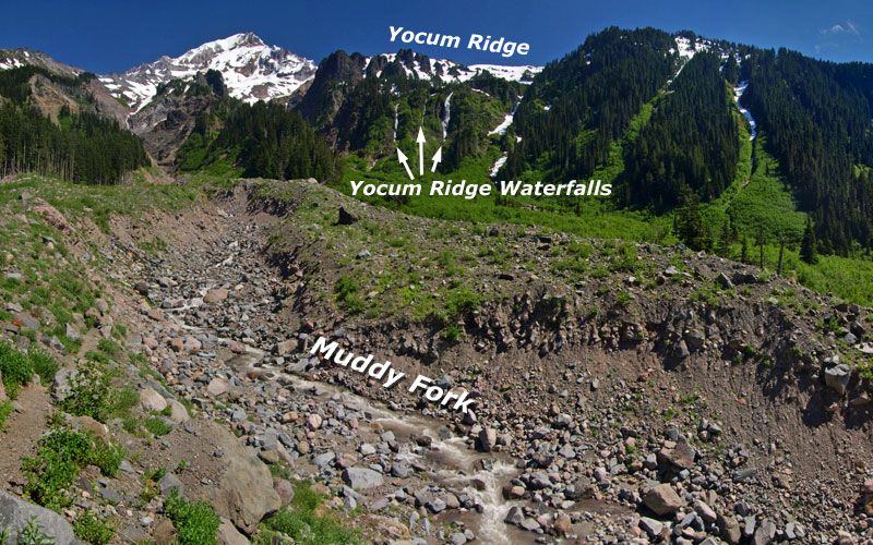
Scores of little-known waterfalls hide in Mount Hood’s backcountry. Some are towering glacial torrents, while others are quiet forest cascades, framed in moss and maple leaves. But when conditions are right, few rival the towering trio of waterfalls that mark peak snowmelt on the upper ramparts of Yocum Ridge.
These waterfalls are unnamed and unmapped, but familiar to hikers crossing the Muddy Fork on the Timberline Trail or visiting McNeil Point, across the canyon. They completely disappear by autumn in dry years, but in early summer, they are Mount Hood’s roaring counterparts to the famous seasonal giants of Yosemite.

(Click here for a larger view)
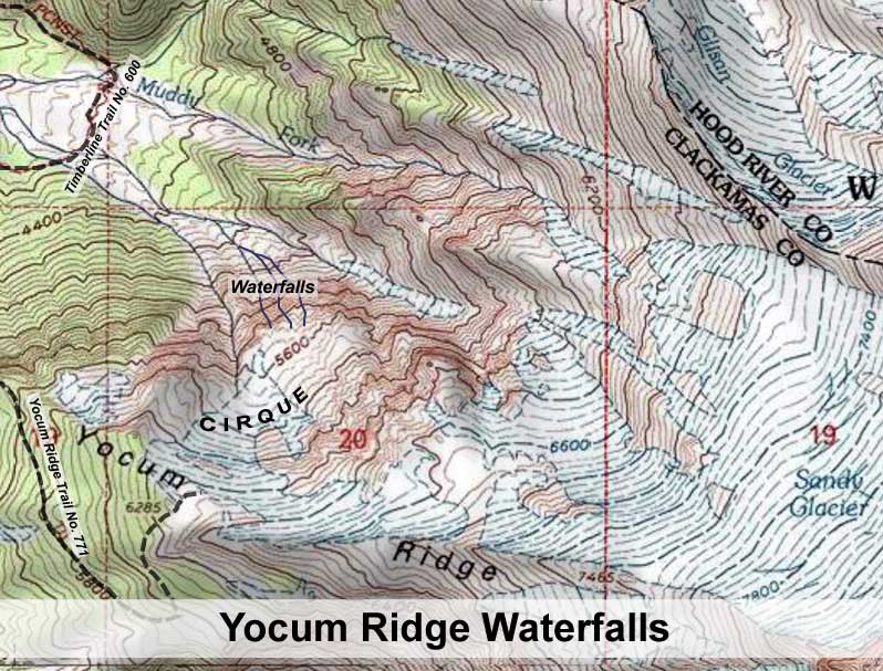
These waterfalls originate from an unnamed glacial cirque, or bowl, high on the northern shoulder of Yocum Ridge, the massive spine that divides the Muddy Fork from the Sandy River, and extends to the summit of Mount Hood. Though they flow from a relatively small basin, the snowfields that accumulate in the cirque each winter generate a surprisingly powerful runoff.
In recent decades, the year-round snowfields in the basin have almost disappeared, compared to 1960s-vintage USGS maps (below). This seems to have opened a more direct snowmelt channel to the waterfalls, as they seem more prominent in recent years, while the perennial stream to the west, as shown on the USGS maps, has become much less prominent.

(Click here for a larger view)
The cirque is well below the tree line, so the lack of forests in this amphitheater is also a good indicator of both heavy snow accumulations and frequent winter avalanches.
The view (below) from across the canyon shows the waterfalls in relation to Yocum Ridge and the cirque. The low ridge to the right of the falls forms a lower cusp of the cirque, and this ridge serves as a dike that channels most of the spring runoff toward the waterfalls. The Yocum Ridge Trail (shown on the map, above) terminates at the rim of the cirque, in the extreme upper right corner of this view:

A closer look at the waterfalls, as viewed from below at the Muddy Fork crossing (below), shows the rugged upper crags of Yocum Ridge in the background, with the waterfalls tumbling from the cirque into the Muddy Fork canyon. The cirque is located to the right, just outside this frame.
Surprisingly, a sizeable forest is perched on the slopes to the left of the waterfalls, apparently spared by the most frequent avalanches that have cleared most of the slopes within the cirque.

(Click here for a larger view)
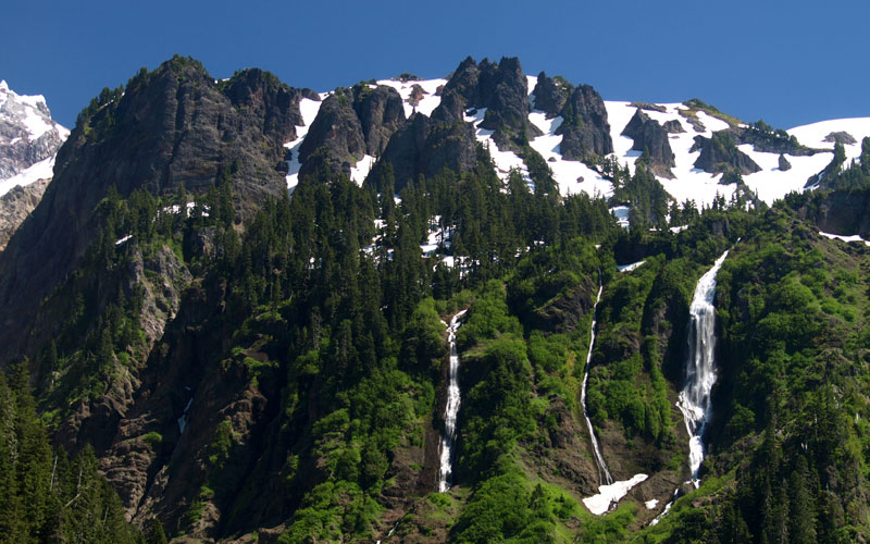
It’s somewhat unknown how the streams that feed these waterfalls originate, since they are not mapped, and perhaps not even explored. However, from Google Earth imagery, the trio of waterfalls seem to flow from three distinct sources, with the western falls draining the main portion of the cirque, and the middle and east segments draining directly off the upper slopes of Yocum Ridge.
A closer view (below) shows the trio of waterfalls in detail. The westernmost of the three (on the right) is by far the largest, dropping at least 700 feet in the main cascade, and arguably nearly 800 overall. This drop is on a scale with Multnomah Falls, which drops a total of 635 feet, by comparison.

The eastern segment (on the left) is next in size, and though dwarfed by its larger sister to the west, is quite large and drops at least 500 feet. The middle segment is a tall, thin slide that is nearly as tall as the western segment, albeit much less dramatic.
 The towering western falls (left) starts out as a 100-foot slide, and quickly fans out for 150 feet before leaping over a wide, 400-foot plunge.
The falls collects in a steep amphitheater at the base of the main plunge before making a final 70-foot plunge into a roiling, narrow gorge.
A closer look at the main plunge of the western falls (below) reveals the raw power at work during peak snowmelt, with its roaring curtains of falling water.
Somehow, thickets of red alder cling to the cliffs around the falls, framing the scene. This spectacle persists for several weeks in early summer, yet nearly disappears in autumn and through the winter.

The following video captures this dramatic scene, as viewed from the Muddy Fork crossing on the Timberline Trail in July 2010:
_________________________________________
How to visit the Waterfalls
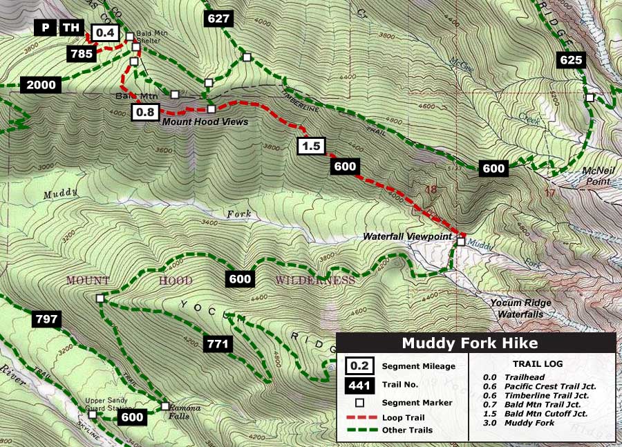
Viewing the Yocum Ridge Waterfalls up close makes for a terrific day hike, and the waterfalls are at their prime as soon as the trails open — usually late June or July. The recommended 5.4 mile (round-trip) hike shown on the map below starts at the usually crowded Top Spur Trailhead, near Lolo Pass. But most of the hikers are heading for McNeil Point, so you will see very few people beyond the series of junctions at Bald Mountain.

(Click here for a larger, printable map)
Starting at Top Spur, the trail climbs somewhat steeply for 0.4 to a signed junction with the Pacific Crest Trail (PCT). Turn right onto the PCT, and immediately reach a confusing 4-way junction with the Timberline Trail. Turn right onto the famed Timberline Trail, heading uphill and to the right, past a sign pointing to the Muddy Fork
The Timberline Trail climbs gently through noble fir forest, soon passing the unmarked junction with the Bald Mountain trail. A short distance beyond, the trail traverses across the steep meadows on the south face of Bald Mountain, with stunning views of Mount Hood and the Muddy Fork canyon.

Mount Hood and the Muddy Fork canyon from Bald Mountain
After re-entering the forest, the trail passes yet another junction, this time with the unsigned Bald Mountain Cutoff. Head straight, going through a log gate before making a very gradual descent to the Muddy Fork.
Once at the Muddy Fork, the trail enters the scene of a violent debris flow that crashed through the area in 2002, snapping thousands of mature trees like match sticks and pouring 20 feet of debris across the valley floor.
The Muddy Fork has made short work of the debris in the subsequent 10 years, cutting all the way down to its former stream level. This makes crossing difficult for Timberline Trail hikers, but that’s okay: the best view of the Yocum Ridge waterfalls is from one of the scores of boulders resting atop the debris flow, where you can relax and take in Mount Hood, the waterfalls and the roaring Muddy Fork, below.
Be sure to bring binoculars and a camera — and enjoy!

A couple things:
1 – I doubt the stream to the west of the falls that the topo maps mark is perennial, since it doesn’t actually originate in the basin which feeds the falls. If you look at the basin on Google Earth (use the June 26, 2005 imagery) you can clearly see that the vast majority of the basin drains into the western falls instead of the gully to the west of the falls, hence the significant volume only in that waterfall. It might have been different when the snowfield was till there, but I don’t even see evidence of drainage patterns which would indicate that water has flowed that direction anytime recently.
2 – I think you’re being way too liberal on the height of the falls. I’d put the big falls at a maximum of about 520 feet, and probably more realistically closer to 460 feet or so. The only way to suggest the drop is 700 feet is to count the talus cascades below the legitimate falling part of the stream.
LikeLike
I agree on the stream to the west, Bryan. It’s hard to know why it was mapped the way it was, though it’s possible that permanent snowfields allowed runoff to overtop the low ridge at the base of the cirque.
As far as height, we’ll I’m drawing that from Google Earth and USGS elevation — let me know when you’ve taken your patented waterfall measuring system down there for a more accurate estimate. But yes, I’m tossing in the full length of the cascade, including the slide at the top.
I do need to go back and edit one part of the article: Google Earth shows clearly defined, separate streams coming off Yocum Ridge for the middle and east segments.
LikeLike
Nice exploration, Tom. Those falls are great. I’ve only seen them the one time that my wife and I did the Timberline Trail back in 2005. Never thought to make a day hike out of it. Great idea!
LikeLike
interesting, I believe I have a photo of the large falls in winter taken last Dec 2011, would not have identified it if I had not browsed this blog. (Same photo has a small 2 tiered falls in the foreground as well), taken from McNeil Ridge
LikeLike