Muddy Fork Debris Flow at 20 Years

20 years later, it’s hard to imagine the massive debris flow that roared down the verdant Muddy Fork valley in 2002…

Earlier this year I posted a “then-and-now” look at the changes to the Cooper Spur area on Mount Hood’s east flank over the past 20 years, including dramatic changes to the Eliot Glacier. This article provides a similar look at forces of nature that have once again reshaped the Muddy Fork canyon, on Mount Hood’s steep western flank. 

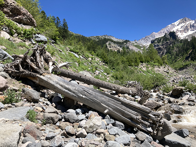
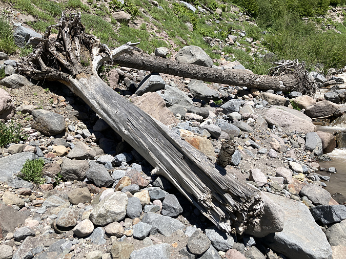
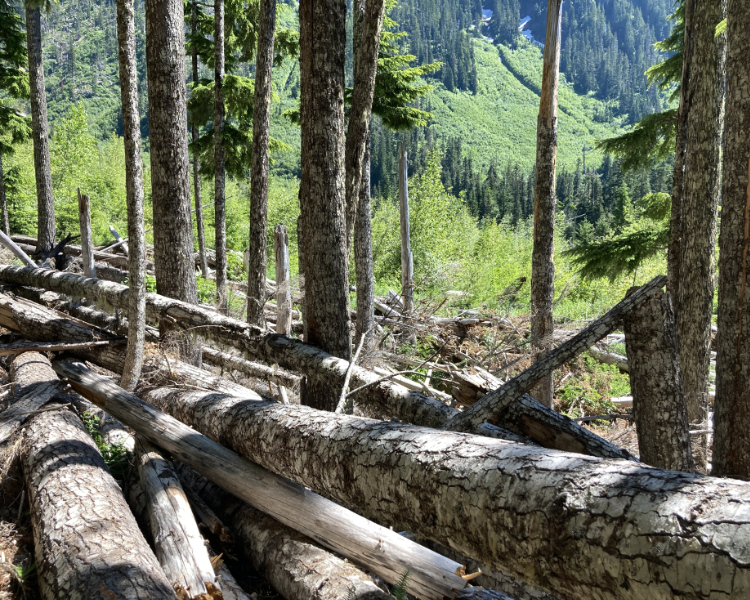
The story begins in the winter of 2002-03 with a massive debris flow triggered by a landslide in the upper Muddy Fork canyon. The event occurred sometime during the winter season, when deep snow-covered hiking trails, and thus went unnoticed until the snowpack cleared that spring. The event immensely powerful, mowing down whole forests and raising the valley floor of the upper Muddy Fork by as much as 20 feet. Whole trees were snapped off and carried downstream with the debris, forming huge piles that still give mute testimony to the power of the event.

Stacks of downed trees still give mute testimony to the violence of the 2002 event

Though the exact origins of the initial landslide remain unknown, the event was probably not triggered by a collapse within the Sandy Glacier that looms above the Muddy Fork, as there were few signs of the debris flow near the glacier, above the section of the upper canyon where the landslide scars were obvious. Instead, the debris flow likely began as a major slope collapse within the steep confines of upper canyon, where the Muddy Fork tumbles between sheer rock cliffs and steep talus slopes. 

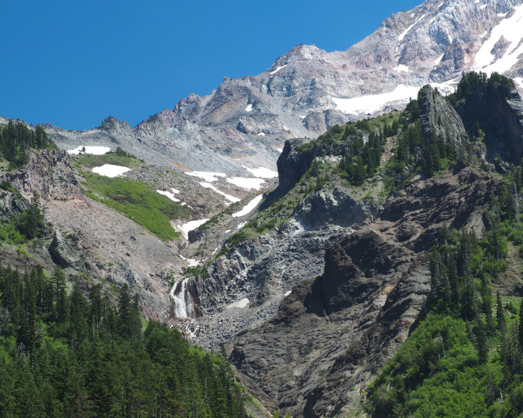
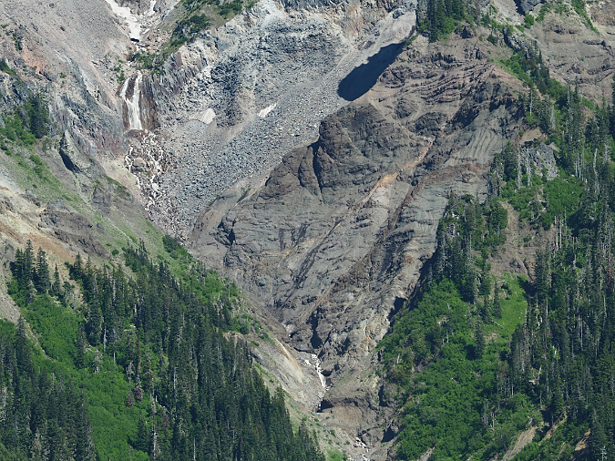
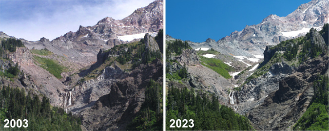
The scars from the 2002 collapse are still plainly visible today (below), but the debris fields it created downstream are rapidly being reclaimed by new forests. The landslide created new cliffs and steep walls within the upper canyon, including new waterfalls along the Muddy Fork where the stream suddenly plunged over the newly exposed bedrock. 

The massive 2002 cliff collapse in the upper reaches of the Muddy Fork canyon gave birth to a debris flow that spread for miles downstream

Below the cliff-lined section of the upper canyon, the debris flow fanned out, spreading the landslide debris across the broad floor of the Muddy Fork valley. Nobody witnessed the event, so it’s unknown exactly how it played out. However, the wide debris fields of rock and sand clearly resulted from a major event, as did the complete removal of a standing forest. 

Trees swept up in the flow were stacked in piles that suggested a lot of water content in the debris flow – as much mud as it was rock – due to saturated winter soils and possibly a sudden snowmelt, perhaps from an unusually mild winter storm.  Whole trees were rafted on their sides until they were beached in giant log jams against forest stands along the valley margins that somehow survived. Evidence of the flow only became apparent when hikers returned that spring to find the Timberline Trail completely erased where it had crossed the Muddy Fork.

The raw cliffs and talus slopes surrounding McNeil Falls are still recovering from the event after 20 years

Over the course of the two decades that have since passed, the Muddy Fork quickly cut through the new debris to reach the old valley floor, revealing splintered stumps from trees that were snapped off during the event, then buried in the debris (below). This has confined the stream to a deep channel in the upper valley that limits its once-meandering ways across the valley floor, at least for now. However, the event only affected the north branch of the Muddy Fork, leaving the south branch almost untouched. 

Large trees by the thousands were snapped off and upended by the debris flow, then buried on the floor of the Muddy Fork valley

The Muddy Fork quickly excavated a new channel in the debris flow, unearthing trees like these that had been buried on their sides under the debris

While the north branch is currently confined to its newly cut channel, this is a temporary condition. Debris flows along Mount Hood’s glacial streams are a nearly constant reality, and even major events like the one that occurred on the Muddy Fork in 2002 are not uncommon. As jarring as these events are to witness, they also give us a privileged glimpse into the very processes that have shaped the mountain we know today. In time, smaller debris flows will gradually choke the current channel with debris, and the Muddy Fork will once again meander across the valley floor – just 20 feet higher than it was in 2002.

The Muddy Fork debris flow then… and now

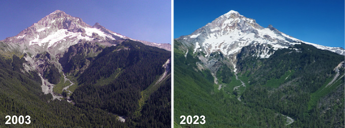
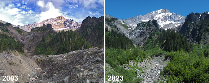
Though it wasn’t apparent to casual visitors from a distance, hikers who knew the mountain immediately spotted the debris flow from the open slopes of Bald Mountain, where the Timberline Trail provides a sweeping view of Mount Hood’s west face. Before the debris flow, the two main branches of the Muddy Fork had similar floodways at the head of the valley, below the Sandy Glacier. As the 2003 image (below, left) shows, the north branch was suddenly much wider. Today, forest recovery has nearly erased signs of the debris field (below, right) from this vantage point.

[click here for a large version of this photo pair]

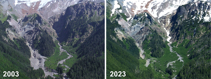
A closer look at this photo comparison reveals the scale of the debris flow in the summer of 2003, shortly after the event (below, left). The debris field was up to 1/4 mile wide and left up to 20 feet of debris in the channel of the north branch of the Muddy Fork. After 20 years (below, right), a carpet of green, recovering forest has already reclaimed much of the new debris field.

[click here for a large version of this photo pair]

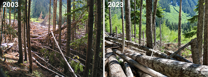
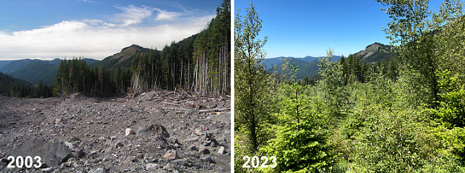
Down at ground zero, the scene at the head of the Muddy Fork valley in 2003 (below, left) was of astonishing destruction. Whole forests were toppled and piled like matchsticks along the margins of the debris flow, pushing into standing forests just high enough on the valley walls to have escaped the waves of debris. 

Twenty years later (below, right), most of the forest debris remains, though new logs were added to the jumble in the September 2020 wind event (described in this WyEast Blog article) that swept over Mount Hood. The new, mostly decidious forest rapidly emerging on the debris flow can also be seen in the 2023 image as the bright green band in the mid-background.

[click here for a large version of this photo pair]

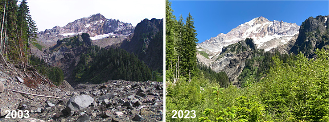
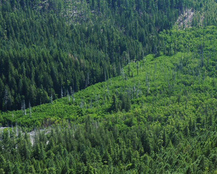
The debris flow was still raw and unstable in the summer of 2003 (below, left), but after 20 years, a dense young forest (below, right) of Red Alder, Cottonwood and scattered Douglas Fir is quickly stabilizing the debris field. The health and vigor of this young forest growing on a 20-foot layer of boulders, gravel and sand is testament to the remarkable fertility of volcanic soils. While this new deposit contains almost new organic matter or true soil, the mineral content is rich in iron, potassium, phosphorus and other mineral nutrients essential to plant growth.  

[click here for a large version of this photo pair]

Red Alder and Cottonwood are no surprise, here. Both are pioneer species known for their ability to colonize disturbed areas – but the presence of Douglas Fir is a surprise (two can be seen in the foreground of the 2023 image). If the young firs growing within this largely deciduous new growth can keep pace with their broadleaf neighbors, the new forest could begin to be dominated with evergreen conifers within a few decades, speeding up the succession process that typically unfolds in a recovering forest.

Looking downstream (west) from the center of the debris field in 2003 (below, left) provided a true perspective on the scale of the event, with large debris deposits mounded against heaps of stacked, toppled trees. After 20 years, the recovery (below, right) is rapidly obscuring the view, though Bald Mountain can still be seen over the young tree tops. The tallest of the young trees in the 2023 view are Cottonwood and most of the smaller tree are Red Alder. The conifer in the foreground is a young Douglas Fir – roughly 15 tears old and about eight feet tall.

[click here for a large version of this photo pair]

Turning back (east) toward the mountain from roughly the same spot, the view in 2003 (below, left) revealed a new channel through the debris that the Muddy Fork had almost immediately begun excavating. By 2023 (below, right) the channel has been widened over the years, though its depth has since stabilized at the old valley floor level. The second photo also shows the new forest quickly hemming the channel in from both sides.

[click here for a large version of this photo pair]

Still, the Muddy Fork is a glacial stream, and therefore volatile. It continues to expand, then refill its new channel with debris from smaller flood events that occur almost every year.

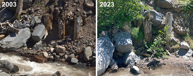
On one of my first visits to the debris field, I spotted a row of tree stumps (below) that marked the original valley floor – or perhaps an ancient valley floor? In this spot, the Muddy Fork had cut down through the loose flow material, exposing these sure markers of a former level of the valley floor. 

One surprise is how quickly the Muddy Fork settled in to its new landscape after the debris flow. As these photos show, the stream quickly cut its way to the former valley floor then mostly stopped cutting any deeper in the many years that followed, despite its famously volatile flow. These stumps – and even the two large boulders to the left – remain today much as they were 20 years ago, despite being directly adjacent to the stream and exposed to the many flood events that occur here.

[click here for a large version of this photo pair]

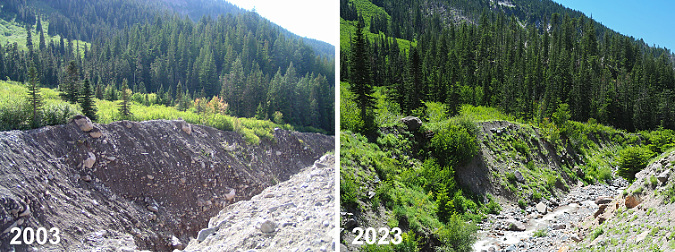
Looking downstream (below) from just above the spot where the stumps were revealed, you can see how little change to the new channel has occurred since it was initially carved in the year after the event. The large boulder on the lip of the channel (left side of these images) is still perched there – and the three Noble fir growing it that survived the original event are still thriving today, nearly twice as tall. 

[click here for a large version of this photo pair]

The most notable difference in the above photo pair is how debris has begun to refill the channel, as evidenced in the 2023 photo on the right. This process will continue over time until the channel has filled and the Muddy Fork is once again meandering across the main valley floor.

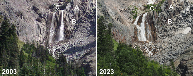
I don’t have good photo records of the narrow, upper canyon of the north branch Muddy Fork from prior to the 2002 debris flow. However, I have seen both photos (and even paintings) of this idyllic scene from the 1980s and 90s that show a waterfall here. Based on those earlier images, I do think that a single waterfall existed before the debris flow, roughly where the new falls is located today. Waterfall hunters have dubbed this “McNeil Falls”, referencing nearby McNeil Point – just off to the right in the photo pair, below.

[click here for a large version of this photo pair]

While the landslide and debris flow that it triggered in 2002 did seem to move McNeil Falls somewhat, the most notable change was to produce a twin waterfall – something waterfall hunters (the author included!) prize. However, as the reshaped falls has continued to evolve over the two decades since the event, the two segments have gradually begun to merge into one – or so I thought until I took a closer look for this article. 

In the following photo pair, you can see that the Muddy Fork has actually been carving away debris from the sloped bedrock, and simply moved the falls northward and down the cliff scarp. You can see the shift by matching the rocks marked “A” on the right, the dark notch to the left of the letter “B” and the protruding rock marked “C” that – surprisingly – used to divide the two tiers of the falls! Today, the south (right) tier of the semi-twin drop is really the original north tier, and a completely new tier has formed to the left of this original tier where landslide debris was cleared from the rock ledge. 

[click here for a large version of this photo pair]

Look closely at the above photo pair and you can also see some very large boulders perched to the left of the falls as they existed in 2003. These have since been eroded away, and contributed to the pile of rock debris that has accumulated at the base of the falls in the 2023 photo –shortening the falls a bit.

What will the future bring for McNeil Falls? My guess is that it will continue to shift north a bit more, likely becoming a single tier – twin waterfalls are rare! But even as it find its way to a lower brink along that cliff scarp, the stream will also gradually move loose rock away from the base of the falls as the canyon walls stabilize, so it might become taller over time. There are other examples of exactly this phenomenon on other big waterfalls around Mount Hood – most notably, Stranahan Falls, on the Eliot Branch, which has gained at least 30 feet in height from an eroding canyon floor at its base. Of course, McNeil Falls will also continue to suffer the brunt of the Muddy Fork’s volatile nature and keep changing and reinventing for centuries (and millennia) to come.

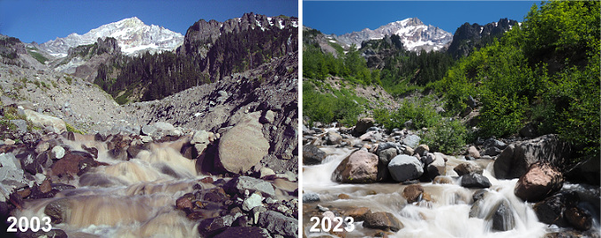
Downstream from the falls, the bed of the Muddy Fork continues to gradually collect new debris as the channel carved in the years immediately after the debris flow continues to fill. This can be seen in the photo pair (below), where large boulders now fill the floor of the new channel – and even support young alder and willow pioneers on small midstream islands.

[click here for a large version of this photo pair]

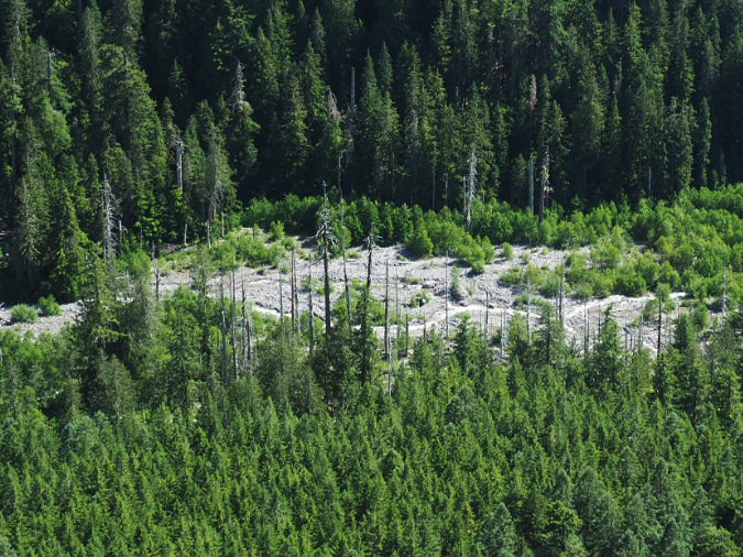
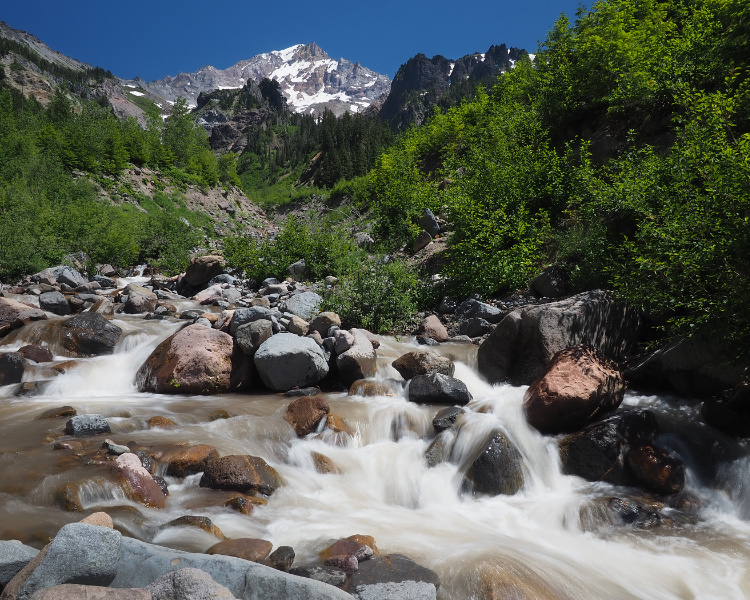
The downstream effects of the 2002 debris flow on the Muddy Fork were less dramatic, yet still reshaped the way the river flows through its valley. This view of the valley (below) from Bald Mountain is roughly two miles below the source of the debris flow. The large rock and gravel deposits along the stream are still plainly visible twenty years later, though the bright green alder and willow colonies have begun to reforest the flooded area. In this view, you can also see the bleached ghost trees along both sides of the stream that were killed by the debris flow. 

Though riparian trees like Sitka alder and willows are making inroads, the Muddy Fork continues to meander across the debris flow where the valley is less steep and the stream less channeled

These disturbed areas now serve as important habitat for raptors and cavity-nesting birds alike, along with many other species that require standing skeleton trees to survive. The dense new riparian growth (below) is equally important to many species that require streamside habitat. While major events like the 2002 debris flow might be shocking for us, it’s also a reminder that violent processes like this are built into the cycle of the ecosystem – they are required for the species who have adapted over millennia to forests that continually cycle through disruption and recovery. 

Large areas of the debris flow have recovered further downstream from the event, marked by the bright green stands of alder, willow and cottonwood along the Muddy Fork in this view from Bald Mountain

Debris flow pioneers

Whether from fire, debris flow or even human-caused events like logging, watching our forests recover and rebuild provides invaluable insight into the role individual species play in the health of forests. Where we used to value our forests mostly for the lumber that could be harvested (and therefore, mostly for big conifers) we now know that non-commercial species like alder, willow and cottonwood are as essential to forest health as the conifers.

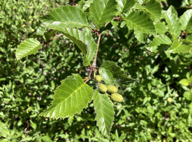
Twenty years into the recovery, I expected to find Sitka alder (below) dominating the young forests returning to the debris flow, as these tough, adaptable trees among the first to reclaim disturbed ground wherever it might occur. They are often called “slide alder” for their ability to survive in avalanche chutes, as they freely bend and give under the heaviest of winter snow loads, often popping new leads from horizontal, snowpack-flattened limbs. But alders have a super-power that is especially important in forest recovery: they are nitrogen fixers that enrich the soil as they grow, making them uniquely suited as pioneers in disturbed areas.

Sitka alder growing on the Muddy Fork debris flow

What I didn’t expect to find in the recovering forest atop the debris flow were Black cottonwood (below). Yet, many are thriving throughout the alder thickets, outpacing the alders since they can easily grow to 50-60 feet in mountain environments compared to just 30-40 feet for alders. Cottonwood are fast growers, too, especially where they can tap into a steady supply of groundwater – something the shallow water table in the Muddy Fork valley provides in abundance. They are important wildlife trees, too, including the browse they provide as young trees and the nesting cavities that form in the trunks of older trees as they mature.

Cottonwood growing on the Muddy Fork debris flow

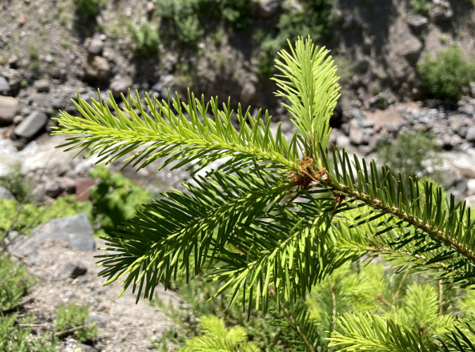
An even more startling pioneer in the recovering forest on the debris flow are Douglas fir (below). These trees don’t require much of an introduction — as our state tree and a species found all over Oregon. I didn’t expect to find so many here, in part because we’ve been conditioned by the timber industry to believe these native conifers must be hand-planted after logging, and then only after all other vegetation that might compete has been killed with herbicides.  

Douglas fir growing on the Muddy Fork debris flow

Douglas fir are fast growers, and with their early arrival as pioneers in the new forests along the Muddy Fork, there’s a good chance they will keep pace with both the alders and cottonwood and quickly begin to restore a conifer overstory – though “quick” is measured in decades and centuries when describing forest recovery! 

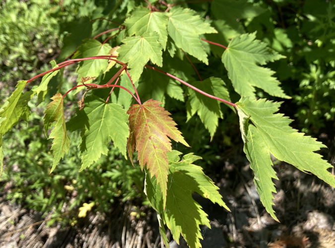
Douglas maple growing on the Muddy Fork debris flow

Another surprise in the new forest growing on the debris flow is Douglas maple (above), a close cousin to our Vine maple, and sometimes called Rocky Mountain maple. These attractive trees are sprinkled throughout the young trees returning to the Muddy Fork and they are positioned to become part of the future understory of a mature conifer stand. Where alder and cottonwood are eventually shaded out by taller conifers, Douglas maple are more tolerant of shade, and can coexist with the big trees. They are also more drought-tolerant than their Vine maple cousins, and thus well-suited to the sandy upper layers of the debris flow that can become quite dry during summer droughts.

The cycle continues… except faster, now

Just as the recent series of wildfires in WyEast country have given us the gift of insight into how a forest regenerates after a burn, the debris flow on the Muddy Fork is providing a glimpse into the resilience of Mount Hood’s forests in the face of growing disturbances from climate-driven floods, landslides and debris flows. There is no way to know if the 2002 landslide in the Muddy Fork canyon was triggered by climate change, yet scientists do know that extreme rain events and unusually saturated soils are increasingly triggering such events. And while these events have always occurred, the extreme and often erratic nature of our storms in recent years has accelerated the pace and scale of flooding and debris-flow events on the mountain. The good news from the Muddy Fork is that our forests are – so far – coping well with these changes, especially in riparian areas where the restored habitat is most critical. 

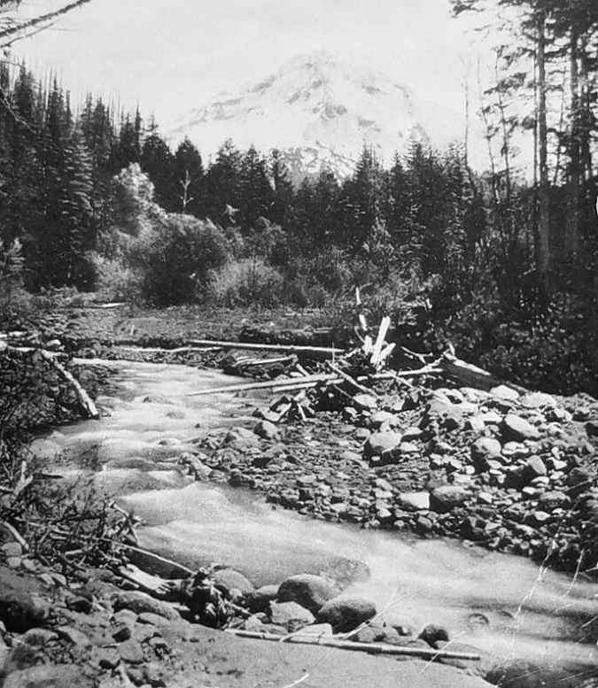
Early 1900s scene along the upper Sandy River

Historic images and geologic evidence show these events to be part of a timeless cycle of destruction and rebirth. This image (above) show the upper Sandy River valley in the early 1900s, with mix of debris and young streamside vegetation (the willows and alders toward the background) that look much like today’s conditions. Clearly, periodic floods and debris flow events had always played a role, here.

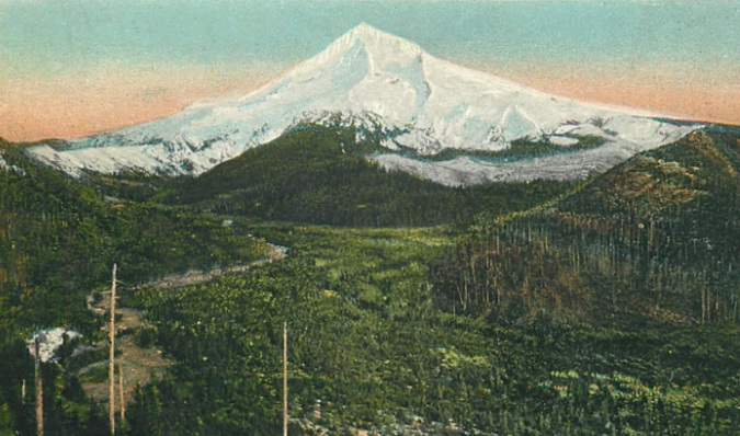
This image (below) is a wider, hand-tinted view from about 1900 that shows the Muddy Fork branch of the Sandy River hugging the left side of the valley, with obvious signs of flooding and debris flows. There’s a story in the young forests covering the balance of the flat Sandy River valley floor, too (known as Old Maid Flat) in this view: at the time the photo was taken, just over a century had elapsed since the Old Maid eruptions on Mount Hood covered this entire valley with a debris flow that extended 50 miles downstream to the Columbia River, creating today’s Sandy River Delta. This very early view also shows burn scars (colorized as white snow) around the western foot of the mountain that have long-since recovered, and are now covered with dense forests of Noble fir.

The Muddy Fork is the open channel on the left in this colorized view of the Sandy River Valley from about 1900

While these events may seem random and jarring in from the perspective of a human lifetime, when you connect the dots between events over geologic time, the continuum is that of a mountain in a perpetual state of both eroding and occasionally rebuilding itself, one catastrophic event after another.

It is this long view that helps us understand and appreciate how our forests have evolved not to a specific end-state (the view from a logging perspective), but instead, have evolved to continually adapt to their conditions in a perpetual state of renewal and rebirth. The fact that our forests are rebounding so readily in places like the Muddy Fork or the scorched slopes of the Gorge fire — even now, in the midst of climate change – is both inspiring and reassuring in a time of unprecedented change in the world around us.
The Big Fir at Shepperd’s Dell

1920s postcard view of the Shepperd’s Dell Bridge and its iconic Douglas fir (colorized for this article)

A reader reached out a few weeks ago with a question about “that big fir tree at Shepperd’s Dell, and as it turned out, I had been working on an article on that very subject! The tree in question is unmistakable: it stands near the east end of the iconic Shepperd’s Dell Bridge, perhaps the most recognizable of the many graceful bridges along the Historic Columbia River Highway.

The big tree is a Douglas fir, Oregon’s official state tree, and it has been growing here since well before this section of the historic highway was constructed in 1914. The tree grows in a protected hollow, surrounded on three sides by basalt cliffs. George Shepperd, the local farmer who donated what is today’s Shepperd’s Dell State Natural Area to become a park, walked under the tree with his family on their regular visits to visit the waterfalls at Shepperd’s Dell from their farm, located just to the east. Today, countless visitors admire it from the shady wayside at the east end of the bridge.

1910s view of the west approach to Shepperd’s Dell with the big fir rising in front of Bishops Cap

Early photos of the new Shepperd’s Dell Bridge taken in the late 1910s (above) show the tree prominently framing the rock outcrop known as Bishops Cap, more than a century ago. At the time, the tree was large enough to easily be 60-70 years old, though it still had the symetrical shape of a relatively youthful tree.

The image below shows the 1910s scene in reverse, from atop Bishops Cap, with the big Douglas fir standing out in the foreground and a few early motorists parked along the opposite side of the highway.

1910s view looking west from the top of Bishops Cap toward Shepperd’s Dell Bridge, with early motorists and the big fir front and center at the east end of the bridge

This hand-colored postcard (below) from the 1930s features Bishops Cap, and the big Douglas fir is especially prominent in this view. The construction of Historic Columbia River Highway was famously designed to blend with nature and follow the contours of the land, but that still required road engineer Samuel Lancaster to do some fairly heavy blasting and grading to complete the scenic route. At Shepperd’s Dell, he graded the slope above the big fir, but clearly took care to protect the tree from fill debris, likely extending its life for another century.

1930s hand-tinted postcard view of Bishops Cap with the big fir prominently featured to the left

Here’s another hand-tinted 1930s postcard view (below) from the west end of the Shepperd’s Dell Bridge showing Bishops Cap and the big fir. When I first came across this image, I assumed that a fair amount of artist’s license was used to create the scene, since it appears to be from a point in space, where a vertical cliff drops directly below the historic highway.

1930s hand-tinted postcard view of the Shepperd’s Dell Bridge and the big fir in the upper left

However, I eventually came across the 1920s era photo (below) that the previous, hand-tinted image was created from. It turns out the photographer was part mountain goat and managed to capture the scene from a vertical slope below the old highway! As in the hand-tinted view, the big Douglas fir rises beyond the bridge, on the left.

This is the 1920s photograph that the previous hand-tinted scene was based upon, with the big fir in the upper left

This 1910s view (below) is perhaps the most popular of the early images of the Shepperd’s Dell Bridge. It appeared in both its black and white original form and in colorized versions on countless postcards and in souvenir folios that were popular with early motorists visiting the Gorge. At the time this photo was taken, many sections of the new highway were still unpaved, including the section at Shepperd’s Dell.

This is perhaps the most popular 1920s postcard view of Shepperd’s Dell Bridge, with the big fir on the left

Over the century since Samuel Lancaster built his iconic highway through the area, the big fir at Shepperd’s Dell has thrived, as shown in this pair of images (below). The arrows provide reference points on Bishops Cap that helps underscore just how much the old fir has grown in just over century when viewed from the same spot at the west end of Shepperd’s Dell Bridge.

A century passed between these views, but the big fir remains and has grown noticeably largerthe 2021 view is somewhat wider than the 1920s view to fully capture the big fir!

[click here for a larger version of this comparison]

In the 1920s view, the top of the big fir was visually just a big higher than the top of Bishops Cap. By 2021, the tree had not only added some 50 feet to its height, it had also spread out and formed a more rounded crown that is typical for mature Douglas fir. The upper arrow in the 2021 image points to what was the approximate top of the tree in the 1920s. The spread of the tree is noticeable in the 2021 image, as well, as it now obscures part of Bishops Cap from this perspective.

The big fir at Shepperd’s Dell after the fire..?

The charred base of the big fir at Shepperd’s Dell in 2018, one year after the fire

Today, the Shepperd’s Dell fir remains a familiar feature to those stopping at the wayside, a true survivor that stands out from the surrounding forest. Its stout trunk is much larger than other trees in the area, and there has always been a bit of a mystery about a plank attached to the tree and metal cable that disappears into the canopy (I won’t attempt to solve that in this article!). So, when Eagle Creek Fire swept through the Gorge and reached Shepperd’s Dell over Labor Day weekend in 2017, the fate of this old tree was on my mind.

In the immediate aftermath of the fire, it was clear that the big tree hadn’t crowned (meaning the fire hadn’t engulfed the entire tree), but a significant part of the crown had been scorched and the bark at the base of the tree was badly blackened. The understory around the tree was completely burned away, so it was clear the fire had burned hot when it swept through. Because the fire occurred toward the end of the growing season, when conifers are becoming dormant with the approach of winter, it was impossible to know if the living cambium layers under the big fir’s thick bark had been destroyed by the heat of the burn. That would have to wait until the next spring, when the stress of producing new growth would test the its ability to survive.

By the fall of 2018 — one year after the fire – the situation was discouraging. The old tree had put out very little new growth on its remaining green limbs in its first growing season after the fire. And while it retained many of its surviving limbs over the course of that year’s summer drought, many had dropped their needles and died back (below), leaving the tree with less than half its canopy intact. Still, it had managed to survive the first year following the fire.

Looking up at the badly scorched canopy of the big fir in 2018, one year after the fire

The group of younger Douglas fir around the big tree didn’t fare as well. Some had been immediately killed by the fire, while others that survived the initial blaze seemed to have lost too much living canopy to recover from the fire (below). During that first summer, the combined loss of green canopy and stress from the annual drought season was too much for many of these trees to survive their first year after the fire.

The scorched big fir and its smaller companions in 2018, one year after the fire

As the big fir at Shepperd’s Dell entered its second winter season after the fire in 2018-19, it wasn’t looking good at all. It has put on almost no new growth that year, and the annual needle drop that fall left even more blackened, bare limbs exposed.

Worse, the Oregon Department of Transportation (ODOT) was cutting down what it deemed to be hazard trees along the historic highway in the wake of the fire. This included scores of trees around Shepperd’s Dell, some of them living trees that were impacted by the fire, but still surviving. Its haggard appearance at the time (below) put the big fir at great risk of being defined a “hazard” by highway crews, but thankfully, it was spared from the chainsaws.

The Shepperd’s Dell fir in 2019… with less than half its canopy intact, the old tree was still hanging on…

Then, in the spring of 2019, the big fir pushed out a modest flush of new growth on its surviving limbs in its second season of growth following the fire. It wasn’t much, but it did signal that the tree was finally starting to rebound from the fire. It was no longer losing ground in its recovery.

As the spring of 2020 unfolded, our world seemed to stop as the COVID pandemic swept the globe, but for the big fir at Shepperd’s Dell, things were clearly looking up. The tree put on another flush of new growth in its third year following the fire, then another flush of new growth followed in the spring of 2021. While we hunkered down in the pandemic, the big fir was making its comeback (below).

The big fir makes a comeback: three growing seasons between these images show significant recovery of the crown and middle canopy

[click here for a larger version of this comparison]

Looking up into the canopy in 2021, the change in just three years of gradual recovery is dramatic (below). The big fir has been rebuilding its living canopy and thereby restoring its ability to actively grow, once again. Surprisingly, some of the new growth was also emerging from limbs that seemed to have been lost in that first year after the fire, but apparently had just enough living cambium layer left to allow new growth to emerge through the blackened bark.

Looking up into the recovering canopy of the big fir in late 2021

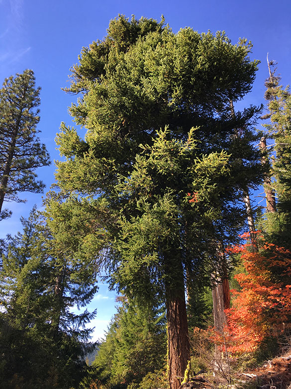
Today, the future of the big fir at Shepperd’s Dell seems much brighter. Its recovery is remarkable, considering how many of its neighbors were lost to the fire (below). But that’s no accident. Our largest conifers — Douglas Fir, Ponderosa Pine and Western Larch — typically drop their lower limbs as they grow. This adaption focuses growth at the top of their canopies, where they can absorb the most sunlight, but it also helps protect their living crowns when fires sweep through by denying a “ladder” of lower limbs that allow fire to climb up the tree to the main canopy.

Low intensity fires reinforce this adaptation, with the lowest limbs of moderately burned trees often succumbing to the fire, even as the tree survives, placing its crown still further above the reach of future moderate intensity burns. These “cool” fires are beneficial, helping thin the forest, remove accumulated fuel, invigorate the leafy understory and allow the largest trees to live on to continue anchoring the forest. Combined with thick, fire-resistant bark, these big conifer species define the “fire forests” along the east slopes of the Cascades, where fire is an essential part of the ecosystem, though Douglas Fir grows throughout the Cascades.

The big fir survives! But some of its companions did not…

While some of the area burned in the 2017 Eagle Creek fire fit the definition of “beneficial”, vast areas burned far too hot for any trees to survive, requiring whole ecosystems to restart from bare soil, and in turn, exposing bare soil to serious erosion. Today, modern forest management is increasingly embracing prescribed burns with moderately hot fires to mimic the frequent beneficial burns that were common before modern fire suppression began in the early 1900s. While still controversial for the risk that prescribed burns can potentially bring to rural property, their overwhelming benefit to the forest and role in preventing catastrophic fires is unquestionable.

Look closely at the burn patterns following the Eagle Creek Fire, and you will also see big conifers growing in moist canyons or shaded north-facing slopes were more likely to survive the fire. This has to do with the timing of the blaze. When the fire swept through over Labor Day weekend in 2017, Oregon’s forests were at their most stressed point in the growing season, with several months of drought and hot weather drying trees out and making their extremely vulnerable to fire.

Yet, trees with better access to moisture during the annual drought cycle are able to stay fully hydrated, and are much less vulnerable to the intense heat of a forest fire. This is also why some of our largest trees are found where summer moisture is available. Look at the bark on many of these trees, and you are likely to see ancient burn marks, often from multiple fires that these trees have survived over their long lives. As our forests cope with a changing, warming climate, these conditions favorable to survival will become increasingly important if we hope to continue to have big trees in our forests.

Aerial view of Shepperd’s Dell from 2019 showing the historic highway curving gracefully around the shaded hollow holding the big fir (ODOT image)

What does the future hold for the big fir at Shepperd’s Dell? In the near future, this old tree suddenly has less competition for water and nutrients from nearby trees that succumbed to the fire. For the longer term, it enjoys an excellent location for survival, growing in a shaded, moist bowl surrounded by protective cliffs that buffer it from the seemingly perpetual Columbia Gorge winds.

Douglas fir can live for centuries, and there’s no reason this old tree can’t outlive every human being walking on the planet today – and their children and grandchildren, too! Its most lethal threat is probably us. So, hopefully we will continue to give it the respect and space to grow that Sam Lancaster provided with his curving highway design more than a century ago, allowing many future generations to marvel at this old survivor, just as we do.


Previous WyEast Blog articles on the remarkable George Shepperd:

The Farmer and his Dell

Heirs to George Shepperd’s Legacy

13 things to know… before you stand under the Mistletoe!

Douglas fir east of Mount Hood engulfed in Dwarf Mistletoe

“Everybody knows a turkey and some mistletoe
Help to make the season bright…”

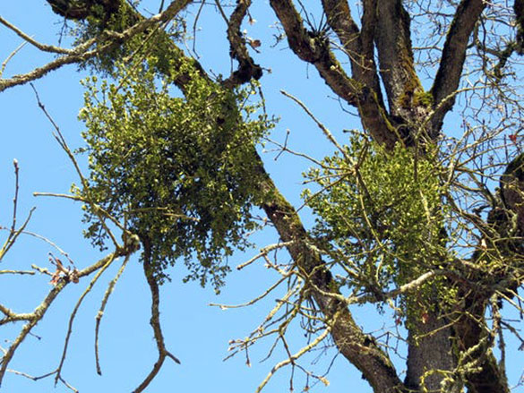
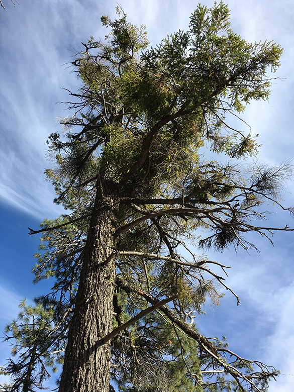
Did you know that we have an unlikely cousin to the holiday mistletoe growing prolifically across Mount Hood country? Unlike the species you’re likely to find hanging over a doorway (known as Leafy mistletoe of the genus Phoradendron) or even from our Willamette Valley white oak stands, this cousin is the lesser known Dwarf mistletoe, of the genus Arceuthobium. And unlike the holiday version, this humble Mistletoe is hard to spot, though signs of its presence in our forests are very obvious. 

Familiar Leafy Mistletoe growing on an Oregon white oak in the Willamette Valley (OSU Extension)

Like their holiday cousins, Dwarf mistletoe are parasitic plants that require a living host to survive, and in our corner of the world their hosts are mostly the big conifers. Dwarf mistletoe grow by extending root-like structures known as “haustoria” into the growing tissue of their host, and producing shoots outside the bark of their host where flowers and fruit form, and where their seeds spread to other hosts. 

Sound a little creepy? Perhaps, given how we humans tend to view parasites. But these plants are also quite fascinating, and historically they have had a bad reputation, thanks to the timber industry and its enduring reluctance to see the forest for more than the saw logs they might produce.

So, here are some things to know (and maybe even love?) about Dwarf mistletoe next time you venture out among these humble parasites:

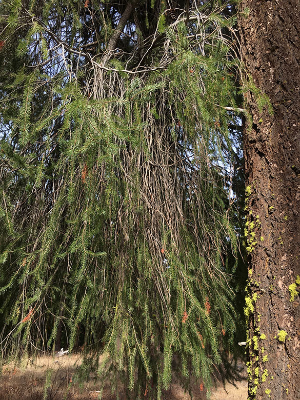
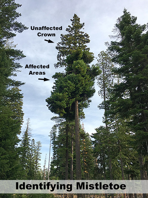
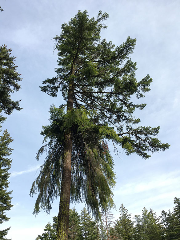
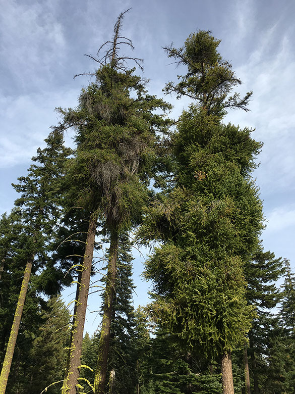
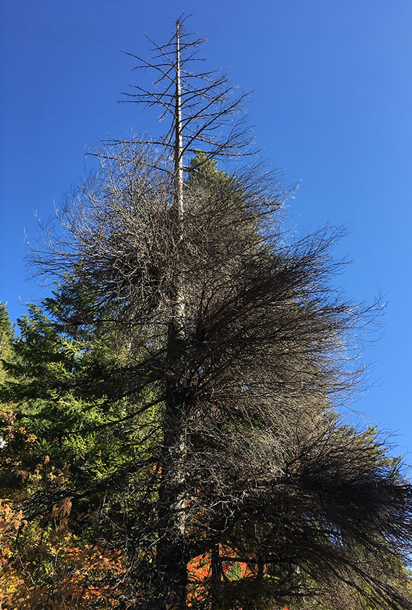
1. They are commonly called Witches Broom.This is self-explanatory, as an infected tree (especially Douglas fir) tends to grow dense masses of branches in response to an infection that can hang down like brooms. This is the easiest way to spot Dwarf mistletoe in the forest.

“Witches broom” on a Douglas fir
Typical Dwarf Mistletoe infection on a Douglas Fir

2. They are gendered.Mistletoes occur in male and female forms, with the male plants producing pollen and the family plants producing fruits and seed. Both the male and female forms can reside in the same host — and a single host can have multiple active Mistletoe infections.

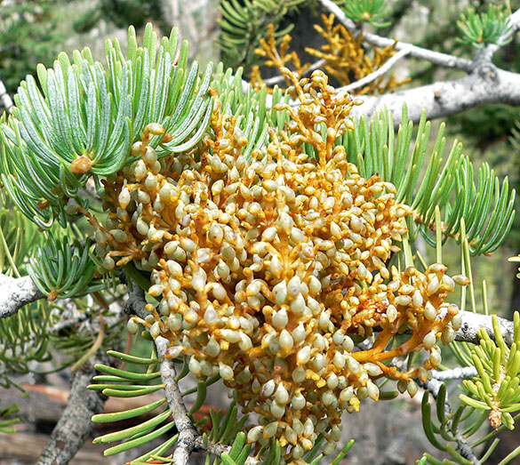
3. Their berries pack some heat!Ripe Mistletoe berries are designed to explode in late summer, shooting seeds as much as 50 feet in the air (!) to land on nearby, potential host trees. Their seeds are sticky and adhere to whatever they land on, and this feature also means that birds and small animals help disperse the seed when they visit host trees with ripe Mistletoe fruit and carry the seeds to other trees on their fur or feathers. While this firepower allows Mistletoe to spread to nearby hosts and to the understory below, it also allows the plant to move upward in its host tree, as much as one foot per year.

Mistletoe fruit emerging from a true fir (Wikimedia)
Dwarf Mistletoe infections gradually moving up toward the healthy part of a large Douglas fir

4. They like their hosts on the softer side. With seeds shooting in all directions at high velocity, Dwarf mistletoe might seem somewhat indiscriminate in their reproduction. But it turns out they are playing the odds, as sprouting seeds usually invade host tissue that is less than five years old. This is why young trees in the understory beneath a large, infected tree are so vulnerable. However, Mistletoe typically does not infect trees younger than 10 years, for reasons yet unknown.

5. They’re early — and prolific — bloomers.For the first couple of years after a Dwarf mistletoe seedling has attached to a new host, the young plant quietly sends its haustoria into the tree’s living tissues, feeding on water and nutrients from the host as the Mistletoe grows. After a couple years, the site of the infection swells and over the next few years the new Mistletoe begins producing aerial shoots, flowering and eventually producing fruit. Within five years, a new Mistletoe plant has gone from seed to what can be many successive cycles of fruiting from a single infected site on a tree.

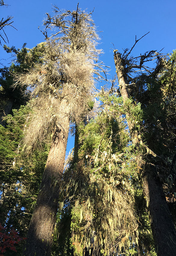
This big Douglas fir is marked by dozens of Dwarf mistletoe infections positioned to spread seeds far and wide in the surrounding forest

6. They like the East side.Dwarf mistletoe species grow throughout Oregon, but in Mount Hood country they are most prolific on the dry east side of the mountain. This isn’t because they have an aversion to wet weather, but instead, because…

7. ….they are host-species specific!There are many species of Dwarf mistletoe, and most specific to just one or two host species, Many of these preferred host species also happen to grow on the east slope of the Cascades. Here are the most common Dwarf mistletoes in Mount Hood Country, most named for their hosts:

• Douglas-fir dwarf mistletoe

• Western larch dwarf mistletoe

• Western dwarf mistletoe (host is Ponderosa pine)

• Lodgepole pine dwarf mistletoe

• Western white pine dwarf mistletoe

• True fir dwarf mistletoe (hosts are White fir and Grand fir)

• Western hemlock dwarf mistletoe (also infects some true firs)

• Mountain hemlock dwarf mistletoe

The effects of these Dwarf mistletoe species on their hosts vary widely. Douglas fir is most affected by its species of Dwarf mistletoe, often producing very large brooms. Western larch can also be heavily affected when their brittle limbs give way to the weight of brooms. By comparison, Hemlocks less than 120 years in age are typically not affected by the infestations and other hosts show very little effect from infections. This is why we’re unlikely to even notice many of the Mistletoe-hosting trees in our forests.

Dwarf mistletoe probably infected the declining tree on the left first, then spread to infected tree on the right that still retains much of its foliage

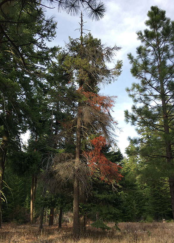
8. They can eventually kill their hosts.Heavily infected trees can eventually lose so much foliage from having their living tissue invaded by multiple Dwarf mistletoe infections that they can no longer survive. This is common among Douglas firs, where its accompanying Mistletoe species significantly disrupts growth and produces very large brooms. But the Mistletoe infestation is often simply the gateway to other invaders that are often more fatal to the host tree. These include bark beetles, rusts and other fungi that invade trees affected by Mistletoe. Heavily affected trees typically die 10-15 years from their first Dwarf mistletoe infection.

This young Douglas fir is slowly dying from its Dwarf mistletoe infection

9. They favor stressed trees.Trees growing in poor soils or affected by drought are more susceptible to infestations. This could be why Douglas fir on the dry east side of the Cascades are more likely to host Dwarf Mistletoe. But this is also an example of the role that this parasite plays in forest succession and, over millennia, the evolution of its host species. By preying on the weakest among their hosts, Mistletoe mimic so many examples in nature where predation on sick or frail helps improve the gene pool of the prey species. 

10. They love fire suppression. We have been learning our lesson from a century of forest fire prevention the hard way in recent years with the string of long-overdue, catastrophic fires that have swept through Mount Hood country. This is especially true on the east side forests, where regular, low intensity fires are an important part of forest healthy. Fire suppression since the 1920s has left us with stressed, unhealthy forests with enormous fuel buildups that will take decades to restore to health. But this is good news if you’re Dwarf mistletoe, as the parasite thrives in these forests, spreading quickly among the stressed hosts.

This recently thinned plantation shows widespread Dwarf mistletoe in the “healthy” trees left standing

11. They love forest plantations. There are so many reasons why mono-culture tree plantations in logged areas of our forests are a bad idea, and susceptibility to Mistletoe infestations is just one more, since these parasites are host-species parasites. This is especially true for Douglas fir plantations, the timber industry favorite, and also a species that is more significantly affected by Mistletoe infections than most other conifers. Dwarf mistletoe can spread especially quickly in these overgrown, same-species plantations.

12. They create valuable habitat! Yes, they are parasites that can kill their host, but Dwarf mistletoe have been part of our forest ecosystem for millennia and are just as natural as the forest itself. The brooms they create high in the crowns of conifers might be unsightly to us, but they provide habitat for birds and small mammals for nesting and feeding, and chipmunks feed on their stems and seeds. Large brooms also provide protected resting sites under infected trees for deer and elk. 

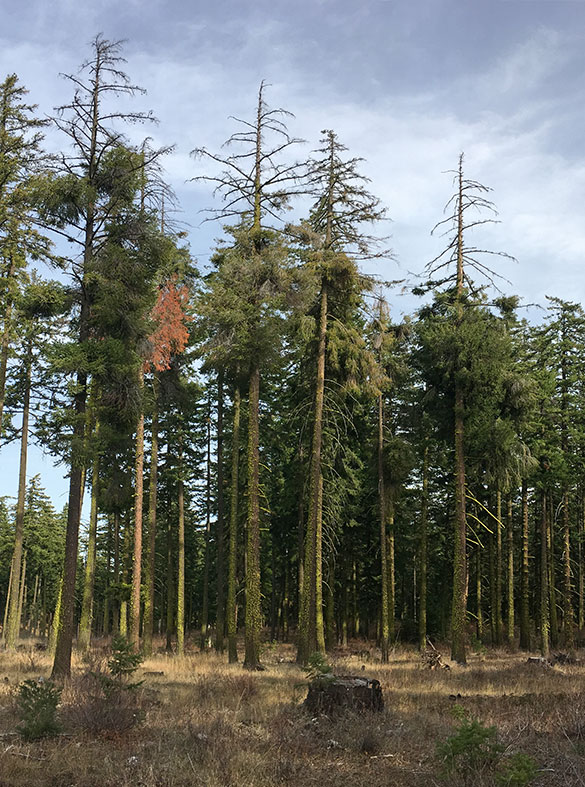
Killed treetops of infected trees also provide perches and nesting sites for raptors and owls. Decayed areas in standing trees resulting from fungi invading Mistletoe-infected sites can serve as essential habitat for cavity-nesting birds and small mammals, too.

Treetops killed by Dwarf mistletoe create roosts for raptors and owls

13. They are good for forests!Really? Yes, because in a healthy, balanced ecosystem, the effect of Dwarf mistletoe in selectively killing trees is beneficial to the forest by creating canopy gaps and standing snags that are known to increase plant and animal diversity. Likewise, healthy, multi-story forests are also less vulnerable to severe Dwarf mistletoe infections, which (of course!) is how this ecological balance has evolved in our forests.

These recently killed Douglas fir will become wildlife trees as snags, and create a healthy opening in this mature forest

That last point underscores that the “solution” to the widespread Mistletoe infections we see in many of today’s east side forests is really to recognize the abundance of Mistletoe as a symptom, not the problem. Restoring today’s stressed, logged-over forests and clear-cut plantations to the mixed conifer stands that once thrived across Mount Hood country is the simplest answer. It’s also the only sustainable answer.

The good news is that the Forest Service is gradually moving in this direction with gradual plantation thinning starting to take hold in the Mount Hood area and even the occasional use of fire as a management tool in other parts of Oregon. Not everyone agrees with plantation thinning, but so far, the results appear to support continuing this practice, at least until the most overgrown plantations have been thinned to a semblance of a natural forest.

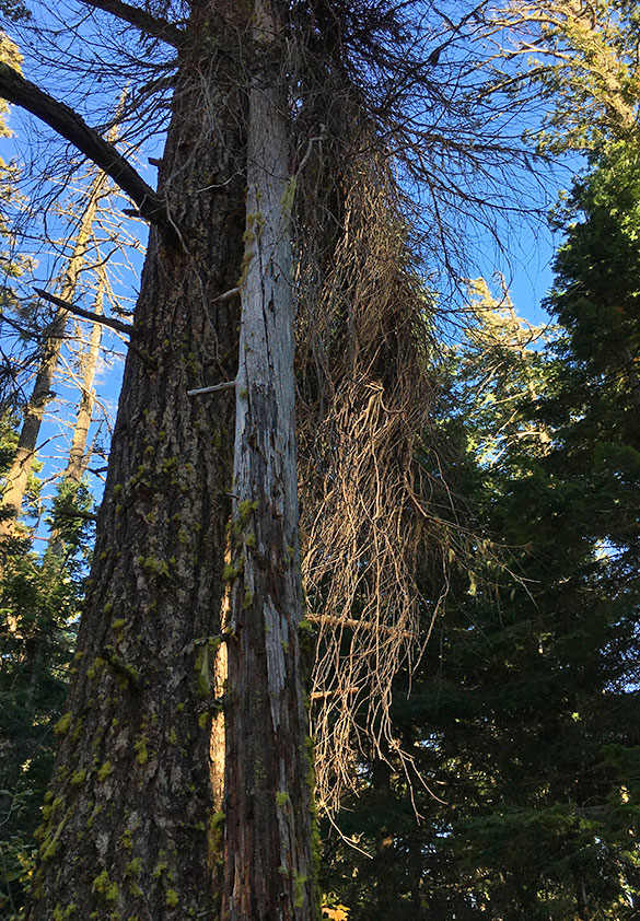
Dead witches broom skeleton cascades down a large (and still living) Douglas fir near Mount Hood

Unfortunately, the current Forest Plan guiding these decisions for Mount Hood is nearly 30 years old, and the plantation thinning being done under this plan is not being done with a vision or bringing natural forests back, but rather, to simply prepare the remaining forest for more timber harvests. 

This is yet another reason why a new plan and long-term vision of forest health is desperately needed for Mount Hood, one that centers on sustainable uses like recreation, native fish recovery and clean drinking water for our growing region, not just meeting timber harvest quotas. I’m confident that we’re gradually moving in that direction, if very slowly.

In the meantime, take a second look next time you’re out in the forest to appreciate this lesser-known parasite… when you find yourself standing under the Mistletoe!