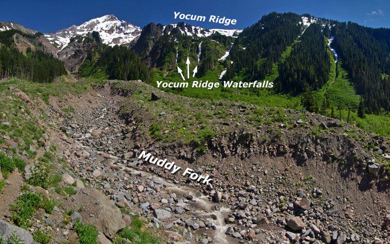
After the Dollar Lake Fire

The Dollar Lake Fire from Bald Butte on September 3, 2011

On August 26, 2011, a lightning strike ignited what was to become the Dollar Lake Fire, on Mount Hood’s rugged north side. The fire started in the Coe Branch canyon, just below the Elk Cove trail, and was spotted by numerous hikers.

Initially, it seemed small and manageable. But over the next few days and weeks, arid conditions and strong winds spread the fire from Stranahan Ridge on the east to Cathedral Ridge on the northwest side of the mountain, eventually consuming some 6,300 acres of high elevation forest. The blaze burned through September and into early October, when fall rains finally arrived.

Hot spot erupts along Stranahan Ridge on September 3, 2011

Some of the burn was of the beneficial form, a mosaic fire leaving islands of surviving trees, but much of the fire was too hot and the accumulated forest fuel too plentiful to prevent devastating crown fires from sweeping across the forest. Eventually, the fire destroyed most of the standing timber and burned the forest duff down to mineral soil throughout most of the burn area.

The fire was contained entirely within the Mount Hood Wilderness, thanks to the recent Clear Branch additions that expanded the wilderness boundary on the north to encompass the Clear Branch valley and the high country surrounding Owl Point, to the north. While this complicated fire fighting, it has also created a living laboratory for forest recovery, as the USFS is unlikely to assist the reforestation process inside the wilderness boundary. The Forest Service map, below, shows the broad extent of the fire.

Final extent of the Dollar Lake Fire (outlined in red)

Though the fire burned to the tree line in several spots, a surprising amount of terrain along the iconic Timberline Trail was somehow spared. While the burn touched Elk Cove and Cairn Basin, WyEast Basin and Barrett Spur are well beyond the burned area. The Clear Branch wilderness additions to the north were mostly spared, as well.

The New Vista Ridge: After the Fire

The following is a photo essay from my first visit to the burn, on June 22, 2012, and is the first in what will eventually be a series of articles on the aftermath of the fire.

The devastation left by the fire is awesome to witness, but also starkly beautiful when you consider the context of a forest fire. After all, this event is part of the natural rhythm of the forest just as much as the changing of seasons.

From this point forward, we will have a front-row seat to the miracle of life returning to the fire zone, much as we’ve watched life return to the Mount St. Helens blast zone over the past 32 years. And as my photos show, the rebirth of the forest ecosystem has already begun on Mount Hood’s northern slopes.

Untouched trailhead at Vista Ridge.

From the Vista Ridge trailhead, I followed the Vista Ridge Trail to the snow line, above about 5,000 feet. The Vista Ridge trailhead is completely untouched, though the fire swept through a vast area immediately to the south. Yet, no sign of the fire is evident at the trailhead marker (above).

A bit further up the trail, at the Old Vista Ridge trailhead, the fire zone comes into view. Where green forests existed last summer, browned foliage and a burned forest floor spread out east of the junction. This fringe of the fire is of the healthy “mosaic” form, sparing large trees, while clearing accumulated forest debris.

Old Vista Ridge trailhead spared by fire… just barely.

An unexpected benefit of the fire came last fall, when the USFS added the long-neglected Old Vista Ridge trail to official agency fire maps (below) released to the public. Volunteers began restoring this beautiful trail in 2007, but formal acknowledgement of the route on USFS maps is a welcome development.

Welcome development: Old Vista Ridge trail reappears on USFS fire fighting maps

Clearly, the restoration of the Old Vista Ridge trail helped fire fighters reach this area, and could have served as a fire line had the blaze swept north, across the Clear Branch. Hopefully this is an indication that the Old Vista Ridge trail will someday reappear on the USFS maintenance schedule, too.

Turning south on the Vista Ridge trail from the Old Vista Ridge junction, the wilderness registration box and map board seem to have received divine intervention from the fire — the blaze burned within a few feet of the signs, yet spared both. From here, the Vista Ridge trail abruptly leaves the scorched fringe of the fire, and heads into the most devastated areas.

Vista Ridge trail signs were spared… by divine guidance?

A few yards up the Vista Ridge trail, the devastation quickly intensifies.

From about the 4,700 foot level, the Dollar Lake Fire burned the forests along Vista Ridge to bare earth. In this area, the entire forest crowned, leaving only a scattering of surviving trees where protected by topography or sheer luck. Forest understory, woody debris and duff burned to mineral soil, leaving a slick, muddy surface of ash. For those who have hiked through the previous Bluegrass Fire or Gnarl Fire zones on the east slopes of Mount Hood, this eerie scene is familiar.

The surprisingly intact trail curves through the devastated forests along Vista Ridge.

Crown fires have killed almost all of the standing forests along Vista Ridge.

Amid the devastation in this hottest part of the Dollar Lake Fire, signs of life are already emerging. At this elevation, one of the toughest survivors is beargrass, a member of the lily family with a deep rhizome that allows plants to survive even the hottest fires. These plants are normally evergreen, but were completely scorched in the fire. The new grown in this photo (below) has emerged this spring.

Beargrass (Xerophyllum tenax) emerges from underground rhizomes protected from the fire.

Another surprise is avalanche lily, one of the more delicate flowers in the subalpine ecosystem. Like beargrass, these plants survive thanks to a bulb located deep enough in the soil to escape the heat of the fire. As one of the early bloomers in the mountain forests, these plants area already forming bright green carpets in the sea of fire devastation (below).

Avalanche Lily (Erythronium grandiflorum) emerging from the ashes.

A ribbon of green, these Avalanche Lilies are emerging along the Vista Ridge trail.

Another of the beneficial aspects of the fire comes into view a bit further up the trail: several sections of Vista Ridge had long been overgrown with thickets of overcrowded, stressed trees that were ripe for a burn.

Over the coming years, these areas are likely to evolve into beargrass and huckleberry meadows like those found at nearby Owl Point or along Zigzag Mountain, where fires have opened the landscape to sun-loving, early succession plants.

Unhealthy forest thickets cleared by fire — a beneficial outcome of the blaze.

One human artifact was uncovered by firefighters — a coil of what must be telephone cable (below). This is a first along the Vista Ridge trail, but makes sense given the insulators and cable found along the Old Vista Ridge trail.

It’s hard to know what this connected to, but on the north end, it served the old Perry Lake Guard Station and lookout, just east of Owl Point. It’s possible this line extended to the Bald Mountain lookout, though I have been unable to verify this on historic forest maps.

Telephone cable on Vista Ridge – gathered up and coiled by firefighters?

Though much of the devastation zone still consists of blackened trees and soil, some of the burned forest has begun to evolve into the uniquely attractive second phase. This happens when scorched bark peels away from trees to reveal the often beautiful, unburned wood beneath.

Soon, all of the trees in this forest will shed their bark. The skeletons of thousands of trees will emerge in colors of red, yellow and tan, then gradually fade to a bleached gray and white with time.

The burned trees of Vista Ridge are just beginning to shed their blackened bark, revealing beautiful trunks unscarred by the fire.

Mount Hood rises behind the new ghost forests of Vista Ridge

This second phase of the fire is helped along by winter snow. As the scene above shows, the freeze-thaw and compacting effects of the snow pack have already stripped many trees of their bark beneath the now-melted snowpack. Hot summer sun will continue this process, shrinking the remaining bark until it drops from the drying tree trunk.

This process of de-barking is the first in a post-fire sequence of events that will recycle much-needed organic matter to the forest floor. Twigs and tree limbs will soon fall, and over time, whole trees will begin to drop. This is a critical phase in stabilizing the forest soil, when low vegetation is still just beginning to re-establish in the fire zone.

Strips of tree bark are the first organic layer to accumulate on the floor of the burn zone.

The next few images show the extent of the Dollar Lake Fire, as viewed from Vista Ridge. To the east (below), The Pinnacle was mostly burned, but the fire somehow missed stand of trees just below the north summit.

These trees will play an important role in reforestation of the area, partly because so few trees survived the fire, but also because of their geographic location above the surrounding forest, where wind will widely scatter their seeds.

The Pinnacle, where a small grove of of trees on the north slope survived the fire.

To the south, the area above Elk Cove known as 99 Ridge (shown below) was partly spared, though the fire did scorch the east slopes of the ridge. From this side (to the west), the Timberline Trail corridor was almost completely spared. Ironically, Dollar Lake — the namesake for the fire — appears to have been spared, as well.

To the west of 99 Ridge, WyEast Basin was also spared, but the area along the Timberline Trail to the west of the basin, along the upper sections of Vista Ridge, was largely burned.

Forests along 99 Ridge were spared by the fire.

This panoramic view (below) encompasses the entire mid-section of the fire, from Stranahan Ridge on the horizon to Vista Ridge, on the right. This is a new viewpoint along a largely unnoticed rocky scarp on the east shoulder of Vista Ridge, now revealed thanks to the fire.

(Click here for a much larger panoramic view]

A Changed Landscape

Those who have explored Mount Hood’s north slopes over the years will surely mourn the loss of the beautiful forests of noble fir and mountain hemlock that once stood here — I certainly have. But this is also a chance to watch the ecosystem recover and restore itself over time, as it has for centuries. Among the surprising benefits are the new scenic vistas that are suddenly available, giving a bit more meaning to the name “Vista Ridge.”

The new views from Vista Ridge include Laurance Lake and Bald Butte, to the east.

By following the true ridge top of Vista Ridge, the new views extend east across Laurance Lake and the Clear Branch valley to Bald Butte and the Columbia Basin (above). Most of the area below the ridge is not burned, and this new perspective on the recent additions to the Mount Hood Wilderness is both unexpected and beautiful.

To the north, the new views include the rugged and little-known Owl Point area of the expanded Mount Hood Wilderness (reached by the Old Vista Ridge trail). Mount Adams rises in the distance, above the talus fields and meadows of Owl Point.

Owl Point and Mount Adams from newly revealed viewpoint on Vista Ridge.

This suddenly very scenic “true” ridge along the lower portion of Vista Ridge is easy enough to hike by simply following the ridge top where the existing trail heads into a narrow draw, about one-half mile from the Old Vista Ridge trail junction. It’s worth the visit if you’d like to inspect the scenery and Dollar Lake Fire up-close.

But in the spirit of recasting the Vista Ridge trail in the aftermath of the fire, and taking in these new views, now would be the perfect time to simply realign the trail along the ridge top. As shown on the map (below), this project could be done in a weekend by volunteers, if approved by the Forest Service.

(Click here for a larger map]

The fire has already done the heavy work of trail building by clearing the ground to mineral soil: designing and completing a realigned trail here would be quite straightforward. The slope of the ridge top, itself, is surprisingly gentle and would allow for an easy grade, similar to the current trail.

I hope to pitch this idea to the Forest Service, so if you’re interested in getting involved, watch the Portland Hikers forum for updates. That’s where volunteer work parties will be organized if there is interest from the USFS.

Until then, take the time to explore the fire zone, and watch the unfolding forest recovery firsthand. Visit the Portland Hikers Field Guide for directions to the Vista Ridge Trailhead.

Proposal: Waucoma Bicycle Backcountry

It’s no secret that mountain bikes have been relegated to second-class status when it comes to recreation trails. They’re not allowed in designated wilderness areas, and even with the special set-asides for mountain bikes called out in the recent Mount Hood Wilderness additions, the trail options around the mountain are limited.

It’s also true that bikes and hikers don’t always mix well. Since I’m both a hiker and cyclist, I’m probably more comfortable than most hikers when it comes to shared trails. I love to hike and bike the Surveyor’s Ridge Trail, for example, but most hikers shy away because of its popularity among mountain bikers.

The view toward Mount Hood from Blowdown Mountain

This article is a proposal for something a little different for mountain bikers: the concept is to convert fading logging roads in a scenic area directly adjacent to the Mark O. Hatfield Wilderness to become a dedicated bicycle backcountry. In addition to providing an exciting set of mountain biking trails, the concept would specifically allow for bikepacking — overnight camping at a several destinations that would be bike-in, only.

Most importantly, this new destination would be close to both Portland and the mountain biking hub of Hood River, where bicycle tourism has become an important part of the recreation economy.

[click here for a large, printable map]

The best part of this proposal is that it wouldn’t take much to put the network together. Converting fading roads and constructing just 2.9 miles of new trail (shown in yellow on the map, above) would create a 25-mile bike network of bike-only trails (shown in blue) in an area with terrific scenery, creating as close to a wilderness experience as you can have while on two wheels.

The Proposal

The proposed bicycle backcountry would straddle the high country along Waucoma Ridge, about ten miles due north of Mount Hood. Two main trailheads would serve the backcountry: a new trailhead would be constructed in the headwaters valley of Divers Creek, serving as the primary entry into the bicycle backcountry. The existing Wahtum Lake trailhead would serve as overflow. Both are accessed on paved roads. A third, more remote trailhead would be located at the headwaters of Green Point Creek, accessed by a primitive road.

The view toward Indian Mountain from Waucoma Ridge

Trails

The proposed network has three kinds of bicycle facilities: converted logging roads (dashed blue on the map) functioning as single or dual track routes, new single track bike trails (dashed yellow) and striped bikeways (solid blue) on a short segment of paved Wahtum Lake Road that serves as a critical connection in the proposed network.

The focus of the network is on bicycle loop tours. From the proposed new trailhead, dozens of tour variations are possible, thanks to the dense network of old roads in this area, and the potential to connect and convert them. One out-and-back trail exists, following the Waucoma Road to Indian Mountain (under this proposal, the road would be gated to motor vehicles at the Wahtum Lake trailhead)

Washington’s big volcanoes fill the skyline on the slopes of Indian Mountain

The main focus of the new trail system would be Blowdown Mountain, a surprisingly rugged shield volcano whose gentle summit ridge belies a rugged east face, featuring a craggy volcanic plug rising above a series of forested glacial cirques. An attractive spur road traverses the entire summit ridge of Blowdown Mountain, and would form the spine of the trail network in this part of the bicycle backcountry.

Three small lakes are located in glacial cirques on the northeast flank of the mountain, and views from the high ridges include nearby Mount Hood, to the south, and the high peaks of the Hatfield Wilderness, to the north. The big Washington State volcanoes complete the scene on the northern skyline.

Spring wildflowers line the rustic route Indianhead Ridge with Mount Hood in the distance

The western part of the proposed network focuses on Indianhead Ridge, another high shoulder of the Waucoma Ridge complex, extending south toward the West Fork Hood River. The proposed trail network in this section would include extensive ridge top rides, with panoramic views of Mount Hood and the steep east face of Indian Mountain.

This part of the bicycle backcountry would also encompass the Waucoma Ridge Road, gating and converting the route to bike-only use except for Forest Service vehicles. The road leads through exceptionally scenic terrain, including the former lookout site on Indian Mountain, and fine views into the Eagle Creek valley, within the Hatfield Wilderness. The road, itself, forms the Hatfield Wilderness boundary.

Beautiful Scout Lake in the proposed Waucoma bicycle backcountry

This section of the proposal network also includes seldom-visited Scout Lake, a beautiful forest lake that has historically been stocked with brook trout by the Oregon Department of Fish and Wildlife (ODFW).

Campsites

Five bikepacking campsites are proposed along the new trail circuit. One is simply the existing Indian Springs Campground, an excellent but largely forgotten primitive campground in need of repair. New campsites would be located at Ottertail Lake, the Talus Pond near Gray Butte, Mosquito Lake and Scout Lake, with each offering 5-15 tent sites.

Unlike the nearby Hatfield Wilderness, bikepacking campsites in the new backcountry would feature rustic picnic tables, fire rings and secure hitching racks for bicycles — features that aren’t allowed in a wilderness area, but would be welcome additions in the bicycle backcountry.

Mosquito Lake basin from Blowdown Mountain, with Mt. Defiance and Mt. Adams in the distance

What would it take?

The viability of this proposal is in its simplicity: less than three miles of new trail would open a 25-mile network, with dozens of loop options that could be tailored to the ability of individual mountain bikers. Most of the work required could be done with the help of volunteers, from trail building and campsite development to signage and ongoing maintenance. Some heavy equipment would be required to develop the new, main trailhead and decommission vehicle access to converted roads.

The view across Ottertail Lake basin toward Tomlike Mountain and Mt. St. Helens

Of course, the proposal would also require the Mount Hood National Forest (MHNF) to fully devote the Waucoma Ridge area to quiet recreation. A few years ago, that would have been unlikely, but in recent years, the agency has not only adopted plans to phase out hundreds of miles of logging roads, but also a policy to focus OHV use in a few, very specific areas of the forest. The recent developments could move this proposal into the realm of the possible if sufficient support exists for a bicycle backcountry.

It would take dedicated support from the mountain biking community to make the case to the Forest Service, ideally in a partnership with the agency that would include volunteer support in developing the trail system.

Cyclist on the new Sandy Ridge trail system, an example of collaboration between the USFS and bicycle advocates (City of Sandy)

The good news is that mountain bicycling organizations are already working hard to develop trails elsewhere in the Mount Hood region (such as the Sandy Ridge trail complex, pictured above) and hopefully would find this proposal worth pursuing. If you’re a mountain biker, you can do your part by forwarding this article to like-minded enthusiasts, or your favorite mountain biking organization. It’s a great project just looking for a champion!
____________

Bikepacking Resources

Bikepacking.net is an online community that focuses on off-road touring, away from cars, with great information on gear, routes and trip planning.

The Adventure Cycling Association posted this helpful article on how to pack for your bikepack trip.

Another good article on what to pack for your bikepack on the WhileOutRiding.com blog.

The International Mountain Bicycling Association is the premier organization and advocate for backcountry bicycling.

In the Mount Hood region, the Northwest Trail Alliance is the IMBA Chapter doing the heavy-lifting on bicycle trail advocacy.

Starvation Creek Loop Hike

Cabin Creek Falls

This blog has featured a series of articles on restoration of the former (and future!) Warren Falls, located in the Starvation Creek area. But there is a lot more to see in this interesting and less-traveled corner of the Columbia River Gorge, and this loop hike explores an amazing variety of scenery on a short, but demanding circuit.

Along this way, you’ll see four waterfalls, one “dormant” waterfall, ford two creeks, visit hanging meadows, peer over the brink of some truly breathtaking cliffs and enjoy expansive views of the Columbia River Gorge. You’ll want to print the large version of the trail map, below, as the trail network in the area is dense, and trail signage unreliable.

[click here for a larger, printable trail map]

The hike is best done from late April through early November, as the conditions can be somewhat treacherous in icy winter conditions, and the stream fords difficult in winter and early spring. But for adventurous hikers, this loop is generally open year-round, and provides a nice hiking option when snow covers the high country.

Hiker’s grim warning on a temporary sign at the Starvation Ridge Cutoff Trail..!

Note that the loop described here follows a specific direction, tackling the very steep Starvation Ridge Cutoff Trail first, in the uphill direction. This might seem counter-intuitive, but the steepness of this path is much harder on your knees going down than on your lungs and legs going up — and it can feel a bit slick and sketchy to descend, due to the steepness and exposure.

The Hike

The trail begins at the Starvation Creek Trailhead (directions at the end of this article). Head west from the parking area, walking parallel to the freeway exit, then drop into the trees following a section of the old Columbia River Highway. ODOT will soon be restoring this section of highway as part of a state recreation trail, so watch for construction to begin soon.

The welcome signpost marking the top of the Starvation Ridge Cutoff Trail

A short distance from the trailhead, you’ll see a signboard on the left marking the Starvation Ridge Cutoff Trail No. 414B (if you reach Cabin Creek Falls, you’ve gone too far). Take a deep breath, and begin the stiff climb up this trail, as it threads its way in a series of switchbacks through the towering cliffs that frame the Starvation Creek area.

Soon, the trail curves into the upper canyon of Cabin Creek, leaving the sounds of the freeway behind, and continuing steeply above the creek into dense forest until you reach the signpost marking the upper junction with the Starvation Ridge Trial No. 414.

The dizzying view of the trailhead from the top of the Cutoff Trail

The main loop heads to the right (west), and crosses Cabin Creek. But before you continue in that direction, make a brief detour to the left (east), following the Starvation Ridge Trail uphill for about 200 yards to a spectacular cliff-top viewpoint, a few feet off the trail. From here, you can peer a dizzying 500 vertical feet down to the trailhead and the tiny cars, trucks and freight trains moving below.

Looking west toward Shellrock Mountain and Wind Mountain from the Cabin Creek viewpoint

After resting your legs (and lungs) from the Starvation Cutoff trail, and enjoying the sweeping view from the overlook, retrace your steps back to the junction, and continue west on Trail 414, fording Cabin Creek. From here, the route climbs from the Cabin Creek canyon in a series of short, well-graded switchbacks, and passes another towering cliff-top viewpoint on the right.

The trail soon crests a divide marked by a 1930s-vintage transmission tower, and descends into Warren Creek canyon in a series of switchbacks traversing an enormous hanging meadow. In late April and May, the meadow features beautiful displays of shooting star and other wildflowers, but offers stunning views any time of year.

Shooting Star in the hanging meadow above Warren Creek

Great Hounds Tongue near Cabin Creek

Soon, the trail re-enters forest, then reaches Warren Creek, a potentially difficult ford in winter and early spring. There’s no bridge here, so cross carefully. Warren Creek is the stream that once flowed over Warren Falls, just downstream from the ford. Since 1939 it has been diverted through an odd bypass tunnel that now forms manmade “Hole-in-the-Wall Falls”. You’ll pass both later on the hike.

From Warren Creek, the trail makes a gentle traverse along the forested canyon wall, then turns and crests another ridge below a second transmission tower, before descending across another open area with terrific views of the Columbia River Gorge.

The trail passes this mossy, cliff-top rock garden near Warren Creek

The view west from the Warren Creek viewpoint

The trail now descends to a 3-way junction of the Starvation Ridge (No. 414) and Mount Defiance (No. 413) trails, poorly marked with a very old signpost. From here, the loop hike continues to the right, turning steeply downhill. But first, go straight 200 yards to beautiful Lancaster Falls on Wonder Creek. This magnificent waterfall is named for Samuel Lancaster, the visionary engineer who designed the Historic Columbia River Highway.

Lower, trailside tier of Lancaster Falls

The best trailside view of Lancaster Falls is from the west bank, so be sure to rock-hop your way across. From there, you can also see part of the tall, lacy main tier of this beautiful waterfall (if you’re feeling really adventurous, it’s possible to scramble to a close-up view of the upper tier by heading uphill from the trail, just east of Wonder Creek).

After cooling off at Lancaster Falls, backtrack to the 3-way junction, and rejoin on the Starvation Ridge Trail No. 414, heading left as it descends steeply across an open slope, soon reaching a sturdy, new footbridge over Warren Creek.

Part of the magnificent main tier of Lancaster Trails, located off-trail

You’ll have views of man-made Hole-in-the-Wall Falls from the bridge, but waterfall lovers should take a few minutes to follow the obvious boot path that parallels the dry streambed to the left of the falls.

This streambed leads to the original, natural location of Warren Creek Falls — the topic of several articles on this blog. The hauntingly quiet amphitheater of the original falls is eerie, and it’s easy to imagine the sound and spectacle that once existed when Warren Creek poured over this cascade. During the periods of heavy winter runoff, Warren Creek occasionally overtops the diversion tunnel, and briefly flows down its natural falls. If you look closely, you’ll see evidence of winter storm events that have briefly brought the original falls and streambed back to life.

Warren Falls flowing in one of its rare winter appearances in March 2012

After taking in the scene at the former Warren Falls, retrace your steps on the boot path to the footbridge and turn right, continuing along the main trail for your return to the trailhead (note: the restored Historic Columbia River Highway and trail will soon be constructed in this area, with a new trailhead for the Starvation Ridge Trail relocated to this spot).

The route briefly passes an open area, and then re-enters forest. Watch for old, stone foundations covered in ivy in this area — you’re passing turn-of-the-century homesteads lost to time. Sharp-eyed hikers will also spot a pair of enormous anthills, each measuring six feet in height. A bit further, and you’ll also pass dome-shaped stone bake ovens, possibly built in the early 1900s by highway workers (see the map below for help in finding these traces of human history in the Warren Falls area).

[click here for a larger, printable map]

Finally, the trail rejoins the abandoned section of the old highway, following it to lovely Cabin Creek Falls. Photographers should take a moment to walk the short boot path to the base of the falls to capture the exceptionally beautiful scene. Crane your neck upward, and you will see the huge cliffs to the left of the falls that you skirted above on the Starvation Ridge Cutoff Trail!

To complete your journey, continue along the old highway grade back to the trailhead. A great way to end this hike is with a final stop at magnificent Starvation Creek Falls, the star attraction in this part of the Gorge. To reach the falls, head past the restrooms, and take the spur trail on the right. A string of streamside picnic tables make this an idyllic spot to relax after your hike, and enjoy a picnic lunch.

Misty base of Starvation Creek Falls

Hike Logistics

The usual Columbia River Gorge precautions apply on this hike: you’ll find poison oak, ticks and sheer cliffs, so it’s not a great choice for kids. If you’re bringing small kids on this hike, consider just hiking the lower portion to Lancaster Falls, where they will have plenty to enjoy without steep trails or dangerous exposure.

The steepness of the hike makes it a good candidate for cool weather, too. Hiking poles are especially helpful, and dogs should be leashed on this trail.

Getting there

The trailhead is at the Starvation Creek rest area, located at Exit 55 on I-84, about an hour east of Portland. The trailhead has water and restrooms, and no trailhead permit is required. The Starvation Creek exit is eastbound-only, so to return to Portland, you’ll need to drive another mile east to the Viento State Park exit, then follow the signs west to Portland.

For information on the Historic Columbia River Highway restoration project, check out the ODOT website, and click on “ongoing projects” for construction updates:

Historic Columbia River Highway Project

Visit Restore Warren Falls! on Facebook for more information on the project.

10 Common Poison Oak Myths

Spring in the Columbia River Gorge brings lush greens and a rainbow of wildflowers, but in this heavenly mix you will also find Toxicodendron diversilobum: Western poison oak.

If humans were as immune to the toxic oils of this plant as deer seem to be (they snack on the stuff!), we would simply admire it for the handsome foliage, and maybe even grow it in our gardens. After all, poison oak is an undeniably handsome plant… from a distance.

But instead, humans are prone to contact dermatitis when we encounter poison oak up-close, breaking out in itchy, blistering rashes that can take weeks to subside. Folklore on the cause and remedies for poison oak rash abound, and much of the information in this age of the internet is decidedly misleading.

Handsome devil: poison oak is as toxic as it is elegant.

Here are 10 common myths about poison oak — debunked — with information every hiker should know about this pesky plant:

Myth 1 – Many people are simply immune. I have hiked the poison oak-lined trails of the Columbia Gorge since the age of five, and thus have a 45-year streak of never reacting to it, despite some epic encounters. Am I immune? Maybe, but it turns out only about one-in-ten seem to have no reaction poison oak. Most of us who think we are immune have simply been careful enough — and lucky. If you have a perfect track record, assume it’s your reward for due caution, not immunity.

Myth 2 – Only the sap is toxic. Some believe it takes breaking a stem or crushing the leaves to release the toxic component of poison oak, a chemical called “urushiol” (pronounced “yoo-ROO-she-all”), and that simply brushing against it cannot transmit the toxin to your skin. In fact, urushiol is present throughout the plant, including the surface oils on the leaves and green stems of poision oak. This is especially true in spring, when new foliage literally glistens with toxic oils.

Poison oak usually looks like this in the Gorge: a spreading groundcover, 1-3 feet deep, and favoring open woods and forest margins.

Myth 3 – You’ll know you’ve got it by the next morning. While it takes only about 30 minutes for urushiol to penetrate your skin, the itchy, blistering skin reaction does not appear immediately. For most people, the symptoms are delayed at least 12 hours after exposure, and it usually takes up to 3 days for symptoms to appear — confounding hikers who think they’ve escaped a close encounter without consequence. For a first time sufferer, it generally takes even longer for the rash to appear – as much as 7 to 10 days!

Myth 4 – It takes a lot of exposure to cause a reaction. Poison oak is surprisingly toxic, and only a small amount of exposure can trigger a reaction. A single drop of urushiol on your skin contains more than enough toxin to cause a reaction, and a small amount is easily spread across your skin by perspiration or physical contact while you hike.

Myth 5 – Scratching will spread your rash. Scratching or rubbing a poison oak rash won’t make it spread to other parts of your body, assuming you’ve already washed thoroughly with soap and water. You can spread the rash if urushiol oil is still on your skin, of course. Scratching can lead to secondary skin infections, however, making your itchy misery a bit worse.

Poison oak is versatile, growing as a ground cover, shrub, or as a towering vine, as in this nightmarish scene along the McCord Creek trail.

Myth 6 – Breaking blisters will spread the rash. Breaking blisters won’t spread poison oak to other parts of your body, or other people. But open blisters can become infected and you may cause permanent scarring in the process. In very extreme cases, excessive fluid may need to be withdrawn by a doctor, though in most cases it’s best to simply let blisters heal on their own.

Myth 7 – Dead or leafless plants aren’t toxic. The bare winter stems of poison oak may look harmless, but still contain toxins. Urushiol oil has lasting power, and can stay active on any surface, including dead plants, for up to 5 years. Burning dead or dormant poison oak branches is an especially dangerous practice, as urushiol oils released in smoke can produce disastrous results, if inhaled.

Myth 8 – Dogs can’t get poison oak. Dogs are mostly protected from poison oak by their fur, though some can develop symptoms on their nose or underbelly. But all dogs can accumulate the oils on their fur, and transmit it to unwitting owners. This is especially true for off-leash dogs that might find a lush patch of poison oak just off the trail, but unseen by the dog’s owner.

The safest practice is to simply keep dogs on a leash when in poison oak country, so you know where they’ve been. Even better, give them a shampoo after the trip, as a precaution — or consider leaving Fido behind when you know you’re going to be in prolific poison oak country.

Poison oak growing in shrub form along the Rowena Plateau trail, showing the handsome bronze color of emerging leaves in spring — when the plant is especially toxic.

Myth 9 – You can develop immunity from exposure. False. With some 90% of humans allergic to urushiol, it’s only a matter of time before most of us will develop a reaction, and it turns out the more reactions you experience from exposure to urushiol, the more likely you are to react to with further exposure. But the reverse is also true: avoiding exposure (and outbreaks) reduces your susceptibility to a reaction. In other words, the myth has it backward: your best immunity comes from simply avoiding contact to begin with.

Sadly, the “develop your immunity” myth is among the more dangerous notions circulating on the internet, with countless testimonials on the “homeopathic” benefits of actually eating poison oak leaves in order to develop immunity. This is an incredibly foolhardy, dangerous idea that can lead to serious, life-threatening situations. Don’t even think about it!

Myth 10 – It’s just a rash. For most of us, this is true. But given the delayed (and varied) symptoms, poison oak reaction should always be taken seriously. As with any immune response to toxins, the symptoms can sometimes spiral out of control and become deadly. If you have a serious reaction, you need to see a doctor right away. Here are the American Academy of Dermatology guidelines for knowing if you’re having serious reaction:

• You should see a doctor if swelling persists, specially swelling that makes an eye swell shut or your face to swell.

• You should see a doctor if the rash covers a large part of your body, you have large blisters, or cannot sleep.

• If you have trouble breathing or swallowing, immediately go to an emergency room.

So, you’ve developed a rash from poison oak exposure, and it isn’t serious? Then you can treat it yourself. You can try one of these online resources for tips on managing your itchy journey ahead:

American Academy of Dermatology

Mayo Clinic

There are dozens of resources on the giving medical advice on treating poison oak rash, many with undocumented, anecdotal suggestions, so the best bet is to stick with these, or similarly respected clinical sources.

This impressive poison oak patch in the Viento area shows all three forms of the plant: groundcover, shrub and as a vine, climbing up the tree trunks.

Managing your Poison Oak exposure

The following hiking tips are adapted from recommendations by the American Academy of Dermatology and Mayo Clinic:

During your hike in poison oak country:

• If you are very sensitive, or heading into a lot of poison oak, consider one of the topical skin products containing bentoquatam, a non-prescription compound shown to protect the skin from absorbing urushiol.

• Wear long pants, long sleeves, boots, and gloves. Even when you apply a skin barrier that contains bentoquatam, you still need to cover your skin with clothing.

• Use hiking poles. They have the effect of keeping your hands up and in front of you, where you’re less likely to brush against poison oak.

• Keep your hands and arms away from your face.

• Rinse your skin right away with lukewarm water if you think you’ve been exposed. You may be able to rinse off the oil before the urushiol penetrates your skin.

Another view of an impressive patch of poison oak in the Viento area, growing in open Douglas fir forest.

After your hike in poison oak country:

• Take a shower — not a bath — with plenty of soap and lather.

• Wash all of the clothes you were wearing when you came into contact with poison oak with conventional laundry soap, set for two rinse cycles (if possible).

• Wash or wipe anything that may have urushiol oil on its surface with soap, including hiking poles, leashes, and your pet.

• Some hikers swear by Tecnu, an over-the-counter topical treatment for removing urushiol oils. Clinical tests show it to be somewhat more effective than plain soap, though neither a substitute for avoiding contact to begin with.

Learning to Recognize Poison Oak

Poison oak is easy to recognize: the old adage “leaves of three, let it be” applies, as poison oak generally has three leaflets per stem. With a bit of practice, you can learn to instantly recognize it as you hike, including the leafless stems in winter.

Here’s a close-up of the classic leaf shape (below), somewhat resembling an oak leaf, but with less pronounced lobes. In autumn, poison oak leaves take on striking hues of red and coral before dropping, leaving bare stems in winter. Note the tiny blossoms in the background — in summer, these will become clusters of greenish-white or tan berries.

Poison oak leaf detail: “Leaves of three, let it be..!”

Poison oak has several friends that it often grows with, and these plants can sometimes be confused with the real thing. They’re worth learning to identify, too, partly to know if you’ve been exposed to the real thing — but also because when you see these companion plants, you’re likely to be in poison oak habitat, and can keep an eye out for the genuine article.

One obvious example of a look-alike is the Oregon white oak (below), a classic companion of poison oak, and easily confused where brushy thickets of white oak grow in the eastern Columbia Gorge. Oak leaves are single, however, and usually larger with much deeper lobes than poison oak.

Oregon white oak can be confused with poison oak in the oak savannah country of the eastern Columbia River Gorge (courtesy PCC)

Another companion plant that is somewhat less common, but matches the “leaves of three” identifier is wild blackberry, or bramble (below). These plants are easily identified by their thorny, rambling stems that creep through the forest, small thorns on the underside of the leaves, and edible (and tasty) blackberries that form in summer.

Wild blackberry, or bramble, has “leaflets of three”, but is thorny, not smooth.

Still another companion plant that can be confused with poison oak is ocean spray, which prefers the same open woodland and forest margin habitat that poison oak enjoys. However, its leaves are single, and generally smaller than poison oak.

Ocean spray grows in dense clumps of arching stems, often reaching 8-10 feet in height. The name comes from “sprays” of hundreds of tiny, white blossoms in large clusters that cover plants in summer.

The leaves of ocean spray might initially look like poison oak, but are single and grow from a tall, arching thicket and have dramatic clusters of tiny white blossoms that give the plant its name.

Finally, snowberry is a companion plant of poison oak that normally has small, oval leaves, but in early spring grows larger, lobed leaves that can resemble poison oak at first glance. Snowberry can be identified by its thin, twiggy stems and white, inedible berries that give the plant its name. Most of its leaves are oval, and finely toothed, not lobed.

Early spring leaves on new growth are often exaggerated on snowberry, and can sometimes look like poison oak. The white berries on this plant distinguish it from the poison oak, and give the plant its name. In this view, the more typical oval leaves can bee seen in the background.

Where is Poison Oak Country?

Where can you expect to encounter poison oak? The answer is anywhere you might hike in the Gorge below an elevation of about 2,000 feet. It grows along most low-elevation trails throughout the Gorge, from Angels Rest on the west end to Dalles Mountain Ranch on the east.

Though the most prolific displays are east of Cascade Locks, you will find also lush bowers of poison oak draped over the rustic stone walls at Wahkeena Falls and Multnomah Falls, and along many sections of the popular Eagle Creek Trail (for Clackamas River hikers, it also grows in the lower canyon, under similar conditions).

Poison oak in early spring: new growth emerges in beautiful shades of copper, crimson and gold… though best appreciated from a distance!

The best bet is to assume its presence whenever hiking in the Gorge, and follow the simple precautions described in this article. It doesn’t have to ruin your hike: learning to recognize poison oak in its various forms is peace of mind, as you’ll be able to watch for it and manage your exposure with the knowledge that you know what you’re watching for.

Finally, if you’ve got small kids, there is no better way to teach them about plants than to start with identifying (and not touching!) poison oak. Print these photos of the plant (shown earlier in this article) for them to fold up and carry in a plastic sandwich bag on your next family hike:

(click here for a general view of poison oak)

(click here for a detailed view of the leaves)

It’s a great opportunity to teach young hikers to understand and respect nature, not fear it — and that goes for us grown-up hikers, too!

“Warren Falls, we’re ready for your close-up…”

On May 12, Oregon Public Broadcasting’s popular Oregon Field Guide program travelled to the site of Warren Falls to film a story on the unique history of Warren Creek: the odd 1939 highway department project that silenced the falls, and the potential for restoring the falls to its former grandeur.

Michael Bendixen and Vince Patton on the chilly January trip to Warren Falls

This was the second trip to Warren Falls for Oregon Field Guide producer Vince Patton and videographer Michael Bendixen. Both had joined me for a first look at the area on a particularly icy January day last winter when the Gorge was at its worst — freezing rain and sleet over a crusty layer of snow.

Our May 12 trip would prove to be the welcome opposite: unseasonably warm, summerlike conditions, with trails lined with ferns and wildflowers instead of snow. Along for the trip were PortlandHikers.org friends Adam Sawyer and Jamie Chabot, and Kristen Stallman and Andy Johnson, representing the ODOT team that is steering the Historic Columbia River Highway restoration project.

(from left) Adam, me, Andy, Jamie, Kristen, Vince and Michael at the trailhead

We met at the Starvation Creek trailhead at 9 AM, and loaded up our packs with OPB gear before making the short hike to Warren Falls. Along the way, the OPB team shot a few trail scenes, but were interested in getting to Warren Falls and Hole-in-the-Wall Falls while the morning light lasted.

Vince and Michael working at the mighty basalt wall formed by Warren Falls

We soon reached the massive amphitheater created by Warren Falls, where the OPB crew filmed the haunting scene of the silenced waterfall, marked only by the trail of moss that marks where the waterfall once flowed. The group spent some time here discussing the strange project that diverted Warren Creek in 1939, and the mechanics of the diversion tunnel and accompany flume that has long since disappeared.

Warren Creek had overflowed Warren Falls several times over the course of our wet winter, and there were obvious signs that a large amount of water had coursed down the old streambed. But on this day, the stream was dry, with the eerie quiet that now exists here.

Michael filming at Hole-in-the-Wall Falls

We backtracked to Hole-in-the-Wall Falls for another session of shooting. Here, the rest of the group visited while Michael and Vince captured several angles of the odd, accidental waterfall.

Adam, Andy, Jamie & Kristen at Hole-in-the-Wall Falls

For a good look at the bypass tunnel that creates Hole-in-the-Wall Falls, we moved to the knoll above the footbridge. From this spot, it’s easy to imagine the wood flume that once attached to the tunnel exit and carried Warren Creek over the old highway and railroad, all the way to the Columbia River. Only when the old flume disappeared was today’s man-made falls created.

Pointing out the man-made features of the upper portion of Hole-in-the-Wall Falls

A wood flume originally connected to the tunnel opening, carrying Warren Creek over the old highway and to the Columbia

Next, we hiked up the Starvation Ridge Trail, heading for the brink of Warren Falls, and the huge steel weir at the head of the diversion tunnel.

The original plan was to scramble down Warren Creek from the Starvation Ridge Trail ford for the quarter mile of bushwhacking required to reach the brink of the falls. But Kristen had been to the diversion structure a few days earlier with an ODOT engineering crew, and they had found a faint boot path that dropped more directly from the Starvation Ridge Trail.

We voted on the two options at the Starvation Creek ford: wet feet and a rock hop along the stream or pushing through a hillside of poison oak along the boot path? The poison oak option won the day!

Weighing the alternative routes at the upper Warren Creek crossing

We backtracked to the jump-off point for the boot path, descended through a manageable patch of poison oak, and soon found ourselves curving around a steep, grassy bluff hanging directly above the 120-foot cliffs of Warren Falls.

From here, a dramatic view of the massive Warren Creek diversion structure suddenly came into view, and the OPB crew set up to shoot the scene.

Rounding the approach to the brink of Warren Falls

Michael shoots the diversion structure from the cliff top above Warren Falls

The diversion structure is much larger up-close than the historic drawings or a glimpse from below the falls would suggest. The tilted weir is made from sixty 20-foot steel beams laid across a 28-foot wide trench carved into the cliff. Beneath the mesh of steel rails, the trench leads directly to the bypass tunnel.

A close-up view reveals at least half the weir to be filled with loose rubble, to the extent that it is lush with a strange hanging garden of wildflowers, A thicket of willow has even become established in the upper right corner of the weir, suspended 15 feet above the diversion tunnel, below. The forces of nature are taking back Warren Creek Falls, slowly but surely.

Vince takes in the huge steel weir that covers the diversion tunnel opening, rushing directly below him

The up-close view also shows most of the beams to be twisted and buckled with the ravages of time, thanks to rocks and debris getting lodged between the beams, and the effects of freeze-thaw cycles in the harsh Gorge winters.

Still, the overall structure represents an amazing ingenuity of design and construction detail to have lasted 73 years, but is still functioning as intended. While nature is clearly winning this battle, the persistence of the diversion project is silent tribute to the designers and builders who created these structures in 1939.

Jamie exploring the steel weir from below — the top of Warren Falls is few feet beyond

Jamie peers through the weir into the opening of the diversion tunnel, directly below

Vince found an opening in the upper corner of the weir, and set up a compact camera mounted on a short arm to film the scene below

The OBP team used a compact video camera mounted on an arm to shoot under the weir. Vince found an opening at the upper west corner of the weir that gave access to the view from below the steel beams.

From this angle, Vince was shooting just below the upper edge of the weir, where a 15-foot rubble and masonry dam was constructed across the creek to elevate the angle of the weir structure toward Warren Falls. For 73 years, this design has allowed for loose debris to roll off the weir and over the natural falls, while filtering the waters of Warren Creek through the weir into the bypass tunnel that now forms Hole-in-the-Wall Falls.

Vince filming the tunnel below the weir with the compact camera

Next, we moved to the top of the weir, crossing to the upper east corner of the structure. The view from the top of the weir looking over the brink of Warren Falls is impressive, as is the view toward the Columbia River. From here, Dog Mountain fills the horizon across the river.

But the fact that the river can clearly be seen from the brink makes a good case that Warren Falls was one of the “four cascades caused by small streams falling from the mountainsides” in Captain William Clark’s journal entry of October 29, 1805. The other three were presumably the nearby falls on Starvation Creek, Cabin Creek and Lancaster Falls on Wonder Creek.

Looking down Warren Falls from the top of the weir

Dog Mountain dominates the view from the top of the Warren Creek diversion dam

The view from the top of the weir shows more wear and tear on the structure: the mortared lip of the rubble dam is badly weathered, fully exposing the ends of many of the 60 steel beams that connect to it, with only a rusty bolt anchoring them to the masonry wall.

Here, the decay of the diversion system seems to be moving close to structural failure — another argument for an orderly removal of the weir, and restoration of Warren Falls before it becomes impossible to safely do so.

Close-up of the top of the weir shows the wear-and-tear of 70 years

Vince and Michael planning the shoot from the top of the Warren Falls diversion dam

Jamie helps Michael set up at the top of the diversion structure

The group settled in for a lengthy shoot at the top of the falls, where Michael and Vince worked to capture the setting, and the rest of the group enjoyed the sylvan scene along Warren Creek.

Michael shooting from midstream, at the brink…

Michael posing for a certain Oregon Field Guide fan!

It’s a long drop: Michael shooting from the top of the diversion

The OPB crew wrapped up the day’s shooting with a few interviews and reflections of the group on the diversion project, and the future of Warren Falls. We soon packed up the video gear, and started up the canyon slope for the trail.

Adam shooting the OPB crew… shooting Warren Falls…

On the trip back to the trailhead, we ran into several groups of curious hikers, all familiar with Oregon Field Guide and excited to meet the crew.

One young woman asked what we were filming, and I explained the story to her — and asked her to go to Restore Warren Falls! on Facebook. Later, she approached me at the trailhead, and asked “Why are you focusing on this when there are so many global issues facing the world?”

Jamie muggles the geocache at Warren Falls. We signed it “Oregon Field Guide”

At the time I was somewhat startled, and replied that the project to restore the Historic Columbia River Highway provided a unique opportunity for funding the restoration of Warren Falls — a good argument, and one she seemed to accept. But I wish I’d simply said “We have to start somewhere, and right now, this is as good a place as any!”

“I wondered why somebody didn’t do something. Then I realized, I am somebody.”

~Author Unknown

(Special thanks to the Vince, Michael, Jamie, Adam, Andy and especially Kristen for another great day imagining the past and future Warren Falls)

___________________________

Previous articles on restoring Warren Falls:

Restoring Warren Falls
Warren Falls Lives! (temporarily, at least)
Warren Falls Mystery… Solved!
Warren Falls Solutions
Warren Falls Lives… Again?

Restore Warren Falls! on Facebook

Exploring Mitchell Point

Looking west into the Gorge from Mitchell Point.

If you find yourself overwhelmed by the crowds at Angels Rest, Mitchell Point in the east end of the Gorge is terrific alternative that offers equally stunning views, without the circus atmosphere.

Though the hike is just 2.6 miles round-trip, the elevation gain is around 1,000 vertical feet, thanks to an often steep path. But the unfolding scenery will distract you from the huffing and puffing required to reach the summit. Be sure to pick a sunny day for this hike, and if you make the trip from late April through early June, you’ll also be rewarded with a variety of wildflowers along the way.

An East Gorge Icon

Mitchell Point is unmistakable to travelers rushing by on I-84, rising dramatically from the forested Gorge slopes, just west of Hood River.

The main summit is a dizzying rocky spine towering 1,000 feet above the Columbia River and I-84. Below the main summit is Mitchell Spur, a tilted, ramp-shaped peak with a sheer cliff that rises nearly 400 feet above the highway. The Native American names for these prominent outcrops were Storm King (Mitchell Point) and Little Storm King (Mitchell Spur). The current name reportedly comes from an early trapper who lived in the area.

Mitchell Point from the west.

Like most of the rocky outcrops that frame the Columbia Gorge, Mitchell Point is composed of flood basalts — layers of dense lava spread over the region in the very distant geologic past. In this part of the Gorge, earth movements have tilted these ancient flows to the south at 30-degree angle. This tilt is most evident in Mitchell Spur, where exposed cliffs reveal the many layers of basalt that shape the terrain.

But it took the ice age Missoula Floods to shape Mitchell Point as we now know it. These monumental floods repeatedly swept through the Gorge 13,000 years ago at depths of up to 600 feet deep and speeds up to 80 mph.

The ancient floods stripped away loose material from the walls of the Columbia Gorge, exposing the familiar rocky crags we now know as Crown Point, Rooster Rock, Beacon Rock and Mitchell Point. The tilt of the underlying basalt at Mitchell Point has allowed the steep north face of the rock to maintain its near-vertical pitch, millennia after the floods subsided.

Mitchell Point from the Washington Side in the 1920s, showing the river-level railroad grade, old highway viaduct and famous Mitchell Point Tunnel.

[click here for a larger view]

When the railroads were built through the Gorge in the late 1800s, they hugged the cliffs in places like Mitchell Point, where rocky bluffs jutted into the river. This meant that Samuel Lancaster, the visionary engineer of the historic Columbia River Highway, was left with little space for his iconic road when construction began in 1914.

In these spots, Lancaster applied daring creativity by engineering his road onto the steep walls of the gorge, high above the river. At Mitchell Point, his remarkable design traced the side of Mitchell Spur, carved into the basalt face 100 feet above the railroad in 1915. Near the east end, he famously designed a 385-foot tunnel with windows carved into solid rock.

The five windows of Mitchell Point Tunnel from the east approach.

There were a total of five arched windows carved into the Mitchell Point Tunnel, each forming a roadside alcove. Each alcove was fitted with the standard arched masonry rail found throughout the gorge, constructed of basalt with a concrete cap.

These stone walls had the practical function of keeping early visitors (and their automobiles) from slipping through the open windows, and onto the railroad tracks far below, but also added an aesthetic finishing detail that is typical of Samuel Lancaster’s designs.

Equally amazing was the approach to the Mitchell Point Tunnel — a viaduct (pictured below) anchored to the vertical walls of Mitchell Spur led directly into the west portal of the tunnel. For early visitors in touring cars, it was truly a thrilling ride, and a dramatic gateway to the famous tunnel.

The tunnel was destroyed in 1966 when modern-day I-84 was built, though much of the ledge that once held the old highway can still be seen today. New plans call for re-creating at least a portion of the tunnel as part of completing the Historic Columbia River Highway trail.

West end of Mitchell Point Tunnel in 1916.

As you explore the Mitchell Point area, be sure to stop by the Anna and Vinzenz Lausmann memorial near the trailhead. There, you can thank the Lausmann family for their generous donation of the surrounding land to the State of Oregon for “park purposes [to] further the recreational and scenic aspects of the Columbia River Gorge” on December 28, 1954.

The area to the west of the trailhead falls within Wygant State Park, and was also a gift to the public, donated by Simeon and Olivia Reed in 1933. Seneca Fouts donated the land to the east in 1944, encompassing the top of Mitchell Point, and the area now carries his name as Seneca Fouts State Natural Area. The Lausmann donation completed the puzzle in 1954, preserving the entirety of Mitchell Point forever.

Hiking Mitchell Point

The trail to Mitchell Point is unmarked and a bit obscure, at first. Simply head toward the state park signboard at the south end of the parking area and follow a paved trail a short distance before veering left and uphill onto an obvious unpaved path.

[click here for a larger view]

The rustic route meanders through open forest for a few hundred yards, then begins climbing an occasionally steep series of switchbacks. Look closely, and you’ll note the trail briefly follows the original 1870s wagon road through the Gorge, a primitive road that traversed between Mitchell Point and Mitchell Spur.

The trailhead, with Mitchell Point rising above.

After climbing a few switchbacks through young forest, you’ll notice a trail heading off to the north at the final switchback, at about 0.4 miles. If you have the time and are looking for a little adventure, this path heads off to Mitchell Spur. The first section is an obvious trail to the saddle between Mitchell Spur and Mitchell Point, and from there it’s a cross country through a steep meadow to the obvious summit.

Looking up at Mitchell Point from the lower trail.

The main route continues past the spur trail and soon enters a broad talus field, traversing steeply across the loose rock. You’ll have your first views of the Columbia River from here — a tantalizing preview of the views ahead, and just enough to make up for the steep climb.

The trail briefly enters forest, then heads back across the talus slope to a switchback before traversing back and re-entering dense forest. You’ll have a good view of the summit ridge through the trees, and can admire the hundreds of tiny calypso orchids that bloom along this shady section of trail in late April and early May.

The rocky spine of Mitchell Point from the upper trail.

Soon the trail passes through a final stand of large douglas fir before emerging in an open powerline corridor. Though not the most aesthetic setting for a trail, the corridor does offer a profusion of wildflowers in spring, including impressive clumps of a striking blue flower called great hounds tongue.

Great hounds tongue blooms in late April and early May near the crest of Mitchell Point.

The trail makes another quick switchback in the powerline corridor, then reaches an open saddle directly below Mitchell Point, at 1.1 miles.

From here, the summit is framed in gnarled Oregon white oak. Even the transmission towers are interesting, as they offer a glimpse into the 1930s construction heyday when so much of Oregon’s infrastructure was built through New Deal programs that eased the Great Depression.

Built to last: Depression-era transmission towers were installed when Bonneville Dam was constructed in the 1930s.

From the saddle, the final 0.2 mile stretch to the summit of Mitchell Point heads off to the north. The trail is steep and slick in spots, but you won’t mind, because the unfolding scenery is breathtaking. The west face of Mitchell Point drops off in a harrowing series of cliffs, while the east face is a steep hanging meadow. The summit path follows the narrow ridgeline between these slopes.

The trail ends just short of the true summit, but don’t attempt to go further — the exposure is extreme, and the view isn’t any better. Instead, pick one of any number of perches along the summit ridge to relax and enjoy the view.

The final pitch to the summit of Mitchell Point.

The vista to the west extends to Stevenson Washington, and the Table Mountain-Greenleaf Peak complex, beyond. To the east, the view reaches toward the grassy highlands of Burdoin Mountain, above White Salmon, Washington. The summit of Mount Defiance rises high above the forests to the southwest.

Far below, you can watch tiny trucks and cars inching along on I-84, and an occasional freight train passing along both shores of the Columbia, looking like model train sets. Barges loaded with Eastern Oregon grain also look like toys from this lofty perspective.

Tiny trucks, trains and barges move through the Gorge in this view from the summit of Mitchell Point.

Depending on the season and weather, you might get buzzed by dive-bombing cliff swallows while taking in the summit view. Though vertigo-inducing, it’s fascinating to peer over the edge of the sheer summit and watch these aerial acrobats streak through air to their nests in the cliffs below.

For all its scenery, Mitchell Point is a steep climb with plenty of exposure in the final stretch, so best to leave small kids at home, and keep dogs on a leash. As with any eastern Gorge hike, learn to identify (and avoid) poison oak, and check for ticks after your hike.

How to Get There

To visit Mitchell Point, print the large version of the trail map (above) as a pocket reference, then head east from Portland on I-84 to Exit 58, which takes you to Lausmann State Park and the Mitchell Point trailhead.

The finest accommodations can be found at Lausmann State Park.

No pass is required at this trailhead. Carry water, as no reliable sources are available. A toilet is provided at the trailhead.

To return to Portland, you’ll have to head further east on I-84 to the next interchange, at Hood River to reach westbound I-84).

Addendum

Chris Elbert points out the following on the Oregon State Parks website: “April 19, 2012 Note: The park will be closed May 1-Oct. 15 for parking lot and overlook improvements.”

Though this message was posted on the Seneca Fouts State Natural Area page and not on the Vincenz Lausmann State Park page, it’s safe to assume the reference is to the same parking area. If you should find the gate closed and don’t want to wait until October, there is plenty of space for parking off the entrance road, and near I-84, and it’s a short walk from there to the trailhead.

Thanks for the heads-up, Chris!

Parkdale Lava Flow Revealed

The new LIDAR data viewer created by Oregon’s Department of Geology and Mineral Industries (DOGAMI) offers a fascinating new look at familiar features in the Mount Hood region. This article focuses on the Parkdale Lava Flow, one of the formations where LIDAR offers an especially striking new look at the geologic story.

Four sections of the Parkdale flow (shown on the index map, below) are the focus of the article.

(for a larger LIDAR view of the entire flow, click here)

The Parkdale lava is of the A’a’ variety (pronounced “ah-ah”), characterized by a thick, pasty molten core carrying hardened chunks of cooled lava on its surface like a crusty skin. This floating skin of jagged, solidified rocks echoes the movement of the underlying flow, thus creating the flow lines. The LIDAR imagery beautifully illustrates these characteristics of an A’a’ flow, including the tall, steep edges of the flow that result from this dense, slow-moving form of lava.

Starting on the north end, at the toe of the Parkdale flow (Map A, below), the LIDAR imagery reveals the flow lines in the once-molten rock in great detail, when compared to traditional maps and air photos. Though the flow was generally heading downhill (the underlying valley floor drops about 250 feet per mile in this area), LIDAR shows it was spreading out, too, as evidenced in the many secondary lobes that formed at the terminus of the flow.

The gentle slope of the open valley floor was responsible for the broad toe of the lava flow, which spread out in the shape of a hand (or paw?) once it emerged from the confining canyon walls of the Middle Fork canyon.

In this lowest extent of the flow, it’s also clear that the lava covered most of the Middle Fork flood plain. Below the flow, the flood area averages about one-third mile in width, but where the channel along the west side of the lava flow, it measures only a out one-tenth of a mile in width.

Moving south to the middle of the Parkdale flow (Map B, below), the LIDAR image shows a powerful, quarter-mile wide stream of lava pushing down a channel at the center of the flow. This main channel also has well defined levees of solidified lava along its margins, a common feature on the more liquid Pahoehoe (pronounced pa-HOI-hoi) form of lava, but less so with the viscous A’a’ lava that makes up the Parkdale formation. More on that point, below.

This view also shows the first lateral lobes, splitting off the main flow as the molten lava reached the open floor of the Upper Hood River Valley, and where the volume of lava overtopped or burst through the levees along the main channel.

The view in Map B, above, also shows how the Parkdale flow pushed the Middle Fork Hood River against the foot of Blue Ridge, to the west. The oversteepened slopes along the west margin of the stream (shown as a distinct shadow) are the result of the Middle Fork continuing to cut away at the base of Blue Ridge, some 7,000 years after the lava flow formed.

Another view of the mid-section of the Parkdale flow (Map C, below) shows fascinating features along the west margin of the formation. Here, a lobe of lava pushed laterally (left) and uphill into the side canyon of Bear Creek, permanently diverting the Middle Fork Hood River in the process.

Molten lava on this scale would have instantly vaporized the Middle Fork as it flowed down valley. But LIDAR shows terraces in stream sediments along Bear Creek near the base of this lobe, suggesting that for some period after the lava cooled, the Middle Fork was backed up, forming a lake. The map below shows what a lake might have looked like, assuming a lava dam formed downstream where the main flow pushed the river high against the slopes of Blue Ridge, creating a 150-foot dam.

The resulting lake might have covered 40 acres and been more than 100 feet deep. The terraces in sediments along Bear Creek suggest the lake existed long enough for a few feet of debris to collect before the Middle Fork cut a path around the lava dam, and allowed Bear Creek to cut through the new layer of sediments.

Did a lava dam create an ancient lake at Bear Creek?

(Click here for a larger map)

The new LIDAR imagery is most interesting at the south end of the Parkdale flow (Map D, below), at the source of the lava. The LIDAR images clearly confirm a single, crescent-shaped volcanic dome that has long been suggested by surveyed contours on USGS topographic maps.

This area is now mostly forested, so the detail provided by LIDAR is the first good look at the radial spread of volcanic material from the vent, initially as more of a mound or cone. As the scale of the eruption grew, a massive stream of molten rock emerged from the north flank of the vent, and began to flow north and downhill, following the broad Middle Fork valley.

The eruption must have been a spectacular event, likely setting off forest fires and impressive steam explosions as the Middle Fork was pushed from its riverbed. It was almost certainly witnessed by Indians living along the Columbia River at the time — perhaps from somewhere in the Hood River Valley, even? It would have been a startling sight, especially at night, and could have lasted from a few days to a few weeks.

The LIDAR images of the vent area also make it easier to imagine the mechanics of the main lava flow. The flow lines on this portion of the flow curve upstream near the vent, as opposed to downstream for most of the flow, a pattern supported by elevation contours: in other words, the upper portion of the flow is concave, or slightly sunken, while the lower flow is convex, or arched upward.

This pattern results from the upper part of the flow deflating as the supply of new lava from the vent subsided, and some of the molten core of the lava flow drained back into the vent, while the rest continued to move downhill under the partially solidified skin. Thus, the upper part of the flow flattened out like a deflated balloon, reversing the flow lines in this section as the skin of solidified lava pulled backward against the hardened levees at the edge of the flow. The effect can be seen in the thickness of the flow: at the toe, the bulging lava flow is upwards of 200 feet thick, whereas the sagging upper portions are less than 100 feet thick near the source.

An analogy for this phenomenon is to half-fill a tube-shaped balloon with water, lay it on a plank, then gradually lift one end of the plank. The effect would be a pooling of water and rounding of the balloon at the low end, and a flattened balloon at the high end. This is how the flow dynamics of the Parkdale Lava Flow unfolded 7,000 years ago.

USGS maps have long suggested a volcanic dome at the head of the Parkdale Lava Flow (marked as point 2825)

As mentioned earlier, the main flow channel of the Parkdale Lava flow has many lateral levees of hardened rock that are more typical of Pahoehoe lava, and yet the rock that makes up the Parkdale flow is clearly of the A’a’ variety. Why was this A’a’ flow comparatively liquid compared to nearby lava flows at Mt. Adams and Indian Heaven, for example?

One reason is suggested in a recent Oregon State University study that shows Mount Hood to have a less explosive personality than most of the other volcano giants of the Cascade Range. Scientists now believe that regular mixing of magma inside the volcano produces a less viscous, less explosive lava than most of Mount Hood’s volcanic neighbors. This research might explain the fluidity of the Parkdale flow, as well.

Fire and Ice?

The new LIDAR images of the Parkdale flow beautifully illustrate how the eruption filled the broad glacial valley of the Middle Fork Hood River from edge-to-edge with lava. Because scientists have dated the flow to about 7,000 years ago, it clearly formed after the end of the Fraser Era glaciation, which ended about 10,000 years ago.

This means the Parkdale flow most likely erupted in the U-shaped valley left behind by the ancestral Coe glacier — a once massive river of ice that included arms reaching into the Eliot Branch, Pinnacle Creek and Clear Branch valleys, as well as the Coe Branch valley, proper. Though intriguing to imagine a volcanic event emerging beneath an ice-age glacier, the glaciers at the time of the Parkdale flow were more like the modern versions we see today on the north face of Mount Hood, high above their ice age extent.

Fire and ice… but not at the same time.

(Click here for larger map)

Though fire and ice did not co-exist here, the path left by ice age glaciers clearly shaped the Parkdale flow. The full extent of the ancestral Coe Glacier is difficult to estimate, partly because the Parkdale Flow has covered the floor of the valley created by the glacier. But the long, straight path of the Parkdale flow clearly follows flat, even terrain that is the hallmark of a glacial valley.

Another possibility is that the formation of the glacial valley, itself, might have triggered a lava eruption after the ice retreated, having carved a low spot where underlying magma could find its way to the surface. That could help explain the flow emerging from this spot on the mountain, far from the active volcanic vents on Mount Hood.

Fire, ice and more than coincidence that a volcanic vent emerged here?

(Click here for larger map)

Equally puzzling in this area is the gap leading to the Evans Creek drainage (marked with “?” on the map, above), which has all the features of a glacial valley, but is separated by a low, 150-foot high saddle from the main Middle Fork valley. Hopefully, the LIDAR imagery will help geoscientists untangle the mystery of these landforms.

LIDAR Art

The striking Parkdale Lava Flow caught the eye of cartographic artist Daniel Coe, and you can pick up his colorized interpretations of LIDAR imagery from the State of Oregon. Coe’s take on Mount Hood and the Parkdale Lava Flow is available in this poster form:

The poster image is also available as a postcard, along with this closer view of the flow:

To purchase these beautiful images, go to the DOGAMI website, and select from the posters and postcards.

To surf the LIDAR imagery yourself, go to the DOGAMI website, and launch the LIDAR Viewer.

Yocum Ridge Waterfalls

Scores of little-known waterfalls hide in Mount Hood’s backcountry. Some are towering glacial torrents, while others are quiet forest cascades, framed in moss and maple leaves. But when conditions are right, few rival the towering trio of waterfalls that mark peak snowmelt on the upper ramparts of Yocum Ridge.

These waterfalls are unnamed and unmapped, but familiar to hikers crossing the Muddy Fork on the Timberline Trail or visiting McNeil Point, across the canyon. They completely disappear by autumn in dry years, but in early summer, they are Mount Hood’s roaring counterparts to the famous seasonal giants of Yosemite.

(Click here for a larger view)

These waterfalls originate from an unnamed glacial cirque, or bowl, high on the northern shoulder of Yocum Ridge, the massive spine that divides the Muddy Fork from the Sandy River, and extends to the summit of Mount Hood. Though they flow from a relatively small basin, the snowfields that accumulate in the cirque each winter generate a surprisingly powerful runoff.

In recent decades, the year-round snowfields in the basin have almost disappeared, compared to 1960s-vintage USGS maps (below). This seems to have opened a more direct snowmelt channel to the waterfalls, as they seem more prominent in recent years, while the perennial stream to the west, as shown on the USGS maps, has become much less prominent.

(Click here for a larger view)

The cirque is well below the tree line, so the lack of forests in this amphitheater is also a good indicator of both heavy snow accumulations and frequent winter avalanches.

The view (below) from across the canyon shows the waterfalls in relation to Yocum Ridge and the cirque. The low ridge to the right of the falls forms a lower cusp of the cirque, and this ridge serves as a dike that channels most of the spring runoff toward the waterfalls. The Yocum Ridge Trail (shown on the map, above) terminates at the rim of the cirque, in the extreme upper right corner of this view:

A closer look at the waterfalls, as viewed from below at the Muddy Fork crossing (below), shows the rugged upper crags of Yocum Ridge in the background, with the waterfalls tumbling from the cirque into the Muddy Fork canyon. The cirque is located to the right, just outside this frame.

Surprisingly, a sizeable forest is perched on the slopes to the left of the waterfalls, apparently spared by the most frequent avalanches that have cleared most of the slopes within the cirque.

(Click here for a larger view)

It’s somewhat unknown how the streams that feed these waterfalls originate, since they are not mapped, and perhaps not even explored. However, from Google Earth imagery, the trio of waterfalls seem to flow from three distinct sources, with the western falls draining the main portion of the cirque, and the middle and east segments draining directly off the upper slopes of Yocum Ridge.

A closer view (below) shows the trio of waterfalls in detail. The westernmost of the three (on the right) is by far the largest, dropping at least 700 feet in the main cascade, and arguably nearly 800 overall. This drop is on a scale with Multnomah Falls, which drops a total of 635 feet, by comparison.

The eastern segment (on the left) is next in size, and though dwarfed by its larger sister to the west, is quite large and drops at least 500 feet. The middle segment is a tall, thin slide that is nearly as tall as the western segment, albeit much less dramatic.

The towering western falls (left) starts out as a 100-foot slide, and quickly fans out for 150 feet before leaping over a wide, 400-foot plunge.

The falls collects in a steep amphitheater at the base of the main plunge before making a final 70-foot plunge into a roiling, narrow gorge.

A closer look at the main plunge of the western falls (below) reveals the raw power at work during peak snowmelt, with its roaring curtains of falling water.

Somehow, thickets of red alder cling to the cliffs around the falls, framing the scene. This spectacle persists for several weeks in early summer, yet nearly disappears in autumn and through the winter.

The following video captures this dramatic scene, as viewed from the Muddy Fork crossing on the Timberline Trail in July 2010:

_________________________________________

How to visit the Waterfalls

Viewing the Yocum Ridge Waterfalls up close makes for a terrific day hike, and the waterfalls are at their prime as soon as the trails open — usually late June or July. The recommended 5.4 mile (round-trip) hike shown on the map below starts at the usually crowded Top Spur Trailhead, near Lolo Pass. But most of the hikers are heading for McNeil Point, so you will see very few people beyond the series of junctions at Bald Mountain.

(Click here for a larger, printable map)

Starting at Top Spur, the trail climbs somewhat steeply for 0.4 to a signed junction with the Pacific Crest Trail (PCT). Turn right onto the PCT, and immediately reach a confusing 4-way junction with the Timberline Trail. Turn right onto the famed Timberline Trail, heading uphill and to the right, past a sign pointing to the Muddy Fork

The Timberline Trail climbs gently through noble fir forest, soon passing the unmarked junction with the Bald Mountain trail. A short distance beyond, the trail traverses across the steep meadows on the south face of Bald Mountain, with stunning views of Mount Hood and the Muddy Fork canyon.

Mount Hood and the Muddy Fork canyon from Bald Mountain

After re-entering the forest, the trail passes yet another junction, this time with the unsigned Bald Mountain Cutoff. Head straight, going through a log gate before making a very gradual descent to the Muddy Fork.

Once at the Muddy Fork, the trail enters the scene of a violent debris flow that crashed through the area in 2002, snapping thousands of mature trees like match sticks and pouring 20 feet of debris across the valley floor.

The Muddy Fork has made short work of the debris in the subsequent 10 years, cutting all the way down to its former stream level. This makes crossing difficult for Timberline Trail hikers, but that’s okay: the best view of the Yocum Ridge waterfalls is from one of the scores of boulders resting atop the debris flow, where you can relax and take in Mount Hood, the waterfalls and the roaring Muddy Fork, below.

Be sure to bring binoculars and a camera — and enjoy!

Warren Falls Lives… Again?

March 16 was a good day for Warren Falls: in the morning, the Historic Columbia River Highway Advisory Committee (AC) allowed me time on their agenda for a second pitch to restore Warren Falls as part of the larger historic highway trail project. After the meeting, I visited Warren Falls and was able to capture it flowing, thanks to the unusually heavy rain we had experienced in early March. Here are the highlights:

HCRC Advisory Committee

Last summer, I made a pitch to the HCRC Advisory Committee (AC) to restore Warren Falls as part of the highway restoration project, and in my second appearance, was able to provide a much more polished case. The members of the AC were engaged and clearly interested in the idea, asking many questions after the presentation. However, they are also constrained by the tight budget and timeline they are working under to complete the highway restoration by the 2016 centennial of Samuel Lancaster’s “King of Roads.”

The HCRH trail design already includes a short trail and overlook at Warren Falls

The AC chair sent me a follow-up message after the meeting offering support for all of the proposals I had laid out at the meeting — except restoration of Warren Falls itself. While that last part was disappointing, it was helpful to at least have a sense of where the AC stood on the issue, since I can now focus efforts on finding the needed funding and perhaps a project partner for ODOT to pull off the Warren Falls restoration.

The good news is the AC is supportive of several accompanying proposals that I laid out in the presentation, including:

• designing the crossing of the original Warren Creek channel to resemble a “bridge” so that there will be a place for an interpretive panel describing the history of the area

• addition of a side trail to the original Warren Falls with an interpretive panel – albeit, with “volunteer work”

• Enhancing fish habitat downstream of Hole-in-the-Wall Falls as a proposed mitigation action related to construction of the next (unfunded) trail segment west of the Starvation-Lindsey segment currently being designed

• removal of invasive species in the area – mostly, English ivy, Himalayan blackberry and Scots broom.

So, despite the disappointment of not adding the falls restoration to the current ODOT project, the list of related restoration work supported by the AC is a big step forward. In their words, the AC is “supportive of [the] idea to bring water back to the original waterfall, but given our charge, we cannot offer any monetary or construction assistance”. A partial victory, to be sure, but also a challenge to help ODOT find funding for the Warren Falls restoration.

This historic streambed of Warren Creek, now permanently cut off from the stream, could have a “bridge-like” crossing and an interpretive sign describing the area history.

An interesting footnote to the meeting was a conversation I had afterward with a reader of this blog who had watched the presentation, and thought a much simpler solution was possible for restoring Warren Falls: simply pull out the “trash rack” grate, and let Warren Creek do the rest. The stream would surely plug the tunnel with debris and gradually start flowing over its original falls without an elaborate engineering solution for retiring the tunnel.

It’s a temptingly simple idea, and came from a person with a professional background as a hydrologist, no less. So, that scaled-back option will be my starting point as I look for additional funding for bringing back Warren Falls.

Warren Falls Lives!

After the HCRH Advisory Committee presentation, I bolted for the Starvation Creek trailhead, with a strong hunch that Warren Falls would be flowing that day. Despite the bright, blue skies on March 16, the previous week had seen an unusually cold and wet weather pattern, and the gorge waterfalls visible from the highway were roaring.

As hoped, when I arrived at Hole-in-the-Wall Falls, part of Warren Creek was flowing down the normally dry channel that leads to Warren Falls. I captured the following video as I walked along the temporary stream, then rounded a corner to find water flowing over Warren Falls, once again. Warren Falls lives!

As with previous visits when Warren Falls was flowing, the experience was magical. Instead of hearing the echoes of trucks on I-84 in the dry amphitheater surrounding the falls, I could hear only the sound of Warren Creek — or the overflowing part of it, at least — cascading over the 120-foot brink of the falls, then splashing down the normally dry streambed to the point where it re-joins the main stream of Warren Creek, at Hole-in-the-Wall Falls.

This clip marks the moment when a large rock came over the falls, in the background… CRACK!

The video still image, above, marks a somewhat jarring moment on this visit, however: if you listen closely at 0:47 you can hear a CRACK! in the background, then an abrupt end to that clip in the video. This is the sound of a soccer ball-sized rock coming over the top of the falls — just as designed — and landing in the debris pile near the base. It was not only startling to hear this, but also a bit ominous, considering that on previous visits I had been standing at the base of the falls shooting video and still photos. If you visit when Warren Falls is flowing, please don’t stand near the base of the falls!

Finally, there was a pleasant surprise on the way out that day. For some reason I had never noticed, but the USFS trailhead sign at Starvation Creek (pictured at the top of this article) actually lists Warren Falls as a destination! Clearly, the Forest Service meant Hole-in-the-Wall Falls, but I choose to look upon the sign as a good omen that the real Warren Falls will be restored!

Friends for Warren Falls

My month of Warren Falls adventures continued on March 25, when I guided a Friends of the Gorge hike on a tour of the Starvation-area waterfalls, including a visit to Warren Falls. At 24 hikers, the group was by far the largest I have led to the falls site!

Friends of the Gorge hike visits the site of Warren Falls

Warren Falls was once again dry on this visit, but the group was fascinated by the odd history of the diversion project, the obvious signs that Warren Falls had recently flowed, and the magnificence of the massive basalt amphitheater that frames the falls.

Restore Warren Falls on Facebook

I’ve had many people ask how they can support the effort to restore Warren Falls. In response, I have finally set up a Facebook page for people to track progress on the project and vote their support for the idea:

Warren Falls on Facebook

You can help out by stopping by the Facebook page, like it, and then forward the web link to like-minded friends. If the project picks up enough “likes”, it will help me make the case to ODOT and elected officials that popular support exists for the project.


Thanks go out to those who have already stopped by the Facebook page, and thanks, especially, to Scott Cook for speaking out in support of Warren Falls at both HCRH Advisory Committee meetings — very much appreciated, Scott!

Please watch the Warren Falls page on Facebook for more updates on the project as the it unfolds over the next several months.

Warren Falls Solutions

The strange history of Warren Falls began shortly after completion of the Historic Columbia River Highway in the 1920s, when unruly Warren Creek repeatedly pushed debris against the modest new highway bridge that spanned the stream.

The first Warren Creek bridge was replaced as part of the waterfall diversion; no photos of the original structure survive

Oregon highway engineers subsequently diverted the creek in 1939 through a bizarre tunnel that survives to this day. The diversion created today’s manmade Hole-in-the-Wall Falls when an accompanying flume was removed sometime in the early 1960s, leaving an eerie, dry cliff where Warren Falls once thundered.

This article proposes a few solutions for restoring Warren Falls to its former glory in tandem with the ongoing ODOT project to restore the Historic Columbia River Highway.

Option A: Let Nature Take Her Course

The simplest solution for restoring Warren Falls is to simply wait for the “trash rack” diversion structure to rust away, eventually collapsing into the tunnel intake under the weight of a heavy winter flood or debris flow. Surprisingly, this hasn’t already happened over the 73-year life of the diversion project, but it is inevitable.

Debris flows periodically clog the brink of Oneonta Falls; a similar event is inevitable at Warren Falls

This is the least desirable option because it leaves the maintenance and safety liability of the diversion tunnel in ODOT’s hands, and the removal of obsolete structures to chance. The dry falls and diversion tunnel are visited regularly by curious hikers, canyoneers and rock climbers, so the unresolved safety liability the tunnel presents for ODOT is quite real.

Option B: A Large Cork

Short of waiting for the “trash rack” diversion structure to collapse on its own, the simplest option for restoring Warren Falls is to cork the tunnel intake. A vault carved like a rocky bathtub into the bedrock brink of the falls forms the tunnel intake, and provides for the “cork” solution.

Though the metal “trash rack” covers an opening of roughly 20×20 feet square, the rock vault is tapered in a v-shape, narrowing to the 5 foot width of the tunnel at the bottom of the vault. The “cork” would be a series of stacked basalt columns filling the vault and blocking the bypass tunnel opening. Approximately twenty 6-foot columns, each about 18 inches in diameter would do the job.

The 1939 construction drawings for the diversion project show the v-shaped vault carved into the lip of Warren Falls, leading to the diversion tunnel (cross-section view)

Mother Nature would provide the assist for this solution once the basalt columns are in place, with the hydraulic force of Warren Creek filling the spaces between columns with fine gravels and sediment over time. Eventually, the voids between the columns would fill completely, plugging the bypass tunnel to all but a small amount of seepage.

The lower end of the corked bypass tunnel would also be covered with a protective grate to prevent curious explorers from entering, just as a number of lava tubes in Oregon have been gated to public access. The bonus? A very large, secured bat cave is created in the process!

A stack of basalt columns like these would form the “cork” that plugs the bypass tunnel forever (Wikipedia)

How would the basalt columns get up there? The best plan would be an air crane, as the rock columns would be comparable in size and weight to the timber loads that are routinely lifted in Oregon’s helicopter logging operations.

ODOT maintains an open maintenance field just a few hundred yards from the falls site, with direct freeway access for delivering the columns to a staging area. On-the-ground workers could access the top of the falls from the Starvation Ridge Trail, but a mechanical lift from the base of the falls would be more practical.

Option C: Colossal Dental Work

The third option is the best plan for fully restoring Warren Falls to near-natural conditions. This design would “fill the cavity” of the entire bypass tunnel, permanently.

Construction detail of the lip of the masonry dam that supports the “trash rack” (cross-section view)

This solution uses the original masonry dam at the head of the bypass tunnel to temporarily pipe Warren Creek over the natural falls during the construction phase, allowing for concrete work to proceed within the bypass tunnel.

The tunnel would be plugged in two steps. First, a reinforced concrete plug would be poured at the lower opening of the bypass tunnel, sealing the tunnel exit. The plug would be disguised on the outside to match the color and texture of the basalt cliff.

Next, the rest of the tunnel would be filled with mixture of concrete and rock cobbles — roughly 100 cubic yards worth. Once the tunnel “cavity” is filled, the vault at the top of the falls would be filled with basalt columns, using the same method described in the “cork” scenario. In this case, they could be mortared in place, since this approach would already have concrete pouring equipment on site.

Wanted: dentist with masonry skills and a helicopter pilot license… (photo: Zach Forsyth)

The “dental work” option has the benefit of stabilizing basalt cliffs that form the western wall of Warren Falls by permanently filling the man-made cavity behind them. This option allows ODOT to walk away from the Warren Tunnel site forever, with almost no trace of the old stream diversion left behind.

How would ODOT move the concrete and rock to the top of the falls? Fortunately, much has changed since the tunnel was originally created, and today there is portable equipment specifically designed for the task.

First up is a truck-mounted concrete pump, normally used for precision pouring in building construction, but increasingly used to minimize environmental impacts at construction sites.

This truck-mounted concrete pump would easily reach the top of Warren Falls (Wikipedia)

Moving rock to the top of the falls would be a bit more cumbersome, but could employ a portable rock conveyor. These are widely used in commercial aggregate operations, and could conceivably be used at the Warren Falls site. A low-budget alternative is to us rock from Warren Creek’s streambed above the falls.

Moving heavy equipment to the site would drive up the cost of restoring Warren Falls, so the “dental work” option for completely decommissioning the old tunnel is probably the least viable alternative, given funding constraints. But it’s also possible that ODOT will already have equipment required to do the job in the area as part of the project to restore the historic highway.

A telescoping rock conveyor could be the solution for loading aggregate into the Warren Tunnel (Wikipedia)

Next Steps?

Why link restoration of Warren Falls to the Historic Columbia River Highway project? The answer lies in the intertwined history of the falls and the highway department: now is the time for ODOT to undo an unfortunate environmental travesty from another era.

The historic Columbia River Highway restoration project provides a once-in-a-lifetime opportunity to provide the resources needed to restore the falls. It also allows ODOT to demonstrate how much highway planning has evolved since the diversion project was conceived, more than 70 years ago.

I will be making another pitch to restore Warren Falls at the Historic Columbia River Highway advisory committee meeting on March 16 (in Hood River). Hopefully, I’ll be able to capture the imagination of the citizens and ODOT staff charged with returning the old highway to its former glory, and make the case that restoring Warren Falls ought to be part of the larger restoration effort.

More to come…

Warren Falls Mystery… Solved!


(Click here for a larger view)

It was the summer of 1939, and Depression-era Americans were escaping the hard times with the theater releases of “Gone with the Wind” and “The Wizard of Oz”. In Europe, Hitler’s invasion of Poland in September of 1939 ignited World War II.

Against the sweeping backdrop of this pivotal year in history, a odd story was playing out on obscure Warren Creek, near Hood River in the Columbia River Gorge. This is the story of how today’s manmade Hole-in-the-Wall Falls was created, and Warren Falls was (temporarily, at least) lost to time. It all began 15,000 years ago…

15,000 Years Ago – The string of waterfalls on Warren Creek were formed as a result of the Bretz Floods. Also known as the Missoula Floods, these were a cataclysmic series of bursts from glacial Lake Missoula that scoured out the Columbia River Gorge over a 2,000 year span. The events finally ended with the ice age, about 13,000 years ago.

J. Harlen Bretz faced decades of controversy before his flood theory was accepted

Today’s rugged cliffs in the Columbia Gorge were over-steepened by the Bretz floods, leaving tributary streams like Warren Creek cascading down the layers of sheer, exposed basalt bedrock. Geologist J. Harlen Bretz published his theory describing the great floods in 1923, just a few years before Warren Falls would be diverted from its natural channel.

June 6, 1916 – Samuel Lancaster’s Columbia River Highway is dedicated, and immediately hailed as one of the pre-eminent roadway engineering feats in the world. The spectacular new road brings a stream of touring cars into the Gorge for the first time, with Portlanders marveling at the new road and stunning scenery.

Samuel Lancaster touring his beautiful new highway in 1916

Lancaster’s new highway passed Warren Falls under what is now I-84, crossing Warren Creek on a small bridge, and passing two homesteads, a small restaurant and service station that were once located near the falls. Today, this section of the old road is about to be restored as a multi-use path as part of the Historic Columbia River Highway project.

July 29, 1939 – Robert H. “Sam” Baldock is midway through his 24-year tenure as Oregon State Highway Engineer (1932-1956), an influential career spanning the formative era of the nation’s interstate highway era. Baldock advocated for the construction of what would eventually become I-84 in the Columbia Gorge, initially built as a “straightened” US 30 that bypassed or obliterated Samuel Lancaster’s visionary Columbia River.

Thirties-era Chiefs: Oregon Highway Engineer Sam Baldock (left) and Assistant Highway Engineer Conde B. McCullough (right)

In a letter to the Union Pacific Railroad, Baldock describes an ingenious “trash rack” and bypass tunnel at Warren Falls that had just been released to bid, on July 27. The project was designed to address an ongoing maintenance problem where Warren Creek had repeatedly clogged the openings on the old highway and railroad bridges with rock and log debris.

While the Baldock proposal for Warren Creek seems a brutal affront to nature by today’s standards, an irony in this bit of history is that his assistant highway engineer was none other than Conde B. McCullogh, the legendary bridge designer whose iconic bridges define the Oregon Coast Highway.

McCullough designed several bridges along the Columbia River Highway, as well, yet he apparently passed on the opportunity to apply a more elegant design solution to the Warren Creek flooding problem. Otherwise, we might have an intact Warren Falls today, perhaps graced by another historic bridge or viaduct in the McCullough tradition!

Historic site map of the Warren Falls diversion project (1939)

(Click here for a larger view of this map)

At the time of the Warren Falls diversion project, the railroad was located adjacent to the highway (it was later moved onto fill in the Columbia River when the modern I-84 alignment was built in the 1950s).

The Union Pacific had already attempted to address the Warren Creek issue with a flume built to carry the stream over the railroad and away from the railroad bridge. This initial effort by the railroad appears to have been the catalyst for a joint project with ODOT to build an even larger diversion.

This map blends historic information from ODOT site plans with the modern-day location of Warren Creek.

(Click here for a larger view of this map)

August 10, 1939 – Union Pacific Railroad Resident Engineer S. Murray responds to Baldock’s July 29 letter, praising the “trash rack” and tunnel design solution, but also offering an alternative approach to the tunnel scheme:

“I think possibly we have all approached this problem from the reverse end. Above the falls there is a deposit of gravel about 600 feet long and of varying widths and depths, and possibly there are 10,000 yards of it ready to move.

Would it not be practicable and sensible to simply hoist a cat up the cliff and into the canyon and push this material down over the falls and then away from the course of the water, and then construct a small barrier of creosoted timber so as to hold back future deposits until they accumulate in sufficient amount to justify their being moved again?”

In the letter, Murray suggests that Baldock’s Highway Department do a comparative cost analysis of this alternative, as he expected to “have difficulty in obtaining approval” of the Union Pacific’s participation in the project “under [the] present railroad financial situation.”

The Union Pacific proposed hoisting a bulldozer like this one to the top of Warren Falls and using it to push debris over the brink!

August 30, 1939 – In his response to Murray, Sam Baldock declines to consider the counter proposal to simply bulldoze the debris above Warren Falls as an alternative to the tunnel project, and instead, continues advancing a $14,896.27 construction contract to complete the diversion project for Warren Creek.

September 2, 1939 – Murray responds immediately to Baldock’s August 30 letter. With disappointment and surprising candor, he dryly quotes a 1934 letter where Baldock had proposed completely moving both the highway and railroad to the north, and away from Warren Falls, as a solution to the debris problem, apparently to underscore his belief that Baldock’s tunnel project would be a short-term, costly fix at best.

This earlier 1934 correspondence from Baldock turns out to be prophetic, of course, with the modern-day alignment of I-84 and the Union Pacific railroad ultimately carrying out Baldock’s vision.

Baldock’s faster, straighter version of the Columbia River Highway began to emerge in the 1940s (near Mitchell Point).

These proposals for altering Warren Creek may seem brazen and completely irresponsible by today’s environmental standards, but consider that at the time the dam building era on the Columbia River was just getting underway. By comparison, these “improvements” to nature were just another effort to conquer the land in the name of progress.

These schemes also underscore how visionary Samuel Lancaster really was: far ahead of his colleagues of the day, and some 75 years ahead of the 1990s reawakening among engineers to “context sensitive” design in the modern engineering profession.

Cross-section plans for the “trash rack” design at the head of the Warren Creek diversion tunnel; the odd structure still survives and continues to function today.

October 2, 1939 – Work on the Warren Falls diversion project begins. The full project includes the diversion tunnel and flume, plus reconstruction of a 0.69 mile section of Lancaster’s historic highway and two bridges. In the fall of 1939, the highway contractor built a highway detour road, new highway bridges, and excavated the flume ditch and relief channels.

Work on the “trash rack” and associated blasting for the diversion tunnel bogged down, however, with the contractor continuing this work through the winter of 1940. Despite the modest budget, ODOT records show that the contractor “made a very good profit” on the project, and completed work on September 21, 1940.

The budget for the project was as follows:

Compared to modern-day transportation projects that routinely run in the millions, seeing costs detailed to the penny seems almost comical. Yet, at the time both the Oregon Highway Department and Union Pacific Railroad were strapped for cash, and very cost-conscious about the project. A series of letters between the sponsors continued well beyond its completion to hash out an eventual 50/50 agreement to pay for construction and ongoing maintenance of the stream diversion structures.

After the 1940s – the reconstruction of the Columbia River Highway at Warren Creek was part of a gradual effort to widen and straighten US 30 along the Columbia River. Today’s eastbound I-84 still passes through the Tooth Rock Tunnel, for example, originally built to accommodate all lanes on the straighter, faster 1940s version of US 30.

The beginning of the end: construction of the “new” bridge at Oneonta Creek in 1948, one of many projects to make the old highway straighter and faster. Both this bridge, and the original Lancaster bridge to the right, still survive today.

By the early 1950s, most of Sam Lancaster’s original highway had been bypassed or obliterated by the modernized, widened US 30. Much of the new route was built on fill pushed into the Columbia River, in order to avoid the steep slopes that Lancaster’s design was built on.

Passage of the federal Interstate and Defense Highways Act in 1956 moved highway building in the Gorge up another notch, with construction of I-80N (today’s I-84) underway. The new, four-lane freeway followed much of the US 30 alignment, though still more of Lancaster’s original highway was obliterated during the freeway construction. This was the final phase of freeway expansion in the Gorge, and was completed by 1963.

In the Warren Creek area, interstate highway construction in the late 1950s finally achieved what Sam Baldock had envisioned back in his correspondence of 1932, with the Union Pacific railroad moved onto fill reaching far into the Columbia River, creating what is now known as Lindsay Pond, an inlet from the main river that Lindsay, Wonder and Warren creeks flow into today. The “improved” 2-lane US 30 of the 1940s had become today’s four-lane freeway by the early 1960s.

Coming Full Circle: Restoring Warren Falls

Since the mid-1990s, ODOT and the Friends of the Historic Columbia River Highway have worked to restore, replace and reconnect Samuel Lancaster’s magnificent old road. In some sections, the road continues to serve general traffic, though most of the restoration focus is on re-opening or re-creating formerly closed sections as a bike and pedestrian trail.

The trail segment in the Warren Falls vicinity is now entering its design phase, and is slated for construction as early as 2016, commemorating the centennial of Lancaster’s road. Though initially excluded from the plan, the restoration of Warren Falls is now shown as a “further study” item — a step forward, for sure, but still a long way from reality. The plan does call for an overlook of both the historic Warren Falls and Hole-in-the-Wall falls (shown below).

Proposed trail alignment along the reconstructed Historic Columbia River Highway.

(Click here for a larger view of the trail plan)

There are three key reasons to restore Warren Falls now:

1. Funding is Available: The nexus for incorporating the restoration of Warren Falls into the larger trail project is clear: the trail project will require environmental mitigation projects to offset needed stream crossings and other environmental impacts along the construction route. Restoring the falls and improving fish habitat along Warren Creek would be a terrific candidate for this mitigation work.

2. The Right Thing to Do: Restoring the falls is also an ethical imperative for ODOT. After all, it was the former Oregon Highway Department that diverted Warren Creek, and therefore it falls upon ODOT to decommission the diversion tunnel and restore the falls. Doing this work in conjunction with the nearby trail project only makes sense, since construction activity will already be occurring in the area. Most importantly, it also give ODOT an opportunity to simply do the right thing.

Ain’t no way to treat a lady: the obsolete Warren Creek diversion tunnel is not only a maintenance and safety liability for ODOT (photo by Zach Forsyth)

3. Saves ODOT Money: Finally, the restoration makes fiscal sense for ODOT. The Warren Creek diversion tunnel is still on the books as an infrastructure asset belonging to ODOT, which in turn, means that ODOT is liable for long-term maintenance or repairs, should the tunnel fail.

The tunnel also represents a safety liability for ODOT, as more rock climbers and canyoneers continue to discover the area and actually travel through the tunnel. Decommissioning the tunnel and diversion would permanently remove this liability from ODOT’s operating budget.

Not good enough: excerpt from the HCRC restoration mentions the “Historic Warren Falls site”, missing the opportunity to restore the falls to its natural state.

How can you help restore Warren Falls? Right now, the best forum is the Historic Columbia River Highway Advisory Committee, a mostly-citizen panel that advises ODOT on the trail project. A letter or e-mail to the committee can’t hurt, especially since the project remains a “further study” item. You can find contact information for the committee on the HCRH page on ODOT’s website.

But it is also clear that Oregon State Parks will need to be a project partner to restore Warren Falls. The best way to weigh in is an e-mail or letter to the office of Oregon State Parks & Recreation (OSPRD) director Tim Wood. You can find contact information on the Oregon State Parks website. This is one of those rare opportunities where a few e-mails could really make a difference, and now is the time to be heard!
_______________________________________

Special thanks go to Kristen Stallman, ODOT coordinator for the HCRH Advisory Committee, for providing a wealth of historic information on the Warren Creek bypass project.

To read Oral Bullards‘ 1971 article on Hole-in-the-Wall Falls, click here. Though largely accurate, note that Bullards’ article is based on interviews of ODOT employees at the time, and not the original project files that were the basis for this blog article.

Next: a simple, affordable design solution for restoring Warren Falls!

Proposal: Bridal Veil Canyon Trail

Upper Bridal Veil Falls

It is an unfortunate reality that in the face of Oregon’s population doubling over the past half-century, our trail system has declined. The resulting crowding and overuse is evident on many of the trails that remain, especially on those fringing the rapidly growing Portland region.

This trend is at odds with oft-stated public goals of better public access to nature, re-introducing children to the outdoors, providing more active, quiet recreation near our urban centers, shifting toward a more sustainable forest economy and creating affordable recreation in the interest of social equity.

So, what to do? Build more trails. Soon. And take better care of what we already have.

This article lays out a specific vision for one such trail, an all-season, family-friendly loop in the Columbia Gorge. This would not only be an important step toward meeting those public goals, but also could also become a flagship project for a renewed campaign to expand our trails to meet overwhelming demand.

The place is spectacular Bridal Veil Creek, known for its namesake falls, but less known is the string of waterfalls in its shady upper canyon, or the rich history that colors the area.

The Legacy of Bridal Veil

The town of Bridal Veil in 1900

Though deceivingly green and pristine today, the Bridal Veil watershed was once the center of what was arguably the most intensive logging operation in the region.

From 1886-1936, the company town of Bridal Veil thrived at the base of Bridal Veil Falls, on the banks of the Columbia River. The mill town at Bridal Veil was connected to a hillside sister mill community known as Palmer, located on the slopes of Larch Mountain. Today’s Palmer Mill Road survives as the connecting route between the two former mills.

Loggers near New Palmer in 1912

In the turn-of-the-century heyday of these mills, logs were rough-milled at the Palmer site, and sent down a mile-long flume to the Bridal Veil mill for finishing as commercial lumber. The terminus of the flume can be seen in the lower right of the first photo (above), with a huge pile of rough cut lumber piled at its base.

Timber was hauled to the holding ponds at the Palmer site along a series of rail spurs, traces of which can still be found today in the deep forests of Larch Mountain.

Jumbo steam engine hauling logs to New Palmer in 1905

The original Palmer site operated until a fire destroyed the mill in 1902, and the New Palmer mill was constructed nearby. New Palmer operated until the Bridal Veil Falls Lumbering Company shut down in 1936, a victim of the Great Depression and the largely logged-out Bridal Veil area.

Kraft Foods bought the mill and surrounding town in 1937, and formed the Bridal Veil Lumber and Box Company. Kraft manufactured its iconic wooden cheese boxes at the mill from 1937-1960, when Bridal Veil was finally shut down for good.

Old Palmer mill pond in 1896

The town site of Bridal Veil had already begun to fade when Kraft bought the community and mill in 1937, and today only the post office and cemetery survive. The tiny post office remains a popular attraction for mailing wedding announcements and invitations (with a “Bridal Veil, OR” postmark), and is now the sole reason for its existence. The cemetery saw its last burial in 1934, and local volunteers now maintain the grounds.

In 1990, the Trust for Public Lands purchased the Bridal Veil site, with the intention of clearing the remaining structures and transferring the land to the U.S. Forest Service for restoration. A decade-long legal battle ensued between local historic preservation interests and the Trust before the buildings were finally cleared, beginning in 2001. The last structure (a church) was demolished in 2011, leaving only the post office.

Log flume near Middle Bridal Veil Falls in 1896

Though the structures are mostly gone, remnants and artifacts from the Bridal Veil logging era are everywhere in the canyon: moss-covered railroad ties can still be seen on the old logging grades, concrete foundations line the old streets of the town, and chunks of suspension cable and rusted hardware follow the old flume corridor.

Sadly, there is also modern debris in the mix: illegal dumping has plagued Palmer Mill Road for decades, including automobiles that have been rolled over the canyon rim, tumbling into Bridal Veil Creek. At least three recently dumped autos are still lodged above the upper falls today, and several have already been pulled from the creek over the years.

Kraft cheese box

The combination of historic and nuisance debris lining this beautiful canyon present a couple of opportunities for the public. Clearly, the historic traces give a unique glimpse into the past, and an opportunity to interpret the logging history for present-day visitors.

But the nuisance debris also provides an opportunity to engage the public in a major cleanup of the canyon, and ongoing stewardship, in tandem with construction of a new trail.

The Proposal

This proposal for Bridal Veil canyon has two components:

1. Building a 2.5 mile hiking trail to spectacular views of the middle and upper waterfalls along Bridal Veil Creek

2. Converting Palmer Mill Road to become a bicycle trail

The focus of the proposal is on the hiking loop — a new, all-season trail that will offer a premier hike to families and casual hikers, while taking some pressure off crowded routes in the vicinity (such as Angels Rest, Latourell Falls and the Wahkeena-Multnomah trails).

The Palmer Road conversion is a secondary piece that responds to growing demand for new bike trails, as well as the failing state of the road for vehicular traffic (more about that, below).

The following trail map shows these proposals in detail:

(click here for a larger version of the map)

One of the unique advantages of building in the Bridal Veil watershed is the already impacted nature of the landscape. Adding a trail here is a modest change compared to a century of road building and logging. The proposal also provides an opportunity to restore some of the environmental damage from past activities in the process, such as illegal dumping and invasive species that have been introduced to the canyon.

Another unique advantage is the opportunity to extend the new trail from the existing trailhead and picnic facilities that exist at Bridal Veil State Park. The park already has a paved parking area, picnic tables, year-round restroom and a couple of short hiking trails. The new trail proposal would build on these amenities, making for a full-service for casual hikers or families with young kids.

Upper Bridal Veil Creek

The trailhead is also adjacent to rustic Bridal Veil Lodge, and would certainly complement the long-term operating of this historic roadhouse by greatly expanding recreation opportunities in the area.

The new trail would begin a few feet beyond the trailhead sign on the existing Bridal Veil Falls trail, turning upstream from the current path. The new route would duck under the Historic Columbia River Highway, and follow the west side of Bridal Veil Creek closely for 0.6 miles to a new footbridge at beautiful Middle Bridal Veil Falls. Here, a few moss-covered remains of the old log flume survive among the ferns and boulders.

Middle Bridal Veil Falls

The proposed loop forks here, with the stream-level route continuing along the west side of the creek, and the eastern bluff route returning across the proposed bridge (see map, above).

The stream-level route would now climb a switchback to an overlook of Middle Bridal Veil Falls, and continue to traverse the stream for a half-mile, passing two more mid-sized waterfalls. Soon, the trail would arrive at a second bridge, just below magnificent Upper Bridal Veil Falls.

The upper falls is the main attraction of the proposed loop trail — a powerful 100-foot wall of water in a steep amphitheater. Hikers will want to enjoy this spot for a while, perhaps from the proposed footbridge, or possibly from a viewing platform similar to the deck at Bridal Veil Falls.

Upper Bridal Veil Falls

After taking in the view of the upper falls, hikers would begin the traverse of the east side of the canyon, along the return portion of the proposed loop trail. This section would gently climb the steep canyon walls to a series of open bluffs that frame the gorge. Along the way, a spur trail would connect the loop trail to the proposed bike route along Palmer Mill Road.

The return route would end with a long switchback descent to the proposed footbridge at Middle Bridal Veil Falls, and hikers would retrace their steps for the final 0.6 miles to the trailhead. The new loop would be a total 2.5 miles, round-trip.

Bridal Veil Falls

The final piece of the puzzle in the trail proposal would be a short return loop on the existing Bridal Veil Falls trail. This route would climb from the existing viewing platform above Bridal Veil Falls, traversing below the scenic highway to a new stream crossing at the highway bridge. Though this route involves extra cost and engineering challenges, it would also create a longer loop that incorporates the existing Bridal Veil Falls trail, for a total of 3.5 miles.

Converting Palmer Mill Road

While the main focus of this proposal is on new hiking trails, the deteriorating state of Palmer Mill Road — and the serious problems it creates in terms of illegal dumping and vandalism — calls the question of whether to allow traffic on this road in the long term?

2011 slide on Palmer Mill Road (Multnomah Co.)

In 2011, the road was closed for several months to allow for repairs where a sizeable section had failed. Though unintentional, the statement on Multnomah County’s website makes the case for closing the road permanently:

“The isolated road is one of the county’s few remaining gravel roads. The narrow road climbs a steep hillside above Bridal Veil Falls along Bridal Veil Creek.

No homes or businesses are located along Palmer Mill Road. The road was built to serve logging mills in the 1880s that are now long gone. Few cars use the road, so not many people noticed when a landslide closed the route in March 2011, during one of the wettest winters in recent memory.”

At a time when county transportation funds are rapidly dwindling, converting the road to become a bicycle trail would not only help the health of Bridal Veil canyon, it could also remove some of the maintenance burden for the county. It also seems to fit the county’s own direction for the corridor, as the upper segment of Palmer Mill Road has been gated to vehicles for years, and is a favorite route among cyclists and hikers.

Palmer Mill Road in autumn

Like the proposed Bridal Veil loop trail, a bike trail along Palmer Mill Road already has a developed trailhead. In this case, the paved overflow lot for the Angels Rest trail provides ready-made parking. Therefore, no new accommodations for bike trail users would be needed (though the Angels Rest trailhead is not equipped with an all-season restroom or water).

(a caveat to this proposal: the steepness of Palmer Mill Road might limit its suitability for bikes, especially downhill, and therefore might need to be managed accordingly (like the Zigzag Trail near Surveyors Ridge, for example, which requires cyclists to walk bikes in the downhill direction).

What will it take?

This proposal will require a partnership between the U.S. Forest Service (administers the upper portion of the canyon), Oregon State Parks (administers the lower section) and trail advocacy groups. While the proposed loop represents a substantial amount of trail design, engineering and construction, it is well within reach if a public-private partnership can be realized.

The scope of the proposal is about the same as the Wahclella Falls trail, which was rebuilt in the 1990s to include two sizeable footbridges and sections of new tread on steep slopes. However, there would be little or no costs associated with the trailhead at Bridal Veil Canyon, unlike the Wahclella Falls project.

(click here for a larger view of this map)

(click here for a PDF version of this map)

Sound interesting? The best way to advocate for this trail is to simply pass the idea along. I will be advocating the project with Oregon State Parks, eventually, so word-of-mouth support among hikers could be helpful.

To share this concept, download the illustrated PDF version (above) of the map and send it to friends, fellow hikers or even to Oregon State Parks or Forest Service officials, with your own suggestions for how to proceed. That’s how grassroots projects get started, after all!
___________________________

Acknowledgements: this article has been underway for a couple of years, and reflects help from several local Gorge experts. My thanks go to Bryan Swan for his research on the history (and mystery) of Upper Bridal Veil Falls, and to Greg Lief and Don Nelsen for making bushwhack trips with me to Upper and Middle Bridal Veil Falls, respectively. Special thanks go to Zach Forsyth for his intrepid explorations along the less-traveled sections of the canyon, and advice on possible trail alignments.

Looking back at 2011… and toward 2012

Mount Hood from Bennett Pass on January 2, 2011 -- my first hike of the year

This is my third annual report on the WyEast Blog since kicking it off in November 2008. As in previous years, I posted new articles every couple of weeks in 2011. The most-read of 24 new articles in 2011 were:

1. Let’s clear the logjam at Oneonta Gorge (May 2011)
2. SOLVED: North Side Waterfall Mystery (Aug 2011)
3. Clackamas River Trail (June 2011)
4. Close Call at White River Falls (March 2011)
5. Mountain Goats (March 2011)

Traffic on the WyEast Blog has grown in 2011 to an average of over 1,000 views per month, with a notable bump in visits occuring from July through September of this year:

The summer bump reflects the many visits made to the popular North Side Waterfall Mystery, as well as the Oneonta Gorge and Clackamas River Trail articles that continued to draw visits throughout the summer. The North Side Waterfall article was also behind the busiest day on the blog of 169 visits on August 31st.

Total visits for 2011 came to more than 14,000, a big jump over 2010, and bringing the all-time total since I started the blog to 25,781 visits. In response to the growing traffic, I moved the blog it its own URL (http://wyeastblog.org), making it easier to refer.

Most-read articles

The following is the all-time rundown of the most visited articles on the blog. The Restoring Celilo Falls article (originally posted in Feb 2009) continued to draw new traffic and lead the list. I’ve included all blog articles with 200 or more views in this summary:

Most of the traffic at the WyEast Blog is referred by search engines or links from like-minded blogs and websites, but the links to the Timberline Bike Proposal were a personal favorite: I followed several links back to various mountain biking forums and enjoyed the spirited roasting that some of my fellow bikers were having at my expense, cursing “that stupid idiot” who wrote the article in opposition to the Timberline scheme! Thankfully, a few bikers shared my opposition to the scheme, as well.

The Mark O. Hatfield Memorial Trail article from 2010 has led to some exciting brainstorming with Hatfield supporters on how to bring this concept about. To complement the article and nascent effort to make something big happen, I posted this full hike description on the Portland Hikers Field Guide:

(Click here to visit this page: Mark O. Hatfield Memorial Trail Hike)

This not only promotes the concept more widely, it also gives hikers who have made the trek a place to share their experiences (see the “trip reports” links at the bottom of the hike description). Hikers seem to love the concept, so I’m optimistic that we create an official trail with the help of a few well-placed Hatfield supporters. This is especially appropriate now, as Senator Hatfield passed away in August 2011. He will be missed.

Looking ahead to 2012

My sincere thanks to those who have subscribed to the blog and read the (admittedly eclectic) stream of articles! Watch for many more to come, as I already have something like 130 article outlines stacked up in my computer, ranging from topical issues to dreams about how things might be.

Most importantly, thanks for caring about Mount Hood and the Gorge — our future Mount Hood National Park! This uncommonly special place needs good friends like you and me more than ever.

Best wishes for 2012!

My final hike for 2011 -- a trip up the Eagle Creek Trail with my good friend David on December 31

New Lidar Maps of Mount Hood

The age of the microprocessor has ushered in a revolution in the fields of cartography and geosciences. After all, few could have imagined streaming Google Earth imagery over a worldwide web when the first air photos were being scanned and digitized in the 1980s.

The latest innovation on the geo-data front promises still more detailed geographic information than has ever been available before: Lidar (light detection and ranging) is a new technology that uses aircraft-mounted lasers to scan the earth at an astonishing level of detail. The resulting data can be processed to create truly mind-boggling terrain images that are rocking the earth sciences.

The Oregon Department of Geology & Mineral Industries (DOGAMI) has kicked off a project to develop a statewide lidar database. The effort began with a pilot project in the Portland metropolitan region in 2006, expanding to become a statewide effort in late 2007. Some of the first available imagery encompasses the Mount Hood region, including the Columbia River Gorge. The following map shows DOGAMI’s progress in lidar coverage (in gray) as of 2011:

A New Way to See Terrain

Lidar imagery has a “lunar” look, thanks to its tremendous detail and the ability for lidar new technology to “see through” forest vegetation. This view of Larch Mountain, for example, immediately reveals the peak to be the volcanic cone that it is, complete with a blown-out crater that was carved open by ice-age glaciers:

Move closer to the Larch Mountain view, and even more detail emerges from the lidar imagery. In the following close-up view, details of the Larch Mountain Road and parking area can be seen, as well as some of the hiking trails in the area:

The Oregon lidar imagery includes elevation contour data, and for hikers and explorers using the new information to plan outings, this is probably an essential layer to include. Here is the previous close-up image of Larch Mountain with elevation data shown:

The contours are not simply a rehash of USFS ground-survey data, but instead, derived from the lidar scans. In this way, the contours are as direct a reflection of the lidar data as the shaded relief that gives the images their 3-D drama.

There are some caveats to the new lidar technology: while it is possible to see most roads and even some trails in great detail, in many areas, lidar doesn’t pick up these features at all. Lidar also edits most vegetation out of the scene, though the state does provide topographic overlays for vegetation.
DOGAMI is now streaming the lidar data over its Lidar Data Viewer website, finally putting the new imagery in the eager hands of the general public. For this article, I’ll focus on the highlights of my first “tour” of the Mount Hood and Columbia River Gorge areas covered by the project so far — a familiar landscape viewed through the “new eyes” of lidar.

Seeing the Landscape with “New Eyes”

The first stop on the lidar tour is the Nesmith Point scarp face, a towering wall of cliffs that rise nearly 4,000 feet above Ainsworth State Park, near the rural district of Dodson. The Nesmith fault scarp has always been difficult to interpret from USGS topgraphic maps, with a maze of confusing contour lines that do little to explain the landscape. Air photos are even less helpful, with the steep, north-facing slopes proving nearly impossible to capture with conventional photography.

The lidar coverage of the Nesmith scarp (above) reveals the origin of the formation: a massive collapse of the former Nesmith volcano into the Columbia River, probably triggered by the Bretz Floods during the last ice age.

The Nesmith scarp continues to be one of the most unstable places in the Gorge. Over the millennia, countless debris flows have rushed down the slopes toward the Columbia, forming a broad alluvial fan of layered debris where traffic rushes along I-84 today. In February 1996, the most recent in this ancient history of debris flows poured down the canyons and across the alluvial fan, destroying homes and closing both I-84 and the railroad for several days.

Lidar provides a new tool for monitoring unstable terrain like the Nesmith scarp, and may help in preventing future loss of life and public infrastructure when natural hazards can be more fully understood.

The ability to track detailed topographic changes over time with lidar is the focus of the next stop on the lidar tour: the Reid Glacier on Mount Hood’s rugged west face. As shown in the lidar image, above, bands of crevasses along the Reid Glacier show up prominently, and for the first time this new technology will allow scientists to monitor very detailed movements of our glaciers.

This new capability could not have come at a better time as we search for answers in the effort to respond to global climate change. In the future, annual lidar scans may allow geologists and climate scientists to monitor and animate glaciers in a way never possible before.

Moving to Mount Hood’s south slopes on the lidar tour, this image shows the junction of US 26 and Highway 35, which also happens to be built on the alluvial fan formed by the Salmon River, just below its steep upper canyon.

Unlike the nearby White River, the Salmon has had relatively few flood events in recent history. To the traveling public, this spot is simply a flat, forested valley along the loop highway. Yet, the lidar image shows dozens of flood channels formed by the Salmon River over the centuries, suggesting that the river has temporarily stabilized in its current channel — but not for long.

DOGAMI geologists are already examining the lidar imagery for these clues to “sleeping” calamities: ancient landslides, fault lines and flood zones concealed by a temporary carpet of our ever-advancing forests.

The lidar images reveal a similar maze of flood channels at our next stop, where glacial Newton and Clark creeks join to form the East Fork Hood River. This spot is a known flood risk, as Highway 35 is currently undergoing a major reconstruction effort where debris flows destroyed much of the highway in November 2006.

While the highway engineers are confident the new highway grade will hold up to future flood events, the above lidar image tells another story: with dozens of flood channels crossing the Highway 35 grade, it seems that no highway will be immune to floods and debris flows in this valley.

The new lidar images also provide an excellent tool for historical research. The following clip from below Cloud Cap Inn on Mount Hood’s north side is a good example, with the lidar image clearly showing the “new”, gently graded 1926 road to Cloud Cap criss-crossing the very steep 1889 wagon (or “stage”) road it replaced:

The Cloud Cap example not only highlights the value of lidar in pinpointing historic features, but also in archiving them. In 2008, the Gnarl Fire swept across the east slopes of Mount Hood, leaving most of the Cloud Cap grade completely burned. Thus, over time, erosion of the exposed mountain slopes may erase the remaining traces of the 1889 wagon road, but lidar images will ensure that historians will always know the exact location of the original roads in the area.

Moving north to the Hood River Valley, the value of lidar in uncovering geologic secrets is apparent at Booth Hill. This is a spot familiar to travelers as the grade between the upper and lower Hood River valleys. Booth Hill is an unassuming ridge of forested buttes that helps form the divide. But lidar reveals the volcanic origins of Booth Hill by highlighting a hidden crater (below) that is too subtle to be seen on topographic maps — yet jumps off the lidar image:

Another, nearby geologic secret is revealed a few miles to the south, near the Mount Hood Store. Here, an enormous landslide originates from Surveyors Ridge, just south of Bald Butte, and encompasses at least three square miles of jumbled terrain (below):

Still more compelling (or perhaps foreboding) is the fact that the Bonneville Power Administration (BPA) chose this spot to build the transmission corridor that links The Dalles Dam to the Willamette Valley. The lidar image shows a total of 36 BPA transmission towers built on the landslide, beginning at the upper scarp and ending at the toe of the landslide, where a substation is located.

As with most of the BPA corridor, the slopes under the transmission lines have been stripped of trees, and gouged with jeep tracks for powerline access. Could these impacts on the slide reactivate it? Lidar will at least help public land agencies identify potential natural hazards, and plan for contingencies in the event of a disaster.

Mount Hood Geologic Guide and Recreation Map

You can tour the lidar data on DOGAMI’s Lidar Data Viewer, but for portability, you can’t beat the new lidar-based recreation map created by DOGAMI’s Tracy Pollock. The new map unfolds to 18×36”, and is printed on water-resistant paper for convenient use in the field.

Side A of the new map focuses on the geology of Mount Hood, with a close-up view of the mountain and most of the Timberline Trail:

(click here for a larger version)

Side B of the map has a broader coverage, and focuses on recreation. Most hiking trails and forest roads are shown, as well as the recent Mount Hood area wilderness additions signed into law in 2009:

(click here for a larger version)

You can order printed copies of this new map for the modest price of $6.00 from the DOGAMI website, or pick it up at DOGAMI offices. It’s a great way to rediscover familiar terrain through the new lens of lidar.

The Newton Clark Moraine

Mount Hood and the Newton Clark Moraine from Bennett Pass Road

Tucked on the remote east shoulder of Mount Hood is the Newton Clark Moraine, the largest glacial formation on the mountain, and one of its most prominent features. Yet this huge, snaking ridge remains one of Mount Hood’s least known and most mysterious landmarks.

At over three miles in length, and rising as much as a thousand feet above the glacial torrents that flow along both flanks, the Newton Clark Moraine easily dwarfs the more famous moraines along the nearby Eliot Glacier.

East Face Detail with Newton Clark Moraine

How big is it? The Newton Clark Moraine contains roughly 600 million cubic yards of debris, ranging from fine gravels and glacial till to house-sized boulders. This translates to 950 million tons of material, which in human terms, means it would take 73 million dump truck loads to haul it away.

Backcountry skiers often call the moraine “Pea Gravel Ridge”, which is a poor choice of words, as pea gravel is something you would expect in tumbled river rock. The Newton Clark Moraine is just the opposite: a jumble of relatively young volcanic debris, some of it located where it fell in Mount Hood’s eruptive past, some of it moved here by the colossal advance of the Newton Clark Glacier during the last ice age.

Newton Clark Moraine

As a result, the rocks making up the moraine are sharp and raw, not rounded, and the debris is largely unsorted. Giant boulders perch precariously atop loose rubble, making the moraine one of the most unstable places on the mountain.

In recent years, erosion on Mount Hood has been accelerating with climate change. Sections of the Newton Clark Moraine are regularly collapsing into Newton and Clark creeks, creating massive debris flows that have repeatedly washed out Highway 35, below.

2006 Newton Creek Washout on Highway 35 (USFS)

Today, an ambitious Federal Highway Administration project is underway to rebuild and — supposedly — prevent future washouts on Highway 35 at Newton Creek and the White River. But given those 73 million dump truck loads of debris located upstream on Newton Creek, it’s likely that nature has different plans for the area as climate change continues to destabilize the landscape.

Something a Little Different

Most glacial moraines on Mount Hood are lateral moraines, formed along the flanks of glaciers, or terminal moraines formed at the end of a glacier. The Newton Clark Moraine is different: it is a medial moraine, meaning that it formed between two rivers of ice.

(Wikipedia)

As shown in this schematic (above), medial moraines are more common in places like Alaska or Chile, where much larger glaciers flow for miles, like rivers. When these glaciers merge, a medial moraine is often created, marked by the characteristic stripe of rock that traces the border between the combined streams of ice.

At the surface of a glacier, only the top of a medial moraine is visible. Only upon a glacier retreating can the full size of a medial moraine be appreciated. In this way, the height of the Newton Clark Moraine is a reasonable estimate of the height (or depth) of the ancestral Newton Clark Glacier during the most recent ice age advance — the crest of the moraine approximates the depth of the former glacier.

The Newton Clark Prow

The Newton Clark Moraine is even more unique in that the two bodies of ice that formed the moraine flowed from the same glacier. Like the modern Newton Clark Glacier, the much larger ice age ancestor also began as a single, wide body of ice on Mount Hood’s east flank, but then split as it flowed around the massive rocky prow that now marks the terminus to the glacier.

The outcrop is typical of the stratovolcanoes that make up the high peaks of the Cascades. Stratovolcanoes are formed like a layer cake, with alternating flows of tough, erosion-resistant magma and loose ash and debris deposits. The Newton Clark Prow is a hard layer of magma in the “cake” that is Mount Hood, with looser layers of volcanic ash and debris piled above and below.

Newton Clark Prow detail from Gnarl Ridge

In fact, without this broad rib of volcanic rock to shore up its eastern side, the very summit of Mount Hood might well have been further eroded during the series of glacial advances that have excavated the peak.

Similar rocky outcrops appear elsewhere on the mountain, forming Mississippi Head, Yocum Ridge, Barrett Spur and the Langille Crags. Hikers visiting Gnarl Ridge know the Newton Clark Prow from the many waterfalls formed by glacial runoff cascading over its cliffs.

(Click here for a larger version)

The much softer and less consolidated rock below the prow made it easy for the ice age ancestor of the Newton Clark to scour away the mountain. This action created the huge alpine canyons that Clark and Newton creeks flow through today, as well as the enormous U-shaped valley of the East Fork Hood River.

A Glimpse into the Ice Age

While today’s Newton Clark Glacier flows a little over a mile down the east face of the mountain, its giant ice age ancestor once flowed more than 12 miles down the East Fork valley (today’s Highway 35 route), nearly to the junction of today’s Cooper Spur road. At its peak, the ancestral glacier was more than 1,200 feet deep as it flowed down the valley.

If you were to walk along the crest of the Newton Clark Moraine at that time (as suggested in the illustration, below), you would have likely been able to walk directly across the ice to Gnarl Ridge or today’s Meadows lifts, as the Clark and Newton Creek valleys were filled to the rim with rivers of ice.

Ancestral Newton Clark Glacier Extent

(Click here for a larger version)

This most recent ice age is known to scientists as the Fraser Glaciation, and extended from about 30,000 years ago until about 10,000 years ago. At its peak, the zone of perpetual snow was as low as 3,400 feet, though probably closer to 4,000 feet in the area east of Mount Hood.

This means the deflation zone — the point in its path when a glacier is melting ice more quickly than snowfall can replace — was probably somewhere near the modern-day Clark Creek Sno-Park, or possibly as low as the Gumjuwac Trailhead, where today’s Highway 35 crosses the East Fork.

Below this point, the ancestral glacier would have changed character, from a white jumble of cascading ice to one covered in rocky debris, yet still flowing toward its terminus at roughly at modern-day confluence of the East Fork with Polallie Creek (the map below shows a very generalized estimate of the ancestral glacier)

Geologists believe the Fraser-era glacial advances followed the path of earlier glaciers in their flow patterns. With the Newton-Clark glacier, scientists have found traces of at least two previous glacial advances from even more ancient glacial periods that extended far down the East Fork Valley prior to the Fraser Glaciation. This helps explain the magnitude of the glacial features in the East Fork valley, having been repeatedly carved into an enormous U-shaped trough by rivers of ice over the millennia.

Ancestral Newton Clark Glacier extending down the East Fork valley

(Click here for a larger version)

The timing of the Fraser Glaciation is even more fascinating, as it coincides with the arrival of the first humans in the Americas. It was during this time — at least 15,000 years ago, and likely much earlier — that the first nomadic people crossed the Bering Straight and moved down the Pacific Coast.

Does this mean that the earliest humans in the region might have camped at the base of Mount Hood’s enormous ice age glaciers, perhaps hunting for summer game along the outflow streams? No evidence exists to show just how far humans pushed into Mount Hood’s prehistoric valleys, but scientists now believe people have lived along the Columbia River for at least 10,000 years, and the oral histories of some tribes in the region are also believed to extend back to that time.

How to See It

The best way to see and appreciate the Newton Clark Moraine is along the Timberline Trail where it follows Gnarl Ridge. This route offers a wide-open view across Newton Canyon to the moraine. You can also see the active geology at the headwaters of Newton Creek, where the slopes of the moraine continue to change every winter. On a breezy day, you might also notice sulfur fumes blowing over the summit from the crater — a reminder that Mount Hood is still very much a living volcano today.

Mount Hood and the Newton Clark Moraine (on the left) from Gnarl Ridge

You can follow a detailed hike description to Gnarl Ridge from the Portland Hikers Field Guide at the following link:

Portland Hikers Field Guide: Gnarl Ridge Hike

Another way to see the moraine is from rustic Bennett Pass Road. In summer, you can walk or bike along the old road from Bennett Pass, and there are several viewpoints across the East Fork valley to the headwaters and the Newton Clark Moraine. In winter, you can park as the Bennett Pass Sno-Park and ski or snowshoe to one of the viewpoints — a popular and scenic option.

The most adventurous way to visit is to simply hike the crest of the moraine, itself. This trip is only for the most fit and experienced hikers, as the final segment is off-trail, climbing high above the Timberline Trail. The reward is not only close-up look at the mountain from atop the moraine, but also a rare look at a series of spectacular waterfalls that can only be seen from this vantage point.

Whatever option you choose, you’ll have unique glimpse into Mount Hood’s past — and possibly its future — through one of the mountain’s most unusual geologic features.