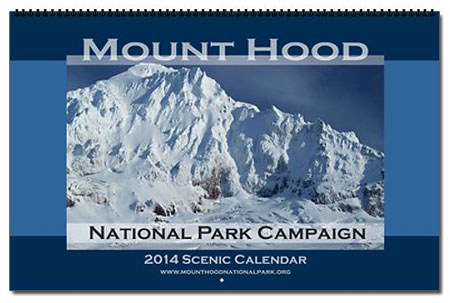
Each year at about this time I assemble the Mount Hood National Park Scenic Calendar. The proceeds are modest, but do help support the Mount Hood National Park Campaign website, WyEast Blog and related project expenses. But the main purpose is to simply promote the national park concept by making the case for the campaign with pictures.
What the calendar looks like – oversized 11×17” pages you can actually use!
I’ve published the calendars through CafePress since 2004, so this year’s calendar marks the tenth edition. All of the photos in the calendar are from trips and trails I’ve explored over the past year.
I get a surprising number of questions about the photos, so in addition to simply announcing the 2014 calendar, this article tells a bit of the story behind the new images.
The 2014 Scenes
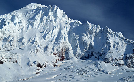
Cover: Sandy Headwall and Glacier from McGee Ridge
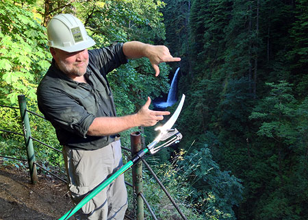
The cover photo of the Sandy Glacier headwall is really a nod to a chance encounter I had with Brent McGregor, the fearless cave explorer profiled in the Thin Ice: Exploring Mount Hood’s Glacier Caves, a recent Oregon Public Broadcasting feature. I had just posted a WyEast blog article on the program a few days prior, and happened to run into Brent and his climbing partner, Eric Guth, on the Timberline Trail that day in October.
Brent and Eric were on their way down from spending the night in the Snow Dragon glacier cave, and provided me with an amazing personal account of their adventures inside the caves. I also learned a bit of the glacier cave geography from the spot where we met atop McGee Ridge. The cover image for the calendar was taken from that spot awhile after the (now famous) ice cave explorers continued down the trail. A most memorable evening!
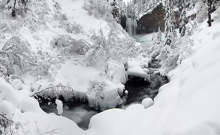
January: Tamanawas Falls dressed in white
The monthly scenes begin with a snowy afternoon at Tamanawas Falls in the January image (above). The photo was taken in December 2013, and stitched together from three separate photos — the first of three such composite images in this year’s calendar.
The conditions were perfect that day, and a bit deceptive, as this was the first big snowfall of the season — and thus we was able to simply hike up the trail without snowshoes, albeit with the aid of boot spikes.
Brother-in-law David taking in the magic at Tamanawas
My brother-in-law David joined me for the hike to Tamanawas Falls, celebrating his return to Oregon after spending the past thirty years living in distant places, far from the life he knew growing up here among tall trees, big mountains and countless waterfalls – the best kind of reunion!
The February image (below) is an evening scene from one of the viewpoints along the historic Bennett Pass Road. The blanket of valley fog rolled in just as the sun dropped behind the mountain ridges, making for an especially peaceful scene.
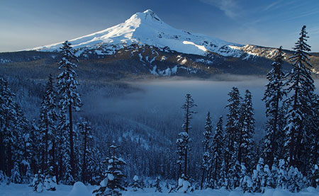
February: WyEast’s under-appreciated southeast side from near Bennett Pass
Ironically, the story behind the image is anything but quiet, as I was visiting Bennett Pass on New Years Day — apparently, along with the rest of Portland area population!
A “pristine” framing of this image suffered as a result, as the fresh blanket of snow from the previous night had already been heavily trampled by the small army of skiers and snowshoers (and their dogs) that day! Otherwise, I would have loved to included this image (below), with a pretty little noble fir in the foreground in the calendar. Maybe I should bring along a rake next time..?
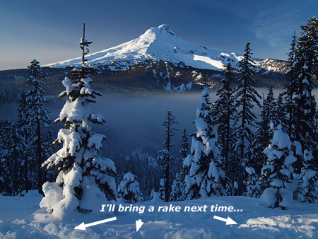
Heavy ski and snowshoe traffic on New Years Day!
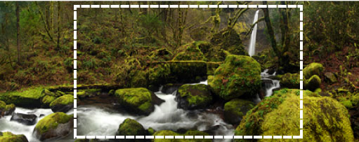
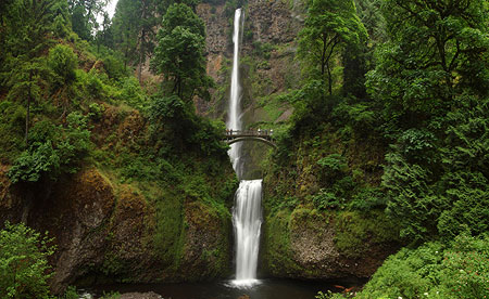
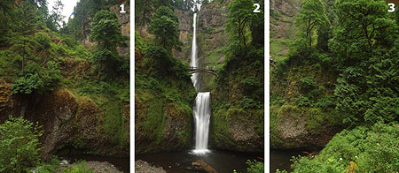
For the March image, I picked a mid-winter Gorge scene captured at Elowah Falls on McCord Creek, just west of Cascade Locks (below). This is another composite image, made from a total of six photos, with the goal of giving a panoramic feel that matches the immensity of the setting.
This is the finished image:
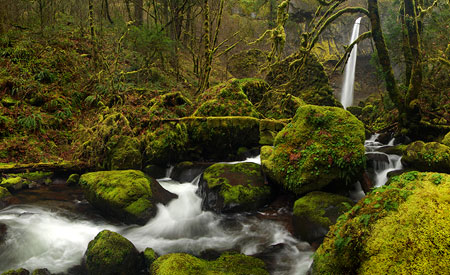
March: Elowah Falls in late winter hues
The six separate images look like this before merging:
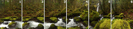
Six photos make up the original panorama at Elowah
Once merged, I cropped the final image to fit the dimensions of the calendar:
The calendar image was then snipped from the composite image
There’s a bit of a story to this scene, too: the graceful, multi-trunked bigleaf maple framing the falls will soon succumb to the power of McCord Creek, as the stream has recently eroded the bank to the point that the main trunk of the tree is hovering over the creek, in mid-air (below).
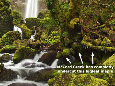
Change is coming to this maple along McCord Creek
This section of McCord Creek has suddenly experienced a lot of erosion in the past few years, so this is part of a larger change happening to this iconic spot – much more to come as we watch the power of nature at work, and a reminder that change is constant in the natural landscape!
For April, I picked a familiar spot in the Columbia Gorge at Rowena Crest (below), where the blooming lupine and arrowleaf balsamroot frame the river and town of Lyle in the distance. It was a typically blustery day in the Gorge last spring when I visit this spot, and though the overall bloom in the east Gorge in 2013 was somewhat disappointing, the McCall Preserve at Rowena still had a very good flower show.
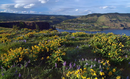
April: blustery winds at Rowena Crest..? Naturally!
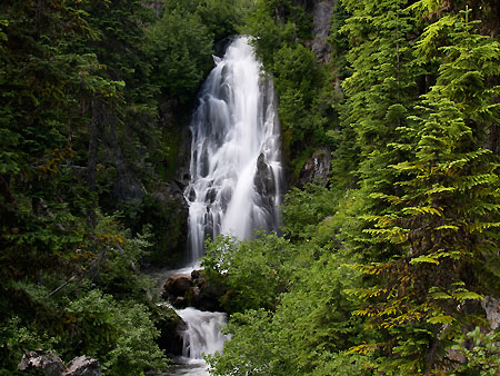
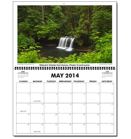
The May image (below) is from the wonderful little loop trail at Butte Creek Falls, an gorgeous little canyon in the otherwise heavily logged foothills southwest of Mount Hood. This view shows the upper falls, a quiet, understated cascade that hides an impressive cave tucked behind the falls. The main falls of Butte Creek if just downstream.
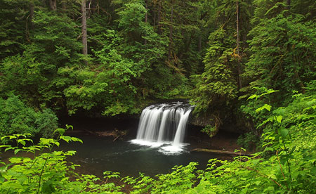
May: pretty Upper Butte Creek Falls is tucked away in serious logging country
I enjoy this trail because of the contrasts, as the approach to the trailhead passes through some of the most horrendously cut over timber corporation holdings in Oregon. By comparison, the vibrant, mossy canyon holding Butte Creek is a reminder of what we’ve lost — and hopefully will restore, someday.
Spring is waterfall season in Oregon, so the June image stays with the theme, this time countering little-known Upper Butte Creek Falls with the queen of all Oregon cascades, Multnomah Falls (below).
June: a composite photo from a very busy viewpoint
This image is the third blended photo in the 2014 calendar, this time composed of three separate images (below) taken at the perennially crowded lower overlook along the Multnomah Falls trail. As with the other composite images, my goal was to give broader context to the scene — in this case, the massive array of cliffs that surround Multnomah Falls.
Three photos came together for the Multnomah Falls image
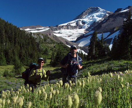
As always, mountain scenes fill the summer months of the calendar, starting with a view of Mount Hood’s towering west face for July (below). This image was captured in mid-July, and though a bit late for the full glory of the beargrass bloom, it does capture the final phase of the bloom. This scene is from one of the hanging meadows high on the shoulder of McGee Ridge, looking into the valley of the Muddy Fork.
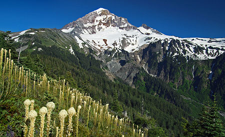
July: beargrass bloom in the hanging meadows above the Muddy Fork
For the August calendar scene, I chose an image from a hike to Elk Cove. It’s a bit of a repeat from past calendars, but one of my (and most everyone else, I suspect) favorite views of the mountain. The alpine bloom came late to Elk Cove this year, and still hadn’t peaked when I shot this photo in early August:
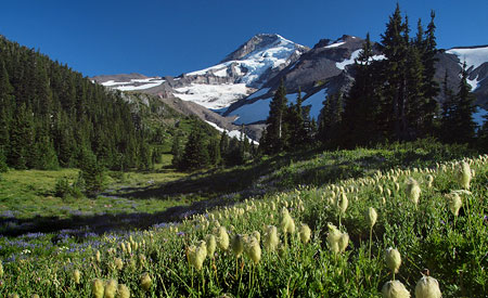
August: my annual pilgrimage to “the view” from Elk Cove
I’ve shot this scene many times, but on this particular trip several hikers passed by while I waited for the afternoon light to soften. Two groups stopped to chat and pose for me, including a pair of hiking buddies doing the Timberline Trail circuit and a family from Olympia, Washington visiting Elk Cove for the first time (below).
Round-the-mountain hikers arriving for a night at Elk Cove
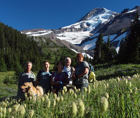
This group traveled from Olympia to visit Elk Cove
Both shots let out a little secret about my favorite photo spot at Elk Cove: it’s only about ten feet off the Timberline Trail, which crosses right through the drift of western pasque flower in the foreground!
For the September scene, I picked an image of Wiesendanger Falls on Multnomah Creek (below), named for Albert Wiesendanger, a pioneering forester in the Columbia River Gorge.
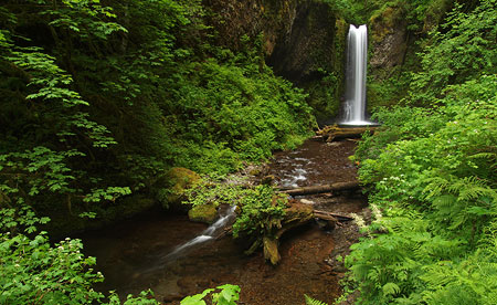
September: Albert Wiesendanger earned a place name with his falls on Multnomah Creek
Most hikers are (understandably) looking upstream, toward Wiesendanger Falls, when they walk through Dutchman’s Tunnel (not a true tunnel, but more of a ledge carved into the basalt cliff) along Multnomah Creek, just below the falls.
Thus, few see this inconspicuous bronze plaque at the south end of the tunnel honoring Albert Wiesendanger:
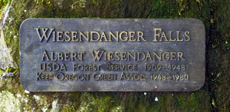
Wiesendanger not only had an important role in shaping of the trails and campgrounds we now enjoy in the Columbia River Gorge, he also went on to lead the Keep Oregon Green campaign. He is a little-known giant in our local history, and deserves to have his story more widely told.
The October scene isn’t from a trail, but rather, a somewhat obscure dirt road high on the shoulder of Middle Mountain (below), in the Hood River Valley. I learned of this spot several years ago, and often make the bumpy side trip if I’m passing through in early evening — it’s one of the more stunning views in the area, showing off the spectacular Upper Hood River Valley at its finest.
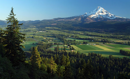
October: The upper Hood River Valley from a lesser-known viewpoint on Middle Mountain
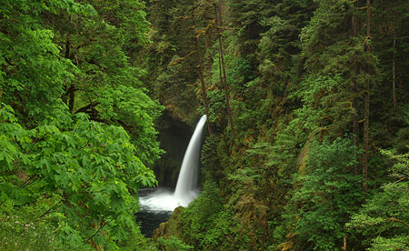
For November, I chose a photo of Wahclella Falls on Tanner Creek taken a year ago (below), in early November 2012. Why? Because the monsoons we experienced in September of this year really did a number on the fall colors. Foliage was battered by the winter-like weather, and trees were deprived of the normal autumn draught conditions that help put the brilliance in our fall.
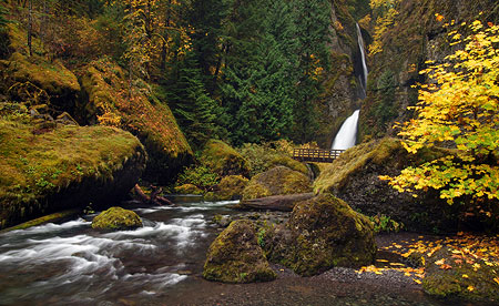
November: Tanner Creek as it would normally appear in early November
The result of our cold, wet September was a very early leaf fall and generally muted fall colors, as can be seen in these views of Wahclella Falls taken from the same spot at almost the same time of year in 2012 and 2013:
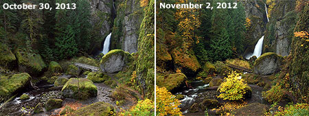
Our rough September weather in 2013 was devastating to autumn foliage
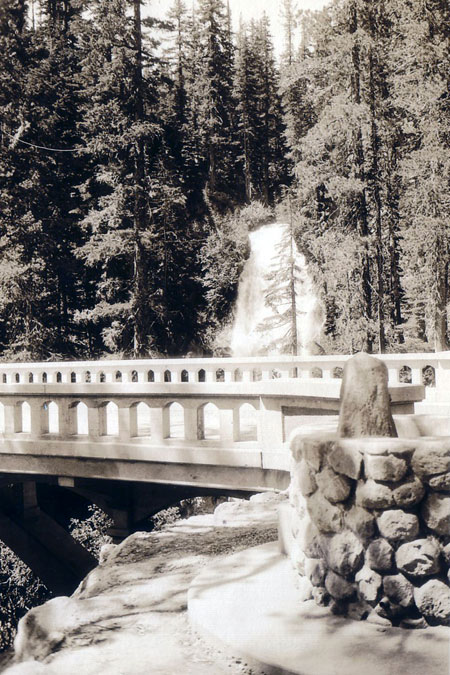
Finally, a winter scene along the East Fork of the Hood River (below) wraps up the 2014 calendar as the December image. This photograph was taken from the footbridge leading to Cold Spring Creek and Tamanawas Falls, and was captured on the same day as the opening January image in this year’s calendar.
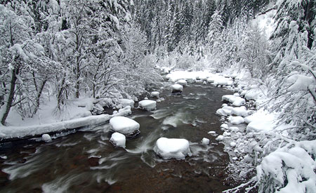
December: The East Fork Hood River in winter
Among the missing elements in this year’s calendar are scenes from the Cloud Cap area and Cooper Spur, on Mount Hood’s north side. This is largely due to the indefinite closure of the historic Cloud Cap Road, abruptly announced by the Forest Service earlier this year.
This road closure had a big impact on recreation. While it’s possible for seasoned hikers to make the much longer trek from the nearby Tilly Jane trailhead, for most (especially families and less active hikers), it means that Cooper Spur and the spectacular views of the Eliot Glacier will have to wait until another year.
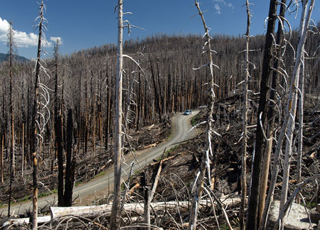
Cloud Cap Road in 2010: salvage logging slash lines the road two years after the Gnarl Fire swept through in August 2008
The reason for the Cloud Cap Road closure is a bit more worrisome: five years after the Gnarl Fire roared through the area — and four years after an extensive salvage logging operation toppled hundreds of “hazard” trees along the road — the Forest Service has decided that standing trees must once again be felled in order to “protect the public”.
Oddly enough, the road remains open to hikers, skiers and cyclists — apparently because the hazardous trees only fall on cars? We can only hope that the scars from this latest “improvement” don’t further degrade the historic road, when huge piles of slash were left behind, where they still line the old road.
One that didn’t make it…
Metlako Falls (from the wrong side of the fence)
The above view of Metlako Falls on Eagle Creek was in my folder of favorite 2013 images to include in the annual calendar, but I decided to save the scene for another year. Why? Because in July, I headed up a mighty (okay, two-man) Trailkeepers of Oregon crew to clear out the brush that has blocked safe viewing of Metlako Falls for many years.
Previously, the only way to capture a photo like the one above, photographers had to step OVER the cable hand rail, and stand perilously close to the 200-foot brink dropping into the Eagle Creek Gorge. The hazard to hikers was bad enough, but the “sweet spot” for photos was so over-used that it was starting to erode the ground underneath it, potentially destabilizing the rest of the cliff-top Metlako Falls overlook.
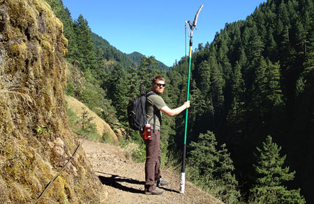
Chris Alley was one half of the TKO crew, and the only hiker with a 16-foot pole pruner on the Eagle Creek Trail that day!
The solution was straightforward: the Gorge unit of the Forest Service approved our plan to trim the offending brush using a 16-foot pole saw. This kept us safely on the uphill side of the cable fence, with just enough reach to clip the brush.
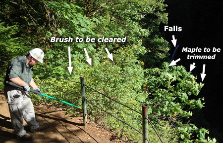
The task at hand: trim overgrown brush and maple limbs
With my Trailkeepers partner Chris Alley along for the project, we made quick work of the offending branches on a rather hot, sticky day. After a couple hours of sawing and lopping, Metlako Falls was once again safely in view! This is a project I’d wanted to do for awhile, so it was great to finally have it sanctioned as a Trailkeepers of Oregon project.
The author: “I can see clearly now (the brush is gone)!”
Now, I’m looking forward to next spring, when I’ll head up there during the waterfall prime time to re-capture the scene — safely, this time! I’ve already been back this year, and enjoyed seeing casual hikers admiring the unobstructed falls, snapping photos on their iPhones.
_________________
The thirteen images I chose for the 2014 calendar are from a few thousand images I’ve taken this year on close to 50 outings to Mount Hood and the Gorge! As always, the magnificent scenery only strengthened my conviction that Mount Hood should (and will!) be set aside as a National Park! Hopefully, the scenes in the calendar continue to make the case, as well.
How can you get one?
The new calendars are available online:
2014 Mount Hood National Park Calendar at CafePress
They are large and functional, measuring 17” across by 22” tall when hung, with plenty of room for writing notes and scheduling activities. CafePress packages them carefully, with each calendar sealed against a corrugated cardboard backing for support. You can also order them with gift wrapping at additional charge.
The calendars sell for $29.99 + shipping, with about 25% of the proceeds going to support the Mount Hood National Park Campaign. They make terrific stocking stuffers (…although you’ll need an 11×17” stocking…), and CafePress now makes it even easier by offering PayPal as an option.
And as always, thanks for your support of the blog and the campaign!