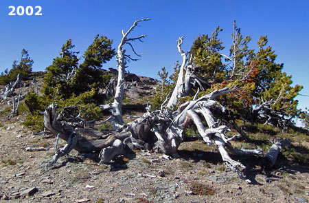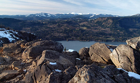
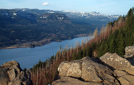
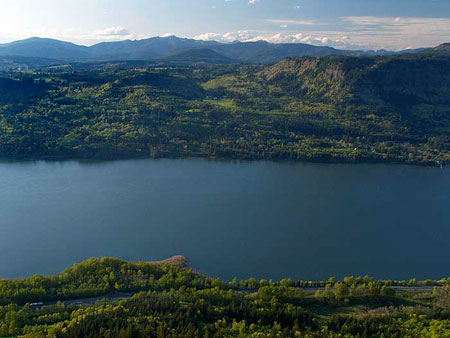
Looking across the Columbia River in winter to the Silver Star Range from Angels Rest
The popular hike to Angel’s Rest in the Columbia River Gorge is a rite of passage for long-time Oregonians and newcomers alike, because for many of us, this beautiful trail was our first hiking experience. I first hiked the trail sometime in the 1970s, and have returned many times over the years — most memorably, on the inaugural Trailkeepers of Oregon stewardship project in April 2008.

The (formerly skinny and shaggy) author on top of Angels Rest in 1981 and an older, wiser and (and much balder) version in 2013!
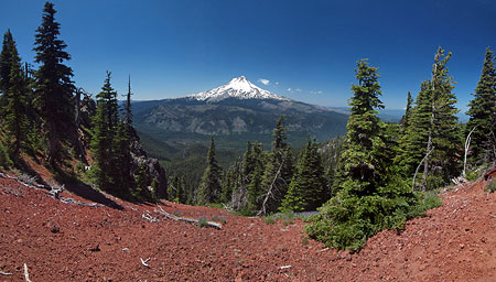
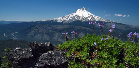
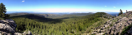
The trail has a lot to offer, with sweeping views of the Columbia River Gorge and a brief streamside section along Coopey Creek (which cascades over a pair of waterfalls below the trail). Since the Multnomah Falls Fire of 1991, the hike has offered a close-up look at a recovering forest along the upper reaches of the trail. The 1,600 elevation gain over 2.4 miles to the top of Angels Rest is within reach for most hikers, yet challenging enough to give any hiker a thrill when reaching the rocky, often blustery summit.
The Angels Rest trail also has the distinction of being among the most accessible to Portland, with a trailhead located at a freeway interchange 30 minutes from downtown, and with enough parking to supply a small army. Add the emergence of year-round hiking on our low-elevation trails in recent years, and the unfortunate result is one of the most rapidly deteriorating trails in our region.
The Angels Rest trailhead was expanded and improved in 2000 to include stone walls and trailhead signage in the style found elsewhere along the Historic Columbia River Highway
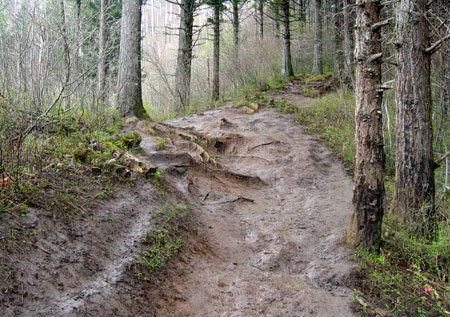
The gradual deterioration of this old trail takes many forms. Along the lower section, the once-narrow traverse across moss and fern-covered talus slopes has broken down, with the path now straddling trees (the original trail is the upper third of the tread):
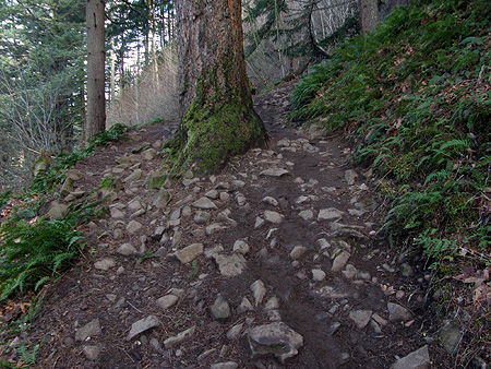
Over time, this could damage the roots of the tree in the above photo to a point where it cannot survive. This threatens not only the tree but also the trail, as tree roots are critical in holding steep, loose Gorge slopes together in a climate where annual rainfall exceeds 100 inches per year.
This badly eroded spot is the overlook above Coopey Falls, along the lower trail:
The damage here is fairly obvious: the original trail hugged the vegetation line along the right, but the crush of hikers attempting to view the falls has stripped away both vegetation and soil on the left. Over time, this has left roots of trees clinging to edge of the cliffs below exposed and unlikely to survive, making the trees themselves less likely to survive.
Beyond the Coopey Falls viewpoint, the trail reaches the first of many sections showing the impact of year-round hiking on the trail. Here, winter hikers have worn the new path to the left of the main trail tread in an effort to avoid standing water and mud in the main trail, which has become trenched from overuse:

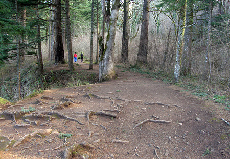
Further up the trail, the path has become so wide that the edges are almost hard to determine:
The hikers in the distance in the view above offer a clue as to how this happens: as trails widen from overuse, hikers start waking side-by-side. It’s a natural instinct, but one that the trails were never designed to accommodate.
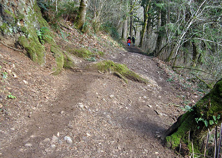
The scene below shows another example of winter hikers wearing down the edges of the formal trail in an effort to stay out of the mud:

While walking adjacent to the trail might work for the first few hikers along one of these sections, in the end, it just creates more mud during the wet season — and an even wider trail as hikers continue to push the edges of the trail outward.
Until a few years ago, the effects of hiking were on display to epic proportions along an upper section of trail, where an enormous mud pit formed as hikers continued to walk ever higher on the shoulders of the widening trail:
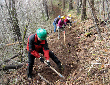
The section shown above devolved so badly that in 2008, the [url]Trailkeepers of Oregon (TKO)[/url] worked with the U.S. Forest Service to simply bypass that segment with a new trail alignment. The following photo shows TKO volunteers constructing this new section in April 2008:
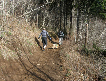
While the new trail was built to a conventional width, the continued heavy, year-round crush of hikers has since “widened” this section to nearly double its original width in just five years:
The upper trail includes several switchbacks, and these are traditionally the Achilles heel of any Gorge trail. Newbie hikers and kids can’t seem to resist cutting switchbacks.
Normally, this is manageable by simply blocking shortcuts to discourage the relatively small number of rogue hikers. But with the heavy foot traffic on the Angels Rest Trail, the sheer volume of switchback cutting overwhelms the trail, turning well-designed turns into a muddy, sloping mess:
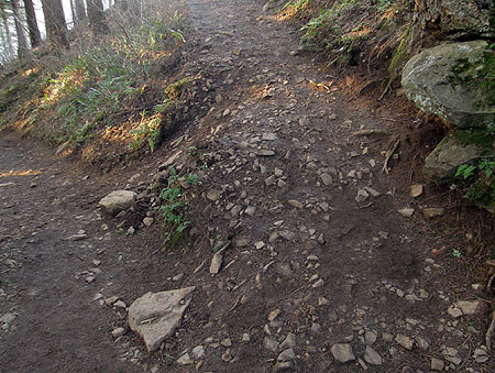
The above switchback was also built with the trail relocation project in 2008, and has barely survived five years of heavy travel from Angels Rest hikers.
The long-term answer to overuse at Angels Rest is to provide new, badly needed hiking alternatives in the Columbia Gorge, such as the Bridal Veil Canyon Trail proposed on this blog.
But Angel’s Rest needs help, too. One way to help this old trail survive for future generations to enjoy is to simply cut the traffic in half — not through restrictions or trail fees, but by creating a one-way hiking loop. The rest of this article outlines a proposal for making this happen.
Creating an Angels Rest Loop Trail
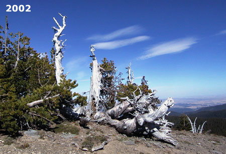
Winter view into the Gorge from Angels Rest
The concept of a one-way Angels Rest loop is simple: construct a separate, new route to Angels Rest that would form the return leg of the loop. The result would instantly cut the number of boots on the Angels Rest Trail by half, allowing the existing sections to be rehabilitated so that this old trail can last indefinitely.
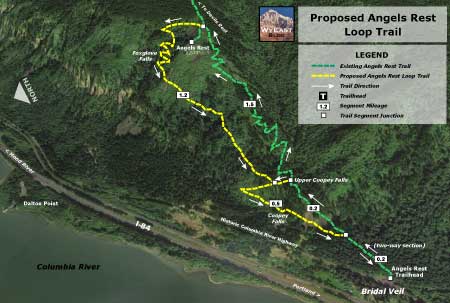
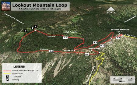
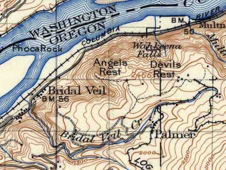
The proposed loop trail would split from the existing route about 0.2 miles from the trailhead, just before the current route heads across the lower talus slopes (see map, above). The existing trail would continue to be 2-way for the first 0.2 miles, where the gentle terrain allows for a wider trail.
The new route would function as the downhill portion of the loop so that it could be designed with downhill travel in mind. This would include a gentle incline and minimizing the number of switchbacks compared to the current route. This could have tremendous benefits for the existing route, as a disproportionate share of trail damage to the existing route is from hikers speeding downhill.
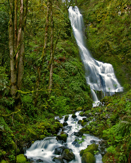
Upper Coopey Falls would be a highlight of a connector between the new and existing trails
The new return trail would also be designed to have a mid-point connection to the existing trail via a new bridge across Coopey Creek at Upper Coopey Falls (pictured above). The purpose of this connection is to bring hikers to the upper falls on a formal trail where several muddy boot paths have already been worn into the canyon walls by hikers seeking a view.
The mid-point connection would also allow less hardy hikers or families with small children to simply complete a lower loop of just over a mile in length, while still respecting the one-way trail system. The mid-way connector would also lead lower-loop hikers past beautiful Coopey Falls, one of the highlights of the proposed return trail.
The new trail would take hikers past the base of beautiful Coopey Falls, located on public land, but currently only reachable by crossing private property
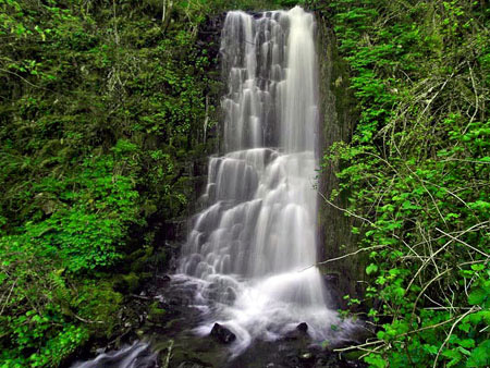
From the summit of Angels Rest, the proposed return route would descend through the hanging valley immediately east of summit. This new route would skirt little-known Foxglove Falls, a wispy 120-foot seasonal cascade hidden in the forest, then switchback down to a basalt bench that wraps around the base of Angel’s Rest. Here, the trail passes through the fire zone, and would have broad views of the Gorge before descending in a gentle curve to the new junction at the Upper Coopey Falls connector trail.

The proposed loop trail would traverse below these cliffs on the north side of Angels Rest
From the Upper Coopey Falls connector, the new route would continue to descend, passing the base of Coopey Falls on a new footbridge, then traversing west, where it would reconnect with the main trail near the trailhead, completing the loop.
The new trail would have views like this of the Columbia River Gorge
The new return trail would travel 1.7 miles in its descent, exactly the same length as the climb along the existing trail. Thus, the hike to Angel’s Rest along the new loop would retain the same mileage and elevation gain as it does today.
The Gorge viewpoints along the proposed new trail, along with stops at Foxglove Falls, Upper Coopey Falls and Coopey Falls, would be significant enhancements to the hike, making a classic trail even better. So, what would it take to realize this proposal?
An Idea within Reach…
This 1911 map shows an upper trail to Angels Rest from the long-vanished mill town of Palmer, long before the Depression-era trail we know today was constructed
The proposed loop trail would be built entirely on public lands, and much of the work could be done by volunteers working in partnership with the Forest Service. Beyond the actual trail, here are some of the other elements of the project, and more opportunities to involve volunteers in the work:
Footbridges: the proposed new loop trail would require two new footbridges: at Coopey Falls and Upper Coopey Falls. These could be excellent volunteer opportunities, as volunteers have helped construct other trail bridges in the Gorge in recent years
Invasive Species: like many spots in the western Gorge, the slopes of Angel’s Rest host invasive species – in particular, English ivy, Himalayan blackberry and Shiny Geranium. The new loop trail segment would actually improve the ability to control these species by providing new access to affected areas. Native plant advocates could become partners in the project in order to remove invasive plants as part of trail construction.
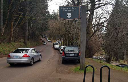
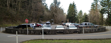
Even on the grayest of winter weekends, cars spill far beyond the overflow parking area at Angels Rest, lining the shoulders of the Historic Highway
Trailhead Facilities: the existing parking area, including the large overflow area and shoulder parking along the Historic Columbia River Highway, is more than adequate to serve the proposed loop. In fact, the loop is in response to a trail that is inadequate for the parking! But the trail does not have restroom facilities, a serious deficiency with unpleasant repercussions for a site that can have as many as 100 cars on a busy weekend. The Forest Service and Oregon State Parks and Recreation could partner to address this need as part of creating the loop trail.
Ongoing Stewardship: ongoing maintenance of the trail is also well suited for volunteers, and could be a blueprint for a new, more intensive effort to keep trails in top condition, addressing trail damage before it spirals. The trailhead is close to Portland and easy to find, and the proposed loop route would be short enough for most volunteers to navigate with equipment, or when carrying out debris. The low elevation of the trail means more opportunities for volunteer work, and the beauty and close proximity to Portland would make it an attractive volunteer option.
What can you do?
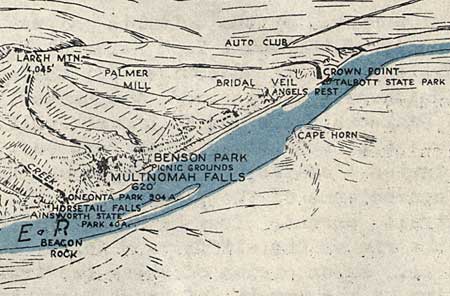
Angels Rest was one of the scenic highlights along this 1938 Auto Club guide to the Historic Columbia River Highway.
If you like this proposal, there area couple of opportunities to weigh in right now and make your voice heard:
1. Send off an e-mail to the staff at the Columbia River Gorge National Scenic Area: here’s the link (you can use the feedback form at the bottom of their web page). This is the federal agency responsible for most of the trails in the gorge, and would be the lead agency in making this loop happen.
2. Weigh in with Oregon Parks & Recreation Division (OPRD), the state agency that operates the series of state parks along the Historic Columbia River Highway. While much of the proposed Angels Rest loop trail travels on U.S. Forest Service lands, the loop also crossed state parks lands. Over the next year the state is conducting a long-range planning effort to scope future recreation needs in the Gorge. You can weigh in over here, using their blog comment format to make your voice heard.
The State Parks and Forest Service national scenic area staff work together to plan and maintain trails in the Columbia River Gorge, so weighing in with the state planning effort is an opportunity to make any of your ideas on recreation needs known to both agencies. So far, the State Parks have had fairly light participation in their public outreach, so it’s important to make your views known!
Don’t be shy about including links to the Bridal Veil Canyon and Angels Rest Loop proposals in this blog, either — here are the quick links to paste into your message:
https://wyeastblog.org/2012/01/15/proposal-bridal-veil-canyon-trail/
https://wyeastblog.org/2013/08/31/angels-rest-loop-one-way-trip-to-heaven/
Finally, consider supporting Trailkeepers of Oregon (TKO), a local non-profit, grass-roots organization that offers meet-up trail stewardship projects in the Gorge and around the region (full disclosure: the author is a founding and current board member of TKO and number one fan of the organization!)