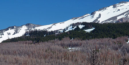
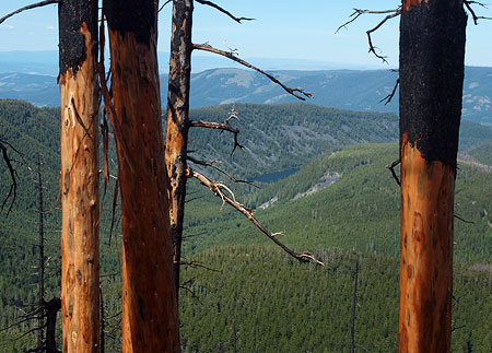
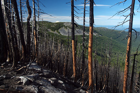
After the Dollar Lake Fire

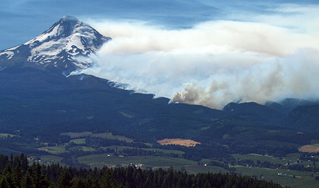
The Dollar Lake Fire from Bald Butte on September 3, 2011

On August 26, 2011, a lightning strike ignited what was to become the Dollar Lake Fire, on Mount Hood’s rugged north side. The fire started in the Coe Branch canyon, just below the Elk Cove trail, and was spotted by numerous hikers.

Initially, it seemed small and manageable. But over the next few days and weeks, arid conditions and strong winds spread the fire from Stranahan Ridge on the east to Cathedral Ridge on the northwest side of the mountain, eventually consuming some 6,300 acres of high elevation forest. The blaze burned through September and into early October, when fall rains finally arrived.

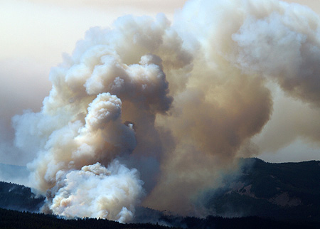
Hot spot erupts along Stranahan Ridge on September 3, 2011

Some of the burn was of the beneficial form, a mosaic fire leaving islands of surviving trees, but much of the fire was too hot and the accumulated forest fuel too plentiful to prevent devastating crown fires from sweeping across the forest. Eventually, the fire destroyed most of the standing timber and burned the forest duff down to mineral soil throughout most of the burn area.

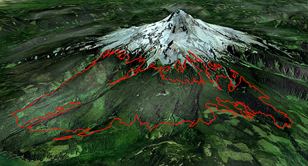
The fire was contained entirely within the Mount Hood Wilderness, thanks to the recent Clear Branch additions that expanded the wilderness boundary on the north to encompass the Clear Branch valley and the high country surrounding Owl Point, to the north. While this complicated fire fighting, it has also created a living laboratory for forest recovery, as the USFS is unlikely to assist the reforestation process inside the wilderness boundary. The Forest Service map, below, shows the broad extent of the fire.

Final extent of the Dollar Lake Fire (outlined in red)

Though the fire burned to the tree line in several spots, a surprising amount of terrain along the iconic Timberline Trail was somehow spared. While the burn touched Elk Cove and Cairn Basin, WyEast Basin and Barrett Spur are well beyond the burned area. The Clear Branch wilderness additions to the north were mostly spared, as well.

The New Vista Ridge: After the Fire

The following is a photo essay from my first visit to the burn, on June 22, 2012, and is the first in what will eventually be a series of articles on the aftermath of the fire.

The devastation left by the fire is awesome to witness, but also starkly beautiful when you consider the context of a forest fire. After all, this event is part of the natural rhythm of the forest just as much as the changing of seasons.

From this point forward, we will have a front-row seat to the miracle of life returning to the fire zone, much as we’ve watched life return to the Mount St. Helens blast zone over the past 32 years. And as my photos show, the rebirth of the forest ecosystem has already begun on Mount Hood’s northern slopes.

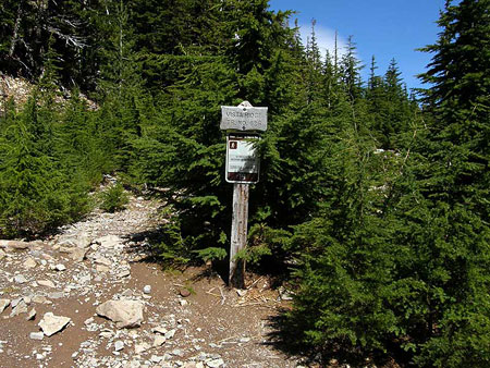
Untouched trailhead at Vista Ridge.

From the Vista Ridge trailhead, I followed the Vista Ridge Trail to the snow line, above about 5,000 feet. The Vista Ridge trailhead is completely untouched, though the fire swept through a vast area immediately to the south. Yet, no sign of the fire is evident at the trailhead marker (above).

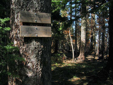
A bit further up the trail, at the Old Vista Ridge trailhead, the fire zone comes into view. Where green forests existed last summer, browned foliage and a burned forest floor spread out east of the junction. This fringe of the fire is of the healthy “mosaic” form, sparing large trees, while clearing accumulated forest debris.

Old Vista Ridge trailhead spared by fire… just barely.

An unexpected benefit of the fire came last fall, when the USFS added the long-neglected Old Vista Ridge trail to official agency fire maps (below) released to the public. Volunteers began restoring this beautiful trail in 2007, but formal acknowledgement of the route on USFS maps is a welcome development.

Welcome development: Old Vista Ridge trail reappears on USFS fire fighting maps

Clearly, the restoration of the Old Vista Ridge trail helped fire fighters reach this area, and could have served as a fire line had the blaze swept north, across the Clear Branch. Hopefully this is an indication that the Old Vista Ridge trail will someday reappear on the USFS maintenance schedule, too.

Turning south on the Vista Ridge trail from the Old Vista Ridge junction, the wilderness registration box and map board seem to have received divine intervention from the fire — the blaze burned within a few feet of the signs, yet spared both. From here, the Vista Ridge trail abruptly leaves the scorched fringe of the fire, and heads into the most devastated areas.

Vista Ridge trail signs were spared… by divine guidance?

A few yards up the Vista Ridge trail, the devastation quickly intensifies.

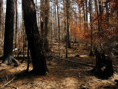
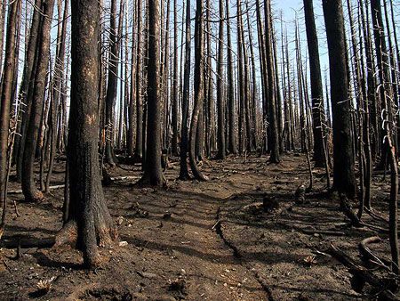
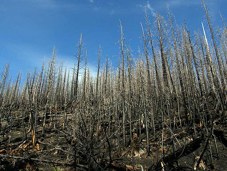
From about the 4,700 foot level, the Dollar Lake Fire burned the forests along Vista Ridge to bare earth. In this area, the entire forest crowned, leaving only a scattering of surviving trees where protected by topography or sheer luck. Forest understory, woody debris and duff burned to mineral soil, leaving a slick, muddy surface of ash. For those who have hiked through the previous Bluegrass Fire or Gnarl Fire zones on the east slopes of Mount Hood, this eerie scene is familiar.

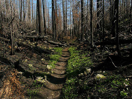
The surprisingly intact trail curves through the devastated forests along Vista Ridge.

Crown fires have killed almost all of the standing forests along Vista Ridge.

Amid the devastation in this hottest part of the Dollar Lake Fire, signs of life are already emerging. At this elevation, one of the toughest survivors is beargrass, a member of the lily family with a deep rhizome that allows plants to survive even the hottest fires. These plants are normally evergreen, but were completely scorched in the fire. The new grown in this photo (below) has emerged this spring.

Beargrass (Xerophyllum tenax) emerges from underground rhizomes protected from the fire.

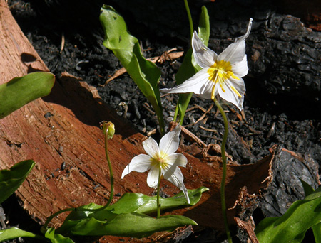
Another surprise is avalanche lily, one of the more delicate flowers in the subalpine ecosystem. Like beargrass, these plants survive thanks to a bulb located deep enough in the soil to escape the heat of the fire. As one of the early bloomers in the mountain forests, these plants area already forming bright green carpets in the sea of fire devastation (below).

Avalanche Lily (Erythronium grandiflorum) emerging from the ashes.

A ribbon of green, these Avalanche Lilies are emerging along the Vista Ridge trail.

Another of the beneficial aspects of the fire comes into view a bit further up the trail: several sections of Vista Ridge had long been overgrown with thickets of overcrowded, stressed trees that were ripe for a burn.

Over the coming years, these areas are likely to evolve into beargrass and huckleberry meadows like those found at nearby Owl Point or along Zigzag Mountain, where fires have opened the landscape to sun-loving, early succession plants.

Unhealthy forest thickets cleared by fire — a beneficial outcome of the blaze.

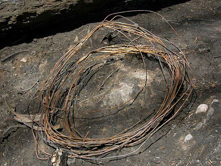
One human artifact was uncovered by firefighters — a coil of what must be telephone cable (below). This is a first along the Vista Ridge trail, but makes sense given the insulators and cable found along the Old Vista Ridge trail.

It’s hard to know what this connected to, but on the north end, it served the old Perry Lake Guard Station and lookout, just east of Owl Point. It’s possible this line extended to the Bald Mountain lookout, though I have been unable to verify this on historic forest maps.

Telephone cable on Vista Ridge – gathered up and coiled by firefighters?

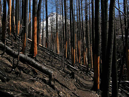
Though much of the devastation zone still consists of blackened trees and soil, some of the burned forest has begun to evolve into the uniquely attractive second phase. This happens when scorched bark peels away from trees to reveal the often beautiful, unburned wood beneath.

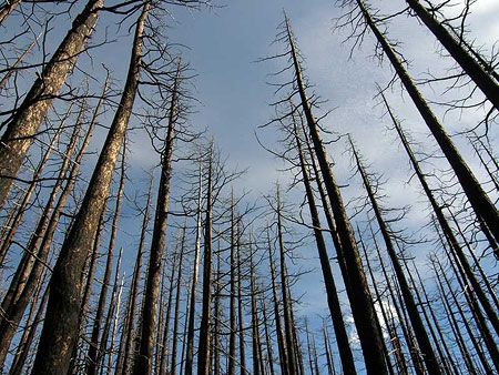
Soon, all of the trees in this forest will shed their bark. The skeletons of thousands of trees will emerge in colors of red, yellow and tan, then gradually fade to a bleached gray and white with time.
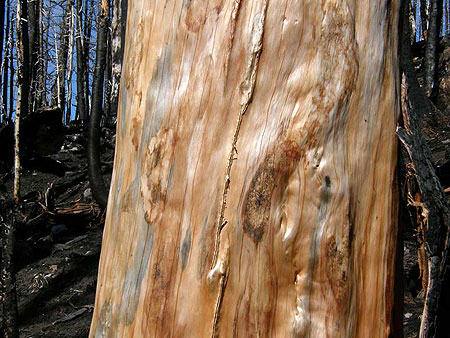
The burned trees of Vista Ridge are just beginning to shed their blackened bark, revealing beautiful trunks unscarred by the fire.

Mount Hood rises behind the new ghost forests of Vista Ridge

This second phase of the fire is helped along by winter snow. As the scene above shows, the freeze-thaw and compacting effects of the snow pack have already stripped many trees of their bark beneath the now-melted snowpack. Hot summer sun will continue this process, shrinking the remaining bark until it drops from the drying tree trunk.

This process of de-barking is the first in a post-fire sequence of events that will recycle much-needed organic matter to the forest floor. Twigs and tree limbs will soon fall, and over time, whole trees will begin to drop. This is a critical phase in stabilizing the forest soil, when low vegetation is still just beginning to re-establish in the fire zone.

Strips of tree bark are the first organic layer to accumulate on the floor of the burn zone.

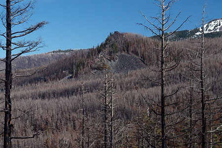
The next few images show the extent of the Dollar Lake Fire, as viewed from Vista Ridge. To the east (below), The Pinnacle was mostly burned, but the fire somehow missed stand of trees just below the north summit.

These trees will play an important role in reforestation of the area, partly because so few trees survived the fire, but also because of their geographic location above the surrounding forest, where wind will widely scatter their seeds.

The Pinnacle, where a small grove of of trees on the north slope survived the fire.

To the south, the area above Elk Cove known as 99 Ridge (shown below) was partly spared, though the fire did scorch the east slopes of the ridge. From this side (to the west), the Timberline Trail corridor was almost completely spared. Ironically, Dollar Lake — the namesake for the fire — appears to have been spared, as well.

To the west of 99 Ridge, WyEast Basin was also spared, but the area along the Timberline Trail to the west of the basin, along the upper sections of Vista Ridge, was largely burned.

Forests along 99 Ridge were spared by the fire.

This panoramic view (below) encompasses the entire mid-section of the fire, from Stranahan Ridge on the horizon to Vista Ridge, on the right. This is a new viewpoint along a largely unnoticed rocky scarp on the east shoulder of Vista Ridge, now revealed thanks to the fire.

(Click here for a much larger panoramic view]

A Changed Landscape

Those who have explored Mount Hood’s north slopes over the years will surely mourn the loss of the beautiful forests of noble fir and mountain hemlock that once stood here — I certainly have. But this is also a chance to watch the ecosystem recover and restore itself over time, as it has for centuries. Among the surprising benefits are the new scenic vistas that are suddenly available, giving a bit more meaning to the name “Vista Ridge.”

The new views from Vista Ridge include Laurance Lake and Bald Butte, to the east.

By following the true ridge top of Vista Ridge, the new views extend east across Laurance Lake and the Clear Branch valley to Bald Butte and the Columbia Basin (above). Most of the area below the ridge is not burned, and this new perspective on the recent additions to the Mount Hood Wilderness is both unexpected and beautiful.

To the north, the new views include the rugged and little-known Owl Point area of the expanded Mount Hood Wilderness (reached by the Old Vista Ridge trail). Mount Adams rises in the distance, above the talus fields and meadows of Owl Point.

Owl Point and Mount Adams from newly revealed viewpoint on Vista Ridge.

This suddenly very scenic “true” ridge along the lower portion of Vista Ridge is easy enough to hike by simply following the ridge top where the existing trail heads into a narrow draw, about one-half mile from the Old Vista Ridge trail junction. It’s worth the visit if you’d like to inspect the scenery and Dollar Lake Fire up-close.

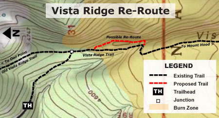
But in the spirit of recasting the Vista Ridge trail in the aftermath of the fire, and taking in these new views, now would be the perfect time to simply realign the trail along the ridge top. As shown on the map (below), this project could be done in a weekend by volunteers, if approved by the Forest Service.

(Click here for a larger map]

The fire has already done the heavy work of trail building by clearing the ground to mineral soil: designing and completing a realigned trail here would be quite straightforward. The slope of the ridge top, itself, is surprisingly gentle and would allow for an easy grade, similar to the current trail.

I hope to pitch this idea to the Forest Service, so if you’re interested in getting involved, watch the Portland Hikers forum for updates. That’s where volunteer work parties will be organized if there is interest from the USFS.

Until then, take the time to explore the fire zone, and watch the unfolding forest recovery firsthand. Visit the Portland Hikers Field Guide for directions to the Vista Ridge Trailhead.
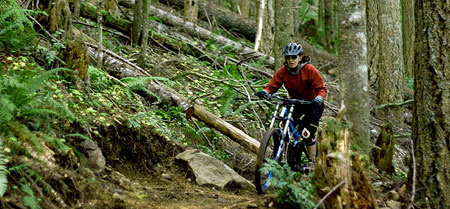
Proposal: Waucoma Bicycle Backcountry

It’s no secret that mountain bikes have been relegated to second-class status when it comes to recreation trails. They’re not allowed in designated wilderness areas, and even with the special set-asides for mountain bikes called out in the recent Mount Hood Wilderness additions, the trail options around the mountain are limited.

It’s also true that bikes and hikers don’t always mix well. Since I’m both a hiker and cyclist, I’m probably more comfortable than most hikers when it comes to shared trails. I love to hike and bike the Surveyor’s Ridge Trail, for example, but most hikers shy away because of its popularity among mountain bikers.

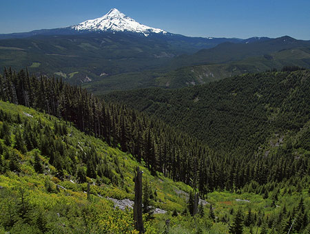
The view toward Mount Hood from Blowdown Mountain

This article is a proposal for something a little different for mountain bikers: the concept is to convert fading logging roads in a scenic area directly adjacent to the Mark O. Hatfield Wilderness to become a dedicated bicycle backcountry. In addition to providing an exciting set of mountain biking trails, the concept would specifically allow for bikepacking — overnight camping at a several destinations that would be bike-in, only.

Most importantly, this new destination would be close to both Portland and the mountain biking hub of Hood River, where bicycle tourism has become an important part of the recreation economy.

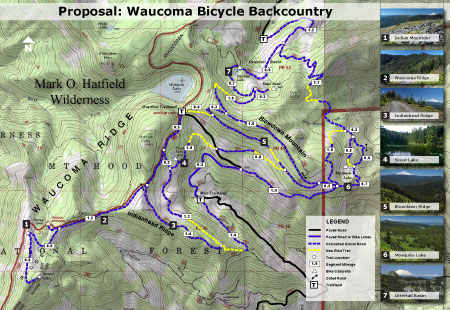
[click here for a large, printable map]

The best part of this proposal is that it wouldn’t take much to put the network together. Converting fading roads and constructing just 2.9 miles of new trail (shown in yellow on the map, above) would create a 25-mile bike network of bike-only trails (shown in blue) in an area with terrific scenery, creating as close to a wilderness experience as you can have while on two wheels.

The Proposal

The proposed bicycle backcountry would straddle the high country along Waucoma Ridge, about ten miles due north of Mount Hood. Two main trailheads would serve the backcountry: a new trailhead would be constructed in the headwaters valley of Divers Creek, serving as the primary entry into the bicycle backcountry. The existing Wahtum Lake trailhead would serve as overflow. Both are accessed on paved roads. A third, more remote trailhead would be located at the headwaters of Green Point Creek, accessed by a primitive road.

The view toward Indian Mountain from Waucoma Ridge

Trails

The proposed network has three kinds of bicycle facilities: converted logging roads (dashed blue on the map) functioning as single or dual track routes, new single track bike trails (dashed yellow) and striped bikeways (solid blue) on a short segment of paved Wahtum Lake Road that serves as a critical connection in the proposed network.

The focus of the network is on bicycle loop tours. From the proposed new trailhead, dozens of tour variations are possible, thanks to the dense network of old roads in this area, and the potential to connect and convert them. One out-and-back trail exists, following the Waucoma Road to Indian Mountain (under this proposal, the road would be gated to motor vehicles at the Wahtum Lake trailhead)

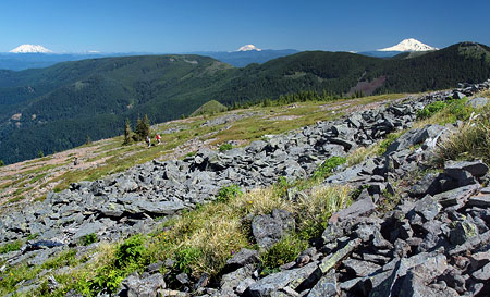
Washington’s big volcanoes fill the skyline on the slopes of Indian Mountain

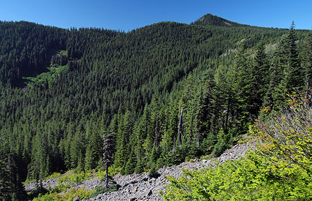
The main focus of the new trail system would be Blowdown Mountain, a surprisingly rugged shield volcano whose gentle summit ridge belies a rugged east face, featuring a craggy volcanic plug rising above a series of forested glacial cirques. An attractive spur road traverses the entire summit ridge of Blowdown Mountain, and would form the spine of the trail network in this part of the bicycle backcountry.

Three small lakes are located in glacial cirques on the northeast flank of the mountain, and views from the high ridges include nearby Mount Hood, to the south, and the high peaks of the Hatfield Wilderness, to the north. The big Washington State volcanoes complete the scene on the northern skyline.

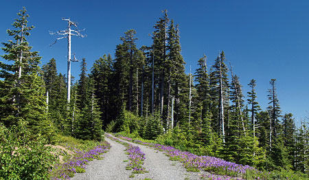
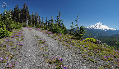
Spring wildflowers line the rustic route Indianhead Ridge with Mount Hood in the distance

The western part of the proposed network focuses on Indianhead Ridge, another high shoulder of the Waucoma Ridge complex, extending south toward the West Fork Hood River. The proposed trail network in this section would include extensive ridge top rides, with panoramic views of Mount Hood and the steep east face of Indian Mountain.

This part of the bicycle backcountry would also encompass the Waucoma Ridge Road, gating and converting the route to bike-only use except for Forest Service vehicles. The road leads through exceptionally scenic terrain, including the former lookout site on Indian Mountain, and fine views into the Eagle Creek valley, within the Hatfield Wilderness. The road, itself, forms the Hatfield Wilderness boundary.

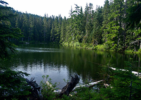
Beautiful Scout Lake in the proposed Waucoma bicycle backcountry

This section of the proposal network also includes seldom-visited Scout Lake, a beautiful forest lake that has historically been stocked with brook trout by the Oregon Department of Fish and Wildlife (ODFW).

Campsites

Five bikepacking campsites are proposed along the new trail circuit. One is simply the existing Indian Springs Campground, an excellent but largely forgotten primitive campground in need of repair. New campsites would be located at Ottertail Lake, the Talus Pond near Gray Butte, Mosquito Lake and Scout Lake, with each offering 5-15 tent sites.

Unlike the nearby Hatfield Wilderness, bikepacking campsites in the new backcountry would feature rustic picnic tables, fire rings and secure hitching racks for bicycles — features that aren’t allowed in a wilderness area, but would be welcome additions in the bicycle backcountry.

Mosquito Lake basin from Blowdown Mountain, with Mt. Defiance and Mt. Adams in the distance

What would it take?

The viability of this proposal is in its simplicity: less than three miles of new trail would open a 25-mile network, with dozens of loop options that could be tailored to the ability of individual mountain bikers. Most of the work required could be done with the help of volunteers, from trail building and campsite development to signage and ongoing maintenance. Some heavy equipment would be required to develop the new, main trailhead and decommission vehicle access to converted roads.

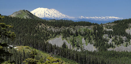
The view across Ottertail Lake basin toward Tomlike Mountain and Mt. St. Helens

Of course, the proposal would also require the Mount Hood National Forest (MHNF) to fully devote the Waucoma Ridge area to quiet recreation. A few years ago, that would have been unlikely, but in recent years, the agency has not only adopted plans to phase out hundreds of miles of logging roads, but also a policy to focus OHV use in a few, very specific areas of the forest. The recent developments could move this proposal into the realm of the possible if sufficient support exists for a bicycle backcountry.

It would take dedicated support from the mountain biking community to make the case to the Forest Service, ideally in a partnership with the agency that would include volunteer support in developing the trail system.

Cyclist on the new Sandy Ridge trail system, an example of collaboration between the USFS and bicycle advocates (City of Sandy)

The good news is that mountain bicycling organizations are already working hard to develop trails elsewhere in the Mount Hood region (such as the Sandy Ridge trail complex, pictured above) and hopefully would find this proposal worth pursuing. If you’re a mountain biker, you can do your part by forwarding this article to like-minded enthusiasts, or your favorite mountain biking organization. It’s a great project just looking for a champion!
____________

Bikepacking Resources

Bikepacking.net is an online community that focuses on off-road touring, away from cars, with great information on gear, routes and trip planning.

The Adventure Cycling Association posted this helpful article on how to pack for your bikepack trip.

Another good article on what to pack for your bikepack on the WhileOutRiding.com blog.

The International Mountain Bicycling Association is the premier organization and advocate for backcountry bicycling.

In the Mount Hood region, the Northwest Trail Alliance is the IMBA Chapter doing the heavy-lifting on bicycle trail advocacy.

Starvation Creek Loop Hike

Cabin Creek Falls

This blog has featured a series of articles on restoration of the former (and future!) Warren Falls, located in the Starvation Creek area. But there is a lot more to see in this interesting and less-traveled corner of the Columbia River Gorge, and this loop hike explores an amazing variety of scenery on a short, but demanding circuit.

Along this way, you’ll see four waterfalls, one “dormant” waterfall, ford two creeks, visit hanging meadows, peer over the brink of some truly breathtaking cliffs and enjoy expansive views of the Columbia River Gorge. You’ll want to print the large version of the trail map, below, as the trail network in the area is dense, and trail signage unreliable.

[click here for a larger, printable trail map]

The hike is best done from late April through early November, as the conditions can be somewhat treacherous in icy winter conditions, and the stream fords difficult in winter and early spring. But for adventurous hikers, this loop is generally open year-round, and provides a nice hiking option when snow covers the high country.

Hiker’s grim warning on a temporary sign at the Starvation Ridge Cutoff Trail..!

Note that the loop described here follows a specific direction, tackling the very steep Starvation Ridge Cutoff Trail first, in the uphill direction. This might seem counter-intuitive, but the steepness of this path is much harder on your knees going down than on your lungs and legs going up — and it can feel a bit slick and sketchy to descend, due to the steepness and exposure.

The Hike

The trail begins at the Starvation Creek Trailhead (directions at the end of this article). Head west from the parking area, walking parallel to the freeway exit, then drop into the trees following a section of the old Columbia River Highway. ODOT will soon be restoring this section of highway as part of a state recreation trail, so watch for construction to begin soon.

The welcome signpost marking the top of the Starvation Ridge Cutoff Trail

A short distance from the trailhead, you’ll see a signboard on the left marking the Starvation Ridge Cutoff Trail No. 414B (if you reach Cabin Creek Falls, you’ve gone too far). Take a deep breath, and begin the stiff climb up this trail, as it threads its way in a series of switchbacks through the towering cliffs that frame the Starvation Creek area.

Soon, the trail curves into the upper canyon of Cabin Creek, leaving the sounds of the freeway behind, and continuing steeply above the creek into dense forest until you reach the signpost marking the upper junction with the Starvation Ridge Trial No. 414.

The dizzying view of the trailhead from the top of the Cutoff Trail

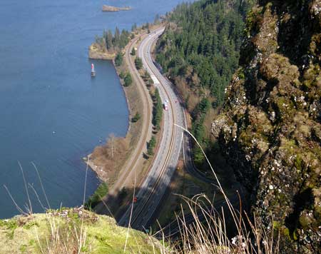
The main loop heads to the right (west), and crosses Cabin Creek. But before you continue in that direction, make a brief detour to the left (east), following the Starvation Ridge Trail uphill for about 200 yards to a spectacular cliff-top viewpoint, a few feet off the trail. From here, you can peer a dizzying 500 vertical feet down to the trailhead and the tiny cars, trucks and freight trains moving below.

Looking west toward Shellrock Mountain and Wind Mountain from the Cabin Creek viewpoint

After resting your legs (and lungs) from the Starvation Cutoff trail, and enjoying the sweeping view from the overlook, retrace your steps back to the junction, and continue west on Trail 414, fording Cabin Creek. From here, the route climbs from the Cabin Creek canyon in a series of short, well-graded switchbacks, and passes another towering cliff-top viewpoint on the right.

The trail soon crests a divide marked by a 1930s-vintage transmission tower, and descends into Warren Creek canyon in a series of switchbacks traversing an enormous hanging meadow. In late April and May, the meadow features beautiful displays of shooting star and other wildflowers, but offers stunning views any time of year.

Shooting Star in the hanging meadow above Warren Creek

Great Hounds Tongue near Cabin Creek

Soon, the trail re-enters forest, then reaches Warren Creek, a potentially difficult ford in winter and early spring. There’s no bridge here, so cross carefully. Warren Creek is the stream that once flowed over Warren Falls, just downstream from the ford. Since 1939 it has been diverted through an odd bypass tunnel that now forms manmade “Hole-in-the-Wall Falls”. You’ll pass both later on the hike.

From Warren Creek, the trail makes a gentle traverse along the forested canyon wall, then turns and crests another ridge below a second transmission tower, before descending across another open area with terrific views of the Columbia River Gorge.

The trail passes this mossy, cliff-top rock garden near Warren Creek

The view west from the Warren Creek viewpoint

The trail now descends to a 3-way junction of the Starvation Ridge (No. 414) and Mount Defiance (No. 413) trails, poorly marked with a very old signpost. From here, the loop hike continues to the right, turning steeply downhill. But first, go straight 200 yards to beautiful Lancaster Falls on Wonder Creek. This magnificent waterfall is named for Samuel Lancaster, the visionary engineer who designed the Historic Columbia River Highway.

Lower, trailside tier of Lancaster Falls

The best trailside view of Lancaster Falls is from the west bank, so be sure to rock-hop your way across. From there, you can also see part of the tall, lacy main tier of this beautiful waterfall (if you’re feeling really adventurous, it’s possible to scramble to a close-up view of the upper tier by heading uphill from the trail, just east of Wonder Creek).

After cooling off at Lancaster Falls, backtrack to the 3-way junction, and rejoin on the Starvation Ridge Trail No. 414, heading left as it descends steeply across an open slope, soon reaching a sturdy, new footbridge over Warren Creek.

Part of the magnificent main tier of Lancaster Trails, located off-trail

You’ll have views of man-made Hole-in-the-Wall Falls from the bridge, but waterfall lovers should take a few minutes to follow the obvious boot path that parallels the dry streambed to the left of the falls.

This streambed leads to the original, natural location of Warren Creek Falls — the topic of several articles on this blog. The hauntingly quiet amphitheater of the original falls is eerie, and it’s easy to imagine the sound and spectacle that once existed when Warren Creek poured over this cascade. During the periods of heavy winter runoff, Warren Creek occasionally overtops the diversion tunnel, and briefly flows down its natural falls. If you look closely, you’ll see evidence of winter storm events that have briefly brought the original falls and streambed back to life.

Warren Falls flowing in one of its rare winter appearances in March 2012

After taking in the scene at the former Warren Falls, retrace your steps on the boot path to the footbridge and turn right, continuing along the main trail for your return to the trailhead (note: the restored Historic Columbia River Highway and trail will soon be constructed in this area, with a new trailhead for the Starvation Ridge Trail relocated to this spot).

The route briefly passes an open area, and then re-enters forest. Watch for old, stone foundations covered in ivy in this area — you’re passing turn-of-the-century homesteads lost to time. Sharp-eyed hikers will also spot a pair of enormous anthills, each measuring six feet in height. A bit further, and you’ll also pass dome-shaped stone bake ovens, possibly built in the early 1900s by highway workers (see the map below for help in finding these traces of human history in the Warren Falls area).

[click here for a larger, printable map]

Finally, the trail rejoins the abandoned section of the old highway, following it to lovely Cabin Creek Falls. Photographers should take a moment to walk the short boot path to the base of the falls to capture the exceptionally beautiful scene. Crane your neck upward, and you will see the huge cliffs to the left of the falls that you skirted above on the Starvation Ridge Cutoff Trail!

To complete your journey, continue along the old highway grade back to the trailhead. A great way to end this hike is with a final stop at magnificent Starvation Creek Falls, the star attraction in this part of the Gorge. To reach the falls, head past the restrooms, and take the spur trail on the right. A string of streamside picnic tables make this an idyllic spot to relax after your hike, and enjoy a picnic lunch.
Misty base of Starvation Creek Falls

Hike Logistics

The usual Columbia River Gorge precautions apply on this hike: you’ll find poison oak, ticks and sheer cliffs, so it’s not a great choice for kids. If you’re bringing small kids on this hike, consider just hiking the lower portion to Lancaster Falls, where they will have plenty to enjoy without steep trails or dangerous exposure.

The steepness of the hike makes it a good candidate for cool weather, too. Hiking poles are especially helpful, and dogs should be leashed on this trail.

Getting there

The trailhead is at the Starvation Creek rest area, located at Exit 55 on I-84, about an hour east of Portland. The trailhead has water and restrooms, and no trailhead permit is required. The Starvation Creek exit is eastbound-only, so to return to Portland, you’ll need to drive another mile east to the Viento State Park exit, then follow the signs west to Portland.
For information on the Historic Columbia River Highway restoration project, check out the ODOT website, and click on “ongoing projects” for construction updates:

Historic Columbia River Highway Project

Visit Restore Warren Falls! on Facebook for more information on the project.