Fans of the classic 1975 edition of Jack Grauer’s “Mount Hood: A Complete History” have memorized the many rare photos and stories found only in this unique book. For waterfall hunters, the photo on page 226 (shown above) is particularly compelling. The 1890s image is titled “Wallalute Falls on Compass Creek”, and shows the tiny figure of a man at the base of a dramatic falls.
The mystery in this caption stems from the fact that USGS maps have long shown Wallalute Falls to be the prominent cascade on the Eliot Branch, just below Cloud Cap. This huge falls is visible from Inspiration Point on the Cloud Cap Road, and is clearly not the same as the cascade shown in the Grauer book.
This article attempts to untangle the story of these waterfalls, and the confusion surrounding the names of the remarkable, mysterious group of waterfalls spread across the Eliot, Compass and Coe drainages.
The story begins in June 2010, when I posted a report at PortlandHikers.org on my first good view of the two mapped waterfalls on the Coe Branch. I had spotted them from an off-trail outcrop on the east rim of the Hood River Valley, and captured this grainy view from a very long telephoto image:
My excitement over this sighting began with the first good look at the very tall, powerful Coe Falls. Though I had explored the brink of the falls from the Timberline Trail, I had never made the rugged descent to the base of the falls. Thus, finally seeing this magnificent waterfall in its entirety was a thrill.
I watched Coe Falls for a moment through the lens, and then to my astonishment, I realized that the adjacent falls (on an unnamed tributary to the Coe Branch) was also in plain view! While Coe Falls was towering and stately, this neighboring cascade was a sprawling, graceful veil. I gave the unnamed falls the working title of “Kalakwhahtie Falls”, which is Chinook jargon for “petticoat”, and quite descriptive of the falls (and I couldn’t bring myself to add another “Bridal Veil” falls to the long list with that name!)
Wayne Harvey’s Adventures
Based on my PortlandHikers.org report and the photo schematic I provided, local waterfall adventurer Wayne Harvey was intrigued, and in July 2010 made an epic solo trip into the Coe Branch canyon to explore and document this impressive pair of waterfalls. His trip produced the first known contemporary image of Coe Falls, thundering into its huge amphitheater:
Wayne also captured the first known photo of Kalakwhahtie Falls, cascading over the east wall of the Coe Falls amphitheater. Though the mid-summer stream levels in Wayne’s photo (below) were notably lower than in my grainy images from across the valley, his images captured a uniquely beautiful waterfall:
Wayne’s photos of Coe Falls immediately raised questions about the Wallalute Falls image in the Grauer book. The resemblance was striking, and without definitive modern images of the waterfalls on Compass Creek to compare to, another possibility arose: was the falls in Jack Grauer’s book actually Coe Falls?
Further intrigued by the unfolding mystery, Wayne made a second, even more rugged solo trip into the Coe Branch canyon in July 2011, this time to explore Compass Creek and document the remaining waterfalls of Mount Hood’s north slope.
Wayne’s 2011 return trip took him across the boulder-filled floor of the Coe Branch valley, then into the dense underbrush of the remote Compass Creek canyon. His first discovery was the lower of the two mapped falls on Compass Creek to be much larger than anyone had imagined, dropping roughly 100 feet into a picturesque bowl (below).
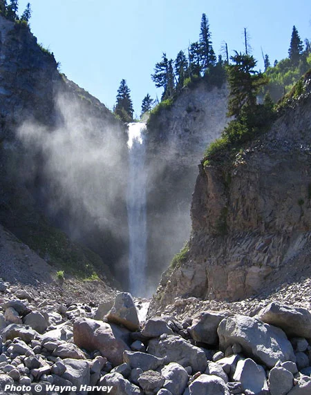
The larger-than-expected lower falls also presented an obstacle for Wayne as he searched for a route upstream to the main falls. He later described a scramble up a steep chute that was “all fours in places”, and the only passable route. Beyond the scramble past the lower falls, Wayne continued upstream to an impressive view of Compass Creek Falls, dropping nearly 200 feet into a sheer amphitheater (below).
With this image, Wayne had solved the Wallalute Falls mystery: the falls pictured in the Grauer book is clearly the same as the falls he documented on Compass Creek. Wallalute Falls is indeed on Compass Creek, not the Eliot Branch.
Unraveling the Mapping Mystery
With Wayne Harvey’s trip report from Compass Creek in hand, it was now possible to unravel another waterfall mystery. This time, the confusion involves another historic photo from the area dating from the 1890s, and titled “Strawnahan’s Falls” (below):
For years, waterfall hunters have recognized this falls to be the large, prominent falls on the Eliot Branch identified on maps as Wallalute Falls (shown below in its modern form). The reference to “Strawnahan” (which is clearly a misspelling of “Stranahan”, the name given to a nearby ridge in honor of area pioneers) was assumed to be either an informal name that was later replaced by “Wallalute” or simply an error on the historic photo, itself.

Stranahan Falls as it appears today, after years of recent flooding have scoured the Eliot Branch canyon
Wayne Harvey’s field documentation of the real Wallalute Falls now seems to provide definitive evidence that a map error occurred, transferring the “Wallalute” name from Compass Creek to the Eliot Branch, with the “Stranahan” name simply getting lost in the shuffle.
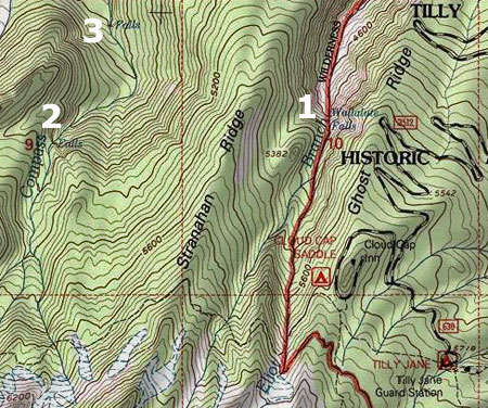
The following map provides the context for the USGS map error by showing the close, and potentially confusing proximity of (1) Stranahan Falls (labeled as Wallalute on USGS maps), (2) the true Wallalute Falls on Compass Creek, and (3) the lower falls on Compass Creek.
Still another twist in this saga comes from a later, more obscure edition of the Grauer book, published in 2006. In this edition, Grauer describes the work of Mount Hood pioneer Mark Weygandt building the earliest trails in the vicinity of Cloud Cap Inn:
“It was probably in this year (1900) that he built trails. One trail led from the low end of Ghost Ridge to a view of Stranahan Falls. He then extended it across Eliot Creek to Stranahan Ridge and to Wallalute Falls and Canon Balls Falls on Compass Creek, at the bottom of Adams’ Hole. Parts of this route later became part of [the] Timberline Trail. He also made a trail down Sand Creek Ridge to a viewpoint of the falls on Sand Creek, later named Polallie Creek.”
These accounts are the gold standard for Mount Hood history, partly because Grauer lived a good portion of it himself, but also because of the extensive spoken history he has documented through interviews of the historic figures, themselves.
Grauer’s description gives a name to the lower Compass Creek falls for the first time in recent memory — “Canon Ball Falls” — as well as the canyon section that encompasses both Wallalute and Canon Ball falls on Compass Creek — “Adams’ Hole”. Grauer is also definitive on the Stranahan and Wallalute names, correctly tying them to the Eliot Branch and Compass Creek, respectively.
Mapping the North Side Waterfalls
The USGS map error that created the confusion may go back more than a century, as it appears to be reflected on all USGS maps known to carry the name “Wallalute”. The follow map excerpt (below) is from 1924, and shows how the error could have occurred: note that early topographic maps didn’t always show the crosshatch used to denote waterfalls on more contemporary maps. With this omission, and the close proximity of Compass Creek and the Eliot Branch on earlier, small-scale maps, it’s easy to see how later cartographers might have been confused as to which stream Wallalute Falls was really on.
The following USGS map excerpt (below) was published in 1962, and is the first to attach Wallalute Falls specifically to the Eliot Branch. This map appeared when the 1:24,000 topographic series was being published, and the larger scale allowed features like Wallalute Falls to be more definitively identified — or, in this case — misidentified. Though the location of Wallalute was in error on the 1962 sheets, these large-scale maps did show the the waterfalls on Compass Creek and the Coe Branch accurately for the first time.
Pulling all of this together, the following is an oblique view of the north side region showing all of the waterfalls in context: Stranahan Falls on the Eliot Branch, Wallalute and Canon Ball falls on Compass Creek, and Kalakwhahtie and Coe falls on the Coe Branch.
Also shown are a couple of unnamed tributary waterfalls in the Coe Branch canyon, and there are surely other waterfalls yet to be discovered in this seldom-visited area.
In an effort to close the chapter on this naming saga, I plan to provide the documentation from this article to the Oregon Board of Geographic Names (OBGN), in hopes that they can eventually look into the matter and perhaps correct the map error of more than a century ago.
Visiting the Waterfalls
The series of waterfalls described in this article are remote and difficult to reach. Visiting these waterfalls is only for expert explorers.
Wayne Harvey approached the Coe and Compass Creek falls from the Elk Cove Trail, dropping into the canyon just beyond the prominent Coe Canyon overlook. This required a rugged descent of nearly a thousand vertical feet, followed by challenging bushwhacks at stream level to the waterfalls.

1920s Visitors to Cloud Cap taking in the view of Stranahan Falls (just to the right of the small tree in front of the car) and Mount Hood from Inspiration Point
Stranahan Falls can be seen from Inspiration Point, but represents a potentially dangerous descent into a canyon that has been destabilized by recent floods. However, there are good views of the falls from a boot path that descends to a rocky overlook, just below Inspiration Point on the Cloud Cap Road.
One of the trail concepts in the Mount Hood National Park Campaign calls for a “low trail” paralleling the Timberline Trail. On the north side of Mount Hood, this new route would connect the dots among the string of waterfalls described in this article. Wayne Harvey’s remarkable images of the waterfalls only underscore the case for providing access to these beautiful places, hiding in plain sight.
Acknowledgements: special thanks to Wayne Harvey for the use of his images and field reports, and to both Wayne Harvey and Bryan Swan of the Northwest Waterfall Survey for their help in untangling the history of geographic names in the Eliot, Compass and Coe drainages.


Great post, Tom.
LikeLike
Wow – it really stirs my soul and imagination to learn that there are unexplored beautiful places less than a dozen miles from my home. Thank-you.
LikeLike
We’ll see what the Dollar Lake fire does to this area, too–though the falls and canyons should survive.
LikeLike
Thank you to Wayne Harvey and his adventuresome spirit which has helped to clear up the mystery of the Mount Hood falls and brought to life the beauty that most of us will never see except in pictures.
LikeLike