20:1 Odds

As part of their August 2010 feature on National Parks, Sunset Magazine gave a nod (of sorts) to the Mount Hood National Park Campaign! The surprise article explained a mysterious round of phone tag that I played with a Sunset writer in late July (though I never actually connected with her). As part of the cover story, Sunset gave odds on “Our Next National Park?” Here’s what they had to say:

3:2 – Valles Caldera National Preserve, New Mexico – in a bill for full park status

4:1 – San Gabriel Mountains, California – under study by the National Park Service

7:1 – Pinnacles National Monument, California – another monument proposed for promotion to full park status

8:1 – Mount St. Helens National Volcanic Monument, Washington – also under study, in this case by a citizens committee that may recommend bumping it from failed USFS management to National Park Service protection

20:1 – Mount Hood National Forest, Oregon – “A labor of love by a Portland city planner, this campaign faces a couple of roadblocks, the main one being it’s similar to what’s already in the NPS portfolio (hello, Mt. Rainier!)

100:1 – “Ancient Forest”, Northern California/Southern Oregon – “Another quixotic cause from a lone visionary, this 3.8 million-acres swatch would link ecosystems to help preserve species… but it’s a long shot.”

Twenty-to-one? I like those odds! The article also included a link to the campaign website, so kudos to Sunset for the free publicity, skeptical as they may be!

Of interest to me in this bit of lighthearted journalism is the old “parks as museum samples” canard that comes through — we’ve already got Mount Rainer, and it’s interchangeable with any other volcano in the Cascades. Next!

Well, that mindset actually dates back to Gifford Pinchot, and a few other early conservationists, who had no way of knowing that by the end of the 1900s most of the forests of the Pacific Northwest would be laid low, or that 10 million people would live within a few hours drive of the big Cascade peaks, looking for recreation, drinking water and a piece of what once was in America’s rainforest region.

Fortunately, the new national parks movement is redefining why we need more parks, and helping move beyond a museum collection mindset and toward a more holistic vision of ecosystem protection and restoration for all sites of national significance. With a little luck, Sunset Magazine will be featuring a new Mount Hood National Park on its cover in a few years, too.

It’s Just Another 12.6 Acres

By mid-afternoon on a busy January weekend, the main Meadows parking lot has already begun to empty.

Mount Hood’s ski resorts continue their slow-motion assault on the mountain this summer with yet another parking lot expansion at the Meadows Resort. The Forest Service has not yet released the details beyond this “proposal” statement:

“Mt. Hood Meadows Ski Resort Twilight Parking Lot.

Developing a new parking area and bus maintenance facility just behind ODOT’s Bennett Pass sand shed. This would create a new 12.6 acre opening in the forest and permanent removal of vegetation. The parking is needed to deal with existing demand.”

Without more specifics, it’s hard to know just HOW bad this idea is, except that “permanent removal of vegetation” in a “new 12.6 acre opening in the forest” might qualify for some kind of award for obtuse new euphemisms within the federal bureaucracy. Yes, it’s another parking lot.

Where is the new parking lot “behind the sand shed” proposed? We don’t know yet.

We also know that ODOT, the Mount Hood National Forest (MHNF) and the ski resorts really aren’t very interested in managing peak resort demand to minimize the need for more parking and wider highways. Beyond an anemic fleet of ski buses, there is no plan. So, this looks like more of the same, and another patch of subalpine forest will soon be erased from the slopes of Mount Hood.

The sprawling Hood River Meadows lot is mostly empty nine months of the year -- this panoramic view is on a beautiful March weekend with a 12-foot snowpack on the ground, but when most skiers are busy doing other things.

Here’s the real tragedy: like the highway widening projects proposed along Highway 26 west of Government Camp, the string of parking lots at Meadows are really only used a few days each year — a few busy weekends in December, January and February, when the Meadows resort is briefly crowded to capacity. But a look at the Hood River Meadows lot on a sunny March weekend (above) tells the real story. These parking lots mostly sit empty for nine months each year, and only fill on weekends during the 3-month “busy” period each winter.

There is a better way. The Mount Hood National Forest and ODOT could tear a page from the Deschutes National Forest playbook, and take a serious look at managing weekend crowds with a Paul S. Sarbanes Transit in the Parks and Public Lands Grant. What the is that? Well, it’s how the Deschutes NF will partner with nearby Central Oregon communities to examine the possibilities for a different transportation solution for the few winter peaks that stress the transportation system than simply putting down more asphalt. Here’s the news release (PDF).

Putting a Face on 12.6 Acres

In the meantime, this is a good opportunity to think about the magnitude of 12.6 acres. While it might seem small enough to be disposable to an agency responsible for over one million acres of public land, the proposal is “permanent”, after all. In the spirit of not taking one acre of public land for granted, here are some comparable spots in Portland that cover approximately the same acreage that provide a sense of scale for this proposal:

Portland’s South Park Blocks

The South Park Blocks in Portland stretch 12 blocks, and cover just nine acres in area. All twelve blocks would fit inside the proposed Meadows parking expansion, yet manage to include one of Portland’s largest forests of century-old elms, along with numerous fountains, monuments, plazas and walkways. Of course, in many cities, it would just be 12 more blocks of surface parking.

Tom McCall Waterfront Park

Looking rather brown in this post-Rose Festival restoration view, Tom McCall Waterfront Park is also about 12 blocks long, and covers about 13 acres. This park also manages to incorporate a number of fountains and monuments, pathways, the sea wall, plus the entire Rose Festival midway every June, as well as dozens of other festivals and concerts over the course of the year.

In the case of McCall Park, 13 acres covers a lot of terrain, but it also has a surprising history: this stretch of land was once Harbor Drive, a 4-lane highway, that city leaders tore out and replaced with a park.

The Oregon Zoo

The Oregon Zoo covers 64 acres, but the Great Northwest Exhibit only covers about a 12 acres, and is comparable to the Meadows parking proposal. Like the forests around Mount Hood, the Northwest Exhibit is home to cougars, bald eagles, black bears and salmon — plus mountain goats, river otters, sea lions and sea otters.

Holladay Park and the Lloyd Cinemas in Portland

Holladay Park, the Lloyd Cinemas and the very large cinema parking lot in between fit into a space of about ten acres in Portland’s Lloyd District. By comparison to the 12-acre Meadows proposal, the four acres that fall within the cinema parking lot provides 550 parking spaces — therefore, a similarly designed lot on the acreage Meadows proposes to develop on Mount Hood would translate to 1,650 spaces! Is this possible?

The Oregon Convention Center

The Oregon Convention Center also fits neatly on about 14 acres, providing 1 million square feet of convention space, plus numerous plazas and walkways, a light rail station and truck loading bays. Unlike Meadows, the Convention Center didn’t have the luxury of simply paving over a nearby forest for overflow parking, and thus the underground structure with space for 800 vehicles.

Laurelhurst Park

Finally, Laurelhurst Park is about twice the acreage of the proposed Meadows parking lot, at 26 acres. But it gives a good visual of what the ski resort proposes to pave over with their lot. Simply imagine “permanently removal” of the vegetation on one half of Laurelhurst park, above, replaced by a parking lot.

On its 26 acres, Laurelhurst provides a concert stage, numerous monuments and art displays, tennis court, volleyball court, basketball court, soccer field, horseshoe pit, play area, picnic sites, off-leash pet area, restrooms, network of paved and soft walking paths and an interpretative historical sites — which half should be paved over for overflow ski resort parking?

What’s Next?

What will be the fate of the latest Meadows proposal to build parking on Mount Hood? Hopefully, the Forest Service will act as protective stewards of our public lands, and see more value to a 12.6 acre piece of forested land than just a bunch of trees that should be “permanently removed” to make room for skiers during a few winter weekends. We’ll see.

As details about the latest Meadows parking lot expansion are revealed, updates will be posted here, including opportunities to weigh in on the plan. After all, every acre counts, and all 12.6 acres belong to you and me, our children and their children, not the Meadows resort development.

Hiroshima Rock Centennial (1910-2010)

Hiroshima Rock and Mount Hood

Today marks the centennial of a Japanese climbing expedition to the summit of Mount Hood on July 17, 1910. The achievement would probably be forgotten by now, except for the visitors carving a record of their ascent into a glacier-polished andesite boulder at the crest of Cooper Spur.

The boulder is now informally known as “Hiroshima Rock”, and a familiar feature to generations of hikers and climbers who have since passed this spot.

Detail of Hiroshima Rock

Little is recorded about the expedition, even in the gold standard of Mount Hood history — Jack Grauer’s Complete History of Mount Hood — though the arrival of a Japanese climbing expedition surely must have been reported in the local press of the time. Lacking that written history, what follows is my own speculation on the climb.

The inscription contains both English and Japanese text, and supposedly the Japanese portion identifies the expedition as originating from Hiroshima. It is not surprising that a Japanese expedition would seek out Mount Hood. Mountain climbing had blossomed as a sport in Japan in the late 1800s, just as it had in Europe and the United States.

But the Japanese interest in climbing mountains had deeper roots, dating back centuries to the earliest spiritual pilgrimages to mountain peaks — most notably, Fujiyama.

“The Pilgrimage” captures the long Japanese tradition of mountain climbing for spiritual purposes

It is therefore not surprising that a group who had likely climbed Mount Fuji numerous times was drawn to Mount Hood, on the opposite side of the Pacific. Both peaks are part of the Pacific “Ring of Fire”, and share a common volcanic origin. Yet, Mount Hood would have been a more technical climb, with its steep, deeply eroded slopes and tumbling glaciers.

It is also likely that the Japanese party stayed at Cloud Cap Inn, or at least stopped there, since the inn was still operating in 1910, under the management of Horace Mecklem, and would have likely been snow free in mid-July. At the time, the Cooper Spur route was the most popular ascent, since Cloud Cap Inn provided the best access to the mountain.

Traditional Japanese spiritual quest to Fujiyama

Given the very active climbing schedule of the Mazamas in the early 1900s, it is also likely that the Mazamas were involved in the Japanese expedition, or at least aware that a group from Japan was on the mountain.

The Japanese expedition likely used similar climbing tools to what Europeans and Americans employed at the time: layered clothes, knapsacks and alpenstocks. The photos below are LIFE archival images from the late 1940s that capture the look and feel of Japanese climbs just after the war. These images probably give a fair sense of what the 1910 climbers must have looked like.

Japanese climbing expedition on Fujiyama in 1948

Japanese climber on Fujiyama with Lake Kawajuchi in background in 1948

The second image from the LIFE series is interesting in that it shows the climber wearing traditional Japanese tabi, or toe shoes (see detailed view, below). Modern tabi are still widely worn today in Japan, and as anyone who hikes knows, modern toe shoes are a popular new trend in the U.S., too.

Detail showing a Japanese climber wearing tabi, or toe shoes

So, why did the expedition carve their record into the rock on Cooper Spur? The most obvious explanation is simply posterity, since it was common in that era to carve your legacy into rocks or trees in a way that we would find unacceptable today.

But a more intriguing possibility might be that that expedition was holed up on Cooper Spur, perhaps stalled by bad weather, or simply setting up a base for the final ascent. This might explain the time it would have taken to chisel the Hiroshima Rock message into a very hard chunk of andesite — an effort that would likely take hours to complete.

For now, the details appear to be lost in time. But the legacy of the inscription is an elegant reminder that attraction of Mount Hood drawn visitors from around the world from the very beginning, and still does.

Postscript

Chiyoko & friends celebrating at Cooper Spur (Photo Courtesy Guy Meacham)

Just after posting this article, I learned that Guy and Chiyoko Meacham led a group up to Hiroshima Rock on July 18, 2010 to celebrate the centennial (plus one day) and Chiyoko’s birthday (to the day). After cake and champagne, Chiyoko translated the Kanji inscriptions to read:

Left side: Mie Ken Jin – Ito (Person from Mie State, [Mr.] Ito)

Right side: Hiroshima Ken Jin (Person from Hiroshima State)

English portion:

July 17th 1910
Monument
[Mr.] S. Takahashi

You can read the entire trip report and see their beautiful photos over at the Portland Hikers site: click here

Illuminating Mount Hood

A lenticular cloud hovers over Illumination Rock on a warm August evening

Visitors to Timberline Lodge cannot help but notice the huge monolith on the southwestern shoulder of Mount Hood parting the Reid and Zigzag glaciers. This 9,543 foot spire is Illumination Rock, and a signature feature on the mountain.

What few visitors know is that the rock gained its name in the early days of mountaineering on Mount Hood, when a series of expeditions were made to illuminate the mountain so that it might be seen from Portland.

Several of the early lighting schemes focused on the steep saddle above Illumination Rock, though other spots were attempted over the years, including the crater and even the summit of the mountain.

Illumination Rock and saddle, above the Zigzag Glacier

In modern times, such a scheme would involve riding a snow-cat loaded with fireworks from Timberline Lodge to the edge of the Zigzag Glacier, then using skis or sleds to reach Illumination Rock. But in the late 1800s, this effort was much more daunting.

The trip began with a day-long wagon (or horseback) ride from Portland to Government Camp on the old Barlow Road. From there, the expeditions spent the next two days hauling their explosives up the 6,000 feet and six miles to Illumination Rock – there was no convenient road to timberline, and no lodge there, yet.

Some of the expeditions used horses to pull heavy sleds, while others relied on human power to carry the fireworks to the top of the mountain. In the 1800s, the Zigzag Glacier also presented a more dangerous barrier than exists in modern times. The glacier was much larger, and the illumination teams were very much in danger of falling into crevasses.

Illustration from the 1887 expedition

The early adventurers also lacked communication that we take for granted today. A modern illumination effort would almost surely rely on cell phones for coordination and safety, while the early efforts relied on pre-arranged times to communicate with signal flares and mirrors.

The first recorded illumination occurred in 1870, when Perry Vickers climbed to the summit and set off several magnesium flares to celebrate July 4. The displays were seen from below on the mountain, but not from Portland.

Vickers campaigned for a larger display with potential financial backers in Portland, and staged a second display of flares in 1873. Attempts by other groups in 1877 failed due to the extreme conditions on top of the mountain. So far, no display had been seen from Portland.

The 1887 Expedition

On July 1, 1887, a blue ribbon expedition departed for Mount Hood with 100 lbs of flammable “red fire” powder and a plan to illuminate the mountain on the evening of July 4. The expedition was led by William Gladstone Steel, the legendary “Father of Crater Lake National Park” and irrepressible force of nature in his time.

1887 photo essay

Steel’s group reached Government Camp on July 2, and established a base camp high on the mountain the next day, after a difficult and sometimes harrowing trip up the mountain. The weather was bitterly cold on July 4 when the party made the final ascent to Illumination Rock, crossing the treacherous Zigzag Glacier.

Steel and Dr. J.M. Keene set up a high camp near the rock, where the illumination would occur. The rest of the party descended back to the base camp below timberline to watch and wait for dark to fall, and the scheduled lighting of the mountain. Steel and Keene finally lit the red fire powder at 11:30 PM, and the display on the mountain was easily seen from Portland, Salem and many other communities around the mountain.

The adventure for Steel and Keene did not end there, however. Upon their nighttime descent from the rock to the base camp, the pair slipped partway into a crevasse while crossing the Zigzag Glacier. After this narrow miss, they became disoriented, and missed the base camp by a mile, spending most of the night in an improvised camp below timberline before the searchers from the rest of the expedition found them.

New York Times account of the July 4, 1887 illumination

The story of the first successful lighting of Mount Hood on July 4, 1887 was a local sensation, and was recounted in newspapers around the country (see New York Times accounts, above and below). The success of the 1887 effort led to a repeat climb in 1888, also led by Will Steel, and several subsequent efforts over the years that followed.

New York Times account of the July 4, 1887 illumination

1969 Mazama project

The last formal illumination effort came in 1969, celebrating the 75th anniversary of the founding of the Mazamas. Compared to the earliest attempts, this lighting extravaganza was modern in every way, but the William Gladstone Steel connection persisted: Steel was a founder and elected the first president of the Mazamas when the club formed on the summit of Mount Hood in 1894.

The 1969 expedition carried boxes of flares, mortars and rockets to the 9,000 foot level of the mountain in a snow-cat, then teams of Mazamas went to work carrying the fireworks to designated spots around the crater and along the summit ridge. Dozens of rockets and hundreds of flares were positioned for the display.

William Gladstone Steel and the first Mazama board in 1895

On the evening of July 19, interviews with climb leaders were broadcast live on a Portland radio station. Later, Governor Tom McCall dedicated the lighting ceremony by telephone, paying tribute to the fact that, on that day, the Apollo 11 astronauts had just landed on the moon, which shone full on Mount Hood that night.

The Mazama lighting was the most spectacular in the history of the illumination efforts, lasting nearly ninety minutes, and lighting the mountain for miles in all directions. Consistent with the modern times and their stewardship mission, the Mazamas volunteers spent the next day carefully retrieving mortars and spent flares from the slopes of Mount Hood, removing all traces of the lighting from the mountain.

The Legacy

Given the expanded wilderness protections that now encompass much of the mountain, it is unlikely that we will ever see another illumination of Mount Hood. Instead, we are left with news accounts, sketches and photographs of a bygone era — though Mount Hood may someday emerge from dormancy, and provide some lighting of her own!

William Gladstone Steel in the late 1800s

According to Oregon Geographic Names, it was the first successful illumination of the mountain in 1887 that gave Illumination Rock its name, though many illumination efforts took place near the rock over the years.

For his part, William Gladstone Steel was honored by the naming of Steel Cliff, the wall of rock that frames the east side of the crater, and that was lit up by many of the illumination displays. Steel is also honored for his relentless 17-year effort to create a national park at Crater Lake by the naming of Steel Bay, along the north shore of the lake.

With these names on our modern-day maps, we are forever reminded of the unique spirit and imagination of the early mountain explorers.

Stop Salting the Palmer Glacier!

The plowed surface of the Palmer Glacier shows up on summer evening view of Mount Hood’s south face

A recent article in Willamette Week by Adrienne So goes where The Oregonian and other media have not dared in the nearly 30 years since the controversial Palmer Lift opened the Palmer Glacier to year-round skiing. In her article, So asks the obvious question: is it really such a good idea to pour nearly a million pounds of salt on the glacier each summer to melt the ice for skiers?

But So also asks the more maddening question: how can it be that the Forest Service and Oregon Department of Environmental Quality (DEQ) are fine with this practice? The sad answer lies in the cozy relationship the Forest Service maintains with the ski resorts and the ironic fact that the DEQ can only regulate the salting when damage finally shows up downstream. In other words, when it’s too late.

The Palmer Glacier is not the smallest on Mount Hood, but surely the most fragile thanks to its low elevation and southern exposure

What lies downstream from the Palmer Glacier? Initially, a steep maze of alpine canyons carries melt water from the glacier to the tree line. Soon, these mountain streams combine to become the Salmon River. The river flows just a few miles before reaching Red Top Meadows. A short distance beyond, the river enters wilderness and the broad expanse of Salmon River Meadows, by far the largest wetland complex on Mount Hood.

From the meadows, the rapidly growing river turns west, then drops into one of the wildest, deepest canyons in Oregon, thundering over a string of tall waterfalls that are so remote as to have only been discovered in the 1960s. The Salmon River National Recreation Trail follows the canyon section, and is among the most popular hikes in the Pacific Northwest, year-round.

Beyond the steep gorge section, the river slows and broadens, rambling through ancient forests where it is recognized as one of the state’s premier salmon and steelhead habitats. Here, it is strictly managed for its fisheries with special seasons and limits. Trails follow the river in this section, too, leading to shady forest camps and fishing holes. The giant cedar groves along the lower river are the most accessible ancient forest in the region, just 45 minutes from Portland.

For their part, the Timberline operators make a point of never calling the Palmer Glacier by its true name. Instead, they use the term “Palmer Snowfield” in their marketing, apparently to downplay the fact that their summertime skiing is putting one of Mount Hood’s most vulnerable glaciers at risk.

Since the construction of the Palmer Lift, Timberline ski resort operators have plowed the Palmer Glacier like an icy farm field, with the benefit of salt to soften the surface

The motivations of the Timberline resort are easy enough to understand: it’s a commercial venture (albeit on public land and in a public structure), and they are not in the business of protecting the Salmon River ecosystem for the public at large. The salting makes money for the Timberline resort, after all, or they wouldn’t do it.

But to wrap your head around the Forest Service policy of allowing the salting is to believe that dumping just under 500 tons of salt (that’s about 500 pickup loads) on Palmer Glacier each year won’t have an environmental impact. That the impacts could extend from the headwaters of this river complex to the pristine meadows, forests, waterfalls and fisheries that lie below makes the policy that much more appalling.

As destructive and shortsighted as this policy seem, there’s really nothing you and I can do about it – at least not until the salt starts showing up downstream in concentrations that constitute “pollution”. If that seems like a Catch-22, well, that’s because it is.

In the meantime, the only available alternative is awareness. You can start by reading So’s excellent article, over here (PDF):

Salt and a Wound: Summertime and salting is easy on Palmer Glacier

Next, share what you learn with those who love Mount Hood – and especially those who ski at the Timberline resort. It’s likely they don’t even know about this obviously reckless practice, and Timberline hasn’t been particularly up-front about it.

Next, print this bumper (or rear-window) sticker to kick off your own awareness campaign:

Click here for a bumper-sized version to print

There’s a worn adage that when you find yourself at the bottom of a hole, the first thing to do is stop digging. Until more is understood about the impacts of the salting practice on the Palmer Glacier and the sensitive environments that lie downstream, it’s time to stop the salting. Now.

The Mount Hood Quarter

Beginning this year, the new America the Beautiful Quarters program will release the first of 56 new United States quarter coins. The new coins feature national parks and other national sites in each state, the District of Columbia and U.S. Territories. Notably, Mount Hood is one of just two “national sites” in the new set that is not protected by the National Park Service (the other is the White Mountains in New Hampshire).

Still more significant is the timing: Mount Hood will join Yellowstone, Yosemite, the Grand Canyon and Hot Springs National Parks in being the first five coins featured in the inaugural year. This honor is yet another reminder of the mountain’s second-class status among the nation’s natural shrines, but is also more inspiration to correct that oversight. Mount Hood stands in hallowed company in this initial rollout of the new coin series.

The process for selecting the design of the new Mount Hood quarter is nearly complete. The design has already been narrowed to four options, with one option jointly nominated by a pair of blue-ribbon advisory committee as the preferred design. Secretary of Treasury Timothy Geithner will make the final decision on designs for the first five quarters, and the U.S. Mint will issue the quarters later this year.

The first design option for the Mount Hood quarter features the picturesque view of mountain from the fruit orchards of the upper Hood River Valley. Though it would make a fine choice, this was not the design forwarded by the advisory committees.

The second option is somewhat awkward, since it places the Portland skyline somewhere in the vicinity of Hood River. Thankfully, this option passed over by both advisory committees, and is unlikely to be selected. It’s somewhat baffling how such an iconic view could be botched like this, and we can only hope that the error would have been caught had the design been selected!

The third option is the familiar and classic view of the mountain from Lost Lake, as seen in a century of countless postcards and other tourist collectables over the decades. This design is the recommended choice of both advisory committees, and seems likely to be the final design.

The fourth option is a variation of the (so far) favored Lost Lake option, adding clusters of Pacific rhododendron blossoms to the foreground. This would have been my pick for the coin, but was passed over by the advisory committees as “too cluttered”.

Surprisingly, there were no Mount Hood quarter finalists featuring Timberline Lodge and the familiar south side of the mountain, arguably the best-known view of the mountain. This might be explained by the U.S. Postal Service issuance of a commemorative postcard in 1987 (below) that featured the lodge on its fiftieth anniversary.

All of this comes on the heels of what was a spirited discussion in 2004, when Mount Hood was one of four designs under consideration for the State Quarters series. This anatomically challenged, clumsy rendering of the mountain was released for public comment on the designs options (along with three other alternatives that featured an Oregon Trail theme, native salmon and Crater Lake):

Despite the less-than-inspiring design of the Mount Hood coin in this earlier competition, there was a last-minute flurry of interest in combining the Oregon Trail and Mount Hood themes. After much debate, Governor Ted Kulongoski eventually picked the Crater Lake design (below), and this has now become a favorite among coin collectors.

This earlier choice probably helped move the Mount Hood coin to the front of the line for the America the Beautiful series, though it wasn’t necessarly a given. California, for example, will feature Yosemite on its America the Beautiful quarter, despite having featured the park (and John Muir) on its state quarter. Likewise, Arizona will portray the Grand Canyon on the new quarter, but also featured it on the state quarter series.

So, we’re fortunate that Mount Hood is now getting its due, and will be profiled in such fine company, with more than fifty national parks, monuments and historic sites. It’s an honor well-deserved, and perhaps a foreshadowing of the company that Mount Hood will share in the future.

Addendum

For Mount Hood memorabilia collectors, the 2010 America the Beautiful proof set is here! The following are a couple of scans of the set I received this week. With the set, you will receive the Mount Hood quarter, along with the other four inaugural year quarter — Grand Canyon, Yellowstone, Yosemite and Hot Springs — in this sealed enclosure:

The set comes in this collectable box, with an enclosed certificate of authenticity:

You can order the set direct from the United States Mint.

Highway 26 Widening Postscript… and Requiem?

Original Loop Highway section on Laurel Hill in the 1920s, later destroyed when the present highway was built in the 1960s

As a postscript to the previous two-part article, I offer some final thoughts on the proposed widening of the Mount Hood Highway in the Laurel Hill area:

First, the Oregon Department of Transportation (ODOT) process used to gather public input on projects like those proposed for Laurel Hill is abysmal. Information on the web is cryptic, at best, and generally absent. Amazingly, there is no opportunity to comment online, nor information on how or where to comment. When I contacted project managers about making comments, I was given different comment deadlines, a full month apart. The ODOT website contains no information on comment deadlines.

ODOT posts a “users guide” to the State Transportation Improvement Program (STIP) process used for funding decisions, but this document manages to be more cryptic than the draft STIP document, itself, since it has been written for government workers and program insiders, not citizens. The process is also designed to buffer the Oregon Transportation Commission from public comment, with any input that does make it to the ODOT region offices collected and processed in a way that effectively buries public concerns under official recommendations by ODOT managers and obscure “citizen” commissions called ACTs. Since there is no ACT for the Mount Hood area, the comment opportunities for the Laurel Hill proposals fall into an even murkier void. In the end, this is a process that is staff-driven, and out of step with the ethic of citizen-centered transportation planning.

Second, the STIP selection process is a done deal by the time most citizens see it, since projects emerge from within the ODOT bureaucracy, not through an open solicitation of public ideas and needs, or even a long-range plan that maps out a pool of projects to draw from.

Thus, the projects in the Laurel Hill area will be very difficult to stop, since they surfaced in the past STIP cycle, and are now about to be funded in 2010 and 2011 as a “routine” final step. Since citizens are discouraged from participation in the selection phase of project funding, these projects will likely advance to a design and construction phase that makes them inevitable before any real public outreach or discourse can really occur. This was the case in the previous “widening for safety” projects in the Wildwood area, where the broader public outreach to citizens in the adjacent corridor began long after the project was conceived and funded. This left area residents with a Hobson’s choice between various widening options for “safety” as opposed to real choices for improving safety that could have been less costly and destructive.

Loop highway construction in the Brightwood area in the 1930s

Third, it is time for the Oregon Transportation Commission to pull the plug on the notion of “widening for safety”. This is a dubious loophole in the funding process the OTC sets forth for project selection, where safety benefits generally bring projects to the top of the list.

That’s a laudable goal, but it allows widening projects cloaked under the “safety” mantle to advance, unquestioned, and become the first to be funded. But as the Wildwood project details admitted, these projects are mostly about “matching the cross-section” of previously widened highway sections in the vicinity, not safety. So, this is nothing more than an highway capacity agenda, and it should be openly considered as such, not slipped under the radar of the OTC.

The stakes are much higher for the Laurel Hill “widening for safety” projects. While future generations may choose to tear up the asphalt and replant the forests that were cut away to make room for a wider highway in the Wildwood and Rhododendron sections, the Laurel Hill projects will require ODOT to blast away more of Laurel Hill’s rocky face. These changes are permanent and destructive, and it would take centuries for the area to recover, should our children or grandchildren conclude that we made a grave error in judgement in an our efforts to save skiers a few minutes driving time. The decision ought to be considered carefully in this light, not slipped through without public discussion.

Simpler days: the original loop highway corkscrewed up Laurel Hill, molding to the terrain as it climbed the steep slopes made infamous by Oregon pioneers

It is also true that ODOT has the means for a very open discussion about the projects proposed on Highway 26, and could give the OTC a true sense of public support for these proposals. For example, ODOT could simply post signs along the highway advertising the projects, and direct interested citizens to an online opportunity to comment. The agency could even use the giant electronic message sign in Rhododendron for this purpose, if meaningful public involvement were truly the objective.

I submit these critiques as one who works in the transportation planning realm daily, so it is both frustrating and discouraging to imagine what an ordinary citizen would have to overcome to be heard in this process. It is a fact that transportation planning is an arcane and difficult to understand realm, and for this reason, Federal Highway Administration (FHWA) regulators are looking for more meaningful public involvement in transportation decisions at the state and local levels. The ODOT processes fall far short of what the FHWA envisions, where ordinary citizens could easily access information about projects that affect them, and make meaningful comment to decision makers.

To meet its regulatory expectations from the federal government, and its obligation to Oregon citizens who fund the very existence of ODOT, it is time for the agency to engage the public in a more meaningful way, and allow each of us to weigh in on how our tax dollars will be spent. The looming decisions about the Mount Hood Highway would be a good starting point for this needed reform.
_________________________________________

Download a copy of the Mount Hood National Park Campaign (PDF) comments on the Highway 26 projects: click here

Download a slide presentation of the 2009 safety audit (PDF) of the Laurel Hill section of Highway 26: click here

Highway 26 Widening Projects – Part Two

The Oregon Department of Transportation (ODOT) is set to begin construction of more than $27 million in road widening projects along the Mount Hood Highway in 2010 and 2011. These projects are supposed to improve safety along the segment of Highway 26 located east of Rhododendron, and along the Laurel Hill grade. In reality, they will do little more than speed up traffic, and perhaps even make the highway less safe as a result.

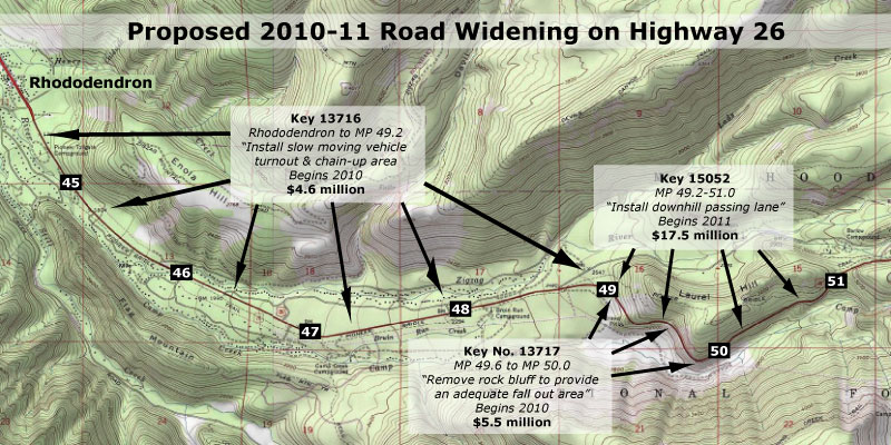
There are a total of three projects proposed for the Mount Hood corridor in this round of funding, including two “safety” projects that would widen the highway, and a third “operations” project that appears to be driven by the other two “widening for safety” proposals. The projects and their ODOT key numbers are shown on the map below.

Three projects are proposed for Highway 26 in 2010-11 that will add capacity to the road, though only if you read the fine print

(click here for a larger map)

The most alarming of the projects in this round of road widening is a proposed downhill passing lane on Laurel Hill, supposedly making it “safer” for throngs of Portland-bound skiers to pass slow vehicles on the downhill grade on busy weekends. This project is a repeat of the outmoded “widening for safety” philosophy that has already impacted the lower sections of the corridor, and was described in Part One of this article.

The ODOT project details for the “downhill passing lane” are sketchy, but such projects generally assume that drivers forced to follow slow vehicles become frustrated, and attempt to pass in an unsafe manner — a potentially deadly decision on a winding, steep mountain road. But is the answer to build a wider, faster road? Or should ODOT first use all of the other tools available to manage the brief periods of peak ski traffic before spending millions to cut a wider road into the side of Laurel Hill?

The answer to these questions seem obvious, but in fact, ODOT is moving forward with the most expensive, environmentally destructive options first, in the name of safety.

The westward view of the Laurel Hill Grade in a section proposed for widening to allow a downhill passing lane. The newly protected wilderness of the Camp Creek valley spreads out to the left.

A better solution, at least in the interim, would be to employ some of the less-expensive, less environmentally degrading approaches that have been successfully used elsewhere in the corridor. One option could be simply enforcing the current 55 mph speed limit and no-passing zones, for example, which would be much more affordable than the millions proposed to widen the highway in this difficult terrain.

Another possibility could be to extend — and enforce — the 45 mph safety corridor speed limit east from Rhododendron to the Timberline Junction, in Government Camp. Enforcing this slower 45 mph limit would result in skiers spending only an additional 90 seconds traveling the nine-mile section of Highway 26 from Government Camp to Rhododendron. This would seem a reasonable trade-off in the name of safety, especially compared to the millions it would cost to build downhill passing lanes on this mountainous section of highway.

The view east (in the opposite direction of the previous photo) where road widening is proposed to add a fourth downhill lane, carved from the sheer side of Laurel Hill.

Delaying the current road-widening proposals and taking a less costly approach to improving safety would also allow ODOT to more fully evaluate the effects that growing traffic on Highway 26 is having on the surrounding area. And while it is true that delaying a project that has already moved this far in the ODOT funding pipeline is an uphill battle, it is also true that a more fiscally conservative approach is clearly more consistent with the agency’s own transportation policy than the costly widening projects that are proposed.

However, while the visionary Oregon Transportation Plan (OTP) calls for a departure from old school thinking when it comes to new highway capacity, it does not establish a detailed vision for the Mount Hood Highway. But the general direction provided by the OTP does support a least-cost approach to managing highways, and slowing down the latest road widening proposals in the Mount Hood corridor would be consistent with that policy.

Unfortunately, the badly outdated Oregon Highway Plan (OHP) sets the wrong direction for the Mount Hood Highway, emphasizing speed and road capacity over all else. But until a better vision is in place for the highway, the response by ODOT planners and engineers to safety concerns and traffic accidents in this corridor will be more road widening projects sold as “safety improvements.”

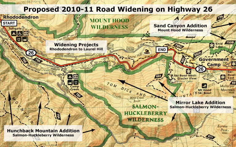
Both the Salmon-Huckleberry and Mount Hood wilderness areas saw major expansions in 2009 that were not considered in the proposed ODOT expansion projects for Highway 26

(click here for a larger map)

Over the years, this old-school approach has already created a road that is rapidly approaching a full-blown freeway in size and noise impacts on surrounding public lands. At the same time, the pressure to minimize highways impacts on the forest surroundings is still growing.

In 2009, wilderness areas around Mount Hood were significantly expanded, and the new boundaries now draw close to the highway along the Laurel Hill grade, where the “safety” widening is proposed. What will the noise impacts of the proposed highway expansion be on the new wilderness?

Already, highway noise dominates the popular Tom Dick and Harry Mountain trail inside the new wilderness, for example, more than a mile to the south and 1,500 feet above the Laurel Hill Grade. How much more noise is acceptable? How will hikers destined for these trails safely use roadside trailheads to access wilderness areas?

Nearby Camp Creek should be a pristine mountain stream, but instead carries trash and tires from the Mount Hood Highway. While it is protected by wilderness now, how will storm water runoff from an even wider highway be mitigated to avoid further degradation? How will existing pollution impacts be addressed?

The answers to these questions were not considered when this new round of “widening for safety” projects were proposed, but should be addressed before projects of this scale move to construction.

This view west along the Laurel Hill Grade shows the proximity of the new Mirror Lake wilderness additions to the highway project area.

This view east along the Laurel Hill Grade, toward Mount Hood, shows the proximity of the new wilderness boundary to the project area.

In the long term, the solution to balancing highway travel needs with protection of the natural resources and local communities along the Mount Hood corridor needs a more visionary plan to better guide ODOT decisions. Such a plan could establish an alternative vision for the Mount Hood Highway that truly stands the test of time, where the highway, itself, becomes a physical asset treasured by those who live and recreate on the mountain. This should be the core principle of the new vision.

The very complexities and competing demands of the Mount Hood corridor make it a perfect pilot for such a plan — one that would help forge a new framework for managing the highway in a sustainable way that protects both community and environmental resources.

There is also room for optimism that ODOT can achieve a more visionary direction for the corridor. The agency is showing increasing sensitivity to the way in which transportation projects affect their surroundings, as evidenced by in recent projects in the Columbia Gorge and even on Mount Hood.

To underscore this point, I chose the logo at the top of this article because it shows a re-emerging side of ODOT that understands both the historic legacy and the need for a new vision for the Mount Hood Highway that keeps the road scenic and special. After all, Oregon’s highway tradition that includes the legacy of the Historic Columbia River Highway, the Oregon Coast Highway and the amazing state park and wayside system was largely developed as an extension of our early highways. ODOT can do this simply be reclaiming what is already the agency’s pioneering legacy..

The Laurel Hill Grade on Highway 26 as viewed from a popular trail in the new Mirror Lake additions to the Salmon Huckleberry Wilderness.

The missing piece is direction from the Oregon Transportation Commission (OTC) to develop a new vision that governs how the highway is managed, and establishes desired community and environmental outcomes by which highway decisions are measured. But until a new vision for the Mount Hood Highway is in place, it makes sense to slow down the current slate of costly projects that threaten to permanently scar the landscape, and take the necessary time to develop a better plan.

If you care about the Mount Hood Highway, you should make your thoughts known on both points, and the sooner the better. The process used by ODOT to make these decisions is difficult for citizens to understand and track, especially online. So, the easiest option for weighing in is to simply send your comments in the form of an e-mail to all three tiers in the decision-making structure, using the contact information that follows.

Comments to ODOT are due by January 31, but you also can comment to the Clackamas County Commission and OTC at the same time. Contact information can be found on these links:

ODOT Region 1
(Select one of the Region 1 coordinators listed)

Clackamas County Commission

Oregon Transportation Commission (OTC)

When describing the projects, you should use the “key numbers” shown in the first map, above, as well as the project names. Simply state your concerns in your own words, but consider these critical points:

  1. The proposed Mount Hood Highway widening projects should be delayed until less-expensive, less irreversible solutions can be explored;
  2. The Mount Hood Highway needs a new vision and a better plan

Remember, these are your tax dollars being spent and your public lands at stake. You have a right to be heard, and for your voice to have an impact. With any luck, these projects can be delayed, and more enlightened approaches explored for managing our highway.

New Maps of Mount Hood and the Gorge

Mount Hood and the Columbia River Gorge were in fine company earlier this year when the National Geographic Society released a pair of new maps in their Trails Illustrated series covering both areas. This map series is generally limited to national parks, so the few outstanding areas outside the National Park System (NPS) included in the set read like a who’s who of places that should be made into national parks or recreation areas.

NatGeo01

For locals already familiar with these areas, the new maps feature surprisingly accurate, up-to-date information on trails, campgrounds, forest roads and — most impressively — the many new and expanded wilderness areas that were legislated this year with the new Mount Hood wilderness bill. This information, alone, makes them a worthy addition to your map collection.

As with any National Geographic map, the cartography is lush, and containes a wealth of details. One example are Bureau of Land Management (BLM) and Oregon State Forest (OSF) lands that are helpfully mapped where they abut national forest boundaries. But most importantly, the new maps show numbered forest trails on a backdrop of contour lines an relief shading, making for an excellent trip planning tool or handy map for the field.

The Mount Hood map (No. 820) extends from Lost Lake south to the edge of the Mount Jefferson Wilderness, and from Table Rock on the west to the Warm Springs reservation on the east. New, expanded boundaries for the Mount Hood, Badger Creek, Bull of the Woods and Salmon Huckleberry Wilderness Areas are shown, and are interesting to study for those who have only seen the new wilderness legislation on cryptic web maps.

NatGeo02

This detail of the Cloud Cap area includes a note about the washed-out Eliot Branch crossing on the Timberline Trail

The Mount Hood map also includes the newly created Clackamas and Roaring River wilderness areas, the new “Mount Hood National Recreation Area” (a new designation adjacent to Badger Creek Wilderness) and the various new additions to the Wild and Scenic River system. Map blurbs provide travel information, area history and surprisingly detailed specifics on each of the wilderness areas that will be valuable to visitors exploring the area.

The Columbia Gorge map (No. 821) extends from Troutdale east all the way to the Deschutes River, encompassing the entire Columbia River Gorge National Scenic Area. The map also extends from Lost Lake on the south well into the Gifford Pinchot country north of the river, incorporating a good portion of the Indian Heaven Wilderness and all of the Silver Star Mountain backcountry.

Like the Mount Hood map, the Gorge map includes trail and travel information, map blurbs with travel information, area history, details on popular destinations within the Gorge and depicts the new wilderness boundaries resulting from the recent Mount Hood wilderness legislation.

NatGeo03

This except from the new Roaring River Wilderness shows the new boundaries in green, and the new Wild and Scenic River designation for the South Fork Roaring River

Both maps are printed on waterproof paper for use in the field, and measure approximately 4.25″ x 9.25″ folded, fitting neatly into a coat pocket or backpack. Both are at a scale of 1:75,000, which is a bit small for some hikers, but has the advantage of being a great travel planning map – or just a nice way to explore those new wilderness areas from the comfort of your traveling armchair. Each map retails for about $12 directly from National Geographic or from online book sellers.

Tiny Timberline Survivors

TinyTimberline00

Bright yellow Sulphur Flower carpet the slopes below Palmer Glacier in August

During the peak of summer in the high country around Mount Hood, hikers flock to the lush mountain meadows in places like Paradise Park, Cairn Basin, Elk Cove and Elk Meadows to take in the huge drifts of waist-deep wildflowers. Along the way, they usually pass through the cinder slopes and glacial moraines that seem barren in comparison, but in fact are home to some of the toughest survivors of the wildflower community.

These diminutive flowers are incredibly rugged, resilient plants that somehow manage to persist in the harshest of alpine environments, cheerfully blooming each August during a snow-free growing season that spans only three or four months. Most are perennials, persisting from summer to summer, despite a thick snow pack for much of the year.

Their tiny size is but one of their adaptations to the extreme conditions that exist above the tree line. Most also feature long taproots that anchor them deep in the loose mountain soil, and thick, leathery leaves that help conserve water while maximizing photosynthesis during the very short growing season.

There are a number of tough species in this community of survivors, but the following are seven that are among the most common and interesting, and worth getting to know. These plants were all photographed on the same August evening, high on the south slopes of Mount Hood.

TinyTimberline01

Creeping Penstemon (Penstemon davidsonii)

Creeping Penstemon
This tiny flower grows just six inches tall, though its woody stems are almost shrub-like, and allow the plants to form carpets several feet across, usually on the protected side of a boulder. The oval, evergreen leaves are small and leathery, and also seem almost shrub-like, resembling tiny rhododendron leaves. The flowers can range in hue from lavender to nearly pink, and bloom in short spikes in early and mid-summer.

TinyTimberline02

Desert Parsley (Lomatium martindalei)

Desert Parsley
This little plant (also called Few-Fruited Desert Parsley) also grows in loose sand or pumice at the tree line, and is anchored by a large taproot that can up to a foot long. The thick roots of wild parsleys were collected by Native Americans as a food. Desert Parsley is most notable for its graceful, fernlike leaves, but also sports bright yellow blossoms in mid-summer. The plant is rarely more than four or five inches high.

TinyTimberline03

Low Mountain Lupine (Lupinus lepidus)

Low Mountain Lupine
This wonderfully tiny lupine is an obvious cousin to its many tall relatives, except that it grows no more than three or four inches tall. The tiny leaflets resemble the large, palmate leaves of larger lupines, except that they are the size of a button. The leaves are also covered in soft, silvery velvet that further helps the plants conserve water. The plants are anchored by a long taproot, like most alpine dwarfs. Their blossoms are globe-shaped, like a clover, though clearly related to the tall flower spikes of their larger cousins. Low Mountain Lupine blooms from early August through early September.

TinyTimberline04

Partridge Foot (Luetkea pectinata)

Partridge Foot
This delicate plant can form an extensive groundcover below timberline, but also blankets moist spots in the harsh country above the tree line, especially where melting snow trickles in small streams across rocky slopes. Partridge Foot is only a few inches tall, with creamy white flower spikes reaching 3-4 inches in mid-summer. The common name comes from the shape if its leaves, which apparently resemble a bird’s foot.

TinyTimberline05

Pussypaws (Spraguea umbellate)

Pussypaws
This tiny wildflower also has a self-evident common name, owing to the soft, fleshy, paw-shaped leaves that help the plant store moisture in its harsh habitat. In mid-summer, Pussypaws are covered with tufts of pom-pom flowers that open white, then fade to rose-pink. These little plants are no more than two inches high, with flower stems reaching three or four inches. It thrives in nearly soil-less pumice, and has an amazing taproot that can be as long as ten feet!

TinyTimberline06

Spreading Phlox (Phlox diffusa)

Spreading Phlox
Easily the lowest alpine flower, Spreading Phlox grow in a mat just 1-3 inches high, with their stunny explosion of cheery blossoms literally covering the plants in early August. The button-like flowers range from white to blue, with all shades of pink and violet between. Like its alpine neighbors, Spreading Phlox is deeply rooted, and thus well adapted to the dry, loose pumice and sandy slopes that it thrives in.

TinyTimberline07

Suphur Flower (Erigonum umbellatum)

Sulphur Flower
Also known as Sulphur Buckwheat, this is a tough survivor that lives in the least hospitable reaches of the alpine environment. This plant has silvery leaves covered with tiny hairs that help conserve moisture, allowing the plants to grow in what seem to be impossible habitats — from cracks between rocks and in loose scrabble on moraines. The flowers can range from cream to yellow, and light up slopes in early summer, before fading to a rosy hue. The top photo in this post shows a colony of Sulpher Flower on Mount Hood’s dry south slopes.

How to See Them
These timberline survivors can be seen all around Mount Hood, and on some of the higher surrounding peaks, too, such as Lookout Mountain and the high spots in the Columbia Gorge that reach above the tree line.

An easy way to see these plants up close is to explore the trails around Timberline Lodge. Several paved footpaths circle the lodge, and head up the mountain from the back of the lodge. You can follow one all the way to Silcox Hut, which is located far above the tree line, but still features many of these tiny flowers along the way.

Another option from Timberline is to follow the Pacific Crest Trail (PCT) south from the lodge, crossing the glacial headwaters of the Salmon River then to an impressive overlook of the White River canyon. This section of the PCT is lined with these tiny alpine survivors. Visit these trails in early August, and you’re guaranteed to see them in bloom.

The Mount Hood Lily

MountHoodLily01

Second only to our towering Pacific rhododendron (Rhododendron macrophylum) in pure spectacle, the striking white trumpets of the Mount Hood lily are unforgettable. These handsome lilies often grow to more than six feet in height with as many as 20 flowers, each up to 8 inches in length. Never heard of the Mount Hood lily? That’s probably because you know this as the Washington lily (Lilium washingtonianum Kellogg), though it is also widely known as the Cascade lily and Mount Hood lily. A slightly variant race of the species in Northern California is commonly called the Shasta lily.

But the rather generic name of “Washington lily” is made more confusing by the simple fact that this beautiful plant doesn’t even grow in the state of Washington. Its northern extent is the area around Mount Hood, and its range extends down the Cascades and into the California Sierras. But thankfully, it turns out that the lily wasn’t named for the State of Washington, at all. Instead, the naming pre-dates Washington statehood.

In fact, botanist Albert Kellogg named this regal flower for Martha Washington, wife of our first president, when he first described the species in 1859. The spectacular, aromatic plants were soon collected for gardens and picked by forest visitors, locally decimating the population by the 1950s. Today, they have made a comeback, and are relatively common across their range, especially around Mount Hood.

Martha Washington and a Nineteenth Century rendering of our western lily named in her honor

Martha Washington and a Nineteenth Century rendering of our western lily named in her honor

Like most lilies, the Mount Hood Lily is a perennial that grows from a bulb, and thus the ease in collecting the species for commercial use. Native Americans also collected the bulbs as a food source. The plant grows in open woodlands and forest openings, often in surprisingly dry conditions.

In addition to multiplying their bulbs over time, the plants produce up to 200 seeds in the capsules that follow each flower. While digging the bulbs is strongly discouraged, collecting the seeds to grow in home gardens is a responsible, sustainable means of propagating the plants. Collected seeds of the native species, as well as many hybrids, are also available from specialized retailers.

So, in the spirit of provincialism, I propose that we rename this plant, simply because of the confusion over the name — after all, Kellogg named the plant in the year in which Oregon became a state, so he was likely unaware that another state in the Northwest would be named for George Washington.

There’s also the fact our first First Lady already has the aristocratic series of Martha Washington Geraniums (Pelargonium domesticum) named in her honor, and thus adding the Mount Hood lily is a mere asterisk in comparative prominence. Besides, Martha Washington has already had three postage stamps, two early dollar bills, several U.S. Mint commemorative coins and the only U.S. naval ship — the U.S.S. Lady Washington — to be named for a first lady.

As a modest and proper woman in the tradition of her time, surely she would cringe at this embarrassment of honors? And as the chief overseer of the Mount Vernon plantation and a gardener herself, surely Martha Washington would be the first to agree that the Mount Hood lily is a far superior name, both in descriptiveness and clarity?

This leads us to another simple compromise: when she tended to troops at General Washington’s side in the desperate struggle at Valley Forge, Martha Washington became known as Lady Washington, and a true heroine in her time. So, perhaps the Lady Washington lily would be a proper solution to our naming dilemma?

Where the heck is Tamarack Rock?

TamarackRock01

You won’t find Tamarack Rock on any maps, though this rugged knoll is hidden in plain sight — just off the Surveyors Ridge Road (FR 17) on the east side of Mount Hood. The rock didn’t get much respect during the logging heyday of the late 1900s, with gravel spur roads wrapping almost entirely around the rock, and big ponderosa trees felled from its gentle southern flank.

But through all the destruction that reigned here, a lone Western larch tree survived in a most unlikely spot, among the huge boulders near the crest. The tree is among the most magnificent of its kind in the area, a massive, gnarled, determined old sentinel that has managed to dodge lightning strikes and fires, as well as chainsaws.

Mount Hood at dusk from Tamarack Rock

Mount Hood at dusk from Tamarack Rock

The view from the rock is glorious, with the broad northeastern face of Mount Hood towering over waves of forest ridges, and the tiny farms and orchards of the Upper Hood River Valley, spread far below. The forested Mill Creek Buttes complete the scene, to the east. The scenery is so sweeping that it’s easy to forget the maze of logging roads and clearcuts all around. In this way, Tamarack Rock survives, surprisingly intact.

A birds-eye view of Tamarack Rock

A birds-eye view of Tamarack Rock

I had passed the rock countless times over the years, always promising myself that I’d explore this postage-stamp wilderness someday. This spring, I finally made good on the promise, and explored the landmark from all sides. Trail riders and hikers are already familiar with the rugged west face of the rock, where it towers above the popular Surveyors Ridge Trail. From this angle, the rock has a “face”, which in turn led to a spirited discussion among the PortlandHikers.org community on just what to call the rock — if it didn’t already have a name.

The "face" of Tamarack Rock from the Surveyors Ridge Trail.

A quick survey of those familiar with the area didn’t reveal a local name for the rock, so I posted a survey on PortlandHikers.org to poll a few options. When the votes were counted, the uncanny resemblance of the “face” to a certain Hollywood film director won the day, and it appeared that this landmark might become “Hitchcock Rock” to recreationists. Fortunately, the story didn’t end there, though it led to some creative photo interpretations (see below).

The backup filming location for "North by Northwest", perhaps?

This is where the PortlandHikers.org discussion sent me back to the rock, because it was unclear from my early photos whether the ancient tree near the crest was living, dying or dead — or simply a larch in dormant winter phase, sans needles. My second visit a few weeks later revealed a fresh burst of new needles covering the old giant, and redirected the naming discussion to the tree in question.

Given the proximity of Larch Mountain (and other features) using the larch as namesake, the PortlandHikers.org consensus was to fudge a bit by using the “tamarack” name, instead. This is botanically incorrect, but as we learned in our debate on the subject, a good portion of the west actually uses the name “tamarack” to describe Western larch, and it had a nice ring to it, besides: Tamarack Rock!

I wasn't the first to the top, and surely won't be the last..!

I wasn't the first to the top, and surely won't be the last..!

On this follow-up visit to the rock, I also discovered a long history of visitors, beginning with a geocache box tucked into an inconspicuous hiding spot. The journal inside listed a visitor earlier the same day, remarking on a “large coyote” seen near the rock. Other visitors simply commented on the impressive views.

Not far from the geochache were a couple of homemade memorials, honoring Adam J. Dietz Sr. (1917-1997) and Alfred West (1910-1998). Clearly, these two gentlemen had some connection with the rock, but for now, I can only assume they worked or hunted in the forest, and might have been local to the area. But their presence further cemented the idea of a more respectful name for the rock, no matter the Hitchcockian resemblance.

The rustic Adam J. Dietz Sr. Memorial on Tamarack Rock

The rustic Adam J. Dietz Sr. Memorial on Tamarack Rock

Yet the human history of Tamarack Rock seems to go back even further, and perhaps by millennia: a few yards from the aluminum Alfred West memorial cross, there are at least two, and possibly three Native American ceremonial pits. One is quite obvious, a second somewhat compromised and a third barely visible. The pits are located in full view of the mountain, and mimic similar pits in the area, including this subject of an earlier post.

Finding all this human history in gathering twilight on that brisk spring evening was exhilarating, to say the least. It was yet another reminder that we are all just passing through, and how we treat this land will be our only real legacy. Tamarack Rock has clearly been admired and loved for generations, and how fortunate we are that the even the era of road building and forest destruction didn’t destroy this unique place.

In another century, there’s a good chance the old larch tree will still live, clinging to this rock, long after we’re gone. If the old tree does survive, it will be a pretty good measure of our collective will to leave the Mount Hood country in better shape than we found it. It will also reflect our human capacity to honor places like this simply because of their spiritual significance to those who came before us.

I think we’re up to that challenge.

New Glaciers on Mount Hood?

WhiteRiverNewGlacier01

It seems implausible, but climate change may be creating new glaciers on Mount Hood — but not in the usual way that glaciers are created. A close look at the retreating White River Glacier on the sunny south flank of Mount Hood reveals two stranded arms that are now separate glacier. As marked by (1) and (2) on the photo, above, a pair of truncated mini-glaciers have been cut off from the main flow of the White River Glacier by a previously hidden moraine that is now being exposed by the rapidly retreating ice.

Until fairly recently in geologic time, the White River Glacier extended far beyond its current extent, flowing down the rugged canyon shown in the photo for several miles to a terminus far beyond where Highway 35 now crosses the glacial outwash plain. But the glacier is retreating rapidly, destabilizing the canyon and changing its shape as it shrinks.

A closer look at two mini-glaciers on Mount Hood

A closer look at two mini-glaciers on Mount Hood

A closer look at the two mini-glaciers reveals why a glacier is different from a static field of ice. Glaciers flow under their own weight, sending waves of ice sliding downward as more snow is added, above. Huge cracks known as crevasses form at stress points in the river of ice, and these are a defining feature in identifying a glacier. Both of these sheets of ice have crevasses, and thus are moving glaciers.

A look at the topographic map shows how the extent of the White River Glacier has changed as recently as the 1960s, when the map was surveyed. The mini-glacier marked as (1) was clearly an arm of the White River Glacier until very recently, but surprisingly, the second mini-glacier (2) appears to already have separated from the main glacier before the surveys were done — though it is clearly a truncated lobe of the main glacier, as well.

WhiteRiverNewGlacier03

Another defining feature for this pair of mini-glaciers is that the emerging moraine that divides them from the main glacier also divides their outflow. They feed a separate branch of the White River from the main stem – another argument for recognizing these glaciers as discrete, perhaps?

It is logical to assume that these little glaciers are doomed by the same forces of climate change that created them, but there is a twist that just might keep them flowing — and perhaps thriving — as a result of climate change. While scientists believe that snow levels will rise in the Cascades over the next century, they also believe that precipitation will increase.

That could mean that in the highest elevation areas where winter precipitation still falls mainly as snow could actually see glaciers grow in depth, but perhaps not in length, since freezing levels would be higher. Therefore, if these mini-glaciers are high enough on the mountain, they may well survive, or possibly even grow, thanks to increased snowfall at this elevation.

If these glaciers are new, and independent of the White River Glacier, they deserve some respect, since all known glaciers in Oregon have been formally named. And that brings us to a bit of history surrounding this flank of the mountain. For here, on the upper slopes above these little glaciers, the first attempts on Mount Hood’s summit were made by early white settlers.

A close-up view of the mini-glaciers reveals classic crevasses

A close-up view of the mini-glaciers reveals classic crevasses

The first man in this story is Thomas Jefferson Dryer, the colorful publisher of the Weekly Oregonian in the mid-1800s (pictured below, on the left). Dryer claims to have been the first white man to climb the mountain, in August 1854. Dryer’s description of the climb makes it clear that he did not reach the true summit, though he may well have reached the top of the Steel Cliffs, only a few hundred feet below the summit — and an amazing achievement for the day.

Dryer complicated his case by embellishing the story with outrageous exaggerations — being able to see Mount Shasta (not possible) and peaks in the Rockies (definitely not possible), and his climbing companion bleeding form his skin from the extreme altitude (not very likely). But Dryer was also the first white man to climb Mount St. Helens, so his story must be taken with some degree of faith.

Dryer’s account wasn’t challenged until three years later, when one of his employees, Henry Lewis Pittock, made the first documented ascent of Mount Hood on August 6, 1857. The Pittock party made the climb along what is now the traditional southern route, skirting the west edge of the White River Glacier, and climbing through the crater. When Pittock’s party made claim to being the “first” to summit the mountain, it set off a dispute with Dryer over the veracity of his own account that continues to this day.

Thomas Jefferson Dryer (left) and Henry Lewis PIttock

Thomas Jefferson Dryer (left) and Henry Lewis PIttock

In 1861, Dryer was tapped to serve in the Lincoln administration, and turned the Weekly Oregonian over to Pittock, to whom he owed a significant debt in the form of back pay. Pittock, in turn, converted the weekly into a daily and was soon publishing the predominant newspaper in the region, today’s daily Oregonian.

Pittock is now recognized as the first white man to summit Mount Hood, but like Dryer, doesn’t have a landmark in his name to record his place in history (though Portlanders are quite familiar with the iconic mansion he built atop the West Hills).

So I offer a modest proposal: honor both men for their historic climbs, with the western mini-glacier (1) named for Pittock, representing his more westerly approach, and the eastern mini-glacier named for Dryer, who may have even walked on this ice sheet in his own attempt at the summit. Both men deserve to be remembered for their part in Mount Hood’s history, and these little glaciers deserve some respect, too.

Parkdale Lava Flow

The dark wall formed by the Parkdale Lava Flow rises abruptly from the famous fruit orchards of the Hood River Valley

The dark wall formed by the Parkdale Lava Flow rises abruptly from the famous fruit orchards of the Hood River Valley

Tourists will soon be streaming into the Hood River Valley to marvel at the pink and white blossoms that blanket Oregon’s most famous apple and pear orchards each spring, with snowy Mount Hood towering above.

For many, the trip takes them to the tiny farm hamlet of Parkdale, in the heart of the upper valley. Here, the unexpected view of a dark wall of lava known as the Parkdale Lava Flow is a surprise to even longtime Oregonians. This dramatic flow is among the largest and youngest in the Cascades, yet remains surprisingly unknown.

This Google Earth view looks south, from the toe of the Parkdale Lava Flow, toward its origin, at the foot of Mount Hood

This Google Earth view looks south, from the toe of the Parkdale Lava Flow, toward its origin, at the foot of Mount Hood

From the farms near Parkdale. the lava flow looks like a ridge of jumbled boulders, with the occasional Douglas fir or ponderosa pine poking out of the chaos. But viewed from above, the formation takes on a more recognizable form. Flowing north from a deep fissure at the foot of Mount Hood, the lava first poured down the valley in a single, broad stream, pushing the Middle Fork of the Hood River from its channel.

As the river of molten rock reached the flats of the upper Hood River Valley, the lava began to spread out from the river channel, with great lobes spilling sideways from the main flow onto the valley floor. By the time the eruption was over, the lava had traveled more than four miles, and poured more than 390 million cubic yards of molten rock on the surface. That’s 4 million dump truck loads of lava, and when the lava cooled, it covered nearly 3,000 acres to depths as much as 300 feet.

Aerial views show giant ripples and lobes in the Parkdale lava flow, and the displaced Middle Fork Hood River, flowing along the edge of the new lava

Aerial views show giant ripples and lobes in the Parkdale lava flow, and the displaced Middle Fork Hood River, flowing along the edge of the new lava

The Middle Fork of the Hood River must have been a hellish sight when the eruption occurred, as molten rock filled the stream bed, and vaporized both river and forest as it overwhelmed the landscape. Today, the river traces the west margin of the flow (shown on the right in the image above), with lava slopes rising steeply from the stream. This rugged terrain along the Middle Fork makes for one of the least-visited sections of river anywhere in the Mount Hood region.

The Parkdale Lava Flow is young by geologic standards at just 7,000 years old. That places the eruption at about the time when Crater Lake was formed, following the massive eruption and collapse of the former Mount Mazama.

The Parkdale Lava Flow falls partly into private ownership

The Parkdale Lava Flow falls partly into private ownership

Geologists note that the Parkdale flow overlays traces of Crater Lake ash deposited in the Mount Hood area, suggesting that the lava flowed just after the destruction of Mount Mazama. This puts both events within the period when the first Native Americans were living in the region, and we can only imagine how the ensuing chaos must have impacted these early residents.

Since the eruption 7,000 years ago, a few trees have pioneered the lava flow, mostly along shaded side slopes, but it mostly looks like it erupted very recently. As might be expected, the flow is also home to small wildlife that thrive in the shelter that the jumbled rock provides. Through sheer luck, the flow was never mined for aggregate, despite its proximity to huge construction projects, such as the dams and highways in the nearby Columbia River Gorge.

The Forest Service has designated 854 acres of the Parkdale Lava Flow as a geologic “Special Interest Area” for the stated purpose of “public recreation use, study and enjoyment.” In its forest plan, the agency has committed to managing such areas in a natural condition, pending a detailed implementation plan for each area. This is where the Parkdale Lava Flow stands today.

Part of the lava flow, along the northeast corner (see map), is on private land. While this private land is already inside the Mount Hood National Forest jurisdictional boundary, the agency rarely acquires land thanks to lack of dedicated funding or a clear mission on which lands ought to be acquired. So for now, this is yet another unique natural feature at risk of development.

In the long term, the Mount Hood National Park Campaign envisions bringing the L-shaped piece of private land into public ownership, and providing recreational and interpretive access to the area. Until that day, the area can be explored off-trail, with access from adjacent forest roads.

Restoring Celilo Falls

Celilo Falls has always been phantom of history to me, since I born a few years after the U.S. Army Corps of Engineers buried the falls behind The Dalles Dam in 1957. My understanding of the falls and the loss it now represents has come from old photos and maps, and a few shaky film images.

The railroad bridge in the background of this iconic view is the key to locating the falls today

The railroad bridge in the background of this iconic view is the key to locating the falls today

Yet for many, the falls and the native culture surrounding them are alive and vibrant in their memories, thanks to seeing and experiencing them first-hand. For Native Americans, the vivid memories only add to the pain of losing a place that quite literally defined a people for millennia.

The idea of restoring the falls — even temporarily — has been suggested over the years, usually to be slapped down quickly by the Corps of Engineers as unfeasible, or even dangerous. In the late 1980s, a brief, 30th anniversary movement to temporarily draw down the pool behind the dam briefly gained local momentum before the federal agencies killed any talk of the idea. The Corps likely realized that revealing the falls to the public even once could make it politically impossible to ever refill the dam again.

This 1940s aerial view shows the falls and railroad bridge, looking south

This 1940s aerial view shows the falls and railroad bridge, looking south

The hostility of the federal agencies toward even acknowledging the falls fanned the rumors among the local tribes that the falls had, in fact, been purposely destroyed by the Corps of Engineers just before they were inundated. This rumor persisted until last year, when a new mindset among Corps managers spurred the agency to compile a comprehensive sonar map of the falls to show that they are quite intact, beneath the still surface of the reservoir.

The sonar confirmation of the intact falls has breathed new life into the hopes of many that the falls will not just someday be restored, but perhaps someday soon. This is where the restoration of Celilo Falls fits within the scope of the MHNP Campaign: the emerging environmental theme in the coming century is restoration, and no place in the Pacific Northwest is more deserving — perhaps even the nation, considering that 11,000 years of Native American culture at Celilo makes it the oldest continuously settled place in North America.

This map clip correlates today's landmarks to the aerial view of the falls, above

This map clip correlates today's landmarks to the aerial view of the falls, above

But the connection to Mount Hood is even more elemental: the mountain towers over the Celilo country like a beacon, and has been a similarly important feature in the culture of Lower Columbia tribes. Celilo and WyEast are connected, and so their restoration should be. A joined effort to heal these places expands the possibilities for both.

What will a restored Celilo Falls look like? Initially, it will likely be mineral-stained and muddy. But the new sonar maps confirm that silts have not overtaken the falls, so if the pool behind The Dalles Dam were simply lowered today, we would see a largely intact falls — perhaps even with traces of the cantilevered dip net fishing structures that once clung to the rocks around the falls. And over time, the falls would quickly recover to blend again with the surrounding landscape.

R. Swain Gifford's 1875 etching of Mount Hood towering over the Celilo Narrows is among the earliest geographically accurate renderings of the area

R. Swain Gifford's 1875 etching of Mount Hood towering over the Celilo Narrows is among the earliest geographically accurate renderings of the area

What would a restored Celilo Falls mean for the mid-Columbia economy? The immediate impact would be on power supplies, and it is unlikely that the falls could ever be restored without some alternate energy supply — perhaps a wind farm of equal wattage? — ensuring that no net loss in energy production would result.

The next big question would be impacts on shipping, but the good news here is that barges were already using the Celilo Canal to bypass the falls long before the dam was erected. The canal system would conceivably resume this function, if the falls were reborn, albeit with likely improvements and modernization.

These scene was photographed in the mid-1950s, just before the falls was inundated

These scene was photographed in the mid-1950s, just before the falls was inundated

What kind of protection should the restored Celilo Falls receive? That part is easy. The astonishing scope of history tied to the falls easily qualify the site for World Heritage status within the U.S. National Park System, perhaps as a National Historic Site. This would put the restored falls in a category with places like Mesa Verde, in Colorado, and provide the needed framework to preserve and understand the historic resources that lie beneath today’s reservoir.

Restoration of Celilo Falls is a long-term dream of so many, but movement in that direction really began as soon as the falls disappeared in 1957. The falls has never left our collective consciousness, and thus demands restoration.

Another small step toward restoration will occur in 2009, when the commemorative Confluence Project will bring an art installation to Celilo. The project is marking the two centuries since Lewis and Clark passed through the region, and the millennia of human history that makes Celilo unique. A small step, but also a bit more progress toward what I believe will be the inevitable restoration of Celilo Falls — under the gaze of a restored Mount Hood.