After the Fire: What Recovery Looks Like

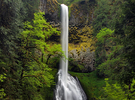
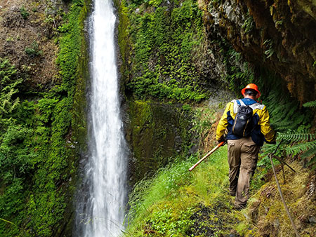
PCTA trail volunteers at Tunnel Falls in July (Photo: Nathan Zaremskiy)

Rock-star trail volunteer (and friend of the WyEast Blog!) Nate Zaremskiy has shared another update on the forest recovery in the upper Eagle Creek canyon, at the heart of the 2017 Eagle Creek Fire in the Columbia River Gorge (see Nate’s first batch of images in this earlier blog article). Nate captured these images in July as part of a Pacific Crest Trail Association (PCTA) trail stewardship effort to continue restoring the Eagle Creek trail.

We’ll start with a visual rundown of some of the waterfalls that draw hikers to Eagle Creek from around the world. First up is Sevenmile Falls, a lesser-known falls at the head of the series of cascades on Eagle Creek. The fire was less intense here, with some of the forest canopy and intact and riparian zone along Eagle Creek rebounding quickly (below).

Fire recovery at Sevenmile Falls (Photo: Nathan Zaremskiy)

Moving downstream, the area around spectacular Twister Falls is recovering more slowly. The fire burned intensely on the rocky slopes flanking the falls, though many trees in the riparian strip upstream from the falls survived the fire (as seen in the distance in the photo, below).

Fire recovery at Twister Falls (Photo: Nathan Zaremskiy)

Tunnel Falls (opening photo) appears almost as if there had never been a fire, with the cliffs around the falls green and verdant. But a wider view of this spot would show an intensely burned forest above the falls that is only beginning to recover, as we saw in Nate’s earlier photos.

Continuing downstream, the next waterfall in the series is Grand Union Falls, a thundering just below the confluence of the East and main forks of Eagle Creek. The forest here largely dodged the fire, with many big conifers surviving along the stream corridor (below).

Restored “basalt ledge” trail section above Grand Union Falls (Photo: Nathan Zaremskiy)

The handiwork of the PCTA crews can be seen in the above view of the infamous “basalt ledge”, where the Eagle Creek Trail is blasted uncomfortably through solid basalt columns along a sheer cliff face. The fire triggered a cliff collapse here, burying the trail in tons of rock. Over the past several months, PCTA volunteers meticulously cleared this section of trail, tipping huge boulders over the edge on at a time.

Nate’s photo update of the upper waterfalls ends here, but his new images also reveal an encouraging recovery underway in the burned forests of the upper Eagle Creek canyon. In moist side canyons the understory is rebounding in abundance, with familiar forest plants like Devils club, Sword fern and Lady fern covering the once-burned ground (below).

Lush understory recovery in a moist side canyon on the upper Eagle Creek Trail (Photo: Nathan Zaremskiy)

Along other, drier canyon slopes Fireweed (or “Firestar”? See “A Rose by any other name” on this blog) has exploded on the landscape, blanketing the burned soil as would be expected from this ultimate pioneer in forest fire recovery. Nate and his volunteers were sometimes shoulder-deep in Fireweed as they hiked along the upper sections of the Eagle Creek Trail (below).

Fireweed leading the recovery on the upper Eagle Creek Trail (Photo: Nathan Zaremskiy)

Shoulder-high Fireweed on the upper Eagle Creek Trail (Photo: Nathan Zaremskiy)

In other parts of the burn, the unburned roots and stems of the understory that survived the fire underground are now pushing new growth above the burned soil. Even in areas where no trees survived the flames, understory survivors like Vine Maple, Thimbleberry and Oregon grape can be seen in abundance in views like this (below):

Recovering understory in a heavily burned section of the upper Eagle Creek canyon (Photo: Nathan Zaremskiy)

Even the most intensely burned areas in the upper reaches of the Eagle Creek canyon are showing signs of life, with Oregon Grape, Salal and Ocean Spray emerging from roots that survived beneath the ashes (below).

Recovery is slower in the most intensely burned areas, but is still underway (Photo: Nathan Zaremskiy)

The forest recovery in the Eagle Creek burn is just beginning a cycle that has played out countless times before in Western Oregon forests, especially in the steep, thin-soiled country of the Columbia River Gorge. So, what can we expect as the recover continues to unfold? It turns out we have a good preview of things to come with a pair of recent burns in the Clackamas River canyon, fifty miles to the south, where the forests and terrain are very similar to the Gorge.

What’s next? Learning from the Clackamas Fires

Two recent fires have swept through the steep-walled canyon of the lower Clackamas River. In 2014, the 36 Pit Fire burned 5,524-acres in the canyon. This was a scary September blaze that drew required 1,000 fire fighters to contain the fire from burning utility lines and toward homes near the town of Estacada. The 36 Pit Fire burned much of the South Fork Clackamas River canyon, a newly designated wilderness area, as well as several miles of the main Clackamas River canyon.

Forest recovery following the 36 Pit Fire the Clackamas River Canyon

Like Eagle Creek, the 36 Pit Fire burn was the result of careless teenagers, in this case started by illegal target shooters. Five years later, this gives us a look at what the Eagle Creek burn will look like in another 3-4 years. The view below is typical of the 36 Pit Fire, with broadleaf understory species quickly recovering in the burned canyon.

In this view (below) a trio of maples — Bigleaf maple, Douglas maple and Vine maple — dominate the recovery along a canyon slops. Most are growing from the surviving roots of trees whose tops were killed in the fire. This ability to recover from surviving roots gives broadleaf trees a leg up over conifers like Douglas fir.

Five years of slope recovery after the 36 Pit Fire

Another scene (below) from the canyon floor shows how areas with more ground moisture have fared five years after the 36 Pit Fire. Here, the conifer overstory largely survived the fire, and even some of the broadleaf trees have survived, in part because the were less drought-stressed than trees higher up the slopes when the fire swept through. This is typical of burns and can be seen throughout the Eagle Creek burn, as well, with well-hydrated trees in moist areas better able to withstand the intense heat of the fire.

Here, Bigleaf maples on either side of the view are sprouting new growth from midway up their partially burned trunks. These damaged trunks of these trees may not survive over the long term, but most are also sprouting new shoots from their base — an insurance policy in their effort to survive. The understory throughout this part of the canyon floor is exploding with new growth from roots that largely survived the fire and benefit from the moisture here in their recovery. Thimbleberry (in the foreground) is especially prolific here.

Understory growth has exploded along the moist canyon floor

The following scene (below) is also typical of the 36 Pit Fire at five years, with the conifer overstory mostly surviving the fire on this low slope, and the understory rejuvenated by the burn. When scientists describe a “beneficial” fire, this is an example of the benefits. Beneath the surviving conifers in this view, the white, skeletal trunks of burned Vine Maple and Red alder rise above vibrant new growth emerging from the roots of these trees. This lush new growth provides browse for deer, elk and other species, and new habitat for small wildlife, while also protecting the steep forest soils from erosion.

Vine maple emerging from surviving roots of tops killed by the 36 Pit Fire

In September 2002, the much smaller Bowl Fire swept through 339 acres of mature forest along the west end of the Clackamas River Trail, just upstream from Fish Creek. Like the Eagle Creek and 36 Pit fires, the relatively small Bowl Fire was human-caused, with the ignition point along the Clackamas River Trail, likely by a hiker. More than 300 firefighters were called out to fight this blaze.

Fifteen years of recovery has transformed the canyon slopes burned in the Bowl Fire from black to lush green

Today, The Bowl Fire provides a look 15 years into the future for the Eagle Creek burn, and the rate of recovery here is striking. These views (above and below) from the heart of the Bowl Fire show 20-25 foot Bigleaf maple and Red alder thriving among the surviving conifers and burned snags. Vine maple, Douglas maple, Elderberry and even a few young Western red cedar complete this vibrant scene of forest rejuvenated by fire.

The forest recovery from the Bowl Fire give us a glimpse of what the burned areas of the Gorge will look like in another 10-12 years

Growing up in Oregon, I was taught that many of these broadleaf tree species that are leading the fire recovery in the Clackamas River canyon and at Eagle Creek were “trash trees”, good for firewood and little more. But as our society continues our crash course in the folly of fire suppression and ecological benefits of fire, these species are emerging as hard-working heroes in post-fire forest recovery.

The Unsung Heroes of Fire Recovery

It’s worth getting to know these trees as more than “trash trees”. Here are five of the most prominent heroes, beginning with Bigleaf maple (below). These impressive trees are iconic in the Pacific Northwest, and highly adaptable. They thrive as towering giants in rainforest canyons, where they are coated in moss and Licorice fern, but can also eke out a living in shaded pockets among the basalt cliffs of the dry deserts of the eastern Columbia River Gorge. Their secret is an ability to grow in sun or shade and endure our summer droughts.

Forest recovery hero: Bigleaf Maple

As we’ve seen in the Gorge and Clackamas River canyon burns, Bigleaf maple roots are quite resistant to fire. Throughout the Bowl Fire and 36 Pit Fire, roots of thousands of burned Bigleaf maple have produced vigorous new shoots from their base, some of which will grow to become the multi-trunked Bigleaf maple that are so familiar to us (and providing some insight into how some of those multi-trunked trees got their start!). Their surviving roots and rapid recovery not only holds the forest soil together, their huge leaves also begin the process of rebuilding the forest duff layer that usually burns away in forest fires, another critical role these trees play in the fire cycle.

Vine maple (below) are perhaps the next most prominent tree emerging in the understory of the Bowl Fire and 36 Pit Fire. Like Bigleaf maple, they emerge from surviving roots of burned trees, but Vine maple have the added advantage of a sprawling growth habit (thus their name) when growing in shady forest settings, and these vine-like limbs often form roots wherever they touch the forest floor. When the exposed limbs are burned away by fire, each of these surviving, rooted sections can emerge as a new tree, forming several trees where one existed before the fire. Vine maples are abundant in the forest understory throughout the Cascades, so their survival and rapid recovery after fire is especially important in stabilizing burned slopes.

Forest recovery hero: Vine maple

Douglas maple (below) is a close cousin to Vine maple and also fairly common in the Clackamas River canyon and Columbia River Gorge. What they lack in sheer number they make up for in strategic location, as these maples thrive in drier, sunnier locations than Vine maple, and these areas are often the slowest to recover after fire. Douglas maple emerging from the roots of burned trees on dry slopes can play an important niche role in stabilizing slopes and helping spur the recovery of the forest understory.

Forest recovery hero: Douglas Maple

Red elderberry (below) are a shrub or small tree that is a common companion to the trio of maples in the recovering understory of the Clackamas River canyon. Like the maples, they often emerge from the surviving roots after fire. Elderberry also thrive in disturbed areas, so this species is also likely emerge as seedlings in a burn zone, as well.

Forest recovery hero: Elderberry

This is probably as good a place as any to point out that the red berries of Red elderberry are not safe to eat. They contain an acid that can lead to cyanide poisoning in humans (did that get your attention?). However, the berries and leaves are an important food source for birds and wildlife, another important function of this species in a recovering forest.

One of the most prolific species emerging in the Clackamas River burn zone is Thimbleberry (below), a dense, woody shrub related to blackberries and another important food source for birds and wildlife after a fire. Their soft, fuzzy berries are also edible for humans, as most hikers know. Thimbleberry also appear in many of the recovery photos of the upper Eagle Creek canyon that Nate Zaremskiy shared.

Forest recovery hero: Thimbleberry

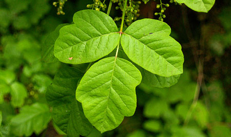
Finally, a less welcome “hero” in the post-fire forest recovery (to us humans, at least) is Poison oak. This amazingly adaptable, rather handsome shrub (and vine — it can grow in both forms) is found throughout the Columbia River Gorge as well as the lower Clackamas River canyon. In this view (below), Poison oak is emerging in the Clackamas burn zone alongside Thimbleberry, shiny with the oil that causes so much havoc in humans.

Like the other pioneers of the recovery, Poison oak grows from surviving roots and seems to benefit from fire with renewed growth and vigor. Poison oak also likes filtered sun in forest margins, so a tree canopy thinned by fire can create a perfect habit for this species. Like Thimbleberry and Elderberry, Poison oak is (surprisingly) an important browse for deer in recovering forests.

Forest recovery (gulp!) “hero”..? Poison oak!

Many other woody plants and hardy perennials also play an important role in the recovery of the forest understory, including Ocean spray, Oregon grape, Fireweed, ferns, and native grasses. These fast-growing, broad leafed plants are critical in quickly stabilized burned slopes, rebuilding a protective duff layer and providing shade and cover for wildlife to return.

So, if forests are so good at recovering from fire, can they recover from logging in much the same way? Read on.

Learning to be Part of the Fire Cycle?

If logged-over forests were left to their own recovery process, they would follow much sequence as a burned forest, with the understory rebounding quickly. However, fire usually leaves both surviving overstory trees and standing dead wood that are critical in the recovery by helping regenerate the forest with seedlings from the surviving trees, habitat in the form of standing snags and by providing nutrients from fallen, decaying dead wood. But even with the overstory cut and hauled away as saw logs, a clearcut could still recover quickly if the understory… if it were simply allowed to regenerate this way.

“It became necessary to destroy the forest in order to save it..?”

And therein lies the rub. Time is money to the logging industry, and they still view the broadleaf species that lead our forest recovery as “trash trees”, something to be piled up and burned in slash piles. So, the standard practice today is to shortcut the natural recovery process our forests have evolved to do, and simply kill the understory before it can even grow.

This is done by repeated helicopter spraying of clearcuts with massive amounts of herbicide after a forest has been cut, typically a year or two after the logging operation. This produces the brown dead zone that we are sadly familiar with in Oregon. Having killed the entire understory, cloned plantation conifers are then planted among the stumps with the goal of growing another round of marketable conifers in as short a period as possible. Time is money and trees are a “farm” not a forest to the logging industry.

These Douglas fir cultivars were bred for rapid growth and planted to shortcut a necessary stage in the recovery process, which is great for the corporate timber shareholders but very bad for forest health.

It doesn’t take a scientist to figure out that shortcutting the natural recovery process after logging also shortchanges the health of the forest over the long term, robbing the soil of nutrients that would normally be replaced in the recovery process and exposing the logged area to erosion and the introduction of invasive species (a rampant problem in clearcuts). Destroying the understory also robs a recovering clearcut of its ability to provide browse and cover for wildlife — ironically, one of the selling points the logging industry likes to use in its mass marketing defense of current logging practices.

In Oregon, this approach to fast-tracking forests is completely legal, though it is clearly very bad for our forests, streams and wildlife. As Oregon’s economy continues to diversify and become less reliant on the number of raw logs we can cut and export to other countries to actually mill (also a common practice in Oregon), cracks are beginning to form in the public tolerance for this practice. Most notably, private logging corporations are increasingly being held accountable for their herbicides entering streams and drifting into residential areas.

The understory in the uncut forest bordering this corporate logging operation shows what should be growing among the stumps, here. Instead, tiny first seedlings were planted after herbicides were used to kill everything else on this slope directly above the West Fork Hood River. This is standard forest practice in Oregon, sadly.

So, there’s some hope that the logging industry can someday evolve to embracing a natural recovery strategy, if only because they may not be able to afford the legal liability of pouring herbicides on our forests over the long term. Who knows, maybe the industry will eventually move to selective harvests and away from the practices of clearcutting if herbicides are either banned or simply too expensive to continue using?

The recent fires in the Columbia River Gorge, Mount Hood Wilderness and Clackamas River canyon may already be helping change industry our logging industry practices, too. These fires have all unfolded on greater Portland’s doorstep and have engulfed some of the most visited public lands in the Pacific Northwest.

While the initial public reaction was shock at seeing these forests burn, we are now seeing a broad public education and realization of the benefits of fire in our forests, with both surprise and awe in how quickly the forests are recovering.

Skeletons from the 1991 Multnomah Falls fire rise above recovering forests in this scene taken before the 2017 Eagle Creek Fire, when part of this forest burned again to continue the fire and recovery cycle in the Gorge.

That’s good news, because a public that understands how forests really work is a good check against the corporate interests who fund the steady stream of print and broadcast media propaganda telling us how great industrial logging really is for everyone.

Are we at a tipping point where science and the public interest will finally govern how the logging industry operates in Oregon? Maybe. But there’s certainly no downside to the heightened public awareness and appreciation of the role of fires in our forests. We do seem to have turned that corner…
How will the summer of 2015 affect our fall colors?

Shepperd's Dell dressed in autumn golds

Shepperd’s Dell dressed in autumn golds

Oregon may not have the neon rainbow of New England’s fall colors, but we put on a pretty good show if you know where and when to look. However, 2015 will be different, as the extended drought and scorching summer heat has already affected our fall colors this year, even before the leaves began to turn.

To understand why, you have to start with the basics of how leaf colors change with the seasons, and how weather and other factors influence the autumn show each year.

Leaf Biology 101!

Most of our northwest deciduous trees and shrubs leaf out in spring, grow green leaves through the summer, then turn to various shades of yellow and gold in fall, with a few red leaves in the mix. Vine maple, huckleberry and mountain ash provide our most brilliant reds, and most of the larger deciduous trees in our forests turn to some shade of gold, orange or yellow.

Vine maple colors range from pale yellow (in shade) to bright crimson (in full sun)

Vine maple colors range from pale yellow (in shade) to bright crimson (in full sun)

The green color in summer and spring foliage comes from chlorophyll, the amazing molecule that absorbs sunlight and allows for photosynthesis — the process by which plants convert sunlight into carbohydrates (sugars) essential to their growth.

During the spring and summer growing seasons, chlorophyll is produced continually, keeping deciduous leaves green. But as the days shorten with the approach of winter, the decrease in sunlight triggers a change in how cells in the stem of each leaf divide, gradually blocking the flow of both nutrients and chlorophyll to leaves. The cells that form this barrier within the leaf stem are known as the “abscission layer”.

Like vine maple, mountain ash fall colors range from light yellow to brilliant red, based on sun exposure

Like vine maple, mountain ash fall colors range from light yellow to brilliant red, based on sun exposure

Ready for more leaf biology? Well, the yellows, reds and golds of autumn are colors that already reside in leaves, but are revealed as the change to the flow of chlorophyll is blocked by the development of the abscission layer in early fall.

Yellows and golds in fall leaves come from “xanthophylls”, a pigment thought to regulate light in the photosynthesis process. Reds and purples come from “anthocyanins”, a molecule that is believed to complement the green of cholorophyll in the photosynthesis process — but is more commonly is found in flowers, where it functions to attract pollinators.

Dark, cool and wet…

Okay, enough leaf biology! If deciduous leaves are certain to turn color in autumn by their very chemistry, how do environmental factors fit into the leaf cycle? Here are the key forces that shape the timing and brilliance (or lack thereof) in our autumn color show:

Bright sun and cool temperatures: a crisp, abrupt fall pattern speeds up and pronounces the abscission process by which chlorophyll is blocked from leaves. This helps to promote sudden and dramatic color shows. Likewise, a mild, extended Indian Summer tends to slow the process, with a more gradual color change and leaves changing and falling over a longer period.

Cool mountain nights and bright, sunny days set these vine maple ablaze on Mount Hood's Vista Ridge

Cool mountain nights and bright, sunny days set these vine maple ablaze on Mount Hood’s Vista Ridge

Bright days and cool nights also enhance reds and purples in plants with abundant anthocyanins in their leaves. These include vine maple, huckleberry and mountain ash, our most vibrant fall foliage. That’s also why these colors are more prominent at higher elevations where bright days cool nights are guaranteed, even as the valleys are under a blanket of fog.

Early frosts: contrary to popular belief, early frosts hurt fall colors more than they help, as the production of anthocyanin-based colors of red and purple are abruptly interrupted by a premature formation of the abscission layer. If you’ve hiked in the mountains in late August after an early cold snap, you’ve undoubtedly seen a carpet of dropped leaves under huckleberries and other deciduous shrubs.

Drought: like early frosts, drought can trigger a premature formation of the abscission layer, leading to early color change and leaf drop. If you’ve been hiking in the Gorge or on Mount Hood this summer, you likely saw this effect of the drought we are experiencing. While some leaves survive later into autumn, the broader effect is a muted show, as many leaves have already dropped long before the typical fall color season. This is has already been the effect of the drought this year in both the Gorge and on Mount Hood.

Early autumn storms: the arrival of a Pineapple Express storm pattern during Labor Day week of 2013 did a fine job of stripping our maples and other deciduous trees of many of their leaves weeks before they would normally turn and begin to lose their foliage. It’s not common for early storms of this magnitude in our region, so it might be the most notorious culprit in stealing our fall colors!

The colors in this view of Umbrella Falls on Mount Hood are mostly huckleberry -- red when in full sun and yellow in shady stream areas

The colors in this view of Umbrella Falls on Mount Hood are mostly huckleberry — red when in full sun and yellow in shady stream areas

In an ideal year, normal rainfall in spring and summer are followed by a cool, dry Indian summer with warm days and cool nights in the 40s or 50s. This year, we’ve got the Indian summer condtions, but the drought has already triggered leaf drop in a lot of our deciduous forests. Thus, we’re likely to have a so-so color display this Fall.

Where and When to Catch the Colors

A muted fall color display this year shouldn’t keep you from heading out to enjoy it! In a typical year, the high country colors peak in September through early October. Mid-elevation areas and canyons usually peak from mid-October through mid-November, depending on the mix of tree species.

Here are some of the best spots in the Mount Hood area to catch the autumn color:

Elk Cove from Vista Ridge – this 9-mile out-and-back hike is one of the best for exploring Mount Hood’s high country without having to ford glacial streams or suffer huge elevation gains (though you will gain substantial elevation). In September of a typical year, fall colors light up the trail, especially as you descend into Elk Cove, but note that the colors are long gone from this hike in our drought year — see the Oregon Hikers Field Guide description

Elk Cove in late September (in a typical year)

Elk Cove in late September (in a typical year)

Clackamas River Trail – another close option for Portlanders, with a moderately long hike to Pup Creek Falls, albeit with moderate elevation gain. This trail is lined with bigleaf maple, but also has impressive vine maple shows in a recovering burn section that bring shades or red and coral to the trail in October. You’ll also see Douglas maple here, a close but less common cousin to vine maple — see the Oregon Hikers Field Guide description

Brilliant vine maple along the Clackamas River Trail

Brilliant vine maple along the Clackamas River Trail

Lookout Mountain Loop – Always a spectacular hike on a clear day, in October you will also see the annual spectacle of western larch turning golden yellow across the eastern slopes of the Cascades. Larch are a deciduous conifer — a rarity, and an impressive sight — see the Oregon Hikers Field Guide description

Whole mountainsides around Lookout Mountain light up with western larch turning in mid-to-late October

Whole mountainsides around Lookout Mountain light up with western larch turning in mid-to-late October

Latourell Falls Loop – Very close to Portland, this is a popular family hike that visits two waterfalls in a lovely rainforest canyon. In late October, bigleaf maple that dominate the forests here light up in shades of yellow and orange, often covering the trail ankle-deep in their huge leaves — see the Oregon Hikers Field Guide description

The Latourell Falls loop trail still has some color in early November

The Latourell Falls loop trail still has some color in early November

Starvation Creek Loop – like the Latourell loop, Starvation Creek has an abundance of bigleaf maple, but the crisper weather and abundant sun of the eastern Gorge often makes for a brighter show here. Families can simply explore the paved trails around the main falls, but the Lower Starvation hike makes for a fun, if sometimes steep loop past more waterfalls and clifftop viewpoints — see the Oregon Hikers Field Guide description

Bigleaf and vine maple put on a reliable show at Starvation Creek Falls in October

Bigleaf and vine maple put on a reliable show at Starvation Creek Falls in October

Butte Creek Trail – an under-appreciated family trail that does require navigating some harshly managed corporate timber holdings. The outrageous, utterly unsustainable clear-cutting only makes the pristine public forests and waterfalls along the trail that much more spectacular in comparison. This is an ideal October hike, with fall colors typically peaking in the last half of the month. This trail really shines in rainy or overcast weather, when the rainforest glows with countless autumn shades of yellow, gold and orange against a backdrop of deep green – see the Oregon Hikers Field Guide description

The author ankle-deep in maple leaves on the Butte Creek Trail

The author ankle-deep in maple leaves on the Butte Creek Trail

The great thing about taking in fall colors is that the weather really doesn’t matter — a soggy hike through the brilliant yellows of bigleaf and vine maple in a waterfall canyon is just as spectacular as a sunny day hiking through a sea of red and orange in Mount Hood’s huckleberry fields.

Better yet, if you have kids, it’s also a great time to expose them to hiking and exploring the outdoors… though you should also plan on hauling home a hand-picked collection of autumn leaves..!

Enjoy!

Clackamas River Trail

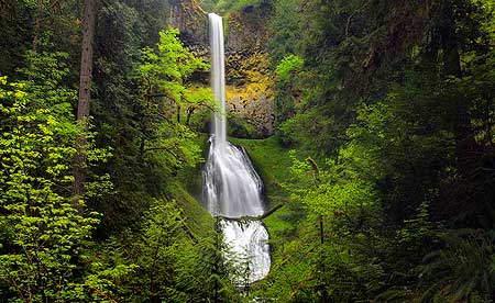
Pup Creek Falls on the Clackamas River Trail

Though no longer a well-kept secret, the relatively new Clackamas River Trail from Fish Creek to Indian Henry Campground provides a scenic, all-season alternative to the often crowded low-elevation trails in the Columbia Gorge. An added bonus is the impressive falls on Pup Creek — the main attraction for many who make this trip. But the trail also provides a unique, close-up look at a rapidly recovering forest ecosystem that burned less than a decade ago, and plenty of river scenery along the way.

The Fire Zone

In September 2002, the Bowl Fire swept through 339 acres of tall timber along the first mile or so of the Clackamas River Trail, just east of Fish Creek. Today, nine seasons of forest recovery have brought a rejuvenated understory with sun-loving wildflowers crowding the trail. While many trees were killed, a surprising number of the old giants survived, providing a living laboratory on the role of fire in our forest ecosystems.

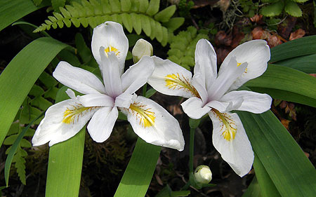
White Clackamas iris (Iris tenuis S. Watson)

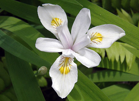
Along this section of trail, the fire has been especially beneficial to the rare Iris tenuis S. Watson, or Clackamas iris. This elegant wildflower occurs in both blue and white in its very narrow range. It is found along the Clackamas and Molalla Rivers, and nowhere else. These iris form beautiful drifts of white blossoms along the burned section of trail in late May and early June.

White Clackamas iris (Iris tenuis S. Watson)

Ancient Forests

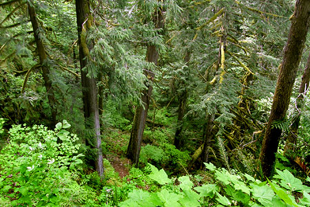
Beyond the fire zone, the trail dips into an impressive stand of ancient forest, tucked into a shady grotto between 200-foot cliffs and the Clackamas River, at the confluence with the Roaring River. These centuries-old western red cedar and Douglas fir thrive in the boggy river bottom, well protected from the elements.

In spring, the air in this pocket of ancient forest is filled with the pungent (and unmistakable) aroma of skunk cabbage growing in the bog, while the sound of falling water reveals a string of delicate waterfalls cascading over the cliffs, and into the green grotto.

Looking down at ancient forest from a cliff-top viewpoint

After passing through this magical spot, the Clackamas River Trail climbs a steep, rocky bluff above this hidden forest, providing a unique opportunity to observe the big trees from different levels, as if riding an elevator.

Hiking The Trail

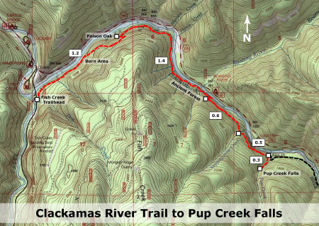
Guidebook descriptions vary, but by my estimate, the hike from Fish Creek to beautiful Pup Creek Falls is about 8 miles round-trip, with the rollercoaster trail gaining about 900 feet in elevation along the way as it climbs around several cliffs. Because the high point at Pup Creek is only 1,300 feet in elevation, the trail is usually open year-round.

[Click here for a larger map]

The trail starts at the Fish Creek trailhead, located about 15 miles southeast of Estacada on Highway 224. The turnoff to Fish Creek is well marked, and is just past the Carter Bridge, Lockaby and Armstrong campgrounds.

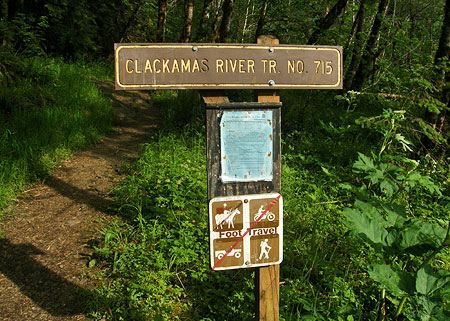
Turn right onto Fish Creek road, pass the Fish Creek campground, cross the Clackamas on yet another bridge, then watch for the trailhead parking on the right, at the confluence of Fish Creek and the Clackamas. The trail begins at the far (south) end of the parking area, on the opposite side of the road, and is marked with a signpost.

The Fish Creek Trailhead

The path starts out wide and gentle, following a rustic dirt road to a small stream ford and dropping to the banks of the Clackamas. From here, the trail briefly rambles at river grade before entering the fire zone. Soon, the first uphill section begins as the trail climbs through the burn and over the first set of cliffs. On the bluff above the cliffs, white Clackamas iris line the trail in spring, along with many other wildflowers.

After the first crest, the trail descends to the river again, reaching a short pair of switchbacks just over a mile from the trailhead. Caution: watch for poison oak on both sides of the trail after the second switchback for a hundred yards or so — this is the only notable poison oak patch along the trail, but worth watching for (see map, above).

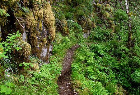
Section of the Clackamas River Trail

The trail follows the river bank only briefly, as the roller coaster trip through the burn section continues for another half-mile or so. Soon, the trail leaves the burn, and crosses the first in a series of small streams as it descends toward the ancient forest section, at about the 2-mile mark. There is a large riverside campsite among the giant cedars, here, and this makes a good spot to turn around if you are looking for a shorter hike.

Continuing through the ancient forest, the trail passes the skunk cabbage bog before crossing the largest of several streams dropping into the ancient forest grotto — and take a look upstream, too: a nearly hidden waterfall leaps off the cliffs beyond the big trees.

Next, the trail climbs a rocky bluff in a couple of switchbacks, providing that “elevator” view of the ancient forest, then a glimpse of the Roaring River confluence with the Clackamas, across the canyon. From here, the trail levels off, following the top of a bank of mossy cliffs for the next half-mile or so.

Steppingstone Creek

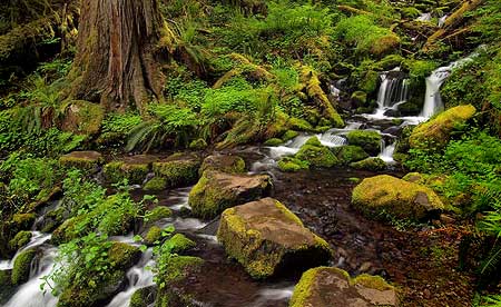
Soon, the trail crosses yet another lively creek, this one called “Steppingstone Creek” on the map for the helpful (and picturesque) series of stones that carry hikers across. From here, the final half-mile to the junction with the Pup Creek climbs very gently, with many river views.

The junction with the short spur to Pup Creek Falls is marked with a post, though no sign attached as of this spring. But you’ll know when you’re there: the junction is in a clearing under a transmission pylon. If you miss it, you’ll arrive at Pup Creek after 200 feet or so — by far the largest side stream on the hike, so you’ll know if you need to backtrack.

Upper Tier of Pup Creek Falls

The spur trail to the falls makes one quick switchback, but otherwise follows Pup Creek upstream to the dramatic amphitheater holding the 237-foot falls. In winter and early spring, the falls are particularly impressive, jetting a lot of spray to the small viewpoint at the end of the spur trail, so early season photographers should be prepared to battle the mist!

Because the falls are framed by a group of magnificent bigleaf maples, this is an ideal destination for late October or early November, when fall colors are peaking, and yellow maple leaves complement the bright yellow lichens on the walls of the amphitheater.

Traveler Tips

Highway Noise: on summer weekends, traffic on Highway 224 is more noticeable, so it’s a good idea to save this hike for mid-week, or the off-season for summer camping — or even winter, when you’ll have the place to yourself. That said, the highway proximity is rarely a distraction from the beautiful scenery on this trip.

“Leaves of three, let it be!”

Poison Oak: note the map, above — one enthusiastic patch of poison oak flanks both sides of the trail at the 1.2 mile mark, where the route descends through a short pair of switchbacks. The itchy stuff begins at the second switchback and continues for a couple hundred yards, but is easy to avoid if you know to watch for it.

Ticks: though rare, ticks have also been reported in the lower Clackamas canyon, so be sure to do a tick check after your trip — a good idea after any hike.

Camping: one of the handy aspects of this trail is the amazing selection of campgrounds in the vicinity — more than a dozen line the lower Clackamas. Two offer walking access to the trail: Fish Creek, near the trailhead described in this article, and Indian Henry, located about four miles beyond Pup Creek.

Forest Pass: the Fish Creek trailhead requires a Northwest Forest Pass, though this trailhead also has the option of a $5/day onsite payment for a day pass.