First Look at the Gorge Fire

GorgeFire01

Eagle Creek Fire during the initial, explosive phase (US Forest Service)

Officially the Eagle Creek Fire in the Columbia River Gorge is still fully involved, now at 35,000 acres and just 10 percent contained by firefighters. Rain in the forecast for the coming week suggests that the fire will continue to slow as October approaches, and our attention will turn toward the changes that fire has once again brought to the Gorge.

The Gorge is a second home for many of us, and in some ways the fire was akin to watching our “home” burn. But that’s a human perspective that we should resist over the long term if we care about the ecological health of the Gorge. Fire is as natural and necessary as the rain in this amazing place, though that’s a truth that we have been conditioned to resist. I’ll post more on that subject in a subsequent article.

GorgeFire02

Surreal Gorge landscape under smoky skies from the Eagle Creek Fire (US Forest Service)

For now, we’re just beginning to learn about the impact of the fire, even as it continues to burn. Thankfully, no lives have been lost, no serious injuries reported and very few structures have been lost. That’s a testament to our brave emergency responders (many of them volunteers) and the willingness of most Gorge residents to abide by evacuation orders. It has surely been a frightening and stressful time for those who call the Gorge home.

The impact on public lands is still largely unknown, but the Oregon side of the Columbia River Gorge has one of the most concentrated, most heavily used trail systems in the world, and the damage to trails is likely to be significant. The Forest Service is likely to close affected trails for months or even years in order to assess the damage and determine how best to restore them.

GorgeFire03

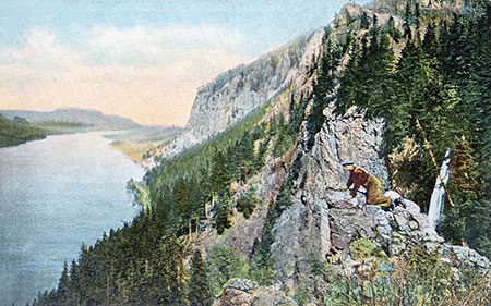
1930s hiker at a viewpoint along the Perdition Trail (with Multnomah Falls beyond)

If you’ve lived here for awhile, you’ll also recall that we lost the Perdition Trail, an iconic, prized connection between Wahkeena Falls and Multnomah Falls, to the 1991 Multnomah Falls Fire. The reasons were complex, and it will tempting for the Forest Service to let some trails go, given their shrinking trail crews. We should not allow this to happen again.

Every trail should be restored or re-routed, and new trails are also needed to spread out the intense recreation in the Gorge. Trails advocates will need to work together to ensure this. Trailkeepers of Oregon (TKO) has set up a mailing list dedicated to Gorge trail restoration, if you’re interested in working on future volunteer projects. You can sign up for periodic updates and events here.

______________________

On September 10, I drove SR 14 on the Washington side of the Gorge for my first look at the fire, starting in Hood River. Below each of the following annotated photos, I’ve linked to much larger versions that I encourage you to view if you’re reading this on a large monitor, as they provide a better sense of the fire’s impact.

As hoped, much of the burn is in a patchy “mosaic” pattern, a healthy and desirable outcome for the ecosystem. This is how fires used to occur in our forests, before a century of suppression began in the early 1900s. Mosaic burns allow for mixed forest stands and exceptional wildlife habitat to evolve, even as we might mourn the loss of familiar green forests.

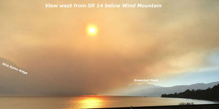
The wind pattern on Sunday had shifted from westerly to a northwesterly direction, producing a bizarre effect: smoke from the fire hugged the vertical wall that is the Oregon side of the Gorge, while the Washington side was cleared of smoke and under a bright blue sky. The view, below, shows this split-screen effect from near Wind Mountain.

GorgeFire04

(Click here for a large view)

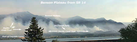
Moving west, the combination of ongoing wildfire and back-burning by firefighters was producing a continuous plume along the base of the Oregon cliffs, from Herman Creek east to Shellrock Mountain, as seen below. The Pacific Crest Trail traverses this section, and is undoubtedly affected by the fire.

GorgeFire05

(Click here for a large view)

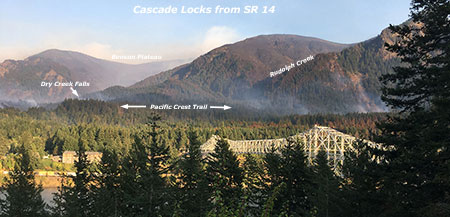
From the Bridge of the Gods wayside, opposite Cascade Locks, the impact of the fire on the canyons that fan out from Benson Plateau is visible. Some areas (below) show a healthy mosaic burn, while some of the upper slopes show wider swaths of forest impacted. The alarming proximity of the fire to the town of Cascade Locks is also evident in the scorched trees visible just above the bridge in this view. This was a close call for those who live here.

GorgeFire06

(Click here for a large view)

Turning further to the east from the Bridge of the Gods wayside (below), the ongoing wildfire and back-burning shown in the previous photos can be seen in the distance, beyond the town of Cascade Locks.

GorgeFire07

(Click here for a large view)

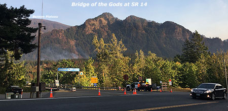
The scene at the Bridge of the Gods bridgehead (below) is an ongoing reminder that we’re a long way from life returning to normal for Cascade Locks residents. For now, I-84 remains closed and this is the only route into town, and only open to those with proof of residency.

GorgeFire08

(Click here for a large view)

Moving further west, the 2000-foot wall of cliffs in the St. Peters Dome area that stretches from McCord Creek to Horsetail Creek (below) come into view.

Here, the fire has also burned in mosaic pattern, with many patches of green forest surviving. But the frightening effects of the firestorm that occurred in the first days of the fire is also evident, with isolated trees on cliffs hundreds of feet above the valley floor ignited by the rolling waves of burning debris that were carried airborne in the strong winds that initially swept the fire through the Gorge.

GorgeFire09

(Click here for a large view)

A second view (below) of the St. Peters Dome area shows the burn extending toward Nesmith Point, nearly 4,000 vertical feet above the Gorge floor.

GorgeFire10

(Click here for a large view)

Moving west along SR 14 to the viewpoint at Cape Horn, the impact of the fire on areas west of Horsetail Falls comes into view (below), along with a better sense of the mosaic pattern of the burn. This view shows the Horsetail Creek trail to be affected by the first, as well as the slopes on both sides of Oneonta Gorge.

In this earlier piece on Oneonta Gorge, I described the dangerous combination of completely unmanaged visitor access and an increasingly dangerous logjam at the mouth of the Gorge. The fire will almost certainly trigger a steady stream of new logs rolling into Oneonta Gorge and adding to the massive logjam in coming years.

GorgeFire11

(Click here for a large view)

Moving further west, the area surrounding iconic Multnomah Falls and Wahkeena Falls comes into view (below). As with other areas, the fire burned in vertical swaths along the Gorge face, leaving more mosaic patterns in the burned forest. From this view, trees along the popular 1-mile trail from Multnomah Falls Lodge to the top of the falls looks to be affected by the fire, as are forests above Wahkeena Falls.

GorgeFire12

(Click here for a large view)

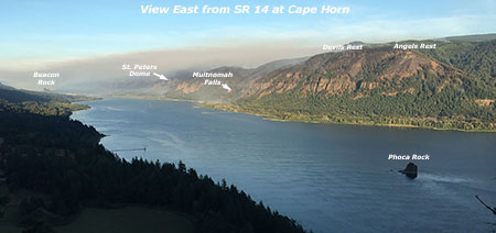
This wide view looking east from above Cape Horn (below) shows most of the western extent of the fire, with the north-facing slopes of Angels Rest heavily burned, while the west and south-facing slopes were less affected.

GorgeFire13

(Click here for a large view)

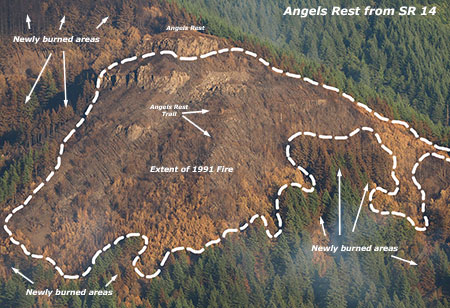
A closer look at Angels Rest shows that the burned area in the current fire closely matches the area that burned in the 1991 (below), along with slopes on the opposite side of Coopey Falls. The Angels Rest Trail was heavily impacted by the 1991 fire, and will clearly need to be restored after this fire, as well.

GorgeFire14

(Click here for a large view)

I’ve marked an approximation of the 1991 fire extent at Angels Rest in this closer look (below) at the summit of Angels Rest, based on tree size. Tall conifers burned in today’s Eagle Creek fire survived the 1991 fire, and mark the general margins of that earlier fire.

Areas within the 1991 burn were still recovering and consisted largely of broadleaf trees, like Bigleaf and Vine maple. Depending on the heat of the fire and whether their roots survived, these broadleaf trees may be quick to recover, sprouting from the base of their killed tops as early as next spring.

The recurring fires at Angels Rest offer an excellent case study for researchers working to understand how natural wildfires behave in successive waves over time. This, in turn, could help Gorge land managers and those living in the Gorge better plan for future fires.

GorgeFire15

(Click here for a large view)

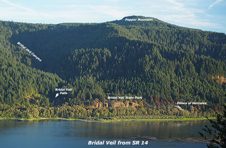
Finally, a look (below) at the western extent of the fire shows a few scorched areas in Bridal Veil State Park, including the forest around the Pillars of Hercules. Bridal Veil Canyon appears to have escaped the burn, though some trees near Bridal Veil Falls may have burned.

GorgeFire16

(Click here for a large view)

I’ve titled this article as my “first look” because the story of the Eagle Creek fire is still being written. Only after the fall rains arrive in earnest will we have a full sense of the scale of the fire.

As new chapters in the Eagle Creek saga unfold, I’ll continue to post updates and share perspectives on this fire and our broader relationship with fire as part of the natural systems that govern our public lands. With each new fire in close proximity to Portland, we have the opportunity to expand and evolve how we think about fire, and hopefully how we manage our public lands in the future.

More to come…

CLIMB (the un-casino)

Mountain biking is a natural fit for the Gorge (Photo: Wikimedia Commons)

With the controversy (apparently) behind us on the now-defunct Cascade Locks casino proposal, conservationists have focused their Gorge concerns on a Nestle Corporation proposal: truck bottled water from a natural spring at a little-known fish hatchery on the edge of Cascade Locks (described in this WyEast Blog article)

The Nestle proposal is a bad idea on so many levels, and ought to be stopped. But the fracas over Nestles has overshadowed a very good idea known as the Cascade Locks International Mountain Bike Trail, or CLIMB. The concept is to simply build on the network of existing trails, old forest roads and a few new trails to create a world-class mountain biking destination, accessible from downtown of Cascade Locks.

Mountain bikers on a wintry Oakridge Trail (photo: Travel Oregon)

This proposal is exactly the kind of quiet recreation-oriented tourism strategy that put Hood River back on the map after the timber collapse in the early 1980s, and has the potential to revitalize Cascade Locks as well. The former mill town of Oakridge has kicked off a similar effort to foster bike tourism, advertising itself as the “Mountain Biking Capital of Northwest”, and bringing an impressive network of trails online over just a few years. These communities provide working examples for Cascade Locks in making a successful transition to a tourism-based economy.

Conservationists should be enthusiastically supporting the CLIMB idea, and any others like it that build on the natural and scenic character of the Gorge, as a counterpoint to the justified opposition to clunker schemes like the casino and Nestle plant that would harm the Gorge.

CLIMB West

The Cascade Locks proposal begins with a new trail traversing above the community from a western trailhead near the Bridge of the Gods to an eastern terminus at the Oxbow Fish Hatchery (where Nestle proposes to bottle the natural springs by the semi-truck load).

[click here for larger map]

Along the way, the proposed trail would cross Dry Creek, intersecting the primitive access road that follows the creek upstream to beautiful Dry Creek Falls.

Curiously, the proposal does not incorporate this old road into the mountain bike network — a missed opportunity to close the route to ATVs and motorcycles that routinely use the road to loop onto the Pacific Crest Trail. Cyclists would likely find their way to the falls, of course, but including this road segment in the system would be a great way to transition the route (and surrounding area) to quiet recreation.

Dry Creek Falls

Another missing link in the western portion of the network is from the Oxbow Fish Hatchery to Herman Creek. While the terrain here is challenging, making this connection on trails — as opposed to following the freeway frontage road, as shown in the draft plan — could be critical to the viability of the network as a system based in Cascade Locks. The goal for the project should be for cyclists to start and end their tour in Cascade Locks, not at trailheads located east of town along forest roads (though that would certainly occur, as well).

Hopefully, the plan can at least include a long-term concept for making a new trail connection across Herman Creek to fully integrate the trail system with the town of Cascade Locks.

CLIMB East

Most of the proposed CLIMB network is located along the corridor between Herman Creek and Wyeth, with a combination of new trails and existing routes that would create a number of loops and interesting destinations, with trail access at several points along the way.

[click here for larger map]

This part of the proposal envisions using Trail 400 and a short segment of the Herman Creek Trail as part of the network, a move that hikers might be leery of, but one that is highly workable and necessary to create trail loops. Trail 400 is gently graded and meticulously maintained, so is a good candidate for shared use. The segment of the Herman Creek Trail included in the proposal is really just an old road, so can easily accommodate the additional traffic and mix of bikes and hikers.

The eastern trail proposal would be anchored by the Herman Creek and Wyeth Campgrounds. While a plus for cyclists looking for a camping/cycling experience, this underscores the need for a direct trail connection from Herman Creek to Cascade Locks, and the potential economic benefit it would bring, including bike campers riding to town for a meal, beer or supplies.

Rustic bridge along Trail 400 at Gorton Creek

The Historic Columbia River Highway (HCRH) restoration project is considering adding the Herman Creek to Wyeth roadway to the historic highway corridor, a move that would provide a terrific complement to the mountain bike trail concept. Already, this road provides excellent opportunities for small trailheads accessing the proposed system, allowing for more route possibilities for cyclists and shuttles.

One missed opportunity in the eastern part of the proposal that could be both bold and iconic would be repurposing the Forest Service work center at Herman Creek to function as a trailhead base for cyclists. This historic structure dates back to the Civilian Conservation Corps era, but has been relegated to administrative uses by the Forest Service. The CLIMB proposal could turn this structure into a flagship facility for cyclists, possibility with a public-private lodge function patterned after the lodges at Timberline and Multnomah Falls.

Historic work center at Herman Creek

The old work center also features a nearly lost trail connection that switchbacks directly to the Herman Creek Campground (and shown on the CLIMB trail concept), providing a nice complement for cyclists camping in the area if the work center were to become some sort of base facility.

Thinking bit further outside the box, another opportunity could be to add the old quarry site at nearby Government Cove to the proposed trail network.

View from the beach at the Government Cove site

The quarry is on a peninsula that separates the Columbia River from the cove, and has the potential to be a terrific riding destination, especially for riders following street routes from Cascade Locks to the Herman Creek trailhead. It would also bring the CLIMB network to the river, which is currently a missing piece in the proposal. The property appears to be port-owned, so could be a natural fit, given the port’s role in advocating for the project.

Project Timeline

Since the project began in 2007, a feasibility study, conceptual trail plan and master trail plan have already been completed with funding support from the Port of Cascade Locks, City of Cascade Locks, and Hood River County.

The next step is to conduct an environmental review of the trail corridor. In late 2010, the Port of Cascade Locks reached an agreement with the U.S. Forest Service to perform the required National Environmental Policy Act (NEPA) analysis of the proposal using private consultants, since the Forest Service lacked the capacity to do this work in the near future. Several proposals to complete the work were received earlier this year, but at a cost of $170,000 to almost $400,000, were financially out of reach for the Port of Cascade Locks.

The Port and the USFS have since worked out a tentative agreement to allow this project to continue to move forward using limited Port funding to begin gathering environmental data, with the Forest Service taking over the environmental analysis in 2013, using this data.

Learn More & How to Help

For more information on the proposal, including more detailed maps, visit to the Port of Cascade Locks site here. You can also view photos of the proposed trail routes and promote the idea using the project’s Facebook link. Someday, we may have a world-class mountain bike network defining the economy in Cascade Locks, who knows?

But in the meantime, the best way to keep casinos and Nestle trucks from tainting the Gorge is to vote with your wallet, and simply to support local businesses in the Gorge that rely on tourism. If you traditionally stop somewhere in the Portland area for a beer or burger after a hike or trail ride, consider a stop in Cascade Locks, Stevenson or Hood River, instead.

Dry Creek Ponds: Orphaned Gems

Dry Creek flows into a series of lush ponds just south of I-84.

Dry Creek flows into a series of lush ponds just south of I-84.

Just inside the city limits of Cascade Locks — and just outside the protection of the Columbia Gorge National Scenic area — lie a series of beautiful ponds and an adjacent group natural springs so pure that a national bottled water corporation is considering a new plant here. The ponds, themselves, are posted with real estate signs advertising dream home sites in this pretty location, albeit within earshot of noisy I-84.

The ponds underscore one of the dilemmas facing natural sites in the Columbia Gorge that happen to fall within the designated “urban areas” that are excluded from scenic area protection. Most of the Gorge towns are too small to have the fiscal means to protect these orphaned gems, even if they wanted to. Meanwhile, the non-profit organizations and federal agencies involved in land acquisition focus exclusively outside these urban areas. The result is a surprising number of natural features that face great risk of development, with no clear path for protection.

Dry Creek is better known for its waterfall, about a mile upstream from the ponds.

Dry Creek is better known for its waterfall, about a mile upstream from the ponds.

In the case of the Dry Creek Ponds, much of the land is already up for sale, and the real question is whether some sort of public purchase could intervene, and save the ponds from development. The ponds are not entirely pristine: a frontage road along I-84 borders one of the ponds, and there are a few homes tucked into the forest near the ponds. But the ponds are largely undeveloped, and surely worth more to the public as protected natural areas than to a few as exclusive home sites.

One option for protecting the ponds is the federal acquisition program operated by the Forest Service to consolidate lands within the scenic area. Their guidelines focus outside the urban areas, but a case could easily be made to cross those boundaries when natural sites are adjacent to surrounding public land. This is the case for the Dry Creek ponds, which not only abut the scenic area, but also the federal Oxbow fish hatchery.

Dry Creek ponds are located outside the protection of both the National Scenic Area boundary and the nearby Oxbow fish hatchery.

Dry Creek ponds are located outside the protection of both the National Scenic Area boundary and the nearby Oxbow fish hatchery.

A second option for protection are the private agencies involved in land acquisition within the scenic area. These organizations typically turn most of their acquisitions over to the federal government for long-management, so in the case of the Dry Creek Ponds, it would still be important to find a way for federal acquisitions to exist inside the urban areas.

A third option is for local governments to step up to the challenge, and create a municipal park or natural area for its local citizenry. In this case, the City of Cascade Locks is the local government in question, and like most of the small cities in the Gorge, is financially strapped. So a hybrid approach where the federal agencies, or perhaps the non-profits (or both) help the small cities make strategic acquisitions of places like the Dry Creek Ponds.

The ponds are teeming with wildlife, despite the noise of the nearby freeway.

The ponds are teeming with wildlife, despite the noise of the nearby freeway.

One of the truisms about sudden growth in small communities like Cascade Locks is that the civic awareness of threats to natural areas usually comes too late in the development boom. After years of slow growth, Cascade Locks is slowly awakening. So, like other Gorge communities, the town is entering a short window of opportunity for natural area protection that will be fleeting.

The Dry Creek Ponds are worth saving. The ponds are home to waterfowl, beaver and a thriving population of other species in the wetlands and forest that border the ponds. The ponds are unique in having such close proximity to Cascade Locks, and therefore easy access for visitors. This is one of only a few places in the Gorge where it is easy to get very close to a pond ecosystem, and thus could provide a valuable place for learning and wildlife watching.

Wetland birds thrive in tall marshes that border the ponds.

Wetland birds thrive in tall marshes that border the ponds.

The ponds could also provide a starting point for hikers to head up Dry Creek to the falls — or points beyond along the Pacific Crest Trail, which passes just above the ponds, inside the scenic area.

In the end, the fate of the ponds will be a measure of our collective will to protect the larger Gorge landscape for generations to come, no matter where we’ve drawn lines on maps or how we have divided public land management responsibilities. In this way, the ponds provide an opportunity for local citizens, public land stewards and non-profit environmental advocates to show that our collective vision extends across those artificial boundaries.