Elk Cove Avalanche!

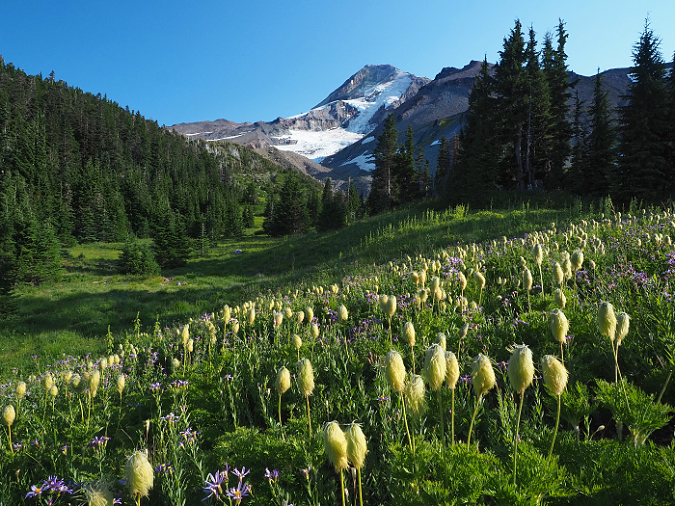
Mount Hood from Elk Cove in 2021

When it comes to bucolic alpine scenes on Mount Hood, it’s hard to beat Elk Cove. From the spectacular wildflower gardens that line ice-cold Cove Creek to the sweeping views of Mount Hood and the mighty Coe Glacier, the cove serves up one postcard scene after another. 

But behind the mountain scenery are some very wild winters. The same steep walls that give Elk Cove its alpine beauty are also a setup for powerful avalanches. These mostly originate on the lower slopes of Barrett Spur and sweep across the cove with surprising regularity. 

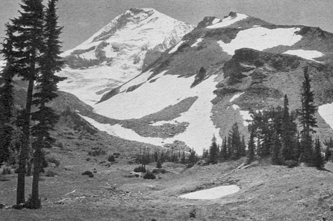
Mount Hood in 1931 from the same spot as the previous photo, when trees were more sparse at Elk Cove

Early photos of Elk Cove suggest that avalanches were once even more devastating than what we experience today, and probably more frequent, judging by the advancing stands of Mountain Hemlock that have since spread across the cove. The change is most likely a reflection of our warming climate and declining snowpack in recent decades, but winter continues to take its toll. Major avalanches still roar into the cove with regularity, leveling trees and leaving piles of debris in their wake.

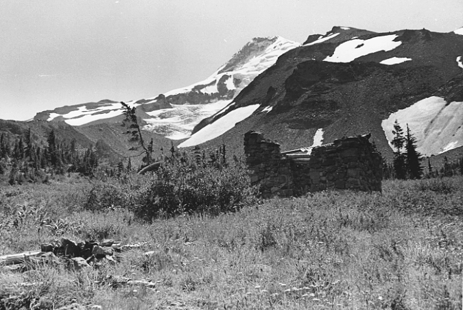
The shell of the old CCC stone shelter at Elk Cove as it appeared in the early 1960s, after being hit by numerous avalanches over the prior 30 years

When the Timberline Trail was built through Elk Cove in the early 1930s, Franklin Roosevelt’s legendary Civilian Conservation Corps (CCC) constructed one of their many iconic stone shelters here, one of six that were built along the trail. They couldn’t have known the site they picked was perhaps the most exposed to avalanches of any spot within the cove, and by the early 1960s, the shelter had already been badly damaged. Today, only a few rocks mark the shelter’s former location.

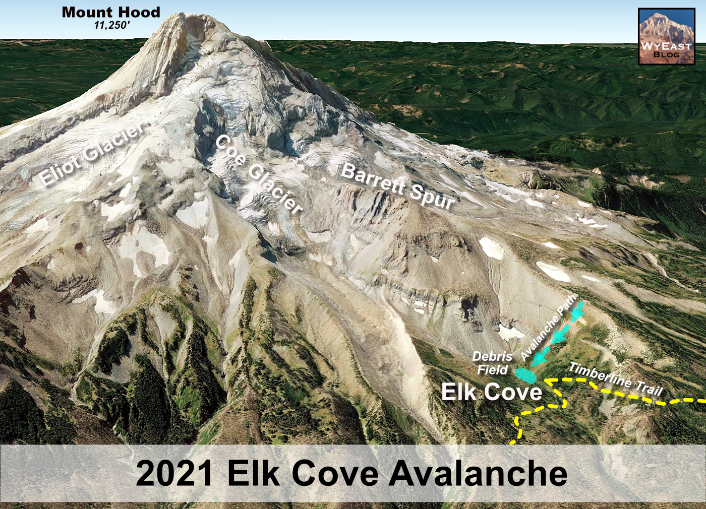
The 2021 Elk Cove Avalanche

Sometime last winter, yet another avalanche swept off the lower slopes of Barrett Spur, once again landing very near where the old stone CCC shelter had once stood. The debris field left behind by the avalanche was easily spotted by hikers ascending Barrett Spur over the summer, and it is also visible from the Timberline Trail where it enters the Elk Cove.

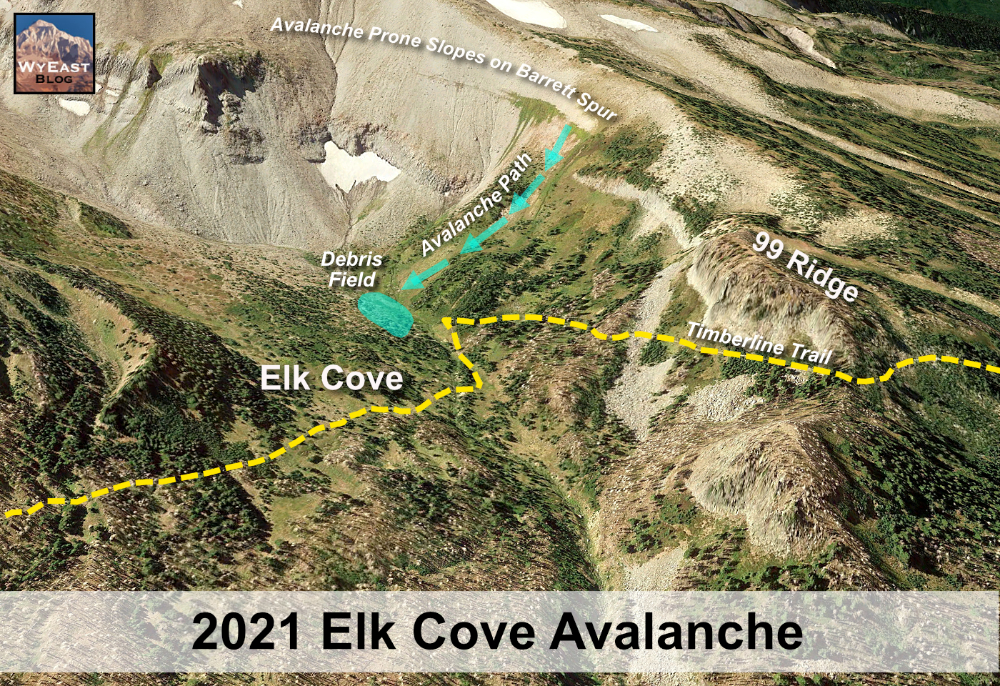
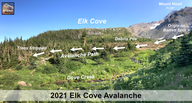
The following schematic shows Elk Cove and the path of the 2021 avalanche in relation to Mount Hood:

[click here for a larger version of this schematic]

This schematic gives a more detailed view of Elk Cove and the approximate path of the 2021 avalanche, including the steep wall along Barrett Spur that is so prone to avalanches (the Timberline Trail is shown in dashed yellow):

[click here for a larger version of this schematic]

From the ground, the debris field left where the avalanche came to rest is striking. This series of views looking down from 99 Ridge (which forms the west wall of Elk Cove) show where the avalanche stopped, and the debris it left behind:

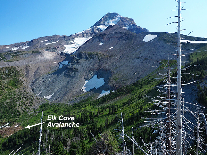
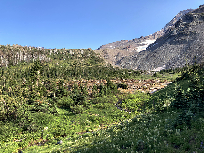
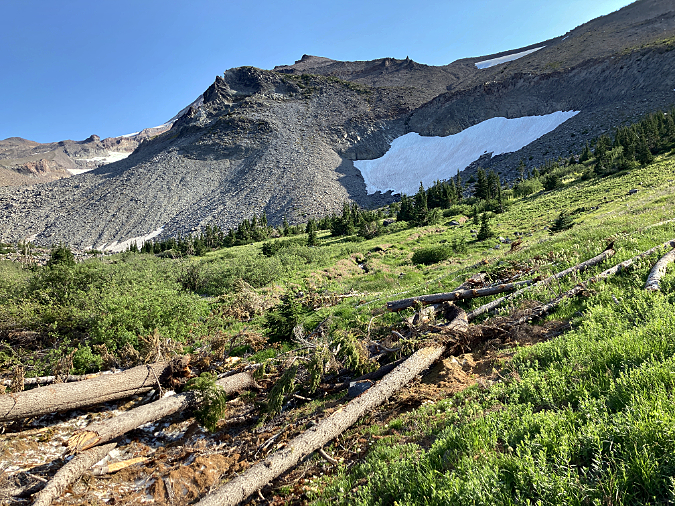
Mount Hood and the 2021 Elk Cove avalanche site

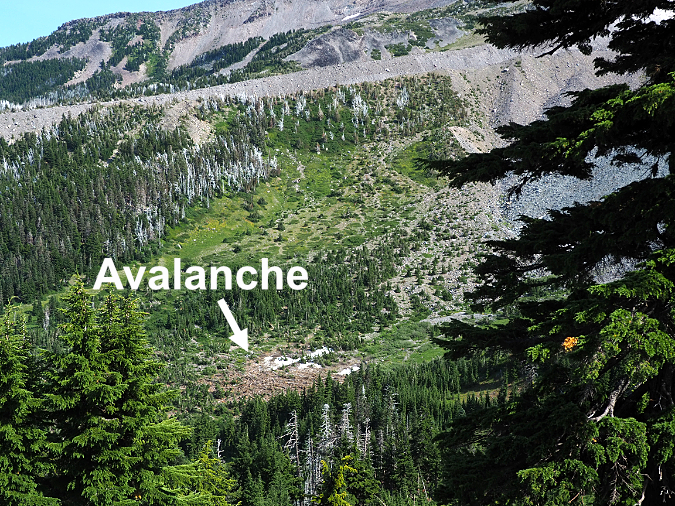
Closer view of Elk Cove and the avalanche debris field

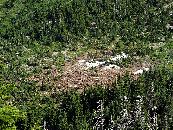
More detailed view of the avalanche debris field

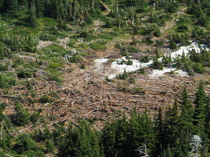
This detailed view from above gives a sense of scale to the hundreds of trees that were caught up in the avalanche and swept into Elk Cove

The debris comes into view where the Timberline Trail curves into the west meadow of Elk Cove, along beautiful Cove Creek. Most hikers were likely too busy looking at the wildflowers along the trail this summer to notice the pile of logs just around the bend, but for regular visitors, the avalanche debris was startling!

Elk Cove avalanche and Cove Creek from the Timberline Trail

The origin of the avalanche can be read from the orientation of the many trees caught up in the wave of snow and ice, as they generally point in the direction of the flow. The schematic below shows the path the avalanche took into Elk Cove before the snow and debris finally came to a stop last winter:

[click here for a larger version of this schematic]

Up close, the awesome power of the avalanche becomes apparent. Whole trees were snapped off and stacked like cordwood in a debris pile as much as 20-foot deep.

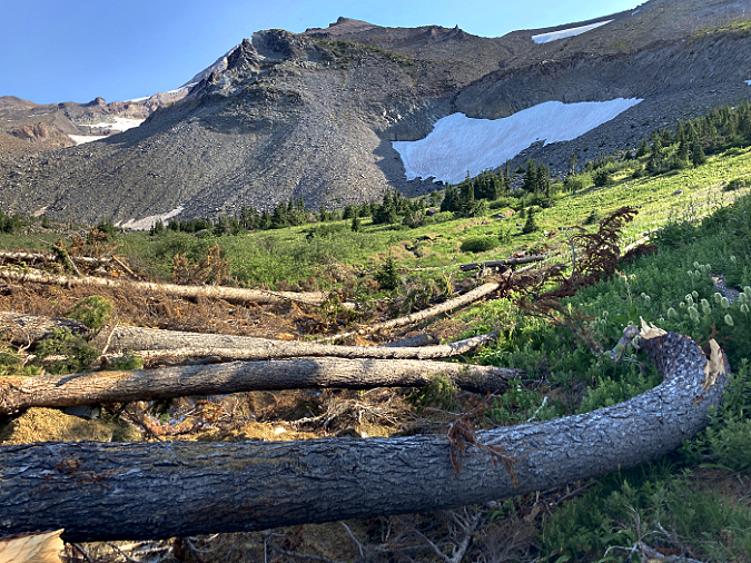
The avalanche swept down from the slopes of Barrett Spur (to the right in this view), as indicated by the felled trees pointing to the left, in the direction of the flow

In a typical winter, Elk Cove might have 15-20 feet of snow on the ground, and this snowpack is why small trees on steep mountain slopes are often spared from avalanches, since they are buried under heavy snow in winter. In the view below, the winter snowpack also protected the lush wildflower gardens that line the upper reaches of Cove Creek (seen in the distance), with the avalanche sweeping across these gentle slopes before finally settling on the floor of the cove.

The beautiful wildflower meadows in the upper reaches of Cove Creek were spared from the debris thanks to being on gently sloped terrain and under a blanket of winter snow when the avalanche swept through

Large trees aren’t so fortunate. If they’ve managed to escape avalanches along the base of Barrett Spur long enough to grow taller than the winter snowpack, it’s only luck. In time, most of the taller trees in Elk Cove will be swept away by future avalanches. 

This panoramic view of the 2021 avalanche gives a sense of the scale of the event, with the sprawling pile of debris covering roughly 2-3 acres:

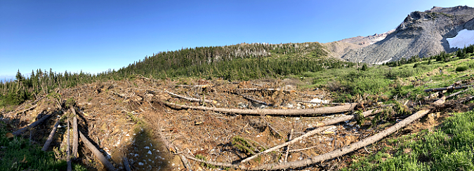
Panoramic view of the 2021 Elk Cove avalanche

[click here for a larger version of the panorama]

By early August, when these photos were taken, it would be easy to think the avalanche was just a pile of trees roaring down the mountain, but in fact, this debris is what’s left now that most of the snow and ice has melted away. Look closely, and you can see that a layer of snow and ice has yet to melt away from under the pile when this photo was taken:

6-10 feet of snow still remains under the debris pile as of early August

The 2021 avalanche dumped part of its debris on top of Cove Creek, but the stream made quick work of the pile over the winter. By summer, it had already melted an extensive tunnel under the mountain of snow, ice and debris (below).

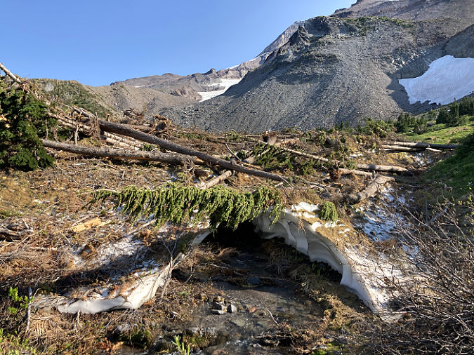
Cove Creek carved this snow cave under the debris pile following the avalanche

The huge pile of snow left in Elk Cove by the avalanche brought another surprise: some of the earliest blooming wildflowers were still just emerging in early August, thanks to the extra snow depth left behind by the avalanche. Among these was Western Pasque Flower, a species of Anemone that blooms within a couple weeks of snowmelt, and therefore rarely see by hikers. In fact, most know this beautiful wildflower by its whimsical seed heads, and by the name “Old Man of the Mountain”. The opening image in this article shows a field of Western Pasque Flower gone to seed.

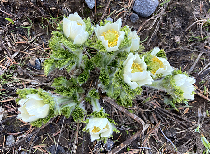
Normally an early bloomer, this Western Pasque Flower was in bloom in early August, thanks to the late-melting margins of the avalanche debris field

How often to avalanches like this occur at Elk Cove? Probably every winter, though events large enough to topple trees seem to occur every 10 years or so, depending on snowpack and weather conditions. Avalanches are most common in mid-winter, when weak snow layers and heavy snowfalls can cause snow to begin to slide on steep mountain slopes. Once they begin, avalanches can travel nearly 60 miles per hour, giving them the destructive force to level forests and buildings in their path.

Ghosts Hiding in Plain Sight

While the 2021 avalanche at Elk Cove is impressive, it is by no means unusual. A look at aerial photos between 2010 and 2021 shows that another avalanche swept through the same area in about 2015. Based on the orientation of downed trees from his earlier event, it originated on some of the same slopes on Barrett Spur that produced the last winter’s avalanche.

In the air photo comparison, below, the location of the new, 2021 avalanche debris pile is marked in yellow. When the 2010 air photo was taken, the forests at the center of the image were intact, but by the summer of 2016, an avalanche had clearly swept through the area. Based on the lack of reddish/orange debris in the 2016 image – the color of recently killed trees – suggests that this avalanche occurred at least a year earlier. So, for the purpose of this article, I’ve described it as the “2015 Avalanche”, and marked its extend in green.

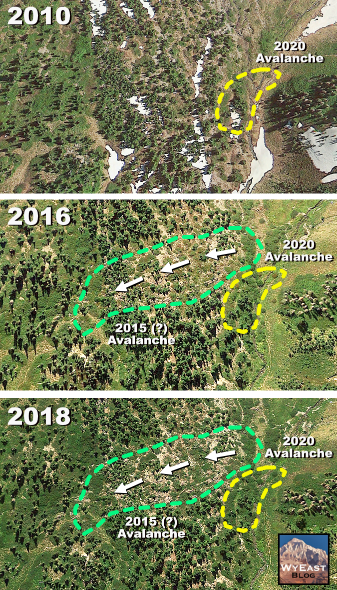
Air photos show the signs of a roughly 2015 avalanche that swept through the same part of Elk Cove as the 2021 event

In both the 2016 and 2018 views, the path of this earlier avalanche is clearly marked by downed trees that point in the direction (right to left) of the moving snow and ice. Though it impacted a larger area in the cove than the 2021 avalanche, the 2015 event brought less woody debris into the cove, suggesting that it originated on a less forested part of the west wall of Elk Cove. In fact, some of the trees in its path on the floor of the cove survived the avalanche, suggesting that the lack of woody debris in the 2015 event made it somewhat less destructive where it finally came to a stop.

While both of these avalanches are awesome reminders of the power of the elements in alpine country, Elk Cove has a few ghosts from the past that suggest much more fearsome events. Tucked into one of the mature, forested “tree islands” at Elk Cove is a ghost tree that give mute testimony to just how powerful an avalanche on Mount Hood can be. The stump of this ghost tree (below) is nearly four feet in diameter and was toppled many decades ago. 

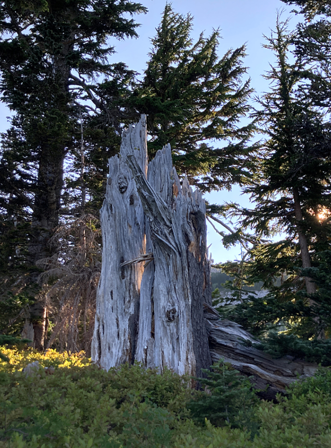
This giant ghost tree at Elk Cove was toppled long ago by a very large avalanche

This old ghost was once a very large Mountain Hemlock before it was toppled. Today, its broken remains could easily be 100 years old, marking an avalanche that might have preceded the arrival of the Timberline Trail and those 1930s CCC crews on Mount Hood. 

How do we know this old tree was destroyed by an avalanche? The telltale sign is where the tree was snapped off, marking the level of the winter snowpack when the avalanche swept through, and its top is pointed downslope, in the direction the avalanche was moving. Thanks to long, cold winters and dry summers, the shattered remains of this old tree (and several others like it in the cove) have survived to tell the story. 

Since that big avalanche, several good-sized trees have grown up around the old ghost tree, helping put an approximate date of 70-100 years since any avalanche of this scale has swept through the heart of Elk Cove. And though it has been many decades since that event, the days of these younger trees are surely numbered, too, as another epic avalanche in Elk Cove is inevitable.

How to Visit

If you’re an able-bodied hiker, you can visit Elk Cove most easily from the Vista Ridge trailhead. It’s a 9-mile hike round trip, but with well-graded trails and no glacial streams to navigate. If you visit the avalanche debris field, please tread lightly, as the rustic path that once led to the upper reaches of Cove Creek was partly buried with debris, and the surrounding area is covered with a fragile meadow of Western Pasque Flower.

You can find a trail description here in the Oregon Hikers Field Guide. Why, you might even know the author of this field guide entry..!

Tom Kloster | August 2021

After the Dollar Lake Fire

The Dollar Lake Fire from Bald Butte on September 3, 2011

On August 26, 2011, a lightning strike ignited what was to become the Dollar Lake Fire, on Mount Hood’s rugged north side. The fire started in the Coe Branch canyon, just below the Elk Cove trail, and was spotted by numerous hikers.

Initially, it seemed small and manageable. But over the next few days and weeks, arid conditions and strong winds spread the fire from Stranahan Ridge on the east to Cathedral Ridge on the northwest side of the mountain, eventually consuming some 6,300 acres of high elevation forest. The blaze burned through September and into early October, when fall rains finally arrived.

Hot spot erupts along Stranahan Ridge on September 3, 2011

Some of the burn was of the beneficial form, a mosaic fire leaving islands of surviving trees, but much of the fire was too hot and the accumulated forest fuel too plentiful to prevent devastating crown fires from sweeping across the forest. Eventually, the fire destroyed most of the standing timber and burned the forest duff down to mineral soil throughout most of the burn area.

The fire was contained entirely within the Mount Hood Wilderness, thanks to the recent Clear Branch additions that expanded the wilderness boundary on the north to encompass the Clear Branch valley and the high country surrounding Owl Point, to the north. While this complicated fire fighting, it has also created a living laboratory for forest recovery, as the USFS is unlikely to assist the reforestation process inside the wilderness boundary. The Forest Service map, below, shows the broad extent of the fire.

Final extent of the Dollar Lake Fire (outlined in red)

Though the fire burned to the tree line in several spots, a surprising amount of terrain along the iconic Timberline Trail was somehow spared. While the burn touched Elk Cove and Cairn Basin, WyEast Basin and Barrett Spur are well beyond the burned area. The Clear Branch wilderness additions to the north were mostly spared, as well.

The New Vista Ridge: After the Fire

The following is a photo essay from my first visit to the burn, on June 22, 2012, and is the first in what will eventually be a series of articles on the aftermath of the fire.

The devastation left by the fire is awesome to witness, but also starkly beautiful when you consider the context of a forest fire. After all, this event is part of the natural rhythm of the forest just as much as the changing of seasons.

From this point forward, we will have a front-row seat to the miracle of life returning to the fire zone, much as we’ve watched life return to the Mount St. Helens blast zone over the past 32 years. And as my photos show, the rebirth of the forest ecosystem has already begun on Mount Hood’s northern slopes.

Untouched trailhead at Vista Ridge.

From the Vista Ridge trailhead, I followed the Vista Ridge Trail to the snow line, above about 5,000 feet. The Vista Ridge trailhead is completely untouched, though the fire swept through a vast area immediately to the south. Yet, no sign of the fire is evident at the trailhead marker (above).

A bit further up the trail, at the Old Vista Ridge trailhead, the fire zone comes into view. Where green forests existed last summer, browned foliage and a burned forest floor spread out east of the junction. This fringe of the fire is of the healthy “mosaic” form, sparing large trees, while clearing accumulated forest debris.

Old Vista Ridge trailhead spared by fire… just barely.

An unexpected benefit of the fire came last fall, when the USFS added the long-neglected Old Vista Ridge trail to official agency fire maps (below) released to the public. Volunteers began restoring this beautiful trail in 2007, but formal acknowledgement of the route on USFS maps is a welcome development.

Welcome development: Old Vista Ridge trail reappears on USFS fire fighting maps

Clearly, the restoration of the Old Vista Ridge trail helped fire fighters reach this area, and could have served as a fire line had the blaze swept north, across the Clear Branch. Hopefully this is an indication that the Old Vista Ridge trail will someday reappear on the USFS maintenance schedule, too.

Turning south on the Vista Ridge trail from the Old Vista Ridge junction, the wilderness registration box and map board seem to have received divine intervention from the fire — the blaze burned within a few feet of the signs, yet spared both. From here, the Vista Ridge trail abruptly leaves the scorched fringe of the fire, and heads into the most devastated areas.

Vista Ridge trail signs were spared… by divine guidance?

A few yards up the Vista Ridge trail, the devastation quickly intensifies.

From about the 4,700 foot level, the Dollar Lake Fire burned the forests along Vista Ridge to bare earth. In this area, the entire forest crowned, leaving only a scattering of surviving trees where protected by topography or sheer luck. Forest understory, woody debris and duff burned to mineral soil, leaving a slick, muddy surface of ash. For those who have hiked through the previous Bluegrass Fire or Gnarl Fire zones on the east slopes of Mount Hood, this eerie scene is familiar.

The surprisingly intact trail curves through the devastated forests along Vista Ridge.

Crown fires have killed almost all of the standing forests along Vista Ridge.

Amid the devastation in this hottest part of the Dollar Lake Fire, signs of life are already emerging. At this elevation, one of the toughest survivors is beargrass, a member of the lily family with a deep rhizome that allows plants to survive even the hottest fires. These plants are normally evergreen, but were completely scorched in the fire. The new grown in this photo (below) has emerged this spring.

Beargrass (Xerophyllum tenax) emerges from underground rhizomes protected from the fire.

Another surprise is avalanche lily, one of the more delicate flowers in the subalpine ecosystem. Like beargrass, these plants survive thanks to a bulb located deep enough in the soil to escape the heat of the fire. As one of the early bloomers in the mountain forests, these plants area already forming bright green carpets in the sea of fire devastation (below).

Avalanche Lily (Erythronium grandiflorum) emerging from the ashes.

A ribbon of green, these Avalanche Lilies are emerging along the Vista Ridge trail.

Another of the beneficial aspects of the fire comes into view a bit further up the trail: several sections of Vista Ridge had long been overgrown with thickets of overcrowded, stressed trees that were ripe for a burn.

Over the coming years, these areas are likely to evolve into beargrass and huckleberry meadows like those found at nearby Owl Point or along Zigzag Mountain, where fires have opened the landscape to sun-loving, early succession plants.

Unhealthy forest thickets cleared by fire — a beneficial outcome of the blaze.

One human artifact was uncovered by firefighters — a coil of what must be telephone cable (below). This is a first along the Vista Ridge trail, but makes sense given the insulators and cable found along the Old Vista Ridge trail.

It’s hard to know what this connected to, but on the north end, it served the old Perry Lake Guard Station and lookout, just east of Owl Point. It’s possible this line extended to the Bald Mountain lookout, though I have been unable to verify this on historic forest maps.

Telephone cable on Vista Ridge – gathered up and coiled by firefighters?

Though much of the devastation zone still consists of blackened trees and soil, some of the burned forest has begun to evolve into the uniquely attractive second phase. This happens when scorched bark peels away from trees to reveal the often beautiful, unburned wood beneath.

Soon, all of the trees in this forest will shed their bark. The skeletons of thousands of trees will emerge in colors of red, yellow and tan, then gradually fade to a bleached gray and white with time.

The burned trees of Vista Ridge are just beginning to shed their blackened bark, revealing beautiful trunks unscarred by the fire.

Mount Hood rises behind the new ghost forests of Vista Ridge

This second phase of the fire is helped along by winter snow. As the scene above shows, the freeze-thaw and compacting effects of the snow pack have already stripped many trees of their bark beneath the now-melted snowpack. Hot summer sun will continue this process, shrinking the remaining bark until it drops from the drying tree trunk.

This process of de-barking is the first in a post-fire sequence of events that will recycle much-needed organic matter to the forest floor. Twigs and tree limbs will soon fall, and over time, whole trees will begin to drop. This is a critical phase in stabilizing the forest soil, when low vegetation is still just beginning to re-establish in the fire zone.

Strips of tree bark are the first organic layer to accumulate on the floor of the burn zone.

The next few images show the extent of the Dollar Lake Fire, as viewed from Vista Ridge. To the east (below), The Pinnacle was mostly burned, but the fire somehow missed stand of trees just below the north summit.

These trees will play an important role in reforestation of the area, partly because so few trees survived the fire, but also because of their geographic location above the surrounding forest, where wind will widely scatter their seeds.

The Pinnacle, where a small grove of of trees on the north slope survived the fire.

To the south, the area above Elk Cove known as 99 Ridge (shown below) was partly spared, though the fire did scorch the east slopes of the ridge. From this side (to the west), the Timberline Trail corridor was almost completely spared. Ironically, Dollar Lake — the namesake for the fire — appears to have been spared, as well.

To the west of 99 Ridge, WyEast Basin was also spared, but the area along the Timberline Trail to the west of the basin, along the upper sections of Vista Ridge, was largely burned.

Forests along 99 Ridge were spared by the fire.

This panoramic view (below) encompasses the entire mid-section of the fire, from Stranahan Ridge on the horizon to Vista Ridge, on the right. This is a new viewpoint along a largely unnoticed rocky scarp on the east shoulder of Vista Ridge, now revealed thanks to the fire.

(Click here for a much larger panoramic view]

A Changed Landscape

Those who have explored Mount Hood’s north slopes over the years will surely mourn the loss of the beautiful forests of noble fir and mountain hemlock that once stood here — I certainly have. But this is also a chance to watch the ecosystem recover and restore itself over time, as it has for centuries. Among the surprising benefits are the new scenic vistas that are suddenly available, giving a bit more meaning to the name “Vista Ridge.”

The new views from Vista Ridge include Laurance Lake and Bald Butte, to the east.

By following the true ridge top of Vista Ridge, the new views extend east across Laurance Lake and the Clear Branch valley to Bald Butte and the Columbia Basin (above). Most of the area below the ridge is not burned, and this new perspective on the recent additions to the Mount Hood Wilderness is both unexpected and beautiful.

To the north, the new views include the rugged and little-known Owl Point area of the expanded Mount Hood Wilderness (reached by the Old Vista Ridge trail). Mount Adams rises in the distance, above the talus fields and meadows of Owl Point.

Owl Point and Mount Adams from newly revealed viewpoint on Vista Ridge.

This suddenly very scenic “true” ridge along the lower portion of Vista Ridge is easy enough to hike by simply following the ridge top where the existing trail heads into a narrow draw, about one-half mile from the Old Vista Ridge trail junction. It’s worth the visit if you’d like to inspect the scenery and Dollar Lake Fire up-close.

But in the spirit of recasting the Vista Ridge trail in the aftermath of the fire, and taking in these new views, now would be the perfect time to simply realign the trail along the ridge top. As shown on the map (below), this project could be done in a weekend by volunteers, if approved by the Forest Service.

(Click here for a larger map]

The fire has already done the heavy work of trail building by clearing the ground to mineral soil: designing and completing a realigned trail here would be quite straightforward. The slope of the ridge top, itself, is surprisingly gentle and would allow for an easy grade, similar to the current trail.

I hope to pitch this idea to the Forest Service, so if you’re interested in getting involved, watch the Portland Hikers forum for updates. That’s where volunteer work parties will be organized if there is interest from the USFS.

Until then, take the time to explore the fire zone, and watch the unfolding forest recovery firsthand. Visit the Portland Hikers Field Guide for directions to the Vista Ridge Trailhead.