Building the Timberline Trail

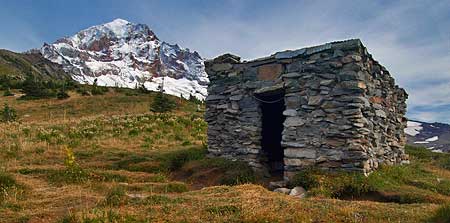
The McNeil Point Shelter.

For decades, hikers and backpackers have taken Mount Hood’s famous Timberline Trail for granted — and why not? It was one of the earliest alpine hiking trails in the American West, and seems to have evolved with the mountain itself.

But the story of the trail is one of an original vision that has been realized in fits and starts, and the story is still unfolding.
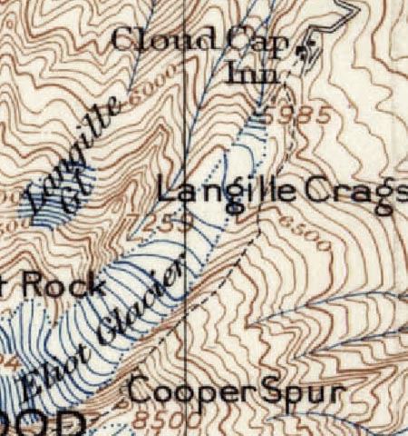
The first recreational trail on Mount Hood followed the South Eliot Moraine from Cloud Cap Inn to Cooper Spur, as shown on this 1911 map.

The first modern trail on Mount Hood was established in 1885, beginning at David Rose Cooper’s tent camp hotel, located near the present-day Cloud Cap Inn. The route followed the south Eliot Moraine to his namesake Cooper Spur. Soon thereafter, the Langille family would lead hikes and climbs on this route from the new Cloud Cap Inn, completed in 1889.

The Langilles also established a route from Cloud Cap to Elk Cove for their visitors, completing another section of what would someday become the Timberline Trail.
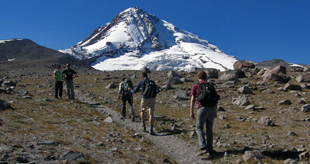
Hikers climbing toward Cooper Spur along one of the original sections of the Timberline Trail.

The route remains a popular trail, today, though it has never been formally adopted or maintained by the Forest Service. The first leg of this trail briefly functioned as a segment of the Timberline Trail, thanks to a temporary re-routing in the mid-2000s (more about that, later).

The significance of the original Cooper Spur trail is that it was built entirely for recreational purposes, the first such route on the mountain.
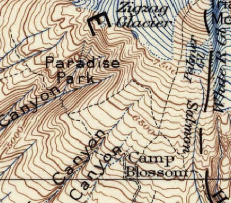
Camp Blossom was built some fifty years before Timberline Lodge was opened in 1938, but established the same network of trails that have since served the lodge.

Other hiking routes soon followed on the south side of the mountain, connecting the former Camp Blossom to nearby Paradise Park and the White River canyon. Camp Blossom was built by a “Judge Blossom” in 1888 to cater to tourists. The camp was at the end of a new wagon road from Government Camp, and located near present-day Timberline Lodge. It was eventually replaced by the Timberline Cabin (1916), and later, Timberline Lodge (1938).

The informal network of alpine trails radiating from Camp Blossom in the late 1800s still forms the framework of trails we use today. This is especially true for the nearly 7 miles of trail from White River to Paradise Park, which largely defined the Timberline Trail alignment in this section.
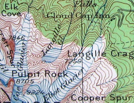
By the 1920s, the Langille family had developed trails from their Cloud Cap Inn to nearby Elk Cove (1924 USGS map).

By the 1920s, the Mazamas and other local outdoor clubs were pushing for more recreation facilities around the mountain, and public interest in a round-the-mountain trail was growing.

By this time, new Forest Service trails had been built on the north side of the mountain from the Clear Branch valley to Elk Cove and along Vista Ridge to WyEast Basin. These trails were connected at timberline (with a spur to Dollar Lake), creating another segment of what was to become the Timberline Trail. Combined with the route from Cloud Cap to Elk Cove, nearly 8 miles of the future Timberline Trail had been built on the north side of the mountain by the 1920s.
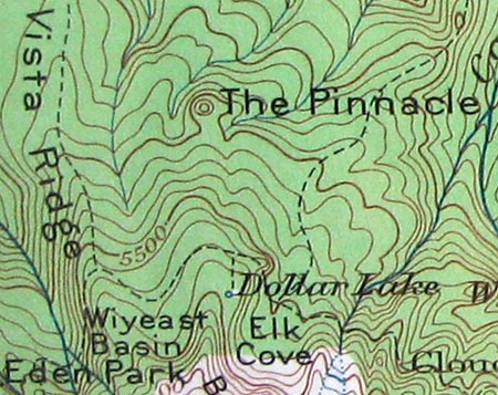
By the 1920s, the Vista Ridge and Elk Cove trails were established, extending the emerging Timberline Trail from Cloud Cap to Eden Park (1924 USGS map).

The Timberline Trail is Born

The concept of a complete loop around the mountain finally came together in the 1930s, during the depths of the Great Depression, when Franklin Delano Roosevelt’s New Deal recovery program, and the Civilian Conservation Corps (CCC), brought the needed manpower and financial resources to the project.

The CCC completed the new 37.6 mile Timberline Trail in 1934, stitching together the existing north side and south side trails, and covering completely new terrain on the remote west and east sides of the mountain.
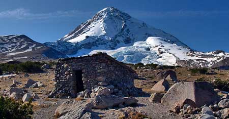
The venerable Cooper Spur shelter still stands on the slopes above Cloud Cap, maintained by volunteers.

The Corps built a generous tread for the time in anticipation of heavy recreation use. The new trail was built 4 feet wide in forested areas, 2 feet wide in open terrain, and gently graded for easy hiking.

The trail was marked by square cedar posts placed at rectangular intervals over open country and by blazes in forested areas. Many of the distinctive trail posts survive between Cloud Cap and Gnarl Ridge, mounted in huge cairns.

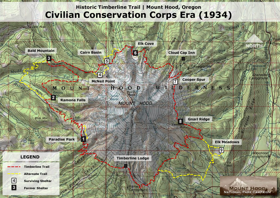
Shelters were built along the trail by the CCC crews as a place for hikers to camp and rest, and as protection against sudden storms. Most are of the same stone design, with a small fireplace and chimney. They were built with steel rafters instead of wood so that the structures, themselves, would not be used as firewood in the treeless high country, and also to withstand heavy winter snows. Of the six original stone structures, only those at McNeil Point, Cairn Basin and Cooper Spur survive (see large version of map, below).

Map of the completed Timberline Trail and CCC era shelters.

(Click here for a large map)

Three wood structures were also built along lower sections of trail, at Ramona Falls, Bald Mountain and Elk Meadows. Of the three, only the rapidly deteriorating structure at Elk Meadows survives.

The completed trail featured a couple of oddities: the McNeil Point shelter had been constructed on a high bluff above the Muddy Fork that was eventually left off the final trail alignment, due to concerns about maintaining the trail at this elevation. Today, thousands of hikers nevertheless use the partially completed trail each year to reach the historic shelter and spectacular viewpoint.

Curiously, the shelter at Elk Meadows was also built off the main loop, perhaps because at the time, the meadows were seen as much a place to graze packhorses as for their scenic value. Like McNeil Point, this “forgotten” shelter continues to be a very popular stop for hikers, today.
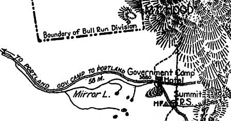
This 1921 map shows the Oregon Skyline Trail terminating at Mount Hood, before construction of the Timberline Trail. Note the early Bull Run Reserve encompassing the entire west side of the mountain.

By the late 1930s, much of the new Timberline Trail had also been designated as an extension of the Oregon Skyline Trail — according to maps from the time (above), the Skyline had previously terminated on the slopes of Mount Hood, above Government Camp.

The expanded Skyline Trail arrived at the Timberline Trail from the south, near Timberline Lodge, turned east and traced the new Timberline Trail counter-clockwise around the mountain before descending to Lolo Pass, then headed north to Lost Lake and the Columbia Gorge.

1970s Trail Renaissance

A third major era of trail construction on the mountain came in the 1960s and 1970s, when several major re-routes of the Timberline Trail were built.

By the early 1960s, the Oregon Skyline Trail had been relocated to the west side of the mountain, following the Timberline Trail from Timberline Lodge north to the Bald Mountain Shelter, then on to Lolo Pass.

By the time the Pacific Crest Trail was established in the 1968 National Trails Act, absorbing the old Skyline Trail, a new route across the Muddy Fork canyon was in the works for the Timberline Trail.
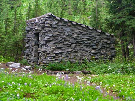
The Cairn Basin stone shelter is the best-preserved of the CCC-era structures, thanks to more protection from the elements than most of the original buildings.

By the early 1970s, this new section rounded Yocum Ridge from Ramona Falls, crossed both branches of the Muddy Fork, then ascended to the steep meadows of Bald Mountain, one of the most popular Timberline Trail destinations today.

The new Muddy Fork segment is now part of the Timberline Trail loop, with the Pacific Crest Trail following the old Timberline Trail/Oregon Skyline Trail alignment. Though less scenic, the old route is more direct and reliable for through hikers and horses.

In contrast, the scenic new route for the Timberline Trail has been a challenge for the Forest Service to keep open, with the Muddy Fork regularly changing channels, and avalanche chutes on the valley walls taking out sections of trail, as well.
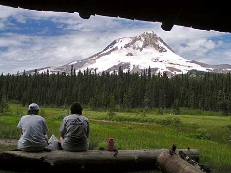
Going, going… this view from the slowly collapsing Elk Meadows shelter will soon be a memory. This is the only remaining wood shelter of three that were built by the CCC.

In the 1970s, a section of trail descending the east wall of Zigzag Canyon was also relocated, presumably as part of meeting Pacific Crest Trail design standards. While the old route traversed open, loose slopes of sand and boulders, the new trail ducks below the tree line, descending through forest in gentle switchbacks to the Zigzag River crossing of today.

At Paradise Park, a “low route” was built below the main meadow complex, and the headwater cliffs of Rushing Water Creek. Like the Zigzag Canyon reroute, the Paradise Park bypass was presumably built to PCT standards, which among other requirements, are intended to accommodate horses.

The north side of the mountain also saw major changes in the early 1970s. The original Timberline Trail had descended from Cathedral Ridge to Eden Park, before climbing around Vista Ridge and up to WyEast Basin. The new route skips Eden Park, traveling through Cairn Basin, instead, and climbing high over the crest of Vista Ridge before dropping to WyEast Basin.

Beautiful meadow views line the “new” Vista Ridge trail section completed in the early 1970s.

Finally, a section of trail near Dollar Lake was moved upslope, shortening the hike to the lake by a few hundred yards, and creating the sweeping views to the north that hikers now enjoy from open talus slopes east of Dollar Lake. Just beyond Dollar Lake junction, the descent into Elk Cove was also rebuilt, with today’s long, single switchback replacing a total of six on the old trail which descended more sharply into the cove.

In each case, the new trail segments from the early 1970s are notable for their well-graded design and longer, gentler switchbacks. While the main intent of the trail designers was an improved Timberline Trail, the new segments also created a numerous new routes for day hikers who could follow new and old trail segments to form hiking loops. These loops are among the most popular hikes on the mountain today.

The Future?

The retreat of Mount Hood’s glaciers in recent years has destabilized the outwash canyons, and in the past two decades, massive debris flows have buried highways and scoured out streambeds. One of the oldest segments of the Timberline Trail, near Cloud Cap, has been disrupted by washouts for nearly a decade, and is now completely closed, thanks to a huge washout on the Eliot Branch in 2007.

Sign from the first re-route, posted in 2001. Now the trail is completely closed at the Eliot Branch.

The Forest Service has since struggled to find funding to reconnect the trail at the Eliot Branch. The first washout moved the stream crossing uphill, taking advantage of the original Cooper Spur path established in the 1880s, then crossing to a parallel climbers path on the north moraine of the Eliot Glacier.

This temporary crossing lasted a for a few years in the early 2000s before the massive washout in 2007 permanently erased this section of trail. This portion of the loop as since been completely closed, though hundreds of hikers each summer continue to cross this extremely unstable, very dangerous terrain.
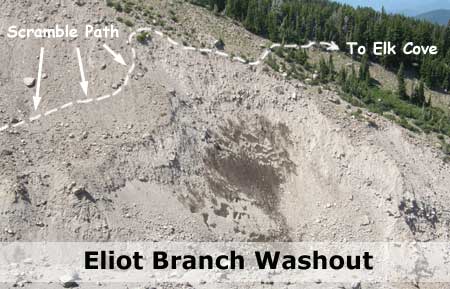
Site of the Eliot Branch washout and closure -- and the risky route hikers are taking, anyway.

The growing volatility of the glacial streams will ultimately claim other sections of trail, creating an ongoing challenge for the Forest Service to keep the Timberline Trail open each summer.

If repairing the washouts along the trail were as costly as those along the nearby Mount Hood Loop Highway, then there might be some question of whether it makes sense to keep the trail open. After all, millions of dollars are being spent this year to rebuild the Mount Hood Highway bridge over White River, yet again, in an area that has had repeated washouts.

Hikers crossing the Eliot Branch before the 2007 washout.

By comparison, a wilderness trail is exceptionally cheap to build, and much less constrained by topographical or environmental concerns than a road. It really just comes down to money and priorities, and the Forest Service simply doesn’t have the funding to keep pace with the growing needs of the Timberline Trail. With even a modest increase in funding, the trail can be rebuilt and adapted to periodic washouts, or other natural disturbances.

Speaking Up

One way to have an impact on the funding situation for the Timberline Trail is to weigh in with your Congressman and Senators. While the current political climate says that earmarks are dead, history tells us otherwise: ask for an earmark for the Timberline Trail. After all, the trail is historic and an international draw that brings tourists from around the world to help boost local economies.

If you’re not an earmark fan, then you can argue for an across-the-board funding boost for forest trails as a job-producing priority in the federal budget. A ten-fold increase over current levels would be lost in rounding areas in the context of the massive federal budget.

Yet another angle are the health benefits that trails provide, particularly given the federal government’s newly expanded interest in public health. This is emerging as the best reason to begin investing in trails, once again.
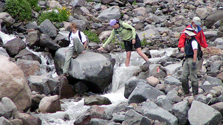
Hikers negotiating the Muddy Fork crossing after the 2002 debris flow swept through the canyon.

Of particular interest is the fact that Oregon Congressmen Earl Blumenauer and Greg Walden actually hiked the loop, just before the 2007 Eliot Branch washout. One is a Democrat, the other Republican, so you can cover your bipartisan bases with an e-mail both! They share the mountain, with the congressional district boundary running right down the middle, so both have an interest in the Timberline Trail.

Finally, Oregon Senator Ron Wyden championed expanded wilderness for the Mount Hood area for years, and President Obama finally signed the bill into law earlier this year. So, another angle is to argue for the needed funding to support trail maintenance in these new wilderness areas, especially since they will require more costly, manual maintenance now.

It really makes a difference to weigh in, plus it feels good to advocate for trails with your Congressional delegation. Here’s a handy resource page for contacting these representatives, and the rest of the Oregon delegation:

Here’s how to send an e-mail to Congress

Thanks in advance for making your voice heard!
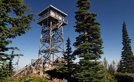
Flag Point Lookout

In the early days at the turn of the 20th Century, the U.S. Forest Service was primarily a security force, tasked with guarding our public lands from timber thieves and squatters. This role expanded to include fire suppression in the early 1900s, a move that we see today as ecologically disastrous, but at the time, responded to massive fires destroying living trees that were valued in board feet, not biology.

The most enduring legacy from this era was the construction of thousands of fire lookouts, hundreds of forest guard stations and a sprawling network connecting trails and primitive dirt roads.

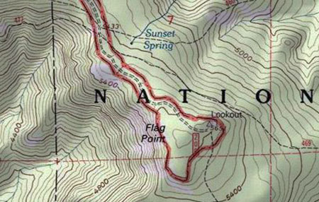
Though the lookouts and guard stations are mostly gone, the trail network still survives as the backbone of today’s recreation trail system. A few trails still lead to surviving lookouts scattered across the country. This article describes one such survivor, the Flag Point Lookout, located at 5,636 feet on a rocky, flat-topped bluff two miles east of Lookout Mountain.

The primitive road to Flag Point is surrounded on three sides by the Badger Creek Wilderness

The Flag Point Lookout is unique in that it continues to serve as an active fire lookout during the summer. The view from the lookout surveys a broad sweep of the eastern slopes of Lookout Mountain, far into the Eastern Oregon sagebrush and ranchland, and south into the rugged Badger Creek Wilderness.

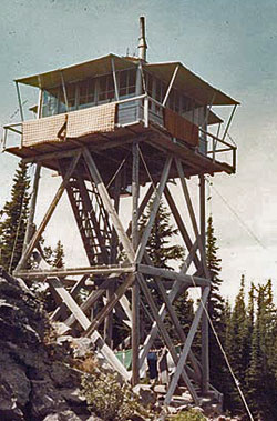
The second structure on Flag Point was this L-4 cabin constructed in 1932, and later replaced by the current structure

Since the establishment of the Badger Creek Wilderness in 1984, The Flag Point lookout and the long, rugged 1930s-era dirt road leading to it have been surrounded on three sides by federally protected wilderness (The same 1984 legislation left two other surviving lookouts in the Mount Hood area, the Devils Peak and Bull of the Woods towers, inside new wilderness areas, where they are now maintained by volunteers as hiking destinations).

The first lookout structure at Flag Point was a six-foot square cabin on a 40-foot pole tower, built in 1924. It must have been terrifying in rough conditions, and was soon replaced with the popular L-4 style cabin (pictured above) on a 30-foot pole tower in 1932, a design that was found across Oregon.

Later improvements to the second tower were made in 1955, and a series of outbuildings were added over the years, replacing the original tent camp that accompanied the first structure.

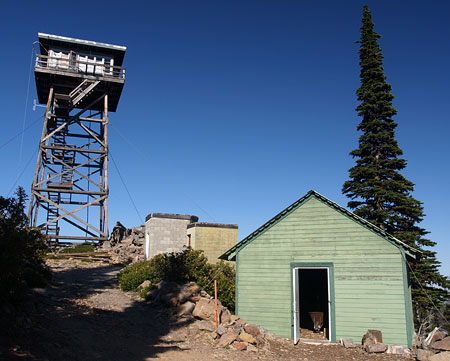
The current lookout tower and outbuildings at Flag Point

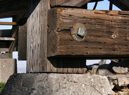
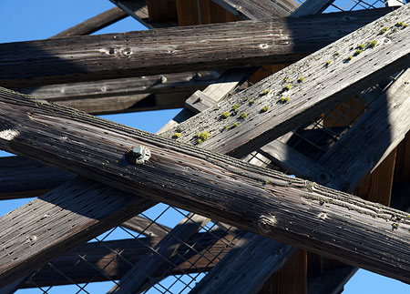
In 1973, the third and current lookout structure was built — an R-6 flat top cabin on a 41-foot tower constructed of sturdy, pressure-treated cross-timbers. Like many lookouts, the structure is primarily held in place by stay cables, and simply rests upon its four concrete foundation feet.

Though the current structure is still too young to be listed on the National Historic Register, it has been listed on the National Lookout Register. It will become eligible for the historic register in just 13 years, in 2023.

Amazingly, the tower is anchored by cables, and simply sits upon its four foundation piers

The Flag Point Lookout is also notable for the remarkable forest ecosystem that surrounds it, where stands of fir and mountain hemlock blend with western larch and ponderosa as east meets west. The rain shadow effect of the Cascade Range is plainly visible from Flag Point, where the sweeping view extends far into the sagebrush deserts of Eastern Oregon.

Ironically, these are fire forests, an ecosystem that has specifically evolved around wildfire cycles, and thus have suffered greatly from the well-intended “protection” from fire that the lookouts have provided. Today, natural fires in the Badger Creek Wilderness are likely to be allowed to burn, with the Forest Service intervening only when homes or private property outside the wilderness are threatened.

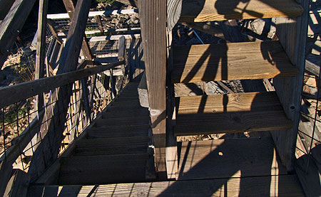
The plank staircases are beautifully constructed with rabbet and dado joints, and enclosed with galvanized steel mesh

Beneath the forest canopy, the wildflowers of Flag Point are as diverse as the conifers, with mountain and desert species mingling in the sunny, open meadows. The Divide Trail, connecting Flag Point to Lookout Mountain, provides one of the best wildflower hikes in the region in early summer, traversing through miles of meadows and rock gardens along the way.

Flag Point was an important forest destination in its time, and still serves as the hub for several forest trails that are a legacy of the early lookout era. In addition to the Divide Trail, the lookout has trails radiating to Ball Point, Gordon Butte and Badger Creek. Today, most visitors to the lookout arrive via the access road, but hikers and horse packers also regularly visit the lookout from this network of wilderness trails.

The key to the design of the Flag Point tower is a sturdy maze of treated cross-timbers

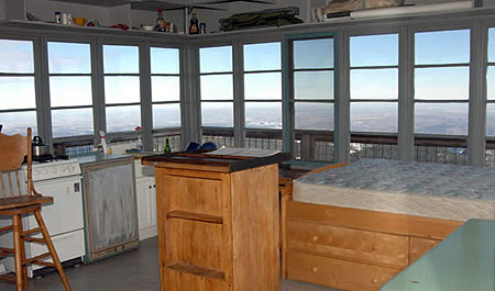
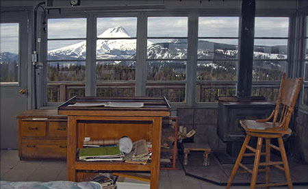
The cabin atop the Flag Point lookout consists of a 14-by-14 foot interior, surrounded by an airy exterior catwalk. Steel mesh fills the gap between catwalk railings, adding some degree of confidence for vertiginous visitors.

The small cabin is furnished with a bed, a wood stove for heat, gas cook stove, table and chair, and a solar lighting system — a modern amenity that early lookouts couldn’t have imagined.

Looking east, the view extends beyond the Cascades and across the Oregon desert country (USFS Photo)

At the center of the cabin is a map table that echoes the original Osborne fire finders used to pinpoint fire locations. Outside, a rope and pulley system is used to haul supplies and firewood to the catwalk from the base of the tower.

Water for drinking, cooking and washing must be hauled in to the tower by truck, though early lookouts simply carried water from the nearby Sunrise and Sunset springs. Outbuildings include an outhouse, woodshed and an A-frame communications shack has been added to the west of the tower.

The view to the west provides a spectacular look at Mount Hood and nearby Lookout Mountain (USFS Photo)

Visiting the Lookout

Anyone can visit the Flag Point Lookout by simply parking at the locked gate, and hiking about one quarter mile to the lookout complex. The tower is generally staffed from June 1 through October 15, so be courteous and let the lookout know you’re visiting before climbing the tower. If you’re lucky, the lookout will be on site and invite you up for a tour. If the tower is closed, you can still climb to the lower catwalk for a close-up look at the structure, and views of the surrounding terrain.

The Flag Point lookout also makes for an interesting add-on to the Divide Trail hike to Lookout Mountain. You can simply hike to the lookout along the Flag Point Road from the Divide Trail (about 3/4 mile each way), or shuttle your car to the gate, saving about a mile of road hiking, round-trip.

In winter, the Forest Service rents the lookout cabin to skiers looking for a rugged, remote experience. Of the handful of lookouts open as winter rentals, the Flag Point Lookout is one of the most challenging to reach. You can learn more about winter rentals at the lookout here.

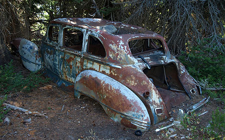
Relic from a bygone era, this 1940s DeSoto is slowly fading into the forest near Flag Point, where it was mysteriously parked decades ago

How to Get There

Reaching the lookout is an adventure in its own right. The last few miles of forest roads are generally open from June through October. From Portland, drive east on US 26 through Government Camp, then follow Highway 35 across the White River, and down the East Fork Hood River valley, beyond the Meadows ski resort.

Turn east (right) on Road 44, where signs point to Dufur and Camp Baldwin, and follow this paved road for 8 miles to the poorly marked junction with Road 4420. Turn south (right) and follow this paved forest road as it eventually curves past the Fifteenmile Campground. Just beyond the sharp bend at the campground, watch for dirt road No. 200, heading abruptly uphill and to the right. This is the Flag Point road, and it bumps along for the next 3.5 miles to the lookout gate. Parking is available near the gate.

Note: unfortunately, the Forest Service has recently ditched this road with a series of water bars that make for very slow going, and make the trip a rough ride for passenger vehicles – take it slowly!

Hiroshima Rock Centennial (1910-2010)

Hiroshima Rock and Mount Hood

Today marks the centennial of a Japanese climbing expedition to the summit of Mount Hood on July 17, 1910. The achievement would probably be forgotten by now, except for the visitors carving a record of their ascent into a glacier-polished andesite boulder at the crest of Cooper Spur.

The boulder is now informally known as “Hiroshima Rock”, and a familiar feature to generations of hikers and climbers who have since passed this spot.

Detail of Hiroshima Rock

Little is recorded about the expedition, even in the gold standard of Mount Hood history — Jack Grauer’s Complete History of Mount Hood — though the arrival of a Japanese climbing expedition surely must have been reported in the local press of the time. Lacking that written history, what follows is my own speculation on the climb.

The inscription contains both English and Japanese text, and supposedly the Japanese portion identifies the expedition as originating from Hiroshima. It is not surprising that a Japanese expedition would seek out Mount Hood. Mountain climbing had blossomed as a sport in Japan in the late 1800s, just as it had in Europe and the United States.

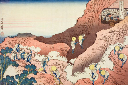
But the Japanese interest in climbing mountains had deeper roots, dating back centuries to the earliest spiritual pilgrimages to mountain peaks — most notably, Fujiyama.

“The Pilgrimage” captures the long Japanese tradition of mountain climbing for spiritual purposes

It is therefore not surprising that a group who had likely climbed Mount Fuji numerous times was drawn to Mount Hood, on the opposite side of the Pacific. Both peaks are part of the Pacific “Ring of Fire”, and share a common volcanic origin. Yet, Mount Hood would have been a more technical climb, with its steep, deeply eroded slopes and tumbling glaciers.

It is also likely that the Japanese party stayed at Cloud Cap Inn, or at least stopped there, since the inn was still operating in 1910, under the management of Horace Mecklem, and would have likely been snow free in mid-July. At the time, the Cooper Spur route was the most popular ascent, since Cloud Cap Inn provided the best access to the mountain.

Traditional Japanese spiritual quest to Fujiyama

Given the very active climbing schedule of the Mazamas in the early 1900s, it is also likely that the Mazamas were involved in the Japanese expedition, or at least aware that a group from Japan was on the mountain.

The Japanese expedition likely used similar climbing tools to what Europeans and Americans employed at the time: layered clothes, knapsacks and alpenstocks. The photos below are LIFE archival images from the late 1940s that capture the look and feel of Japanese climbs just after the war. These images probably give a fair sense of what the 1910 climbers must have looked like.

Japanese climbing expedition on Fujiyama in 1948

Japanese climber on Fujiyama with Lake Kawajuchi in background in 1948

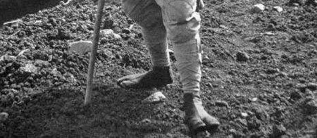
The second image from the LIFE series is interesting in that it shows the climber wearing traditional Japanese tabi, or toe shoes (see detailed view, below). Modern tabi are still widely worn today in Japan, and as anyone who hikes knows, modern toe shoes are a popular new trend in the U.S., too.

Detail showing a Japanese climber wearing tabi, or toe shoes

So, why did the expedition carve their record into the rock on Cooper Spur? The most obvious explanation is simply posterity, since it was common in that era to carve your legacy into rocks or trees in a way that we would find unacceptable today.

But a more intriguing possibility might be that that expedition was holed up on Cooper Spur, perhaps stalled by bad weather, or simply setting up a base for the final ascent. This might explain the time it would have taken to chisel the Hiroshima Rock message into a very hard chunk of andesite — an effort that would likely take hours to complete.

For now, the details appear to be lost in time. But the legacy of the inscription is an elegant reminder that attraction of Mount Hood drawn visitors from around the world from the very beginning, and still does.

Postscript

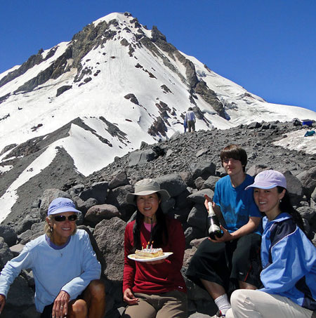
Chiyoko & friends celebrating at Cooper Spur (Photo Courtesy Guy Meacham)

Just after posting this article, I learned that Guy and Chiyoko Meacham led a group up to Hiroshima Rock on July 18, 2010 to celebrate the centennial (plus one day) and Chiyoko’s birthday (to the day). After cake and champagne, Chiyoko translated the Kanji inscriptions to read:

Left side: Mie Ken Jin – Ito (Person from Mie State, [Mr.] Ito)

Right side: Hiroshima Ken Jin (Person from Hiroshima State)

English portion:

July 17th 1910
Monument
[Mr.] S. Takahashi

You can read the entire trip report and see their beautiful photos over at the Portland Hikers site: click here

Illuminating Mount Hood

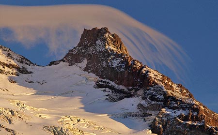
A lenticular cloud hovers over Illumination Rock on a warm August evening

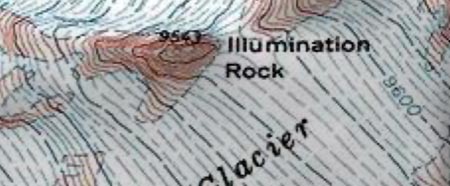
Visitors to Timberline Lodge cannot help but notice the huge monolith on the southwestern shoulder of Mount Hood parting the Reid and Zigzag glaciers. This 9,543 foot spire is Illumination Rock, and a signature feature on the mountain.

What few visitors know is that the rock gained its name in the early days of mountaineering on Mount Hood, when a series of expeditions were made to illuminate the mountain so that it might be seen from Portland.

Several of the early lighting schemes focused on the steep saddle above Illumination Rock, though other spots were attempted over the years, including the crater and even the summit of the mountain.

Illumination Rock and saddle, above the Zigzag Glacier

In modern times, such a scheme would involve riding a snow-cat loaded with fireworks from Timberline Lodge to the edge of the Zigzag Glacier, then using skis or sleds to reach Illumination Rock. But in the late 1800s, this effort was much more daunting.

The trip began with a day-long wagon (or horseback) ride from Portland to Government Camp on the old Barlow Road. From there, the expeditions spent the next two days hauling their explosives up the 6,000 feet and six miles to Illumination Rock – there was no convenient road to timberline, and no lodge there, yet.

Some of the expeditions used horses to pull heavy sleds, while others relied on human power to carry the fireworks to the top of the mountain. In the 1800s, the Zigzag Glacier also presented a more dangerous barrier than exists in modern times. The glacier was much larger, and the illumination teams were very much in danger of falling into crevasses.

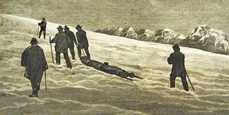
Illustration from the 1887 expedition

The early adventurers also lacked communication that we take for granted today. A modern illumination effort would almost surely rely on cell phones for coordination and safety, while the early efforts relied on pre-arranged times to communicate with signal flares and mirrors.

The first recorded illumination occurred in 1870, when Perry Vickers climbed to the summit and set off several magnesium flares to celebrate July 4. The displays were seen from below on the mountain, but not from Portland.

Vickers campaigned for a larger display with potential financial backers in Portland, and staged a second display of flares in 1873. Attempts by other groups in 1877 failed due to the extreme conditions on top of the mountain. So far, no display had been seen from Portland.

The 1887 Expedition

On July 1, 1887, a blue ribbon expedition departed for Mount Hood with 100 lbs of flammable “red fire” powder and a plan to illuminate the mountain on the evening of July 4. The expedition was led by William Gladstone Steel, the legendary “Father of Crater Lake National Park” and irrepressible force of nature in his time.

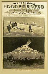
1887 photo essay

Steel’s group reached Government Camp on July 2, and established a base camp high on the mountain the next day, after a difficult and sometimes harrowing trip up the mountain. The weather was bitterly cold on July 4 when the party made the final ascent to Illumination Rock, crossing the treacherous Zigzag Glacier.

Steel and Dr. J.M. Keene set up a high camp near the rock, where the illumination would occur. The rest of the party descended back to the base camp below timberline to watch and wait for dark to fall, and the scheduled lighting of the mountain. Steel and Keene finally lit the red fire powder at 11:30 PM, and the display on the mountain was easily seen from Portland, Salem and many other communities around the mountain.

The adventure for Steel and Keene did not end there, however. Upon their nighttime descent from the rock to the base camp, the pair slipped partway into a crevasse while crossing the Zigzag Glacier. After this narrow miss, they became disoriented, and missed the base camp by a mile, spending most of the night in an improvised camp below timberline before the searchers from the rest of the expedition found them.

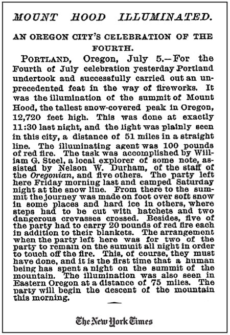
New York Times account of the July 4, 1887 illumination

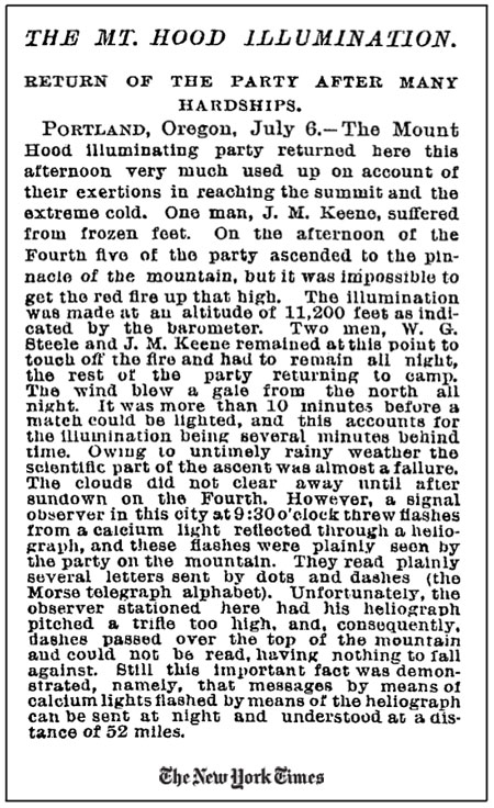
The story of the first successful lighting of Mount Hood on July 4, 1887 was a local sensation, and was recounted in newspapers around the country (see New York Times accounts, above and below). The success of the 1887 effort led to a repeat climb in 1888, also led by Will Steel, and several subsequent efforts over the years that followed.

New York Times account of the July 4, 1887 illumination

1969 Mazama project

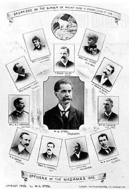
The last formal illumination effort came in 1969, celebrating the 75th anniversary of the founding of the Mazamas. Compared to the earliest attempts, this lighting extravaganza was modern in every way, but the William Gladstone Steel connection persisted: Steel was a founder and elected the first president of the Mazamas when the club formed on the summit of Mount Hood in 1894.

The 1969 expedition carried boxes of flares, mortars and rockets to the 9,000 foot level of the mountain in a snow-cat, then teams of Mazamas went to work carrying the fireworks to designated spots around the crater and along the summit ridge. Dozens of rockets and hundreds of flares were positioned for the display.

William Gladstone Steel and the first Mazama board in 1895

On the evening of July 19, interviews with climb leaders were broadcast live on a Portland radio station. Later, Governor Tom McCall dedicated the lighting ceremony by telephone, paying tribute to the fact that, on that day, the Apollo 11 astronauts had just landed on the moon, which shone full on Mount Hood that night.

The Mazama lighting was the most spectacular in the history of the illumination efforts, lasting nearly ninety minutes, and lighting the mountain for miles in all directions. Consistent with the modern times and their stewardship mission, the Mazamas volunteers spent the next day carefully retrieving mortars and spent flares from the slopes of Mount Hood, removing all traces of the lighting from the mountain.

The Legacy

Given the expanded wilderness protections that now encompass much of the mountain, it is unlikely that we will ever see another illumination of Mount Hood. Instead, we are left with news accounts, sketches and photographs of a bygone era — though Mount Hood may someday emerge from dormancy, and provide some lighting of her own!

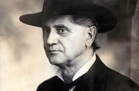
William Gladstone Steel in the late 1800s

According to Oregon Geographic Names, it was the first successful illumination of the mountain in 1887 that gave Illumination Rock its name, though many illumination efforts took place near the rock over the years.

For his part, William Gladstone Steel was honored by the naming of Steel Cliff, the wall of rock that frames the east side of the crater, and that was lit up by many of the illumination displays. Steel is also honored for his relentless 17-year effort to create a national park at Crater Lake by the naming of Steel Bay, along the north shore of the lake.

With these names on our modern-day maps, we are forever reminded of the unique spirit and imagination of the early mountain explorers.

The Mount Hood Quarter

Beginning this year, the new America the Beautiful Quarters program will release the first of 56 new United States quarter coins. The new coins feature national parks and other national sites in each state, the District of Columbia and U.S. Territories. Notably, Mount Hood is one of just two “national sites” in the new set that is not protected by the National Park Service (the other is the White Mountains in New Hampshire).

Still more significant is the timing: Mount Hood will join Yellowstone, Yosemite, the Grand Canyon and Hot Springs National Parks in being the first five coins featured in the inaugural year. This honor is yet another reminder of the mountain’s second-class status among the nation’s natural shrines, but is also more inspiration to correct that oversight. Mount Hood stands in hallowed company in this initial rollout of the new coin series.

The process for selecting the design of the new Mount Hood quarter is nearly complete. The design has already been narrowed to four options, with one option jointly nominated by a pair of blue-ribbon advisory committee as the preferred design. Secretary of Treasury Timothy Geithner will make the final decision on designs for the first five quarters, and the U.S. Mint will issue the quarters later this year.

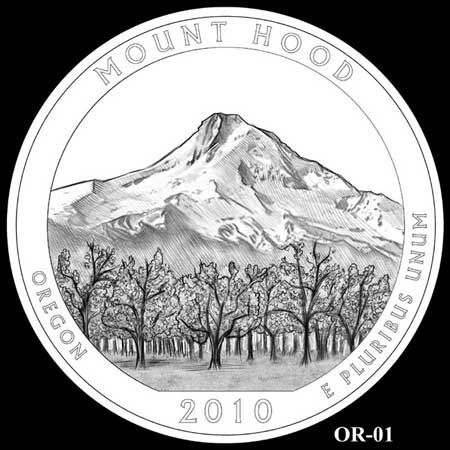
The first design option for the Mount Hood quarter features the picturesque view of mountain from the fruit orchards of the upper Hood River Valley. Though it would make a fine choice, this was not the design forwarded by the advisory committees.

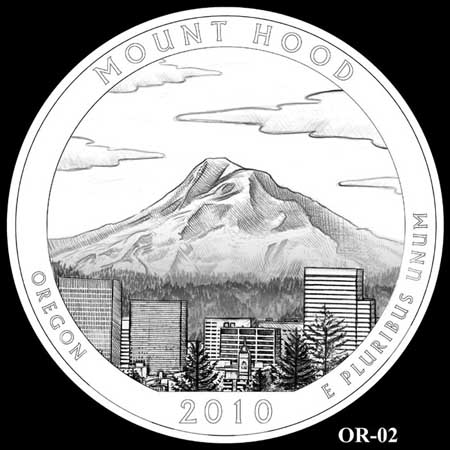
The second option is somewhat awkward, since it places the Portland skyline somewhere in the vicinity of Hood River. Thankfully, this option passed over by both advisory committees, and is unlikely to be selected. It’s somewhat baffling how such an iconic view could be botched like this, and we can only hope that the error would have been caught had the design been selected!
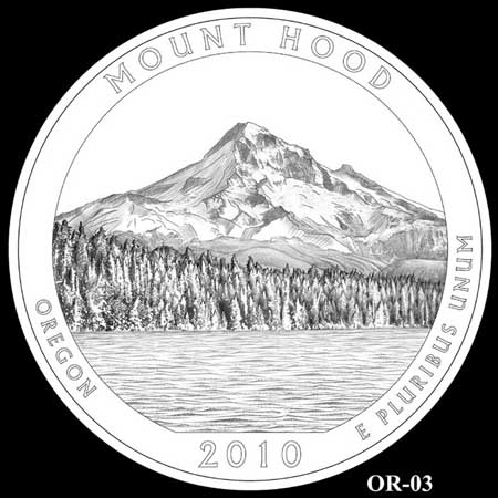
The third option is the familiar and classic view of the mountain from Lost Lake, as seen in a century of countless postcards and other tourist collectables over the decades. This design is the recommended choice of both advisory committees, and seems likely to be the final design.

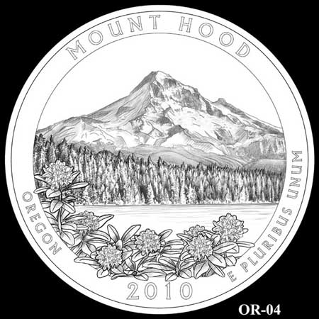
The fourth option is a variation of the (so far) favored Lost Lake option, adding clusters of Pacific rhododendron blossoms to the foreground. This would have been my pick for the coin, but was passed over by the advisory committees as “too cluttered”.

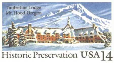
Surprisingly, there were no Mount Hood quarter finalists featuring Timberline Lodge and the familiar south side of the mountain, arguably the best-known view of the mountain. This might be explained by the U.S. Postal Service issuance of a commemorative postcard in 1987 (below) that featured the lodge on its fiftieth anniversary.

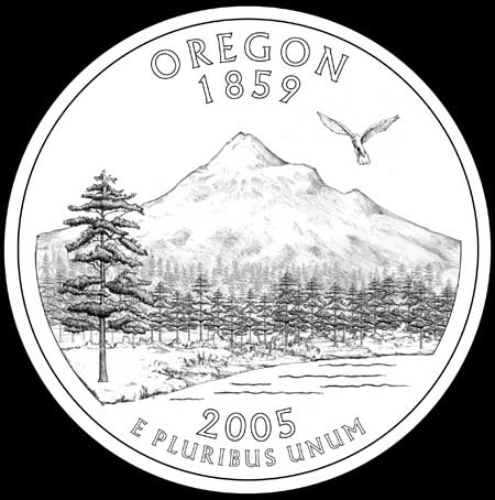
All of this comes on the heels of what was a spirited discussion in 2004, when Mount Hood was one of four designs under consideration for the State Quarters series. This anatomically challenged, clumsy rendering of the mountain was released for public comment on the designs options (along with three other alternatives that featured an Oregon Trail theme, native salmon and Crater Lake):

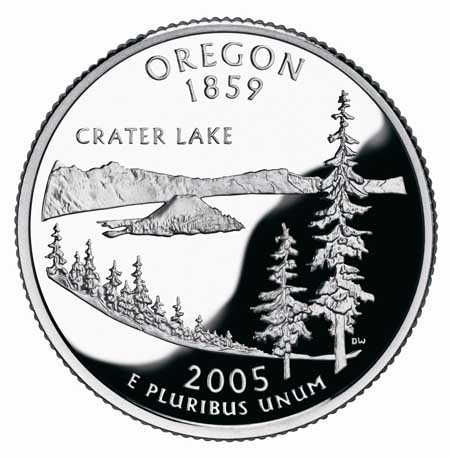
Despite the less-than-inspiring design of the Mount Hood coin in this earlier competition, there was a last-minute flurry of interest in combining the Oregon Trail and Mount Hood themes. After much debate, Governor Ted Kulongoski eventually picked the Crater Lake design (below), and this has now become a favorite among coin collectors.

This earlier choice probably helped move the Mount Hood coin to the front of the line for the America the Beautiful series, though it wasn’t necessarly a given. California, for example, will feature Yosemite on its America the Beautiful quarter, despite having featured the park (and John Muir) on its state quarter. Likewise, Arizona will portray the Grand Canyon on the new quarter, but also featured it on the state quarter series.

So, we’re fortunate that Mount Hood is now getting its due, and will be profiled in such fine company, with more than fifty national parks, monuments and historic sites. It’s an honor well-deserved, and perhaps a foreshadowing of the company that Mount Hood will share in the future.

Addendum

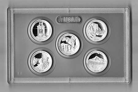
For Mount Hood memorabilia collectors, the 2010 America the Beautiful proof set is here! The following are a couple of scans of the set I received this week. With the set, you will receive the Mount Hood quarter, along with the other four inaugural year quarter — Grand Canyon, Yellowstone, Yosemite and Hot Springs — in this sealed enclosure:
The set comes in this collectable box, with an enclosed certificate of authenticity:

You can order the set direct from the United States Mint.

Proposal: South Fork Water Works Trail

Lower falls on the South Fork Clackamas River in 1963

In 1913, the young cities of Oregon City and West Linn suffered a serious outbreak of typhoid from an increasingly polluted Willamette River, their sole source of water at the time. The incident spurred Oregon City’s leaders to appoint a “Pure Mountain Water League” and directed it to locate a safer source of drinking water.

The League settled on the pristine South Fork of the Clackamas River in the Cascade foothills. The City of West Linn signed on with Oregon City, offering to pay for one third of the cost of a new pipeline to bring the South Fork water to the two cities. A South Fork Water Board was created to carry out this ambitious project.

By the fall of 1915, the new water district had managed to lay twenty-six miles of 18” pipe from a site at the confluence of Memaloose Creek and the South Fork Clackamas all the way to Oregon City and West Linn. The new pipeline began to carry municipal water on October 7, 1915.

Main falls on the South Fork Clackamas River in 1963

In 1939 the South Fork Water Board expanded the system with the help of one of Franklin Roosevelt’s New Deal recovery programs, the Works Project Administration. This project extended a 24” pipeline upstream from the Memaloose Creek intake to a point upstream, above the 120-foot main falls on the South Fork. This project involved carving a series of three dramatic tunnels and a cantilevered pipeline through solid basalt cliffs.

The new intake improved water pressure downstream, and this system continued to serve as the water supply for the two cities until a new filtration plant was constructed on the lower Clackamas River, in 1958. Both systems were used until 1985, when the South Fork pipeline was decommissioned. Since then, the network of roads, tunnels, plank walkways, log bridges and old pipeline has slowly been fading into the green rainforest of the South Fork canyon.

The story might have ended there, except for the series of spectacular series of waterfalls along the South Fork and Memaloose Creek. By the late 1990s, some of the region’s more adventurous kayakers had scouted both streams, and in the early 2000s, had documented the first known descent of the South Fork by kayak.

Main falls on the South Fork with hiker in 1923

These intrepid kayakers portaged the big waterfalls on the South Fork by following the abandoned tunnels and log bridges left behind by the South Fork Water Board. In doing so, they brought renewed interest to the area, as word of a high concentration of waterfalls spread to other adventurers.

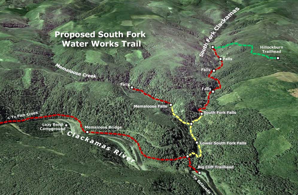
In total, there are five major waterfalls along the final two miles of the South Fork, and two along the last mile of Memaloose Creek, where it flows into the South Fork. The old water works roads and tunnels reach two of the South Fork waterfalls, including the main 120-foot falls, as well as the main falls on Memaloose Creek. The remaining waterfalls are remote, and not reached by the water works roads.

The tunnels and roads along this system are entirely intact and walkable – as several explorers have now documented. A timber bridge over the South Fork at Memaloose Creek is also intact, and is now used by waterfall explorers to cross the stream. These old roads and tunnels offer a unique opportunity for a new trail system that could build on the existing network, and offer an unparalleled blend of natural spectacle, historical artifacts and lots of insight into the history of the South Fork water works project, itself.


(Click here for a larger map)

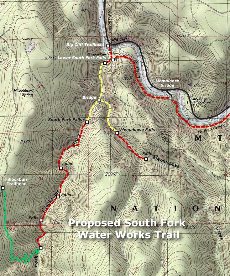
What would this trail look like? The accompanying maps (above and below) show the sections that would follow old water works grades in yellow. All of these roads have been recently scouted, and are in good shape, and thus easily converted to trails. The six tunnels along the way (one along Memaloose Creek and five along the South Fork) are also in good shape, and easily walked, although at two are long enough that a headlamp is required.

New trails would also be needed to complete the system, and are shown in red on the accompanying maps. A new trailhead and access trail would located on the east side of the Memaloose Bridge, following the Clackamas River downstream, then turning up the South Fork canyon and joining the converted water works grade at the lower South Fork falls (this section along the Clackamas would also serve as an extension of the Clackamas River Trail, extending east to Fish Creek, and the current trail terminus).

Two trail extensions would carry hikers deeper into the canyons of the South Fork Clackamas and Memaloose Creek, beyond the water works roads. A new Memaloose trail would climb a half-mile to a second falls, upstream from the main Memaloose falls. An extended South Fork trail would continue from the final waterworks tunnel, and travel 1.5 miles upstream along the west bank of the river, passing three remote waterfalls before ending at the existing Hillockburn Trail (shown in green on the maps).


(Click here for a larger map)

Look closely at the maps, and you will also see a proposal to add a trailhead at Big Cliff, along the Clackamas Highway, with a footbridge connecting across the Clackamas River to the new South Fork trail network. The concept here is to provide a family-oriented day-use area on this scenic bend in the river that serves as the long-term gateway to the South Fork canyon. Today, this spot is an eyesore – a huge dirt and gravel expanse that suffers from dumping, shooting and other unlawful behavior. The trailhead and day-use concept would turn this blank expanse into a place for families to explore the river and nearby trails, less than an hour Portland.

Future trailhead and day-use area at Big Cliff?

In deep, rocky canyons like the lower South Fork, building new trails is complex, costly and at odds with modern conservation ethics, where blasting a trail through cliffs is no longer an accepted practice. Thus, the ability to convert the water works roads would bring hikers into a landscape that probably would never be reached with modern trails. In many ways, the canyon is an accidental version of the venerable Eagle Creek Trail, in the Columbia Gorge, where the route is famously carved into the cliffs.

The logistics for this proposal are also fortuitous. The water works area of the lower South Fork canyon was specifically excluded from the 2009 Lewis & Clark wilderness act that set aside the upstream portions of the South Fork canyon as new wilderness. This means that while the upper canyon trail must be built with wilderness restrictions in mind, converting the roads, repairing bridges and preserving the historical artifacts in the lower canyon won’t be encumbered by wilderness restrictions.

This is a project whose time has come – in part, because the word is out about the scenic wonders of this beautiful canyon, but also because the historic features ought to be preserved before they are lost to time and the elements.

Proposal: Gorton Creek Accessible Trail

GortonCreek01

Emerald Falls on the proposed Gorton Creek Accessible Trail

The Mount Hood National Park Campaign proposes a major expansion of the trail system in the Columbia Gorge and around Mount Hood, including more opportunities for elderly, disabled and young families to experience nature. After all, hiking is the most basic form of active recreation, and should be available to all of us — especially as our region continues to grow and urbanize.

Proposed Gorton Creek Accessible Trail

Accessible trails are designed to provide access for everyone, and these facilities will be in growing demand as our country continues to age. By 2030, nearly a third of our population will be over the age of 55, and accessible trails will be in demand as never before.

In the spirit of providing accessible trails, this proposed new trail at Gorton Creek would allow for easy access to streamside vistas and photogenic Emerald Falls. This section of trail would bring visitors through a lush forest of Douglas fir, bigleaf maple and red alder.

GortonCreek02

Autumn on Gorton Creek as viewed from the proposed location of an accessible viewpoint

Gorton Creek becomes increasingly prominent as the trail draws near the stream and the sound of rushing water fills the air. Just below the proposed viewpoint of Emerald Falls and rushing Gorton Creek, there is a large gravel beach at a bend in the stream that could even provide the potential for universal access to the stream, itself — a first in the region.

The accessible portion of the new trail would largely follow an existing boot path that, in turn, follows a very old roadbed still shown on USGS maps. Thus, the gentle grade that would meet accessible trail design requirements. The dashed yellow line on the map, below, shows where the roadbed segment could be improved to provide universal access to a streamside overlook just below Emerald Falls.

GortonCreek03

Proposed Gorton Creek Family Trail

Family trails are designed to allow young children on foot, in backpacks or in strollers to have their first nature experience, and hopefully begin a lifetime of active recreation in nature.

The second part of the proposed Gorton Creek Trail would be designed for young families, with a short, easy grade leading to a viewing platform below Gorton Creek Falls. The falls is a towering 120 foot plunge set against a magnificent wall of columnar basalt, and would provide an exciting destination for budding young hikers. This section of proposed trail is shown in red on the map, above.

The family trail portion of this project would a couple of important objectives. First, it would provide a new hiking option for families with beginning hikers, with easy access from Portland and the potential to camp at Wyeth Campground as part of the adventure. Such trails are in surprisingly short supply in the Gorge, and therefore often crowded when families are most likely to visit, depriving them of a quality nature experience.

Second, this segment of the trail would combine with the lower, accessible segment to allow for extended family outings — grandparents enjoying the lower streamside viewpoint as young children and parents hike the short family spur to the main falls viewpoint, for example, with the extended family camping or picnicking at the Wyeth Campground.

Gorton Creek Restoration

While this proposal would meet growing needs for accessible trails in the region, it would remedy an escalating problem at Gorton Creek: the secret is out on Gorton Creek Falls, and waterfall enthusiasts are wreaking havoc on the trail-less canyon section above Emerald Falls as they scramble to reach the main falls, upstream. The damage to the canyon slopes (see photos, below) and stream bed is particularly worrisome given the important role the stream has as fish habitat.

GortonCreek04

Gorton Creek Falls is no longer a well-kept secret. Each summer, more visitors are pushing cross-country through the upper canyon, leaving damaged slopes and trampled vegetation in their wake

Finally, trail construction could also allow for the washed-out waterworks at Emerald Falls (see photo, below) to be permanently relocated within the trail corridor, and less prone to the periodic failures that plague the current streamside alignment. The water pipeline is currently in a precarious condition, and would greatly benefit from a trail project happening in this canyon sooner than later.

GortonCreek05

The washed out water supply line for Wyeth Campground hangs from cables anchored to stakes below Emerald Falls

To visit Gorton Creek, drive east of Cascade Locks to the Wyeth exit, turn right, then turn right again on the old highway that parallels I-84. Watch for the Wyeth Campground on the left, just before a bridge over Gorton Creek. If the campground gate is closed, park to the side, and walk through the campground to the well-marked trailhead at the south end — otherwise, you can drive to the trailhead.

To reach Emerald Falls, follow the formal trail 0.1 miles to a junction with Trail No. 400, where it crosses Gorton Creek on an impressive footbridge that kids will want to explore. Continue straight, past the bridge and Trail 400, following the obvious footpath up the east side of the stream canyon for another 0.4 miles. Watch your step around Emerald Falls, as the water works erosion has left abrupt holes and weakened stream banks. Do the canyon a favor, and don’t scramble upstream to Gorton Creek — wait for a trail to be built, instead!

(Editors Note: Trail No. 408 already carries the name “Gorton Creek Trail”, but never comes close to the creek, traversing high above the canyon rim on the shoulder of Nick Eaton Ridge. This trail eventually climbs to the summit of Green Point Mountain — and thus, might be better named the “Green Point Mountain Trail” should a new trail along Gorton Creek become a reality, if not before)

Indian Salmon Harvest

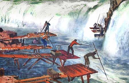
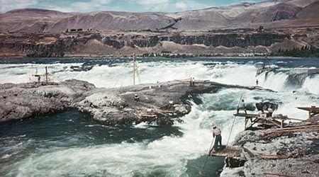
1930s painting of Indians fishing at Celilo Falls, as they had for thousands of years prior to white settlement of the Oregon Country.

1930s painting of Indians fishing at Celilo Falls, as they had for thousands of years prior to white settlement of the Oregon Country.

In recent years, conservationists have lined up against a proposed Indian Casino in the Columbia Gorge, and with good reason. While the project would certainly benefit the people of the Warm Springs tribe, it would also have unacceptable environmental effects on the Gorge (A better solution is to simply locate the casino in Portland, which is the obvious force driving the Cascade Locks location – separate article to follow).

But if you are a like-minded conservationist, you have an alternative for supporting the Native American economy that doesn’t involve slot machines. Simply pack a large cooler on your next visit to the Gorge, and stop by one of several roadside salmon markets, where Indians from the Gorge tribes sell fresh, “over the bank” chinook, coho, steelhead, sockeye, walleye and shad.

1930s rendering of Indian fisherman working the narrows below Celilo Falls

1930s rendering of Indian fisherman working the narrows below Celilo Falls

A surprisingly small number of urbanites who visit the Gorge support these fishermen, possibly because they don’t understand the fishery. But if you have never had fresh salmon, you will be pleasantly surprised at the difference in flavor between the tribal fisheries and the fish-farm salmon that your local supermarket is likely selling as “fresh” (dyed pink to disguise its origin, since fish farms produce a gray meat in salmon).

The tribes also sell the finest smoked salmon available, anywhere — after all, they have had thousands of years to perfect the smoking process, and smoked salmon can be eaten plain, as a snack or with hors d’oeuvres, or used in salads, pasta, casseroles or other cooked dishes. Fresh and smoked salmon freezes well, so buying during the fall harvest, in particular, can provide for a full winter of salmon in your diet. This is an excellent option when fish isn’t available at the roadside markets, and helps the tribes sustain their economy over the winter months, as well.

The Nez Perce, Umatilla, Warm Springs and Yakama tribes have had permanent rights to harvest salmon from the Columbia River under a series of 1854-55 treaties with the United States Government. While these treaties have been subject to much litigation — and questionable “compensation” agreements allowed for destruction of Celilo Falls in the 1950s — the tribes manage the fisheries today in cooperation with the state governments of Oregon and Washington through the Columbia River Inter-tribal Fisheries Commission. The focus of the Fisheries Commission is on habitat recovery and sustainable fishing practices, and ensuring that this ancient tradition isn’t lost.

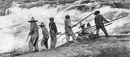
Indians fishing Celilo Falls with dip nets in the early 1900s, prior to construction of dams at Bonneville and The Dalles.

Indians fishing Celilo Falls with dip nets in the early 1900s, prior to construction of dams at Bonneville and The Dalles.

On a recent stop at the Cascade Locks market, beneath Bridge of the Gods, a young Indian in his teens asked me “if I knew any stories about Lewis & Clark”. I looked down at my faded t-shirt, commemorating the Lewis & Clark expedition, realizing why he had asked the question.

I responded with a few anecdotes from the expedition — how the Indians at Celilo had introduced the explorers to salmon, and in doing so, probably saved their lives. I also mentioned that the early white explorers unknowingly brought diseases with them that erased much of the native population, even before the huge waves of white settlers followed in the 1840s. To his apparent surprise, I also talked about the Corps of Discovery being the first true democracy in the United States, with an Indian woman (Sacajawea) and a black man (York) given equal voice at major turning points in the mission.

Upon that, he reached out, shook my hand, and said “thanks, man. I love to hear those stories.” But we both knew he was really testing my knowledge — and my respect for his native culture — to see if I was just another ignorant tourist in a Lewis & Clark t-shirt. I walked away with a bag of smoked salmon fillets and thinking what a complicated world it still is for young Native Americans.

You can learn more about the Indian Fishing Harvest at this official website, including the history of Indian fishing in the Columbia, where to find roadside stands, and how to buy fish from roadside vendors. Often, there are several vendors at a site, so if you plan to buy a few packages of fish, make your way from stand to stand, so that you support each of the vendors.

Restoring forests, one community at a time

Interior Secretary Ken Salazar set the Pacific Northwest forest recovery effort back on track in July when he reversed the Bureau of Land Management’s (BLM) Western Oregon Plan Revisions (the WOPR, a brilliantly unintentional blunder as acronyms go, as it became known as “The Whopper”). This represented a major step back from scientifically corrupt policies intended to enrich timber corporations at great cost to our public lands.

In this recent opinion piece in The Oregonian, Dominick DellaSala and Randi Spivak respond to Salazar’s move, and provide an excellent framework for how we should move forward to restore our public forests. Their prescription: emphasize needed thinning of the sickly, biologically sterile tree plantations left from the logging heyday of past decades, and embrace the value that our restored forests will have in the global effort to reduce carbon emissions.

The eastside forests spreading out below Lookout Mountain look healthy enough from a distance, but in reality are in dire need of a bold new restoration strategy.

The eastside forests spreading out below Lookout Mountain look healthy enough from a distance, but in reality are in dire need of a bold new restoration strategy.

As described in their article, the Siuslaw National Forest has already begun to embrace this new approach, and other public forest managers are beginning to take notice. But a truly comprehensive restoration effort must be more aggressive, and should also focus on stabilizing the forest-based communities that were left to die when the big timber operations pulled out in the 1980s and 90s

Traditional thinning offers a couple of opportunities for local communities: the timber operations involve most of the same logging skills that were once the mainstay of rural Oregon. In addition, the harvested wood from thinning offers not only traditional saw logs for small mills, but also a new economic niche in the smaller woody debris that was once discarded or burned on site in the forests. New uses for small woody debris include engineered wood products and even energy production as biomass.

A closer view of typical second-growth forests near Lookout Mountain reveals a dying, overcrowded ecosystem under great biological stress.

A closer view of typical second-growth forests near Lookout Mountain reveals a dying, overcrowded ecosystem under great biological stress.

One practical challenge in reaching this new approach will be the scaled-back network of logging roads, since the over-built system constructed in the second half of the 1900s is rapidly crumbling and infeasible to maintain for the long term. One strategy is to tie road decommissioning to forest thinning and restoration efforts, pulling out obsolete roads after forests have been largely restored. Another could be aerial operations, perhaps even balloon logging. Still another could be roadless logging with light equipment or even horses — a practice well established on small, private woodlots in Oregon.

The key to finding this new balance in sustainable forest restoration a role of direct stewardship among the forest communities — to view them as the keepers of the forest, as opposed to the “forest dependent” mindset of the industrial logging era. This means establishing an ongoing relationship between community-based forest management organizations and the federal agencies that govern most of our public forest land. These new organizations could follow the lead of watershed councils and farm bureaus, using formal governance coupled with direct management responsibilities as forest recovery agents.

A bright spot in the restoration of the eastside forests near lookout mountain, this thinned plantation is beginning to resemble a natural forest, with multi-aged stands and a recovering understory.

A bright spot in the restoration of the eastside forests near lookout mountain, this thinned plantation is beginning to resemble a natural forest, with multi-aged stands and a recovering understory.

How would the economics of community-based stewardship work? In a commodity-based model of selling products recovered from thinning, the objective is straightforward — but unlikely to be profitable as a private enterprise.

Instead, the public will likely need to provide some level of subsidy for the restoration work involved, with commodity proceeds offsetting public costs. The advantage of a public subsidy is that it provides an ongoing public interest in the health and viability of the forest communities, themselves, and could help avoid the volatility that private timber harvesting brought to these communities in their first century.

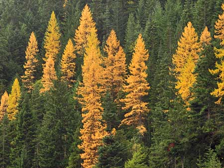
A few stands of late succession ponderosa and Western larch forest still exist on the slopes of Lookout Mountain, providing a glimpse of what a restoration policy must aim for.

A few stands of late succession ponderosa and Western larch forest still exist on the slopes of Lookout Mountain, providing a glimpse of what a restoration policy must aim for.

But the more interesting idea is to create a long-term financial model for stewardship communities based on carbon sequestration as part of global efforts to reduce carbon emissions. Carbon credits would be sold as offsets to carbon polluters, and providing a permanent incentive to bring the northwest forests back to health.

The credits could be managed as a community trust, or managed through a public-private corporation. Under this paradigm, there would be little incentive to harvest large trees, since they would exist primarily as carbon storage units under the new carbon-based economic framework.

Of course, we also know that big trees and mature forests also provide a much wider array of ecological and social benefits, but these costs have never factored in to the short-term price for raw logs in the old timber harvesting paradigm. As DellaSala and Spivak point out in their article, the Pacific Northwest is uniquely capable of storing carbon in our living forests, and to a degree nearly unmatched in the world. If this potential is given a value, then we may well seen an end to the destruction of our mature forests for saw logs and pulp that could just as easily be manufactured from private plantation materials.

The concept of community-based stewardship in carrying out forest restoration is attainable, as evidenced by the many successful public-private partnerships that exist today. But it’s unclear if the Forest Service and BLM bureaucracies are flexible or willing enough to embrace the idea.

Instead, a new conservation-based form of administration may be needed — broader than the National Park Service in scope, but borrowing from the Park Service ethic of conservation and sustainability. The Cascade Forest Preserve, perhaps, extending from the Sierras to the Canadian border? Given the grave implications of climate change, it is impossible to think too big or boldly as we search for a way forward.

The Mount Hood Lily

MountHoodLily01

Second only to our towering Pacific rhododendron (Rhododendron macrophylum) in pure spectacle, the striking white trumpets of the Mount Hood lily are unforgettable. These handsome lilies often grow to more than six feet in height with as many as 20 flowers, each up to 8 inches in length. Never heard of the Mount Hood lily? That’s probably because you know this as the Washington lily (Lilium washingtonianum Kellogg), though it is also widely known as the Cascade lily and Mount Hood lily. A slightly variant race of the species in Northern California is commonly called the Shasta lily.

But the rather generic name of “Washington lily” is made more confusing by the simple fact that this beautiful plant doesn’t even grow in the state of Washington. Its northern extent is the area around Mount Hood, and its range extends down the Cascades and into the California Sierras. But thankfully, it turns out that the lily wasn’t named for the State of Washington, at all. Instead, the naming pre-dates Washington statehood.

In fact, botanist Albert Kellogg named this regal flower for Martha Washington, wife of our first president, when he first described the species in 1859. The spectacular, aromatic plants were soon collected for gardens and picked by forest visitors, locally decimating the population by the 1950s. Today, they have made a comeback, and are relatively common across their range, especially around Mount Hood.

Martha Washington and a Nineteenth Century rendering of our western lily named in her honor

Martha Washington and a Nineteenth Century rendering of our western lily named in her honor

Like most lilies, the Mount Hood Lily is a perennial that grows from a bulb, and thus the ease in collecting the species for commercial use. Native Americans also collected the bulbs as a food source. The plant grows in open woodlands and forest openings, often in surprisingly dry conditions.

In addition to multiplying their bulbs over time, the plants produce up to 200 seeds in the capsules that follow each flower. While digging the bulbs is strongly discouraged, collecting the seeds to grow in home gardens is a responsible, sustainable means of propagating the plants. Collected seeds of the native species, as well as many hybrids, are also available from specialized retailers.

So, in the spirit of provincialism, I propose that we rename this plant, simply because of the confusion over the name — after all, Kellogg named the plant in the year in which Oregon became a state, so he was likely unaware that another state in the Northwest would be named for George Washington.

There’s also the fact our first First Lady already has the aristocratic series of Martha Washington Geraniums (Pelargonium domesticum) named in her honor, and thus adding the Mount Hood lily is a mere asterisk in comparative prominence. Besides, Martha Washington has already had three postage stamps, two early dollar bills, several U.S. Mint commemorative coins and the only U.S. naval ship — the U.S.S. Lady Washington — to be named for a first lady.

As a modest and proper woman in the tradition of her time, surely she would cringe at this embarrassment of honors? And as the chief overseer of the Mount Vernon plantation and a gardener herself, surely Martha Washington would be the first to agree that the Mount Hood lily is a far superior name, both in descriptiveness and clarity?

This leads us to another simple compromise: when she tended to troops at General Washington’s side in the desperate struggle at Valley Forge, Martha Washington became known as Lady Washington, and a true heroine in her time. So, perhaps the Lady Washington lily would be a proper solution to our naming dilemma?

Between a rock and a hard place…

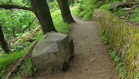
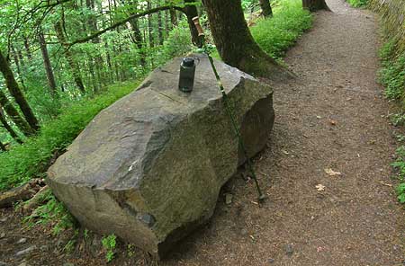
Sometime in the past couple of years, a refrigerator-sized piece of basalt split from the cliffs above Horsetail Falls, tumbled across two switchbacks on Gorge Trail 400, and landed perfectly on a third, forming a handy bench that only Mother Nature could design – or did she?

The convenient boulder that recently appeared on Trail 400, above Horsetail Falls - the work of man or nature?

The convenient boulder that recently appeared on Trail 400, above Horsetail Falls - the work of man or nature?

Rocks like this are constantly breaking loose from the walls of the gorge, usually far from the view or earshot of hikers. Through the relentless effects of water, and cycles of freeze and thaw during the winter months, bits and pieces of the stacked layers of basalt eventually break free, and join the enormous piles of talus that have accumulated beneath the cliffs over the millennia.

The new bench-boulder above Horsetail Falls is a bit chunkier than most, but tiny when compared to the house-sized boulders that are known to break loose on occasion. One infamous event near Wahclella Falls in the late 1960s was massive enough to send an entire subdivision of house-sized boulders into Tanner Creek, temporarily forming a small lake in the aftermath.

Looking down at the new boulder, the view is a bit more menacing, with a big bite taken out of the solid rock wall in the foreground, and a trail of debris, below.

Looking down at the new boulder, the view is a bit more menacing, with a big bite taken out of the solid rock wall in the foreground, and a trail of debris, below.

Assuming that the big rock did land in the middle of the trail, there are a couple of miracles that suggest divine placement. First, the boulder missed the adjacent wall, though it took a sizeable bite out of a retaining wall further uphill (see photo, above). Second, the boulder managed to land parallel to the path, and just far enough from the rock wall to allow hikers to easily slip between… a rock and a hard place!

It’s possible that trail crews could have jimmied this massive stone into its convenient position, but unlikely. Just one cubic foot of solid basalt weighs in at a staggering 188 lbs, which means that this fridge-sized weighs at least 12,000 pounds — more than six tons!

Perfect for a trailside respite, the big rock bench is already a favorite of hikers

Perfect for a trailside respite, the big rock bench is already a favorite of hikers

A more unnerving thought is the possibility of hikers actually witnessing nature at work, here, given the popularity of this well-traveled path nearly year-round. But, even with the scores of hikers walking by, there are plenty of quiet spells during the winter season, when this stone most likely made its move — and there’s also the dark of night.

However the big rock arrived, it has already become a popular stopping point for newbie hikers, puffing their way up the trail from Horsetail Falls, in search of Ponytail Falls. In this way, the big rock might just be Mother Nature’s way of tempting her most impatient species to stop and relax, if only for a moment.

Tunnel Point Wayside

The sprawling vista into the Gorge from Tunnel Point Wayside

The sprawling vista into the Gorge from Tunnel Point Wayside

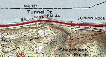
Mostly lost in the noise of Interstate-84, the tiny Tunnel Point Wayside is a forgotten bit of ground that deserves a little more respect. This spot is named for the railroad tunnel that cuts through the lower buttress of Chanticleer Point, to the south. In the early days of Highway 30 construction in the Gorge, the wayside at Tunnel Point was designed as a scenic turnout for visitors. From here, the first big view of the Gorge spreads out, with Crown Point and Vista House framing the scene.

TunnelPointMap

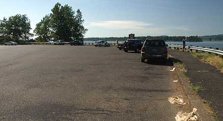
Today, freeway barricades prohibit access to the wayside for eastbound travelers entering the Gorge, and the turnout is an afterthought for most westbound travelers, since the Gorge view is behind them. The wayside has thus devolved into a huge, paved layover spot for semi-trucks — a sad epitaph for what should (and could) be a premier gateway viewpoint in the Gorge.

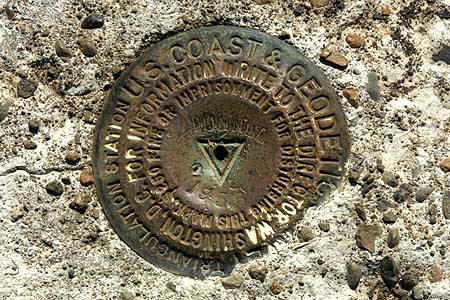
Tunnel Point has two U.S.G.S. benchmarks and a ship beacon bolted to its tiny, rocky cape. Beyond the sterile steel guardrail that borders the turnout, basalt cliffs drop 20 feet into the river. These little cliffs are likely remnants of a more noble formation, undoubtedly quarried to help build the modern highway in the Gorge in the 1940s and 50s. But they still give a sense of the natural environment that once existed here, and provide for an interesting shoreline along the river.

This USGS benchmark was placed in 1956, likely in conjunction with modern highway construction in the Gorge.

This USGS benchmark was placed in 1956, likely in conjunction with modern highway construction in the Gorge.

Look closely at these rocky mini-bluffs and you’ll see cliff-dwelling Gorge plants making a home, while red alder and Douglas fir are colonizing the rocky shoreline on both sides of Tunnel Point. Nature is making a valiant attempt to restore this spot, even if we humans are lagging in the effort.

How could the Tunnel Point Wayside be restored? For starters, the massive expanse of asphalt could be redesigned to restore green areas, with landscaping, trees, picnic tables, restrooms and perhaps a travel information center. After all, this spot is as much a gateway to the Portland metropolitan area as to the Gorge, given that access is limited to westbound travelers.

Next, a series of walking paths could be added along the little bluffs, providing a place for travelers to stretch their legs, and learn a bit about the Gorge. A wooden Oregon History sign is already mounted in the parking area, and could be restored to become part of an improved interpretive display and walking path system.

Wasted space: the vast, barren turnout at Tunnel Point.

Wasted space: the vast, barren turnout at Tunnel Point.

These improvements would provide for a welcome refuge for travelers arriving in the Portland region from points east, but what about travelers entering the Gorge from the west? Providing access to eastbound visitors would be a tall order, requiring some sort of overpass or tunnel to deliver visitors from the opposite side of the highway. The cost, logistics and visual impacts probably make this infeasible, unfortunately.

But for now, improving the wayside for westbound traffic would be a big step in the right direction. Since the wayside is within the highway right-of-way, improvements could be built by the Oregon Department of Transportation (ODOT) with highway funds, in conjunction with Oregon Parks and Recreation. Tunnel Point Wayside deserves this new lease on life, and travelers in the Gorge deserve to enjoy this unique perspective of the river and Gorge.

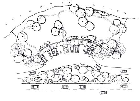
Postscript: after writing this article a few months ago, I ran across a “generic” roadside pullout design in the 2005 I-84 Design Strategy — a joint ODOT, U.S. Forest Service, Federal Highway Administration and Columbia Gorge Commission planning document that lays out the framework for future improvements to the highway within the Columbia River Gorge National Scenic Area.

The schematic looks tailor-made for the Tunnel Point Wayside, and in this design, reclaims much of the parking area as a park with riverside loop trail. Though hard to see in this scaled-down version, the plan calls for just ten parking spots, with trucks obviously barred from entering (the truck stops in Troutdale are only a few miles further, after all). Most interesting are bio-swales on both sides of the pullout, draining the parking area and adding more green screening from the highway. A glimpse of what might be, perhaps?

Restoring Celilo Falls

Celilo Falls has always been phantom of history to me, since I born a few years after the U.S. Army Corps of Engineers buried the falls behind The Dalles Dam in 1957. My understanding of the falls and the loss it now represents has come from old photos and maps, and a few shaky film images.

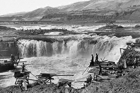
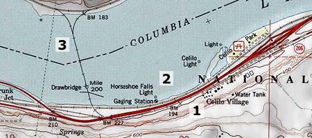
The railroad bridge in the background of this iconic view is the key to locating the falls today

The railroad bridge in the background of this iconic view is the key to locating the falls today

Yet for many, the falls and the native culture surrounding them are alive and vibrant in their memories, thanks to seeing and experiencing them first-hand. For Native Americans, the vivid memories only add to the pain of losing a place that quite literally defined a people for millennia.

The idea of restoring the falls — even temporarily — has been suggested over the years, usually to be slapped down quickly by the Corps of Engineers as unfeasible, or even dangerous. In the late 1980s, a brief, 30th anniversary movement to temporarily draw down the pool behind the dam briefly gained local momentum before the federal agencies killed any talk of the idea. The Corps likely realized that revealing the falls to the public even once could make it politically impossible to ever refill the dam again.

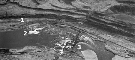
This 1940s aerial view shows the falls and railroad bridge, looking south

This 1940s aerial view shows the falls and railroad bridge, looking south

The hostility of the federal agencies toward even acknowledging the falls fanned the rumors among the local tribes that the falls had, in fact, been purposely destroyed by the Corps of Engineers just before they were inundated. This rumor persisted until last year, when a new mindset among Corps managers spurred the agency to compile a comprehensive sonar map of the falls to show that they are quite intact, beneath the still surface of the reservoir.

The sonar confirmation of the intact falls has breathed new life into the hopes of many that the falls will not just someday be restored, but perhaps someday soon. This is where the restoration of Celilo Falls fits within the scope of the MHNP Campaign: the emerging environmental theme in the coming century is restoration, and no place in the Pacific Northwest is more deserving — perhaps even the nation, considering that 11,000 years of Native American culture at Celilo makes it the oldest continuously settled place in North America.

This map clip correlates today's landmarks to the aerial view of the falls, above

This map clip correlates today's landmarks to the aerial view of the falls, above

But the connection to Mount Hood is even more elemental: the mountain towers over the Celilo country like a beacon, and has been a similarly important feature in the culture of Lower Columbia tribes. Celilo and WyEast are connected, and so their restoration should be. A joined effort to heal these places expands the possibilities for both.

What will a restored Celilo Falls look like? Initially, it will likely be mineral-stained and muddy. But the new sonar maps confirm that silts have not overtaken the falls, so if the pool behind The Dalles Dam were simply lowered today, we would see a largely intact falls — perhaps even with traces of the cantilevered dip net fishing structures that once clung to the rocks around the falls. And over time, the falls would quickly recover to blend again with the surrounding landscape.

R. Swain Gifford's 1875 etching of Mount Hood towering over the Celilo Narrows is among the earliest geographically accurate renderings of the area

R. Swain Gifford's 1875 etching of Mount Hood towering over the Celilo Narrows is among the earliest geographically accurate renderings of the area

What would a restored Celilo Falls mean for the mid-Columbia economy? The immediate impact would be on power supplies, and it is unlikely that the falls could ever be restored without some alternate energy supply — perhaps a wind farm of equal wattage? — ensuring that no net loss in energy production would result.

The next big question would be impacts on shipping, but the good news here is that barges were already using the Celilo Canal to bypass the falls long before the dam was erected. The canal system would conceivably resume this function, if the falls were reborn, albeit with likely improvements and modernization.

These scene was photographed in the mid-1950s, just before the falls was inundated

These scene was photographed in the mid-1950s, just before the falls was inundated

What kind of protection should the restored Celilo Falls receive? That part is easy. The astonishing scope of history tied to the falls easily qualify the site for World Heritage status within the U.S. National Park System, perhaps as a National Historic Site. This would put the restored falls in a category with places like Mesa Verde, in Colorado, and provide the needed framework to preserve and understand the historic resources that lie beneath today’s reservoir.

Restoration of Celilo Falls is a long-term dream of so many, but movement in that direction really began as soon as the falls disappeared in 1957. The falls has never left our collective consciousness, and thus demands restoration.

Another small step toward restoration will occur in 2009, when the commemorative Confluence Project will bring an art installation to Celilo. The project is marking the two centuries since Lewis and Clark passed through the region, and the millennia of human history that makes Celilo unique. A small step, but also a bit more progress toward what I believe will be the inevitable restoration of Celilo Falls — under the gaze of a restored Mount Hood.

Fire Forests of the Cascades

The Gnarl Fire of 2008 shocked Portlanders by racing across the east slopes of Mount Hood, and nearly destroying the historic buildings at Cloud Cap and Tilly Jane. But as an east side fire, the Gnarl burn was relatively small, and part of what has become an annual ritual for rural communities of fighting intense blazes along the east slope of the Cascades.

The 2008 Gnarl Fire, viewed in August from Dufur Mill Road

The 2008 Gnarl Fire, viewed in August from Dufur Mill Road

The cause for the intensity of these fires is well-known and well-documented. We know that a century of fire suppression, promotion of even-aged stands of second growth in logged areas and a changing climate are forces conspiring to burn the east side forests on a scale not seen in recent decades.

But not all of the east side fires are catastrophic, even with the fuel build-up from our history of fire suppression. The 2006 fire at Bluegrass Ridge was a glimpse into what was once a routine occurrence along the east side of the Cascades. The Bluegrass Fire began as a lightning strike in the dry season, and soon spread along the east face of the ridge in a mosaic pattern: some parts of the forest were completely killed, while others were a mix, where pockets of forest survived among the burned trees.

The aftermath of the 2006 Bluegrass Fire ranged from total destruction in areas like this, to mosaic patterns where less crowded forests existed

The aftermath of the 2006 Bluegrass Fire ranged from total destruction in areas like this, to mosaic patterns where less crowded forests existed

Most significantly, the larger, fire-resistant species like western larch and ponderosa pine often survive fires in these mosaic areas, and this was the case in the Bluegrass Fire. We will know in a year or two whether the extensive larch population in the Gnarl Fire area were similarly resistant.

The survival of these big trees is the key to the natural ecosystem that defines east side forests. Forest ecologists are now calling these east side regimes “fire forests”, as a counterpoint to the west side rain forests, where abundant rainfall is the operative element in defining the forests.

The “fire forest” name is apt, since we now know that a number of tree species in this dry forest system depend on fire for natural succession that creates mature forests. In the Mount Hood area, these east side trees are Douglas fir, western larch and ponderosa pine. All three have thick, fire-resistant bark that helps them survive moderate fires, and benefit from periodic clearing of undergrowth that competes for moisture and soil nutrients. Fires, in turn, release nutrients for the big trees, further enhancing the growth of fire-resistant species.

Western larch light up the eastside forests in autumn. Larch are among the fire-resistant species that require periodic burns for their long-term health

Western larch light up the eastside forests in autumn. Larch are among the fire-resistant species that require periodic burns for their long-term health

The question for the east side forest is not whether they will continue to burn — they have evolved with fire, after all — but rather, how we will learn to live with the fires. We now know that we cannot simply extinguish them. A century of fire suppression has created mammoth fires that we simply cannot control.

We also know that we cannot prevent forest fires from starting, since the large majority begin from lighting strikes. And we know that many more catastrophic burns will occur before the east side forests return to a more sustainable condition that mimics the natural ecosystem that once thrived.

Most ominous is the recent discovery — from tree-ring research — that the Western states are coming off an unusually wet century, and that the decades ahead are likely to carry more drought, not less. So it is imperative to help the east side forests stabilize before conditions make that proposition still more difficult.

These mature, healthy forests of western larch, ponderosa pine and Douglas fir along Bluegrass Ridge survived the fire

These mature, healthy forests of western larch, ponderosa pine and Douglas fir along Bluegrass Ridge survived the fire

A first step is continuing to thin tree plantations on logged lands to help prevent still more crowded, bug-infested forests like those that are currently driving the fire epidemic. The second step is more difficult: letting fires burn. This policy will be most difficult in the many areas where rural development has encroached on forest boundaries, but it is a necessary step. Both of these steps will require a new mindset about fire, not the least of which will be a public education shift away from Smokey Bear and fire suppression and toward a modern understanding of fire.

But a third step is most difficult of all: setting fires in prescribed locations to help restore forest balance. While the rash of east side fires in recent years has made this part of restoring forest balance less urgent, it will still be necessary — and controversial. Federal agencies have already begun employing this tool, but in cases where a controlled burn becomes a wildfire, the public is not prepared to understand why that risk is necessary — and perfectly natural. Still more public outreach and education will be needed.

The good news is that the scientists are winning this debate, and even the Forest Service has gradually begun to embrace fire ecology as part of their management philosophy. The Park Service is much further long, having successfully weathered the early criticism of their prescient decision to let the huge Yellowstone fires of the mid-1980s burn.

The remarkable resilience and recovery of Yellowstone in the intervening years has not only been vindication for that bold decision, but also an invaluable lesson to land agencies across the west who are responsible for managing “fire forests”. The time to embrace fires in our forests has arrived.

Phoca Rock

An early 1900s postcard shows a steam ship passing Phoca Rock

An early 1900s postcard shows a steam ship passing Phoca Rock

Anyone who has made a few trips through the Columbia Gorge has noticed the small monolith that pokes out of the center of the river near Cape Horn. This is Phoca Rock, and its distinction lies partly in the fact that it is one of the few landmarks in the Gorge that carries the name given by Lewis and Clark on their 1805-06 Corps of Discovery journey.

Lewis and Clark didn’t actually name the rock until they were camped on the Oregon Coast, and compiled their journals while suffering through a dank Northwest winter. William Clark named the rock for the abundant harbor seals spotted in the river – phoca vitulina.

Harbor seals basking in Alaska's Tracy Arm

Harbor seals basking in Alaska's Tracy Arm

Harbor seals are still native to the lower Columbia River, although in smaller numbers than when Lewis and Clark paddled through. Government bounties in Oregon and Washington killed more than 20,000 Harbor seals in the two states from the 1920s through 1972, when hunting was finally banned.

The Harbor seal population has since rebounded from fewer than 7,000 seals at the time of the ban to more than 17,000 today. Still, biologists in both states must monitor the seals for health and impacts from commercial fisheries.

Phoca Rock continues to serve as a river beacon today, marking the edge of shipping lanes on the Columbia. The rock marks the edge of two-foot shallows along Oregon’s Sand Island and the 45-foot deep Candiana Channel that separates Phoca Rock from Cape Horn, on the Washington side.

Phoca Rock today, as seen from Bridal Veil State Park

Phoca Rock today, as seen from Bridal Veil State Park

Clark estimated the rock to be 100 feet tall, but today we know it to be just 30 feet. Its prominence lies in its isolation, and early names for the rock underscored this point: beginning in the mid-1800s, Phoca was alternately called “Hermit’s Islet”, “Lone Rock” and “Sentinel Rock” before the federal government finally restored the original name given by Lewis and Clark, in the early 1900s.

This 1911 map shows Phoca Rock with its restored name

This 1911 map shows Phoca Rock with its restored name

So, why is Phoca Rock sitting alone, in the middle of the Columbia River? Chances are the rock isn’t a tiny cousin to nearby Beacon Rock, the exposed, solid core of an ancient volcano. Phoca is more likely an outcrop of the Grande Ronde basalt flows that produced the cliffs of Cape Horn, to the north, and the Pillars of Hercules, along the Oregon shore.

One of many old postcard views that show "Sentinel Rock", one of the itinerant names for Phoca Rock

Diminutive Phoca Rock is as tough as it is tiny. The rock survived multiple Missoula Floods, after all, and thousands of years of parting the waters of the Columbia River. And left alone, Phoca Rock will continue to weather the elements for millennia with little change, long after the ribbons of asphalt and steel that line the Gorge have vanished.