Unfinished work at Tumala

Most of us grew up using the word “squaw” as the counterpoint to “brave” in our one-dimensional, Hollywood version of Indian culture. But historians and Native Americans always knew this word to be derogatory and offensive in its original use, so the current national efforts to remove “squaw” from maps and places is long overdue.

In Oregon, the list of places using this name numbers 172, but nowhere was there such a concentration as in the Roaring River high country, where no less than four features — plus a road — were named “squaw”.

Acting on a legislative directive, the Clackamas County Commission began the work of changing the names of “Squaw” mountain, meadows, lakes and creek to “Tumala” in 2007, and the Oregon Geographic Names Board completed the work in early 2008. Tumala is a Chinook word meaning tomorrow, or afterlife, and is as good a name as you might wish for in this lovely mountain blend of craggy peaks, big trees and sunny meadows.

Beautiful Tumala Lakes and Meadows in the Roaring River backcountry

Beautiful Tumala Lakes and Meadows in the Roaring River backcountry

But the work here has only begun. Tumala Mountain and the surrounding country are rich with Native American and early pioneer history, yet little has been done to simply preserve the legacy, much less celebrate it.

Native Americans hunted and foraged along the high ridges of Tumala Mountain area for centuries, and likely set fires to keep the huckleberry slopes productive.

In the autumn of 1855, a 22-year old U.S. Army lieutenant named Henry Abbot and his 18-year old Indian guide, Sam-ax-shat, led a survey party across the Cascades. They followed the high divide between the Salmon and Roaring rivers, and passed through the Tumala Lakes basin, a protected refuge with water and grazing along the high ridge top.

Abbot’s journey lent his name to the early Forest Service road that would later be built along this route, in the 1920s. A string of fire lookouts, guard stations and a network of trails soon followed in this corridor. The lookout on Tumala Mountain was rebuilt at least twice, before it was finally removed in the 1960s, when the Forest Service burned hundreds of old lookout structures that were no longer in use.
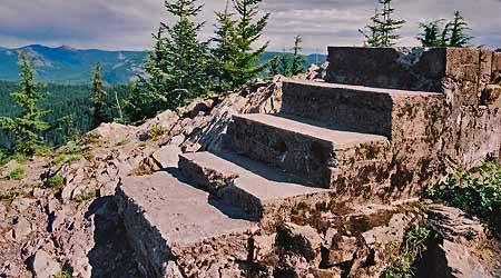
Stairway to the past, these steps once led to the lookout atop Tumala Mountain

Stairway to the past, these steps once led to the lookout atop Tumala Mountain

Today, the old road to the Tumala Mountain lookout site still exists, but serves mainly to deliver motorcycles and OHVs to the fragile mountain summit. The Abbot Road, itself, has become a sad, dangerous shooting gallery overrun by OHVs and target hunters. Tumala Meadows and Lakes are also within reach of the OHVs, despite efforts to keep them out of this remarkable basin.
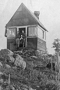
The original lookout on Tumala Mountain, pictured in 1916 (USFS photo)

The original lookout on Tumala Mountain, pictured in 1916 (USFS photo)

So the name change is a starting point, but the work here is unfinished. At Tumala Mountain, the solution is simple: the area must be managed for activities that build on the natural and cultural legacy, and help preserve the traces that still remain.

The first step in making this transition is to remove the shooters and OHVers from the area. Until they are gone, hikers, picnickers, cyclists and equestrians are unlikely to feel safe visiting the area, and the area will continue to suffer the abuse that is so evident today.

A message from the builders of the old lookout awaits hikers who discover the stairsteps that still remain

A message from the builders of the old lookout awaits hikers who discover the stairsteps that still remain

Unfortunately, the Forest Service is on the path to do just the opposite: the so-called “Mount Hood Travel Plan” currently underway has proposed that this area simply be written off as an OHV playground. This is unacceptable, and another reminder that the USFS agency mission simply does not allow it to behave as a responsible steward for the land.

But beyond the OHV problem, the second part of the puzzle is how to make the area more inviting for quiet recreation? There is no lack of scenery or interesting destination, after all. Indeed, this would most involve simple measures like better road and trail signs and improving lost campgrounds like those at Lookout Springs and Twin Springs — both would be excellent base camps for equestrians or cyclists. With a few improvements and the promise of finally solving the OHV and shooting problems, the area would become a prime outdoor destination.

This unfinished work can start now, by simply weighing in against the foolish, shortsighted OHV plan with the Forest Service. This would at least stop the bleeding.

But in the longer term, the unfinished work at Tamala — “tomorrow” — Mountain would be better managed by the National Park Service. Tumala is yet another reminder that the Forest Service cannot be trusted to protect and celebrate the natural and cultural legacy of Mount Hood.
Vision Quest Sites

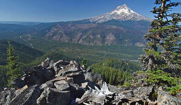
The Lookout Mountain vision quest site is perched high on rocky cliff

The Lookout Mountain vision quest site is perched high on rocky cliff

One of the great thrills of exploring remote mountain tops and rocky outcrops in the Mount Hood backcountry is stumbling upon a long-forgotten vision quest site. These are typically rock pits, large enough for a person — though modern visitors should never enter them, out of respect for both their spiritual and scientific significance.

Archaeologists are still debating the purpose of these pits. The most accepted theory is that these pits were built by Native Americans seeking a vision of their guardian spirit through a combination of physical exertion, deprivation and isolation. Under this theory, Native Americans would have spent several days building these pits, then meditating in them without food or human interaction in order to achieve a spiritual experience.

Other researchers argue that the pits were used as hunting blinds or to store food. But these alternative theories are hard to accept for locations like those around Mount Hood and in the Gorge. Most of this sites are on huge talus slopes or mountain tops, which would have been inconvenient as a food cache or for retrieving killed game.

The Lookout Mountain vision quest pit pictured here has still more mystery surrounding it. While the location of the pit is typical – high on a rocky knoll, overlooking the East Fork valley and Mount Hood – the walls of the pit are stacked higher and narrower than most, possibly due to the steepness of the site.

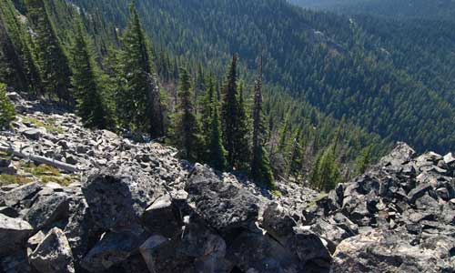
Looking down the steep slopes of Lookout Mountain from the vision quest pit

Looking down the steep slopes of Lookout Mountain from the vision quest pit

But even more perplexing are the worn traces of mortar between some of the stones (seen in the wall of the pit, toward the bottom of the second image). One possibility is that the mortar was an early attempt to preserve the site, given it’s fragile and exposed state. But who would have hauled both mortar and water to this site?

Perhaps early forest rangers who once manned a Forest Service guard station at High Prairie, a short distance away. The guard station was abandoned half a century ago, so this timing would be consistent with other, early 20th Century effort to “restore” Native American structures. This was famously done at several spots in Pueblo country, but might have happened here, too.

Whatever the answer, the Lookout Mountain vision quest site is among the most inspiring in the area, and it’s easy to imagine Native Americans seeking out spots like this for a spiritual journey. But it’s also easy to imagine sites like this being lost forever, for lack of a management imperative by the U.S. Forest Service to actively protect these places.

This kind of fragile resource is also among the best arguments for the Mount Hood National Park Campaign, since the Park Service has a long and proven track record of this sort of resource protection. In contrast, the Forest Service has aggressively logged much of the terrain around this site, oblivious to special places like this. So for now, obscurity is the best friend of these resources, until better stewardship finally comes to Mount Hood.

Just 75 Years

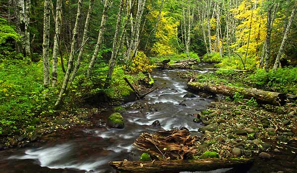
Autumn unfolds along McGee Creek, in the upper West Fork Hood River valley

Autumn unfolds along McGee Creek, in the upper West Fork valley

This scene in the headwaters of the West Fork of the Hood River was captured a few weeks ago, as early autumn colors began to sweep through the forest. This particular stream is McGee Creek, one of the larger tributaries that feeds the West Fork. Most hikers know McGee Creek from its alpine origins, where it tumbles from the wildflower meadows that sprawl below popular McNeil Point. But the creek soon enters lush forest on its way to joining the West Fork.

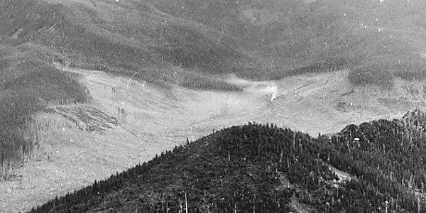
The surprise is that none of this existed just 75 years ago, when massive railroad logging operations had leveled the virgin forests of the West Fork. Look closely at the following image, captured in 1933 from high above the West Fork valley; the methodical clearing of the forests on the valley floor is nearly complete, and the steam plume from a log train headed back to the old mill town of Dee can also be seen:

By 1933, railroad logging had nearly cleared the West Fork valley

The steam engine in this old photo is at roughly the same spot as the autumn scene in the upper photo, illustrating the remarkable resilience of our forests. In about the span of an average lifetime — just 75 years — the forest along this stretch of McGee Creek has recovered from complete destruction, largely on its own. This is good news for other areas of Mount Hood and the Gorge that still show the scars of logging and road building. Given time and some modest restoration efforts, even the most damaged ecosystems will recover.

The autumn scene on McGee Creek also holds some lessons for restoration that may not be immediately obvious. The large log lying along the right side of the creek, for example, was carefully placed there by biologists, just a few years ago. This was in recognition that a century of logging has deprived our streams of large woody debris that turns out to be an essential ingredient for healthy fisheries.

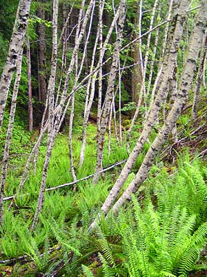
Perhaps most importantly, the white-trunked alders that line McGee Creek show that the forest here is recovering through natural succession. These pioneering trees provide quick cover and their dense root systems help prevent soil erosion.

Red alders are short-lived, adding their fallen debris to the rich duff layer they help build in recovering areas. Amazingly, they actually fix nitrogen in the soil through their roots, enriching it for the big conifers that will follow. Finally, the light canopy they provide allows for a complex understory of plants to develop in tandem with the alder groves, ensuring that forest diversity is re-established during the recovery cycle.

A typical red alder grove pioneering the recovery along an old road

A typical red alder grove pioneering the recovery along an old road

When McGee Creek was logged, the natural recovery that followed was mostly accidental — early timber operations viewed the forests as limitless, and logged areas were mostly ignored once the trees had been cut. The shift to cultivated tree farms didn’t begin until the late 1940s and the era of road-based logging.

In these more recently logged areas, the pioneer, non-commercial hardwoods like red alder were usually killed with herbicides in order to promote the quick growth of commercial timber species, especially Douglas fir. This practice has led to the thickets of crowded fir trees that we see today. These unnatural stands are vulnerable to disease and fire, and have almost no understory to provide for bio-diversity and wildlife habitat.

Sadly, it will take decades to thin these misguided plantations and decommission the failing logging roads that threaten streams and slopes. But though the task of forest recovery and restoration is a tall one, the good news is that the lessons of natural succession from places like McGee Creek have worked their way into forest management. Our scientists are now learning to work with nature, not control it — by letting the red alders grow.

As we continue to turn the page on past practices and begin a new era of restoration for the forests of Mount Hood, we can take some degree of consolation in knowing that a complete recovery is well within our reach. By watching and learning from the forest ecosystem, we now realize that the natural processes that have renewed our forests for millennia must be allowed to follow their ancient course, once again.

Reid Glacier

Soft evening light on Reid Glacier and Illumination Rock

Soft evening light on Reid Glacier and Illumination Rock

Reid Glacier, on Mount Hood’s rugged west flank, is one of the most interesting of the mountain’s 12 glaciers. This tumbling body of ice flows between the towering walls of Yocum Ridge and Hawkins cliffs, with the tall spire of Illumination Rock soaring above its deep crevasses. Oddly, Reid Glacier is the source of the Sandy River, whereas the Sandy Glacier gives birth to the Muddy Fork – some confusion on the part of early cartographers, perhaps? And while the Reid is among the most visible of Hood’s glaciers from Portland, few hikers actually make the long climb to the high meadows of Yocum Ridge for a close-up view of the glacier.

USGS view of the Reid Glacier

USGS view of the Reid Glacier

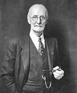
Reid Glacier is also unique as the only one of Mount Hood’s glaciers that wasn’t named for a local pioneer, or simply given a descriptive name. Instead, this secluded river of ice was named to honor Harry Fielding Reid, the eminent geophysicist who is considered to be the father of modern thinking on faults and tectonic forces.

Harry Fielding Reid (1859-1944)

Harry Fielding Reid (1859-1944)

Reid never actually visited the glacier, though he was an avid mountaineer and did study the White River Glacier extensively. The Mazamas honored Reid by naming the glacier for him at a campfire ceremony held on the mountain on July 16, 1901.

Harry Fielding Reid’s research took him around the world, and his groundbreaking work at Glacier Bay in Alaska was recognized by the naming of yet another Reid Glacier for the scientist. The Alaska glacier by the same name is much larger, of course, and is a tidewater glacier flowing into the Reid Inlet in Glacier Bay. Thus, the smaller Reid Glacier on Mount Hood lives in the shadow of its larger sibling in Alaska, with few biographies of Harry Reid making mention of the more diminutive Mount Hood namesake.

Today, the Seismological Society of America awards its top honor, the Harry Field Reid Medal, for outstanding contributions to the fields of seismology and earthquake engineering.

Just Two Dead Trees

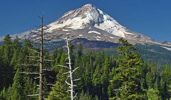
The two snags and Mount Hood in September 2008

The two snags and Mount Hood in September 2008

For many years, I’ve stopped at a favorite vantage point along Dufur Mill Road to photograph the massive east face of Mount Hood, framed by a trio of big ponderosa pines. In the beginning, two were living, and the third was a bleached, dead snag that stood between them. Then another died just a few years ago (the tree on the left in the photo), creating a new snag.

Each year, the two snags in this trio have become more weathered, with the remaining bits bark dropping from the silver wood of the older snag, and a few more branches dropping from the younger skeleton. I watched this evolving scene with interest, but also took for granted. I was thus surprised — and saddened — to discover that these two, old sentinels had been cut down sometime this fall.

They were left simply lying on the ground, in the ravine far below the road, and it’s unclear why they were cut. When I was there, a pair of grizzled men were cutting firewood along the road, a sanctioned activity permitted by the Forest Service. Yet, these two great snags were far enough below the road to represent a real chore to recover as firewood. Indeed, the men were working the uphill side of the road, where logs could simply be rolled down to their truck. More to the point, there is plenty of downed timber for woodcutting in the area, so it was unnecessary to cut any snags, much less these two giants.

But somebody felled them, and this is just one price of the casual culture of tree cutting that reduces every standing tree on U.S. Forest Service land, dead or alive, to a dollar value in board feed of lumber, or cords of firewood or cardboard boxes. What a waste.

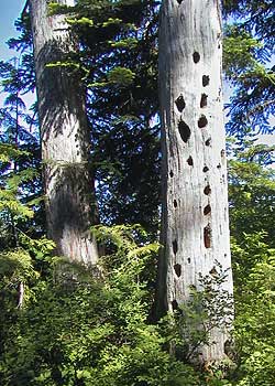
Two more fortunate snags live on as wildlife trees near Lost Lake

Two more fortunate snags live on as wildlife trees near Lost Lake

So this story remains a puzzle to me. I doubt many noticed these two old snags, but they surely added to the scene in ways both aesthetic — they were majestic and photogenic — and functional, since big snags are an important part of a diverse wildlife habitat in our forests. I’d often seen crows, and even a couple of hawks, sitting in these old snags over the years, and there were probably dozens of other creatures that lived in these old skeletons, or relied on them for survival.

They might have lasted for decades as bleached monuments, too. Mount Hood is dotted with century-old snags left from fires that occurred in the early 1900s, after all, since big trees like these have remarkable resistance to the elements as snags. But this pair will only remain standing in my imagination, and I’m thankful that I captured them in a few photographs over the years as a reminder of their beauty and value.