
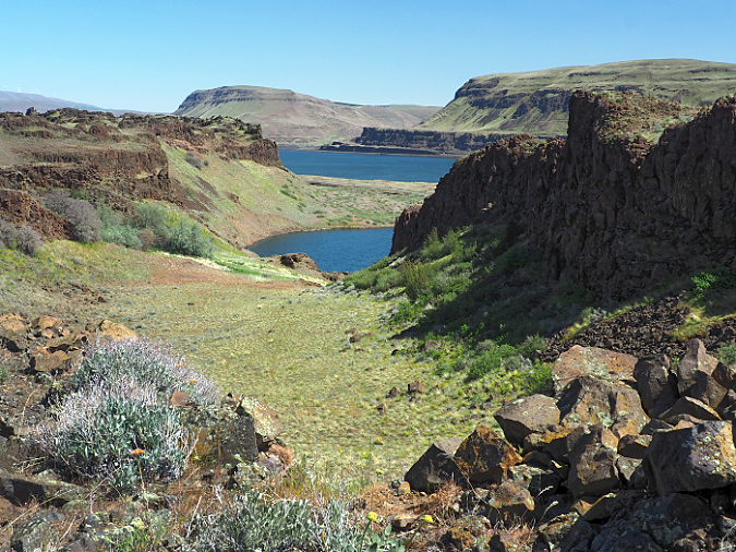
Do you take scenes like this in the eastern Columbia River Gorge for granted? Read on…
As we slowly emerge from a year of pandemic, three milestones in Columbia River Gorge news are noteworthy for those who love WyEast Country. What do they have in comment? In each case, the multi-layered governance (or lack thereof) in the Gorge continues to be a hurdle, even when the news is very good… or even great!
The Great: Mitchell Point Tunnel Project
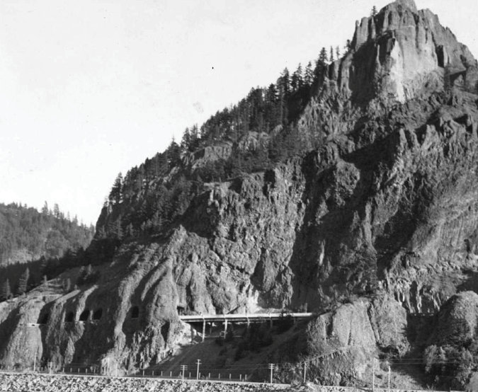
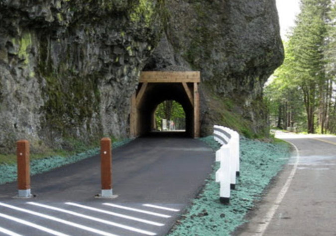
For many years the Oregon Department of Transportation (ODOT) has been quietly moving toward actually replacing the legendary Mitchell Point “tunnel of many windows” with a new windowed tunnel. The new tunnel is along the bike and pedestrian trail that ODOT has been building to reconnect the original Historic Columbia River Highway, and construction began this spring. It’s a bold and visionary project, and another dramatic nod toward historic restoration along the old route. The former Oregon Highway Division destroyed the original tunnel in the 1966, when it was deemed a hazard to traffic on the modern freeway being constructed directly below, and it has been a dream for many to see it restored ever since.
The new 655-foot tunnel will have five arched windows, roughly patterned after the original Mitchell Point Tunnel. When completed, the tunnel will become the crown jewel of the larger Historic Columbia River Highway State Trail, a concept 35 years in the making, with just five miles of trail remaining to be constructed. When the last five miles are complete, the trail is destined to become a world-class cycling destination that will allow visitors to ride from Troutdale to The Dalles without traveling along the modern freeway.
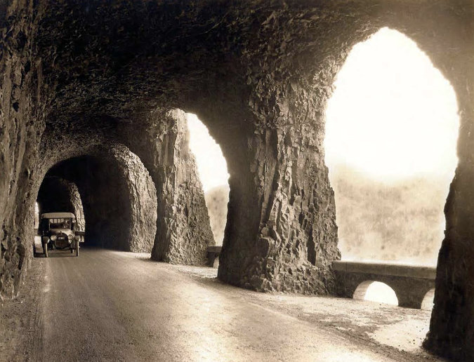
The iconic Mitchell Point Tunnel was completed in 1915, but it was destroyed by freeway construction just 51 years later in 1966. It lives on in our collective memory as the greatest engineering marvel of the original Columbia River Highway
This 1920s view of the original Mitchell Point Tunnel from the Washington side of the Columbia River shows both west viaduct that led to the tunnel and the famous series of windows (on the left). Freeway construction at the base of the cliffs in the 1960s destroyed both the tunnel and viaduct
The new Mitchell Point Tunnel will enter the basalt walls of Mitchell Spur, the smaller, northern offshoot of Mitchell Point, proper, and connect the existing Mitchell Point Wayside on the west side of the spur to a future trail and historic highway alignment east of Mitchell Point. Between the two new tunnel portals, five windows will frame Gorge views and light the way for visitors, providing an experience similar to what early motorists enjoyed from their Model-Ts in the early 1920s.
ODOT has posted a video on YouTube with drone footage and more background on the new tunnel:
While the new tunnel is certain to draw visitors who simply want to walk its length and enjoy the views, it also offers a terrific opportunity to create loop hikes that build upon the existing Mitchell Point Trail. This steep and difficult to maintain route is more like a goat path, but has become an increasingly popular viewpoint trail as placed like Angels Rest become overwhelmingly crowded. The Oregon Department of Parks and Recreation (OPRD) has already adopted a new loop trail concept for the west side of Mitchell Point that also would provide a better graded approach to the summit, and a loop for those willing to return along the existing, very steep route.
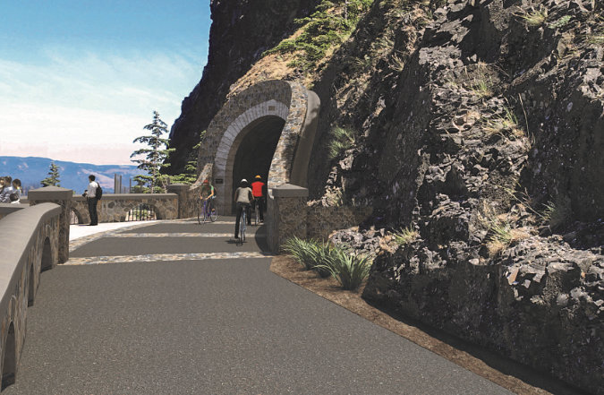
This ODOT rendering shows the planned approach to the west portal of the new Mitchell Point Tunnel from the perspective of the Historic Columbia River Highway State Trail, which currently stubs out at these cliffs (ODOT)
This rendering also shows the new west portal that ODOT is constructing for the new Mitchell Point Tunnel. A bump-out viewpoint (on the left) is also included in the design (ODOT)

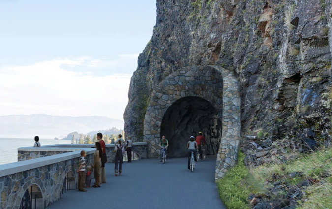
This concept shows the design for five windows that will be incorporated into the new tunnel at Mitchell Point. ODOT describes the tunnel interior as “modern concrete”, so the exposed rock surface in this rendering and visible in the previous portal rendering may not be part of the final plan (ODOT)

This view shows the existing overlook at the Mitchell Point Wayside, where the paved trail stubs out at berm at the base of Mitchell Spur’s cliffs. The west portal to the new tunnel will enter the cliff visible just beyond the berm, at the right in this photo. The berm will be removed to extend the trail to the new tunnel portal.
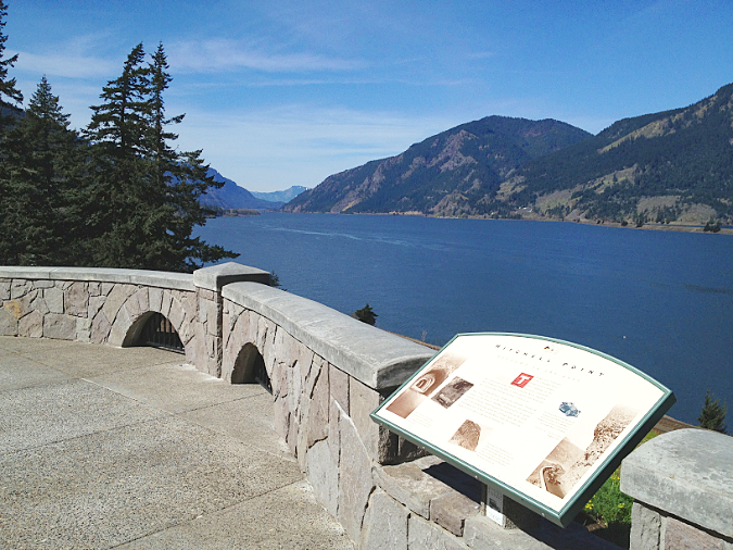
The west portal design for the new tunnel preserves this relatively new (2013) overlook at Mitchell Point, already a popular stop for Gorge visitors
The new tunnel also offers a loop trail opportunity from the east side of Mitchell Point, with the tunnel providing a return to the main trailhead. Loop trails are popular with hikers because you get to see more scenery for your effort. But they can also be managed as one-way trails where crowds are a problem, greatly lessening the impact of passing hikers on heavily traveled trails. The OPRD plan for the Gorge also includes a loop trail concept for Angels Rest with this exact purpose in mind. From a hiker’s perspective, one-way loops also mean encountering far fewer people along your hike, so it can greatly improve the outdoor experience.
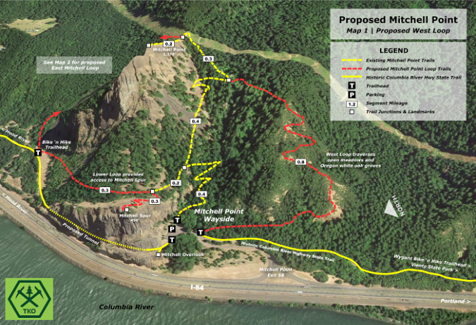
[Click here for a larger Mitchell Point West map]

[Click here for a larger Mitchell Point East map]
Will Mitchell Point become as crowded as Angels Rest? Maybe someday, though not anytime soon, simply because it’s much farther from Portland. But it will certainly become more popular than it is today, as foot traffic here has steadily grown over the past decade or so. With this in mind, one of the disappointments of the Mitchell Point project is the failure to plan for future crowds, and especially to differentiate between visitor types in the planned parking improvements. In the past, most visitors to Mitchell Point were there to walk to the existing overlook at the wayside, spending just a few minutes there while on their driving tour of the Gorge. Hikers, meanwhile, can spend several hours laboring up the steep path to the summit.
Currently, both kinds of visitors compete for the same limited number of parking spots at Mitchell Point. As with unmanaged waysides elsewhere in the Gorge (Latourell Falls, Wahkeena Falls, Starvation Creek are just a few examples), hikers are now filling all of the spots at Mitchell Point on weekends, leaving touring families with no place to park. The new ODOT plan will create 18 parking spaces (including one disabled spot) compared to 16 today (including two disabled spaces). The net increase of two parking spaces is a drop in the bucket for this increasingly popular trailhead.
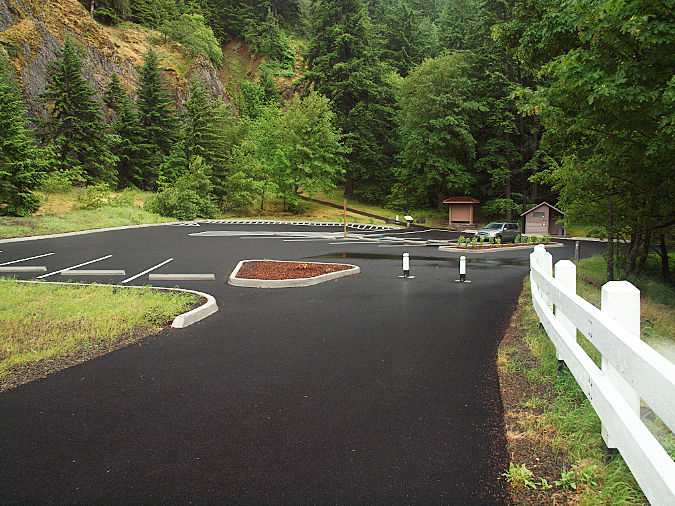
The existing parking area at Mitchell Point is relatively new – completed in early 2013, when this photo was taken. It provides a total of 16 parking spots, including two disabled spots. The construction of the Mitchell Point tunnel includes a complete reconstruction of the existing parking area
There are a couple of solutions that ODOT and OPRD could easily incorporate into the current construction phase without rivisitng the basic parking plan. First, mark a few parking spots for short-term, 30-minute parking for touring motorists to visit the wayside viewpoint and walk the new tunnel. Yes, it would have to be enforced to be effective, but even sporadic enforcement with a healthy fine would send a shockwave through hiking social media sites.

This is an ODOT rendering of the new parking area at Mitchell Point. While it’s surprising to see the fairly new parking lot being reconstructed so soon, the new design does manage to have a smaller paved area while expanding parking spaces (to a total of 18 compared to 16 today) and has a more efficient circulation design. The areas shown with picnic tables were once part of a very large parking area here as recently as 2012, so it’s disappointing that this design doesn’t better accommodate demand by included more spaces in that area (ODOT)
Second, ODOT and OPRD could take formally advantage of the long access drive to the Mitchell Point Wayside to allow for overflow parking. At a meeting of the Historic Columbia River Highway Steering Committee last summer, I asked if overflow shoulder parking would be allowed along the access road, and the ODOT response was a disappointing “no”.
That’s not only short-sighted, it’s also a state of denial. Already, the nearby Starvation Creek wayside routinely has cars parked along both the access and exits roads, all the way to the freeway, for lack of a trailhead space and an effective parking management plan. As a result, weekend touring motorists hoping to visit the falls or use the restrooms at Starvation Creek have no prayer of finding a spot, as the entire lot is packed with hikers, most of them on hours-long hikes to the summit of Mount Defiance. That gives ODOT and OPRD a black eye, and a similar situation will surely unfold at the new Mitchell Point trailhead if parking isn’t more actively managed.
The Sad: Oneonta Tunnel Restoration

The Oneonta Tunnel in about 1915,, soon after it opened and before this section of the Historic Columbia River Highway was paved
In other tunnel news, ODOT recently (re)completed the restoration of the Oneonta Tunnel, near Multnomah Falls. The agency once again rebuilt the timbered interior of the tunnel, restoring work that was originally done back in the mid-2000 and completely burned in the 2017 Eagle Creek Fire. It’s a beautiful restoration effort, and you should go see it soon, before it is once again destroyed by vandals carving up the restored woodwork. Because that sad fate is all but inevitable.
I wrote about this project recently in A Second Chance and New Vision for Oneonta? While there may be no appetite at ODOT or OPRD to pursue something more whimsical (like the museum proposed in the previous article!), it is frustrating to see the new restoration completed with zero consideration given to protecting the public’s investment from vandals. At the same meeting of the Historic Columbia River Highway Steering Committee last summer, I asked ODOT officials if there was a plan to secure the tunnel with gates of some kind, and the response was “no, because under national scenic area regulations, we can only restore it to its exact condition before the fire.”
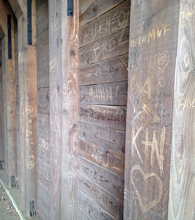
Mobs of young people descended on Oneonta Gorge each summer before the 2017 Eagle Creek Fire closed the area. Many made a point of vandalizing the wood interior of the Oneonta Tunnel while they were there
Still more frustrating is the fact that top officials from the U.S. Forest Service and ODOT who oversee funding for Gorge projects and scenic area regulation were part of this virtual meeting, and sat in silence when I asked whether this was a good use of public resources. Another committee member commented that vandalism in the form of tagging and graffiti has always been a problem in the Gorge. Perhaps, but is the point is that we shouldn’t care?
Well, I’m still not buying it. If there is one thing that’s certain for large, well-funded agencies like the Forest Service and ODOT, it’s that where there is a will, there is a way. The cost to install gates would have been negligible compared to what ODOT budgets for the Gorge in a given year, and surely would be less costly than another redo in the coming years. In this case, there was simply no agency interest from the Forest Service or ODOT in protecting the newly restored tunnel, and that’s really discouraging.
ODOT completed the second restoration of the Oneonta Tunnel this spring, replacing the wood lining that was burned away in the 2017 Eagle Creek Fire. Despite its recent history of vandalism, the tunnel is now open and completely unprotected, night and day
So, as lovely as the (second) restoration of the Oneonta Tunnel is, it falls under the column of “sad” for its poor stewardship of both the historic resource and the public funds spent to restore it. But who knows, maybe once the tagging starts up and triggers some unwelcome local media coverage, we’ll see some protection installed? A late response would be better than not at all, and I’d sure like to be proven wrong on the fate of the old tunnel.
The Ugly: Columbia Hills Energy Project

These beautiful, mosaic talus slopes along the Columbia Hills are ground zero for a proposed energy project that threatens to change the area forever. A jarring sea of giant wind turbines were installed along the crest of what is a sacred ridge for area tribes over the past 15 years, and now the turbines are the basis for still more energy development in this unprotected part of the Gorge
I will reluctantly end this article with one of the toughest development proposals to emerge in the Gorge in recent years. As ugly as the project is, however, the picture is not entirely bleak. The proposal is formally known as the “Goldendale Energy Project”, taking its name from what used to be the Goldendale Aluminum Plant, located adjacent to the John Day Dam in the eastern Gorge. But the site is miles away from Goldendale, Washington, and more importantly, it’s within the Columbia River Gorge and centered on Columbia Hills, a place sacred to area tribes. So, I’ve called it the Columbia Hills Energy Project for this article.
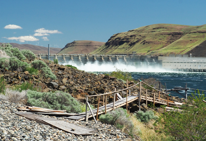
The aluminum plant at the John Day Dam went out of business decades ago, leaving badly polluted soils and groundwater behind where smelters once stood. It has since been undergoing a gradual cleanup operation, work that is ongoing. The Columbia Hills “stored energy” project proposes to build a large water storage basin in this polluted brownfield, connected by pipes to a second basin at the crest of the Columbia Hills, 2,000 vertical feet directly above the John Day Dam and the old aluminum plant site. When wind turbines are generating excess energy, water from the lower basin would be pumped to the upper basin, and could then be released back down to the lower basin to power hydro turbines during periods of peak demand (or low wind).
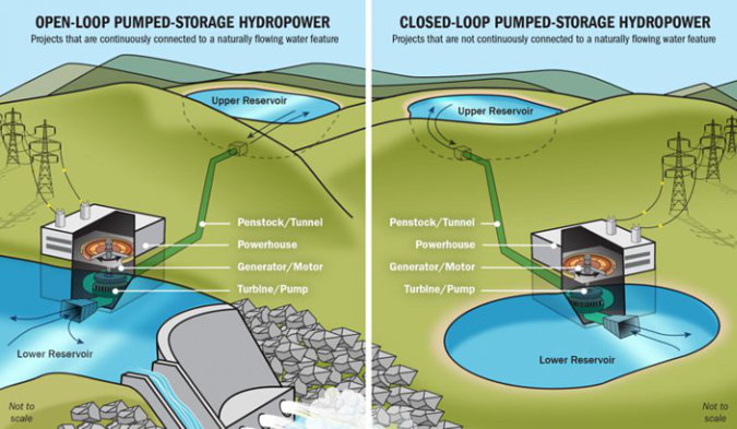
The system on the right is proposed for the Columbia Hills (Rye Development)
To the Ka-milt-pah band of the Yakima Nation (known in English as the Rock Creek Band), the Columbia Hills here are sacred. Their significance goes to the very creation of the Columbia Gorge, itself. Scientists believe the ice age Bretz (or Missoula) floods continued to repeatedly overwhelm the Gorge with hundreds of feet of water for nearly 2,000 years, finally ending some 13,000 years ago. Virtually every aspect of the Gorge as we know it was shaped by the floods, including the steep, exposed cliffs and rock monoliths that give the Gorge its iconic beauty. Their oral tradition tells us that the ancestral Ka-milt-pah people climbed to these ridge tops to escape this series of massive ice-age floods, watching the cataclysm from these high vantage points.
Today, the Ka-milt-pah continue to gather first foods from these same hills, though now with the permission of farmers who own deeds to the ceded tribal lands here. In yet another insult to traditions and the defacement of their sacred places, tribal members now must gather foods under the shadow and hum of giant wind turbines that send “green” electricity to Portlanders. Unseen to urbanites are the miles of gravel access roads that were cut into pristine desert soils along these ridges to build and maintain the turbines, destroying still more of the ecosystem that the Ka-milt-pah people relied upon for millennia. And in yet another cruel irony, the windmills are now are central to the Columbia Hills Energy Project, as well.
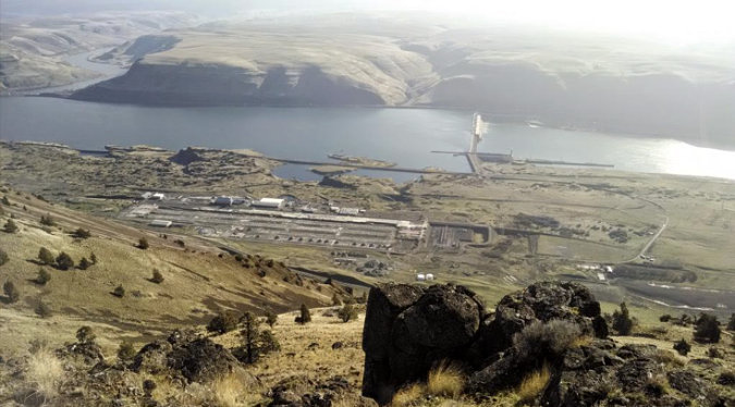
The defunct, polluted aluminum plant at John Day dam (seen far below in this view) is proposed to hold the lower reservoir for the closed-loop energy system. This view is from the crest of the Columbia Hills, on sacred tribal land 2,000 feet above the river, where the upper reservoir would be constructed (Portland Business Journal)
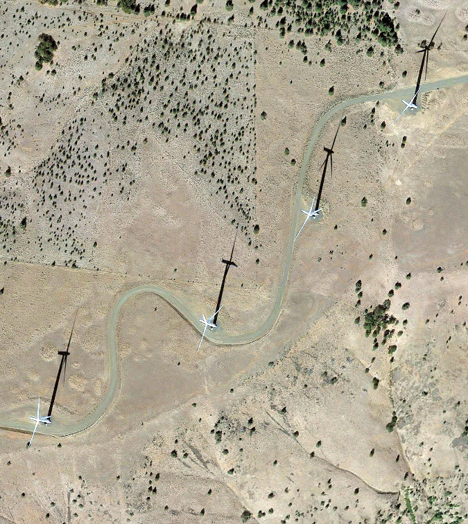
The towering wind turbine that now line the Columbia Hills above John Day Dam are aggressively marketed as benign sources of clean energy, and yet each turbine requires a new road to be built, leaving a permanent scar on the land and introducing invasive plants to the largely pristine desert landscape. This snaking section of road in this view is on sacred tribal land near the proposed Columbia Hills Energy Project (Google Earth)
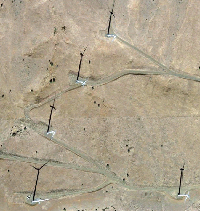
The service roads built for these windmills on the crest of the Columbia Hills resemble suburban cul-de-sacs, each cut into desert ground that had never even been plowed, and has provided tribal first foods for millennia (Google Earth)
Did you know that the stunning stretch of the Columbia River Gorge east of the Deschutes River does not enjoy the protections provided by the Columbia River Gorge National Scenic Area (CRGNSA) to areas west of the Deschutes? The most jarring evidence of this second-class status are the hundreds of massive, white wind turbines that now dot the Columbia Hills along this unprotected stretch of the Gorge, from Maryhill Museum east to the John Day river and beyond. The visual impact of these turbines therefore wasn’t even a factor when they were constructed over the past 15 years.
It is truly a miracle and testament to the tenacity of Gorge advocates in the 1980s that we even have a CRGNSA to protect the Gorge, yet it’s also true that leaving the eastern portion of the Gorge out of the bill left the area tragically vulnerable to energy and development schemes that continue forever scar the Gorge we shall leave to future generations. The Columbia Hills Energy Project may be the latest scheme, but it certainly won’t be the last (lesser-known fact: the Maryhill Museum was among the opponents of the CRGNSA in the 1980s, which explains the forest of windmills that now mar the Gorge rim directly above the museum and continue for miles to the east).
The ancient and sustainable trumped by the new and industrial: the 1971 John Day Dam dwarfs traditional tribal fishing platforms, located just downstream from the dam
For the Danish corporate investors behind this project, the windmills along the Columbia Hills provide a world-class opportunity for pumped storage development. The hills rise anywhere from 1,200 to 2,000 feet above the Columbia River, a ready source of water to fill storage tanks. That’s probably as much as they know. The fact that it’s also remote from Portland urbanites who might otherwise be shocked to see a development of this scale proposed in “their Gorge” is just good fortune for the investors.
And so, it has fallen to the Confederated Yakima, Umatilla and Nez Perce nations to defend their homelands from yet another assault by Europeans seeking to, once again, commodify their native lands.
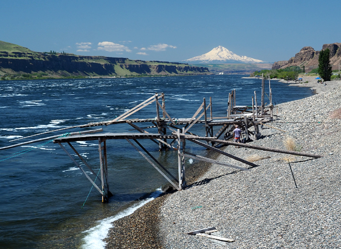
Countless generations of tribal fisherman have harvested salmon on these pebble beaches in the east Gorge for millennia. The lower reservoir for the proposed “energy loop” would be a stone’s throw from this iconic scene. Is it even possible to measure economic impacts of energy project against threats to the very culture of indigenous people?
The pace of change in the eastern stretch of the Gorge has been breathtaking in the past few decades. In 1957 – just 64 years ago — the gates on The Dalles Dam closed, drowning Celilo Falls and surrounding tribal settlements under 40 feet of water. This ended a way of life for indigenous peoples who had thrived here for thousands of years. Nine years later, in 1966, ODOT blasted and filled a 4-lane swath through the Gorge to construct today’s Interstate-84, destroying miles of wetlands and beaches along the way, and cutting off access to traditional tribal fishing sites in the process. In 1971, the gates were closed on John Day Dam, at the head of slackwater created by The Dalles Dam. Another stretch of rapids along the once-wild river disappeared, along with more beaches and wetlands.
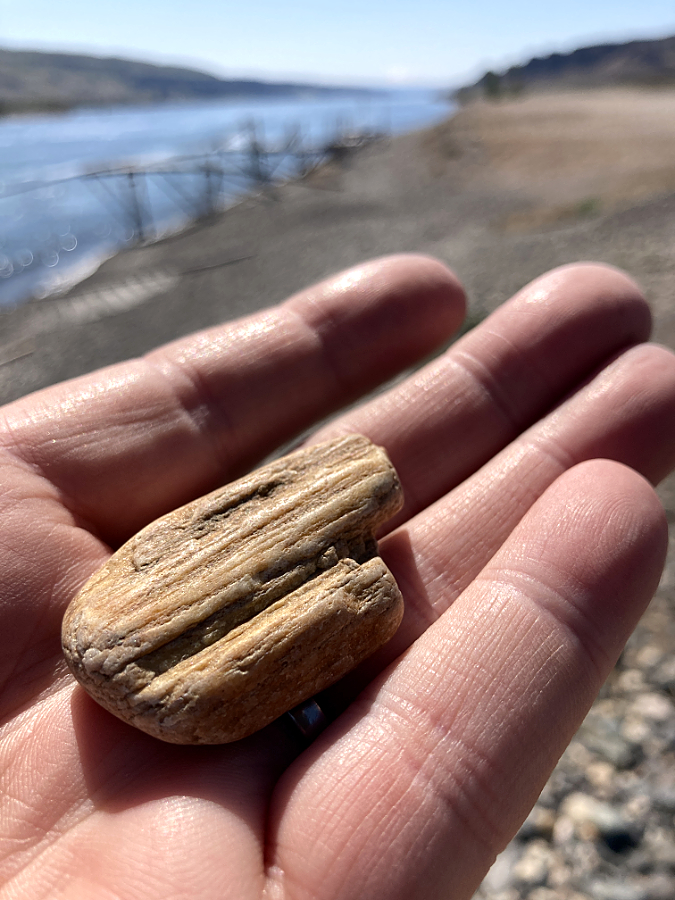
The vast, colorful pebble beaches in the east Gorge were left here by ice age floods that brought rock from the northern Rocky Mountains to the Columbia River Gorge. This river-worn piece of petrified wood is typical of these deposits
Both dams brought hundreds of steel transmission towers and thousands of miles of electrical cable that now drapes across the once-pristine Gorge landscape. And in the 2000s, big utilities rushed after state and federal renewable energy tax credits to line the Columbia Hills with hundreds of windmills, many built on sacred tribal sites. It’s true, these are all renewable energy sources that our region depends upon to power our homes and industry. Yet, it’s also true that our cheap energy has come at a catastrophic cost to tribal culture and economies, and wreaked havoc on one of the most spectacular natural landscapes on the planet. Isn’t it time to question just how “green” the energy harnessed in the Gorge really is?
Fortunately, a broad coalition of conservation advocates have joined the tribes in challenging the Columbia Hills Energy Project. They include both the Oregon and Washington chapters of the Sierra Club, the Northwest Environmental Defense Center, Columbia Riverkeeper, Food and Water Watch, Portland Audubon and several other organizations. This is encouraging, as corporate energy projects are famously costly and drawn-out battles with deep-pocketed (and often foreign) investors who are willing to ride out the opposition and ingratiate themselves to local elected officials. Witness that Washington Governor Jay Inslee recently signed a fast-track provision for energy storage projects just like this one (though we don’t know his position on this specific proposal).
This lovely desert gulch along the Columbia River is immediately adjacent to the proposed Columbia Hills Energy Project. How will it be impacted? We don’t know yet…
Thankfully, the Washington Department of Ecology has determined the project to have “significant environmental impact”, ensuring that some rigor will be applied in the state permitting review. Whether that review can truly measure the impact of this proposal on tribal rights and traditions remains and open question that courts will likely have to decide.
Yes, stored energy projects are a good idea. They’re a creative, sustainable solution in a world facing a global climate crisis. We should welcome them!
Just not here.

Tom, thank you for another fine (and educational) post!
Mitchell Point — it is wonderful that ODOT is restoring the tunnel to its HCRH condition. And the proposed Mitchell Point trail system would be terrific! But it is unfortunate that ODOT has chosen to ignore the problem three miles to the west (i.e., the perpetually overflowing “Starvation Creek Trailhead Parking Area”) when considering the parking situation.
Oneonta Tunnel — It is great to see a well-loved HCRH site restored *again* (after the Eagle Creek fire destroyed its 2009 incarnation). But, like you, I am aghast that ODOT / OPRD / USFS have zero interest in protecting it from the inevitable onslaught of graffiti and vandalism. The ODOT HCRH Advisory Committee held a virtual meeting two weeks ago, and I submitted a comment *begging* them to reconsider this while there was still time to protect the tunnel. (There has been no response thus far, nor do I expect to receive one.)
Goldendale Energy Project — this is yet another slap in the face to Native Americans, just a few miles away from drowned but never forgotten Celilo Falls. It is good to know that conservation groups are fighting it, and that WA Dept of Energy is not fast-tracking it. I agree completely that stored energy projects are sorely needed, but surely they can be implemented in a less intrusive way without environmental, historical, and psychological damage.
LikeLike
Thanks Tom. I love reading your articles. I love the fact that we are slowly being able to enjoy once destroyed places again, such as the old highway, but as you highlight, man has truly noble intentions, but fall way short of perfection. Until that changes, we’ll just have to limp long with what they offer.
LikeLike
Thanks, Mike and Chaz – much appreciated!
LikeLike