A New Vision for Mirror Lake (Part 2 of 3)

MirrorLake2.01

Today’s Mirror Lake trailhead will soon be history

 Big changes are coming to the Mirror Lake Trail on Mount Hood, perhaps the single most visited trail on the mountain. This is the second of three articles on the future of Mirror Lake, and the need for a broader vision to guide recreation in the area. This article focuses on the alternatives under consideration for a new trailhead.

____________

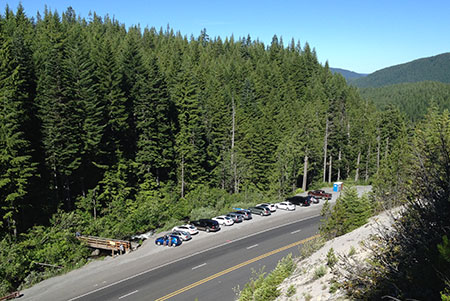
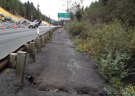
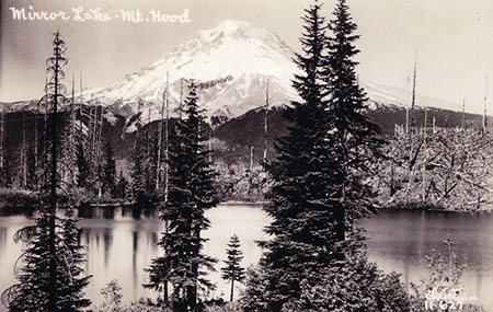
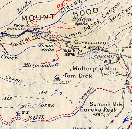
It’s true. We’re about to lose the historic Mirror Lake trailhead along Highway 26. If you’re like me (and countless other Oregonians), you might have been introduced to hiking and the great outdoors along this classic family trail.

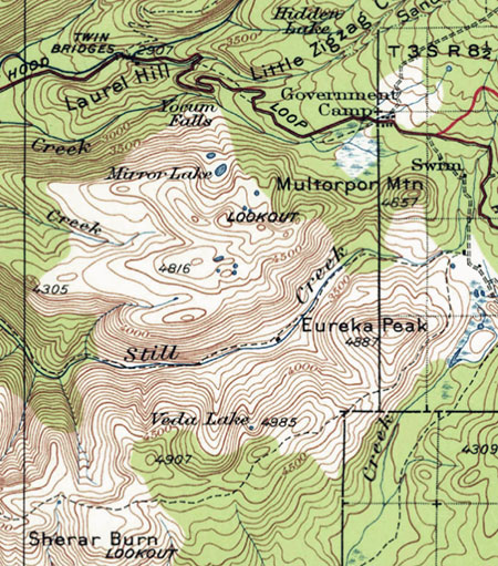
The visibility and convenience of the Mirror Lake trailhead, with its prominent location along the last bend of the Mount Hood Loop Highway as you approach Government Camp, is one of the main reasons this trail has functioned as a “gateway” for novice hikers, stopping at the first trail they see. The short hike to the lake has also made this trip friendly and fun for families with very young kids.

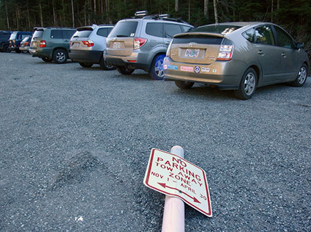
Until recently, the Mirror Lake Trail was also the perfect place to learn the sport of snowshoeing — until the Oregon Department of Transportation (ODOT) closed the trailhead to winter parking in 2010, that is.

MirrorLake2.02

Low snowfall in the winter of 2010 meant the first winter closure of the Mirror Lake trailhead went largely ignored, though the closure has become real in subsequent years

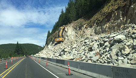
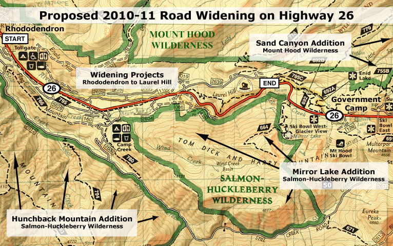
The 2010 winter closure foreshadowed the future, as ODOT always intended to close the trailhead entirely. Now, after years of back and forth with the Forest Service and an array of advocacy groups, and ODOT has won this battle. ODOT’s determination to morph our loop highway into an urban-style freeway came in the form of the $37 million widening project now underway (read more about there here: https://wyeastblog.org/2014/06/30/u-s-26-construction-begins/), and in the tradition of most state highway departments, it was an unstoppable force.

Planning the New Trailhead

Now that the Forest Service has agreed to relocate the trailhead, a little-known branch of the federal government known as the Western Federal Lands Highway Division is taking the lead on finding a new site on behalf of both ODOT and the Forest Service. The planning process kicked off in earnest on October 29 with a lightly attended open house at the Zigzag Ranger District, and the proposal details have since been added to the project website.

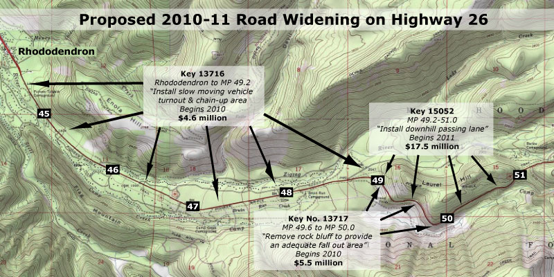
You may have seen other changes in the area. ODOT is midway through a major widening of the Mount Hood Highway that will bring a freeway-style concrete barrier to the entire Laurel Hill grade, from Government Camp all the way down to the Kiwanis Camp Road (the old highway section that leads to Little Zigzag Falls).

MirrorLake2.03

“New and improved” highway scars like these along the Mount Hood loop are part of ODOT’s plan to allow weekend skiers to drive just a bit faster

This means the historic trailheads at Laurel Hill and Mirror Lake will only be accessible from the eastbound highway. Portland area hikers leaving Mirror Lake would need to drive east to Government Camp and turn around to head west. Likewise, hikers coming from the east would need to drive to the bottom of the hill, and turn around at Kiwanis Camp Road to reach the Laurel Hill and Mirror Lake trailheads.

Given the implications of the new highway median, the Forest Service has conceded to move the trailhead, and not further explore options for keeping the historic trailhead open to general use. To help this effort, the Forest Service received a grant in 2014 that helped fund the analysis of different trailhead options.

MirrorLake2.04

(click here for a larger map)

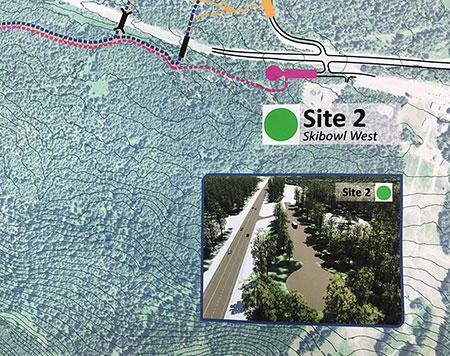
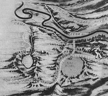
The most promising of the various trailhead options under consideration from a logistics standpoint is simply using the Ski Bowl parking area (which, like the rest of the Ski Bowl land, is owned by the public with a long-term lease granted to Ski Bowl to operate here). Not surprisingly, the resort is concerned about sharing their highway access, and was present at the October 29 project open house.

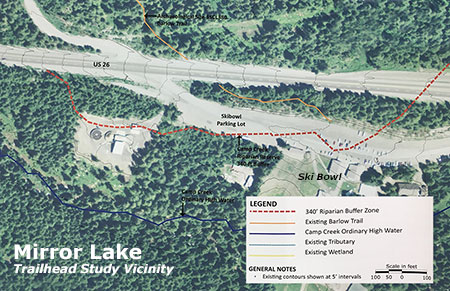
Despite the resort’s concerns, the FHWA and Forest Service have nonetheless ruled out other possible sites (described later in this article), and are now focused solely on the Ski Bowl site with several design options under consideration. The following map shows the four options in relation to the Ski Bowl parking lot:

MirrorLake2.05

(click here for a larger map)

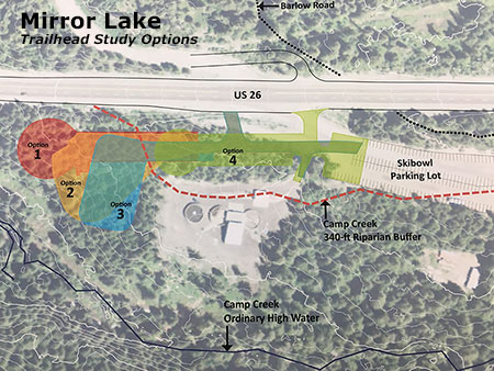
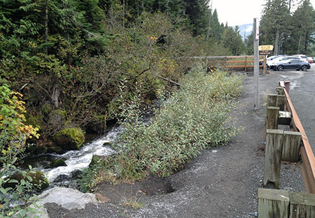
The preferred site has other complications. Much of the land here is within a protected stream buffer that follows Camp Creek. Government Camp’s sewage treatment facility is also located here (in the center of the map, above, and pictured below), and must be designed around for both security and aesthetic reasons.

MirrorLake2.06

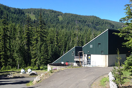
The Government Camp sewage treatment plan hides just behind a thin band of trees along the Ski Bowl parking area.

The new trailhead project proposes about fifty parking spaces in the new parking area. That sounds small (and is), considering the crowds on a typical weekend at Mirror Lake, but that’s intentional. The Forest Service is looking to reduce the human impact on Mirror Lake, with a parking area sized to what they see as the optimal maximum for the area (more on this later in the article).

With the proposed new parking area and trail located adjacent to Ski Bowl, there is obviously a large existing parking area that will allow a lot more than 50 cars at trailhead in the off-season for the resort, so it’s unclear of limiting the number of spaces can really limit the number of hikers on the trail. The Ski Bowl resort’s concerns are mostly about winter use, when snowshoers and backcountry skiers could overflow to use the resort parking area and displace resort visitors.

MirrorLake2.07

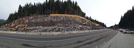
Panorama of the massive new road cut underway opposite the historic Mirror Lake trailhead on US 26; a concrete median will soon be added here.

The Forest Service and ODOT are proposing to plow the new trailhead parking area in winter and (presumably) add it to the SnoPark system, so this represents a big improvement over the current situation.

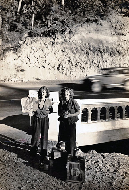
Since the ODOT winter closure of the existing trailhead was put in place, snowshoers have simply walked the shoulder of Highway 26 from Ski Bowl to gain access to the historic trailhead — a potentially dangerous (and rather scary) idea. Providing plowed winter access at the new trailhead should resolve this problem.

Another benefit of locating the new trailhead at the Ski Bowl site is proximity to Government Camp. The village has been working hard to become a year-round resort community with a network of new trails now surrounding the community. All four design options would create much better access to Mirror Lake and the surrounding wilderness area for Government Camp visitors and residents, albeit with a sketchy highway crossing.

Considering the Options

With the approximate site for the new trailhead already selected at Ski Bowl, the FHWA and the Forest Service are now concentrating on design options. The Ski Bowl site has many physical limitations, so the focus is on how to integrate the new trailhead with the various site constraints presented by the proximity to Ski Bowl, including the wastewater treatment plant and a 340-foot protected buffer along Camp Creek, itself.

The first design (Option 1) features a suburban style cul-de-sac that would double back from the west approach along Highway 26, running parallel to the highway:

MirrorLake2.08

(click here for a larger map)

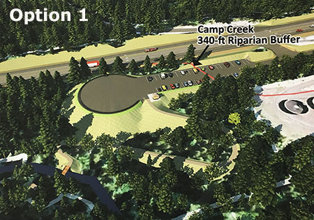
This option would require a lot of tree removal as well as extensive fill under the turnaround portion. It would also extend into the protected buffer along Camp Creek. The turnaround is oversized for snowplows, but this design also creates a practical parking enforcement issue during the snow-free seasons, as hikers would almost certainly park in the turnaround during busy summer weekend.

The second design (Option 2) features a triangular loop tucked behind the wastewater treatment plant:

MirrorLake2.09

(click here for a larger map)

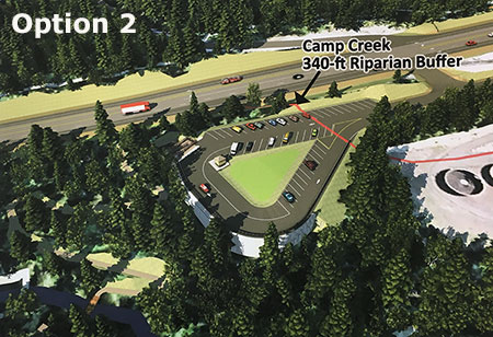
This design is an improvement over the first option because it allows for more efficient plowing and use of paved areas. The landscaped center area could even function as a useful place for a few picnic tables for waiting visitors meeting at the trailhead during the snow-free seasons.

The loop in Option 2 could also make it more efficient for law enforcement to patrol and for users to spot suspicious activity. However, like the first design, this option intrudes significantly into the 340-foot protected buffer along Camp Creek and would require removal of a fairly large number of trees.

The third design (Option 3) features a tighter loop that omits the landscaped center included in the second option:

MirrorLake2.10

(click here for a larger map)

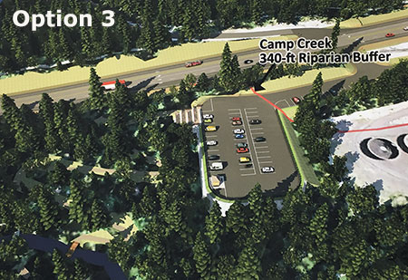
Like the first two options, this version extends significantly into the protected buffer along Camp Creek and would require a fair amount of fill and tree removal. Like the second option, Option 3 makes efficient use of paved areas and the loop design would make for easier plowing and patrolling by law enforcement.

The fourth option is the “preferred” option by FHWA and the Forest Service:

MirrorLake2.11

(click here for a larger map)

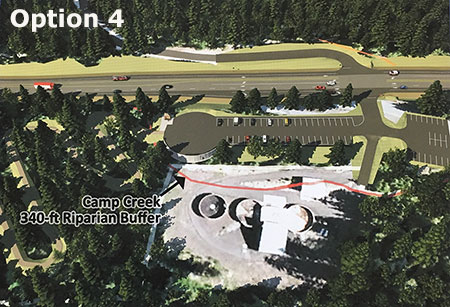
 This option is preferred mostly because it falls outside the protected 340-foot Camp Creek buffer. I walked the site with the Zigzag District Ranger in late 2014, and while it does make sense as the most compact design, it’s also an attempt to squeeze a lot into a very narrow, surprisingly steep strip of land between the treatment plant and highway.

While the mockup illustration (above) for Option 4 shows a few trees left between the parking area and treatment plant, in reality it would be difficult to achieve the amount of fill required to build the new parking area without removing all of the trees along the north edge of the treatment plant. Over time, this could be remedied with new tree plantings along the fill slope, but in the near term, visitors would enjoy a birds-eye view of the open settling ponds and the treatment plant operators may be concerned about this new level of public visibility.

Tree removal is a concern in all of the designs, as this area contains stands of Alaska cedar, a high-elevation cousin of Western red cedar found throughout the Government Camp area, but relatively uncommon in the Cascades.

MirrorLake2.11a

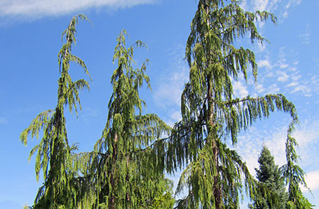
The graceful, drooping form of Alaska Cedar make it a prized commercial landscape tree

All four options feature a very tight turning sequence for drivers arriving from the west, with a right turn into the shared driveway with the Ski Bowl resort, and almost immediately a second right turn into the trailhead parking. These turns create a blind corner for approaching traffic that probably warrants a deceleration lane along the highway — especially given ODOT’s determination to promote high-speed travel along the loop highway.

No Longer Considered…

The FHWA and Forest Service have already dropped some intriguing trailhead locations that I will briefly describe here. For context, the map below shows four of the five sites original sites (those located closest to Government Camp) considered — the four final design options now under consideration are all located at Site 2 on this map:

MirrorLake2.12

(click here for a larger map)

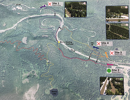
Site 1 is at the end of the Kiwanis Camp Road, which is really an original segment of the Mount Hood Loop Highway:

MirrorLake2.13

(click here for a larger map)

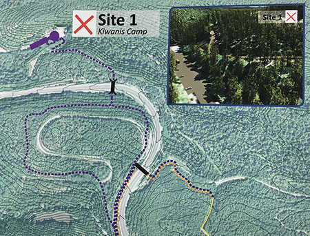
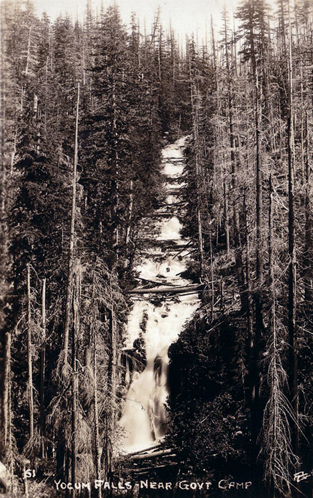
This site already serves as the trailhead for the Little Zigzag Falls trail and a closed section of the old highway leads to the Pioneer Bridle Trail. This site was dropped because of the added distance to reach Mirror Lake and the difficulty in creating a trail crossing over Highway 26 for hikers.

Site 2 is the Ski Bowl location where the previously described design options are still under study:

MirrorLake2.14

(click here for a larger map)

Sites 3 and 4 are located along another portion of the original Mount Hood Highway, opposite Site 2 and the Ski Bowl parking area:

MirrorLake2.15

(click here for a larger map)

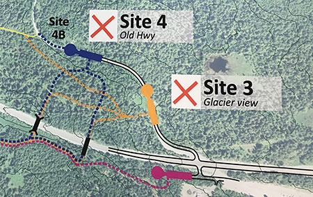
The Glacier View snow park and trailhead is already located along this segment of old highway, and the concept behind both Sites 3 and 4 was to build a larger, shared snow park with a pedestrian bridge over Highway 26 to connect to the Mirror Lake trail. These sites were dropped because of the scale and complexity of spanning Highway 26 with a foot bridge, especially after the highway widening project greatly increased the width of the highway, itself.

Site 5 is located at a quarry at the foot of Laurel Hill, below a prominent rocky knob along the highway created by the road cut (and known as the “Map Curve” to ODOT):

MirrorLake2.16

(click here for a larger map)

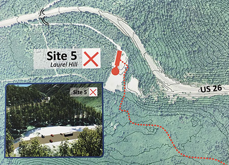
While this site was dropped because of its distance from Mirror Lake, it nevertheless offers exciting opportunities as an alternative trailhead and the potential for a broader strategy to manage the heavy visitation to Mirror Lake. Part 3 of this series will explore the possibility of a larger trail network and more hiking options as a strategy for reducing the pressure on Mirror Lake in the long term.

Tragedy of the Commons?

As disappointing as it may be to lose the historic Mirror Lake trailhead, there are some clear environmental benefits that could be achieved.

First, the new trailhead will about a mile east of the historic trailhead, meaning a longer hike by about two miles, round trip. While this will make the trail less accessible to young families, it’s also true that the lake is showing serious damage from overuse. If the more distant trailhead discourages a few hikers, that could be a win for the lake.

MirrorLake2.17

The Forest Service has done extensive soil stabilization work at Mirror Lake just to keep pace with heavy foot traffic.

As I have argued before on this blog, placing physical barriers to outdoor recreation is tragically short sighted if our goal as a society it to encourage people to be more active and to enjoy and take responsibility for our public lands. Thus, I favor other strategies for addressing heavy use on trails, including peak parking fees at the busiest trailheads.

Eventually, the Mount Hood National Forest will have to adopt a real parking strategy on some of its most heavily used sites, but the agency so far has not acknowledged that reality. Instead, its planners are viewing washed-out bridges (Ramona Falls) and trailhead closures (Mirror Lake) as helpful interventions to tame the masses. That’s a poor solution pretending to be a strategy.

Nonetheless, the Forest Service is clearly a long way from adopting a comprehensive trailhead parking policy at Mount Hood, so for Mirror Lake. Making the hike more difficult is probably the only near-term option if the number of hikers can actually be reduced, however short-sighted the approach.

MirrorLake2.18

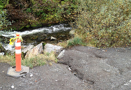
Rill erosion like this is common where Highway 26 abuts Camp Creek, pouring road gravel and pollutants directly into a protected salmon and steelhead stream

Moving the Mirror Lake trailhead could also allow for a meaningful effort by ODOT and the Forest Service to protect Camp Creek from sediment and runoff pollution from Highway 26.

While ODOT is spending tens of millions to carve away solid rock slopes in order to widen the highway, no funds were set aside to improve stream protection for Camp Creek. The creek is home to protected salmon and steelhead, and eventually it flows into the Sandy River — one of the few spawning streams in the Columbia River system with no dams to block fish passage.

MirrorLake2.19

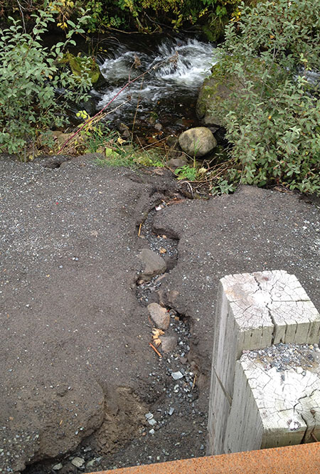
Highway runoff now pours sediment and pollutants directly into Camp Creek at the Mirror Lake trailhead.

MirrorLake2.20

Looking east along Camp Creek (on the right) and Highway 26 showing rill erosion directly from the road surface into the stream

The Forest Service has indicated a commitment to decommission and restore the historic trailhead once the new trailhead has been constructed. That’s a good start, but it’s unclear whether channeling highway runoff away from Camp Creek is part of that plan.

Ideally, ODOT would construct a concrete curb to divert highway runoff for the entire 1-mile highway section that abuts Camp Creek, from the historic trailhead east to the Ski Bowl entrance.

The actual drainage design would more complex, as the amount of runoff here is clearly enough to erode dozens of rills into the shoulder and directly to Camp Creek, as shown in the photos above. But the removal of the Mirror Lake trailhead represents an opportunity for ODOT to show it cares about more than just moving ski traffic at slightly higher speeds.

The agency also has the funds to address highway runoff into Camp Creek as part of the current widening project, as all ODOT projects include hefty contingency set-asides for just this sort of unanticipated expense — as much as one third of the overall project budget is typically “contingency”.

How to Comment

If you love Mirror Lake or care about Camp Creek, it’s worth commenting on the trailhead relocation project, if only because precious few will take the time to do so. The FHWA, ODOT and Forest Service really do take public comments into consideration, especially when it brings new information to their decisions.

MirrorLake2.21

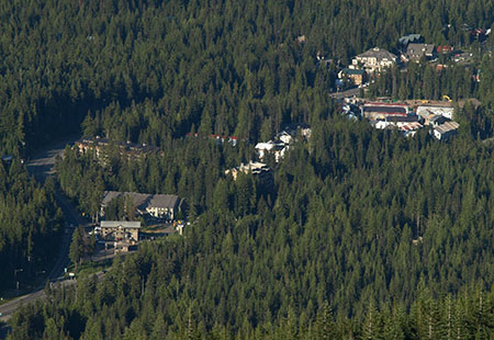
The resort village of Government Camp from above Mirror Lake.

Here are two suggested areas to focus on your comments on:

What would you like to see in the preferred alternative (Option 4)?

Are you frustrated with the winter closure of the existing Mirror Lake trailhead? Be sure to mention this in your comments on the proposed new trailhead, as it will need to be design to be plowed and subsequently added to the Snow Park system to serve as a year-round trailhead.

Consider commenting on other trailhead amenities, as well, such as restrooms, secure bicycle parking, trash cans, drinking fountain, signage, picnic tables, a safe pedestrian crossing on Highway 26 for hikers coming from Government Camp or any other feature you’d like to see.

How would you like to see Camp Creek protected?

The project vaguely proposes to restore the existing shoulder parking area to some sort of natural condition. Consider commenting on how this restoration might work to benefit Camp Creek, which is now heavily affected by highway runoff and the impacts of parking here.

In particular, mention the need to divert highway runoff away from Camp Creek for the entire 1-mile stretch from the old trailhead to the Ski Bowl entrance. The proposed parking area restoration is the perfect opportunity to address the larger need to improve the watershed health.

You can comment to Seth Young at the Federal Highway Administration via e-mail or learn more about the project here:

Mirror Lake Trailhead Project Information:

___________________

 Federal Highway Administration

Seth English-Young, Environmental Specialist

Western Federal Lands Highway Division

610 East Fifth Street

Vancouver, WA 98661-3801

Phone: 360-619-7803

Email: seth.english-young@dot.gov

 ___________________

Subscribe to Project Newsletters

To be added to our mailing list, please send an email to seth.english-young@dot.gov.

 ___________________

For U.S. Forest Service specific questions contact:

Laura Pramuk

Phone: 503-668-1791

Email: lbpramuk@fs.fed.us

___________________

 Thanks for helping guide the future of Mirror Lake!


A New Vision for Mirror Lake (Part 1 of 3)

Summer evening view of Mount Hood from Mirror Lake

Summer evening view of Mount Hood from Mirror Lake

Big changes are coming to the Mirror Lake Trail on Mount Hood, perhaps the single most visited trail on the mountain. This is the first of three articles on the future of Mirror Lake, and the need for a broader vision to guide recreation in the area.
____________

As part of the unfortunate widening of the Mount Hood Highway currently underway west of Government Camp (see this article for more on the subject), the Oregon Department of Transportation (ODOT) has persuaded the U.S. Forest Service to close the existing, historic trailhead for the Mirror Lake Trail.

ODOT claims safety is the chief concern, a point I will visit later in this series. For now, though, it looks like our highway department will close yet another roadside trailhead in a campaign to gradually morph the Mount Hood Highway into full-fledged freeway.

Going back to the beginning…

Just as Mount Hood generally bears the development pressures of being an hour from Portland, and along transportation corridor that dates to the 1840s, Mirror Lake has long carried the burden of being the closest mountain lake to Portland, and the first easily accessible trailhead along the loop highway.

Because of its proximity, the lake shows up on the earliest maps of the Government Camp area, when the Mount Hood Loop Highway had a very rough, early alignment and was not yet a loop. The original Skyline Trail map (below) from the early 1900s shows Mirror Lake just west of the new trail, and a version of the early loop road before the Laurel Hill switchbacks were built.

1920s-era map of Mount Hood and the Government Camp area

1920s-era map of Mount Hood and the Government Camp area

By the early 1920s, the effort to complete the loop highway was in full swing, including the graceful switchbacks that scaled Laurel Hill (below), the spot where Oregon Trail immigrants had to lower their wagons with ropes because of the steepness of the terrain. Surprisingly, a formal trail to Mirror Lake had not yet been constructed by this time.

1920s map of the first paved alignment of the Mount Hood Loop Highway at Government Camp

1920s map of the first paved alignment of the Mount Hood Loop Highway at Government Camp

Other maps from the early 1900s (below) tell another story about Mirror Lake: it was within the northern extent of the Sherar Burn, a massive fire that had destroyed forests from the Salmon River to Camp Creek. As recently as the 1980s, bleached snags from the fire were standing throughout the Mirror Lake area.

1920s map showing the Sherar Burn extent in the Mirror Lake area

1920s map showing the Sherar Burn extent in the Mirror Lake area

The Sherar Burn of the mid-1800s created vast tracts of huckleberries across the area, and during the early days of the highway, huckleberry pickers were a common sight, selling coffee cans of fresh berries to mountain visitors (below).

Huckleberry pickers in the 1930s at the Little Zigzag River bridge, below Laurel Hill

Huckleberry pickers in the 1930s at the Little Zigzag River bridge, below Laurel Hill

Mirror Lake, itself, looked quite different in the 1920s, too. Today’s tree-rimmed lake was mostly surrounded by burned snags and fields of beargrass and huckleberry in the 1920s (below).

Mirror Lake in the late 1920s

Mirror Lake in the late 1920s

Sometime in the late 1920s or early 1930s, a new trail was constructed from the new highway to Mirror Lake. The trail began at a sharp turn on the old highway, traversing above the north shoulder of Yocum Falls on Camp Creek, crossing to the south side of the creek at the spot where the modern trailhead is located today (see maps below).

This lower section (from the bend in the old highway to the modern trailhead) of the original Mirror Lake trail was destroyed just 25 years later, when the modern highway grade cut through the area. This portion of the old highway still exists in this area, accessible from the Laurel Hill historic landmark pullout (currently closed because of the highway widening).

1930s map of the original Mirror Lake Trail

1930s map of the original Mirror Lake Trail

1930s map of the Mirror Lake Trail and surrounding area

1930s map of the Mirror Lake Trail and surrounding area

When the original Mirror Lake Trail was built, the trailhead was located just a few yards beyond an impressive roadside viewpoint of Yocum Falls on Camp Creek (below). Today, the forest has recovered so completely in this part of the Sherar Burn that this viewpoint is completely overgrown. It is still possible to visit Yocum Falls from the old highway grade, though, by following rough use trails.

Yocum Falls as it once appeared from the original Mount Hood Loop Highway

Yocum Falls as it once appeared from the original Mount Hood Loop Highway

The lower section of the original trail seems to have followed the rambling extent of Yocum Falls quite closely before the trail was destroyed by the modern highway. While the current trailhead gives a brief glimpse of the top of the falls, the old route seems to have provided a nice view of the falls since lost (more on this topic in the third part in this series).

Today, the modern Mirror Lake trailhead continues to provide a popular drop-in hike for families and casual hikers, but the convenience comes at a price. The shoulder parking area is large enough to allow up to 100 cars, and on busy weekends, still more hikers park along the highway all the way to Government Camp, walking the highway shoulder to reach the trailhead.

The Mirror Lake Trail was never designed to handle this much traffic, nor is the small lake able to handle so many visitors. These concerns are part of the Forest Service thinking in why a new trailhead should be constructed.

Camp Creek suffers from its close, unprotected proximity to Highway 26 and the Mirror Lake Trail parking.

Camp Creek suffers from its close, unprotected proximity to Highway 26 and the Mirror Lake Trail parking.

Meanwhile, the 1950s-era trailhead pullout in use today was built at a time when little thought was given to environmental impacts. As a result, highway fill was pushed to the edge of Camp Creek, exposing an important salmon and steelhead stream to heavy loads of silt and pollution from parked vehicles. A visit to Yocum Falls, just downstream, reveals a troubling amount of road debris and the sharp odor of pollution in an otherwise healthy stream corridor.

While these growing impacts on Mirror Lake and Camp Creek aren’t the reason ODOT gives for closing the current Mirror Lake Trailhead, they are compelling arguments to consider.
____________

The next part of this 3-part series will take a closer look at ODOT’s arguments for closing the existing trailhead and the Forest Service proposal for a new trailhead located east of the existing access.

Highway 26 Widening Postscript… and Requiem?

Original Loop Highway section on Laurel Hill in the 1920s, later destroyed when the present highway was built in the 1960s

As a postscript to the previous two-part article, I offer some final thoughts on the proposed widening of the Mount Hood Highway in the Laurel Hill area:

First, the Oregon Department of Transportation (ODOT) process used to gather public input on projects like those proposed for Laurel Hill is abysmal. Information on the web is cryptic, at best, and generally absent. Amazingly, there is no opportunity to comment online, nor information on how or where to comment. When I contacted project managers about making comments, I was given different comment deadlines, a full month apart. The ODOT website contains no information on comment deadlines.

ODOT posts a “users guide” to the State Transportation Improvement Program (STIP) process used for funding decisions, but this document manages to be more cryptic than the draft STIP document, itself, since it has been written for government workers and program insiders, not citizens. The process is also designed to buffer the Oregon Transportation Commission from public comment, with any input that does make it to the ODOT region offices collected and processed in a way that effectively buries public concerns under official recommendations by ODOT managers and obscure “citizen” commissions called ACTs. Since there is no ACT for the Mount Hood area, the comment opportunities for the Laurel Hill proposals fall into an even murkier void. In the end, this is a process that is staff-driven, and out of step with the ethic of citizen-centered transportation planning.

Second, the STIP selection process is a done deal by the time most citizens see it, since projects emerge from within the ODOT bureaucracy, not through an open solicitation of public ideas and needs, or even a long-range plan that maps out a pool of projects to draw from.

Thus, the projects in the Laurel Hill area will be very difficult to stop, since they surfaced in the past STIP cycle, and are now about to be funded in 2010 and 2011 as a “routine” final step. Since citizens are discouraged from participation in the selection phase of project funding, these projects will likely advance to a design and construction phase that makes them inevitable before any real public outreach or discourse can really occur. This was the case in the previous “widening for safety” projects in the Wildwood area, where the broader public outreach to citizens in the adjacent corridor began long after the project was conceived and funded. This left area residents with a Hobson’s choice between various widening options for “safety” as opposed to real choices for improving safety that could have been less costly and destructive.

Loop highway construction in the Brightwood area in the 1930s

Third, it is time for the Oregon Transportation Commission to pull the plug on the notion of “widening for safety”. This is a dubious loophole in the funding process the OTC sets forth for project selection, where safety benefits generally bring projects to the top of the list.

That’s a laudable goal, but it allows widening projects cloaked under the “safety” mantle to advance, unquestioned, and become the first to be funded. But as the Wildwood project details admitted, these projects are mostly about “matching the cross-section” of previously widened highway sections in the vicinity, not safety. So, this is nothing more than an highway capacity agenda, and it should be openly considered as such, not slipped under the radar of the OTC.

The stakes are much higher for the Laurel Hill “widening for safety” projects. While future generations may choose to tear up the asphalt and replant the forests that were cut away to make room for a wider highway in the Wildwood and Rhododendron sections, the Laurel Hill projects will require ODOT to blast away more of Laurel Hill’s rocky face. These changes are permanent and destructive, and it would take centuries for the area to recover, should our children or grandchildren conclude that we made a grave error in judgement in an our efforts to save skiers a few minutes driving time. The decision ought to be considered carefully in this light, not slipped through without public discussion.

Simpler days: the original loop highway corkscrewed up Laurel Hill, molding to the terrain as it climbed the steep slopes made infamous by Oregon pioneers

It is also true that ODOT has the means for a very open discussion about the projects proposed on Highway 26, and could give the OTC a true sense of public support for these proposals. For example, ODOT could simply post signs along the highway advertising the projects, and direct interested citizens to an online opportunity to comment. The agency could even use the giant electronic message sign in Rhododendron for this purpose, if meaningful public involvement were truly the objective.

I submit these critiques as one who works in the transportation planning realm daily, so it is both frustrating and discouraging to imagine what an ordinary citizen would have to overcome to be heard in this process. It is a fact that transportation planning is an arcane and difficult to understand realm, and for this reason, Federal Highway Administration (FHWA) regulators are looking for more meaningful public involvement in transportation decisions at the state and local levels. The ODOT processes fall far short of what the FHWA envisions, where ordinary citizens could easily access information about projects that affect them, and make meaningful comment to decision makers.

To meet its regulatory expectations from the federal government, and its obligation to Oregon citizens who fund the very existence of ODOT, it is time for the agency to engage the public in a more meaningful way, and allow each of us to weigh in on how our tax dollars will be spent. The looming decisions about the Mount Hood Highway would be a good starting point for this needed reform.
_________________________________________

Download a copy of the Mount Hood National Park Campaign (PDF) comments on the Highway 26 projects: click here

Download a slide presentation of the 2009 safety audit (PDF) of the Laurel Hill section of Highway 26: click here

Highway 26 Widening Projects – Part Two

The Oregon Department of Transportation (ODOT) is set to begin construction of more than $27 million in road widening projects along the Mount Hood Highway in 2010 and 2011. These projects are supposed to improve safety along the segment of Highway 26 located east of Rhododendron, and along the Laurel Hill grade. In reality, they will do little more than speed up traffic, and perhaps even make the highway less safe as a result.

There are a total of three projects proposed for the Mount Hood corridor in this round of funding, including two “safety” projects that would widen the highway, and a third “operations” project that appears to be driven by the other two “widening for safety” proposals. The projects and their ODOT key numbers are shown on the map below.

Three projects are proposed for Highway 26 in 2010-11 that will add capacity to the road, though only if you read the fine print

(click here for a larger map)

The most alarming of the projects in this round of road widening is a proposed downhill passing lane on Laurel Hill, supposedly making it “safer” for throngs of Portland-bound skiers to pass slow vehicles on the downhill grade on busy weekends. This project is a repeat of the outmoded “widening for safety” philosophy that has already impacted the lower sections of the corridor, and was described in Part One of this article.

The ODOT project details for the “downhill passing lane” are sketchy, but such projects generally assume that drivers forced to follow slow vehicles become frustrated, and attempt to pass in an unsafe manner — a potentially deadly decision on a winding, steep mountain road. But is the answer to build a wider, faster road? Or should ODOT first use all of the other tools available to manage the brief periods of peak ski traffic before spending millions to cut a wider road into the side of Laurel Hill?

The answer to these questions seem obvious, but in fact, ODOT is moving forward with the most expensive, environmentally destructive options first, in the name of safety.

The westward view of the Laurel Hill Grade in a section proposed for widening to allow a downhill passing lane. The newly protected wilderness of the Camp Creek valley spreads out to the left.

A better solution, at least in the interim, would be to employ some of the less-expensive, less environmentally degrading approaches that have been successfully used elsewhere in the corridor. One option could be simply enforcing the current 55 mph speed limit and no-passing zones, for example, which would be much more affordable than the millions proposed to widen the highway in this difficult terrain.

Another possibility could be to extend — and enforce — the 45 mph safety corridor speed limit east from Rhododendron to the Timberline Junction, in Government Camp. Enforcing this slower 45 mph limit would result in skiers spending only an additional 90 seconds traveling the nine-mile section of Highway 26 from Government Camp to Rhododendron. This would seem a reasonable trade-off in the name of safety, especially compared to the millions it would cost to build downhill passing lanes on this mountainous section of highway.

The view east (in the opposite direction of the previous photo) where road widening is proposed to add a fourth downhill lane, carved from the sheer side of Laurel Hill.

Delaying the current road-widening proposals and taking a less costly approach to improving safety would also allow ODOT to more fully evaluate the effects that growing traffic on Highway 26 is having on the surrounding area. And while it is true that delaying a project that has already moved this far in the ODOT funding pipeline is an uphill battle, it is also true that a more fiscally conservative approach is clearly more consistent with the agency’s own transportation policy than the costly widening projects that are proposed.

However, while the visionary Oregon Transportation Plan (OTP) calls for a departure from old school thinking when it comes to new highway capacity, it does not establish a detailed vision for the Mount Hood Highway. But the general direction provided by the OTP does support a least-cost approach to managing highways, and slowing down the latest road widening proposals in the Mount Hood corridor would be consistent with that policy.

Unfortunately, the badly outdated Oregon Highway Plan (OHP) sets the wrong direction for the Mount Hood Highway, emphasizing speed and road capacity over all else. But until a better vision is in place for the highway, the response by ODOT planners and engineers to safety concerns and traffic accidents in this corridor will be more road widening projects sold as “safety improvements.”

Both the Salmon-Huckleberry and Mount Hood wilderness areas saw major expansions in 2009 that were not considered in the proposed ODOT expansion projects for Highway 26

(click here for a larger map)

Over the years, this old-school approach has already created a road that is rapidly approaching a full-blown freeway in size and noise impacts on surrounding public lands. At the same time, the pressure to minimize highways impacts on the forest surroundings is still growing.

In 2009, wilderness areas around Mount Hood were significantly expanded, and the new boundaries now draw close to the highway along the Laurel Hill grade, where the “safety” widening is proposed. What will the noise impacts of the proposed highway expansion be on the new wilderness?

Already, highway noise dominates the popular Tom Dick and Harry Mountain trail inside the new wilderness, for example, more than a mile to the south and 1,500 feet above the Laurel Hill Grade. How much more noise is acceptable? How will hikers destined for these trails safely use roadside trailheads to access wilderness areas?

Nearby Camp Creek should be a pristine mountain stream, but instead carries trash and tires from the Mount Hood Highway. While it is protected by wilderness now, how will storm water runoff from an even wider highway be mitigated to avoid further degradation? How will existing pollution impacts be addressed?

The answers to these questions were not considered when this new round of “widening for safety” projects were proposed, but should be addressed before projects of this scale move to construction.

This view west along the Laurel Hill Grade shows the proximity of the new Mirror Lake wilderness additions to the highway project area.

This view east along the Laurel Hill Grade, toward Mount Hood, shows the proximity of the new wilderness boundary to the project area.

In the long term, the solution to balancing highway travel needs with protection of the natural resources and local communities along the Mount Hood corridor needs a more visionary plan to better guide ODOT decisions. Such a plan could establish an alternative vision for the Mount Hood Highway that truly stands the test of time, where the highway, itself, becomes a physical asset treasured by those who live and recreate on the mountain. This should be the core principle of the new vision.

The very complexities and competing demands of the Mount Hood corridor make it a perfect pilot for such a plan — one that would help forge a new framework for managing the highway in a sustainable way that protects both community and environmental resources.

There is also room for optimism that ODOT can achieve a more visionary direction for the corridor. The agency is showing increasing sensitivity to the way in which transportation projects affect their surroundings, as evidenced by in recent projects in the Columbia Gorge and even on Mount Hood.

To underscore this point, I chose the logo at the top of this article because it shows a re-emerging side of ODOT that understands both the historic legacy and the need for a new vision for the Mount Hood Highway that keeps the road scenic and special. After all, Oregon’s highway tradition that includes the legacy of the Historic Columbia River Highway, the Oregon Coast Highway and the amazing state park and wayside system was largely developed as an extension of our early highways. ODOT can do this simply be reclaiming what is already the agency’s pioneering legacy..

The Laurel Hill Grade on Highway 26 as viewed from a popular trail in the new Mirror Lake additions to the Salmon Huckleberry Wilderness.

The missing piece is direction from the Oregon Transportation Commission (OTC) to develop a new vision that governs how the highway is managed, and establishes desired community and environmental outcomes by which highway decisions are measured. But until a new vision for the Mount Hood Highway is in place, it makes sense to slow down the current slate of costly projects that threaten to permanently scar the landscape, and take the necessary time to develop a better plan.

If you care about the Mount Hood Highway, you should make your thoughts known on both points, and the sooner the better. The process used by ODOT to make these decisions is difficult for citizens to understand and track, especially online. So, the easiest option for weighing in is to simply send your comments in the form of an e-mail to all three tiers in the decision-making structure, using the contact information that follows.

Comments to ODOT are due by January 31, but you also can comment to the Clackamas County Commission and OTC at the same time. Contact information can be found on these links:

ODOT Region 1
(Select one of the Region 1 coordinators listed)

Clackamas County Commission

Oregon Transportation Commission (OTC)

When describing the projects, you should use the “key numbers” shown in the first map, above, as well as the project names. Simply state your concerns in your own words, but consider these critical points:

  1. The proposed Mount Hood Highway widening projects should be delayed until less-expensive, less irreversible solutions can be explored;
  2. The Mount Hood Highway needs a new vision and a better plan

Remember, these are your tax dollars being spent and your public lands at stake. You have a right to be heard, and for your voice to have an impact. With any luck, these projects can be delayed, and more enlightened approaches explored for managing our highway.