Author’s note: I wrote a version of this article for the Mazama newsletter a few weeks ago, so I’m sharing an expanded version here, as this is a sequel to a WyEast Blog post from 2011.
_________________
Since posting an article more than a decade ago (“Return of the Mountain Goat”) proposing reintroduction of Rocky Mountain Goats on Mount Hood, I’ve received a steady stream of updates from area hikers with recent goat sightings on Mount Hood and in the Columbia River Gorge. Are they making a spontaneous comeback?
Possibly. But I couldn’t have predicted the many related events that have unfolded since I wrote that first piece back in 2011, and they don’t necessarily help the case for bringing mountain goats back to Mount Hood – nor do they rule the idea out. It’s just much less clear, now.
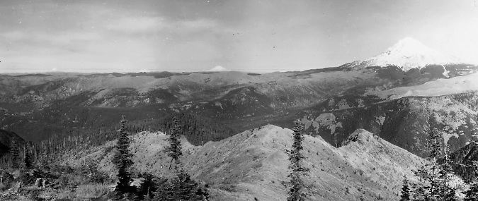
The first big event was the Dollar Lake Fire on Mount Hood that roared through just a few months after I posted the article. While there had been fairly recent fires on the east slopes of the mountain (the Bluegrass Fire and Gnarl Fire), they had mostly burned below timberline and were also partly within the ecological zone known as “fire forests”. These are forests with fire-dependent species like Ponderosa Pine and Western Larch have evolved with fire as a regular occurrence on the dry east slopes of the mountain.
Dollar Lake Fire burning across Mount Hood’s north side in September 2011
The Dollar Lake Fire on the north side was different, largely burning subalpine Noble Fir and Mountain Hemlock forests, species that have not evolved to withstand fire. The result was a complete canopy loss along most of the north slope of the mountain. I’ve since been documenting the forest recovery in a series of WyEast blog articles, and it’s a story of remarkable resilience in an ecosystem where fires are both rare and devastating.
However, if you were a mountain goat living on Mount Hood when that fire roared through in the late summer of 2011, you would likely have survived. Though the Dollar Lake Fire touched timberline in places like Elk Cove and Cairn Basin, most of the timberline and alpine habitat was untouched. This would have allowed goats living in the rocky areas at and above the tree line to escape the smoke and flames during the event.
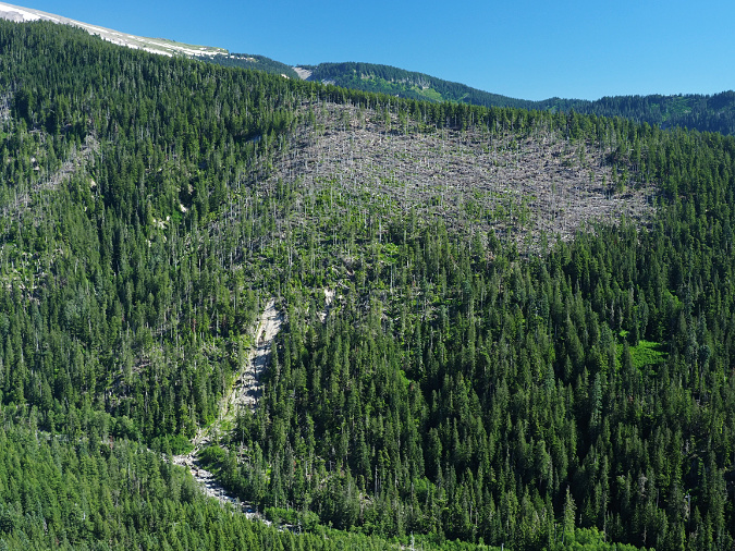
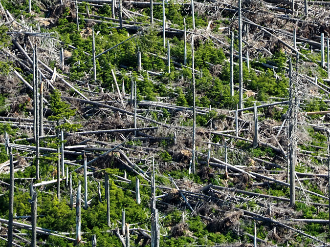
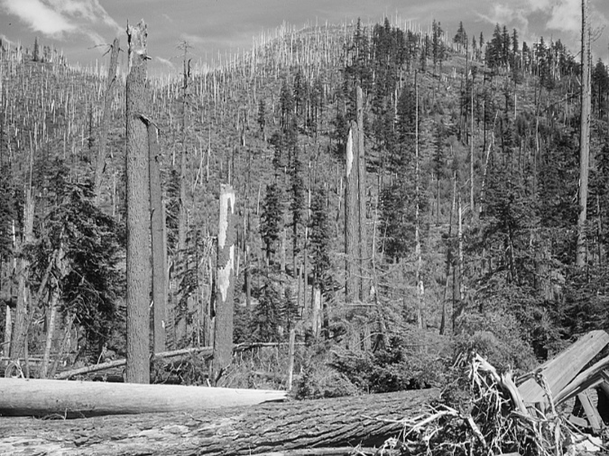
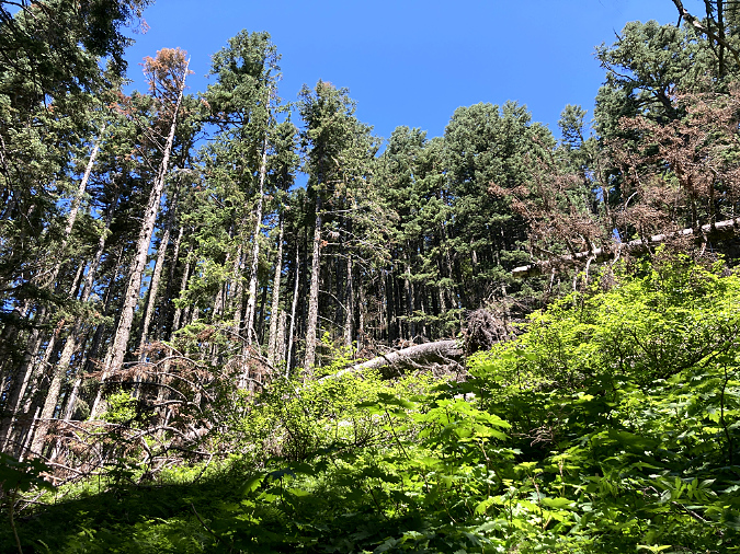
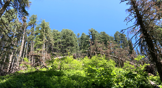
The Dollar Lake Fire transformed more than 6,000 acres of subalpine terrain from dense forests to open huckleberry and beargrass fields. This scene is from 99 Ridge, above Elk Cove
The vast huckleberry and beargrass fields that now grow among bleached tree skeletons within the burn zone are prime habitat for wildlife, including elk, deer and bear. What is unknown is whether the new habitat would support mountain goats where it exposed rocky terrain that had been engulfed in forest cover over the past century – places like The Pinnacle or 99 Ridge (the rocky ridge that forms the west wall of Elk Cove, shown above).
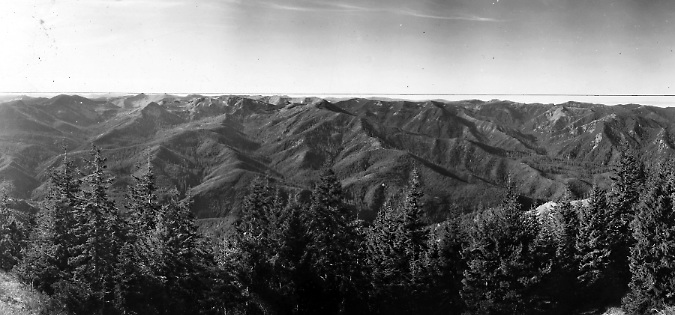
We do know that when white migrants began streaming into the Oregon country in the mid-1800s, the Cascade forests looked much different than they do today, after a century of wildfire suppression. A series of survey photos captured from dozens of Forest Service lookouts in the early 1930s provide a remarkable record of just how open much of the high country surrounding Mount Hood was in places like Zigzag Mountain, Mirror Lake and today’s Salmon-Huckleberry Wilderness.
The northern slopes of Devils Peaks had been cleared by repeated fires over centuries in this 1933 lookout panorama. In the distance, the entirety of Zigzag Mountain was also an open expanse of huckleberry and beargrass fields. Mount Hood and the burned slopes near Mirror Lake are on the right
These openings were created by repeated fires, some set by indigenous people who had used fire for centuries to maintain ridgetop fields of beargrass and huckleberries for food and medicinal purposes. Thin mountaintop soils and summer lightning strikes during our summer droughts combined to make these forests vulnerable to wildfire, as well – and still do.
The view across the Salmon Huckleberry Wilderness in 1933 shows most of the peaks and ridgetops now covered by timber to still open from centuries of repeated fires
This 1932 view from Hickman Butte, in the Bull Run watershed, shows signs of recent fires in the foreground and on Sugarloaf Mountain (in front of Mount Hood), as well as the open northern slopes of Zigzag Mountain in the distance (and to the right of Mount Hood) created by fires
In September 2017 we watched the Eagle Creek Fire burn through the Oregon side of the Columbia River Gorge. This was the first major fire in the Gorge in more than a century, burning much of the high country in the Hatfield Wilderness, as well as the steep, drought-prone cliffs of the Gorge walls. Thanks to the east winds that define the Gorge, we know that especially devastating fires were once common here, as shown in both the 1930s lookout surveys and in vintage late-1800s photographs by Carleton Watkins, the Kiser Brothers (below) and Benjamin A. Gifford.
The cliffs above today’s Warrendale community and McCord Creek canyon in the Columbia Gorge were mostly open when this photo was taken by the Kiser Brothers in 1903. The Eagle Creek fire of 2017 has returned this area to a similar post-fire habitat
Their early images show the rugged cliff walls and high ridges of the Gorge as we see them today, covered with lush, recovering understory that we know has been a boon to deer and elk populations. By comparison to the Mount Hood fires, the 2017 burn area in the Gorge opened much more steep, rocky terrain that could be favorable to goats.
When the 2020 wildfires swept through Oregon, one of the impacted areas was Mount Jefferson, where mountain goats had been transplanted in 2010 in a collaborative effort by the Oregon Department of Fish and Wildlife (ODFW) and Confederated Tribes of Warm Springs (described here in the original 2011 post). State wildlife managers expressed concern over the fate of the goats at the time, given the scale of the fires.
Regrowth already beginning a few weeks after the Lionhead Fire in 2020 (USFS)
Like the Mount Hood fires, the 2020 fires around Mount Jefferson opened rocky terrain that had become heavily forested over the past century through human-fire suppression, though at Mount Jefferson the amount of burned alpine terrain is much more extensive in places like Park Ridge. We may eventually discover that these fires allow reintroduced mountain goats in this area to expand their range to burned places like the upper Breitenbush basin and even the Bull of the Woods wilderness.
Another unexpected development since the 2011 blog article was a National Park Service (NPS) decision to relocate hundreds of mountain goats from Olympic National Park to the North Cascades, in Washington State. This came as a shock to many, given the perceived iconic connection of goats to the Olympics, but the controversial plan was well conceived and deeply grounded in science when it swung into motion in 2018.
Park Service staff transporting goats at Olympic National Park in2018 (NPS)
Less known to the public at the time was that Rocky Mountain Goats were not native to the Olympics, and instead had been introduced by hunters in the 1920s. The combination of their environmental impact and (sometimes fatal) interactions with park visitors finally led to the NPS plan to eliminate the herds from the park.
By the summer of 2020, the Park Service had removed 381 goats from the park, with 325 of these relocated to the North Cascades. Most of the rest did not survive the capture or transport process, and 16 kids were transferred to area zoos. Some goats were left behind because of the difficulty of capture, and the Park Service scientists believe the number too small to regenerate a population.
The more jarring news is that most of the 324 relocated goats have not survived. The Park Service reported earlier this year that of the 151 goats among the transplanted population that were equipped with tracking collars, only four are now known to be alive. According to the scientists, the die-off is not simply a result of the relocation, but likely due to lack of suitable habitat – and especially climate change, which has resulted in summer drought and lack of forage for goats in the North Cascades.
Park Service staff transporting goats in 2018 (NPS)
We are in a period of rapid change for so many species, and our mountain goats can be added to that list. The Park Service estimates that 10,000 goats were living in the Washington Cascades as recently at 60 years ago, a number that has dropped to just 3,000 today.
What does this mean for bringing goats back to the northern Oregon Cascades? I remain optimistic that the return of wildfire to our high-country landscapes will create enough alpine and subalpine habitat for these animals to once again thrive here – that we will once again see Rocky Mountain goats where they had always been, on the snowy slopes of Mount Hood and along the rocky cliffs and ridgelines of the Columbia Gorge.
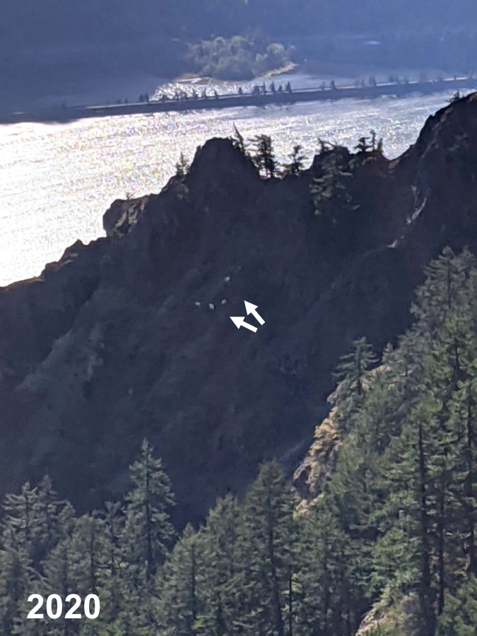
Indeed, in recent years, there have been periodic sightings of lone goats on Mount Hood on the east slopes of the mountain, near the Newton Clark glacier, and on the west side, high on Yocum Ridge. One recent sighting made local news this summer when a hiker on Yocum Ridge captured a video clip that has since circulated widely (below).
Lone mountain goat spotted on Yocum Ridge earlier this year (KOIN-TV)
These recently spotted goats on Mount Hood almost certainly migrated from the herd that was transplanted to Mount Jefferson in 2010. The long trip north to Mount Hood would have required at least 40 miles of travel along a relatively low, mostly forested section of the Cascade Crest, crossing Highway 26 and perhaps Highway 35 along the way. These obstacles underscore just how adaptative these animals can be when searching for new habitat.
Hikers have also spotted mountain goats on the north side of the Columbia River Gorge in recent years, mostly near Dog Mountain. While there are several goat herds to the north of the Gorge in Washington State, in the Gifford Pinchot National Forest, these are the first recent sightings within the Gorge, suggesting the Washington herds are expanding their range southward.
Lone mountain goat near Carson in the Columbia Gorge (Oregon Hikers)
Herd of four mountain goats on Dog Mountain (Oregon Hikers)
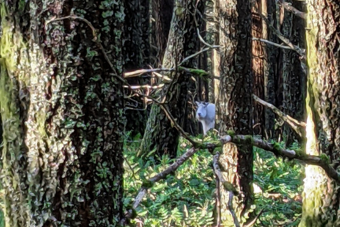
Hikers have also spotted the ghost-like appearance of a mountain goat grazing in a heavily forested area near Dog Mountain (below). This sighting confirms their ability to travel between their preferred higher-elevation terrain in search of new habitat, as would be the case for Washington herds migrating south through forests to the reach open cliffs of the Gorge.
Ghost in the forest spotted near Dog Mountain in 2020 (Oregon Hikers)
Recent goat sightings like these in the Gorge and on Mount Hood are a thrill, and they have made for a lot of excitement in the hiking community. Do they represent a trend and perhaps the return of this species to its historic range in WyEast Country?
Only time will tell, but it’s a hopeful glimpse of what may come!
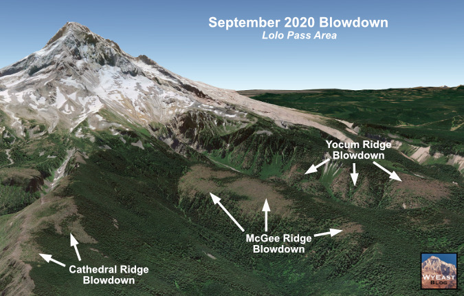
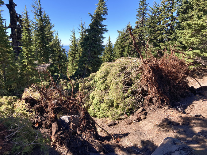
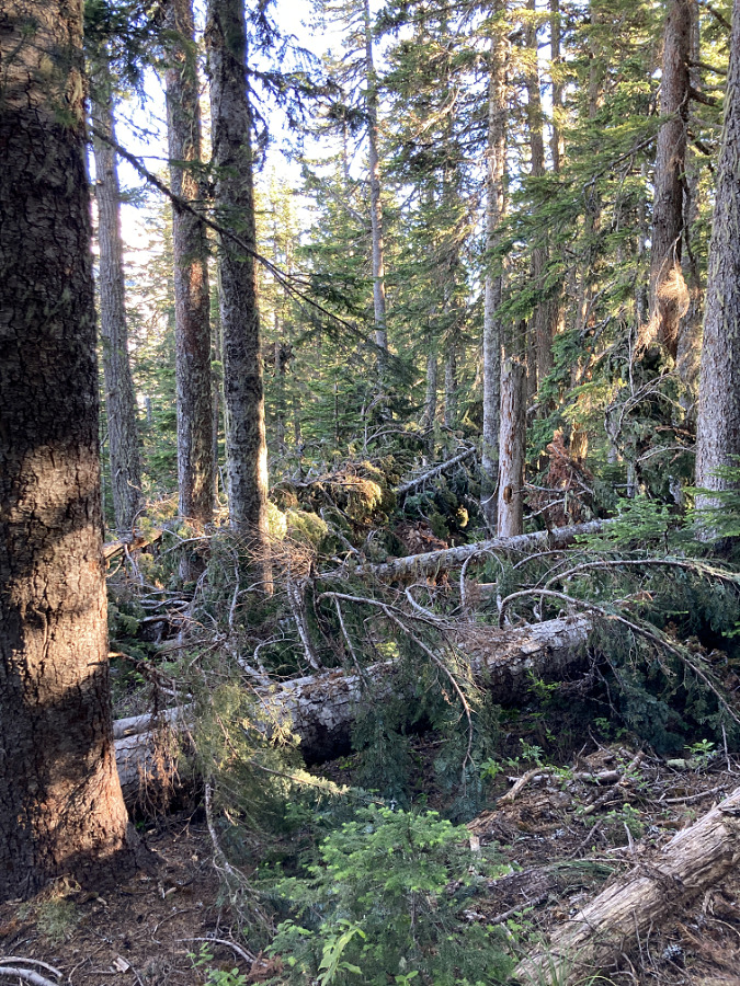
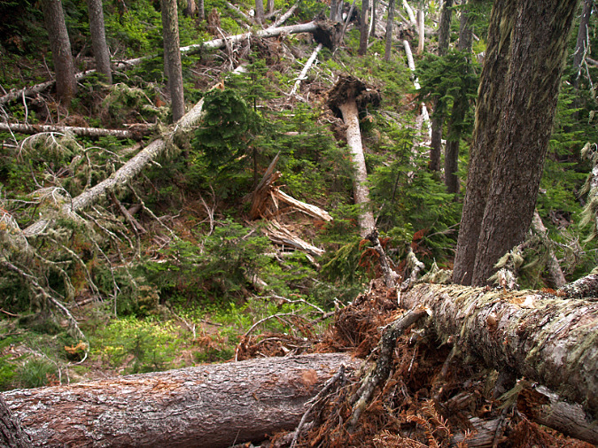
Blowdown from the 2020 wind storm on Mount Hood’s McGee Ridge
The spectacle and impact of the massive forest fires that exploded in the northern Oregon Cascades in September 2020 overshadowed widespread blowdown events that might otherwise have made headlines at the time. The two were linked, with a strong east-west atmospheric pressure gradient producing gale-force winds along the Cascade Crest during the driest month of our annual summer drought.
Like the recent forest fires in the Gorge, on Mount Hood and the Riverside Fire that swept much of the Clackamas River watershed, many of the recent blowdowns on Mount Hood are in plain sight and have since added to the public anxiety over the future of Mount Hood’s forests.
On Mount Hood’s slopes there were large areas of blowdown from this event along Cathedral Ridge, McGee Ridge and Yocum Ridge, with smaller blowdown patches scattered along other ridges around the mountain and on smaller peaks along the Cascade Crest. One of the more prominent blowdown areas on the shoulder of McGee Ridge is prominently visible from Lolo Pass (shown in the opening photo and below).
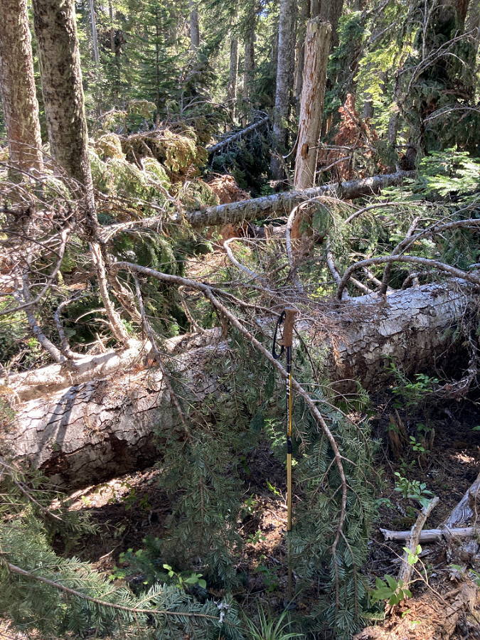
Closer view of blowdown on McGee Ridge
Detailed view of blowdown on McGee Ridge
The visual impact of whole forest stands being toppled like matchsticks is jarring enough, but in the case of the Yocum Ridge blowdown, an entire section of the Timberline Trail was also impacted.
While these events seem new and troubling, blowdowns — like wildfires – are endemic to our forest ecosystem. As such, blowdowns have emerged in recent years as a topic of increased interest to forest scientists. This article draws from the changing understanding of extreme wind events as a normal, mostly beneficial contributor to forest health in WyEast Country, complementing natural forest fires in surprising ways.
Recent Events on Mount Hood
The recent blowdown events on Mount Hood are hard to miss for those who spend time on the many trails that encircle the mountain. Most occurred during the September 2020 event, but there were earlier events on a smaller scale that point to blowdowns as a regular, ongoing force shaping our forests.
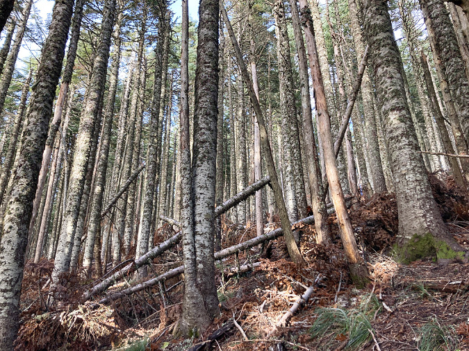
The 2020 event brought down whole forests on Mount Hood’s northwest slopes (below), leaving a tangle of fallen trees in their wake. Most trees were snapped off or tipped, with with their root ball on end and their tops pointing in the direction of the prevailing wind force. While a few trees within the blowdown areas managed to remain standing, they were stripped bare of limbs and foliage, and few eventually survived the destructive impact of the event.
The September 2020 windstorm created large areas of blowdown on the forested ridges that radiate from Mount Hood
Less obvious from a distance are the thousands of trees that fell within the still-standing forests that border the blowdown areas. Outside the major blowdown areas, there were many scenes like those shown below on ridges and steep slopes around the mountain.
Though this forest on Bald Mountain was largely spared, many small trees within the canopy were still toppled in the September 2020 wind storm
The September 2020 wind event had the effect of thinning this young forest near Lolo Pass by toppling small, struggling trees within the canopy
Meanwhile, the 2020 storm also toppled hundreds of timberline trees on the south side of the mountain. Most of these were thick-trunked, ancient Mountain Hemlock, and they were simply tipped, roots and all, by the high winds. The south side blowdown was less extensive, however, with scattered trees tipped in a seemingly random fashion (below).
Ancient Mountain Hemlocks near Timberline Lodge were toppled during the 2020 wind storm
Upturned roots of toppled Mountain Hemlock above Zigzg Canyon on Mount Hood
Localized blowdown from the 2020 wind storm in a Mount Hemlock forest above Zigzag Canyon
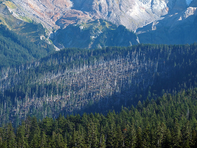
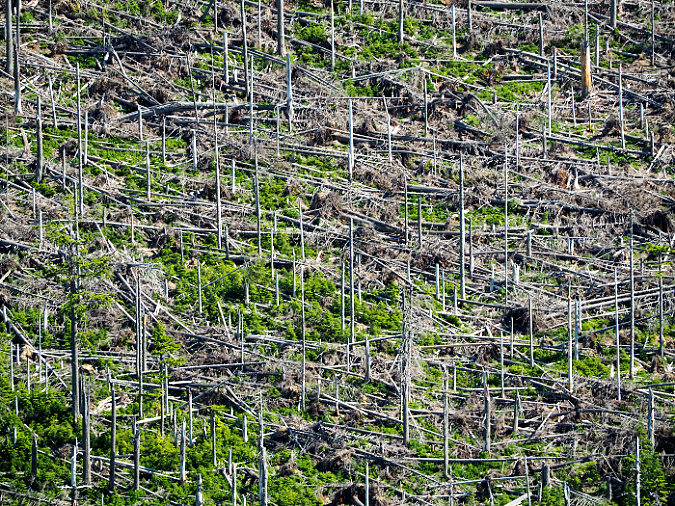
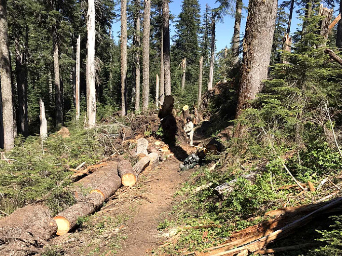
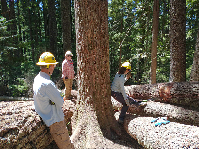
The blowdown on Yocum Ridge was the most widespread and complete, leveling several hundred acres of Noble fir and other mountain conifers (below). The effects here were immediate for hikers, as scores of ancient Noble Fir fell across the Timberline Trail between Ramona Falls and the Muddy Fork crossing. These piles of old-growth logs took volunteer crews hundreds of hours to chip away with handsaws, as this area is within the Mount Hood Wilderness, where motorized equipment is prohibited.
This large blowdown area from the 2020 wind storm is on the north slope of Yocum Ridge
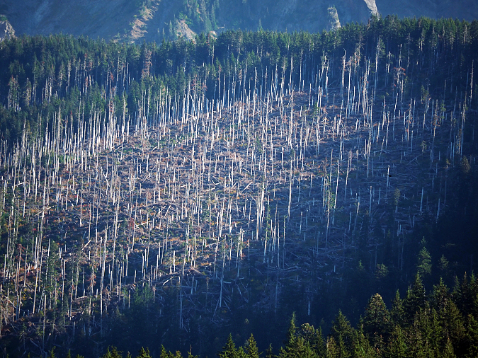
Closer view of the Yocum Ridge blowdown area showing alignment of downed trees that reveals the wind direction during the storm
Detailed view of the Yocum Ridge blowdown area showing the dense understory of young Noble Fir that have already begun replacing this downed forest
The blowdown on Yocum Ridge in 2020 covered the Timberline Trail with large, old-growth logs for nearly two miles (photo: Trailkeepers of Oregon)
Trail volunteers beginning the work of clearing blowdown below Yocum Ridge (photo: Trailkeepers of Oregon)
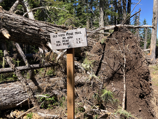
At the north end of the Mount Hood Wilderness, the 2020 wind event toppled hundreds of trees along the Old Vista Ridge trail, especially in the low, wind-exposed saddle that divides the West Fork and Clear Fork drainages (below). Like the south and west side blowdown areas, some trees were simply snapped off, but most were tipped, pulling their roots from the thin mountain soils that are typical along Mount Hood’s ridges and subalpine slopes.
This pair of 150-year-old trees were tipped during the 2020 wind storm, and somehow left the Old Vista Ridge trailhead sign intact
Blowdown from the 2020 wind storm along Mount Hood’s Old Vista Ridge Trail
Blowdown from the 2020 wind storm along the Old Vista Ridge Trail
Volunteers from Trailkeepers of Oregon (TKO) eventually cleared the Old Vista Ridge trail in 2021, though some sections had to be re-routed where the entire tread was pulled up or covered by upturned root balls. Among the other poplar trails on Mount Hood affected by the 2020 blowdown were Elk Cove, Vista Ridge, Cathedral Ridge, Bald Mountain, Yocum Ridge, Hidden Lake and Paradise Park.
Natural Forest Blowdown vs. Logging Blowdown
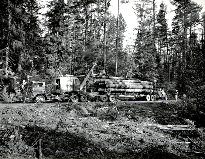
For many years during the logging heyday that extended from the 1950s into the 1990s on our public lands, blowdown was a growing concern that highlighted the many ecological problems with clear-cutting our forests. This was especially true in high-elevation forests, where you can still find piles of fallen trees in the intact forests that border clearcut areas, such as the scenes below on the shoulder of Lookout Mountain, just east of Mount Hood. This clearcut at Horkelia Meadow dates to the 1990s, yet the resulting blowdown impact on the adjacent forest continues today.
Blowdown near Horkelia Meadow resulting from a 1990s clearcut that exposed the remaining forest to new wind loads
Blowdown near Horkelia Meadow bordering a 1990s clearcut. The fallen trees point away from the clearcut
Similar impacts of clearcutting on blowdown were on display adjacent to the 1980s Boundary Clearcut, on Mount Hood’s north side, and along the north wall of the Clear Branch valley, at above Laurance Lake (below). These blowdown impacts from logging are more the rule than the exception where logging is allowed at high elevations and along subalpine ridges.
Clearcut-driven blowdown along the Boundary cut, on Mount Hood’s Vista Ridge
Wind-damaged forests above Laurance Lake (upper left) resulting from exposure created by the adjacent, large 1950s clearcut (forested area on the right)
Blowdown damage along clearcuts differs from that produced in natural forests by extreme wind events. In these logged areas, shallow-rooted conifers along the intact forest margins are suddenly left exposed to wind loads that the once-standing, clearcut forest had protected them from, and thus are easily toppled by normal winter storms.
The vulnerability of trees growing in these clearcut margins can continue for decades after logging occurs, as it takes years for the newly exposed trees to adapt their roots and canopy to the new wind pressures they face. These trees are especially vulnerable to more substantial wind events that they might have otherwise survived. Such was the case in the 2010 blowdown shown on Vista Ridge (above), where centuries-old trees adjacent to the Boundary clearcut were brought down by a typical strong winter storm some 30 years after the adjacent forest had been logged off.
Age + Terrain + Season = Destiny
New research on large blowdown events in established forests draws some fairly intuitive conclusions about the relationship of terrain and season to these events. Not surprisingly, places that are already predisposed to extreme wind by their geography are most vulnerable to blowdown in major wind events. Likewise, saturated soils during the wet winter months can make forest more vulnerable to high wind events.
Despite their towering size, the big conifer species in our forests are surprisingly shallow-rooted compared to many deciduous trees that have a deep taproot. This makes our conifers especially susceptible to tipping under high wind stress. As a result, recent studies of blowdown events in the Cascades show that uprooting accounts for the vast majority (about 85%) of trees toppled in our evergreen forests, with only a small number of trees (about 15%) snapped off.
Their shallow root system and vulnerability to tipping is also why conifer forests are susceptible to widespread blowdown events, with falling trees often knocking down or jarring other trees in their path, creating a domino effect that can quickly level entire stands.
Blowdown near Government Camp photographed in the early 1900s – along with a ghost forest produced by fire on the distant hilltop. Fire and wind are not new to our forests, and we’re learning they are an essential part of forest health
Elevation and terrain also make a big difference, especially in winter. Evergreen forests growing above the snow line often have a combination of saturated soils with heavy snow accumulation in their canopy during the early winter months, adding to their vulnerability in a high wind event.
Studies of recent blowdown events in the Cascades also show that even-aged stands are more likely to suffer widespread impacts than forests with mix-aged stands. This is particularly concerning, given that the continued practice of clearcutting and planting logged areas with single-age stands of Douglas fir has produced millions of acres of same-aged plantation forests across the Pacific Northwest. Surprisngly, blowdown research also shows that in mixed-age stands, larger trees are disproportionately impacted by high wind events, despite less widespread impact on the overall stand. This is somewhat intuitive, since these are the trees with the greatest mass and height, and thus take the brunt of the wind load. But it also points to a virtuous cycle of forest succession (discussed below).
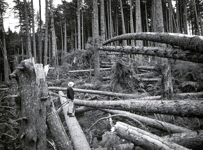
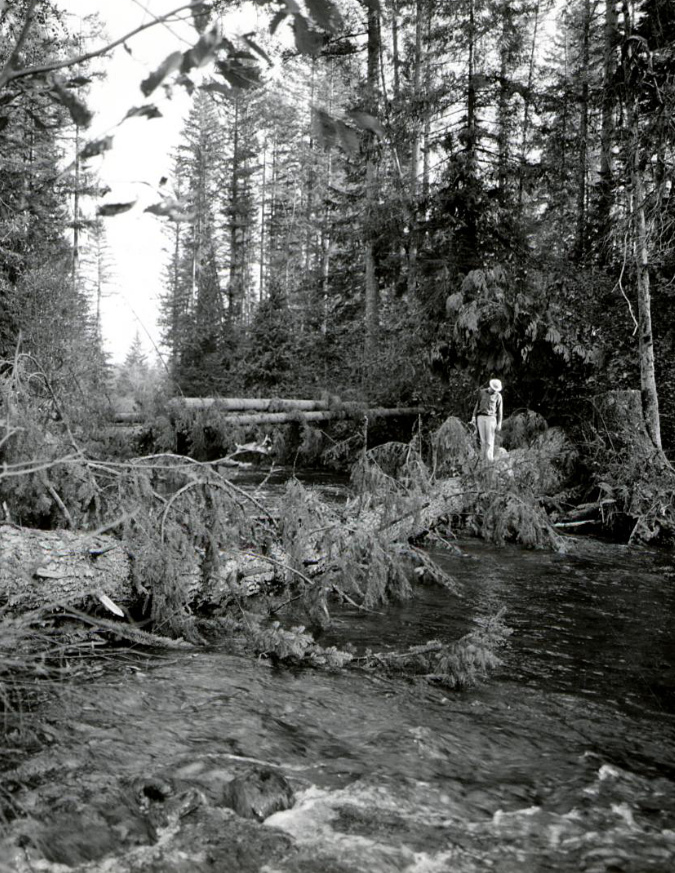
Blowdown in the Clackamas River drainage from the 1962 Columbus Day Storm
Because major wind events tend to affect larger trees, windstorms often have an inverse effect on subsequent forest recovery from wildfire. Low-intensity fires typically burn the understory while leaving large, fire-resistant species (like Ponderosa Pine, Western Larch and Douglas Fir) intact. In contrast, wind events often bring down the largest, oldest trees, leaving the understory intact.
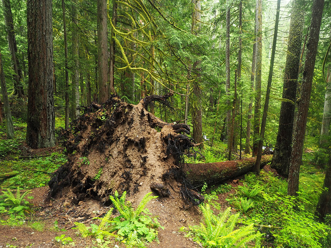
This effect of wind on the largest trees is an important part of forest health and succession, though one that has been recently appreciated and studied by scientists. If you’ve explored the forests around Mount Hood, you’ve probably noticed that uprooted conifers create large mounds of soil around their exposed root mass, and a shallow pit where the tree once stood. This freshly exposed soil combined with newly created access to sunlight to makes these disturbed spots a thriving seedbed for new understory plants and conifer seedlings. Over time, the fallen tree, itself, will also provide shelter and habit for wildlife, and as it decays, becoming a nursery for young trees.
While less common, snapped trees from extreme wind events also play an important role in forest health by providing habitat for cavity-nesting birds and mammals, while their decaying standing trunk becomes a food source for wildlife feeding on the insects and fungi that immediately begin digesting the wood.
Foresters rushed loggers into affected areas after the 1962 Columbus Day Storm to remove fallen trees for milling before they were “wasted” to decay in the forest
Blowdown events can affect areas ranging from a few dozen to a few hundred acres, typically in a patchy, highly variable pattern. Compared to blowdown along the uniform boundaries of a clearcut, scientists have also found that the complex shapes of large, natural blowdown areas helps speed forest regeneration from adjacent standing trees by leaving much of the affected area in close proximity to surviving trees that will reseed the impacted forest.
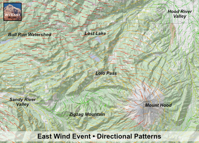
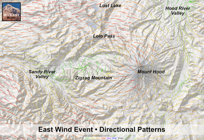
While snow and saturated soils can make our forests more vulnerable to high winds, elevation and exposure remain the drivers of major blowdown events. The September 2020 windstorm showed that even during our driest time of year, an unusually potent windstorm can have widespread impacts. The combination of wind speed, elevation and exposure correlated closely with the ridge tops and adjacent slopes where the heaviest blowdown occurred on Mount Hood. This event was especially unusual for late summer, as there was a strong, easterly wind blowing along the entire crest of the Cascades, as opposed to the normally westerly flow that dominates our region.
The two National Weather Service-based maps (below) for the September 2020 wind event are otherwise identical, except the second map excludes vegetation for ease of reading. The arrows point in the predominant direction of the wind during the event, and combine to show the rivers of fast-moving air that were flowing over the Cascades and toward the Willamette Valley. The arrow colors indicate wind speeds: green shows protected valleys where wind speeds were less, while orange shows steady winds of over 30 mph and red shows where steady winds exceeded 40 mph – though there were much higher wind gusts during the event, as well.
Wind map from the September 2020 wind storm showing the directional flow from east (right) to west (left)
This is the same map shown without vegetation to reveal the complex flow patterns as the wall of wind pressed across the Cascades from the east, roaring across high ridges around Mount Hood
The patterns revealed by the directional arrows show the air mass speeding up as pours over the Cascade Crest, from east to west, then rushes down the western valleys of the Cascades toward the Willamette Valley. Mount Hood forms a noticeable “wind shadow”, especially along the Sandy River valley, due west of the mountain, where sustained wind speeds dropped to 10 mph. The wind shadow of the mountain wasn’t enough to protect the forests along the upper slopes high ridges that radiate from the mountain, however, and this is where the main blowdown occurred.
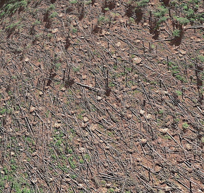
While these wind maps were created with a combination of monitored weather data and window flow models, the downed trees on Mount Hood north, west and south sides follow the pattern exactly. This satellite image (below) shows the blowdown areas along Yocum Ridge, where sustained winds of 40+ mph were sweeping down the west slopes of Mount Hood.
Google Earth images of Yocum Ridge from 2021 showing the extent of the blowdown
The closeup satellite image of the same area on Yocum Ridge (below) shows how consistent the sustained winds in this event were with the directional patterns that were modelled, with their toppled trunks pointing in the same direction as the arrows on the wind maps. The light-colored dots are tipped root balls from toppled trees.
This Google Earth view of the Yocum Ridge blowdown area shows the hundreds of upturned root balls dotting the September 2020 blowdown area
As distressing as it is to walk through a badly damaged forest after one of these events, we also know that extreme wind is a constant over time in our forests. Like fire, we have a history of treating these events as an anomaly, something out of the ordinary. Yet, research shows just the opposite – that extreme wind events and the blowdown that results are as much a part of our forest ecology as rain, snow and fire. Like the other natural forces, our forests have evolved with extreme wind as a relative constant, and the forest ecosystem is renewed by these events just as it renews and rebounds after a fire.
Rethinking Blowdown
Scientists categorize recurring wind events as “chronic” and “acute”. Chronic wind events include the typical storms that are part of every Pacific Northwest winter. These are the routine winds that annually shape the canopy of forests on lower slopes and sculpt our alpine “krummholz” trees at timberline. Except where forests are disturbed by clearcuts (as described above), these events typically don’t create significant blowdown, though they do invigorate tree growth by trimming limbs and selectively downing disease or drought-weakened trees.
“Acute” events are what our Cascade forests experienced in September 2020. These events may seem exceptional and catastrophic because of their impact, but they are as predictable as chronic wind – just on a longer scale. These are the events that produce significant blowdown, which, in turn, creates a cascade of beneficial effects for our forests.
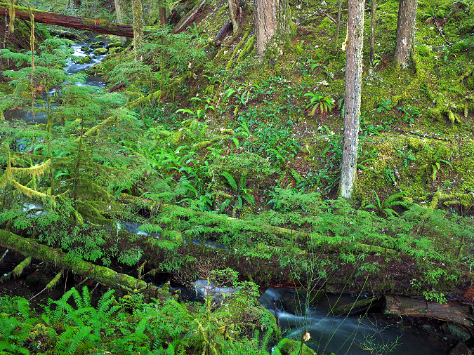
The rainforests on Mount Hood’s western slopes quickly hide blowdown with a thick layer of moss and ferns. There are at least a dozen fallen trees of varying size in these old-growth scene along Three Lynx Creek
While there are the immediate forest benefits of new forest openings, upturned soil and wildlife habitat created where downed trees fall, one of the most important benefits comes from the blowdown that makes its way to our streams. This can be from trees simply falling into streams (as shown above), or sliding down steep mountain slopes to reach nearby streams.
This satellite image of the Muddy Fork of the Sandy River (below) shows the immediate introduction of fallen logs just downstream from the September 2020 blowdown on Yocum Ridge. While only a fraction of the trees toppled by the storm made it into the Muddy Fork, they have already had an immediate and visible benefit by adding what biologist call “woody debris” to the stream. These logs will improve stream health by slowing the flow of runoff, creating pools for fish habitat and providing new wildlife habitat in and along the stream.
Google Earth image showing large log jams along the upper Sandy River just one year after the 2020 wind storm
Since the 1990s, scientists have become increasingly aware of the importance of woody debris to stream health. This awareness resulted from the lack of wood in our streams, following a century of fire suppression and heavy logging that deprived our streams of forest debris, leading to stream channel erosion and few pools for fish to spawn and their hatch to grow.
Logjam along Multnomah Creek resulting from upstream blowdown in the Eagle Creek Fire burn zone
This giant log was blown down across a stream in the Clackamas River drainage during the 1962 Columbus Day Storm. Old-growth logs can last for decades in a stream. This log likely survives today, more than sixty years later
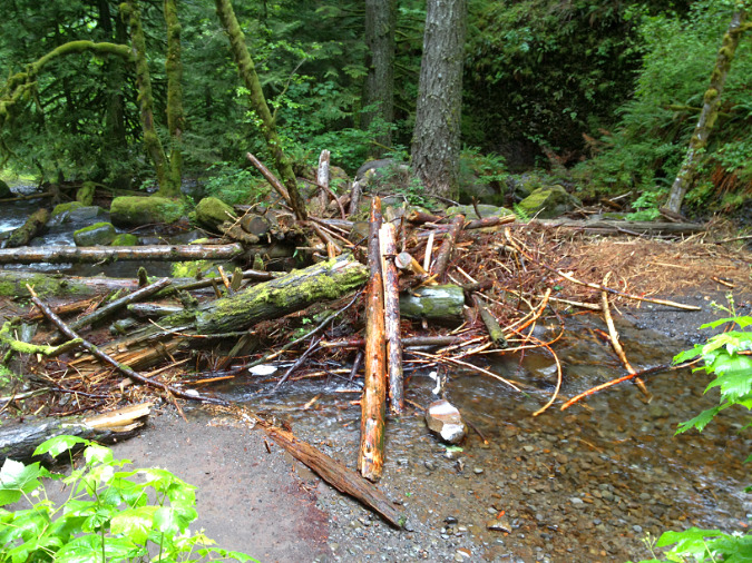
Today fish biologists have begun restoring streams affected by logging and fire suppression by artificially placing logs and root balls in streams to restore the complex mix of wood and gravel that was once typical in all of our Cascade streams and rivers. The man-made pile of logs in the example shown below is on Still Creek, which flows from Mount Hood’s south side. The hope is that these log piles will not only slow the stream and create spawning habitat for endangered salmon and steelhead, but also provide organic nutrients for aquatic insects and flora that fish fry need to survive.
Man-made log jam along Still Creek placed here to enhance fish habitat
The value of these logs to the stream habitat also underscores why “salvaging” fallen trees from blowdown events or wildfire burn areas for lumber – especially where they border streams – has long-term impacts on forest and stream health that we’re only beginning to understand.
Learning to “see” the benefits of blowdown
Where we do find healthy amounts of woody debris in our Cascade streams, it’s usually the result of a fire or wind event sometime in the distant past. Downed logs can last for decades (or even a century) lying in a stream or on the forest floor, so they help tell the story of how a forest has evolved. Just as we have begun to learn the benefits of fire in our forests in recent years, the 2020 windstorm gives us an opportunity to appreciate this force of nature with new insight, as well – as an awesome, destructive force that is equally one of rebirth and forest succession.
The following scenes from around Mount Hood country are places where the effects of blowdown in our forests are hiding in plain sight. Learning to “see” these events from the traces they leave behind, and learning to appreciate how they continue to shape our forests is the best way to rethink how we view blowdown events.
Log jams (including the man-made versions shown above) are easy enough to spot. But in time, logs gradually fade into the forest floor and sink into streambeds, often covered with moss and understory plants as they continue their decay. A healthy stream is full of these, with new downfall continuing to provide a steady supply of new debris. The following scenes (below) are examples of streams with a healthy supply of woody debris, both new and old.
Decades-old blowdown along the Little Zigzag River still providing habitat by forming pools and collecting woody debris in the stream, with newer blowdown visible just upstream
The small falls in this scene in the Clackamas River drainage is formed by an ancient Western Red Cedar that has likely been lying in this stream for as long as a century. This old log also catches smaller debris, further enhancing the stream habit
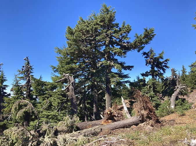
Tipped trees are a common sight in our forests, and they help tell the story of how wind is shaping the ecosystem. This old-growth tree (below) was among the largest in a mix-aged stand of mostly younger trees, and it demonstrates what scientists have observed: big trees are often the primary victims of wind events in healthy, mix-age forests.
This old tree’s demise is already giving rebirth to the forest. It’s upturned root ball and the cavity it created in the forest floor have already begun to be colonized by ferns and other understory plants after just one year, thriving in the bright spot of sunlight created by the fallen giant. The tree, itself, will continue to provide habitat for decades to come as it decays on the forest floor.
The root ball on this tipped Douglas Fir is beginning to decompose, leaving nutrient-rich soil newly exposed for new understory plants to take root
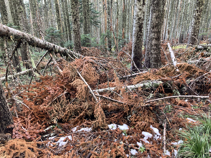
Small forest openings are one of the most important contributions of blowdown events. These scenes (below) are from a small blowdown area on Mount Hood that resulted from the 2020 wind storm. While seeing big trees toppled and broken is unsettling, the response of the understory after just two growing seasons to the sunlight provided by the new forest opening is equally inspiring. New life flourishes in these openings, where deer have abundant, new browse and other wildlife species thrive in the lush, rejuvenated understory. Soon, young conifers will take hold here, beginning the forest cycle, once again.
Small blowdown areas like this one along McGee Ridge area boon to forest health, allowing the understory to flourish in the new sunlight and young conifers to become established
Beneficial forest opening created by the 2020 blowdown event along McGee Ridge
It’s easy to forget that most small forest openings like the one shown above don’t just happen, they are usually created by wind events and blowdown. That’s because the evidence of the blowdown is so fleeting. Soon, the fallen trees in this blowdown area will disappear into the understory. Their limbs will fall away as they begin to decay, and their trunks will be pushed to the ground by gravity and winter snowpack, eventually becoming invisible to hikers passing by. Yet the effects of this blowdown event has created a forest opening that will endure for decades to come.
Fallen trees can last for a century or more in our forests, especially large trees. Eventually, however, they decay into a long, deep pile of mulch that becomes a nursery for understory plants and conifer seedlings. This is common on the western, rainforest side of the Cascades, where these are known as “nurse logs”. The first example (first two images, below) jumps out because a hiking trail happens to run parallel to the nurse log. The second example (third image) shows a nurse log still spanning a stream, even as it hosts a new forest of young conifers.
In Oregon’s west-side rainforests, downed trees eventually become “nurse logs”, with young trees growing along their length as the log decays and blends into the soil. This log happens to form the border of a hiking trail
This is the same log in the previous photo as viewed in the opposite direction to show the trees growing atop this decaying “nurse log”
Nurse logs often span streams, as in this case on Tag Creek in the Clackamas River area (lower part of this image). Eventually, this log with buckle and fall into the creek, though some of the Western Hemlock seedlings growing on it will likely survive to continue growing along this stream
It’s easy enough to spot fallen logs in our forests and to appreciate the role of wind in creating forest openings or stream habitat. But one of the less obvious benefits of blowdown might be the most important – the role that wind plays in creating multi-aged, biologically diverse forests. When you find yourself in a multi-aged stand of trees ranging from ancient old growth to seedlings, you’re seeing centuries worth of alternating wind and fire events at work, gradually culling both the forest understory and overstory over time. The result in the Pacific Northwest are forests with a sheer biomass and ecological diversity that is unrivaled in North America.
The following scenes show mixed-age, mature forests shaped by wind and fire. In each case, the conifer overstory ranges from old-growth giants to mid-sized and younger trees. Bleached snags, downed trees and young conifers emerging from the understory mark a new opening created by blowdown.
Healthy conifer forests have multi-aged stands of ancient, mature and young trees with standing snags, like this forest on the slopes of Bald Mountain, near Lolo Pass
Healthy, multi-aged conifer forest on the slopes of Bald Mountain
The previous images (and the one below) were captured along the Top Spur trail, on Mount Hood’s west side. While most hikers pushing up this popular trail have their attention focused on popular destinations like McNeil Point, the forest along this short trail is among the best examples of a multi-aged, subalpine stand on the mountain. It was very nearly logged, too – the name “Top Spur” refers to the logging spur that now forms a crowded summer trailhead instead of the log landing that once operated here. Today, it is protected as wilderness.
Multi-aged Noble Fir forest in winter on Bald Mountain
Noble fir giants dominate the forest along the Top Spur trail, but you will also find Western Redcedar along the tiny stream that runs through the area. Where fallen logs have been sawed out to keep the trail open, count the rings – you’ll find that even the trees that are 12” in diameter are more than a century old in this challenging, subalpine environment. The largest trees have been growing here for several centuries, and are living witness to the succession of storms and fires that have shaped this thriving forest. And while hikers may curse the tangle of roots exposed on this well-traveled trail, they tell a story of a mountain slope that is quite literally held together by the lush conifer forest that is thriving here.
Want to see this forest? It’s a short hike from Top Spur to the site of an old forest lookout on Bald Mountain that begins in this beautiful old growth forest, then climbs through a very young forest where “Bald Mountain” is a bit less bald (ironically, thanks to fire suppression aided by the former lookout).
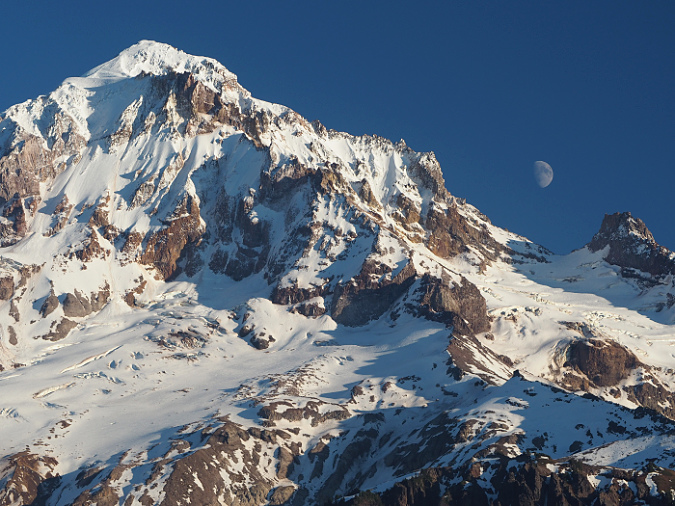
Moonrise over Mount Hood from the top of Bald Mountain
The view of Mount Hood from the top is stunning and worth the short, often steep hike. Oh, and you’ll probably have to step over some blowdown, too… but hopefully with new appreciation! You can find a hike description here:
..and yes, you might recognize the author of that particular field guide entry…
______________
(Author’s note: as always, thanks for reading this far, and apologies are in order for my absence in recent weeks! I’ve got plenty of articles in progress, just lacking time needed to get them posted. I hope to get back up to speed shortly!)
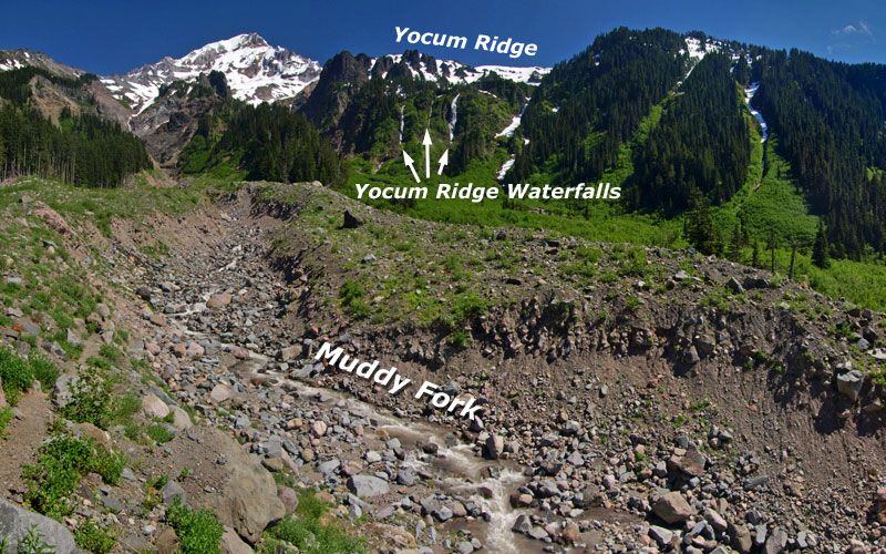
Scores of little-known waterfalls hide in Mount Hood’s backcountry. Some are towering glacial torrents, while others are quiet forest cascades, framed in moss and maple leaves. But when conditions are right, few rival the towering trio of waterfalls that mark peak snowmelt on the upper ramparts of Yocum Ridge.
These waterfalls are unnamed and unmapped, but familiar to hikers crossing the Muddy Fork on the Timberline Trail or visiting McNeil Point, across the canyon. They completely disappear by autumn in dry years, but in early summer, they are Mount Hood’s roaring counterparts to the famous seasonal giants of Yosemite.
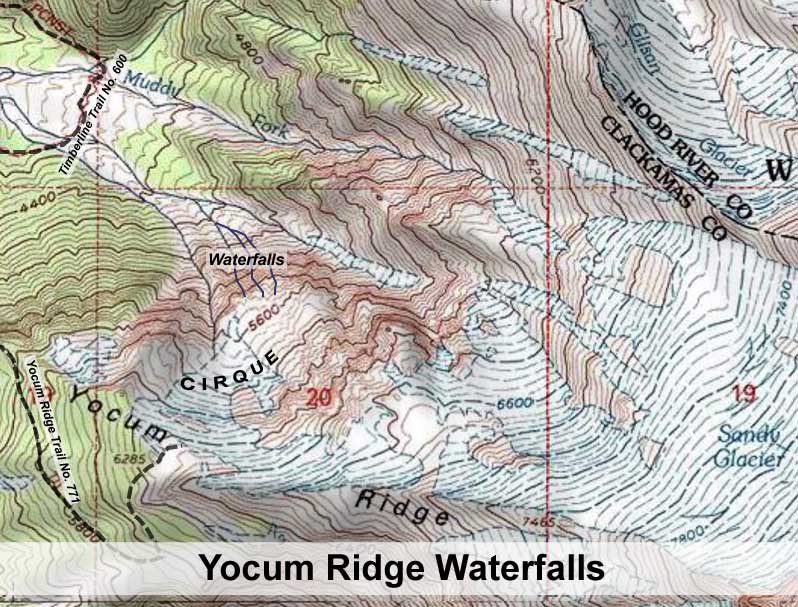
These waterfalls originate from an unnamed glacial cirque, or bowl, high on the northern shoulder of Yocum Ridge, the massive spine that divides the Muddy Fork from the Sandy River, and extends to the summit of Mount Hood. Though they flow from a relatively small basin, the snowfields that accumulate in the cirque each winter generate a surprisingly powerful runoff.
In recent decades, the year-round snowfields in the basin have almost disappeared, compared to 1960s-vintage USGS maps (below). This seems to have opened a more direct snowmelt channel to the waterfalls, as they seem more prominent in recent years, while the perennial stream to the west, as shown on the USGS maps, has become much less prominent.
The cirque is well below the tree line, so the lack of forests in this amphitheater is also a good indicator of both heavy snow accumulations and frequent winter avalanches.
The view (below) from across the canyon shows the waterfalls in relation to Yocum Ridge and the cirque. The low ridge to the right of the falls forms a lower cusp of the cirque, and this ridge serves as a dike that channels most of the spring runoff toward the waterfalls. The Yocum Ridge Trail (shown on the map, above) terminates at the rim of the cirque, in the extreme upper right corner of this view:
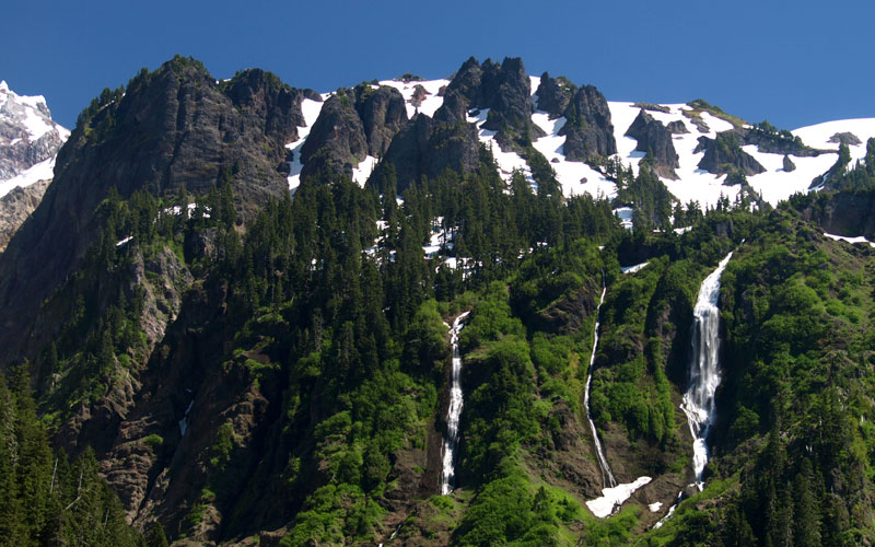
A closer look at the waterfalls, as viewed from below at the Muddy Fork crossing (below), shows the rugged upper crags of Yocum Ridge in the background, with the waterfalls tumbling from the cirque into the Muddy Fork canyon. The cirque is located to the right, just outside this frame.
Surprisingly, a sizeable forest is perched on the slopes to the left of the waterfalls, apparently spared by the most frequent avalanches that have cleared most of the slopes within the cirque.
It’s somewhat unknown how the streams that feed these waterfalls originate, since they are not mapped, and perhaps not even explored. However, from Google Earth imagery, the trio of waterfalls seem to flow from three distinct sources, with the western falls draining the main portion of the cirque, and the middle and east segments draining directly off the upper slopes of Yocum Ridge.
A closer view (below) shows the trio of waterfalls in detail. The westernmost of the three (on the right) is by far the largest, dropping at least 700 feet in the main cascade, and arguably nearly 800 overall. This drop is on a scale with Multnomah Falls, which drops a total of 635 feet, by comparison.
The eastern segment (on the left) is next in size, and though dwarfed by its larger sister to the west, is quite large and drops at least 500 feet. The middle segment is a tall, thin slide that is nearly as tall as the western segment, albeit much less dramatic.
The towering western falls (left) starts out as a 100-foot slide, and quickly fans out for 150 feet before leaping over a wide, 400-foot plunge.
The falls collects in a steep amphitheater at the base of the main plunge before making a final 70-foot plunge into a roiling, narrow gorge.
A closer look at the main plunge of the western falls (below) reveals the raw power at work during peak snowmelt, with its roaring curtains of falling water.
Somehow, thickets of red alder cling to the cliffs around the falls, framing the scene. This spectacle persists for several weeks in early summer, yet nearly disappears in autumn and through the winter.
The following video captures this dramatic scene, as viewed from the Muddy Fork crossing on the Timberline Trail in July 2010:
_________________________________________
How to visit the Waterfalls
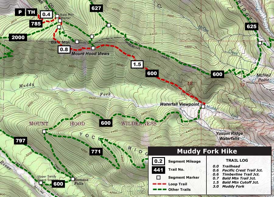
Viewing the Yocum Ridge Waterfalls up close makes for a terrific day hike, and the waterfalls are at their prime as soon as the trails open — usually late June or July. The recommended 5.4 mile (round-trip) hike shown on the map below starts at the usually crowded Top Spur Trailhead, near Lolo Pass. But most of the hikers are heading for McNeil Point, so you will see very few people beyond the series of junctions at Bald Mountain.
Starting at Top Spur, the trail climbs somewhat steeply for 0.4 to a signed junction with the Pacific Crest Trail (PCT). Turn right onto the PCT, and immediately reach a confusing 4-way junction with the Timberline Trail. Turn right onto the famed Timberline Trail, heading uphill and to the right, past a sign pointing to the Muddy Fork
The Timberline Trail climbs gently through noble fir forest, soon passing the unmarked junction with the Bald Mountain trail. A short distance beyond, the trail traverses across the steep meadows on the south face of Bald Mountain, with stunning views of Mount Hood and the Muddy Fork canyon.
Mount Hood and the Muddy Fork canyon from Bald Mountain
After re-entering the forest, the trail passes yet another junction, this time with the unsigned Bald Mountain Cutoff. Head straight, going through a log gate before making a very gradual descent to the Muddy Fork.
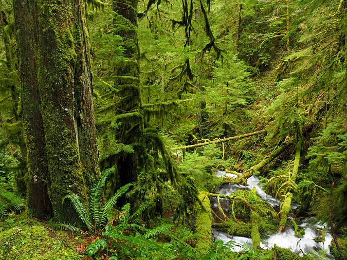
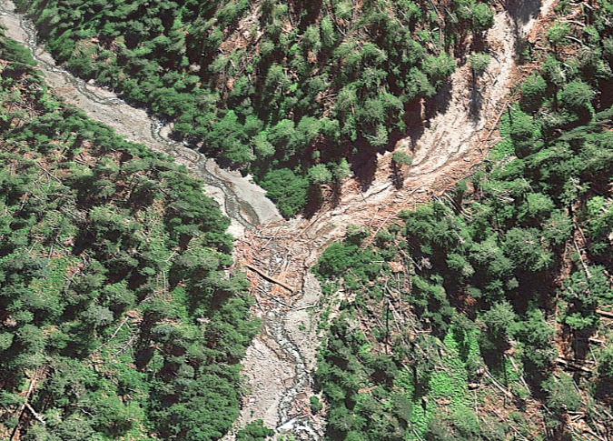
Once at the Muddy Fork, the trail enters the scene of a violent debris flow that crashed through the area in 2002, snapping thousands of mature trees like match sticks and pouring 20 feet of debris across the valley floor.
The Muddy Fork has made short work of the debris in the subsequent 10 years, cutting all the way down to its former stream level. This makes crossing difficult for Timberline Trail hikers, but that’s okay: the best view of the Yocum Ridge waterfalls is from one of the scores of boulders resting atop the debris flow, where you can relax and take in Mount Hood, the waterfalls and the roaring Muddy Fork, below.
Be sure to bring binoculars and a camera — and enjoy!


