Columbia Prickly Pear?

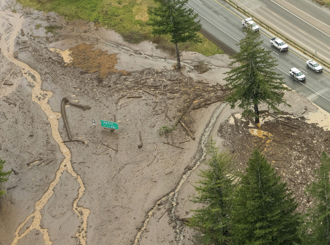
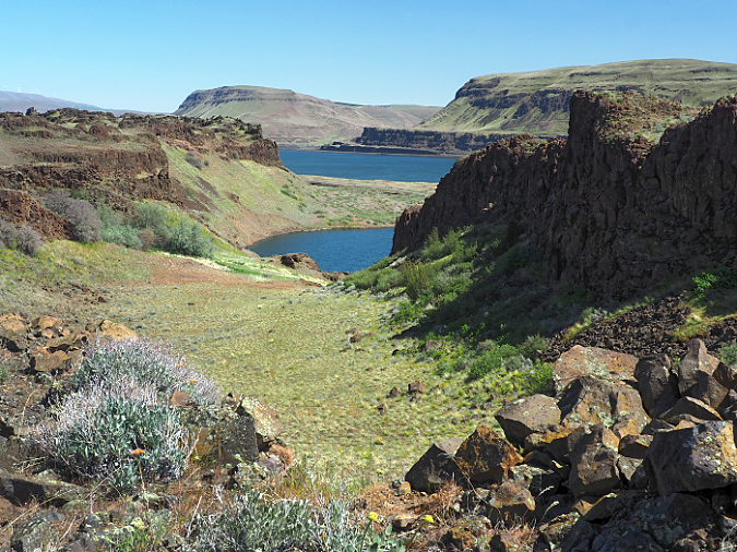
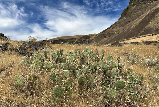
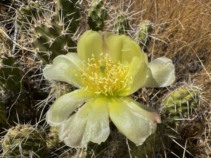
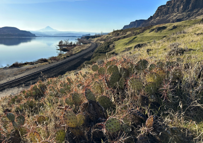
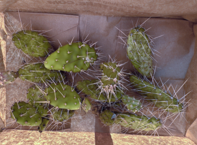
Columbia Prickly Pear colony thriving on the morning side of WyEast

I am a cactus fanatic. As a seven-year-old, I had a row of them in my bedroom window. They were little collectibles in 2-inch pots that you could buy at Fred Meyer for 49 cents. On my first road trip to the Desert Southwest in 1984 I couldn’t get enough of them. That was the first of many trips, often timed to capture cactus in bloom – to me, the ultimate in wildflower beauty.

Cactus are the rattlesnakes of the desert wildflower community. They combine exquisite beauty with remarkable evolution for a strong self-defense. Did you know that cactus spines are really their leaves, modified for both defense and shade? Or that the pad on a prickly pear cactus is really a thickened stem that carries out photosynthesis in the absence of green leaves? They have evolved to a point that seems downright alien to most other flowering plants.

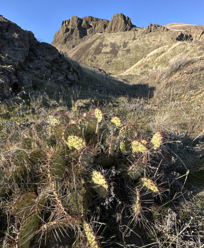
Brittle Prickly Pear colony growing in the Painted Hills Unit, John Day Fossil Beds National Monument

A few years ago, I came across my first prickly pear cactus in Oregon. It was one of our native species, Brittle Prickly Pear, growing in the John Day National Monument at the Painted Hills Unit. I revisited that patch a couple of times over the years, and finally saw it in bloom – another highlight! 

Since then, I have found dozens of Brittle Prickly Pear colonies all around the Painted Hills and adjacent Sutton Mountain areas, often covered with blossoms in late May and early June. Even in bloom, these plants are easy to miss in their native desert habitat. Their compact pads are rounded, about the size and shape of your thumb, and covered in grey spines that also act as camouflage against the desert floor. A mature plant has 20 to 30 pads growing in a low mat that is usually less than 6 inches tall. 

Brittle Prickly Pear blossoms at Sutton Mountain, near the Painted Hills

Brittle Prickly Pear bear fruit after blooming and can spread by seed, mostly by birds who navigate the cactus spines to feed on the soft inner part of the fruit. Called “tunas”, their fruit is sweet, putting the “pear” in their common name. Like other Prickly Pear species, they have long been used by indigenous people as a food source and medicinally. Fruit from larger Prickly Pear species is still used to make jams and other foods in Native American and Mexican culture.

Their heavy coat of spines and the ability of pads to freely break away is how Brittle Prickly Pear most commonly reproduce. When kicked loose by deer hoof or hiking boot, a stray pad is given a chance to take root and start a new patch in a local colony of cactus. This is how these “brittle” cousins in the Prickly Pear family earned their common name.

Our northern cactus may be diminutive in stature, but they are built small for a reason. Unlike their much larger relatives in the Sonoran Desert, ours endure bitter winter cold and months of winter storms that would flatten the larger cactus you might see in the Sonoran deserts of Arizona or New Mexico. 

Ahab and Moby Cactus…

Given my cactus obsession, I had it in my mind to someday see another of our local cactus: the Columbia Prickly Pear, a species that only grows in low-elevation deserts of the Columbia River and Snake River basins. It became my white whale, and I was determined to see Moby Cactus!

There is still some debate as to whether these are a separate species or a hybrid of our Brittle Prickly Pear and Plains Prickly Pear. The latter is a much more common species that grows across much of the West. Botanists have yet to fully agree on this, so for now Columbia Prickly Pear is called Opuntia Columbiana X Griffiths. The last part of the Latin name comes from botanist David Griffiths, who first documented the species for Western science in the 1920s. 

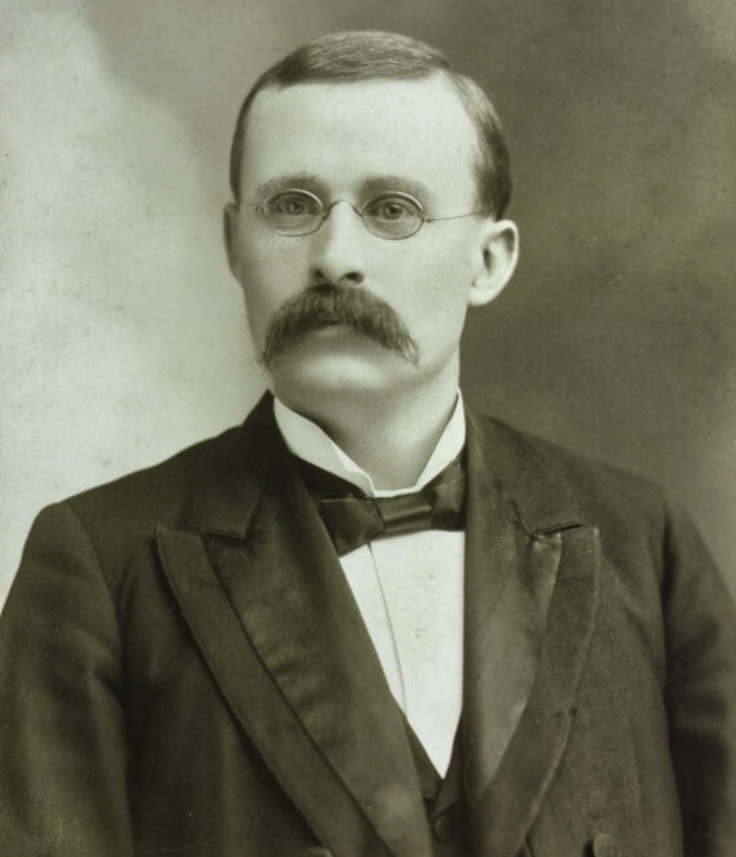
Pioneering western botanist David Griffiths in 1903 (Università di Padova)

Griffiths was from a Welsh family that immigrated to South Dakota in 1870, when he was just three years old. He earned a doctorate in botany from Columbia University in 1900, and went on to distinguished career as a groundbreaking scientist working for the U.S. Department of Agriculture (USDA). There, he spent the first part of the 20th century traveling across the American West documenting plants and photographing the range conditions of the Great Basin at a time when the impacts of fencing and heavy grazing on the desert ecosystem were first beginning to appear. 

His work was seminal in helping the USDA improve range management practices on our public lands across the West. When Griffiths died in 1935, he donated his botanical records and collection of glass-negative photographs to The Smithsonian National Museum, along with hundreds of Opuntia specimen that he had collected over his career. The Smithsonian describes his archives in bulk terms — 43 cubic feet, to be exact!  Griffiths’ field research legacy is still cited by today’s botanists and rangeland scientists, and his name lives on in our local Columbia Prickly Pear.

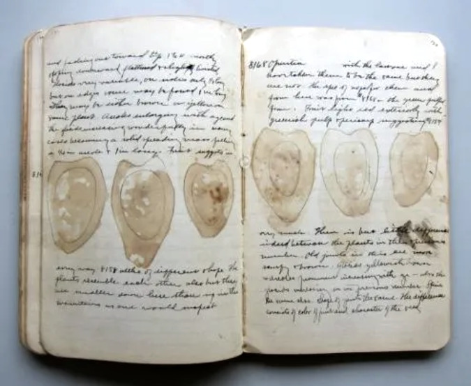
One of David Griffiths dozens of field notebooks. These pages describe the inside of Prickly Pear fruit. He is believed to have sliced fruit open and simply pressed them against the page to create these images (Smithsonian Museum)

Though David Griffiths has come to be remembered mainly for his passion for the Opuntia family of cactus, his interest in these tough, versatile survivors initially came from a belief that they could somehow be a livestock feed source on the open range. As odd as this sounds, the pads and fruit are already important for deer, antelope, squirrels and other wildlife who either consume the pads whole or work around the spines to get to the flesh. Other wildlife are more opportune, and consume Prickly Pear after range fires have swept through, searing their spines off. This is precisely how indigenous people prepared the nutrient-rich pads and fruit as a first food for millennia, though the spines were also used for sewing, fish hooks and other purposes.

Not too long before Griffiths first cataloged Prickly Pear cactus, white immigrants to the American West discovered them, as well – and not in a good way.  Journals from the Oregon Trail describe the misery of migrants stepping through prickly pear as they crossed the western plains in worn out shoes, as most who traveled the Oregon Trail walked beside their wagons for much of the journey.

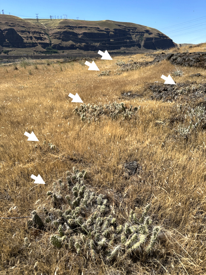
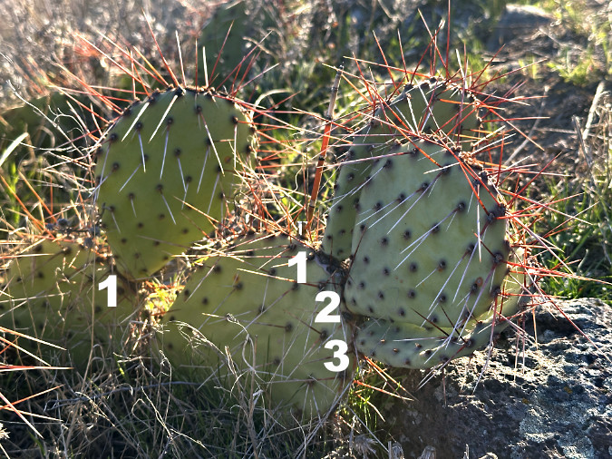
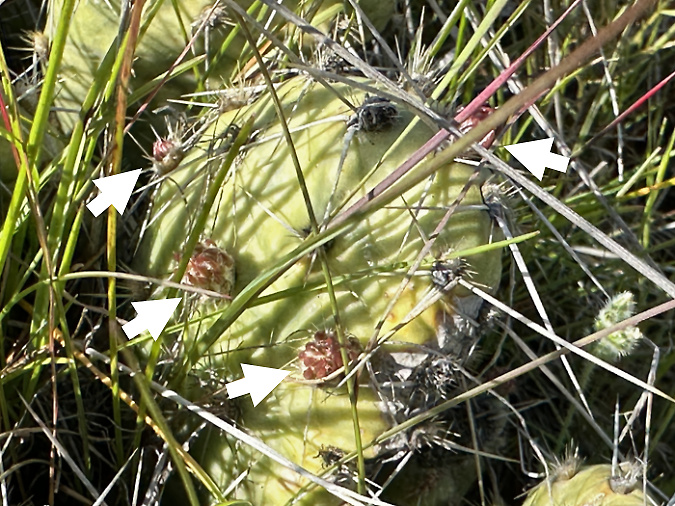
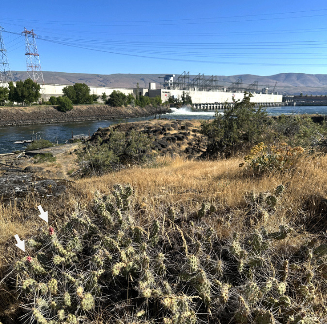
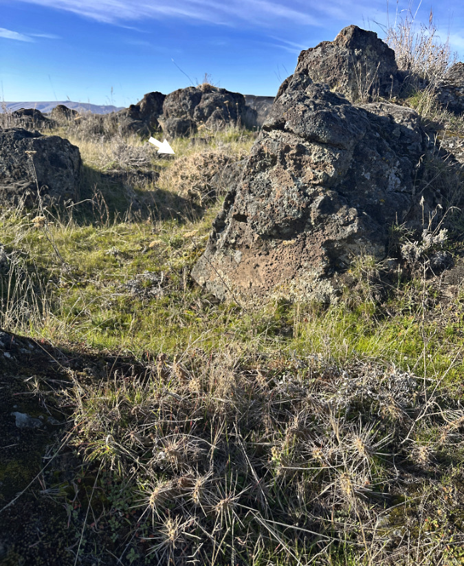
Our native cactus are easy to miss in the wild. There are at least five patches of Columbia Prickly Pear in this colony along the Columbia River – marked by arrows. In spring, they are especially well-hidden in new, green grass

Having skewered myself a few times with their spines, I can attest to the lingering soreness that comes with getting poked by a Prickly Pear. I suspect native peoples were more adept at navigating them — even nurturing them, perhaps, since they were valued for their food and cultural value. The photo above gives a sense of how well-camouflaged our Columbia Prickly Pear are in the desert grasslands and sagebrush country of the eastern Columbia River Gorge. The arrows point to several patches of cactus in this colony, each no more than 10 inches tall, yet wide enough to snare an inattentive foot!

The 2025 cactus hunt…

Local wildflower buffs and botanists had already done the hard work and locating Columbia Prickly Pear in the east Columbia River Gorge, making my mission much simpler. There were at least three well-documented colonies, and knowing this, I made 2025 the year that I would see them for the first time – and perhaps even photograph them in bloom.

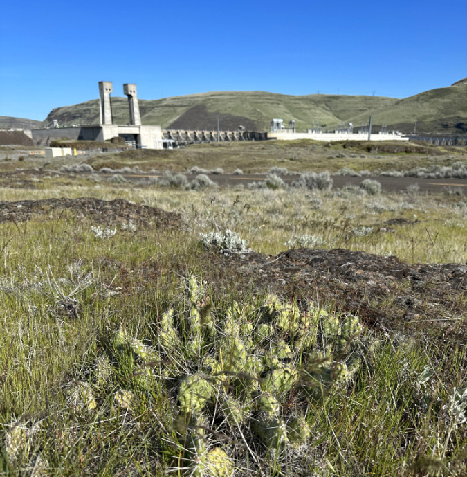
I initially set out over the winter to simply locate the known colonies from fairly general maps posted online. The first colony was located across the river from the Dallas Dam in a most unlikely spot, surrounded by buzzing transmission lines from the dam and traffic noise from interstate 84. However, this colony was also safely within the confines Seufert Park, a Corps of Engineers site adjacent to The Dallas Dam visitor center.

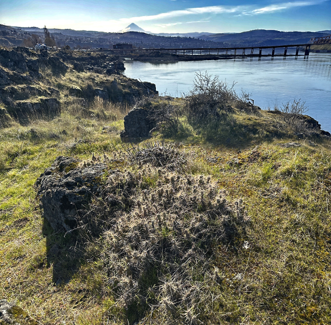
Columbia Prickly Pear thriving just upstream from the Columbia River Bridge in The Dalles. While these can be tough to spot in spring and summer, they stand out strikingly in winter with their spines capturing the low-angle sun and surrounding grasses dormant and flattened by the winter elements

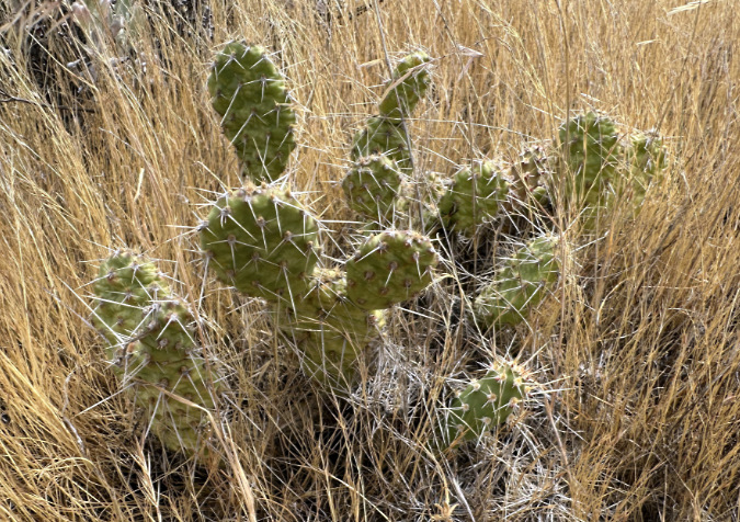
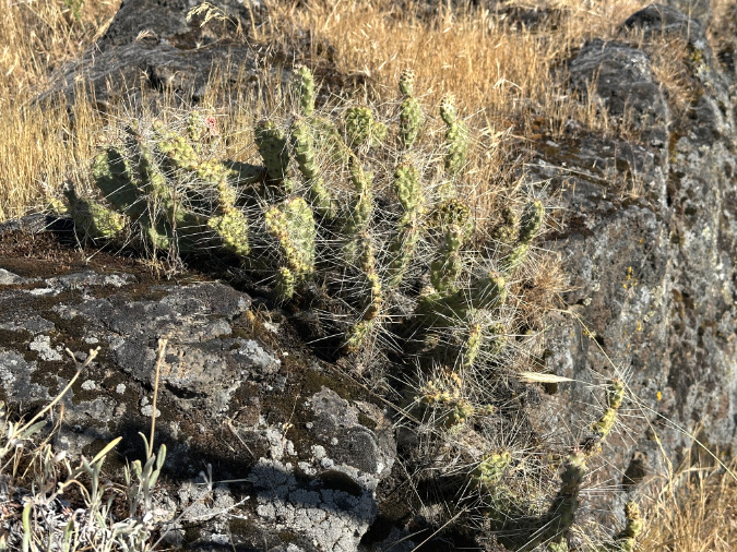
A short trail hike and a bit of cross country exploring took me straight to a colony of about a dozen cactus patches. They looked much like their Brittle Prickly Pear cousins, though their pads were more flattened and slightly larger. It was a thrill to see them growing right here in WyEast country, with the Columbia River spreading out below and Mount Hood shining on the horizon. I’d found my whale!

The next stop took me across the river to Avery Landing, another Corps of Engineers recreation site, just upstream from Columbia Hills State Park and Horsethief Butte. Expecting to find a similar colony here,  I wasn’t prepared to find a much larger group of much larger plants! The pads on these plants were as much as 6 inches across, and flat like the Prickly Pear cactus I had seen in the Desert Southwest. These plants stood as much as 2 feet high, and were growing on a high, rocky bench with a beautiful backdrop of the Columbia River and Mount Hood, beyond.

Prickly Pear cactus at Avery Landing grow on a rocky bench, a few hundred feet above the park and Columbia River. These are much larger plants than what I saw at Seifert Park.. why?

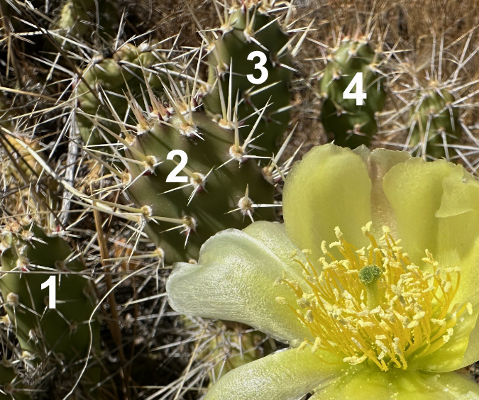
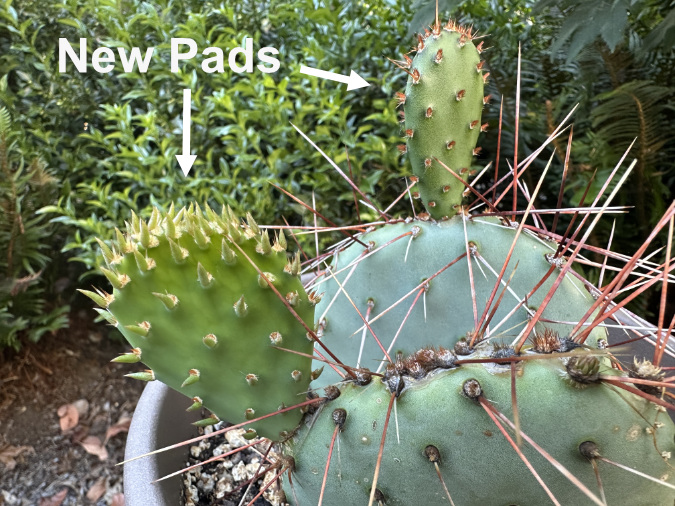
With the summer grasses and wildflowers dormant, the structure of Prickly Pear on these very large plants was easier to understand. New pads – the modified stems – grow from nodes on the edge of older pads, with typically 1-3 new pads emerging each spring, as shown below. 

How Prickly Pear grow, typically with one to three new pads forming on the margins of an older pad

Over time, this growth habit eventually tips the plants over from the successive weight of each new pad, making them seem to be growing horizontally. When pads touch the ground, they can easily take root, forming a new plant and helping further spread the patch from the original, parent plant. In the image below, each successive pad marks at least one year of growth, as new pads don’t always form on old pads. Thus, this stem of four successive pads is at least four years old, with the newest pad nearly touching ground where it might take root.

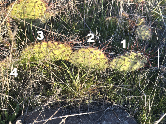
This chain of Prickly Pear pads originally stood upright, but has gradually tipped and sprawled with the weight of each successive new pad. Eventually, these pads can root and form new plants if they touch the ground

Though not as common, some older pads that support many newer pads eventually become woody stems to support the load. The image below shows how these stems gradually change from green, energy-producing pads to brown, more conventional stems. The pad near the woody portion of the stem is undergoing this transition, having lost the chlorophyll from the lower portion of the pad.

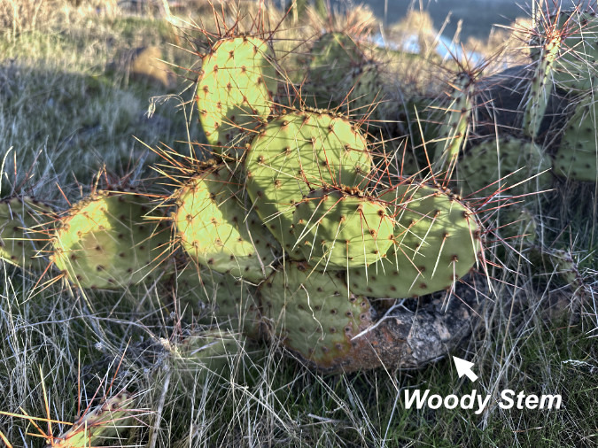
This Prickly Pear at Avery Landing has developed a woody stem from what was once a green pad in order to hold up the heavy load of successive pads that have emerged

For a cactus fanatic, exploring the colony at Avery Landing was a heady experience! But I had one more colony to visit in completing my initial tour of Prickly Pear in the Gorge.

The final winter stop took me Cliffs Park, yet another Corps of Engineers site, located on the Washington side of the river at John Day Dam. This is a familiar place to me, as I have photographed the beautiful river scenes and ancient gravel beaches that line the Columbia here many times. Using online maps, I found just two small plants that were about the same size in stature as those in Seaford Park, but in much smaller patches. It was a disappointing stop, especially compared to the large colony of very large Prickly Pear at Avery landing. Did I miss something?

Like the Columbia Prickly Pear at Seifert Park, the small colony at Cliffs Park grows in the shadow of one of the massive Columbia River Dams. The John Day Dam rises above this cactus patch

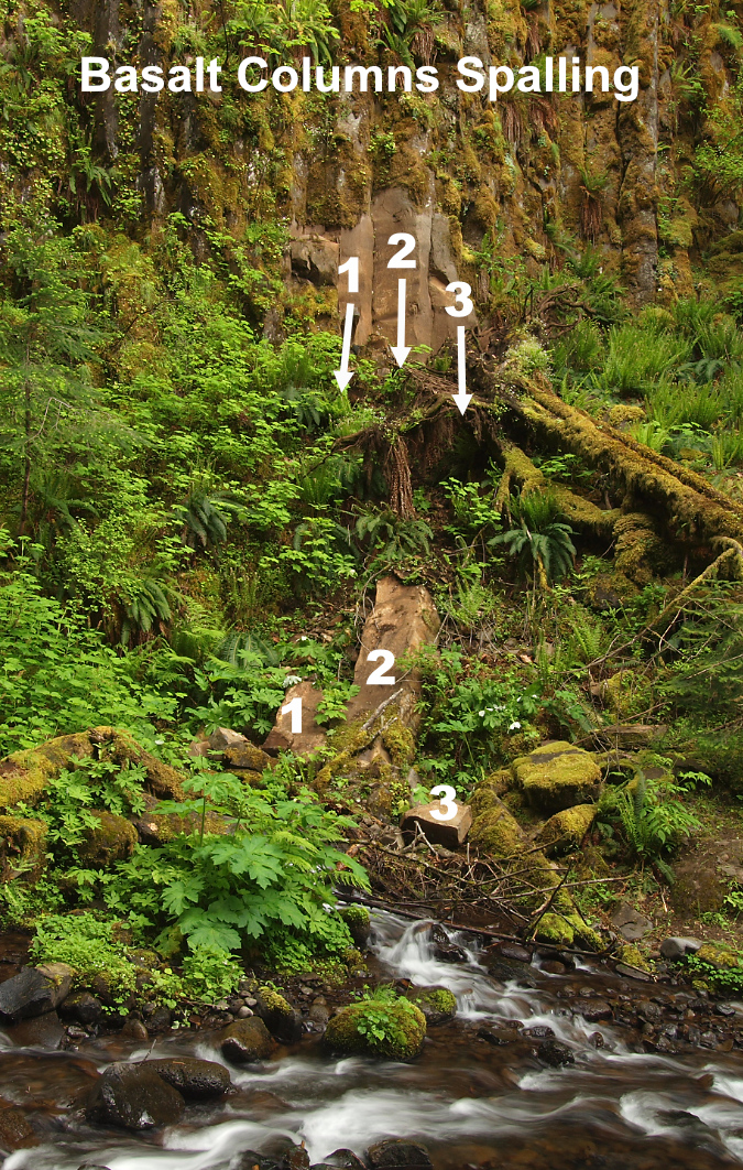
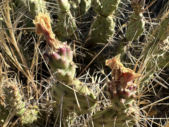
However, as I was photographing the small colony at Cliffs Park, I noticed new buds emerging from some of the pads (below). Were these flower buds or new stems? Surprisingly, some of the buds were also located on the flat side of the pad in addition to the edges. This was quite different from what I had seen at Avery Landing. I was now determined to come back and do a more thorough search in this area and document the growth of these buds in spring.

The arrows point to new buds emerging from this Columbia Prickly Pear at Cliffs Park in early March. Are these flower buds or new pads forming?

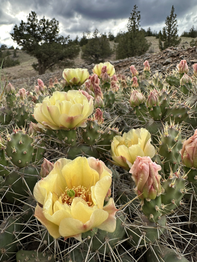
As spring approached, I made several more visits to the impressive colony at Avery Landing, and was especially excited in early May to find the plants loaded with flower buds (below). These buds developed very quickly, over just a couple weeks. 

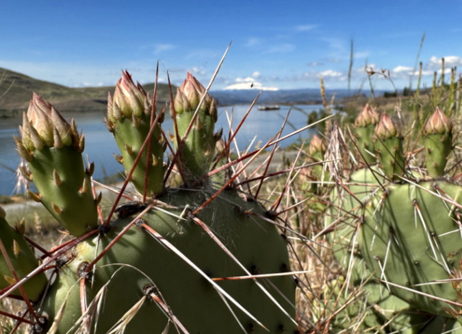
Hundreds of flower buds were nearly ready to open at the Avery Landing Prickly Pear colony in mid-May

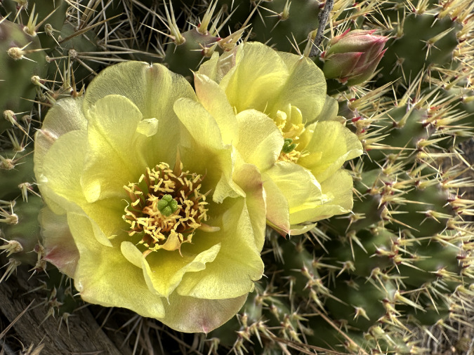
When the Avery landing colony finally began blooming in late May, I was there with my camera to capture it all, including a photo with the trifecta of cactus blossoms, Mount Hood, and the Columbia River that I had been hoping to capture (second photo, below).

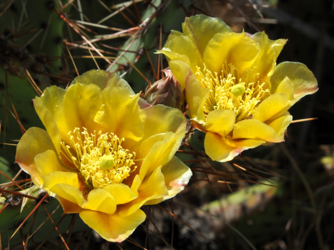
The first Prickly Pear blossoms to open in the Avery Landing colony in late May

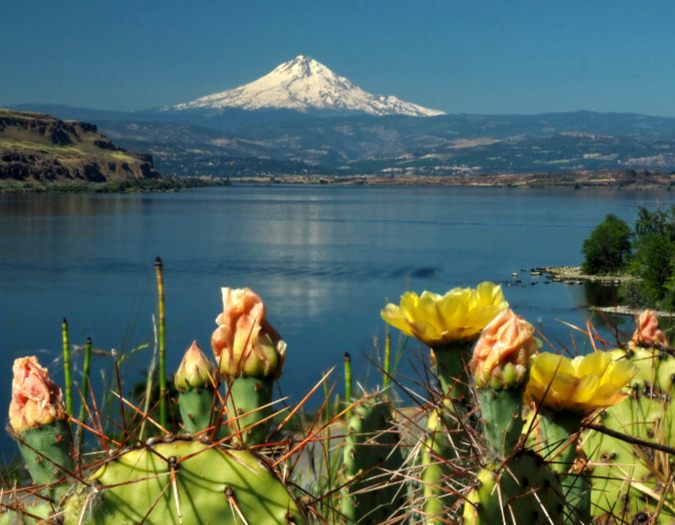
Trifecta! Blooming Prickly Pear, the Columbia River and Mount Hood a few days after Memorial Day in late May

However, this is where the story takes an unexpected turn. When I took these photos, I thought the Prickly Pear colony at Avery Park to simply be a more vigorous, over-achieving version of the same Columbia Prickly Pear growing across the river, at Seufert Park. Perhaps their much larger size was simply a reflection their habitat? Where the Seufert Park and Cliffs Park colonies were growing on arid, thin soils atop basalt outcrops, the Avery Park colony grows in deep, sloping sand and gravel deposits left behind by the Missoula floods. Perhaps these soils simply offer more moisture and nutrients than are available to their smaller neighbors across the river?

Only after sharing photos of the Avery Landing colony in an online wildflower community, did I learn that the Avery Landing cactus were not our native Columbia Prickly Pear at all! Instead, these are Desert Prickly Pear, an introduced species known as Opuntia Phaeacantha that grow across much of the desert southwest and into the southern Great Basin. Fact is, their true identity wasn’t completely surprising to me, as the growth habits and size of the two species are so different. But it was disappointing.

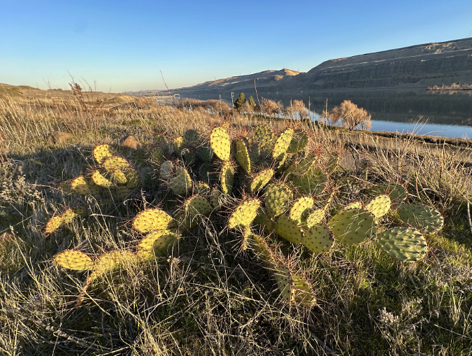
Desert Prickly Pear is the true identity of the introduced cactus species growing at Avery Landing

It’s hard to say whether these Desert Prickly Pear were planted here intentionally or arrived here accidentally, but they are thriving now. They have formed an extensive colony of at least 25 separate groups that span a 100-yard long bench above the Columbia River. Their size and the extent of the colony suggests they have been here for some time – likely decades or longer – so they are clearly here to stay.

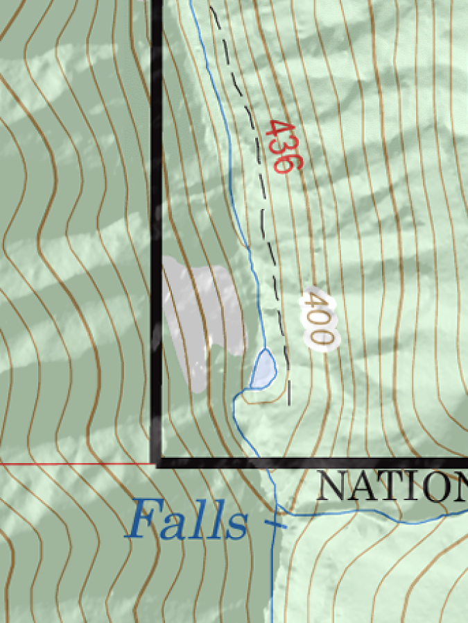
It’s hard to know exactly how the Desert Prickly Pear cactus have been spreading in the Avery Park colony, but because they are mostly clustered along an abandoned road grade (as highlighted on the map below), their spread here could simply be from human or wildlife activity kicking pads loose to root and begin a new patch.

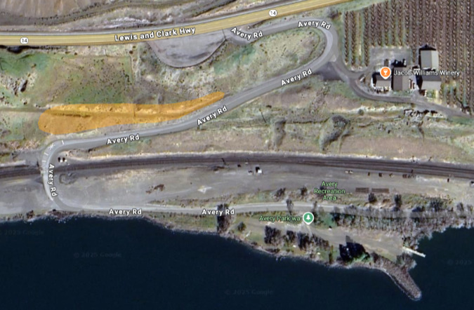
The Desert Prickly Pear colony at Avery Landing grows on a gravel bench that splits off the access road to the park. The separate groups that make up the colony fall within the highlighted area on this map

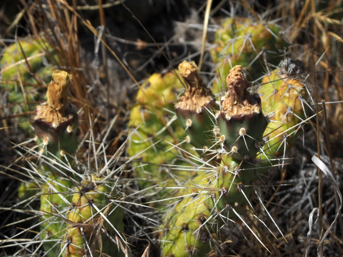
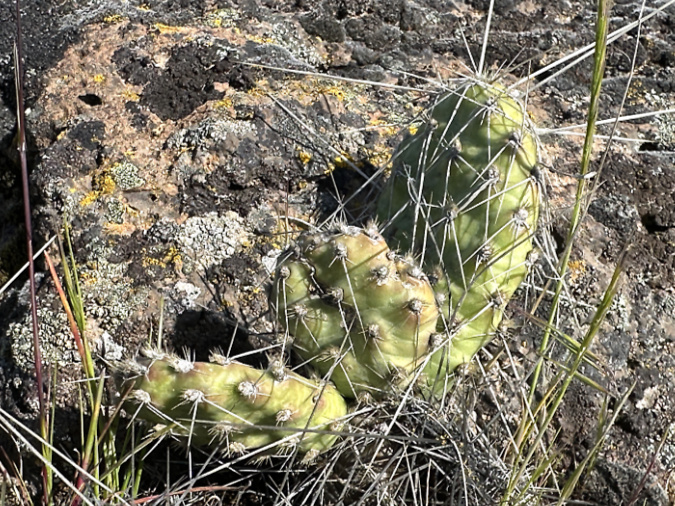
However, when I visited the colony again in mid-June, the blossoms had mostly faded and the colony was busy forming hundreds of fruit – tunas – that I think might be the primary explanation for the size of the colony. That’s because there is plenty of wildlife sign here, including a very active colony of California ground squirrels living in the basalt outcrops that border the bench. I suspect they are among the wildlife species feeding on the fairly large tunas and thereby spreading their seeds.

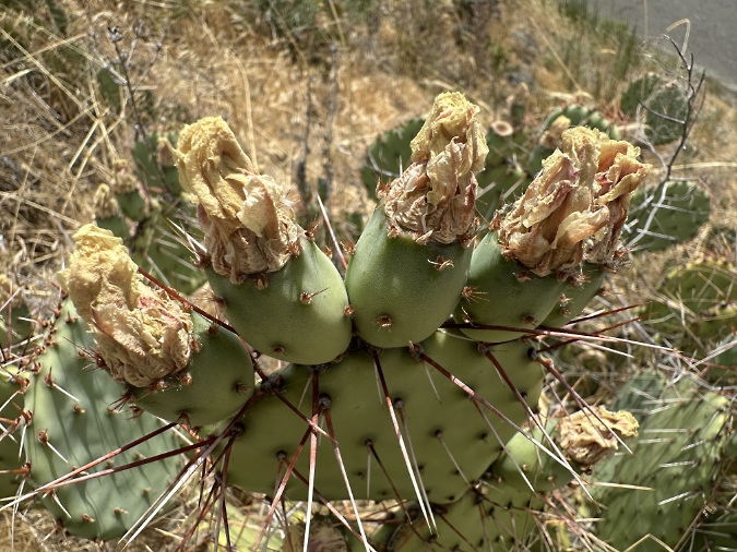
Desert Prickly Pear blossoms have dried up on this plant by early June. They will soon drop off as the fruit beneath ripens

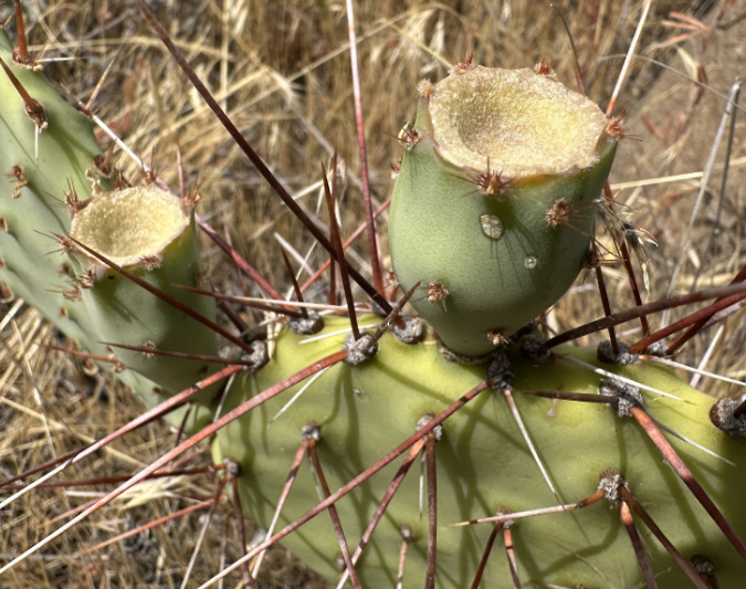
Desert Prickly Pear fruit after blossoms have fallen off in mid-June. They will eventually turn to a reddish-purple color as they ripen

As disappointing as the revelation of their true identity was, the colony of Desert Prickly Pear at Avery Landing is nonetheless a spectacular sight. We may be seeing our future here, too, as climate change spurs plant species from across the spectrum to migrate northward as our Pacific Northwest climate becomes warmer. Already, this colony of Desert Prickly Pear is proving the eastern Columbia River Gorge to be an ideal habitat for a species whose native range is nearly 1,000 miles to the south.

Because I had spent much of the annual bloom window in May at Avery Landing, focused on what I thought were Columbia Prickly Pear cactus, I hurriedly doubled back to the colony at Seufert Park hoping to catch the colony there in bloom. No such luck. By the time I returned there in early June, they were completely bloomed out. Still, I was encouraged to see so many dried blossoms on these plants. I knew I would have another chance to photograph them next year, and a fair estimate of their bloom window in late May.

Columbia Prickly Pear at Seufert Park, with dried blossoms just days after the annual bloom cycle. Blossoms here were much less prolific than on the Desert Prickly Pear at Avery landing. The arrows mark just two blossoms on this large patch

Dried Columbia Prickly Pear blossoms at Seufert Park. The fruit (or “tunas”) beneath the spent blossoms were developing quickly here, already turning to their characteristic ripened hue of deep reddish-purple

Finding only dried blossoms at Seufert Park, I headed east on a very hot June day to revisit the tiny group of Columbia Prickly Pear I had seen at Cliffs Park by the John Day Dam. Perhaps these might still have a few blooms? This time, I ignored the online documentation on the colony and explored the basalt outcrop they grow on more broadly. Sure enough, just 50 yards from the two small plants I had seen on my first visit, I came across at least two dozen well-developed patches in a colony that surpassed Seufert Park. Eureka!

However, the desert grassland had completely browned out for the summer at Cliffs Park, and the cactus were completely bloomed out, too. Still, I was excited to find so many plants here and spent much time that day exploring and photographing them.

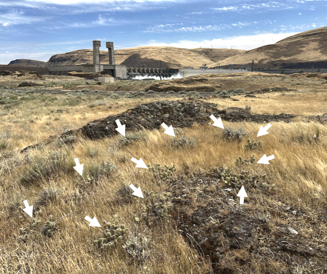
Part of the surprising Columbia Prickly Pear colony at Cliffs Park (John Day Dam in the distance). Each arrow marks a separate patch

Then, just as I was getting ready to leave the Cliffs Park colony, I came across one last patch of Columbia, Prickly Pear with a single blossom still hanging on. Fortunately, nobody was around to hear when I let out a whoop! I set up my camera and documented that lonely cactus blossom like no flower has ever been photographed. Ahab had finallyfound his whale!

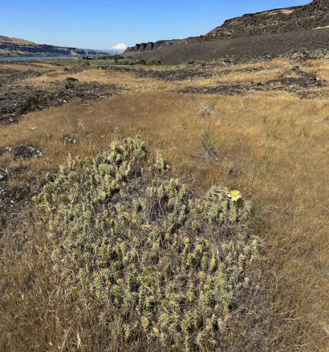
A straggler! One last Columbia Prickly Pear blossoms (center right) was hanging on for my visit to Cliffs Park in early June. And yes, a trifecta – snowy WyEast and the Columbia River are in the distance

Last of the Columbia Prickly Pear blooming at Cliffs Park in early June

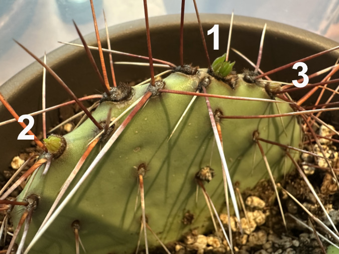
Though I missed most of the spring cactus bloom at Cliffs Park, there was plenty of evidence that it had been a good year, with ripening fruit throughout the colony. And while the blooms had been fairly scattered across the colony, there were also plenty of new pads that had developed over the spring, with new, soft spines that were still hardening into new armor.

Fruit forming beneath dried blossoms on Columbia Prickly Pear at Cliffs Park

The Columbia Prickly Pear colony at Cliffs Park is healthy, with several blooms and many new pads emerging this spring. In this view, four new pads have formed. They can be identified by their short spines that have yet to fully mature

It was already hot and dry at the Cliffs Park colony by early June, so these plants won’t get much moisture until well into September, putting their unique water storage ability into use, once again. 

Columbia Prickly Pear at Cliffs Park ready for the summer dry season. This plant has added just one new pad this season (lower right), illustrating how slowly these plants grow in their harsh environment

While the rest of the desert goes dormant until the rains return, these unique plants will remain green and producing food for their root systems throughout the summer and their spines will help protect them when most other forage is long dried up in the desert landscape. This is the genius of their evolution.

They seem to like it on the rocks…

Learning that the Avery Landing cactus colony was an introduced species and not the native Columbia Prickly Pear we have at Seufert Park and Cliffs Park helped me understand the preferred habitats for both species, as they are quite different. 

The Desert Prickly Pear at Avery Landing is happy on flat or steep slopes, provided that it can grow in loose, sandy or gravely soils. The Gorge has plenty of this with deep Missoula flood deposits lining the river on both sides, sometimes hundreds of feet deep. 

Desert Prickly Pear at Avery Landing seem to prefer the loose benches of Missoula Flood sand and gravel that were left here by ice age floods

Desert Prickly Pear seem highly adaptable, some growing in flat areas and hollows, while others thrive in steep ravines and slopes

Sandy soils seem to be key to the flourishing Desert Prickly Pear colony at Avery Landing 

Colorful Missoula Flood gravels are mixed with the sandy soils at Avery Landing, another ingredient the Desert Prickly Pear seem to favor

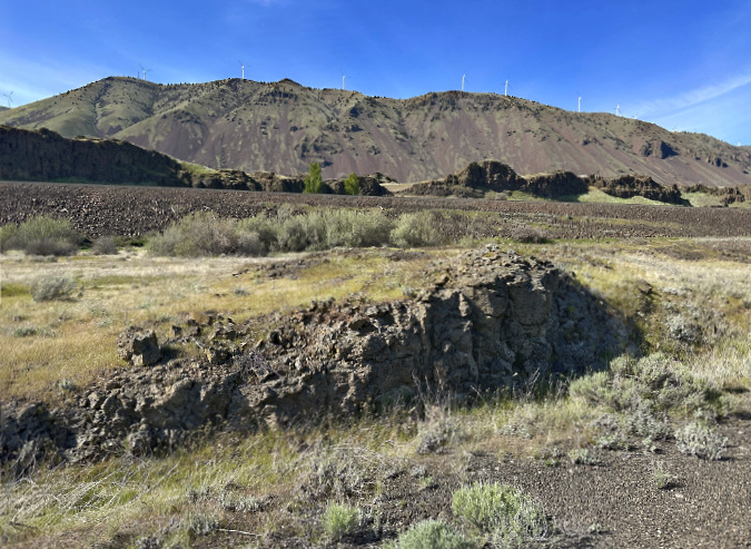
In contrast, the Columbia Prickly Pear colonies at Seufert Park and Cliffs Park are growing in loose scrabble directly on top of exposed basalt outcrops where the Missoula Floods scoured the bedrock. These are harsh places that seemed impossible for a plant to survive, yet our native Columbia Prickly Pear seems to prefer them. 

Columbia Prickly Pear at Seufert Park grow in thin, gravelly soils on a basalt bench above river. A second cactus patch in this view is shown with an arrow

This Columbia Prickly Pear at Cliffs Park is growing from a narrow crack in the basalt

This young Columbia Prickly Pear at Cliffs Park has somehow found a toehold on top of a basalt slab

This is especially apparent at Cliffs Park, where the colony is scattered across a low basalt table, despite being surrounded by deep soil deposits of gravel and sand on three sides.

The Cliffs Park colony favors the top of this dry basalt ledge over the deeper soils that surround it, perhaps because there is less competition there from other plants?

The best explanation might be simple competition, as the sandy areas with deeper soils support much more vegetation, including several wildflower species, where the basalt table is mostly limited to grasses, moss and lichen. Where a thin layer of soil has accumulated on the table, the Columbia Prickly Pear seem most at home. Their unique ability to withstand extreme drought also makes them uniquely able to grow under these harsh conditions.

Helping the Columbia Prickly Pear thrive?

While our Columbia Prickly Pear are not common, they are (fortunately) neither rare nor threatened. They’re just quite hard to find. That’s a shame, because they are unique and deserve to be more widely known and appreciated. This article was written in that spirit (including some general directions for finding them, below). 

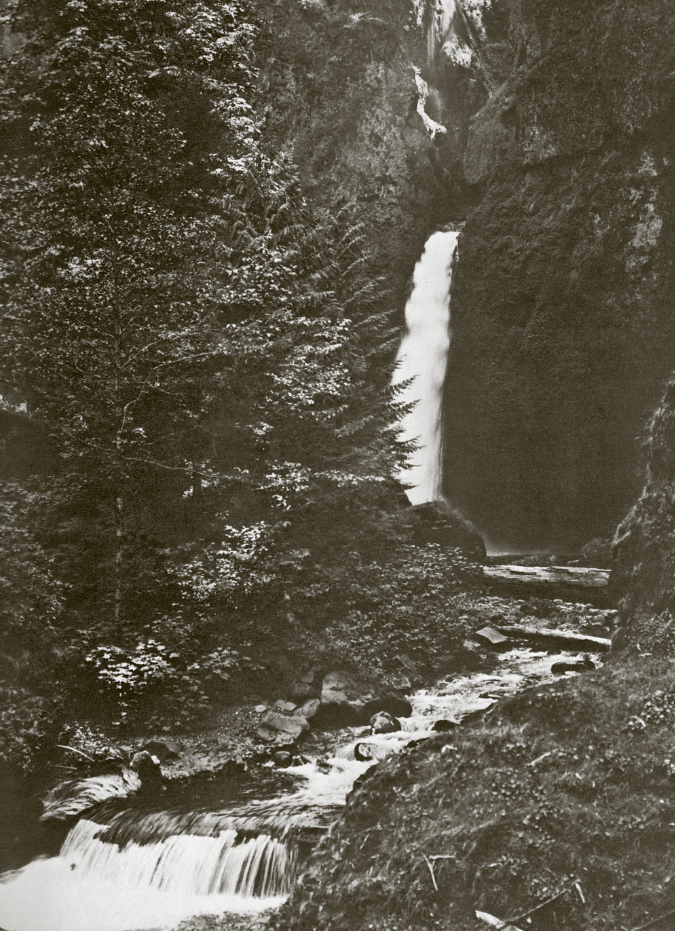
Were Columbia Prickly Pear much more common in the Gorge when Benjamin Gifford took this photo in 1899 at today’s Cliffs Park? I think so…

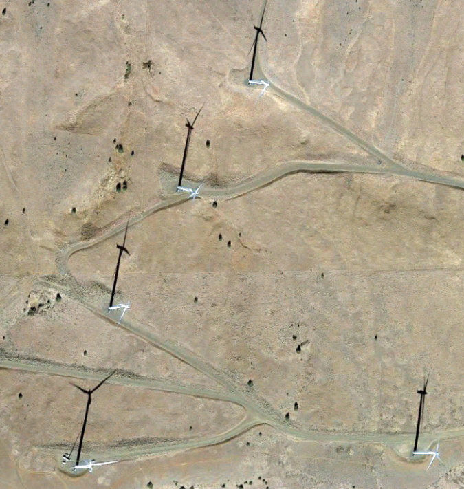
Why are they so uncommon? My theory as to their present scarcity is simply the wear and tear on the Columbia Gorge since the era of white settlement began nearly 200 years ago. Heavy grazing, first by sheep, then cattle, surely had an impact. Railroad, highway and dam construction followed, and – most recently – windmills. All disrupted our native flora and fauna. Unlike most other wildflowers, cactus are slow growers, and I suspect they are simply more vulnerable to frequent disturbance. This might be another explanation for colonies living atop rocky basalt outcrops where not much else survives.

To help remedy this state of affairs for our Columbia Prickly Pear in a small way, I’ve taken on a project that I thought I’d share here. 

The oddly small number of our native cactus in their native landscape inspired me to try propagating them with the intent of starting some new colonies. My (perhaps half-baked) plan is to offer them to public land managers in the Gorge interested in to establishing new Columbia Prickly Pear colonies in a few new spots of similar habitat along the river – of which there are many.

With that goal in mind, I had collected some pads at Avery Landing last winter for propagating before I knew these to be a different species than our native Columbia Prickly Pear. They rooted nicely, but now they will be donated to a garden in Portland – not the Gorge. 

Prickly Pear propagate readily, even from the somewhat withered, bedraggled state of these Desert Prickly Pear cuttings in March

By May the Desert Prickly Pear starts had plumped up from their withered state, showing they had quickly grown new roots. Soon, they began pushing out buds for new pads just two months after I planting. Three new buds are numbered here

By early July, the Desert Prickly Pear cuttings were fully rooted and forming new pads

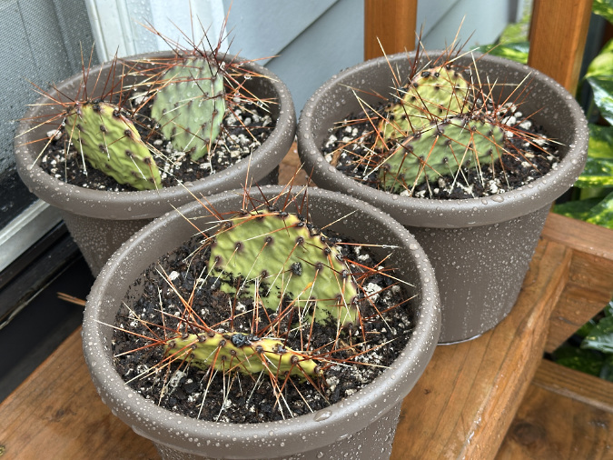
More recently, I collected some pads from our Columbia Prickly Pear. I’m hoping to root them over the summer and offer them to any interested public land managers, especially state parks. Collecting the pads was simple and discreet – as in, I left no trace. The tools involved a pair of kitchen tongs, a paring knife, leather gloves and a paper grocery sack (as I said in my opening, I’m a cactus fanatic, and growing them is in my wheelhouse!). Once harvested, I gave them a few days for the cut to form a callous before planting them in a 50/50 mix of potting soil and perlite.

Columbia Prickly Pear pads collected for propagation in mid-June

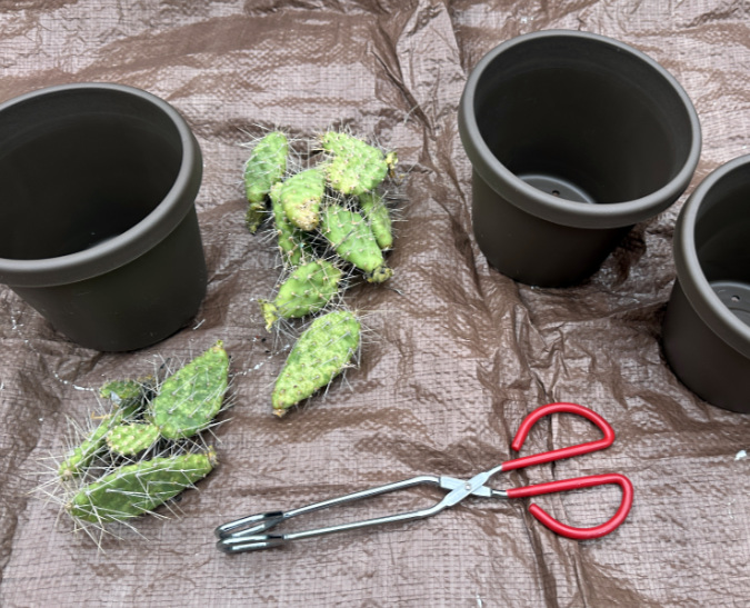
Columbia Prickly Pear pads ready for potting in mid-June

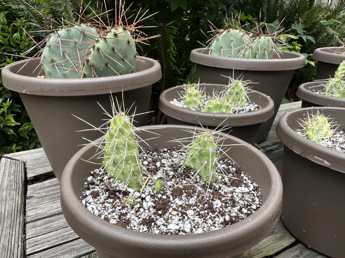
The Columbia Prickly Pear nursery in the foreground (smaller pads with yellow-green coloring and white/grey spines) is clearly different in this side-by-side comparison to the much larger Desert Prickly Pear starts (in back, with blue-green pads and red/brown spines) 

And then there’s the little cactus shown below. As I was exploring the colony at Cliffs Park, I found this seedling growing on the gravel shoulder of the park road, just a few inches from the asphalt pavement. I had nearly flattened it when I parked on the shoulder! It was clearly doomed there, so thanks to a small trowel I carry my trail car, this little rescue is now growing happily in a pot, waiting to be planted in some permanent location where it might start a new colony.

The little rescued cactus also gave me a good look at their root systems in the wild. They are surprisingly shallow-rooted! It makes sense when you consider their ability to store water in their pads, and their preferred habitat in shallow, rocky soils.

The Cliffs Park rescue cactus gave me my first look at the surprisingly small root system these plants have in the wild

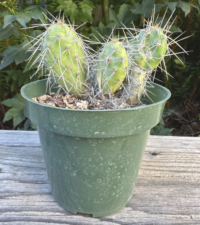
The Cliffs Park rescue cactus potted and growing in his (her?) new home for a while

I don’t have a specific plan for this project beyond propagating a few plants, but my lifelong cactus obsession would not let me do otherwise. I just think that more people should see these amazing plants in places where they likely used to grow in the East Gorge, before white settlement.

Should you propagate these plants? It’s perfectly legal to take cuttings, so if you own property in the East Gorge with the right habitat and are looking to add native species, yes. You would be helping this unique species thrive. Otherwise, simply admiring them in the wild is the best plan. They don’t make for great ornamental cactus for urban settings compared to the many cultivars out there that have been bred for our gardens.

Where you can see them…

If you are interested in seeing cactus growing right here in the Columbia River Gorge, the colonies at Avery Landing and Cliffs Park are very easy to visit. Both bloom from mid-May into early June. Like many cactus species, the blossoms seem to open during the middle of the day and into evening, so afternoons are the best bet for a visit. However, they are fascinating plants to see any time of year, not just during the blooming cycle.

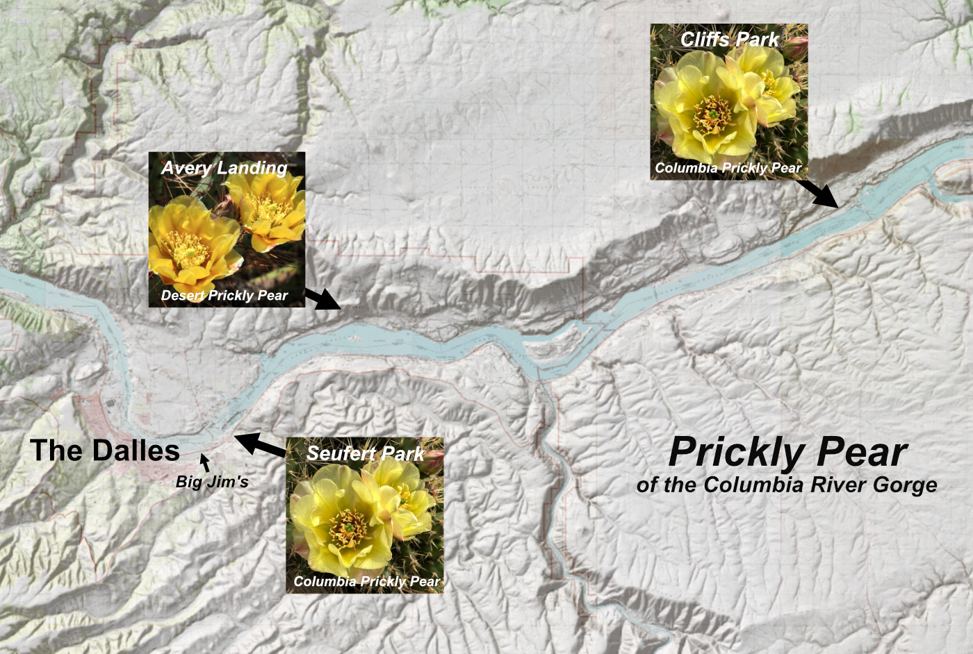
The Columbia River Gorge Prickly Pear tour begins in The Dalles (and ends at Big Jim’s for a milkshake, of course)

[click here for a large, printable map]

While the Avery Landing colony of Desert Prickly Pear are not native, they are beautiful and grow in a spectacular setting. Most of the colony grows along an old road grade that splits off the paved access road to the park. Watch for it heading off to the right just past the winery at the top of the hill. If you cross the railroad tracks, you have gone too far. Here’s a view (below) of the road grade looking back toward the park road and winery – you can park where I did.

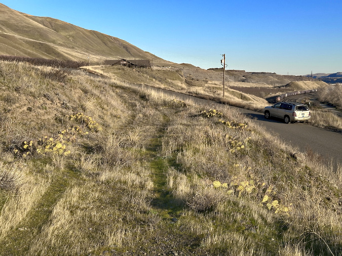
Looking east along the old road grade that is home to a large Desert Prickly Pear colony

Part of the Avery Landing colony is on private land, and clearly defined as such with the fence gate. Please respect private property rights. 

To see our native Columbia Prickly Pear, you can visit them along the paved access road to Cliffs Park, located on the Washington side of the river at John Day Dam. Follow the road into the park, and pull off just before it turns to gravel. Here’s a wayfinding photo – watch for these signs and pull off just beyond them. The cactus colony is on the low basalt bench just ahead, on the right (north) side of the road.

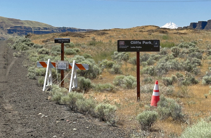
The Cliffs Park colony is located on the low, rocky bench directly beyond these park signs

Walk slow and carefully to avoid stepping on them – both for your benefit and theirs! And as with any desert hiking, watch your step for rattlesnakes, too. While you’re not likely to see one, they do like to bask in late morning and early afternoon in rocky areas like this.

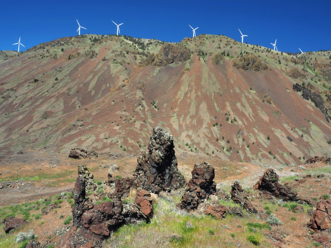
The towering backdrop to the Cliffs Park colony are the sacred bluffs that I described in this article (you’ll need to scroll down). This is the area where a proposed energy project is being contested by area tribes and many other groups. 

If you’d like to learn more about the controversial project from the perspective of the Rock Creek Band of the Yakama Nation, a powerful new documentary called “These Sacred Hills” is currently being screened around our region.  https://sacredhillsfilm.com

The sacred hills rise above the Cliffs Park colony of Columbia Prickly Pear

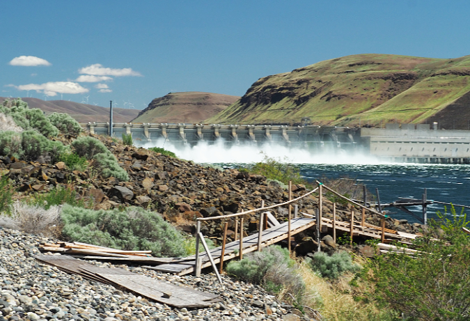
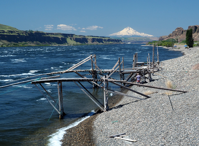
While you are at Cliffs Park, consider traveling a bit further down the gravel road to visit the expansive pebble beach composed of Missoula flood deposits. Mount Hood floats on the horizon, making this one of the most beautiful spots on the Columbia River.

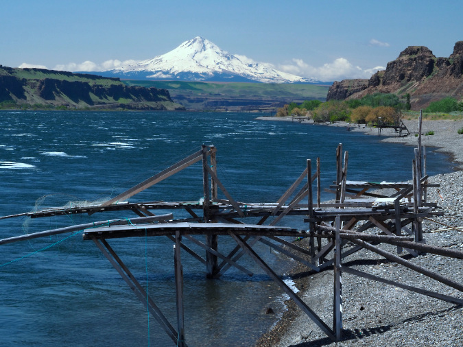
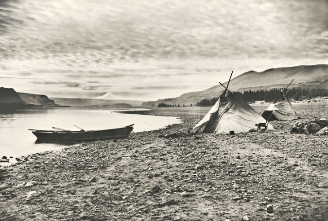
Mount Hood rises above traditional fishing platforms and the vast beaches of Missoula Flood rocks at Cliffs Park

This is a traditional Indian fishing spot, and you will see several fishing platforms here. The park is open to everyone, but please respect the tribal fisheries and the native fisherman who may be working here. I personally choose not to photograph indigenous people fishing, even on public lands.

I did not include Seifert Park on this itinerary for a couple reasons. First, the cactus here are harder to find than those at Avery Landing and Cliffs Park. Also, while it is public land and open to anyone to explore, the park also includes treaty-protected tribal fisheries. If you do go there, please respect the rights and privacy of the tribes. 

These rocky outcrops are home to the Seifert Park colony of Columbia Prickly Pear, but they are also protected tribal fisheries. Please be respectful if you explore here

To see our little Columbia Prickly Pear cactus growing in the most unlikely of places gives a sense of the timelessness of nature, despite these colonies being surrounded by transmission towers, the noise of the dam spillways, railroad and highway traffic and the bones of abandoned industries. While the hand of man has not been kind to these areas, the resiliency of nature is truly impressive and inspiring. 
_______________

Tom Kloster • July 2025

Tanner Creek Landslide at 50 years

Beautiful Wahclella Falls in the massive rock cathedral that Tanner Creek has sculpted

Fifty years once seemed like a very long time to me – half a century! Fifty years before I showed up on this planet (in 1962) human flight had barely been mastered and automobiles had just begun to replace the horse and buggy. Looking back today upon the past fifty years, things seems less changed from the perspective of a 61-year-old (though it’s true that without the arrival of personal computers and the internet, I wouldn’t be posting this article!) Our sense of passing time is warped by our own very short lives.

That’s the gift of witnessing the natural world around us moving forward at its own pace, as it has for millennia. Fifty years is a fleeting moment in time to our mountains and forests, where the only constant is change and the seemingly endless repetitions in the of cycle life that plays out on the landscape. Seeing these larger systems at work is a reassuring escape from our daily lives driven by deadlines and chores, and a reminder of the larger natural order that we belong to.

Tanner Creek weaving through the mossy boulder gardens below Wahclella Falls

This article is a 50-year snapshot of a catastrophic landslide in the Columbia River Gorge that perfectly illustrates these forces at work, right before our eyes. The landslide took place in the lower gorge of the Tanner Creek canyon in 1973, triggering a cascade of events that are still playing out today. It might have gone unnoticed at the time by all but a few avid hikers had there not been an earlier human presence at Tanner Creek dating back to very start of the 20thcentury. 

The story begins at the Bonneville Fish Hatchery, located at the mouth of Tanner Creek. Built in 1909, it remains as one of the oldest hatcheries in the State of Oregon’s system, and was established as a place to breed salmon fry to be shipped to other hatcheries around the state.  The map below shows the proximity of Tanner Creek to the Columbia River, Bonneville Dam and today’s Interstate 84.

The Tanner Creek gorge is located on the south side of the Columbia River at Bonneville, in the heart of the Gorge

The Bonneville Hatchery opened five years before the Historic Columbia River Highway arrived at Bonneville, when Gorge travel was still by train or boat. It was completed nearly 30 years before Bonneville Dam was constructed, though expanded as part of the dam construction project. Over its nearly 125 years of operation, The Bonneville Hatchery has been expanded and upgraded several times in an attempt to keep pace with continued dam building upstream on the Columbia River. The hatchery continues to be a popular tourist attraction, with stocked ponds and interpretive displays.

Construction of the hatchery diversion dame on Tanner Creek in about 1907 – note two men standing on the pipeline intake structure (OSU Archives)

The hatchery diversion dam today

The Bonneville Fish Hatchery originally depended on the cold, clear mountain water of Tanner Creek for its existence. When the hatchery was constructed in 1908, a small diversion dam was built one-half mile upstream from the main hatchery and a supply pipeline was built along the west bank of Tanner Creek to carry stream water to the hatchery ponds. The original diversion dam still exists today, though most of the hatchery water now comes from wells. The old pipeline has since been replaced, and is now buried under the short access road that hikers follow to the old dam and the start of the Wahclella Falls trail.

The original pipeline that carried Tanner Creek water to the Bonneville Fish Hatchery nearing completion in about 1908

Today’s access road to the diversion dam replaces the old water supply pipeline, and doubles as the first half mile of the Wahclella Falls Trail. This view is in roughly the same spot as the previous historic photo

When the Tanner Creek landslide occurred in 1973, it was first noticed by hatchery workers after the water supply suddenly stopped flowing. An investigation upstream revealed a massive cliff collapse along the west all of the canyon, just below Wahclella Falls. The resulting landslide had completed blocked Tanner Creek, temporarily blocking the streamflow below the landslide.

There was a rough user trail to Wahclella Falls in the days of the landslide, but it was a sketchy affair, crossing several treacherous, small landslide chutes on the east side of the canyon. Hikers parked at a gravel turnaround by the access road gate (located at today’s Wahclella Falls parking area) to reach the trail. By the late 1980s, the modern trail we know today was conceived, with much of it built by volunteers. When the new loop trail was completed in the early 1990s, the landslide was deemed stable enough to be traversed by the new trail. This has allowed countless hikers over the past 30 years to see the spectacle close-up.

Hikers are dwarfed by the Tanner Creek landslide debris – especially the house-sized boulder in the middle of the debris field

Loose material from a landslide typically forms a steep, cone-shaped pile at its terminus, known as a debris fan. Today, the landslide debris fan from the 1973 landslide appears as a green, moss and fern-covered talus slope with a few young trees gradually becoming established in the rubble. A few truck and house-sized boulders poke through the surface of the smaller talus. Below the talus slope, Tanner Creek has stripped away much of the small debris, exposing several of these giant basalt boulders in a dramatic rock garden that the stream continues to shape and shift.

What caused the landslide?

Three epic geologic events continue dominate how the Gorge is shaped today, including the 1973 landslide at Tanner Creek and the many smaller cliff collapses and landslides that occur every year. The first event created the underlying geology of the Gorge, and dates back about 17 million years. On the Oregon side of the river, ancient layers of volcanic ash and debris (similar to what Mount St. Helens produced in the 1980 eruption) accumulated to form the loosely consolidated geologic foundation, and is visible at river level. This unstable base is known as the Eagle Creek Formation.

The second event occurred between 12 and 16 million years ago, when hundreds of epic lava flows originating near today’s Steens Mountain flooded much of Oregon, leaving behind thousands of feet of “flood basalts” in stacked layers. These are collectively known as the Grande Ronde Formation and make up the layers we can plainly see in the towering cliffs that make dominate the Gorge landscape today. For this article, they will simply be referred to as Columbia River Basalt. 

Thick layers of ancient Columbia River Basalt make up the steep walls of Tanner Creek canyon and much of the surrounding Gorge landscape. Individual basalt layers can range from a few feet to 50 feet or more in depth

The underlying ash and debris layers of the Eagle Creek Formation are less obvious than the overlying basalt, but this formation is familiar to hikers. Named for Eagle Creek in the Gorge, hikers slip and slide during the wet months on the muddy trail surface where the first mile or so of the famous Eagle Creek Trail is built across this material. 

Compared to the hard, black layers of basalt that form the bulk of the overlying geology, the Eagle Creek formation is very unstable, especially when exposed to weathering or stream erosion. And though the overlying layers of basalt are comparatively hard and durable, their weakness comes from the extensive fractures that form when basalt lava flows cool, creating the familiar columns that are common throughout the Gorge (more about that weakness in a moment).

Loosely consolidated volcanic avalanche debris known as the Eagle Creek Formation underlies thousands of feet of basalt layers in the Gorge, making for an unstable, easily eroded foundation

Eagle Creek Formation makes up this wall along the lower section of the Tanner Creek Trail

The third epic event came long after the volcanic ash and lava had cooled and at the end of last ice age. During a period from about 13,000 to 15,000 years ago, a series of catastrophic floods from collapsing glacial lakes in today’s western Montana and northern Idaho and Washington rushed across the landscape of the Columbia Basin, then pushed through the Columbia River Gorge toward the Pacific Ocean. Compared to the volcanic episodes that created the Eagle Creek Formation and Columbia River Basalts, the glacial floods occurred yesterday, by geologic standards, and their impact is still playing out today.

The floodwaters were an astonishing 800 to 1000 feet deep as they rushed through the Gorge, carving the steep, dramatic gorge we know today. These are now known as the Bretz Floods, and scientist now believe there were over 40 separate flood events over the course of this period. The floods named for Harlen Bretz, a brilliant, visionary geologist who bravely persevered against intense criticism of his theory behind these events before they were finally accepted by the scientific community in the 1960s and 70s.

The trademark waterfalls of the Gorge are a product of the Bretz Floods where the stacked layers of ancient flood basalts were stripped of loose slopes and debris, revealing the soaring, vertical cliffs and dramatic waterfalls we see today. Where these waterfalls occurred on larger, more powerful streams like Tanner Creek, time and constant erosion has gradually migrated them upstream and away from the Columbia River over the millennia.

The succession of massive ice age floods known as the Bretz Floods easily topped Crown Point, stripping away all but the basalt cliffs, just as the floods shaped the sheer cliffs we see throughout the Gorge today

Since the great floods, Tanner Creek has persistently swept away debris from each successive landslide and cliff collapse, continually eroding the heavy basalt layers from below and setting the stage for the next landslide event. The underlying Eagle Creek formation speeds up this process because it lies at river level in the Gorge, allowing both the Columbia River and its tributary streams to actively undercut the towering basalt walls that rest upon this unstable, underlying layer.

Today, Wahclella Falls marks the current spot where Tanner Creek continues to carve its own, ever-longer gorge, now more than a mile long from where it began after the floods. Seen in this timeframe, the 1973 landslide at Tanner Creek was just one event in hundreds of similar cliff collapses and landslides over time that continue to shape the Gorge we know today. 

Weathered basalt often spalls according to the cooling cracks that formed when the lava flows cooled, creating the familiar stone columns common in the Gorge.

The cooling cracks in the basalt layers help, too, as they allow slabs of basalt to continually calve off where the cliffs have been undercut by erosion (see the photo, above). The cracks that form the columns in basalt also allow water to seep in when exposed to weather, and when the water freezes it expands, eventually splitting the rock. While most basalt columns are 5-sided, they may have anywhere from 3-7 sides or be less organized in their cooling patterns. As the example above shows, the columns typically break into pieces on impact when they fall, turning them into the smaller blocks of sharp-cornered basalt. When these blocks make it into a large stream like Tanner Creek, they are further tumbled and broken down into smaller pieces and moved downstream.

Whole chunks of basalt also split off when fractures in the rock are expanded by repeated freezing and thawing of water that seeps into the cracks. The raw, dark area at the center in this view just downstream from Wahclella Falls mark the spot where the boulders at the base of the cliff split off a few years ago. Moss will soon cover the evidence of this collapse.

The spalling process is underway on every sheer basalt face in the Gorge, and most of the steep talus slopes in the Gorge were created this way, gradually growing over time as new basalt chunks drop onto the rock slope from spalling cliffs above. This phenomenon occurs at scales both small and large throughout the Gorge, from individual columns spalling off to entire rock slabs and cliff faces that also break up into smaller pieces on impact. It was basalt wall collapse like this that triggered the 1973 Tanner Creek landslide.

The monumental crash nobody heard…

The sole known account of the 1973 landslide at Tanner Creek comes from Don and Roberta Lowe, legendary hiking guide pioneers in Oregon. Their first guide to trails in the Columbia River Gorge was published in 1980, and included this description of the event:

_________________

“In 1973, attendants at the Bonneville Dam Fish Hatchery were surprised, puzzled and alarmed when the water supply to the facility by Tanner Creek abruptly stopped. When the flow did not resume after a short time, the men became worried, as hatcheries require constant supply of fresh water, so they hiked up Tanner Creek to learn what had happened. 

“The canyon was filled with an eerie calm and almost unearthly ambience. A short distance before Wahclella Falls, they found the answer: several hundred cubic yards of the west wall had fallen away and blocked the stream, forming a small lake behind the dam. Fortunately, water began flowing through the debris before any damage was done in the hatchery. The lake (although not as large as it was soon after the landslide) and the slide area still can be seen from the trail – an intimidating view.”

-From “35 Hiking Trails: Columbia River Gorge” by Don and Roberta Lowe (1980)

_________________

The Lowe guide goes on to describe the very rustic trail to Wahclella Falls as it existed in the 1970s, a slippery boot path the Lowes describe as “tricky” during the wet season, including a rock-hop along Tanner Creek near the trailhead – a far cry from today’s well-graded, family friendly trail.

It’s hard to imagine what the scene must have been like when the basalt cliffs gave way along Tanner Creek in 1973, but it must have been extraordinarily loud! Dozens of massive, house-sized boulders managed to roll all the way to Tanner Creek, several hundred feet below, part of a huge debris fan that measures more than a quarter mile across. What we can’t know is whether it happened as a single event, or series of collapses over hours, or even days, though the complete damming of Tanner Creek – a sizable stream with a powerful flow — suggests a single, catastrophic event.

The temporary lake behind the landslide debris lasted long enough to make it onto U.S. Geological Survey maps that were being updated in the 1970s. The bare slopes of the debris fan were also shown on the new maps. Part of the lake persisted well into the 1980s, when I made my first trip into the canyon. Photos from the trip that I have included in this article show just how raw the landslide area continued to be more than a decade after the collapse.

The tiny, temporary lake resulting from the landslide was timed perfectly to be included on USGS maps. Tanner Creek has since carved through the landslide debris and the lake is no longer

The tiny lake on Tanner Creek persisted into the 1980s – this view is from 1986

In preparing this article, I searched for official accounts of the landslide event and historic photos of the west wall of the canyon from before the landslide, but found neither.  Therefore, the following schematics are based upon visual evidence on the surviving cliff face above the landslide and the sheer amount of debris that came down. It must have been involved a very large section of the canyon wall. Another guide for these schematics was the recent pair of cliff collapses at nearby Eagle Creek (described in this article), where the “before” conditions were well-documented could be easily compared with the amount to debris produced in these similar, though somewhat smaller events.

Visualizing the landslide aftermath

The first schematic view of the landslide is from high on the east slope of Tanner Creek Canyon, where the modern trail approaches a footbridge over a tributary stream (below). Wahclella Falls is just out of view to the left, and Tanner Creek can be seen in the lower left of this view. The dark cliffs on the left side of the photo were not involved in the collapse, so they provide a reasonable sense of what the west wall must have looked like before the 1973 collapse and landslide. 

[click here to open a large version in a new tab]

The dashed line shows the extent of the collapse, where the canyon wall gave way. Large, intact slabs of basalt that were once part of the wall poke through the loose debris of the fan, below. This is common when basalt cliffs collapse, as the amount of fracturing within the layers of rock determines whether the individual layers hold together in large chunks as they fall, or complete disintegrate into the loose talus rock that makes up most of the Tanner Creek debris fan. The arrows show the direction in which rock from the collapse tumbled, creating the debris fan we see today. The circled hiker on the lower leg of the loop trail provides a sense of scale against the massive slide area.

This schematic view (below) is from farther upstream on the main trail, just below Wahclella Falls and directly opposite the landslide. It provides a better sense of what the west wall might have looked like before the collapse, based on the intact wall to the left. The collapsed area is now a hollowed amphitheater in the wall of the canyon, and it still sends rocks and debris down to the fan each year as the new cliff face continues to weather and spall from exposure to the elements. The stand of mature Douglas fir to the right survived the event, marking the edge of the new debris, though these trees also grow on a talus slope created by some earlier event in Tanner Creek’s continued evolution. Two groups of hikers are circled to provide scale.

[click here to open a large version in a new tab]

Tanner creek can also be seen at the bottom of the schematic, where it tumbles through house-sized chunks of collapsed cliff that rolled into the stream during the event. At the time of the collapse, smaller, loose debris filled the voids between these giant boulders in the same way the large boulders remain buried in smaller material in the debris fan today. Tanner Creek quickly carved into the smaller material, clearing it away over the past 50 years and stranding the giant boulders in the creek bed. 

The next schematic of the landslide (below) is from the lower part of the loop trail, where it crosses the debris fan and where the hikers appear in the previous schematic. This view gives a better sense of the smaller debris, from small, loose basalt fragments to boulders ranging from a foot across to as much as 25 feet across. The amphitheater formed in the cliff wall is more evident from this perspective, as well.
Over the half-century since the collapse, this part of the debris field has settled into a talus slope and is now fairly stable where it is out of reach of Tanner Creek.

[click here to open a large version in a new tab]

Along with the moss and Licorice Fern that now carpet much of the talus in the debris fan, a few Douglas Fir have become established over the half-century since the collapse, along with scattered understory plants like Ocean Spray and Snowberry. Despite fifty years passing, however, the landslide remains a raw, rocky place that tells us the full recovery will take many more decades for the forest to fully reclaim this slope.

The following photo sequence shows the progressive forest recovery on the landslide from just 13 years after the event, when moss was just beginning to take hold, to 2011, when the east wall of the canyon had stabilized enough to become dense with young deciduous trees like Bigleaf Maple and Red Alder. The most recent view shows a thinned forest recovering from the Eagle Creek Fire that swept through in 2017, moderately burning several sections of the Tanner Creek canyon, including this slope. 

Forest recovery over the years on the Tanner Creek landslide

[click here to open a large version in a new tab]

The arrows in this photo comparison show common reference points, each marking one of four very large boulders that haven’t moved since the 1973 event. Surprisingly, the tall Douglas fir along the left edge of these photos is the same tree, and one that has survived the many changes to the area over the past half century – though leaning toward Tanner Creek a bit in recent years.

Why was the east wall of the canyon affected by a landslide on the west side? That traces to the dammed-up stream and subsequent erosion as Tanner Creek worked its way around the pile of debris the landslide had pushed against the east slope. As constant stream erosion has gradually uncovered the massive boulders that line the creek, the boulders have forced the creek against the edges of the stream channel, undercutting slopes on both sides of the canyon as the channel continues to deepen. 

The lower bridge on the Tanner Creek loop trail crosses the stream where soft Eagle Creek Formation is overlain by solid basalt flows and loose basalt debris

Though they seem immovable by their sheer size, Tanner Creek continues to gradually shift the giant boulders over time, as they lie directly on unstable Eagle Creek Formation that forms the creek bed. This soft, underlying formation can be easily seen from the lower footbridge (above) along the Wahcella Falls trail, with the collection of basalt landslide boulders resting on top of the formation where it has been exposed by the creek. As the creek erodes soft Eagle Creek Formation material under these boulders, they shift, which in turn shifts Tanner Creek, as well. This continually shifting action continues to actively undercut slopes on both sides of the canyon, triggering smaller active landslides in several spots. 

This effect can be seen in the following view of the east slope showing one of several small landslides that has been triggered over the years as the Tanner Creek banks against the foot of the east slope to move around the boulder in the lower right.

Active landslide on the east side of the canyon where Tanner Creek has been pushed against the slope, undercutting it

Over time, even house-sized basalt boulder fall apart, and this is on display at Tanner Creek, too. The giant boulder shown in this image (below) split sometime in the early 2010s. By 2016 a large piece had split off and partially crumbled, falling off into the stream in several pieces. While weathering like this typically results from cracks in the basalt that are expanded over time by freezing and thawing, the uneven erosion of the underlying Eagle Creek Formation likely destabilized this boulder further, with the sheer weight of the rock eventually pulling it apart at the seams.

This giant boulder was split apart in the early 2010s when Tanner Creek eroded the Eagle Creek Formation material underneath

This comparison view (below) of the boulder in 2011 and 2016 shows the extent of the weathering that occurred, as well as how the collapse of the east portion of this boulder allowed Tanner Creek to more aggressively undercut the east slope of the canyon, behind the boulder, expanding an active landslide. The letters in this graphic mark reference points for comparing the views. 

Split boulder comparison from 2011 and 2016

[click here to open a large version in a new tab]

This animation (below) of the same before and after views of the boulder give a better sense of how the adjacent slope on the east wall was destabilized when the boulder split, leaving the slope unsupported and exposing it to undercutting by Tanner Creek. This weather and erosion sequence might seem unusual to us, but it is a constant in the geologic shaping of the Gorge, playing out countless times along Tanner Creek and along other streams that continue to carve their way through layers of basalt.

Animated split boulder comparison from 2011-16

The 2017 Eagle Creek Fire introduced yet another erosional force to the Gorge streams by producing thousands of fallen trees that quickly became driftwood as they fell or were carried downhill by landslides. During high water season, Tanner Creek and other large streams in the Gorge are fully capable of moving mature logs down their course, often piling them in huge log jams along the way. In a powerful stream, these join with the current when the streams are raging to become battering rams and pry bars against the boulders they encounter along their path.

Tanner Creek is especially wild and wooly in the winter, easily capable of moving whole logs down its channel

Such is the case at Wahclella Falls, where an enormous jam of several hundred logs has piled up since the fire in the side channel just below the falls (next to the “Wahclella Cave”). These comparison photos (below) shows how dramatically the log jam has grown over subsequent years, from a 25-foot wide pile two years after the fire in 2019 to a 120-foot long pile just five years in 2022. A smaller logjam has since formed inside the splash pool, as well (indicated by the arrow near the falls in the second photo). 

Despite the size of these log piles, they are temporary and will eventually be on the move. Their next stop will be the boulder garden created by the landslide, just out of view to the left, where they could significantly alter the changing stream channel there, once again.

Growth of the post-Eagle Creek Fire logjam at Wahcella Falls

[click here to open a large version in a new tab]

This view (below) of the main logjam at Wahclella Falls is looking downstream from the upper footbridge and shows the obstacle course of huge landslide boulders in the distance that these (and other) logs will eventually work their way through. When logs form a jam, the combination of their sheer weight and the water pressure building behind them can move very large boulders or simply divert Tanner Creek in a way that accelerates erosion under boulders resting in the streambed.

Post-fire logjam below Wahclella Falls

This view (blow) of the smaller logjam inside the Wahclella Falls splash pool shows these forces at work, with Tanner Creek continuing to add new logs and woody debris to the gap between these large boulders, where the stream once freely flowed. The hydraulic pressure behind these jams is immense during high water, allowing the logs to incrementally pry even large boulders like these loose, and thus rearrange the stream channel.

Smaller logjam within the Wahclella Falls splash pool

Logjams like these will continue to appear and grow for decades to come in the post-fire period in the Gorge. The very good news is that woody debris like this is an essential ingredient to healthy fish habitat for salmon and steelhead, a fairly recent discovery by stream biologists. The lack of fire in the Gorge over the past century has had the effect of starving streams of woody debris, so the new conditions that we are witnessing are, in fact, very old. This is what these streams had always looked like for millennia, before fire suppression began in the early 1900s.

What about the boulders at Wahclella Falls?

In writing this article, I’ve attempted to map the areas impacted by the 1973 landslide, including the many large boulders left behind in Tanner Creek. Without photos from before the slide, I’m not able to fully answer whether the iconic boulders immediately below the falls (as seen in the logjam comparisons, above) were part of the event, as some believe. However, I’m fairly certain they were not, and instead that they came from earlier, similar cliff collapse events long ago.

I do have a single historic photo of Tanner Creek (below), titled “Tanner Creek Falls in 1910”. If this is an image from a century ago, then it shows most of the boulders located immediately below Wahclella Falls to have been in place long before the 1973 landslide. The timing of the photo corresponds to construction of the Bonneville Fish Hatchery and accompanying diversion dam on Tanner Creek, so there’s a good chance it was captured during that period of intense activity in the area.

Wahclella Falls in 1910

While the 1910 photo doesn’t show much of the surrounding landscape, it does show the edge of a very large boulder that guards the west approach to the falls, immediately adjacent to the modern trail. The following comparison shows the edge of the same boulder on the right, as well as a pair of boulders in front of the falls that also appear to date back to the 1910 photo. 

Wahclella Falls over the course of a century – 1910-2015

[click here to open a large version in a new tab]

The angle of the 1910 photo also suggests that the flat-topped “island” boulder bounded by the side channel (and now by the logjam) is where the photographer was standing, since the rock in the lower right foreground of the 1910 photo is where the west end of the footbridge is located today. This is shown in the following image of the boulders surrounding Wahclella Falls, with at least four of these present at the time of the historic photo. 

Are these boulders from the 17973 cliff collapse? Unlikely

Based on the shape of the debris fan (just out of view to the left in the above photo), I believe all of the large boulders in this view pre-date the 1973 cliff collapse and landslide, though I will continue to look for historic photos that can document what really happened!

After the fire… and the future of Tanner Creek?

Since the fire in 2017, landslides have been active throughout the Eagle Creek Fire burn area. With no forest cover to moderate runoff, tributary streams flood more frequently, and as the killed trees begin to decay, their roots will no longer hold the steep Gorge slopes in place. Fortunately, the forest is already bouncing back, and these erosion effects will eventually fade, but in the meantime slides and erosion will continue to have a real impact – especially on hiking trails.

Small post-fire landslides like this one on the Wahclella Falls trail are keeping trail volunteers busy throughout the Gorge

What is less known is whether the loss of forest cover will trigger much larger events – like the massive cliff collapse that occurred at Punch Bowl Falls on Eagle Creek shortly after the fire. Given the amount of earth movement already happening on a smaller scale throughout the burn, it does seem likely that something larger might also be triggered. Perhaps this will happen at Tanner Creek? So far, there’s no way to know or predict future events of this scale.

Larger landslides like this one on the Wahclella Falls trail are moving whole trees burned in the fire into the stream

Meanwhile, Gorge visitation has never been greater, especially in the years after the pandemic, when interest in hiking soared across the country. At Tanner Creek, the combined effect of post-fire erosion and record crowds year-around has taken a visible toll on the landscape. Though the area was added to the Mark O. Hatfield Wilderness in 2009 to better protect it, Tanner Creek feels more like the popular state parks in “waterfall alley” on busy days than a “wilderness”. Large groups that greatly exceed the wilderness party limit of 12 are commonplace, and the small parking area at the trailhead overflows year-round, with cars parked along the freeway off-ramp on especially busy weekends.

Weekend crowds at the upper footbridge on the Wahclella Falls trail

For its part, the Forest Service has expanded amenities somewhat at the trailhead, including a growing collection of portable toilets and even periodic law enforcement visits in response to frequent car break-ins. So far, the hiking experience remains exceptional, despite the crowds and their visible impacts. The trail to Wahclella Falls is considered family-friendly, so many of the visitors here are children who (hopefully) will come back to this as their own cherished spot for decades to come. That is perhaps the best way to ensure places like this are well-cared for in the future.

Contractors servicing the array of portable toilets at the Wahclella Falls trailhead

In addition to the parking area basics like toilets, I would like to see more interpretive information on the 1973 landslide provided at Wahclella Falls. The wilderness designation means that any signage along the trail must be minimal and rustic in design, but there is plenty of space at the parking area or the formal trailhead near the hatchery dam to provide more information on both the unique natural history of the area and a simple map of the trail – many hikers I encounter here don’t realize it’s a loop, and I finding them standing puzzled at the unsigned loop junction, unsure of which way to go (“take the lower trail, it’s a loop” I tell them).

Lines form for selfie photos in front of Wahclella Falls on busy days

Looking to the broader future, my hope is that new trails and destinations will be opened in the Gorge to take some pressure off places like Tanner Creek. I’ve posted some ideas here over the years, and I will continue to make the case for more trails (including expanding the trails at Tanner Creek to new destinations upstream… watch for a future article on that topic!)

I’ve been hiking in the Gorge since I was in kindergarten, so I have the benefit of seeing the many changes to the area over time – whether they be natural events like the Tanner Creek landslide, or human-caused. That’s why this quote in the 1980 Lowe field guide caught my eye:

_________________

“The serene glade of cedar at the base of the Wahclella Falls is ample reward for the precarious stretches. You’ll probably want to spend extra time enjoying the sylvan setting.”

_________________

This description then came to mind when I was preparing this article, and ran across an image (below) from a hike to Wahclella Falls some 21 years ago, taken with my first digital camera in the fall of 2002. It was truly “serene glade” back then, and it still is – despite some signs of overuse that have since appeared.

Wahclella Falls in 2002 when the impact of hikers was still minimal

We don’t know what the forces of nature have in store for Tanner Creek in coming years, but the landscape continues to be in a state of dynamic change fifty years after the great landslide in 1973, and it will continue to change. But as the landscape continues to recover from the landslide – and now, the 2017 fire – we can do our part to ensure that this remarkable spot continues to be a place where we can watch the recovery unfold while also managing our own impacts, and allow some of the scars humans have caused to heal, as well.

________________  

Tom Kloster | November 2023

In the Realm of St. Peter

St. Peters Dome rising above the January 13 Bucher Creek debris flow that swept across I-84, killing one person (ODOT)

It seems a world away as we enter yet another summer drought, with record-breaking heat waves and an early wildfire season in WyEast country. Yet, just a few months ago, on January 13th, the tragic story of a Warrendale Resident being swept away in her car by a winter debris flow in the Columbia Gorge filled our local news. The event closed a 10-mile section of I-84 from Ainsworth State Park to Tanner Creek and the area was evacuated after the National Weather Service issued a flash flood warning. 

Some of the local media coverage also connected the dots, reporting on the long history of dangerous debris flows in this part of the Gorge. This was not a freak tragedy, but rather, a completely predictable event. The well-known hazard zone stretches from Ainsworth State Park on the west to Yeon State Park, five miles to the east, encompassing the hamlets of Dodson and Warrendale in its path. While the steep walls throughout the Gorge are infamous for producing rockfall and landslides, this stretch is notoriously active. Why?

Slip-sliding away…

Geoscientists don’t have a particular name for this geologically active area, but the unifying feature is a near-vertical wall that I will call the Nesmith Escarpment for the purpose of this article. The name that comes from Nesmith Point, which has the distinction of being the tallest feature on the Gorge rim, rising nearly 4,000 feet from the banks of Columbia River. The Nesmith Escarpment was largely created by the ancient, catastrophic Missoula Floods that shaped much of what we know as the Columbia River Gorge during the last ice, more than 13,000 years ago. These floods repeatedly scoured the Gorge with torrents hundreds of feet deep, often enough to overtop today’s Crown Point and Rowena Plateau.

Tumalt Creek is the largest of the volatile streams that flow from the towering, over-steepened Gorge walls of the Nesmith Escarpment(ODOT)

As the massive Missoula Floods cut into the slopes below Nesmith Point, the over-steepened terrain began to collapse into the river. It’s a process that continues to this day, gradually expanding the escarpment and leaving behind sheer basalt towers of resistant bedrock along the lower slopes. Of these, St. Peters Dome is the most prominent, along with Rock of Ages and Katanai Rock (the informal name for the impressive monolith that rises just east of St. Peters Dome).

The headwaters of Tumalt Creek flow from the highest walls of the Nesmith Escarpment, where the red, volcanic layers of the Nesmith Volcano that rests on the Gorge rim have been exposed by erosion  (ODOT)

Adding to the geologic uniqueness of the Nesmith Escarpment is Nesmith Point, itself. Located at the top of the escarpment, the familiar layer-cake stack of basalt flows that make up so much of the Gorge geology gives way at Nesmith Point to bright red and yellow layers of clay and cinders that reveal the uppermost part of the escarpment to be the remains of a volcano. The northern half of the volcano has been torn away over the millennia by the growing escarpment, leaving a visible cross-section of the volcanic dome. The surviving, southern half of the Nesmith volcano is gently sloping, like other dome volcanoes that line the Oregon side of the Gorge (the familiar peaks of Larch Mountain and Mount Defiance among them).

[Click here for a large version of the schematic]

The result of all this erosion is a 3-mile-long amphitheater of collapsing layers of volcanic debris and basalt walls resting uncomfortably and over-steepened upon ancient sediments at the base of the cliffs that make for a slippery, unstable foundation. Rain, winter freezes and gravity will therefore continue to chip away at the escarpment for millennia.

Over the many centuries since the Missoula Floods, this relentless erosion has built a huge apron of what geoscientists call an “alluvial fan” at the base of the Nesmith Escarpment. This name describes the flood debris that accumulates where canyon streams prone to flash-flooding suddenly reach a valley floor, slowing and depositing debris over time. The resulting layers typically form a broad, gently sloped wedge shaped like a fan. For the purpose of this article, the fan at the base of the Nesmith Escarpment will be referred to as the Nesmith Fan

(Source: State of Wyoming)

(Source: City of Scottsdale)

One of the defining features of an alluvial fan is the erratic, constantly shifting course of the streams that create them. Because of their shallow slope and the accumulation of debris, these streams continually change course as they spread their loads of rock and gravel on the fan.

If the Nesmith Escarpment and debris fan were located in a desert environment, these defining features would be exposed and easy to see. But in the forested western Gorge, the dense rainforest vegetation quickly covers debris flows with new growth, often within five or ten years, making it hard to recognize how active the geology really is. It’s therefore easy to understand why settlements like Dodson and Warrendale were built upon on the Nesmith Fan, where the fertile ground and gentle terrain were friendly to farming and home sites. The spectacular cliffs of the Nesmith Escarpment simply provided a beautiful backdrop for these communities. Yet, it’s also an increasingly hazardous place for anyone to live.

The image below shows the Nesmith Escarpment and debris fan in a way that wasn’t possible until LIDAR technology was developed. LIDAR allows highly detailed images of topography even in areas like the Gorge, where dense forests cover the terrain. The LIDAR view shows the steep walls of the escarpment in stark relief, including the hundreds of steep ravines that have formed along the escarpment.

Lidar view of the Nesmith Escarpment and debris fan

The LIDAR view also reveals the alluvial deposits that make up the Nesmith Fan to be a series of hundreds (or even thousands) of overlapping debris flows from the roughly dozen streams that flow from the Nesmith Escarpment, each helping to gradually build the enormous alluvial fan. The wrinkled surface of the fan reveals the hundreds of flood channels that have developed over the millennia as countless debris flows have swept down from the cliffs above.

This view (looking east toward Dodson from Ainsworth State Park) shows the vulnerability of I-84 and the Union Pacific Railroad where they cross the 3-mile-wide expanse of the Nesmith Fan. The 2021 debris flows and flooding damage to the Ainsworth interchange can be seen at the center of the photo, where the interstate was temporary closed by the event (ODOT)

[Click here for a large version of this image]

During the very wet winter of 1996, a series of major debris flow roared down from the Nesmith Escarpment, sweeping cars off I-84 and closing the freeway for several days. A train on the Union Pacific line was knocked off its tracks and many home were damaged.

During the event, debris from Leavens Creek, near St. Peters Dome, swept toward the Dodson area, eventually engulfing the Royse house, which was located near the Ainsworth interchange. The scene was shocking, burying the home in debris that rose to the second floor and destroying outbuildings on the Royse farm. You can read Carol Royse’s riveting account of the event on Portland State researcher Kenneth Cruikshank’s excellent web page describing the 1996 debris flows here.

The Royse House in Dodson (with St. Peters Dome beyond) after a series of debris flows on Leavens Creek engulfed the structure in 1996 (The Oregonian)

The Royse home stood half-buried and visible from the freeway for many years, becoming a prominent reminder of the power of the Gorge. By the mid-2000s, a new forest of Red alder and Cottonwood had already enveloped the debris path and the Royse home, eventually obscuring it from view until the Eagle Creek Fire destroyed both the structure and newly established forest in 2017. 

The more recent debris flows in January of this year struck some of the same spots that were impacted in the 1996 and 2001 events. The Tumalt Creek drainage was once again very active, sending debris onto I-84 and closing the freeway. To the west, the Leavens and Bucher creek drainages also sent debris onto the highway and the site of the former Royse home.

As jarring as these changes are to us, this cycle of destruction, rebirth and more destruction has unfolded hundreds of times on the Nesmith Fan. It’s simply part of the ongoing evolution of the landscape.

How do they start?

Debris flows are a mud and rock version of an snow avalanche. They typically begin with oversaturated soils on steep terrain that suddenly liquifies from its own weight. Once it begins to move, the flow can incorporate still more oversaturated soil as it gathers speed, just as a snow avalanche triggers downslope snow to move. The steepness of the terrain is a key factor in how fast a debris flow can move, and on very steep slopes they can reach as much as 100 miles per hour, though they typically slow as the debris reaches the base of the slope and spreads out to form alluvial fans.

These towering twin cascades where Bucher Creek originates along the Nesmith Escarpment rival Multnomah Falls in height. The impossibly steep terrain here is the source of both the debris and sudden flash floods that have helped build the Nesmith Fan, far below (ODOT)

A heavy rain event can also trigger a debris flow by creating stream flooding that erodes and undermines stream banks, causing debris to slide from canyon walls. This form of debris flow is common in the larger canyons in the Columbia Gorge, but less so on the Nesmith Escarpment, where most of the streams are small and only flow seasonally. Here, it’s the steepness of the slopes and the unstable geology that makes the area so prone to debris flows.

Debris flows are different from landslides. A debris flow is typically quite liquid and fast moving, like cake batter being poured into pan. Landslides are typically slow, with a large mass sliding as a whole, like an omelet sliding from a skillet onto a plate. In the Gorge, landslides are common and mostly occur where the underlying geology is oversaturated and allows the overlying terrain to move. The upper walls of the Nesmith Escarpment are scared by hundreds of landslides, and in the right conditions, these slide can trigger debris flows that spread far beyond the landslide.

What about fires and logging?

A third trigger for debris flows is the sudden removal of the forest overstory. The big trees in our Pacific Northwest forests capture and hold a tremendous amount of rain on their surfaces that never reaches the ground, with some of the moisture directly absorbed by the trees and much of it simply evaporating. Clear cut logging removes this buffer, allowing much more precipitation to suddenly reach the soil, triggering erosion, landslides and debris flows. 

Logging roads are especially impactful by cutting into the soil profile on steep slopes and allowing runoff to infiltrate under the soil layer and destabilized soils. This is well-documented as a source of major landslides in heavily logged areas. Thankfully, most of the forested western end of the Gorge is protected from logging, including the Nesmith Escarpment (though early white settlers logged these areas of the Gorge extensively)

The 2017 Eagle Creek Fire has not only destabilized steep slopes throughout the burn by killing the protective forest cover, it also revealed the tortured landscape of braided flood channels on the Nesmith Fan once hidden under dense vegetation. This image from just after the fire shows a volunteer trail crew scouting Trail 400 where it crosses the fan. The route curves in and out of the dozens of channels and debris piles formed by past flood events

Fire can have a similar effect on runoff when the forest canopy is completely killed. This is why new research shows that attempting to log recently burned areas can have serious effects by disturbing newly exposed soils and worsening the increased erosion that would already result from fires.

In the Gorge, the 2017 Eagle Creek Fire burned most of the Nesmith Escarpment, raising serious concerns about the debris flow activity accelerating here in the coming decades. The debris flows earlier this year may have been the first major events to have been triggered as much by deforestation from the fire as by oversaturated soils. The following photo pair shows the extent of the burn on the Nesmith Escarpment, with the first photo taken just a few weeks before the fire in 2017 and the second photo taken in 2018, when the fire’s impact was clearly visible.

The January 2021 debris flow

The Oregon Department of Transportation (ODOT) has been making regular flights over the Eagle Creek Fire burn since late 2017 to monitor for potential flooding and landslides. While the main purpose of these surveys is to anticipate impacts on the highway, ODOT is also amassing an invaluable library of historic photos that document the fire and resulting geologic events in a way that has never been done before.

Their most recent flight includes photos from the January 2021 debris flows that tell the story in a way that words cannot match:

This view looking west toward the Ainsworth Interchange shows how Bucher Creek had completely covered the south half of the interchange and sent mud and debris flowing east on the freeway, itself. The 1996 and 2001 debris flows impacted much of the same area (ODOT)

A closer look at the 2021 debris flows where the Ainsworth interchange was overwhelmed with debris. A green highway sign marks what used to be a freeway on-ramp (ODOT)

Bucher creek briefly pushed the lobe of mud and debris in the lower right of this view directly toward the home in the first photo, before changing direction to the path the creek is following in this photo. This is a good example of how accumulated debris regularly forces the streams that carry the debris into new channels. (ODOT)

This view looking back at the Bucher Creek debris flow lobe shows just how close it came to the home and outbuildings shown in the previous photo (ODOT)

The view down Bucher Creek debris flow toward St. Peters Dome and the Columbia River from near the crest of the Nesmith Escarpment (ODOT)

Landslide in burned timber near the crest of the Nesmith Escarpment. This landslide fed debris directly into the Bucher Creek debris flow, and onto the freeway more than 3,500 feet below (ODOT)

What to do?

It’s tempting to wish away future geologic hazards by taking comfort from what we perceive to be more predictable past. After all, the modern Gorge we know has been evolving for more than 13,000 years, and long periods of slope stabilization have marked recent centuries. But can we count on periods of stability in a future that will be shaped by global climate change? 

Almost surely not. All indications are for more volatility in both weather and flood events like those that have built the Nesmith Fan. Recent evidence increasingly supports the reality that our landscapes are changing along with the climate. In a 2016 report on landslide risks by Multnomah County, the number of events escalated over the past 25 years, including at the Nesmith Escarpment (see table, below).

The best path for adapting to this reality and becoming more resilient in response to future events is to accept the ongoing risk from the Nesmith Escarpment. In the near-term, this means regularly repairing I-84 and the parallel Union Pacific railroad after flood events that will become increasingly common and disruptive. It also means installing early warning systems along these routes for the traveling public and commers, as well as the residents of the area who live in harm’s way. 

The 2021 debris flow along Tumalt Creek during this year’s series of flood events on the Nesmith Fan was a textbook example of why adapting in the near-term to protect existing infrastructure is a tall order. The following images show just how unpredictable and unmanageable this steam has become for ODOT.

Once Tumalt Creek reaches the foot of the Nesmith Escarpment and begins to flow across the fan, its course continually shifts and changes, making it very difficult to predict where each debris flow event might be headed (ODOT)

A single culvert (above) carries Tumalt Creek under the freeway and frontage road, but the Nesmith Fan is a maze of shifting streambeds by definition, making it nearly impossible to force streams to obey culvert locations (ODOT)

The channel carrying the debris flow on Tumalt Creek that overwhelmed the frontage road and I-84 in February later dried up, with the creek shifting to another channel after the flood (ODOT)

This screen was installed at another culvert that Tumalt Creek has swept through in past debris flow eventsl. While this device might keep small debris flows from overwhelming the culvert, it has no chance against the increasingly large debris flows that we can expect on the Nesmith Fan (ODOT)

This is the view from the frontage road looking upstream at the large, main culvert intended for Tumalt Creek – though it had shifted out of the channel when this photo was taken a few months after the February event. The flatness of the terrain on the Nesmith Fan is evident here, with no obvious stream chanel except for the grading and contouring by highway crews (ODOT)

Adapting to a new reality

In the long term, coping with debris flows also means facing some tough questions for those who live on the Nesmith Fan. For some, it’s a place where families have settled for generations. For others, it’s a dream home they’ve put their life savings into on the Columbia River in the heart of the Gorge. But for anyone who lives here, the risks are real and growing – as the death of a local resident in this year’s debris flows reminds us.

Across the country, climate change and rising sea levels are impacting millions of homes and businesses built in floodplains formerly classified as “100-year”, but now seeing regular flooding. In the past, the U.S. Government has provided public flood insurance for those living or operating a business in a flood zone, but the increasing frequency of catastrophic events in flood and hurricane-prone regions like the Mississippi Valley, Texas, Florida and Carolina coasts is pushing federal flood insurance premiums sharply up. This does not bode well for those living and working in hazard zones in the Pacific Northwest, including the rural communities scattered across the Nesmith Fan.

Notices like this will become a way of life for Nesmith Fan residents in coming years

In some places along the Mississippi Valley, the federal government has begun simply relocating homes, and even whole towns, rather than rebuilding them in harm’s way. Could this be a model for the Nesmith Fan? Possibly, though most of the private homes in the path of debris flows are not in the flood plain, and may not be eligible for any form of subsidized federal insurance or assistance, short of a disaster.

A more direct approach that could be taken at the state level is a simple buy-out, over time. Where flood-prone areas in other parts of the country might simply have value as farm or grazing land, the Gorge is a world class scenic area, and both public land agencies and non-profits are actively acquiring land for conservation and public use. As Gorge locations go, it’s hard to find a spot as spectacular as the Nesmith Fan and the escarpment that rises above it.

Already, the Forest Service and Oregon State Parks have acquired land on the Nesmith Fan for recreation and to provide habitat under the Columbia River Gorge National Scenic Area provisions, including at least two parcels with coveted river access. Permanent funding of the federal Land and Water Conservation Fund last year should also help jump-start public acquisitions in the Gorge that have stalled in recent years, and could help spur land owners considering their options.

Katanai Rock (left) and St. Peters Dome (right) rise above orchards at Dodson in this 1940s view from the old Columbia River Highway

Recent events are surely changing the dynamic for landowners in the Gorge, as well. Would some residents living on the Nesmith Fan be more open to a buy-out after witnessing the devastation of last year’s debris flows, knowing that more are likely to come in the wake of the Eagle Creek Fire? Probably. Others – especially the string of luxury homes along the Columbia River – might be more motivated by legacy, and for these folks, non-profit conservation trusts and easements could be a tool for transitioning private land into public ownership over time.

In the meantime, expect more flooding, debris flows and periodic closures of I-84 during the rainy months. And probably more fires in summer, too. This is the new normal in the Realm of St. Peter, after all, and it’s a cycle that will continue for all our lifetimes, and beyond.

Gorge Roundup: The Great, The Sad… and The Ugly

Do you take scenes like this in the eastern Columbia River Gorge for granted? Read on…

As we slowly emerge from a year of pandemic, three milestones in Columbia River Gorge news are noteworthy for those who love WyEast Country. What do they have in comment? In each case, the multi-layered governance (or lack thereof) in the Gorge continues to be a hurdle, even when the news is very good… or even great!

The Great: Mitchell Point Tunnel Project

For many years the Oregon Department of Transportation (ODOT) has been quietly moving toward actually replacing the legendary Mitchell Point “tunnel of many windows” with a new windowed tunnel. The new tunnel is along the bike and pedestrian trail that ODOT has been building to reconnect the original Historic Columbia River Highway, and construction began this spring. It’s a bold and visionary project, and another dramatic nod toward historic restoration along the old route. The former Oregon Highway Division destroyed the original tunnel in the 1966, when it was deemed a hazard to traffic on the modern freeway being constructed directly below, and it has been a dream for many to see it restored ever since.

The new 655-foot tunnel will have five arched windows, roughly patterned after the original Mitchell Point Tunnel. When completed, the tunnel will become the crown jewel of the larger Historic Columbia River Highway State Trail, a concept 35 years in the making, with just five miles of trail remaining to be constructed. When the last five miles are complete, the trail is destined to become a world-class cycling destination that will allow visitors to ride from Troutdale to The Dalles without traveling along the modern freeway.

The iconic Mitchell Point Tunnel was completed in 1915, but it was destroyed by freeway construction just 51 years later in 1966. It lives on in our collective memory as the greatest engineering marvel of the original Columbia River Highway

This 1920s view of the original Mitchell Point Tunnel from the Washington side of the Columbia River shows both west viaduct that led to the tunnel and the famous series of windows (on the left). Freeway construction at the base of the cliffs in the 1960s destroyed both the tunnel and viaduct

The new Mitchell Point Tunnel will enter the basalt walls of Mitchell Spur, the smaller, northern offshoot of Mitchell Point, proper, and connect the existing Mitchell Point Wayside on the west side of the spur to a future trail and historic highway alignment east of Mitchell Point. Between the two new tunnel portals, five windows will frame Gorge views and light the way for visitors, providing an experience similar to what early motorists enjoyed from their Model-Ts in the early 1920s.

ODOT has posted a video on YouTube with drone footage and more background on the new tunnel:

While the new tunnel is certain to draw visitors who simply want to walk its length and enjoy the views, it also offers a terrific opportunity to create loop hikes that build upon the existing Mitchell Point Trail. This steep and difficult to maintain route is more like a goat path, but has become an increasingly popular viewpoint trail as placed like Angels Rest become overwhelmingly crowded. The Oregon Department of Parks and Recreation (OPRD) has already adopted a new loop trail concept for the west side of Mitchell Point that also would provide a better graded approach to the summit, and a loop for those willing to return along the existing, very steep route. 

This ODOT rendering shows the planned approach to the west portal of the new Mitchell Point Tunnel from the perspective of the Historic Columbia River Highway State Trail, which currently stubs out at these cliffs (ODOT)

This rendering also shows the new west portal that ODOT is constructing for the new Mitchell Point Tunnel. A bump-out viewpoint (on the left) is also included in the design (ODOT)

This concept shows the design for five windows that will be incorporated into the new tunnel at Mitchell Point. ODOT describes the tunnel interior as “modern concrete”, so the exposed rock surface in this rendering and visible in the previous portal rendering may not be part of the final plan (ODOT)

This view shows the existing overlook at the Mitchell Point Wayside, where the paved trail stubs out at berm at the base of Mitchell Spur’s cliffs. The west portal to the new tunnel will enter the cliff visible just beyond the berm, at the right in this photo. The berm will be removed to extend the trail to the new tunnel portal.

The west portal design for the new tunnel preserves this relatively new (2013) overlook at Mitchell Point, already a popular stop for Gorge visitors

The new tunnel also offers a loop trail opportunity from the east side of Mitchell Point, with the tunnel providing a return to the main trailhead. Loop trails are popular with hikers because you get to see more scenery for your effort. But they can also be managed as one-way trails where crowds are a problem, greatly lessening the impact of passing hikers on heavily traveled trails. The OPRD plan for the Gorge also includes a loop trail concept for Angels Rest with this exact purpose in mind. From a hiker’s perspective, one-way loops also mean encountering far fewer people along your hike, so it can greatly improve the outdoor experience.

[Click here for a larger Mitchell Point West map]

[Click here for a larger Mitchell Point East map]

Will Mitchell Point become as crowded as Angels Rest? Maybe someday, though not anytime soon, simply because it’s much farther from Portland. But it will certainly become more popular than it is today, as foot traffic here has steadily grown over the past decade or so. With this in mind, one of the disappointments of the Mitchell Point project is the failure to plan for future crowds, and especially to differentiate between visitor types in the planned parking improvements. In the past, most visitors to Mitchell Point were there to walk to the existing overlook at the wayside, spending just a few minutes there while on their driving tour of the Gorge. Hikers, meanwhile, can spend several hours laboring up the steep path to the summit. 

Currently, both kinds of visitors compete for the same limited number of parking spots at Mitchell Point. As with unmanaged waysides elsewhere in the Gorge (Latourell Falls, Wahkeena Falls, Starvation Creek are just a few examples), hikers are now filling all of the spots at Mitchell Point on weekends, leaving touring families with no place to park. The new ODOT plan will create 18 parking spaces (including one disabled spot) compared to 16 today (including two disabled spaces). The net increase of two parking spaces is a drop in the bucket for this increasingly popular trailhead.

The existing parking area at Mitchell Point is relatively new – completed in early 2013, when this photo was taken. It provides a total of 16 parking spots, including two disabled spots. The construction of the Mitchell Point tunnel includes a complete reconstruction of the existing parking area

There are a couple of solutions that ODOT and OPRD could easily incorporate into the current construction phase without rivisitng the basic parking plan. First, mark a few parking spots for short-term, 30-minute parking for touring motorists to visit the wayside viewpoint and walk the new tunnel. Yes, it would have to be enforced to be effective, but even sporadic enforcement with a healthy fine would send a shockwave through hiking social media sites.

This is an ODOT rendering of the new parking area at Mitchell Point. While it’s surprising to see the fairly new parking lot being reconstructed so soon, the new design does manage to have a smaller paved area while expanding parking spaces (to a total of 18 compared to 16 today) and has a more efficient circulation design. The areas shown with picnic tables were once part of a very large parking area here as recently as 2012, so it’s disappointing that this design doesn’t better accommodate demand by included more spaces in that area (ODOT)

Second, ODOT and OPRD could take formally advantage of the long access drive to the Mitchell Point Wayside to allow for overflow parking. At a meeting of the Historic Columbia River Highway Steering Committee last summer, I asked if overflow shoulder parking would be allowed along the access road, and the ODOT response was a disappointing “no”. 

That’s not only short-sighted, it’s also a state of denial. Already, the nearby Starvation Creek wayside routinely has cars parked along both the access and exits roads, all the way to the freeway, for lack of a trailhead space and an effective parking management plan. As a result, weekend touring motorists hoping to visit the falls or use the restrooms at Starvation Creek have no prayer of finding a spot, as the entire lot is packed with hikers, most of them on hours-long hikes to the summit of Mount Defiance. That gives ODOT and OPRD a black eye, and a similar situation will surely unfold at the new Mitchell Point trailhead if parking isn’t more actively managed.

The Sad: Oneonta Tunnel Restoration

The Oneonta Tunnel in about 1915,, soon after it opened and before this section of the Historic Columbia River Highway was paved

In other tunnel news, ODOT recently (re)completed the restoration of the Oneonta Tunnel, near Multnomah Falls. The agency once again rebuilt the timbered interior of the tunnel, restoring work that was originally done back in the mid-2000 and completely burned in the 2017 Eagle Creek Fire. It’s a beautiful restoration effort, and you should go see it soon, before it is once again destroyed by vandals carving up the restored woodwork. Because that sad fate is all but inevitable.

I wrote about this project recently in A Second Chance and New Vision for Oneonta? While there may be no appetite at ODOT or OPRD to pursue something more whimsical (like the museum proposed in the previous article!), it is frustrating to see the new restoration completed with zero consideration given to protecting the public’s investment from vandals. At the same meeting of the Historic Columbia River Highway Steering Committee last summer, I asked ODOT officials if there was a plan to secure the tunnel with gates of some kind, and the response was “no, because under national scenic area regulations, we can only restore it to its exact condition before the fire.” 

Mobs of young people descended on Oneonta Gorge each summer before the 2017 Eagle Creek Fire closed the area. Many made a point of vandalizing the wood interior of the Oneonta Tunnel while they were there

Still more frustrating is the fact that top officials from the U.S. Forest Service and ODOT who oversee funding for Gorge projects and scenic area regulation were part of this virtual meeting, and sat in silence when I asked whether this was a good use of public resources. Another committee member commented that vandalism in the form of tagging and graffiti has always been a problem in the Gorge. Perhaps, but is the point is that we shouldn’t care? 

Well, I’m still not buying it. If there is one thing that’s certain for large, well-funded agencies like the Forest Service and ODOT, it’s that where there is a will, there is a way. The cost to install gates would have been negligible compared to what ODOT budgets for the Gorge in a given year, and surely would be less costly than another redo in the coming years. In this case, there was simply no agency interest from the Forest Service or ODOT in protecting the newly restored tunnel, and that’s really discouraging.

ODOT completed the second restoration of the Oneonta Tunnel this spring, replacing the wood lining that was burned away in the 2017 Eagle Creek Fire. Despite its recent history of vandalism, the tunnel is now open and completely unprotected, night and day

So, as lovely as the (second) restoration of the Oneonta Tunnel is, it falls under the column of “sad” for its poor stewardship of both the historic resource and the public funds spent to restore it. But who knows, maybe once the tagging starts up and triggers some unwelcome local media coverage, we’ll see some protection installed? A late response would be better than not at all, and I’d sure like to be proven wrong on the fate of the old tunnel.

The Ugly: Columbia Hills Energy Project

These beautiful, mosaic talus slopes along the Columbia Hills are ground zero for a proposed energy project that threatens to change the area forever. A jarring sea of giant wind turbines were installed along the crest of what is a sacred ridge for area tribes over the past 15 years, and now the turbines are the basis for still more energy development in this unprotected part of the Gorge

I will reluctantly end this article with one of the toughest development proposals to emerge in the Gorge in recent years. As ugly as the project is, however, the picture is not entirely bleak. The proposal is formally known as the “Goldendale Energy Project”, taking its name from what used to be the Goldendale Aluminum Plant, located adjacent to the John Day Dam in the eastern Gorge. But the site is miles away from Goldendale, Washington, and more importantly, it’s within the Columbia River Gorge and centered on Columbia Hills, a place sacred to area tribes. So, I’ve called it the Columbia Hills Energy Project for this article.

The aluminum plant at the John Day Dam went out of business decades ago, leaving badly polluted soils and groundwater behind where smelters once stood. It has since been undergoing a gradual cleanup operation, work that is ongoing. The Columbia Hills “stored energy” project proposes to build a large water storage basin in this polluted brownfield, connected by pipes to a second basin at the crest of the Columbia Hills, 2,000 vertical feet directly above the John Day Dam and the old aluminum plant site. When wind turbines are generating excess energy, water from the lower basin would be pumped to the upper basin, and could then be released back down to the lower basin to power hydro turbines during periods of peak demand (or low wind).

The system on the right is proposed for the Columbia Hills (Rye Development)

To the Ka-milt-pah band of the Yakima Nation (known in English as the Rock Creek Band), the Columbia Hills here are sacred. Their significance goes to the very creation of the Columbia Gorge, itself. Scientists believe the ice age Bretz (or Missoula) floods continued to repeatedly overwhelm the Gorge with hundreds of feet of water for nearly 2,000 years, finally ending some 13,000 years ago. Virtually every aspect of the Gorge as we know it was shaped by the floods, including the steep, exposed cliffs and rock monoliths that give the Gorge its iconic beauty. Their oral tradition tells us that the ancestral Ka-milt-pah people climbed to these ridge tops to escape this series of massive ice-age floods, watching the cataclysm from these high vantage points. 

Today, the Ka-milt-pah continue to gather first foods from these same hills, though now with the permission of farmers who own deeds to the ceded tribal lands here. In yet another insult to traditions and the defacement of their sacred places, tribal members now must gather foods under the shadow and hum of giant wind turbines that send “green” electricity to Portlanders. Unseen to urbanites are the miles of gravel access roads that were cut into pristine desert soils along these ridges to build and maintain the turbines, destroying still more of the ecosystem that the Ka-milt-pah people relied upon for millennia. And in yet another cruel irony, the windmills are now are central to the Columbia Hills Energy Project, as well.

The defunct, polluted aluminum plant at John Day dam (seen far below in this view) is proposed to hold the lower reservoir for the closed-loop energy system. This view is from the crest of the Columbia Hills, on sacred tribal land 2,000 feet above the river, where the upper reservoir would be constructed (Portland Business Journal)

The towering wind turbine that now line the Columbia Hills above John Day Dam are aggressively marketed as benign sources of clean energy, and yet each turbine requires a new road to be built, leaving a permanent scar on the land and introducing invasive plants to the largely pristine desert landscape. This snaking section of road in this view is on sacred tribal land near the proposed Columbia Hills Energy Project (Google Earth)

The service roads built for these windmills on the crest of the Columbia Hills resemble suburban cul-de-sacs, each cut into desert ground that had never even been plowed, and has provided tribal first foods for millennia (Google Earth)

Did you know that the stunning stretch of the Columbia River Gorge east of the Deschutes River does not enjoy the protections provided by the Columbia River Gorge National Scenic Area (CRGNSA) to areas west of the Deschutes? The most jarring evidence of this second-class status are the hundreds of massive, white wind turbines that now dot the Columbia Hills along this unprotected stretch of the Gorge, from Maryhill Museum east to the John Day river and beyond. The visual impact of these turbines therefore wasn’t even a factor when they were constructed over the past 15 years.

It is truly a miracle and testament to the tenacity of Gorge advocates in the 1980s that we even have a CRGNSA to protect the Gorge, yet it’s also true that leaving the eastern portion of the Gorge out of the bill left the area tragically vulnerable to energy and development schemes that continue forever scar the Gorge we shall leave to future generations. The Columbia Hills Energy Project may be the latest scheme, but it certainly won’t be the last (lesser-known fact: the Maryhill Museum was among the opponents of the CRGNSA in the 1980s, which explains the forest of windmills that now mar the Gorge rim directly above the museum and continue for miles to the east).

The ancient and sustainable trumped by the new and industrial: the 1971 John Day Dam dwarfs traditional tribal fishing platforms, located just downstream from the dam

For the Danish corporate investors behind this project, the windmills along the Columbia Hills provide a world-class opportunity for pumped storage development. The hills rise anywhere from 1,200 to 2,000 feet above the Columbia River, a ready source of water to fill storage tanks. That’s probably as much as they know. The fact that it’s also remote from Portland urbanites who might otherwise be shocked to see a development of this scale proposed in “their Gorge” is just good fortune for the investors.

And so, it has fallen to the Confederated Yakima, Umatilla and Nez Perce nations to defend their homelands from yet another assault by Europeans seeking to, once again, commodify their native lands.

Countless generations of tribal fisherman have harvested salmon on these pebble beaches in the east Gorge for millennia. The lower reservoir for the proposed “energy loop” would be a stone’s throw from this iconic scene. Is it even possible to measure economic impacts of energy project against threats to the very culture of indigenous people?

The pace of change in the eastern stretch of the Gorge has been breathtaking in the past few decades. In 1957 – just 64 years ago — the gates on The Dalles Dam closed, drowning Celilo Falls and surrounding tribal settlements under 40 feet of water. This ended a way of life for indigenous peoples who had thrived here for thousands of years. Nine years later, in 1966, ODOT blasted and filled a 4-lane swath through the Gorge to construct today’s Interstate-84, destroying miles of wetlands and beaches along the way, and cutting off access to traditional tribal fishing sites in the process. In 1971, the gates were closed on John Day Dam, at the head of slackwater created by The Dalles Dam. Another stretch of rapids along the once-wild river disappeared, along with more beaches and wetlands. 

The vast, colorful pebble beaches in the east Gorge were left here by ice age floods that brought rock from the northern Rocky Mountains to the Columbia River Gorge. This river-worn piece of petrified wood is typical of these deposits

Both dams brought hundreds of steel transmission towers and thousands of miles of electrical cable that now drapes across the once-pristine Gorge landscape. And in the 2000s, big utilities rushed after state and federal renewable energy tax credits to line the Columbia Hills with hundreds of windmills, many built on sacred tribal sites. It’s true, these are all renewable energy sources that our region depends upon to power our homes and industry. Yet, it’s also true that our cheap energy has come at a catastrophic cost to tribal culture and economies, and wreaked havoc on one of the most spectacular natural landscapes on the planet. Isn’t it time to question just how “green” the energy harnessed in the Gorge really is?

Fortunately, a broad coalition of conservation advocates have joined the tribes in challenging the Columbia Hills Energy Project. They include both the Oregon and Washington chapters of the Sierra Club, the Northwest Environmental Defense Center, Columbia Riverkeeper, Food and Water Watch, Portland Audubon and several other organizations.  This is encouraging, as corporate energy projects are famously costly and drawn-out battles with deep-pocketed (and often foreign) investors who are willing to ride out the opposition and ingratiate themselves to local elected officials. Witness that Washington Governor Jay Inslee recently signed a fast-track provision for energy storage projects just like this one (though we don’t know his position on this specific proposal). 

This lovely desert gulch along the Columbia River is immediately adjacent to the proposed Columbia Hills Energy Project. How will it be impacted? We don’t know yet…

Thankfully, the Washington Department of Ecology has determined the project to have “significant environmental impact”, ensuring that some rigor will be applied in the state permitting review. Whether that review can truly measure the impact of this proposal on tribal rights and traditions remains and open question that courts will likely have to decide.

Yes, stored energy projects are a good idea. They’re a creative, sustainable solution in a world facing a global climate crisis. We should welcome them!

Just not here.