First Look at the Gorge Fire

GorgeFire01

Eagle Creek Fire during the initial, explosive phase (US Forest Service)

Officially the Eagle Creek Fire in the Columbia River Gorge is still fully involved, now at 35,000 acres and just 10 percent contained by firefighters. Rain in the forecast for the coming week suggests that the fire will continue to slow as October approaches, and our attention will turn toward the changes that fire has once again brought to the Gorge.

The Gorge is a second home for many of us, and in some ways the fire was akin to watching our “home” burn. But that’s a human perspective that we should resist over the long term if we care about the ecological health of the Gorge. Fire is as natural and necessary as the rain in this amazing place, though that’s a truth that we have been conditioned to resist. I’ll post more on that subject in a subsequent article.

GorgeFire02

Surreal Gorge landscape under smoky skies from the Eagle Creek Fire (US Forest Service)

For now, we’re just beginning to learn about the impact of the fire, even as it continues to burn. Thankfully, no lives have been lost, no serious injuries reported and very few structures have been lost. That’s a testament to our brave emergency responders (many of them volunteers) and the willingness of most Gorge residents to abide by evacuation orders. It has surely been a frightening and stressful time for those who call the Gorge home.

The impact on public lands is still largely unknown, but the Oregon side of the Columbia River Gorge has one of the most concentrated, most heavily used trail systems in the world, and the damage to trails is likely to be significant. The Forest Service is likely to close affected trails for months or even years in order to assess the damage and determine how best to restore them.

GorgeFire03

1930s hiker at a viewpoint along the Perdition Trail (with Multnomah Falls beyond)

If you’ve lived here for awhile, you’ll also recall that we lost the Perdition Trail, an iconic, prized connection between Wahkeena Falls and Multnomah Falls, to the 1991 Multnomah Falls Fire. The reasons were complex, and it will tempting for the Forest Service to let some trails go, given their shrinking trail crews. We should not allow this to happen again.

Every trail should be restored or re-routed, and new trails are also needed to spread out the intense recreation in the Gorge. Trails advocates will need to work together to ensure this. Trailkeepers of Oregon (TKO) has set up a mailing list dedicated to Gorge trail restoration, if you’re interested in working on future volunteer projects. You can sign up for periodic updates and events here.

______________________

On September 10, I drove SR 14 on the Washington side of the Gorge for my first look at the fire, starting in Hood River. Below each of the following annotated photos, I’ve linked to much larger versions that I encourage you to view if you’re reading this on a large monitor, as they provide a better sense of the fire’s impact.

As hoped, much of the burn is in a patchy “mosaic” pattern, a healthy and desirable outcome for the ecosystem. This is how fires used to occur in our forests, before a century of suppression began in the early 1900s. Mosaic burns allow for mixed forest stands and exceptional wildlife habitat to evolve, even as we might mourn the loss of familiar green forests.

The wind pattern on Sunday had shifted from westerly to a northwesterly direction, producing a bizarre effect: smoke from the fire hugged the vertical wall that is the Oregon side of the Gorge, while the Washington side was cleared of smoke and under a bright blue sky. The view, below, shows this split-screen effect from near Wind Mountain.

GorgeFire04

(Click here for a large view)

Moving west, the combination of ongoing wildfire and back-burning by firefighters was producing a continuous plume along the base of the Oregon cliffs, from Herman Creek east to Shellrock Mountain, as seen below. The Pacific Crest Trail traverses this section, and is undoubtedly affected by the fire.

GorgeFire05

(Click here for a large view)

From the Bridge of the Gods wayside, opposite Cascade Locks, the impact of the fire on the canyons that fan out from Benson Plateau is visible. Some areas (below) show a healthy mosaic burn, while some of the upper slopes show wider swaths of forest impacted. The alarming proximity of the fire to the town of Cascade Locks is also evident in the scorched trees visible just above the bridge in this view. This was a close call for those who live here.

GorgeFire06

(Click here for a large view)

Turning further to the east from the Bridge of the Gods wayside (below), the ongoing wildfire and back-burning shown in the previous photos can be seen in the distance, beyond the town of Cascade Locks.

GorgeFire07

(Click here for a large view)

The scene at the Bridge of the Gods bridgehead (below) is an ongoing reminder that we’re a long way from life returning to normal for Cascade Locks residents. For now, I-84 remains closed and this is the only route into town, and only open to those with proof of residency.

GorgeFire08

(Click here for a large view)

Moving further west, the 2000-foot wall of cliffs in the St. Peters Dome area that stretches from McCord Creek to Horsetail Creek (below) come into view.

Here, the fire has also burned in mosaic pattern, with many patches of green forest surviving. But the frightening effects of the firestorm that occurred in the first days of the fire is also evident, with isolated trees on cliffs hundreds of feet above the valley floor ignited by the rolling waves of burning debris that were carried airborne in the strong winds that initially swept the fire through the Gorge.

GorgeFire09

(Click here for a large view)

A second view (below) of the St. Peters Dome area shows the burn extending toward Nesmith Point, nearly 4,000 vertical feet above the Gorge floor.

GorgeFire10

(Click here for a large view)

Moving west along SR 14 to the viewpoint at Cape Horn, the impact of the fire on areas west of Horsetail Falls comes into view (below), along with a better sense of the mosaic pattern of the burn. This view shows the Horsetail Creek trail to be affected by the first, as well as the slopes on both sides of Oneonta Gorge.

In this earlier piece on Oneonta Gorge, I described the dangerous combination of completely unmanaged visitor access and an increasingly dangerous logjam at the mouth of the Gorge. The fire will almost certainly trigger a steady stream of new logs rolling into Oneonta Gorge and adding to the massive logjam in coming years.

GorgeFire11

(Click here for a large view)

Moving further west, the area surrounding iconic Multnomah Falls and Wahkeena Falls comes into view (below). As with other areas, the fire burned in vertical swaths along the Gorge face, leaving more mosaic patterns in the burned forest. From this view, trees along the popular 1-mile trail from Multnomah Falls Lodge to the top of the falls looks to be affected by the fire, as are forests above Wahkeena Falls.

GorgeFire12

(Click here for a large view)

This wide view looking east from above Cape Horn (below) shows most of the western extent of the fire, with the north-facing slopes of Angels Rest heavily burned, while the west and south-facing slopes were less affected.

GorgeFire13

(Click here for a large view)

A closer look at Angels Rest shows that the burned area in the current fire closely matches the area that burned in the 1991 (below), along with slopes on the opposite side of Coopey Falls. The Angels Rest Trail was heavily impacted by the 1991 fire, and will clearly need to be restored after this fire, as well.

GorgeFire14

(Click here for a large view)

I’ve marked an approximation of the 1991 fire extent at Angels Rest in this closer look (below) at the summit of Angels Rest, based on tree size. Tall conifers burned in today’s Eagle Creek fire survived the 1991 fire, and mark the general margins of that earlier fire.

Areas within the 1991 burn were still recovering and consisted largely of broadleaf trees, like Bigleaf and Vine maple. Depending on the heat of the fire and whether their roots survived, these broadleaf trees may be quick to recover, sprouting from the base of their killed tops as early as next spring.

The recurring fires at Angels Rest offer an excellent case study for researchers working to understand how natural wildfires behave in successive waves over time. This, in turn, could help Gorge land managers and those living in the Gorge better plan for future fires.

GorgeFire15

(Click here for a large view)

Finally, a look (below) at the western extent of the fire shows a few scorched areas in Bridal Veil State Park, including the forest around the Pillars of Hercules. Bridal Veil Canyon appears to have escaped the burn, though some trees near Bridal Veil Falls may have burned.

GorgeFire16

(Click here for a large view)

I’ve titled this article as my “first look” because the story of the Eagle Creek fire is still being written. Only after the fall rains arrive in earnest will we have a full sense of the scale of the fire.

As new chapters in the Eagle Creek saga unfold, I’ll continue to post updates and share perspectives on this fire and our broader relationship with fire as part of the natural systems that govern our public lands. With each new fire in close proximity to Portland, we have the opportunity to expand and evolve how we think about fire, and hopefully how we manage our public lands in the future.

More to come…

Warren Falls: A Postscript (Part 1 of 2)

warrenfallspostscript01

Warren Falls lives! Well, on a few days each year, after heavy rainfall…

The campaign to restore Warren Falls in the Columbia River Gorge is over, at least for now.

The Oregon Department of Transportation (ODOT) is putting the final touches on the latest section of the Historic Columbia River Highway (HCRH) State Trail, from Starvation Creek to Lindsey Creek (more on that in part two of this article), and undoing their diversion tunnel at Warren Falls was not part of the deal.

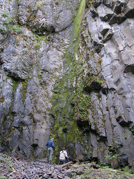
While Warren Creek now has an especially handsome bridge on the new state trail, the dry cliffs of beautiful Warren Falls (below) will continue to be a ghostly testament to the arrogance and carelessness of our modern age – except on those rare stormy days each winter when the falls briefly reappears (above).

warrenfallspostscript02

Warren Falls as it exists most of the time… for now…

Restoring the falls would have been the perfect companion to the HCRH State Trail project, itself an epic restoration project. Samuel Lancaster would surely have approved, too. It was a once in a century opportunity to do the work while heavy equipment was right in front of the falls. But if fighting City Hall is an uphill battle, then the castle walls at ODOT are still more foreboding.

The agency isn’t a monolith. There was encouragement and support from sympathetic professionals at ODOT along the way, albeit plenty of opposition from others. In the end, the agency formerly known only as the Oregon Highway Department revealed its roots, reluctant to step beyond its narrow right-of-way.

And yet the Historic Highway State Trail project, itself, is a bold step forward from simply building highways, and one the agency has been truly committed to. Thus, I’m hopeful about ODOT’s future, and the new state trail has much for us to be proud of.

warrenfallspostscript03

So very close… but not this time…

[click here for a larger view]

Perhaps most disappointing is ODOT’s lack of ownership and sense of responsibility for a stream diversion project that today would be considered a crime against nature. Even when Warren Creek was diverted and the falls destroyed in 1939, it was jarringly at odds with the vision and reverence for the landscape of Samuel Lancaster’s Columbia River Highway, and should have sent up red flags for the Highway Department.

Still more astonishing was learning during the course of this project that none other than Conde McCullough – engineering deity to many as the designer of Oregon’s most treasured highway bridges of the 1920s and 30s – signed off on the diversion project while serving as chief engineer!

Worse, we also learned along the way that it was completely illegal to destroy the falls, even back in 1939, as revealed in this article on the blog.  Oregon wasn’t a very big place back then, so it’s hard to believe the law protecting the falls went unnoticed at the time… but the truth on that point will likely never be known.

warrenfallspostscript04

Warren Falls flows briefly in 2015

Perhaps the greatest irony in the Warren Falls saga is that the original diversion project was designed to protect one the bridges on Sam Lancaster’s famous new road – by destroying one of the more spectacular waterfalls along the route. Lancaster died in March 1941, so it’s doubtful that he was even aware of the project as it moved forward in 1939. Let’s hope so, anyway.

Today, the crumbling diversion dam and tunnel are still listed as “assets” by ODOT, but are really just orphans, and now all but forgotten by the agency for the foreseeable future. Short of Oregon Parks and Recreation (OPRD) taking on the decommissioning as part of some sort of larger Warren Creek restoration project, the most likely outcome is continued deterioration of the diversion structure until nature finally reclaims it.

So, the campaign to restore Warren Falls is over… or is it?

Postscript… and premonition?

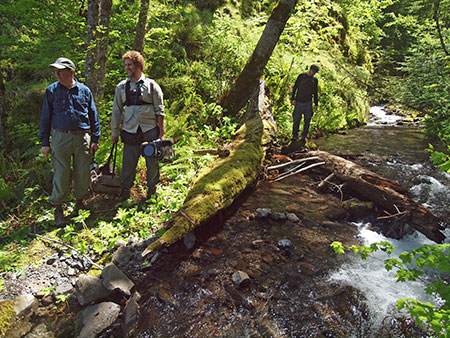
After years of attending meetings, writing letters, giving tours to all manner of advocates and officials and even a segment on OPB’s “Oregon Field Guide”, there weren’t many stones left to turn in coaxing ODOT to bring Warren Falls back to its original glory. On the surface, there’s very little to show for the effort.

But is that really true? It depends on how you define victory.

warrenfallspostscript05

OPB crew at Warren Falls in 2012

Yes, in the immediate future ODOT will continue to treat Warren Creek like a glorified storm culvert, and the former Warren Falls will continue to be a depository for “trash” (what the original engineers called the rock and woody debris we now know are essential to a stream health) separated from the creek’s flow. That’s a shame, and a missed opportunity for the agency to show that it has evolved from its “Highway Department” past.

warrenfallspostscript06

OPB crew above Warren Falls in 2012

But over the past five years, tens of thousands of people have learned the story of Warren Falls thanks to the OPB coverage, thousands more have viewed the WyEast Blog stories here and on the Restore Warren Falls Facebook page, and hundreds have visited the falls site, with more making the side trip each year to pay homage to what once was – and will be, again.

Until they see the silent cliffs where Warren Falls once flowed, most of these visitors have no idea that today’s Hole-in-the-Wall Falls is simply a man-made attraction that came at the cost of destroying Warren Falls. Armed with the history of Warren Falls, few who visit can view it as anything less than an environmental tragedy.

So, despite losing this round, Warren Falls has a lot of new friends, and a lot of people who love the Gorge have gained a better understanding of the lasting cost of “progress” and the chore of undoing our handiwork, even in places we seek to protect most.

Which brings me to…

(Not so) Secrets of the Monkey Wrench Gang…

Oh, how I wish I could share all of the schemes for liberating Warren Falls that have come my way over the past five years! They range from temporary performance art to more permanent alterations that would probably be illegal… if any governing entities were actually concerned about the fate of Warren Falls.

Still more surprising is the range of Monkey-Wrench-Gang-wannabes who proposed taking the restoration of Warren Falls into their own hands: you’ll just have to use your imagination, but some were rather prominent folks who left me speechless with their audacious plans.

So, I’ll share a few highlights, with the strict caveat from the WyEast Blog Legal Department:

NONE OF THESE ACTIVITIES APPEARS TO BE LEGAL, at least not without prior permission from the OPRD or ODOT (and good luck with that, by the way), and therefore the following DOES NOT CONDONE OR ENDORSE these ideas in any way!

Whew. Okay, well one of the most popular schemes is to roll plastic tarps over the giant “trash rack” that forms the screen over the Warren diversion tunnel. This would allow the pristine waters of Warren Creek to ride a plastic liner above the tunnel and over the natural falls. Sort of a giant slippery-slide, but with a real surprise at the end!

warrenfallspostscript07

The massive “trash rack” that turned Warren Falls dry in 1939

Someday (on my deathbed, or possibly at the dedication of a restored Warren Falls?) I may reveal an especially prominent individual who personally pitched a version of the slippery slide to me – truly, one of the more unexpected twists in this five-year saga!

Most versions of the slippery slide focused on getting a really good look at what an unaltered Warren Falls looked like via a temporary restoration. But Warren Creek gets pretty wild and wooly in winter, so this would likely be a very brief restoration.

There’s also the question of what would happen to the tarps, once swept away, as there is a lot of potential for adding more man-made junk to an already defaced stream (assuming the tarps didn’t get hung up on the cliffs or left hanging form the outflow to Hole-in-the-Wall Falls).

warrenfallspostscript08

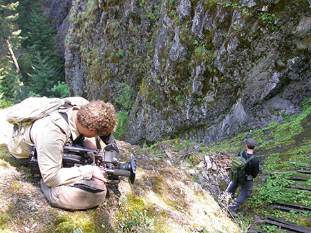
OPB’s Michael Bendixen filming the “trash rack” above the brink of Warren Falls in 2012

Others suggested (WyEast Blog Legal Department repeat notice: not condoning this!) speeding up the “weathering” process that has already begun to expose and compromise the steel beams that form the “trash rack” at the top of the falls.

It turns out that in just the ten years since I’ve been advocating to restore the falls, this part of the diversion has shown noticeable deterioration, and seems to be speeding up. It turns out the top of the “trash rack” is the weakest point in the design, and is steadily unraveling. So, I’m not sure Mother Nature needs much help at this point, despite the enthusiastic volunteers out there.

warrenfallspostscript09

OPB’s Michael Bendixen on top of the “trash rack” that rests on a cobble dam that is gradually eroding away

These photos show the vulnerability of the steel “trash rack” beams where the mortar that once fully embedded them above the diversion tunnel has been significantly compromised since 1939 by the relentless flow Warren Creek:

warrenfallspostscript10

A closer look at the lip of the “trash rack” showing the masonry cap on the cobble dam

warrenfallspostscript11

The masonry cap has worn thin where it anchors the top of the “trash rack” and a small garden flourishes where debris has clogged the giant grate

warrenfallspostscript12

Creative types see an opportunity to speed up the demise of the “trash rack” where these steel beams are almost freed from the concrete cap by weathering

The motive for speeding up the release of the beams varies among schemes and schemers.

One version is to allow enough stream material to pass under the protective “trash rack” to plug up the surprisingly narrow diversion tunnel leading to Hole-in-the-Wall Falls. Which is just 60” in diameter. This is probably what Mother Nature has in mind, though it may take awhile.

Another angle on speeding up the weathering at the top of the steel beams is to allow larger debris (logs, large rocks) to wedge between the beams, thus acting as levers to literally tear it apart with hydraulic pressure during high stream flow. To a large extent, this is already happening, as at least half the rack is plugged with smaller cobbles that are twisting and bending the steel beams with the effects of freeze and thaw during the winter months.

warrenfallspostscript13

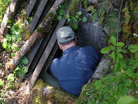
Vince Patton from Oregon Field Guide inspecting the access vault on the west end of the “trash rack”

At least one Warren Falls fan spotted the open vault above the west end of the diversion structure and suggested diverting the creek into this hole (WyEast Blog Legal Department reprise: this is not an endorsement! Plus, you might fall into a tunnel that spit out as a man-made waterfall!), where it could move debris large enough to plug the bypass tunnel. I’m not positive, but I think solid basalt prevents this from happening – either through creative monkey-wrenching or courtesy Mother Nature. But I was impressed at the attention to detail from those who love Warren Falls!

As much as I enjoyed hearing these inspired pitches for a DIY restoration of Warren Falls, one of the reasons I advocated for removing the “trash rack” structure and filling the bypass tunnel in an orderly way was to avoid having a bunch of steel debris entombed at the lip of this beautiful falls. I’d still much prefer a thoughtful decommissioning of the diversion over a disorganized mess – whether triggered by humans or nature.

We owe it to future generations to do this right. And who knows, we may still get the chance!

What the Future Holds: Warren’s Cousins

Short of an unforeseen intervention, the restoration of Warren Falls by forces of nature will take awhile. But it turns out that Warren Falls has some similarly trod-upon cousins in the area who have suffered flagrant abuse, then been abandoned to recover on their own.

The good news: in all cases, nature is winning… albeit, very slowly.

warrenfallspostscript14

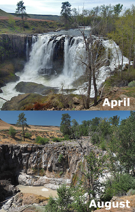
White River Falls needlessly goes dry each summer, thanks to a derelict Pacific Power diversion that sends the river around the falls (visible dropping in on the right).

A spectacular example is White River Falls, located in a state park by that name on the east side of Mount Hood. The falls is just upstream from the confluence of the White River with the Deschutes River.

More than a century ago, the Wasco Milling Company diverted much of the falls to a giant pipeline that fed a powerhouse downstream. Energy from the powerhouse was transmitted to The Dalles. Wasco Milling later sold the plant to Pacific Power, and it was finally shut down in 1960, when the land was transferred to the state of Oregon.

Pacific Power left quite a mess behind. The abandoned power plant, numerous pipelines and the diversion dam all still survive on state park land today. During high runoff in winter and spring the diversion channel is overwhelmed, and the former glory of White River Falls is on display. But by late summer, the entire flow is still diverted into the bypass channel, tumbling around the falls where the diversion pipe once existed.

warrenfallspostscript15

The derelict diversion channel at White River Falls

In this way, the situation at White River is not unlike present-day Hole-in-the-Wall Falls burping out of the Warren Falls bypass tunnel where it once connected to a flume that carried the creek over the old highway and to the Columbia River.

And like Warren Falls, the bypass channel “falls” at White River is a sad, ugly duckling compared to the magnificent original falls. But while there is no plan to formally decommission the diversion at White River Falls, the approach to the diversion dam is increasingly clogged with silt and debris, and should eventually fail, finally closing the chapter on the Wasco Milling Company era.

A few years ago, I reported on a now-scrapped scheme by Wasco County officials to reboot the White River generating plant, proving once again the wise words of John Muir: “Nothing dollarable is safe.” Even in an Oregon state park, it turns out.

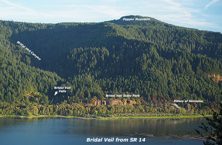
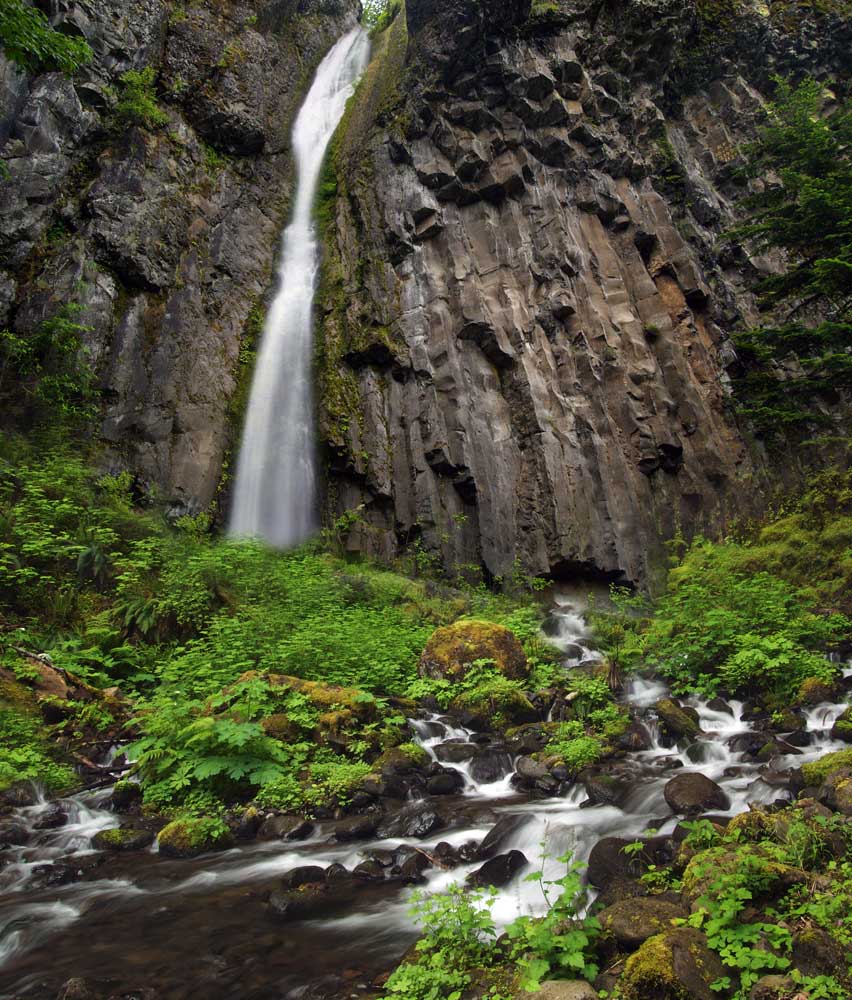
A closer cousin to Warren Falls is popular Bridal Veil Falls, located at the far west end of the Columbia Gorge. Though few of the thousands of visitors who hike to the base of Bridal Veil Falls each year can even imagine what this spot looked like just a few decades ago, it was one of the most heavily degraded areas in the Gorge.

warrenfallspostscript16

The lower tier of famous Bridal Veil Falls was altered for mill operations! Who knew?

The mill town of Bridal Veil was once located just 100 yards below the falls, though the town is now nothing more than concrete foundations and rusted cables covered in moss and undergrowth. In this eastward view (below) from the early 1900s, today’s Bridal Veil exit from I-84 to Multnomah Falls would be located near the buildings at the far end of the mill town.

warrenfallspostscript17

The mill town of Bridal Veil in the early 1900s

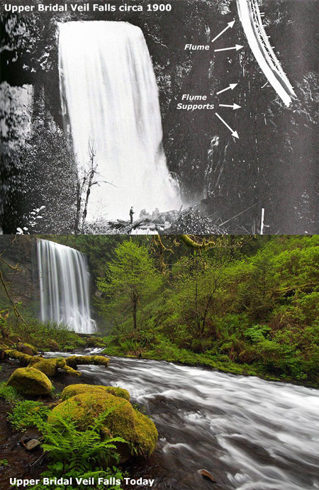
The pile of rough-cut timber in the foreground marks the terminus of log flumes that fed the Bridal Veil mill. At least three timber flumes carried logs and rough lumber to the mill from the slopes of Larch Mountain. One flume closely followed Bridal Veil Creek with the kind of roller coaster ride theme park “log rides” have tried to replicate ever since.

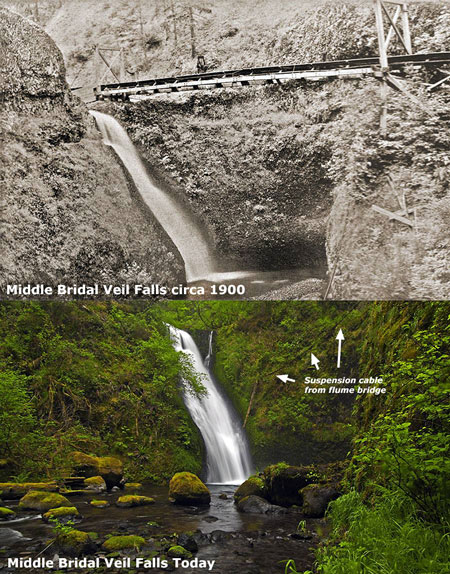
In the scene below (from about 1900) the audacious scale of the flume is evident as it courses down the canyon, about a mile above Bridal Veil Falls, and just below Middle Bridal Veil Falls. The area had already been heavily logged by this time and the stream was viewed as nothing more than a steady water source and convenient path for moving old-growth timber to the mill.

warrenfallspostscript18

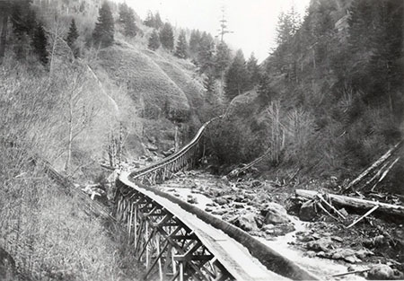
The main flume followed a ravaged Bridal Veil canyon to the mill

This view (below) of the converging flumes coming into the mill site conceals Bridal Veil Falls, which is located directly beneath the flumes. Today’s trail to the falls would have travelled under all three flumes where they converge in this scene.

warrenfallspostscript19

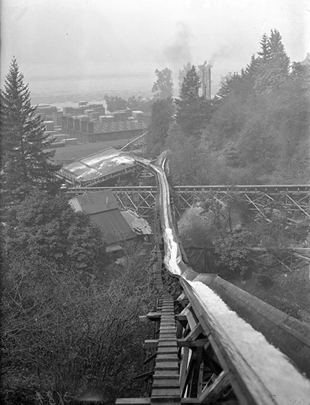
Flumes over Bridal Veil Falls (the falls is located directly below the flumes)

Bridal Veil Falls not only had a trio of log flumes passing overhead, the falls itself was also modified by the mill, presumably to carry water to the mill (though this is just my own speculation – I’d love to hear from mill historians who know more about this!)

The photo below shows the falls in the late 1800s, just before the lower tier had been raised about 15 feet, creating a pool below the upper tier and allowing for a diversion structure (?) to presumably carry a piped portion of the creek to the nearby mill.

During periods of low water today, you can still see parts of the diversion structure at Bridal Veil Falls poking from the water (below).

warrenfallspostscript21

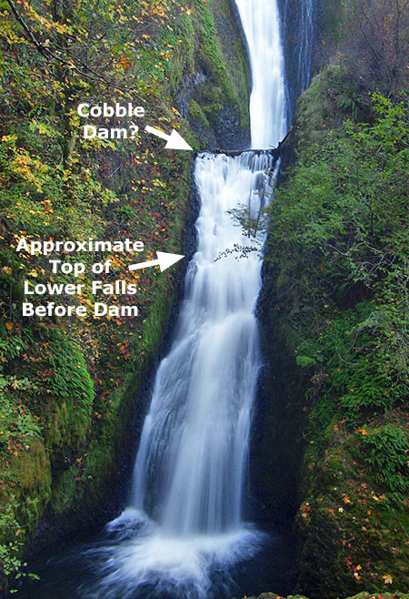
Lower tier of Bridal Veil Falls as it exists today

Here are detailed views of the diversion structure that raised the lower tier of Bridal Veil Falls to what we see today:

warrenfallspostscript22

A closer look at what seems to be a cobble dam that raised the height of the lower tier of Bridal Veil Falls…

warrenfallspostscript23

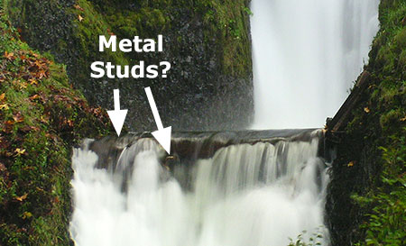
…and a still closer look…

This rare view from the early 1900s shows the diversion structure already in ruins or perhaps under construction? In either case, its purpose only lasted a short period, and in this way the falls is a kindred spirit to Warren Falls, where the short-lived diversion functioned for barely a decade before becoming obsolete and abandoned.

warrenfallspostscript24

The cobble dam shortly after construction… or perhaps after it was abandoned?

Today, there are still a lot of concrete and steel reminders of the mill town, though they’re often hidden in plain sight, under layers of rust, moss and ferns. For example, this view (below) of the stream below Bridal Veil Falls reveals a “boulder” that is actually a concrete footing and an intake pipe for one of the mill ponds.

warrenfallspostscript25

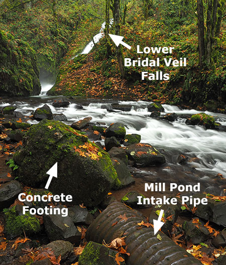
Mill relics hiding under moss at Bridal Veil Falls

Other large waterfalls on Bridal Veil Creek were impacted by the mill operation, but have recovered dramatically in the decades since the mill finally closed in the 1960s. Here are then-and-now photos of Middle and Upper Bridal Veil Falls:

warrenfallspostscript26

[click here for a larger version]

warrenfallspostscript27

[click here for a larger version]

In more recent years, stolen automobiles have periodically been pushed from the cliffs along historic Palmer Mill Road into Bridal Veil canyon. Some of these dumped vehicles have been pulled from the canyon, but others are too difficult to reach, and are slowly fading into the forest.

While they have undoubtedly released engine fluids into the creek and have plastic parts that will last for decades, nature and Bridal Veil Creek are nonetheless making short work of the rest of these vehicles.

warrenfallspostscript28

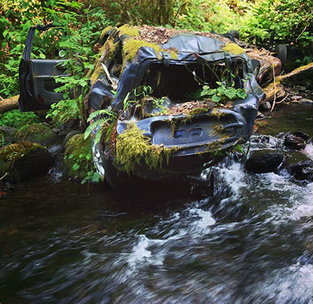
Moss and ferns consuming a dumped Hyundai Santa Fe just above Upper Bridal Veil Falls (photo courtesy Jamen Lee)

Unlike Warren Falls, the waterfalls on Bridal Veil Creek were never completely diverted from their natural streambed, yet the overall impact of logging and milling at Bridal Veil had a much larger impact on the larger watershed than anything Warren Creek endured. The fact that Mother Nature has consumed most of what wasn’t salvaged when the flumes were pulled from Bridal Veil canyon in the mid-1900s is an inspiration for the ongoing recovery of Warren Falls.

In time, all traces of our impact on the environment really can heal – provided we allow it to happen. Responsibly cleaning up after ourselves would be a more noble path, of course, but at least nature seems to forgive us in time… so far.

Warren Falls Lives!

warrenfallspostscript29

False alarm! Horsetail does look a lot like Warren Falls, though…

A few weeks ago, the local waterfall hunting community had a brief moment of excitement when a vintage 1918 film seemed to include a rare view of Warren Falls! But after looking more closely at the images, it turned out to be Horsetail Falls in very low flow. So, the hunt for a photograph of Warren Falls before the 1939 diversion project continues.

But the similarity was real, so the following is a rough guess of what we might see – and perhaps, sooner than we think: Warren Falls flowing again, returning its amazing amphitheater to mossy green, as the diversion structure continues to crumble into history.

warrenfallspostscript30

For waterfall devotees, this is Horsetail Falls superimposed on Warren’s dry cliff with the reversed base of Dry Creek Falls providing the foreground.

[click here for a large version]

Of course, we already know what a small amount of flow over Warren Falls looks like during high runoff events, as shown in previous photos in this article. What we don’t know is what the full force of Warren Creek might look like coming over this 120-foot escarpment, and especially what it might do with 77 years of accumulated stream debris piled at the base of the natural falls.

We have a pretty good idea, though, based on recent dam removals around the Pacific Northwest. It turns out that streams are surprisingly quick to redistribute accumulated debris and restore themselves to their natural stream state, as we’ve seen with dam removals on the Hood, Little Sandy and White Salmon rivers.

Today, Warren Creek below falls has been reduced to ditch, radically moved by ODOT from its former channel in the 1950s and devoid of the rocks and woody debris essential to a healthy stream since 1939, thanks to the “trash rack”.

warrenfallspostscript31

Add some rocks and logs to lower Warren Creek and it might look like this someday

[click here for a large version]

When Warren Falls returns, the huge pile of stream debris will begin to move downstream, and the debris-starved lower section of Warren Creek will develop the pools and eddies necessary for salmon and steelhead to spawn, as imagined above.

The good news is that the new HCRH State Trail passes high and wide over Warren Creek, ensuring that the creek can evolve back to a natural state in the future without a redux of the 1930s highway impacts that led to the diversion of Warren Falls.

When will Warren Falls return? Not just now… but perhaps sooner than we think.

Meanwhile, we wait… and watch.

_____________________

(Part two of this article will focus on a review of the newly completed Historic Columbia River Highway State Trail segment from Starvation Creek to Wonder Creek, and passing Warren Falls)

_____________________

 To revisit the complete history of the Restore Warren Falls project, here are earlier WyEast blog articles on the subject:

 An Overdue Warren Falls Update (and a bombshell!)

“Warren Falls Lives… Again?”

Warren Falls Solutions

“Warren Falls, we’re ready for your closeup…”

 Warren Falls Mystery… Solved!

Restoring Warren Creek Falls

_____________________

Warren Falls on Oregon Field Guide

_____________________

Restore Warren Falls on Facebook!


Proposal: Bridal Veil Canyon Trail

Upper Bridal Veil Falls

It is an unfortunate reality that in the face of Oregon’s population doubling over the past half-century, our trail system has declined. The resulting crowding and overuse is evident on many of the trails that remain, especially on those fringing the rapidly growing Portland region.

This trend is at odds with oft-stated public goals of better public access to nature, re-introducing children to the outdoors, providing more active, quiet recreation near our urban centers, shifting toward a more sustainable forest economy and creating affordable recreation in the interest of social equity.

So, what to do? Build more trails. Soon. And take better care of what we already have.

This article lays out a specific vision for one such trail, an all-season, family-friendly loop in the Columbia Gorge. This would not only be an important step toward meeting those public goals, but also could also become a flagship project for a renewed campaign to expand our trails to meet overwhelming demand.

The place is spectacular Bridal Veil Creek, known for its namesake falls, but less known is the string of waterfalls in its shady upper canyon, or the rich history that colors the area.

The Legacy of Bridal Veil

The town of Bridal Veil in 1900

Though deceivingly green and pristine today, the Bridal Veil watershed was once the center of what was arguably the most intensive logging operation in the region.

From 1886-1936, the company town of Bridal Veil thrived at the base of Bridal Veil Falls, on the banks of the Columbia River. The mill town at Bridal Veil was connected to a hillside sister mill community known as Palmer, located on the slopes of Larch Mountain. Today’s Palmer Mill Road survives as the connecting route between the two former mills.

Loggers near New Palmer in 1912

In the turn-of-the-century heyday of these mills, logs were rough-milled at the Palmer site, and sent down a mile-long flume to the Bridal Veil mill for finishing as commercial lumber. The terminus of the flume can be seen in the lower right of the first photo (above), with a huge pile of rough cut lumber piled at its base.

Timber was hauled to the holding ponds at the Palmer site along a series of rail spurs, traces of which can still be found today in the deep forests of Larch Mountain.

Jumbo steam engine hauling logs to New Palmer in 1905

The original Palmer site operated until a fire destroyed the mill in 1902, and the New Palmer mill was constructed nearby. New Palmer operated until the Bridal Veil Falls Lumbering Company shut down in 1936, a victim of the Great Depression and the largely logged-out Bridal Veil area.

Kraft Foods bought the mill and surrounding town in 1937, and formed the Bridal Veil Lumber and Box Company. Kraft manufactured its iconic wooden cheese boxes at the mill from 1937-1960, when Bridal Veil was finally shut down for good.

Old Palmer mill pond in 1896

The town site of Bridal Veil had already begun to fade when Kraft bought the community and mill in 1937, and today only the post office and cemetery survive. The tiny post office remains a popular attraction for mailing wedding announcements and invitations (with a “Bridal Veil, OR” postmark), and is now the sole reason for its existence. The cemetery saw its last burial in 1934, and local volunteers now maintain the grounds.

In 1990, the Trust for Public Lands purchased the Bridal Veil site, with the intention of clearing the remaining structures and transferring the land to the U.S. Forest Service for restoration. A decade-long legal battle ensued between local historic preservation interests and the Trust before the buildings were finally cleared, beginning in 2001. The last structure (a church) was demolished in 2011, leaving only the post office.

Log flume near Middle Bridal Veil Falls in 1896

Though the structures are mostly gone, remnants and artifacts from the Bridal Veil logging era are everywhere in the canyon: moss-covered railroad ties can still be seen on the old logging grades, concrete foundations line the old streets of the town, and chunks of suspension cable and rusted hardware follow the old flume corridor.

Sadly, there is also modern debris in the mix: illegal dumping has plagued Palmer Mill Road for decades, including automobiles that have been rolled over the canyon rim, tumbling into Bridal Veil Creek. At least three recently dumped autos are still lodged above the upper falls today, and several have already been pulled from the creek over the years.

Kraft cheese box

The combination of historic and nuisance debris lining this beautiful canyon present a couple of opportunities for the public. Clearly, the historic traces give a unique glimpse into the past, and an opportunity to interpret the logging history for present-day visitors.

But the nuisance debris also provides an opportunity to engage the public in a major cleanup of the canyon, and ongoing stewardship, in tandem with construction of a new trail.

The Proposal

This proposal for Bridal Veil canyon has two components:

1. Building a 2.5 mile hiking trail to spectacular views of the middle and upper waterfalls along Bridal Veil Creek

2. Converting Palmer Mill Road to become a bicycle trail

The focus of the proposal is on the hiking loop — a new, all-season trail that will offer a premier hike to families and casual hikers, while taking some pressure off crowded routes in the vicinity (such as Angels Rest, Latourell Falls and the Wahkeena-Multnomah trails).

The Palmer Road conversion is a secondary piece that responds to growing demand for new bike trails, as well as the failing state of the road for vehicular traffic (more about that, below).

The following trail map shows these proposals in detail:

(click here for a larger version of the map)

One of the unique advantages of building in the Bridal Veil watershed is the already impacted nature of the landscape. Adding a trail here is a modest change compared to a century of road building and logging. The proposal also provides an opportunity to restore some of the environmental damage from past activities in the process, such as illegal dumping and invasive species that have been introduced to the canyon.

Another unique advantage is the opportunity to extend the new trail from the existing trailhead and picnic facilities that exist at Bridal Veil State Park. The park already has a paved parking area, picnic tables, year-round restroom and a couple of short hiking trails. The new trail proposal would build on these amenities, making for a full-service for casual hikers or families with young kids.

Upper Bridal Veil Creek

The trailhead is also adjacent to rustic Bridal Veil Lodge, and would certainly complement the long-term operating of this historic roadhouse by greatly expanding recreation opportunities in the area.

The new trail would begin a few feet beyond the trailhead sign on the existing Bridal Veil Falls trail, turning upstream from the current path. The new route would duck under the Historic Columbia River Highway, and follow the west side of Bridal Veil Creek closely for 0.6 miles to a new footbridge at beautiful Middle Bridal Veil Falls. Here, a few moss-covered remains of the old log flume survive among the ferns and boulders.

Middle Bridal Veil Falls

The proposed loop forks here, with the stream-level route continuing along the west side of the creek, and the eastern bluff route returning across the proposed bridge (see map, above).

The stream-level route would now climb a switchback to an overlook of Middle Bridal Veil Falls, and continue to traverse the stream for a half-mile, passing two more mid-sized waterfalls. Soon, the trail would arrive at a second bridge, just below magnificent Upper Bridal Veil Falls.

The upper falls is the main attraction of the proposed loop trail — a powerful 100-foot wall of water in a steep amphitheater. Hikers will want to enjoy this spot for a while, perhaps from the proposed footbridge, or possibly from a viewing platform similar to the deck at Bridal Veil Falls.

Upper Bridal Veil Falls

After taking in the view of the upper falls, hikers would begin the traverse of the east side of the canyon, along the return portion of the proposed loop trail. This section would gently climb the steep canyon walls to a series of open bluffs that frame the gorge. Along the way, a spur trail would connect the loop trail to the proposed bike route along Palmer Mill Road.

The return route would end with a long switchback descent to the proposed footbridge at Middle Bridal Veil Falls, and hikers would retrace their steps for the final 0.6 miles to the trailhead. The new loop would be a total 2.5 miles, round-trip.

Bridal Veil Falls

The final piece of the puzzle in the trail proposal would be a short return loop on the existing Bridal Veil Falls trail. This route would climb from the existing viewing platform above Bridal Veil Falls, traversing below the scenic highway to a new stream crossing at the highway bridge. Though this route involves extra cost and engineering challenges, it would also create a longer loop that incorporates the existing Bridal Veil Falls trail, for a total of 3.5 miles.

Converting Palmer Mill Road

While the main focus of this proposal is on new hiking trails, the deteriorating state of Palmer Mill Road — and the serious problems it creates in terms of illegal dumping and vandalism — calls the question of whether to allow traffic on this road in the long term?

2011 slide on Palmer Mill Road (Multnomah Co.)

In 2011, the road was closed for several months to allow for repairs where a sizeable section had failed. Though unintentional, the statement on Multnomah County’s website makes the case for closing the road permanently:

“The isolated road is one of the county’s few remaining gravel roads. The narrow road climbs a steep hillside above Bridal Veil Falls along Bridal Veil Creek.

No homes or businesses are located along Palmer Mill Road. The road was built to serve logging mills in the 1880s that are now long gone. Few cars use the road, so not many people noticed when a landslide closed the route in March 2011, during one of the wettest winters in recent memory.”

At a time when county transportation funds are rapidly dwindling, converting the road to become a bicycle trail would not only help the health of Bridal Veil canyon, it could also remove some of the maintenance burden for the county. It also seems to fit the county’s own direction for the corridor, as the upper segment of Palmer Mill Road has been gated to vehicles for years, and is a favorite route among cyclists and hikers.

Palmer Mill Road in autumn

Like the proposed Bridal Veil loop trail, a bike trail along Palmer Mill Road already has a developed trailhead. In this case, the paved overflow lot for the Angels Rest trail provides ready-made parking. Therefore, no new accommodations for bike trail users would be needed (though the Angels Rest trailhead is not equipped with an all-season restroom or water).

(a caveat to this proposal: the steepness of Palmer Mill Road might limit its suitability for bikes, especially downhill, and therefore might need to be managed accordingly (like the Zigzag Trail near Surveyors Ridge, for example, which requires cyclists to walk bikes in the downhill direction).

What will it take?

This proposal will require a partnership between the U.S. Forest Service (administers the upper portion of the canyon), Oregon State Parks (administers the lower section) and trail advocacy groups. While the proposed loop represents a substantial amount of trail design, engineering and construction, it is well within reach if a public-private partnership can be realized.

The scope of the proposal is about the same as the Wahclella Falls trail, which was rebuilt in the 1990s to include two sizeable footbridges and sections of new tread on steep slopes. However, there would be little or no costs associated with the trailhead at Bridal Veil Canyon, unlike the Wahclella Falls project.

(click here for a larger view of this map)

(click here for a PDF version of this map)

Sound interesting? The best way to advocate for this trail is to simply pass the idea along. I will be advocating the project with Oregon State Parks, eventually, so word-of-mouth support among hikers could be helpful.

To share this concept, download the illustrated PDF version (above) of the map and send it to friends, fellow hikers or even to Oregon State Parks or Forest Service officials, with your own suggestions for how to proceed. That’s how grassroots projects get started, after all!
___________________________

Acknowledgements: this article has been underway for a couple of years, and reflects help from several local Gorge experts. My thanks go to Bryan Swan for his research on the history (and mystery) of Upper Bridal Veil Falls, and to Greg Lief and Don Nelsen for making bushwhack trips with me to Upper and Middle Bridal Veil Falls, respectively. Special thanks go to Zach Forsyth for his intrepid explorations along the less-traveled sections of the canyon, and advice on possible trail alignments.

Piggyback Plant

Piggyback plant

Hike along any low-elevation stream in the Cascades and you’re likely to pass colonies of Tolmiea menziesii — more commonly known as the piggyback plant. These humble plants draw their common name from a unique habit of sprouting new plants on top of their leaves (reflected in other common names for the species, including “youth-on-age” and “thousand mothers”).

The botanical name for this species memorializes two giants in the early days of Pacific Northwest botanical discovery: Scottish-Canadian botanist William Fraser Tolmie and Archibald Menzies, the Scottish naturalist for the Vancouver Expedition.

Young leaves on a piggyback plant

These fuzzy little plants thrive in the moist shade of streamside broadleaf trees like red alder and bigleaf maple. As forest floor dwellers, piggyback plants have become expert at reproducing. They can spread along their well-developed rhizomes, through seeds, and of course, through the tiny plantlets that form on their leaves.

A close look at the piggyback plant reveals a whorl of basal leaves, typical of the many species in the saxifrage family. The leaves have 5-7 lobes, and are finely toothed. Both leaves and stems are covered in fine white hairs that give them a soft texture to the touch.

Daughter plantlet on a piggyback plant mother leaf

Piggyback plants produce leaves continually from their base, with larger, older leaves eventually sprouting a “daughter” plantlet. The genius of this reproductive strategy is how it fits into the life cycle of the deciduous forests where the plants thrive. As the older leaves mature, they extend away from the mother plant on 4-6” stems, allowing daughter plantlets that form to touch down well away from the parent plant.

This is where the over-story of deciduous trees come in. Daughter plantlets form mostly over the course of the spring and summer growing season, By autumn, they are ready for falling maple and alder leaves to bury them, pressing tiny rootlets on the daughter plants into contact with the ground, where they can grow and anchor the new plant.

Underside of a mother leaf showing rootlets on a piggyback “daughter”

By the next spring, the new plant is ready to grow on its own, still fed by the nutrients from the fading mother leaf, and still with the connecting stem from the mother leaf forming an umbilical cord to the mother plant. Over time, the mother leaf and stem connecting to the daughter plant wither and die, and the daughter becomes truly independent from the parent.

In spring, piggyback plants produce clusters of tiny, graceful blossoms on 6-10” spikes. Each blossom is capable of producing a small seed capsule filled with tiny seeds. Flower stalks die back over the course of a summer, releasing seeds to grow side-by-side with the cloned plants that have sprouted from rhizomes and “piggyback” plantlets.

Piggyback plant flower (Wikimedia)

As a survival strategy, the seed offspring have the advantage of being cross-pollinated. Over time, seed-based offspring can evolve with the genes of two parents to have new survival characteristics that single parent cloned plants from root or leaf starts inherently lack.

Piggyback Plants in the Commercial Trade

Only a few native plants from Pacific Northwest forests have been hybridized to become commercial cultivars, and still fewer are suitable as indoor plants. The piggyback plant fills this rare niche, somehow adapting to the relatively hot, arid conditions indoors. They are typically sold as hanging basket plants.

Piggyback plant cultivar “Taff’s Gold”

The curious “piggyback” habit is the main attraction for growing the plants indoors. Breeders have created commercial hybrids with larger leaves, more “piggyback” plantlets and even a few variegated cultivars, such as the “Taffs Gold” Tolmiea shown above.

Starting Your Own Piggyback Plant

There’s no need to buy a piggyback plant, kids (and parents) can enjoy collecting and growing piggyback plants collected in the wild. You can make this a two-part adventure for kids by combining the collecting with a day hike, then propagating what you’ve collected at home.

Piggyback plants are plentiful along several family-friendly trails in the Columbia River Gorge: notable among these are the short trails to Latourell Falls, Bridal Veil Falls, Elowah Falls and Wahclella Falls.

On each trail, you’ll find piggyback plants in streamside areas and where deciduous trees grow. Your kids will quickly learn to spot them, and it’s okay to collect a few plantlets for growing at home, as you will be leaving the mother plant behind to produce more (an important lesson for kids).

Materials for starting your own plant

To grow your daughter plant, you’ll need the following:

• small pot (3-4 inches)
• soil-less potting mix
• bobby pin (or paper clip)
• rubber band
• plastic sandwich or freezer bag

Planting your starts is simple: (1) fill the pot to within 1” of the top with soil; (2) place the mother leaf and plantlet in the pot, with rootlets touching the soil; pin in place by pushing the bobby pin (or paper clip) over the mother leaf stem just below the plantlet, and holding it against the soil. Next, (3) sprinkle another 1/4” of potting mix, slightly covering the stem and base of the plantlet, and water well. Finally, (4) secure the plastic bag over the pot with the rubber band to provide a humid environment for the young plantlet to become established.

Piggyback start potted and ready to grow

Keep your new piggyback plant in a bright north or east-facing window, and covered with the plastic bag until you see the plantlet growing. At this point, you can remove the bag and watch your new houseplant grow — or plant it in your yard, where it will thrive in moist shade.

This is a terrific way to get young kids excited about the outdoors, and perhaps develop a green thumb in the process! You can start a piggyback plant at any time, as the plantlets can be collected year-round on the low-elevation Gorge trails listed above.